COMPARATIVE INVESTIGATION OF THREE AERIAL SURVEY METHODS FOR RIVER CHANNEL SURVEYING
Shigeki SANUKI, Satoshi WATANABE, Masataka MIYATA and Daiki KUSAKA
This purpose of this paper is to show the application of the small-medium river survey by using aerial survey technologies. We surveyed the Umetani river using Digital Aerial Cameras (DAC), Helicopter Laser Profiler (LP) and Unmanned Aerial Vehicle (UAV) in Gifu prefecture. We have also obtained the spots of surface elevation with topographical survey in river with VRS-GPS. As a consequence of surveying, we proved that aerial survey technologies were relative high precise. DAC was suitable for survey riverine environment in watershed scale. LP could obtain most precise surface elevation. UAV could survey river channel not only under the terrain canopy but also under the water depth up to 70cm. We proposed to apply aerial survey technologies to river survey in consequence of some good points.
Key Words : River surveying, Degital Aerial Cameras, Laser Profiler, Unmanned Aerial Vehicle, river management, Digital Surface Model, Digital Elevation Model
, 21 , 2015 6, 21 , 2015 6
- 105 -

- 106 -
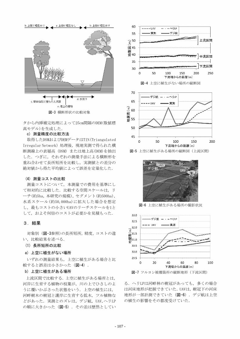
- 107 -

- 108 -

Hybrid
6)
6)
100m
1.4cm/pixel
UAV
10m1cm
- 109 -

UAV
UAV
UAV
(Airborne Laser Bathymetry)7)
GPS
1mUAV
1)
2006. 2)
11 77-82 2005.3)
16 241-246 2010. 4)
http://www.nilim.go.jp/lab/rcg/newhp/seika.files/lp/
- 110 -
Recommended
![W v4 >E ] 5 b Ý'ì 2 6õM %Ê'2library.jsce.or.jp/jsce/open/00906/2013/19-0171.pdf · 5 S b bmc /L b Íc W b d)z*L bmc /L bQ ... S34 S36 S38 S40 S42 S44 S46 S48 S50 S52 S54 S56 S58](https://img.pdfslide.us/doc/110x75/5af775157f8b9a8d1c904963/w-v4-e-5-b-2-6m-s-b-bmc-l-b-c-w-b-dzl-bmc-l-bq-s34-s36-s38-s40-s42.jpg)


![à Æå¢b4 / I ölibrary.jsce.or.jp/jsce/open/00906/2015/21-0349.pdf1= e ] /¡1= e7 '¨ s º v ö% b % "I ö@$ ^ ] 75b9× È )b )E)F 8#Ý_| È\à Æå¢b4 / "I ö:$7(5/($. 3,3,1*%(+$9,2562)5,9(5/(9((6](https://img.pdfslide.us/doc/110x75/5f21c5b029c328259d28b0f5/f-b4-i-1-e-1-e7-s-v-b-i-75b9-.jpg)

![b ®g ì lpM / & Øb s8jlibrary.jsce.or.jp/jsce/open/00906/2014/20-0497.pdf1= e ] /¡1= e7 '¨ s º v /b ®"g ì_ lpM / & Øb s8j THE EFFECTS OF SOIL DENSITY ON LIQUEFACTION INDISE](https://img.pdfslide.us/doc/110x75/5fb8ac5a9526cf119743b351/b-g-lpm-b-1-e-1-e7-s-v-b-g-lpm-.jpg)

![!) á S4 b ² p b v ~) slibrary.jsce.or.jp/jsce/open/00906/2014/20-0283.pdf · 2016. 2. 2. · Ì ] /¡1= e7 ,'¨20 s,2014 º6 v } ] _ > E 4( ó \!) á S4 b ² p b v ~) s CONSERVATION](https://img.pdfslide.us/doc/110x75/60deece8be4b5212d25f73f4/-s4-b-p-b-v-2016-2-2-oe-1-e7-20-s2014-6-v-.jpg)