Embed Size (px)
Citation preview
Geogaphica Timisiensis, vol. 19, nr. 2, 2010 (pp. 237-255) ●
CONCEPT AND STRATEGY OF DEVELOPMENT OF ROAD INFRASTRUCTURE IN MUREŞ COUNTY TO
REDUCE TERRITORIAL DISPARITIES AT MESOSCALE AND MICROSCALE 1
Part II. Practical Proposals
Vasile ZOTIC, Viorel PUIU, Diana-Elena ALEXANDRU, Ciprian MOLDOVAN
„Babeş-Bolyai” University, Cluj-Napoca
Faculty of Geography
Abstract: Concept and strategy of development of road infrastructure in Mureş County to reduce
territorial disparities at mesoscale and microscale. Road infrastructure is part of the territorial transport and communication infrastructure, which has the highest impact on development due to its specific features: accessibility, low costs for execution and maintenance, complementariness, diverse typology. These features promoted road infrastructure as the most advantageous pillar for supporting the intercontinental territorial development, which are characterized by various and unstable terrain, both at mesoscale and microscale. The strategy of development of Mureş County evaluated road infrastructure as the basic infrastructure in the development process. Starting from the analysis of current situation, along with all dysfunctions evaluated at a county level, this paper aims to develop a new concept of development of road infrastructure, theoretically based on the European and national framework regarding territorial development. The major objective of this concept is represented by the decrease of territorial disparities at both mesoscale and microscale within the county. Rezumat: Concept şi strategie de dezvoltare a infrastructurii rutiere în judeŃul Mureş penrtu reducerea disparităŃilor teritoriale pe microscală şi mesoscală. Partea 1I. Propuneri practice. Infrastructura rutieră face parte din infrastructurile teritoriale de transport şi comunicaŃie care au cel mai mare impact asupra dezvoltării datorită caracteristicilor specifice: accesibilitate, costuri reduse de execuŃie şi întreŃinerem complementaritate, diveristate. Aceste caracteristici fac din infrastructura rutieră cea mai avantajoasă componentă a dezvoltării teritoriale intercontinentale caracterizată de teren variat şi instabil atât la nivel de mezoscară şi macrăscară. Strategia de dezvoltare a JudeŃului Mureş consideră infrastructura rutieră drept infrastructura fundamentală în procesul de dezvoltare. Începând cu analiza prezentei situaŃii, împreună cu disfuncŃionalităŃile de la nivel judeŃean, această lucrare îşi propune să dezvolte un nou concept de dezvoltare al infrastructurii rutiere bazate teoretic pe concepŃia europeană şi naŃională asupra dezvoltării teritoriale. Obiectivul major al acestui concept este reprezentat de diminuarea disparităŃilor teritoriale atât la nivel de mezoscară cât şi de macroscală la nivel naŃional.
1 This paper is a synthesis of the chapter regarding technical infrastructure of the territory, roads section,
included in the project no. 63129/2007, Mureş County Spatial Plan (PATJ)

● Concept and Strategy of Development of Road Infrastructure in Mures County 238
Keywords: concept of development, strategy of development, road infrastructure, regional
disparities, scalar level Cuvinte cheie: concept de dezvoltare, strategie de dezvoltare, infrastructură rutieră, disparităŃi
regionale, nivel scalar.
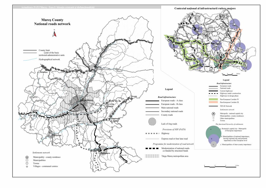
1. PUBLIC ROAD NETWORK IN MUREŞ COUNTY. CURRENT SITUATION AND DYSFUNCTIONS
Roads represent an essential element of national economic potential of a country,
most of the raw materials, freight, and labour force being transported on them, both at a national and international level. The trend of the increasing volume of goods transported by road is widespread in all countries. Sustaining this growth requires a more efficient road infrastructure, adapted to new vectors of traffic.
The classification of public roads of Mureş County (except for the streets) was established by the Presidential Decree no. 180/1984 based on the Law of Roads no. 13/1974, supplemented with GR nr. 649/1995 and amended by Ordinance 43 of August 28, 1997 with a view to the road regime.
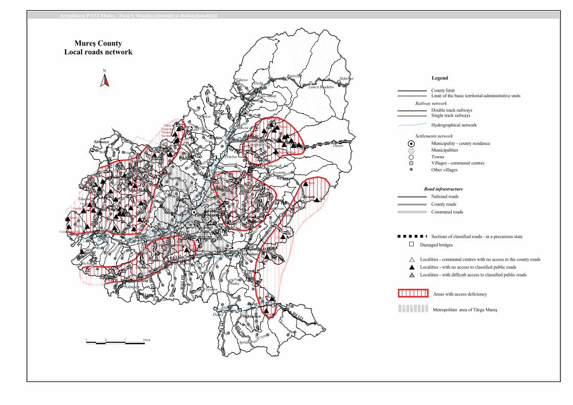
Public roads network of Mureş County – except for the town streets - includes 2099.9 km, distributed as it follows:
Table 1. Fig. 1. The length of public roads in Mureş County (on categories
of use). (Lungimea drumurilor publice din judeŃul Mureş, pe categorii)
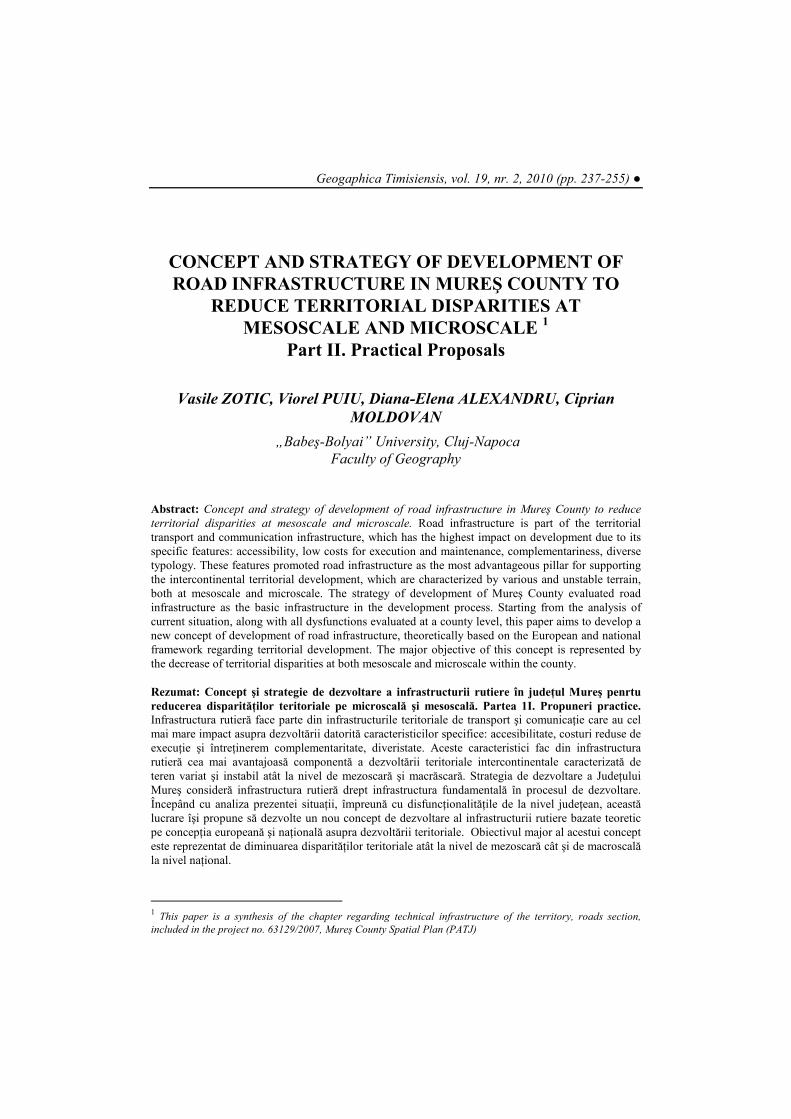
As compared to 1998, the length of all categories of public roads in Mureş County
increased, in accordance with the re-classification and introduction into the public circulation of new sectors of unclassified roads. This fact was positively reflected by the fortification of the communication potential in the county as a whole and also by the increasing number of settlements and their territories that became more accessible (Table 2).
The greatest increase in length is observed in the case of local roads (153 km), which represents an increase of 17.08% as compared to the data registered in 1998. Nevertheless, presently, a number of 50 localities in the county have access to a classified road included in the network of public roads. This aspect stands for one of the main dysfunctions of the county road network.
Nr. crt.
Category of road
Total length (km)
Ratio of the total length
(%) 1 National roads 428,868 20,42 2 County roads 774,602 36,89 3 Communal roads 896,469 42,69
4 Total length of public roads in MUREŞ County
2.099,939 100,00
Vasile ZOTIC, Viorel PUIU, Diana Elena ALEXANDRU, Ciprian MOLDOVAN ● 239
Table 2. The evolution of the length of public roads, in Mureş County, from 1998
to 2008. (EvoluŃia lungimii drumurilor publice în JudeŃul Mureş în perioada 1998-2008)
Nr. crt.
Type of road
1998 2008
Difference of length
(km)
Ratio of the
difference of length
(%)
The total
length (km)
Ratio of the total
length (%)
The total
length (km)
Ratio of the total
length (%)
1 National roads
358 19,39 428
20,42 70 16,36
2 County roads 745 40,36 774 36,89 29 3,75
3 Communal roads
743 40,25 896
42,69 153 17,08
4
Total length of public roads in MUREŞ County
1846 100,00 2099 100,00 252 12,00
Fig. 2. The evolution of the length of public roads, in Mureş County, from 1998 to
2008 (EvoluŃia lungimii drumurilor publice în JudeŃul Mureş în perioada 1998-2008)
The national roads are administered by by Mureş Regional Directorate of Roads and Bridges, as the representative of the Ministry of Transport, while county roads are administered by the Mureş County Council as the representative of the Régie Autonome of Mureş County Roads, and since January 1st, 1998, local roads have entirely been under the administration of local councils.
In the following, we will refer only to the road network, except for the streets located in municipalities.
● Concept and Strategy of Development of Road Infrastructure in Mures County 240
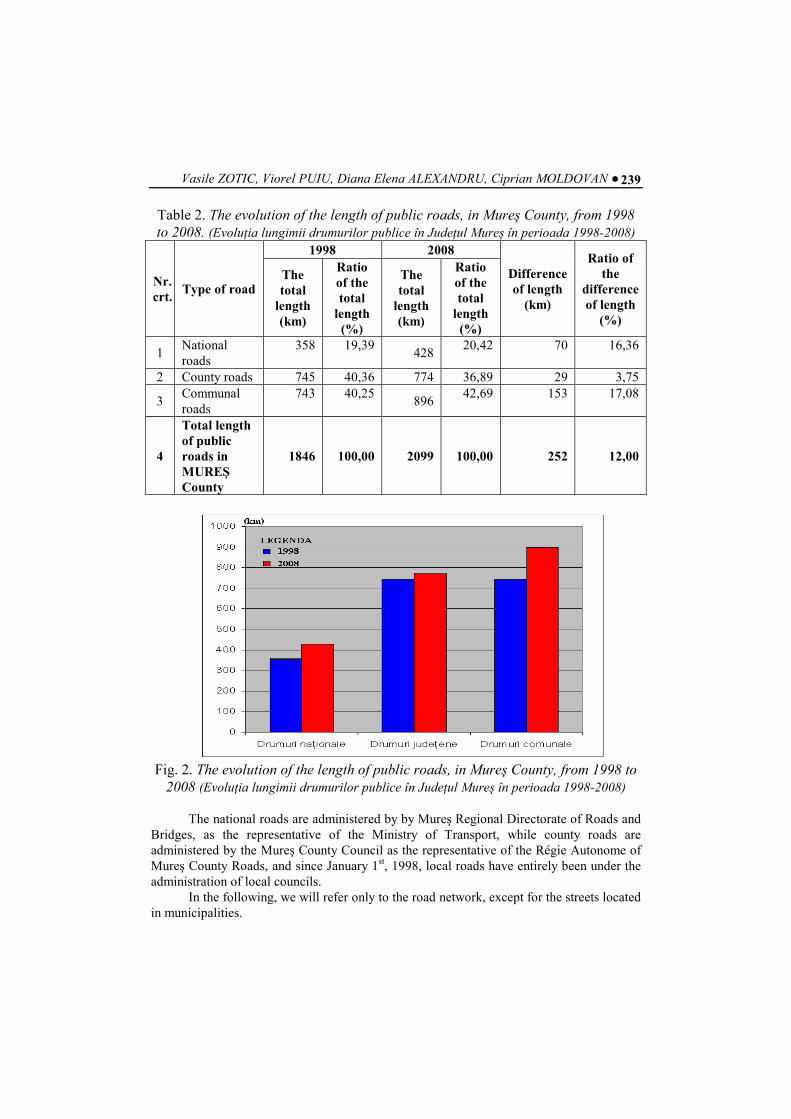
The situation of roads, by structure and technical conditions, on December, 31, 2007, revealed the following aspects (Table 3). After analysing the types of structures of public roads in Mureş County we can highlight the following aspects:
• a clear distinction between type of the road material and type of road; • more sectors or even the entire county road made of stone material; • some sectors of county roads still covered with earth (earth roads); • the low level of covering communal roads with asphalt; • most of the communal roads are either earth roads covered with stone or earth
roads. The clear distinction between the type of material used in making the roads and type
of road. This conception of equipping the public road is too old and carries the reminiscences of the former communist regime, fact that is decisively reflected in revealing the county potential of communications.
The relatively good maintenance of the public high class roads (European roads, the main national and secondary roads, and partially the county roads) and their cover with sustainable materials, as well as leaving the low class roads in total decay brings serious prejudice to the safety, comfort and freedom of movement.
Unlike other EU Member States, in which even the main agricultural roads are paved, in 2008, Romania still considers that properly equipping of the lower class roads is not a priority and that the rehabilitation of rural roads can be delayed.
The public administration of Mureş County supports this idea; hence, unfortunately, even if the national roads are properly equipped, or 100% of them are in the process of modernization, only 11.76% of the rural roads are paved with a thin layer of asphalt material, the rest being earth roads covered with stones (71.15%) or earth roads (16.74%).
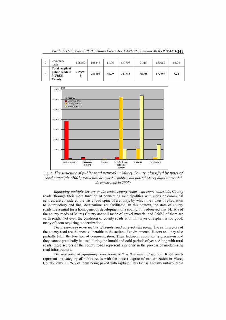
Table 3. The structure of public road network in Mureş County, classified by types
of road materials (2007) (Structura drumurilor publice din judeŃul Mureş după
materialul de construcŃie în 2007)
Nr. crt.
Type of road Total length
(m)
Length classified by types of road materials (m)
Concrete asphalt
(%) of the
total
Cement concrete
(%) of the total
Pavements
(%) of the total
1 National roads 428868 383744 89.48 19742 4.60 0 0
2 County roads 774602 9500 1.23 1000 0.13 6649 0.86
3 Communal roads
896469 600 0.07 747 0.08 1832 0.20
4
Total length of public roads in MUREŞ County
2099939
393844 18.76 21489 1.02 8481 0.40
Nr. crt.
Type of road Total length
(m)
Length classified by types of road materials (m) Roads
with thin asphalt layer
(%) of the
total
Stone roads
(%) of the total
Earth roads
(%) of the total
1 National roads 428868 21372 4.98 0 0 0 0
2 County roads 774602 624791 80.66 109716 14.16 22946 2.96
Vasile ZOTIC, Viorel PUIU, Diana Elena ALEXANDRU, Ciprian MOLDOVAN ● 241
3 Communal roads
896469 105443 11.76 637797 71.15 150050 16.74
4
Total length of public roads in MUREŞ County
2099939
751606 35.79 747513 35.60 172996 8.24
Fig. 3. The structure of public road network in Mureş County, classified by types of
road materials (2007) (Structura drumurilor publice din judeŃul Mureş după materialul
de construcŃie în 2007)
Equipping multiple sectors or the entire county roads with stone materials. County roads, through their main function of connecting municipalities with cities or communal centres, are considered the basic road spine of a county, by which the fluxes of circulation to intermediary and final destinations are facilitated. In this context, the state of county roads is essential for a homogeneous development of a county. It is observed that 14.16% of the county roads of Mureş County are still made of gravel material and 2.96% of them are earth roads. Not even the condition of county roads with thin layer of asphalt is too good, many of them requiring modernization.
The presence of more sectors of county road covered with earth. The earth sectors of the county road are the most vulnerable to the action of environmental factors and they also partially fulfil the function of communication. Their technical condition is precarious and they cannot practically be used during the humid and cold periods of year. Along with rural roads, these sectors of the county roads represent a priority in the process of modernizing road infrastructure.
The low level of equipping rural roads with a thin layer of asphalt. Rural roads represent the category of public roads with the lowest degree of modernization in Mureş County, only 11.76% of them being paved with asphalt. This fact is a totally unfavourable
● Concept and Strategy of Development of Road Infrastructure in Mures County 242
for the development of local rural communities, the state of road representing the identity card for the development of that community.
Communal roads (rural roads) are mostly made of gravel or earth. Most of the rural roads in the county are covered with stone (71.15%) and earth (16.74%) which means that over 88% of rural roads are still in an advanced stage of physical and moral use (Table 4).
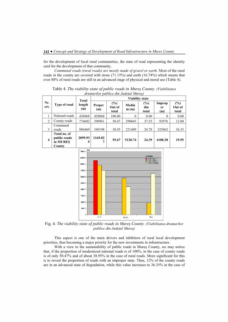
Table 4. The viability state of public roads in Mureş County. (Viabilitatea
drumurilor publice din JudeŃul Mureş)
Nr. crt.
Type of road Total length
(m)
Viability state
Proper (m)
(%) Out of total
Medium (m)
(%) din
total
Improper
(m)
(%) Out of total
1 National roads 428868 428868 100.00 0 0.00 0 0.00
2 County roads 774602 390961 50.47 290665 37.52 92976 12.00
3 Communal roads 896469 349198 38.95 221409 24.70 325862 36.35
4
Total no. of public roads in MUREŞ County
2099.939
1169.027
55.67 5120.74 24.39 4188.38 19.95
Fig. 4. The viability state of public roads in Mureş County. (Viabilitatea drumurilor
publice din JudeŃul Mureş)
This aspect is one of the main drivers and inhibitors of rural local development priorities, thus becoming a major priority for the new investments in infrastructure.
With a view to the sustainability of public roads in Mureş County, we may notice that, if the proportion of modernized national roads is of 100%, in the case of county roads is of only 50.47% and of about 38.95% in the case of rural roads. More significant for this is to reveal the proportion of roads with an improper state. Thus, 12% of the county roads are in an advanced state of degradation, while this value increases to 36.35% in the case of
Vasile ZOTIC, Viorel PUIU, Diana Elena ALEXANDRU, Ciprian MOLDOVAN ● 243
rural roads. These sectors of roads, characterized by a low state of viability, mostly coincide with gravel and earth roads (Fig. 4).
Table 5. The density of public roads (km/100 km
2) in the Centre Region of
Development (Densitatea drumurilor publice (km/100 km2) în Regiunea de Dezvoltare)
Nr. crt.
JudeŃul Densitatea
(km/100 km2) 1 Alba 42,3 2 Braşov 28,0 3 Covasna 22,6 4 Harghita 24,8 5 Mureş 29,6
6 Sibiu 29,4 7 Regiunea de
Dezvoltare Centru 29,9
8 ROMÂNIA 33,5
Public roads include 253 bridges with a length of 6100m, out of which 143 bridges
are located on national roads and 110 bridges on rural roads. The density of public roads in the county is of 31.26 km/100 km2, under the
national average, which is of 33.5 km/100 km2, yet with a higher value as compared to that registered by the Centre Region of Development (29.9 km/100 km2) (table 5). Regarding the current state of roads in Mureş County, we have to mention the following: The road network of Mureş County includes a number of risk sectors for the circulation,
such as:
• road sectors at risk of flooding; • road sectors at risk of snowing; • road sectors frequently foggy; • road sectors with dangerous curves and slopes;
Two of the most frequent dangerous slopes we can find on the sector of the national road (DN 16) between Târgu Mureş and Sighişoara, as well as on the national road (DN 15) located in Luduş area.
We find the road signs satisfying on the entire network of county roads, and rather insufficient on the rural roads. If marks are executed at least once a year on the national roads, in case of county and rural roads with permanent pavement, marks have not been made with the same regularity, while there are still some sectors of county and rural roads on which these marks have not ever been made. Nevertheless so important for the safety of movement at night and in the presence of fog, since 1996 the administrations have started works for marking the roads, even including local roads, both county and rural.
From the perspective of vertical signs placed on the national roads, they are fully reflective, while the county and rural roads have been equipped with such signs only on several major routes, in the latest few years.
Causes of the current technical state of public roads in Mureş County: • not considering investments in infrastructure as a priority, even if it represents a
key factor for the county development;
● Concept and Strategy of Development of Road Infrastructure in Mures County 244
• the discordance between the increase values of traffic and the budget allocated for road maintenance;
• the incomplete legislation and lack of a national strategy in this respect before 1995, and hardly carried out later;
• the lack of roads maintenance during 1980-1990, and their failure in the period 1990-2000, especially regarding local roads, both county and rural;
• some natural calamities that have adversely affected the current maintenance programs for the network of roads and bridges;
• the lack of specific high technology for carrying out the works before 2000, and their failure after 2000;
• the lack of specific materials for the execution of works before 1990 (bitumen, cement, mineral aggregates, fuel);
• the lack of qualified personnel for road works, especially after 1990, particularly workers and foremen;
• the poor quality of basic materials, particularly bitumen; • the non-funding works for the rehabilitation and modernization of county and rural
roads, in particular, fact that materialized only through the enforcement of maintenance works;
• the lack of ring roads in cities and the concentration of transit traffic in them; • the lack of escape routes (faster routes) for transiting the county.
2. OTHER TYPES OF ROAD. CURRENT SITUATION AND
DYSFUNCTIONS.
“Other roads” refers to the category of roads that includes roads, which, according to the law are not public, and that provide access to forest, agricultural areas and others. This category is particularly important in developing the overall road network, since they may either constitute sectors or real links between human settlements and areas (points) of interest, or can provide variants of access, and relationships between them.
2.1. Forest roads
Forest roads (FR) are roads constructed in purposes of forest management and for the transportation of timber, they providing the connection between forests and public road network. FR represent means of technological transport, of private utility, frequently used for: management of forests, hunting and fishing activities, interventions in case of damage, calamities or disasters; they are closed to the public circulation, except for uses like sports, recreation and tourism, which may be practiced only by the consent of the owner.
These roads are state property and they are included in the economic forest units. According to The Forest Code, FR are intended to serve the activity of forest
transport and they are closed for public circulation. In addition to forest transport, the access on these roads is allowed only for the vehicles belonging to the Ministry of National Defence.
Notwithstanding the general rule, the economic forest units may allow transportation on some FR for different organizations, at their request, and by signing an agreement. They
Vasile ZOTIC, Viorel PUIU, Diana Elena ALEXANDRU, Ciprian MOLDOVAN ● 245
may also allow the movement of private vehicles for tourist purposes, as well as for access routes to localities located on forest roads.
In terms of how to use, forest roads are classified into: • roads serving exclusively the interests of forest economy; • roads that mainly serve forest transport and those on which transport is authorized,
by agreement, for some shipments of industrial interest of other economic sectors; • roads used for forest transport on which, in addition to shipments of industrial
interest, is allowed the movement of in the purpose of tourism or for accessing some neighbouring localities.
It is prohibited to execute the transport on forest roads, except for the contracts (by signing an agreement).
Currently, in the county, there are 1140.4 kilometres of forest roads, out of which, most of them are consolidated, paved with stone or macadam.
Forest roads are currently used for other purposes also, mainly in animal farming (as access routes to mountain pastures and hayfields), for recreation activities (tourism), and less as access roads to the villages in the area, and the least in the mining activities.
Problems and dysfunctions: • the deplorable state of many forest roads (a single institution cannot ensure their
proper maintenance due to the total length of roads); • accelerating the morpho-dynamic processes, mainly linear erosion, due to the
unsuitable exploitation of forest roads; • the disruption of general ecological balance in the area. These roads have allowed
the deep penetration of human activities to areas recently "wild", not always civilized activities, such as: illegal forestry, tourism invasion, building vacation residences, over-pasturing, even in the recently cleared areas, therefore not allowing the regeneration of forests.
2.2. Agricultural roads
Agricultural roads represent a supplement for the existing county and rural roads,
they ensuring the movement of people, cars and cargo transport from and to the field, as well as the access to every wedge sole and aggregates of machines and tractors.
In the context of sustainable development, agricultural roads must meet the following requirements:
• the agricultural road network, along with the county and rural roads shall provide connections between the village and the production centres and field camps;
• they shall ensure the movement of trucks, aggregates of cars and tractors from a parcel to another;
• the location of road should be in accordance with the borders of the parcel that is worked on, with the forest protection belt, with the field camps, and also with the drainage or irrigation networks;
• the road route shall comply with the technical requirements, in terms of width and longitudinal slope;
● Concept and Strategy of Development of Road Infrastructure in Mures County 246
• the project should formulate the provisions regarding the minimal investment costs. There should be used the suitable existing roads, along with their bridges and other existing facilities.
According to their significance and purpose, agricultural roads are classified into: • main agricultural roads (main ways) – they serve the entire sets of plots and all
categories of use; they connect settlements and groups of crop lots, because, in some cases, they overlap the rural or county roads; it is recommended to be profiled and reinforced to widths of 6-8 m; they are projected in a straight line, so as to serve all soles in crop lots of 300-500 hectares;
• secondary agricultural roads – they are used to transport cargos on the long edge of the parcels of work; they make the connection with the main roads. They are also called supply roads when they serve the aggregates of cars and fuel tractors, water, seeds, as well as the making turn of empty the aggregates when executing field work. They are designed to have widths of 4-5 m; the location is on a side of plot, which is closer to the centre of the village, and the field camp shall be located where it is more convenient to organize the supply for the aggregates of machines.
As compared to the protection forest belts, roads are located on the side that dries more quickly in spring after snow melt (on the South, South-West, or South-East side). When the belt has a North-South direction, the road shall be located in front of the wind, mainly on the edge of forest belt, where less snow will be stocked. In the case of fields on slopes, the road is set above the forest belt so that the water from the snow melting shall not leak on the road.
In the case of fields on slopes, the main agricultural roads that gather the secondary roads shall be designed as winding roads with a maximum slope of 8-10 %. The secondary roads on slopes shall be projected on the long sides of the working plots on the direction of contour lines.
In all cases, there should be found all kinds of solutions so as to occupy a minimum size of arable land. In Romania, by the application of Law no. 18/1991, the old agriculture establishments and their agricultural property of about 6.8 million ha were divided into plots of 1 ha. Therefore, this led to a decrease of 900-1200 m2/ha in case of the cultivated area, agricultural roads occupying about 8% of the agricultural property, as compared to 1,5-2,8% in the lowland areas and to 1,9-3% in the hilly areas (in accordance with the standard).
3. STAGES OF DEVELOPMENT OF ROAD TRANSPORT INFRASTRUCTURE
Having in view those mentioned above, the proposals for the development of road
transport infrastructure in Mureş County were divided into three phases: Phase Ia. Priority, until 2012 - a specific most urgent sub-stage of interventions (red
lights) is mentioned for the following period (2009-2010). Phase Ib. Urgent interventions (period 2010-2011 - yellow lights). Phase II. Intermediate (period 2012-2015 - green lights). Phase III. For perspective (period 2016 – 2020).
Vasile ZOTIC, Viorel PUIU, Diana Elena ALEXANDRU, Ciprian MOLDOVAN ● 247
3.1. Measures, programmes 1. Establishing a strategy (vision) for the long-term development of transport
and communications infrastructure (the period estimated - 2050) Project description. Establishing such a long-term strategy is both a necessity and
a priority for the coherent development of infrastructure within the county and has to remain stable and become the basic framework for any review of the County Spatial Plan (PATJ) or of various plans of spatial planning, transport infrastructure as well as spatial (metropolitan), county and regional development. This measure will stop the incoherent and inconsistent development of infrastructure, which has resulted from the frequent changes of political regimes. Once this strategy is adopted and respected by the county administration, by implementing the measures in accordance with the phases outlined, it should be in compliance with the European technical and functional standards of infrastructure.
Actors involved/responsible. The County Council, the Centre Regional Development Agency, the Ministry of Transport and Infrastructure.
Period of execution: 2010 2. Starting the elaboration of the pre-feasibility, feasibility and technical studies
for the major infrastructure projects within the county for setting the utility of land, required by the project description.
Project description. Given the long period necessary for the elaboration of the pre-feasibility, feasibility and technical studies, in case of the major infrastructure projects, their initiation has to be achieved in time. It will be established the exact route and the size of land allocated for the execution of construction works.
Actors involved/responsible. The County Council, the Centre Regional Development Agency, the Ministry of Transport and Infrastructure.
Period of execution: 2011 3. Finalizing the technical studies for the ring roads in Tg. Mureş - the Southern
alternative, Reghin, and Sighişoara, so as to start working on the land issue, archaeological works and starting the execution works.
Project description. The finalization of these technical studies for the ring roads represents an absolute priority for the beginning of execution works. Ring roads will determine a decrease in the urban traffic congestion and they will eliminate the traffic transit.
Actors involved/responsible. The County Council, the Local Councils, the Centre Regional Development Agency, the Ministry of Transport and Infrastructure.
Period of execution: 2010 4. Classification of local earth roads into village roads to shorten the distances
of access to the communal centre. Project description. The project aims to classify some of the local earth and
agricultural roads into village roads in order to shorten the distance of access for a number of villages to the communal centre. Currently, the access from some villages to the communal centre is made on alternative routes of 30-40 km distance, fact that is completely different from the situation in which people have to transit distances of 3-4 km. This condition severely restricts people's access to a range of important public services such as: administrative, educational, health. Therefore, we propose the following classification of local earth roads into village access roads: the extension of DC 51 to villages of Boiu and
● Concept and Strategy of Development of Road Infrastructure in Mures County 248
Jacu, Albeşti commune; the extension of DC 77 to Subpădure and Cuştelnic villages; Mica commune: a connection road from the communal centre to Somoştelnic village and its extension towards DC 73. The proposals are graphically represented in the maps.
Actors involved/responsible. The County Council, the Directorate for Projects, Technical Development and Investment Programmes of the County Council, the Local Councils
Period of execution: 2010 5. Programme of transforming the proposed roads into public and communal
roads to connect all villages. Project description. The programme stipulates the classification of the proposed
roads into public communal roads to connect all settlements in the county, which currently have no road connections, to the public access roads, and their modernization (table 5). The proposals are graphically illustrated in the maps.
Actors involved/responsible. The County Council, the Directorate for Projects, Technical Development and Investment Programmes of the County Council, the Local Councils
Period of execution: 2010
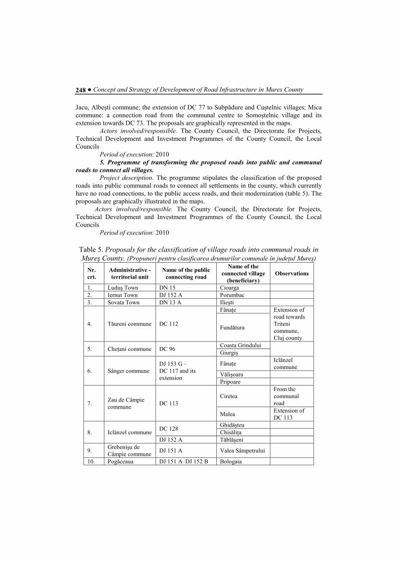
Table 5. Proposals for the classification of village roads into communal roads in
Mureş County. (Propuneri pentru clasificarea drumurilor comunale în judeŃul Mureş)
Nr. crt.
Administrative - territorial unit
Name of the public connecting road
Name of the connected village
(beneficiary) Observations
1. Luduş Town DN 15 Cioarga 2. Iernut Town DJ 152 A Porumbac 3. Sovata Town DN 13 A Ilieşti
4. Tăureni commune DC 112
FânaŃe Extension of road towards Triteni commune, Cluj county
Fundătura
5. CheŃani commune DC 96 Coasta Grindului
Giurgiş
6. Sânger commune DJ 153 G – DC 117 and its extension
FânaŃe Iclănzel commune
Vălişoara Pripoare
7. Zau de Câmpie commune
DC 113 Ciretea
From the communal road
Malea Extension of DC 113
8. Iclănzel commune DC 128
Ghidăşteu ChisăliŃa
DJ 152 A Tăblăşeni
9. Grebenişu de Câmpie commune
DJ 151 A Valea Sâmpetrului
10. Pogăceaua DJ 151 A–DJ 152 B Bologaia
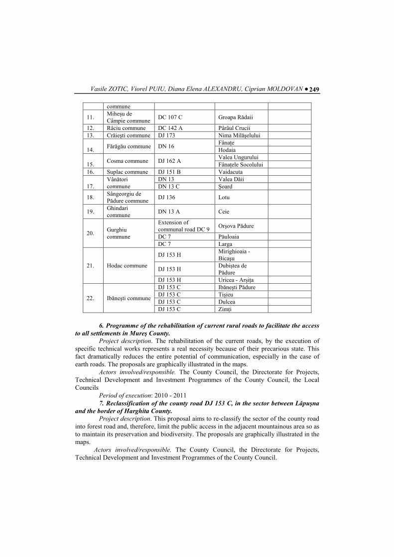
Vasile ZOTIC, Viorel PUIU, Diana Elena ALEXANDRU, Ciprian MOLDOVAN ● 249
commune
11. Miheşu de Câmpie commune
DC 107 C Groapa Rădaii
12. Râciu commune DC 142 A Pârâul Crucii 13. Crăieşti commune DJ 173 Nima Milăşelului 14.
Fărăgău commune DN 16 FânaŃe Hodaia
15.
Cosma commune DJ 162 A Valea Ungurului FânaŃele Socolului
16. Suplac commune DJ 151 B Vaidacuta 17.
Vânători commune
DN 13 Valea Dăii DN 13 C Şoard
18. Sângeorgiu de Pădure commune
DJ 136 Lotu
19. Ghindari commune
DN 13 A Ceie
20. Gurghiu commune
Extension of communal road DC 9
Orşova Pădure
DC 7 Păuloaia DC 7 Larga
21. Hodac commune
DJ 153 H Mirighioaia - Bicaşu
DJ 153 H Dubiştea de Pădure
DJ 153 H Uricea - ArşiŃa
22. Ibăneşti commune
DJ 153 C Ibăneşti Pădure DJ 153 C Tişieu DJ 153 C Dulcea DJ 153 C ZimŃi
6. Programme of the rehabilitation of current rural roads to facilitate the access
to all settlements in Mureş County. Project description. The rehabilitation of the current roads, by the execution of
specific technical works represents a real necessity because of their precarious state. This fact dramatically reduces the entire potential of communication, especially in the case of earth roads. The proposals are graphically illustrated in the maps.
Actors involved/responsible. The County Council, the Directorate for Projects, Technical Development and Investment Programmes of the County Council, the Local Councils
Period of execution: 2010 - 2011 7. Reclassification of the county road DJ 153 C, in the sector between Lăpuşna
and the border of Harghita County. Project description. This proposal aims to re-classify the sector of the county road
into forest road and, therefore, limit the public access in the adjacent mountainous area so as to maintain its preservation and biodiversity. The proposals are graphically illustrated in the maps.
Actors involved/responsible. The County Council, the Directorate for Projects, Technical Development and Investment Programmes of the County Council.
● Concept and Strategy of Development of Road Infrastructure in Mures County 250
Period of execution: 2010 8. Programme for the modernization of existing county roads to improve the
safety and comfort of movement Project description. The modernization of the county roads, characterized by an
advanced physical and moral use (especially in the case of the stone and earth roads), represents a priority for increasing the safety and comfort of movement within the county. The proposals are graphically illustrated in the maps.
Actors involved/responsible. The County Council, the Centre Regional Development Agency, the Directorate for Projects, Technical Development and Investment Programmes of the County Council.
Period of execution: 2010 - 2015 9. Modernization of the national roads: Apahida –Reghin; DN 14 Teiuş – Blaj –
Mediaş – Sighişoara. Project description. The modernization of the two national roads is set as a priority
for Mureş County, since they will support traffic outside the county, until new highways and four-lane roads are executed and start to function. They connect the North and South ends of the county and maintain traffic outside the county. The proposals are graphically illustrated in the maps.
Actors involved/responsible. The County Council, the Centre Regional Development Agency, the Ministry of Transport and Infrastructure, the Directorate for Projects, Technical Development and Investment Programmes of the County Council.
Period of execution: 2010-2011 10. Modernization of national roads: DN 14 A Iernut - Târnăveni - Mediaş, DN
15 E Satu Nou - Sânpetru de Câmpie - Râciu - Tg. Mureş Project description. The modernization of the two secondary national roads is a
priority for the county development because they facilitate the North-South connections. Much more, these roads will support the future development of other categories of public roads of inferior rank (county, communal). By rehabilitation, these roads are proposed to achieve the technical class III, having a band and half on the direction of travelling. The proposals are graphically illustrated in the maps.
Actors involved/responsible. The County Council, the Centre Regional Development Agency, the Ministry of Transport and Infrastructure, the Directorate for Projects, Technical Development and Investment Programmes of the County Council.
Period of execution: 2010-2011 11. The construction of a ring road for transferring the transit traffic in case of
municipalities: Tg. Mureş - the southern alternative, Reghin and Sighişoara. Project description. Building ring roads comes as a necessity in urban
development, to relieve the internal traffic and redirect the traffic outside the urban area. Currently, all three cities have developed only intra-urban ring roads, which gradually became urban streets; hence, the transit traffic problem remained basically unsolved. Therefore, the ring roads are proposed to be constructed outside the urban areas, this way removing all transit traffic from inside (especially the heavy one). These ring roads are proposed to achieve the technical class III, and in case of connection with public roads, the road junction will be achieved through roundabouts. In sectors where topography allows, or there are ramps or slopes it is proposed to develop two-lane roads for increasing the traffic flow. The proposals are graphically illustrated in the maps.
Vasile ZOTIC, Viorel PUIU, Diana Elena ALEXANDRU, Ciprian MOLDOVAN ● 251
Actors involved/responsible. The County Council, the Centre Regional Development Agency, the Ministry of Transport and Infrastructure, the Directorate for Projects, Technical Development and Investment Programmes of the County Council.
Period of execution: 2010-2011 12. The involvement of county administration in order to support the
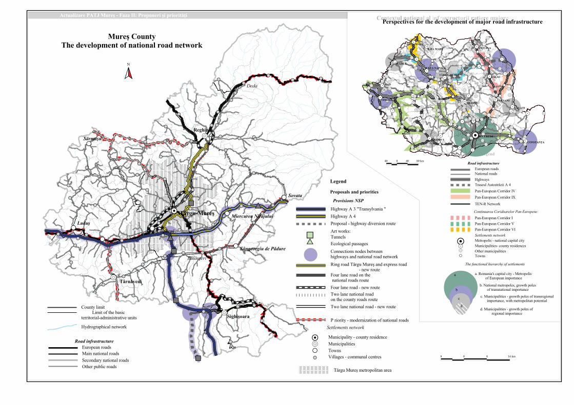
construction of A 13 Transylvania Highway, the route between: Turda – Târgu Mureş – Sighişoara – Făgăraş.
Project description. Currently, Transylvania Highway is the main major road infrastructure in Romania, being in the phase of design and execution. Its realization is expected to end in 2013 (preliminary deadline); hence, it will create an axis of connection between the central, North-West and South areas of the country, of which Mureş county will benefit, since it axially develops within the county and it connects four cities and municipalities among which we can mention Tg. Mureş. Transylvania Highway will be the major road axis for Mureş County, as it will support and develop the other lower class road networks, as well as becoming the key factor for the future economic and urban development of the county. The proposals are graphically illustrated in the maps.
Actors involved/responsible. The County Council, the Centre Regional Development Agency, the Ministry of Transport and Infrastructure, the Directorate for Projects, Technical Development and Investment Programmes of the County Council.
Period of execution: 2010-2013 13. The involvement of county administration, in order to support the construction
of the 4 lane road, on the route: Moisei – Năsăud – BistriŃa – Reghin – Târgu Mureş
Project description. The 4 lane road on the route: Moisei – Năsăud – BistriŃa – Reghin – Târgu Mureş will represent the North-South road axis connecting Mureş County with its neighbouring counties (BistriŃa, Maramureş). In order to properly manage the traffic flow between Târgu Mureş and Reghin municipalities, as well as to strengthen the economic relationships between them, to support the development in upper corridor of Mureş River, we propose a reclassification of the road sector with 4 lanes into an express road between Târgu Mureş and Reghin. The proposals are graphically illustrated in the maps.
Actors involved/responsible. The County Council, the Centre Regional Development Agency, the Ministry of Transport and Infrastructure, the Directorate for Projects, Technical Development and Investment Programmes of the County Council.
Period of execution: 2012-2015 14. The involvement of county administration, in order to support the
construction of the 4 lane road, on the route: Reghin – Miercurea Ciuc – Târgu Secuiesc.
Project description. This road infrastructure will strengthen the county communication potential with the neighbouring Eastern counties until the functioning of A16 Highway - Moldova. It will also support the development of settlements in the Mureş Defile; Reghin municipality will become the second most important road junction of Mureş County. The proposals are graphically illustrated in the maps.
Actors involved/responsible. The County Council, the Centre Regional Development Agency, the Ministry of Transport and Infrastructure, the Directorate for Projects, Technical Development and Investment Programmes of the County Council.
Period of execution: 2012-2015
● Concept and Strategy of Development of Road Infrastructure in Mures County 252
15. The involvement of county administration to support the construction of the 4 lane road on the route: Sibiu – Mediaş – Sighişoara – Odorheiu Secuiesc – Miercurea Ciuc.
Project description. This road infrastructure will provide the connection the Southern part of the county to the neighbouring counties (Sibiu, Braşov, Covasna) and it will also represent the basic road infrastructure for the development of the secondary one. Sighişoara Municipality will become a second road hub of Mureş County, fact that will sustain its socio-economic development but also the management of tourist potential. The proposals are graphically illustrated in the maps.
Actors involved/responsible. The County Council, the Centre Regional Development Agency, the Ministry of Transport and Infrastructure, the Directorate for Projects, Technical Development and Investment Programmes of the County Council.
Period of execution: 2012-2015 16. Modernization of three roads of inter-county (regional) importance, with the
possibility of reclassification to the rank of national roads: DJ 153 Reghin – Sovata; DJ 151 Luduş – Sărmaşu – LechinŃa; DJ 106 Sighişoara – Apold – Sibiu.
Project description. The modernization of the three county roads and including them into the category of technical class III, of inter-county and regional importance, with the possibility of reclassification into the category of the national secondary roads, are designed to increase the polarization level of the territory and support the inter-county traffic, by establishing high rank county road infrastructure. The modernization of DJ 153 Reghin - Sovata will provide Reghin direct connection to the A16 highway Moldova and will facilitate the traffic coming from Maramureş and BistriŃa-Năsăud on the 4 lanes road: Moisei – Năsăud – BistriŃa – Reghin. The proposals are graphically illustrated in the maps.
Actors involved/responsible. The County Council, the Centre Regional Development Agency, the Ministry of Transport and Infrastructure, the Directorate for Projects, Technical Development and Investment Programmes of the County Council.
Period of execution: 2012-2015 17. Establishing new classified roads in the metropolitan area of Tg. Mureş to
polynuclear development. Project description. This proposal aims to develop new routes for the classified
roads located within the metropolitan area, in order to connect new economic establishments for the exploitation of local resources, so as to ensure a polynuclear development. Supporting the polynuclear development in the metropolitan area represents the most viable alternative to turn it into a functional structure. The proposals are graphically illustrated in the maps.
Actors involved/responsible. The County Council, the Centre Agency for Regional Development, the Directorate for Projects, Technical Development and Investment Programmes of the County Council.
Period of execution: 2012-2015 18. Establishing classified roads to support the micro-regional development. Project description. In the micro-regions of development, bordered within Mureş
County (others than the associated micro-regions), it is necessary to plan the rehabilitation or the re-classification of public roads, so as to support the micro-regional development. The proposals are graphically illustrated in the maps.
Vasile ZOTIC, Viorel PUIU, Diana Elena ALEXANDRU, Ciprian MOLDOVAN ● 253
Actors involved/responsible. The County Council, the Centre Regional Development Agency, the Directorate for Projects, Technical Development and Investment Programmes of the County Council.
Period of execution: 2012-2015 19. Establishing and extending public roads for setting-up inter-county direct
connections for the micro-regional cooperation. Project description. This proposal lays down the provisions for the extension or
improvement of sectors of public rural roads, so as to achieve the micro-regional collaboration. By creating a local direct connection to support the local micro-regional cooperation, it can lead to the diversification of local relationships between them and also to provide a more facile access outside county limits. Therefore, we propose works on the following sectors of the road: Vişinelu (Sărmaşu commune) – limit of Cluj County; BăiŃa (Lunca commune) – limit of BistriŃa County; Deleni (Băgaciu commune) - limit of Sibiu County; Idiciu (Bahnea commune) – limit of Sibiu County; GâmbuŃ (Bichiş commune) – limit of Alba County; Solocma (Ghindari commune) – limit of Harghita County. The proposals are graphically illustrated in the maps.
Actors involved/responsible. The County Council, the Centre Regional Development Agency, the Directorate for Projects, Technical Development and Investment Programmes of the County Council.
Period of execution: 2012-2015 20. Establishing earth local roads for accessing the isolated areas. Project description. This proposal stipulates the modernization of earth local
roads, firstly by paving them with stones, subsequently being proposed for re-classification into communal roads, so as to provide access to remote areas, which could be included into the economic cycle by setting-up several agricultural farms. This measure is mainly necessary in the plain area of Mureş County, in which case the access to the farms is achieved through precarious agricultural roads. The proposals are graphically illustrated in the maps.
Actors involved/responsible. The County Council, the Centre Regional Development Agency, the Directorate for Projects, Technical Development and Investment Programmes of the County Council, the Local Councils.
Period of execution: 2012-2015 21. Establishing tourist roads with mixed-function. Project description. This measure aims to establish several tourist roads in areas
that have high tourism potential, by superposing them to some of the current classified roads or earth local roads. The sectors of roads may also have mixed-use, and they can also be used for various purposes, other than tourism. The sectors of the tourist roads proposed for this purpose are the following: Apold – Daia – Saschiz; Mihai Viteazu – Archita; Ozd – Bobohalma; Cucerdea – Giuluş – Lăscud – Somoştelnic. The proposals are graphically illustrated in the maps
Actors involved/responsible. The County Council, the Centre Regional Development Agency, the Directorate for Projects, Technical Development and Investment Programmes of the County Council, the Local Councils.
Period of execution: 2010-2011
● Concept and Strategy of Development of Road Infrastructure in Mures County 254
22. The involvement of the county administration in actions for supporting the construction of the A16 Motorway, the sector of Târgu Mureş – Piatra NeamŃ – Roman – Târgu Frumos – Iaşi – Sculeni
Project description. Moldova Highway will be the second major infrastructure of Mureş County and it will support the road traffic both to the East part of the country and also across borders. Its implementation is expected to be finished by 2013 and transform Mureş County in a transit hub for traffic transit on the West-East direction, and transform Târgu Mureş city in an important road junction and a socio-economic development pole. The proposals are graphically illustrated in the maps.
Actors involved/responsible. The County Council, the Centre Regional Development Agency, the Ministry of Transport and Infrastructure, the Directorate for Projects, Technical Development and Investment Programmes of the County Council.
Period of execution: 2016-2020 23. Doubling the major roads on the opposite side of the main rivers in the
county Project description. This proposal fosters the construction of new sectors of public
roads and proposes to connect the current routes to provide continuous access to villages on the opposite side of the large rivers in opposition to the current ones. It would also create several alternative access routes on the same direction and provide access to several localities situated on the opposite side of river. This measure, correlated with the construction of bridges at points of convergence of several roads, would set the connection with such settlements. This measure is proposed for the rivers of Mureş, Târnava Mare, Târnava Mică, and Niraj. The proposals are graphically illustrated in the maps.
. Actors involved/responsible. The County Council, the Centre Regional Development Agency, the Ministry of Transport and Infrastructure, the Directorate for Projects, Technical Development and Investment Programmes of the County Council.
Period of execution: 2016-2020
4. CONCLUSIONS In the context of territorial development of Mureş County, road transport
infrastructure has been and it still remains the most attractive modality of transport. Because of the multiple advantages that road transport has in the process of territorial development at the mesoscale and microscale, in the near future it will continue to remain the basic infrastructure in the transport of goods and people. In this respect, this paper proposes a new plan-space configuration of Mureş road infrastructure that shall optimally respond to the new trends in spatial development. Much more, the new configuration of public road network means to reduce regional disparities at the mesoscale and microscale, which appeared and perpetuated in the county as a result of the uneven distribution of road infrastructure in the territory, and also determined by the lack of specific types of roads, with certain class and technical rank in accordance with the current and future needs. Both the text and the maps are contributing to the thorough analysis of the current situation and proposals; therefore, the new plan-space configuration of Mureş county road infrastructure can be noticed, all proposals having the deadline until the interval 2015 - 2020, supporting the spatial development process at least until 2050.
Vasile ZOTIC, Viorel PUIU, Diana Elena ALEXANDRU, Ciprian MOLDOVAN ● 255
REFERENCES Antonescu, Daniela (2003), Dezvoltarea regională în România, Editura Oscar Print, Bucureşti.
Gusti, G. (1974), Forme noi de aşezare, Editura Tehnică, Bucureşti.
Ianoş, I. (2000), Sisteme teritoriale, Editura Tehnică, Bucureşti.
Ianoş, I., Humeau, J-B. (2000), Teoria sistemelor de aşezări umane, Editura Tehnică, Bucureşti.
Surd, V. Bold, I. Zotic, V., Chira, Carmen (2005), Amenajarea teritoriului şi infrastructuri tehnice,
Editura Presa Universitară Clujeană, Cluj-Napoca
Waugh, D. (2000), Geography. An Integrated Approach, Third Edition, Nelson, Mayfield Road,
Surrey, U.K.
*** (2003), ESPON 1.1.1. Third INTERIM report. The role, specific situation and potentials of urban
areas as nodes in a polycentric development, Nordic Centre for Spatial Development, 2003.
*** (2003), ESPON 1.1.1. Potential for polycentric development. Final Report, Nordic Centre for
Spatial Development, 2005, ISBN 91-89332-32-7.
*** (2005), Sustainable Cities. Financing Sustainable Urban Development. The EIB Group
approach. Ministerial Meeting on Sustainable Communities in Europe, Bristol, 6-7
December, 2005. European Investment Bank, 2005.
*** Planul NaŃional de Dezvoltare (PND), 2007-2013, Guvernul României, Bucureşti, decembrie
2005.
*** Cadrul Strategic NaŃional de ReferinŃă (CSNR), 2007-2013, Guvernul României, Bucureşti,
octombrie 2006.
*** Strategia NaŃională pentru Dezvoltare Durabilă a României, Orizonturi 2013-2020-2030
Guvernul României, Bucureşti, 2008.
*** Planul OperaŃional Regional (POR), 2007-2013, Guvernul României, Bucureşti, aprilie 2006.
*** Planul OperaŃional Sectorial Transport (POST), 2007-2013, Guvernul României, Bucureşti,
aprilie 2006.
*** Legea nr. 71/1996 privind aprobarea PATN – SecŃiunea I – Căi de comunicaŃie
*** Legea nr. 350 din 6 iulie 2001 privind Amenajarea teritoriului şi urbanismul
*** Legea nr. 351/2001 privind aprobarea PATN – SecŃiunea a IV-a – ReŃeaua de localităŃi
!
!
!
!
!
"
!
!
!
!
!
!
!
!
!
!
!
!
!
!
!
!
!
!
!
!
!
!
!
!
!
!
!
!
#
!
!
!
!
!
!
!
!
!
!
!
!
!
!
!
!
!
!
!
!
!
"
!
!
!
!
!
!
!
!
!
!
!
!
!
!
!
!
!
!
!
!
!
!
!
!
!
!
!
!
!
!
!
!
!
!
!
!
!
!
!
!
"
!
!
!
!
!
"
#
$
%
&
"
$
'
(
!
"
#
$
)
*
&
"
$
'
(
!
"
#
+
*
&
"
,
-
!
"
#
+
.
!
"
#
/
!
"
#
$
*
&
"
,
-
!
"
#
$
!
"
#
$
&
!
"
#
,
!
"
#
,
!
"
#
+
)
!
"
#
/
)
!
"
#
!
"
$
!
"
#
!
"
#
+
*
&
"
,
-
01234*54267
%&'()*('+!
,&(+-*.*&
/012'3(2&*!
4'!564*('
8639:;
012;<=6;:
7*4*8
9'(1*:
/6(;+8*
>:39:7?@2@
!"!#$%&'
/3<+:+
=12>'1&
(%#)$#*
+%*(,-.'%
/%+)
0!123"'4)
5#67)
)6+
8#.")7
9''$3)&)
'7:'$
;!#&%6'
<&%-'2#
=>!6%$2'
?)+%$
8)17:'@
(&!'%$2'
54267".?4;AB
!@A:?;@C"2?@DE";6AF?2G
H636;D
!"#$%&
'()*+,%-.)*%/0.1.2.34%00
'()*+,%-.)*%/0.1.5.34%00
6%!-.-%7!*-%4.)*%/0
8,3*-/%)&.-%7!*-%4.)*%/0
9*(-7&.)*%/0
?3+4!&1@(+A:(*):*('
A&3B&)--%*C3&*-3+%&6'@)2'36*3C*&3)+*6%2D3&E
6*/,)-!:%7!*-.*;.-%7!*-%4.)*%/01
3*1;(-/,/.<&.07)(37()%4.;(-/0.
A&3F'1'361*3C*?8A*GAH;?I
'=+),00.)*%/.*).;*().4%-,.)*%/.
>%3?.*;.)!-".)*%/0
@A)"(.6(),B.C,7)*+*4!7%-.%),%
6(-!3!+%4!7&.1.3*(-7&.),0!/,-3,
6(-!3!+%4!7!,0
@*$-0
D!44%",0.1.3*CC(-%4.3,-7),0
#
"
!
!
8%22"%-%621*6%2D3&E
!
"
!
!
$%
!
!
!
!
!
!
!
!
!
!
!
!
!
!
!
$%
!
!
!
!
!
!
$%
"
!
!
"
!
$%
"
!
!
!
!
!
$%
!
!
!
!
!
!
$%
!
!
!
$%
"
!
!
$%
!
!
!
$%
"
!
!
!
!
!
!
!
$%
!
!
"
$%
!
!
$%
!
!
"
!
!
$%
"
"
"
"
$%
!
!
"
"
!
!
!
!
$%
!
!
!
!
$%
!
!
!
$%
!
!
!
!
"
!
!
$%
!
!
$%
!
!
!
!
$%
!
!
!
!
!
!
$%
"
!
"
!
!
!
!
"
!
!
$%
"
!
"
$%
!
!
#
$%
!
!
!
!
"
!
!
!
!
!
!
"
!
!
"
!
"
$%
"
!
!
$%
!
!
!
!
!
$%
!
!
!
!
!
!
!
!
!
!
$%
!
!
!
$%
!
"
!
$%
"
!
!
!
!
!
!
!
$%
"
"
!
"
!
!
!
$%
"
"
!
!
$%
"
!
!
!
$%
!
!
!
$%
"
"
!
!
$%
!
$%
!
!
!
!
!
$%
!
!
!
!
!
!
!
!
"
!
!
!
!
"
!
!
$%
!
IJ.J8&K0L
0M8NJ"5J8&K
.HJO*!)PQ.)
)8)
0L5LKQ)8) I8)>QR
L)KL
.8)LQR)
Q8) &)
>LILJ
E
)SA4@C:T@26"P)0O"54267"*"U@T@"LV">:A4@W:@"6X:EA6;A<"7:"D:EY4;SW:?;@C:A<W:
F G F HI.?C
JG G JG FG.?C
9*(-7&.4!C!7
>!C!7.*;.7#,.<%0!3.
7,))!7*)!%41%/C!-!07)%7!K,.(-!70
&/)*")%+#!3%4.-,7$*)?
'()*+,%-.)*%/0
E%7!*-%4.)*%/0
@'E1L.E,7$*)?
9()),-7.#!"#$%&0
?3+4!&1@(+A:(*):*('
!"#$%&0.(-/,).3*-07)(37!*-
!"#$%&0.!-./,0!"-.+#%0,
M%-1'()*+,%-.9*))!/*).ND
M%-1'()*+,%-.9*))!/*).NO
%
!
"
#
6,7)*+*4!0.1.-%7!*-%4.3%+!7%4.3!7&
6(-!3!+%4!7!,01.3*(-7&.),0!/,-3,0
P7#,).C(-!3!+%4!7!,0
@*$-0
$%
8%22"%-%621*6%2D3&E
;:%*C#672'36)"*:'%&)&7:J*3C*1%22"%-%621
%Q.L*C%-!%R0.3%+!7%4.3!7&.1.6,7)*+*4!0.
*;.'()*+,%-.!C+*)7%-3,
<
3
<Q.6(-!3!+%4!7!,0.*;.-%7!*-%4.!C+*)7%-3,S.
#%K!-".),"!*-%4.)*4,.%-/.+*7,-7!%4.
!C+*)7%-3,.%7.7#,.'()*+,%-.4,K,4
3Q.6(-!3!+%4!7!,0.*;.!-7,)13*(-7&.!C+*)7%-3,
H636;D
.?;A6XA4C";@W:?;@C"@C":;Y2@EA24SA42::"24A:626"Z@[?26
!
!
!
!
"#
"#
"#
"#
"#
"#
"#
"#
"#
"#
"#
"#
"#
"#
"#
"$
"#
"#
"#
"#
"#
"#
"#
"#
"# "#
"#
"#
"#
"#
"#
"#
"#
"#
"#
"#
"#
"#
"#
"#
"#
"#
"#
"#
"#
"#
"#
"#
"#
"#
"#
"#
"#
"#
"#
"#
"#
"#
"#
"#
"#
"#
"#
"#
"#
"#
"#
"#
"#
"#
"#
"#
"#
"#
"#
"#
"#
"#
"#
"#
"#
"#
"#
"#
"#
"#
"#
"#
"#
"#
"#
"#
"#
"#
"#
"#
"#
"#
"#
"#
"#
"#
"#
"#
"#
"#
"#
"#
"#
"#
"#
"#
"#
"#
"#
"#
"#
"#
"#
"#
"#
"#
"#
"#
"#
"#
"#
"#
"#
"#
"# "#
"#
"#
"#
"#
"#
"#
"#
"#
"#
"#
"#
"#
"#
"#
"#
"#
"#
"#
"#
"#
"#
"#
"#
"#
"#
"#
"#
"#
"
%
"#
"#
"#
"#
"#
"#
"#
"#
"#
"#
"#
"#
"#
"#
"#
"#
"#
"#
"#
"#
"#
"#
"#
"#
"#
"#
"#
"#
"# "#
"#
"#
"#
"#
"#
"#
"#
"#
"#
"#
"#
"#
"#
"#
"#
"#
"#
"#
"#
"#
"#
"#
"#
"#
"#
"#
"#
"#
"#
"#
"#
"#
"#
"#
"#
"#
"#
"#
"#
"#
"#
"#
"#
"#
"#
"#
"#
"#
"#
"#
"#
"#
"#
"#
"#
"#
"#
"#
"#
"#
"#
"#
"#
"#
"#
"#
"#
"#
"#
"#
"#
"#
"#
"#
"#
"#
"#
"$
"#
"#
"#
"#
"#
"#
"#
"#
"#
"#
"#
"#
"#
"#
"#
"#
"#
"#
"#
"#
"#
"#
"#
"#
"#
"#
"#
"#
"#
"#
"#
"#
"#
"#
"#
"#
"#
"#
"#
"#
"#
"#
"#
"#
"#
"#
"#
"#
"#
"#
"#
"#
"#
"#
"#
"#
"#
"#
"#
"#
"#
"#
"#
"#
"#
"#
"#
"#
"#
"#
"#
"#
"#
"#
"#
"#
"#
"#
"#
"#
"#
"#
"#
"#
"#
"#
"#
"#
"#
"#
"#
"#
"#
"#
"#
"#
"#
"#
"#
"#
"#
"#
"#
"#
"#
"#
"#
"#
"#
"#
"#
"#
"#
"#
"#
"#
"#
"#
"#
"#
"#
"#
"#
"#
"#
"#
"#
"#
"#
"#
"#
"#
"#
"#
"#
"#
"#
"#
"#
"#
"#
"#
"#
"#
"#
"#
"#
"#
"#
"#
"#
"#
"#
"#
"#
"#
"#
"#
"#
"#
"#
"#
"#
"#
"#
"#
"#
"#
"#
"#
"#
"#
"#
"#
"#
"#
"#
"#
"#
"#
"#
"#
"#
"#
"#
"#
"#
"#"#
"#
"#
"#
"#
"#
"#
"#
"#
"#
"#
"#
"#
"#
"#
"#
"#
"#
"#
"#
"#
"#
"#
"#
"#
"$
"#
"#
"#
"#
"#
"#
"#
"#
"#
"#
"#
"#
"#
"#
"#
"#
"#
"#
"#
"#
"#
"#
"#
"#
"#
"#
"#
"#
&'
&'
&'
&'
&'
&'
&'
&'
&'
&'
&'
&'
&'
&'
&'
&'
&'
&'
&'
&'
&'
&'
&'
&'
&'
&'
&'
&'
&'
&'
&'
&'
&'
&'
&'
&'
&'
&'
&'
&'
&'
&'
&'
&'
&'
&'
&'
&'
&'
&'
&'
&'
&'
&'
&'
&'
&'
&'
&'
&'
&'
&'
&'
&'
&'
&'
&'
&'
&'
&'
&'
&'
&'
&'
&'
&'
&'
&'
&'
&'
&'
&'
&'
&'
&'
&'
&'
&'
&'
&'
&'
&'
&'&'
&'
&'
&'
&'
&'
&'
&'
&'
&'
&'
&'
&'
&'
&'
&'
&'
&'
&'
&'
&'
!
"
#
$
#
!
"
#
$
#
!
"
#
$
#
%
!"
#$
&'
!
"
#
$
(
)
!
"
#
$
(
)
!"#$#)
!
"
#
$
(
)
!
"
#
$
(
*
!
"
#
+
&
!
"
#
,
(
)
!
"
#
$
-
!
"
#
$
&
%
!
"
#
$
-
.
!
"
#
$
-
)
!
"
#
$
-
*
!
"
#
-
(
!
"
#
/
+
!
"
#
/
+
!
"
#
/
+
'
!
"
#
$
&
0
!
"
#
$
#
*
!
"
#
-
&
!
"
#
/
,
!
"
#
&
&
!
"
#
&
-
!
"
#
&
,
!
"
#
&
,
)
!
"
#
&
$
!
"
#
$
&
!
"
#
$
&
!
"
#
$
&
!
"
#
$
&
)
!
"
#
&
$
)
!
"
#
$
&
)
!
"
#
&
$
)
!
"
#
&
$
)
!
"#
&
$
!
"
#
$
#
!
"
#
$
#
!
"
#
$
#
*
!
"
#
$
-
!
!
"
#
$
&
*
!
"
#
$
-
1
!
"
#
$
-
'
!
"
#
-
(
)
!
"
#
-
(
!"!#$%
!"#$#
%#&'#(
)*+,-,&,$
.-$/!#-'
0!&!+#$#
%#&'#(12*/'3-,&,$
4#&,
5$,-+$6
78$*9$,6
234567859
!"!#
.!-,:;#9
&$'($)*+,-$#('-#
$%&'!(
<=;&'6'*$
78$>=&$?#
5$"#63',
%#$"#9,3#
234:;<=;48>
./0(#"($
1$23($
&44%-$#$
5$"(%
1!6$04/
7"!8/%
?9:@9>AB4B
%#&'#(4=$$
@!#-"
79-'"
:$3(%
&(;0$
A!3,
)*'+%,&+-!.
%./0"!&%
7'<(%=4
1!'!/%(#4
7'$'
B&$'6$
),12(2
3-%&4!&%2
5-&26!7!-
.#!04/3(%=4
8'+9%'-
>-#3(%=4
?#(84=/
7=/'?$
0$9#6,
A=/,6*#
C-6!D#E.=",-'
C8:@95
F2*#?'&'(
1!9!&,&,$
.-+8$
@/30$
1$=-%
A#-+#
A!3(=
*"(04/)"()B-C
D!#!;(34
.24<("
.242(#/)"()B-C
&!=$,$
E/%44F /3;4
:("$
E!C=-'4;$
@/30$)1#$"/'/4
D=G30(34
40$
H6#$
1$3"
14024%
)0&:2#!
?#3(4
F2*#?'
I!/#(34
G$:#(H$&=6'&,&,$
5-!#/#(
I="=$$
7$-'3'#
H#&'#
J-6$?#
>/#624/
!62(#$34
&!#6$=$
A(=('($
>!'(%=4
@!:!63'&*$9
1,;(.=",-'
7!#>3#(5-$*",&,$
F,*"=3,-#
F2*#?'
=;48>"%A;5DE
FAGBH"4ABIJ"58DKA4L
G#3$!*#&(-!#">
7!,*3K(-!#">
7!::,*#&(-!#">
1'93$!*>(!L(9&#>>$L$'"(-!#">(E($*(#(/-'9#-$!,>(>3#3'
"
%
"$
"#
"#
7!,*3K(&$:$3
A$:$3(!L(38'(;#>$9(3'--$3!-$#&E#":$*$>3-#3$D'(,*$3>
F8:85I
E$4'J$K)3(=J-#L
4!,;&'(3-#9M(-#$&N#K>
1$*+&'(3-#9M(-#$&N#K>
D(=='(8(3=C)3(=J-#L)
H,*$9$/#&$3K(E(9!,*3K(-'>$"'*9'
H,*$9$/#&$3$'>
<!N*>
%$&&#+'>(E(9!::,*#&(9'*3-'>
;,2".-'<&2=(&!4(!&%
!
&'
A!9#&$3$'>(E(9!::,*#&(9'*3-'>(N$38(*!(#99'>>(3!(38'(9!,*3K(-!#">
&'
A!9#&$3$'>(E(N$38(*!(#99'>>(3!(9&#>>$L$'"(/,;&$9(-!#">
&'
A!9#&$3$'>(E(N$38("$LL$9,&3(#99'>>(3!(9&#>>$L$'"(/,;&$9(-!#">
"#
C38'-(D$&&#+'>
4#:#+'"(;-$"+'>
K"-!+-#/8$9#&(*'3N!-M
H'3-!/!&$3#*((#-'#(!L(<2-+,(H,-'6
J-'#>(N$38(#99'>>("'L$9$'*9K
)GD;BH9MB48"N)2!"=;48>"<"0BMB"OP"?9D;BQ9B"8R9JD85D6">9"I9JS;5GQ9A5BH9D6Q9
G
O P O QR(M:
!"
!"
!"
!"
#$
#$
%
%
%
%
%
&
%
%
%
%
%
%
%
%
%
%
%
%
%
%
%
%
%
%
%
%
%
%
%
%
%
%
%
%
'
%
%
%
(
)
%
%
%
%
(
)
%
%
%
%
(
)
%
%
%
%
%
(
)
%
&
%
%
%
%
%
(
)
%
%
%
%
%
%
%
%
%
%
%
%
%
%
%
%
%
%
%
%
%
%
%
%
(
)
%
%
%
%
%
%
(
)
%
%
&
%
%
%
%
!"#$%&$"'(
)'#*+,
-+#*+(./"/
!",01',+
!"!#
!"#$%
$%&'('
)*+,-!,+'./*,'0!1!*
$234+%,4*!."+.56"!,+
7348+3*
$6,9'#!
!"#
$%&%'(!)*
&'()*+,-.-/
&'()*+,-.-0-12"+#3,45+#'+-1
2'#',3
5,%&*:*%3:./$5
4".5.6/768/,385"+."+9+'6
67##!8%'7#3-#79!3-:!%*!!#-
)'()*+,3-+#9-#+%'7#+4-"7+9-#!%*7";
<'#(-"7+9-2="($->$"!?-+#9-!@A"!33-"7+9-
B-#!*-"7$%!
C7$"-4+#!-"7+9-7#-%)!-
#+%'7#+4-"7+93-"7$%!-
D-"'7"'%,-B-E79!"#'F+%'7#-7G-#+%'7#+4-"7+93
D"7A73+4-B-)'()*+,-9'5!"3'7#-"7$%!-
."%-*7";3H
2$##!43
I8747('8+4-A+33+(!3
!"
#$
C7$"-4+#!-"7+9-B-#!*-"7$%!
2*7-4+#!-#+%'7#+4-"7+9-
7#-%)!-87$#%,-"7+93-"7$%!
2*7-4+#!-#+%'7#+4-"7+9-B-#!*-"7$%!
I$"7A!+#-"7+93
>+'#-#+%'7#+4-"7+93
J!87#9+",-#+%'7#+4-"7+93
K%)!"-A$:4'8-"7+93
;%'".*3<,':(,!-(!,+
L
&$"'(8:.$,9;
*'83'1'7.5<',98.=8,/9+.,/78"./38,'9>."?
@A9$/7+B/"'84@ C8&$"'(8%8D/B/8EEF84".5$,'"+8(+85"+."+90G+
2ILB<-L!%*7";
+
%
&
'
>!%"7A74'3-B-#+%'7#+4-8+A'%+4-8'%,
>$#'8'A+4'%'!3B-87$#%,-"!3'9!#8!3
K%)!"-E$#'8'A+4'%'!3
27*#3
*+
+!,,&!-!.,/0.!,12)3
45!06'.7,*2.#&05*!)#)7580260/!,,&!-!.,/
+M-<7E+#'+N3-8+A'%+4-8'%,-B->!%"7A74'3-
7G-I$"7A!+#-'EA7"%+#8!
:
2'#',3
67$#%,-4'E'%
O'E'%-7G-%)!-:+3'8-
%!""'%7"'+4B+9E'#'3%"+%'5!-$#'%3
&,9"7("+A)'8+4-#!%*7";
>$#'8'A+4'%,-B-87$#%,-"!3'9!#8!
>$#'8'A+4'%'!3
27*#3
P'44+(!3-B-87EE$#+4-8!#%"!3
'
&
%
%
+!,,&!-!.,/0.!,12)3
2="($->$"!?-E!%"7A74'%+#-+"!+
:.,9'H9$78,/G+.,/78/78+,="/69"$A9$"++8"$9+'"'8</I."'
&
()
&
&
*+
&
&
&
&
&
&
&
&
&
&
&
&
&
&
&
*+
&
&
&
&
&
&
*+
()
&
&
()
&
*+
()
&
&
&
&
&
*+
&
&
&
&
&
&
*+
&
&
&
*+
()
&
&
*+
&
&
&
*+
()
&
&
&
&
&
&
&
*+
&
&
()
*+
&
&
*+
&
&
()
&
&
*+
()
()
()
()
*+
&
&
()
()
&
&
&
&
*+
&
&
&
&
*+
&
&
&
*+
&
&
&
&
()
&
&
*+
&
&
*+
&
&
&
&
*+
&
&
&
&
&
&
*+
()
&
()
&
&
&
&
()
&
&
*+
()
&
()
*+
&
&
'
*+
&
&
&
&
()
&
&
&
&
&
&
()
&
&
()
&
()
*+
()
&
&
*+
&
&
&
&
&
*+
&
&
&
&
&
&
&
&
&
&
*+
&
&
&
*+
&
()
&
*+
()
&
&
&
&
&
&
&
*+
()
()
&
()
&
&
&
*+
()
()
&
&
*+
()
&
&
&
*+
&
&
&
*+
()
()
&
&
*+
&
*+
&
&
&
&
&
*+
&
&
&
&
&
&
&
&
()
&
&
&
&
()
&
&
*+
&
:2JC%K@4L:@
M)NJ8&J)OP
E@PE
-J:O@Q@
:LK- @KR@
SJ:J)OP9E
N@2@RE
:)@ELQ@
S)@PLQ
-ESEJ
E&EPL@)@
@)@T
L)@TO@
S@E@8&@)O
S@:@J
DL:P@KE
-@ J8&@)O
K037/A
-+"'9
D+#BI$"7A!+#-67""'97"-
92.,*.'#)!#092)*"2#)!&2)0:#.0;')2<!.!=0
I$"7A!+#-"7+93
;%'".*3<,':(,!-(!,+
D+#BI$"7A!+#-67""'97"- P
D+#BI$"7A!+#-67""'97"- Q
L+%'7#+4-"7+93
&()*+,3
2"+3!$4-.$%73%"RF''-.-/
D+#BI$"7A!+#-67""'97"-P
D+#BI$"7A!+#-67""'97"-P
8
9
:M-L+%'7#+4-E!%"7A74!3S-("7*%)-A74!3
7G-%"+#3#+%'7#+4-'EA7"%+#8!
8M->$#'8'A+4'%'!3-B-("7*%)-A74!3-7G-%"+#3"!('7#+4
'EA7"%+#8!S-*'%)-E!%"7A74'%+#-A7%!#%'+4
4'"65'A9+1'68=."89*'83'1'7.5<',98.=8</I."8"./38+,="/69"$A9$"'
9M->$#'8'A+4'%'!3-B-("7*%)-A74!3-7G-
"!('7#+4-'EA7"%+#8!
/T T /T UT-;E
U T U VW-;E