Embed Size (px)
Citation preview
Page 1 of 4
Case Number _ZC-16-073_
ZONING MAP CHANGE STAFF REPORT
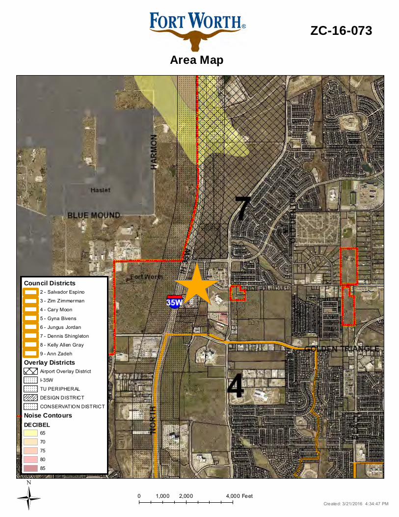
City Council Meeting Date: Council District 7 May 3, 2015
Continued Yes __ No _X_ Case Manager Stephen Murray Surplus Yes ___ No _X_ Council Initiated Yes ___ No _X_
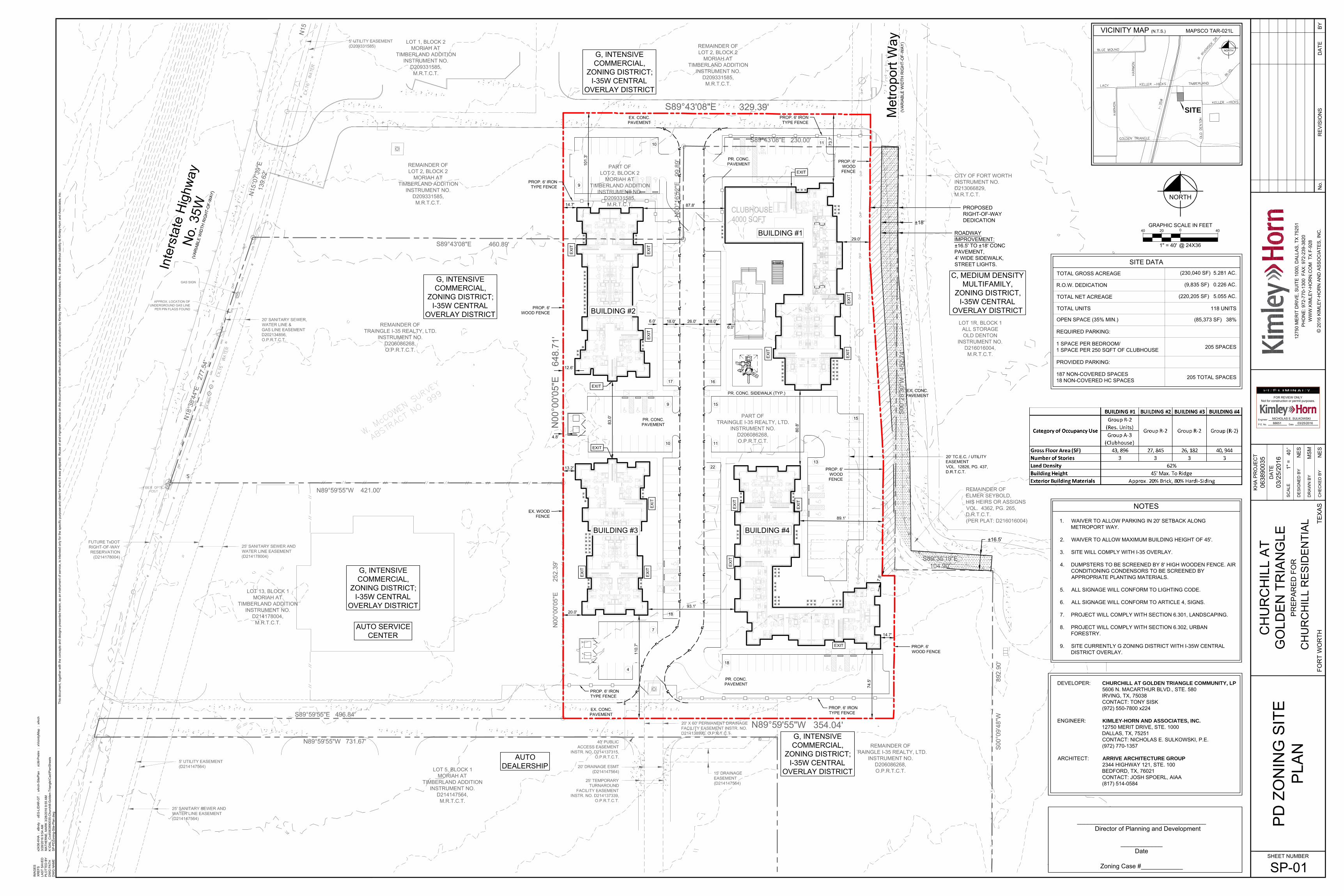
Owner / Applicant: Triangle I-35 Realty Site Location: 11200 IH 35 N. and 11228 Timberland Mapsco: 21GL Proposed Use: Multifamily Request: From: “G” Intensive Commercial/I-35 Overlay To: “PD/D” Planned Development for all uses in “D” High Density Multifamily with a
maximum of 118 units; site plan included/I-35 Overlay Land Use Compatibility: Requested change is compatible. Comprehensive Plan Consistency: Requested change is consistent Background: The property is located on Keller Hicks Rd. near the corner of Timberland. The applicant is proposing a zoning change from “G” Intensive Commercial to ““PD/D” Planned Development for all uses in “D” High Density Multifamily with a maximum of 118 units, site plan included. The proposed site is located within the growing IH 35 N/Alliance area. Several multifamily units were developed directly east of the site with additional sites planned to the northeast. Also, several commercial tracts are developing along I-35W. Additional multifamily will provide housing alternatives to many of the new employees within the area. An express bus stop is located roughly 1.5 miles along I-35 to the south. The applicant is developing to roughly 22 units per acre, which is less dense than the maximum of 24 units per acre in “D”. The applicant is also requesting two standard waivers and three waivers to the I-35 Overlay. The site has been reviewed by I-35 Overlay staff who has indicated that the waivers do not need to be reviewed by the UDC and can be provided through the site plan process. Zoning staff has requested comments relating to the appropriateness of the waivers. The property is not adjacent to I-35 and is expected to be blocked from view from I-35 by future commercial development in between. Standard
• Max height of 32 ft. (waiver required for 45 ft.) • 20 ft. setback along Metroport Way
Zoning Commission Recommendation: Approval by a vote of 9-0
Opposition: None submitted Support: None submitted
Page 2 of 4
o Parking prohibited (waiver required) Overlay
• 50 ft front yard setback (waiver required) • 25 ft. front yard paving setback along Metroport (waiver required) • Wood screening fence in Overlay (waiver required)
The site is located within the I-35 Overlay and will be required to comply with those standards. The southern boundary of the Alliance Airport Overlay Zone which restricts residential uses is located north of Keller Hicks Road and does not limit the uses on this property. Site Information:
Owner: Triangle I-35 Realty 303 West Wall Street, Suite 1500
Midland, TX 79701 Agent: Bradley E. Forslund Acreage: 5.88 acres Comprehensive Plan Sector: Far North Surrounding Zoning and Land Uses:
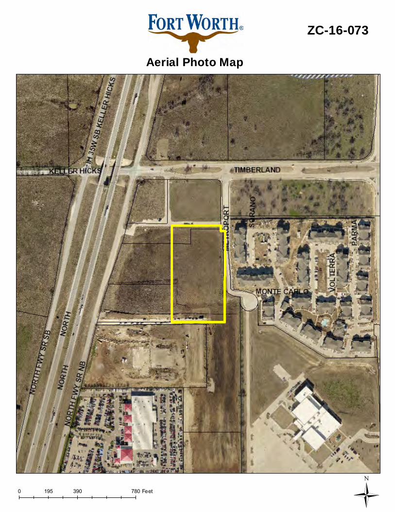
North “G” Intensive Commercial / vacant East “C” Medium Density Multifamily / multifamily South “G” Intensive Commercial / auto dealership West “G” Intensive Commercial / vacant
Recent Relevant Zoning and Platting History: Zoning History: ZC-11-110 “C” Medium Density Multifamily, east of the subject property, approved
11/2011 ZC-15-080, from “G” Intensive Commercial to “C” Medium Density Multifamily,
northeast of subject property; effective 6/16/15 Platting History: FS-11-181 Mansions at Timberland, east of the subject property
Transportation/Access
Street/Thoroughfare Existing Proposed In Capital
Improvements Plan (CIP)
Timberland Major Arterial Major Arterial No Keller Hicks Collector Collector No
Public Notification:
Organizations Notified North Fort Worth Alliance Streams And Valleys Inc Villages of Woodland Springs HOA Keller ISD Northwest Fort Worth Community Alliance Northwest ISD Trinity Habitat for Humanity
Not located within a registered Neighborhood Organization Site Plan Comments:
The site plan as submitted is not in general compliance with the Zoning Ordinance regulations. The deficiencies are:
1. 20 ft. setback along Metroport Way a. Parking prohibited (waiver required)
2. Provide note stating site will comply with I-35 overlay a. 50 ft front yard setback (waiver required) b. 25 ft. front yard paving setback along Metroport (waiver required) c. Wood screening fence in Overlay (waiver required)
3. Max height of 32 ft. (waiver required for 45 ft.) Compliance with the items noted above shall be reflected on the site plan.
Page 3 of 4
TPW Comments:
1. Traffic Impact Study - Submit a Traffic Impact Study (TIS) for TPW approval. The most recent study 3/25/15 does not include multi-family within the uses. A technical update of the TIA will be required in conjunction with the replat. FS-15-269 as it incorporates this portion of a lot.
2. Public Access Easement - Access easements shall comply with the requirements of Section 31-106 (Street Standards) I (Access Easement Design Standards (Public Access Easements, Reciprocal access Easements, Private Drives or Ways) of the Subdivision Ordinance. Access easements are privately maintained but constructed to city street standards that are open to unrestricted and irrevocable public access and serve two or more lots each having a minimum of 100 feet of frontage as their primary means of access. The proposed multi-family site includes a portion of a public access easement, however, does not provide the remaining portion of the lot to have public access achieved for it. Show how the public access easement to the south of the project will continue to connect back to Metroport.
3. Variable ROW - Show the full ROW widths for all existing streets. For streets having variable ROW, call out the ROW as “Variable” and give “Range” of the ROW. Show the widths of Metroport Way and the existing public access easements.
4. Gated Entrances (Ch. 31-107) - Gated entrances into secured areas must be designed in accordance with TPW’s “Traffic Engineering Design Standards and Policy Guidelines”. Provisions for an acceptable turnaround must be made. Provide details in IPRC plan set (single-family) or UR site plan (multi-family) for gates. All gates shall be equipped with a knox-box or other approved fire access apparatus that is reviewed and approved by the Fire Department. (Gates must be located 3 vehicle lengths from the ROW).
5. Sidewalks - Sidewalks and street lights are required for all public and private streets and public access easements as per City of Fort Worth Standards. Show the sidewalks along Metroport and the public pedestrian access easements proposed on the plat.
Platting Comments:
1. FYI--The property must be final platted prior to issuance of a building permit. 2. Cannot leave any remainders of existing final platted lots when platting this lot. Those
remainders would have to be included with the final plat. 3. Cannot final plat your property in phases unless the final plat is complying with an approved
preliminary plat. Otherwise a new preliminary plat would have to be approved prior to final platting the property in phases.
4. Since this project does not have direct access to a public or private street, then the only option is via a public access easement.
5. Since this project will have more than 100 units two points of access will be required. Both points of access will be for ingress and egress. One of them cannot simply be an emergency access.
Parks Comments: The Neighborhood and Community Park Dedication Policy will apply.
Fire Comments: 1. The 26' fire lane shown on this site plan will need to be named and platted for addressing and
identification requirements per the fire code. 2. Show the FDC connections for the buildings. FDC connections are required to be within 50’
of a fire apparatus access road (fire lane or street) and within 300’ of a fire hydrant. Building‘s FDC connect must comply with section 912 of the Fire Code
(Comments made by Platting (Subdivision Ordinance), Transportation/Public Works, Fire, Parks and Water Department staff cannot be waived through the Zoning Commission and City Council. Approval of the zoning site plan does not constitute the acceptance of conditions.) Development Impact Analysis:
1. Land Use Compatibility The applicant is proposing to bring approximately five acres of commercially zoned land to expand multifamily zoning in the area. Surrounding land uses vary with vacant land to the north and west, a large car lot the south, and multifamily the east.
Page 4 of 4
The proposed site is next to existing multifamily. The proposed use is also located between future commercial and the interstate, providing a buffer to single-family uses further east of Old Denton Rd. The location also is appropriate since the primary traffic flow will typically utilize the interstate and should provide a minimal traffic increase to the nearby single family uses. As a result, the proposed zoning is compatible at this location.
2. Comprehensive Plan Consistency The 2016 Comprehensive Plan designates the subject property as General Commercial. The requested zoning change is consistent with the following Comprehensive Plan policies:
• Locate multifamily units adjacent to collector streets, arterial streets, or rail transit stations to provide the increased level of transportation services necessary for the greater number of residents. (pg. 38)
• Separate incompatible land uses with buffers or transitional uses. Some land uses have attributes such as height, proportion, scale, operational characteristics, traffic generated, or appearance that may not be compatible with the attributes of other uses. (pg. 40)
Based on the conformance with the future land use map and policies stated above the proposed zoning is consistent with the Comprehensive Plan.
Attachments:
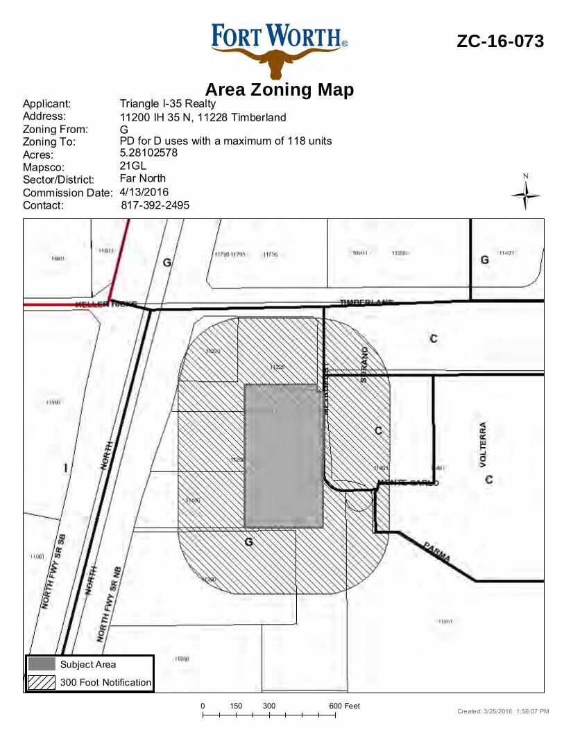
• Location Map • Area Zoning Map with 300 ft. Notification Area • Future Land Use Map • Aerial Photograph • Site Plan • Minutes from the Zoning Commission meeting
0 300 600150 Feet
Area Zoning Map
ZC-16-073
Applicant: Address:Zoning From:Zoning To:Acres:Mapsco:Sector/District:Commission Date:Contact:
Triangle I-35 Realty
21GL5.28102578PD for D uses with a maximum of 118 unitsG11200 IH 35 N, 11228 Timberland
817-392-24954/13/2016Far North
Created: 3/25/2016 1:56:07 PM
Subject Area
300 Foot Notification
Ü
0 2,000 4,0001,000 Feet
Area Map
ZC-16-073
Created: 3/21/2016 4:34:47 PMÜ
Council Districts2 - Salvador Espino
3 - Zim Zimmerman
4 - Cary Moon
5 - Gyna Bivens
6 - Jungus Jordan
7 - Dennis Shingleton
8 - Kelly Allen Gray
9 - Ann Zadeh
Overlay DistrictsAirport Overlay District
I-35W
TU PERIPHERAL
DESIGN DISTRICT
CONSERVATION DISTRICT
Noise ContoursDECIBEL
65
70
75
80
85
PD
ZO
NIN
G S
ITE
PLA
N
SP-01
0638
9003
5 NE
S
MS
M
NE
S
1" =
'40
This
doc
umen
t, to
geth
er w
ith th
e co
ncep
ts a
nd d
esig
ns p
rese
nted
her
ein,
as
an in
stru
men
t of s
ervi
ce, i
s in
tend
ed o
nly
for t
he s
peci
fic p
urpo
se a
nd c
lient
for w
hich
it w
as p
repa
red.
Reu
se o
f and
impr
oper
relia
nce
on th
is d
ocum
ent w
ithou
t writ
ten
auth
oriz
atio
n an
d ad
apta
tion
by K
imle
y-H
orn
and
Ass
ocia
tes,
Inc.
sha
ll be
with
out l
iabi
lity
to K
imle
y-H
orn
and
Ass
ocia
tes,
Inc.
BY
DA
TE
RE
VIS
ION
SN
o.D
ATE
SHEET NUMBER
CH
EC
KE
D B
Y
SC
ALE
DE
SIG
NE
D B
Y
DR
AW
N B
Y
KH
A P
RO
JEC
T
LAS
T S
AV
ED
3/28
/201
6 9:
54 A
MP
LOTT
ED
BY
MA
THE
RN
E, M
AR
K 3
/28/
2016
9:5
5 A
MD
WG
PA
THK
:\DA
L_C
ivil\
0638
9003
5-C
hurc
hill-
Gol
den-
Tria
ngle
\Cad
\Pla
nShe
ets
DW
G N
AM
ES
P-P
DZo
ning
-Site
-Pla
n.dw
g
Engineer
P.E. No. Date
Not for construction or permit purposes.FOR REVIEW ONLY
03/25/201688651NICHOLAS E. SULKOWSKI
CH
UR
CH
ILL
AT
GO
LDE
N T
RIA
NG
LEP
RE
PA
RE
D F
OR
CH
UR
CH
ILL
RE
SID
EN
TIA
L TEX
AS
FOR
T W
OR
TH©
201
6 K
IMLE
Y-H
OR
N A
ND
AS
SO
CIA
TES
, IN
C.
1275
0 M
ER
IT D
RIV
E, S
UIT
E 1
000,
DA
LLA
S, T
X 7
5251
PH
ON
E: 9
72-7
70-1
300
FA
X: 9
72-2
39-3
820
WW
W.K
IMLE
Y-H
OR
N.C
OM
TX
F-9
28
IMA
GE
SX
RE
FS
x24
36-K
HA
: x
Bnd
y :
oE
G-L
IDA
R-G
T :
xA
rch-
Site
Pla
n :
xU
til-P
relim
: x
Vic
inity
Map
: x
Arc
h
03/2
5/20
16
NORTH
GRAPHIC SCALE IN FEET040 20 40
1" = 40' @ 24X36
SITE DATA
TOTAL GROSS ACREAGE (230,040 SF) 5.281 AC.
R.O.W. DEDICATION (9,835 SF) 0.226 AC.
TOTAL NET ACREAGE (220,205 SF) 5.055 AC.
TOTAL UNITS 118 UNITS
OPEN SPACE (35% MIN.) (85,373 SF) 38%
REQUIRED PARKING:
1 SPACE PER BEDROOM/1 SPACE PER 250 SQFT OF CLUBHOUSE 205 SPACES
PROVIDED PARKING:
187 NON-COVERED SPACES18 NON-COVERED HC SPACES 205 TOTAL SPACES
VICINITY MAP (N.T.S.) MAPSCO TAR-021L
NORTH
SITE
1. WAIVER TO ALLOW PARKING IN 20' SETBACK ALONGMETROPORT WAY.
2. WAIVER TO ALLOW MAXIMUM BUILDING HEIGHT OF 45'.
3. SITE WILL COMPLY WITH I-35 OVERLAY.
4. DUMPSTERS TO BE SCREENED BY 8' HIGH WOODEN FENCE. AIRCONDITIONING CONDENSORS TO BE SCREENED BYAPPROPRIATE PLANTING MATERIALS.
5. ALL SIGNAGE WILL CONFORM TO LIGHTING CODE.
6. ALL SIGNAGE WILL CONFORM TO ARTICLE 4, SIGNS.
7. PROJECT WILL COMPLY WITH SECTION 6.301, LANDSCAPING.
8. PROJECT WILL COMPLY WITH SECTION 6.302, URBANFORESTRY.
9. SITE CURRENTLY G ZONING DISTRICT WITH I-35W CENTRALDISTRICT OVERLAY.
_____________________________________ Director of Planning and Development
____________Date
Zoning Case #____________
DEVELOPER: CHURCHILL AT GOLDEN TRIANGLE COMMUNITY, LP5606 N. MACARTHUR BLVD., STE. 580IRVING, TX, 75038CONTACT: TONY SISK(972) 550-7800 x224
ENGINEER: KIMLEY-HORN AND ASSOCIATES, INC.12750 MERIT DRIVE, STE. 1000DALLAS, TX, 75251CONTACT: NICHOLAS E. SULKOWSKI, P.E.(972) 770-1357
ARCHITECT: ARRIVE ARCHITECTURE GROUP2344 HIGHWAY 121, STE. 100BEDFORD, TX, 76021CONTACT: JOSH SPOERL, AIAA(817) 514-0584
NOTES
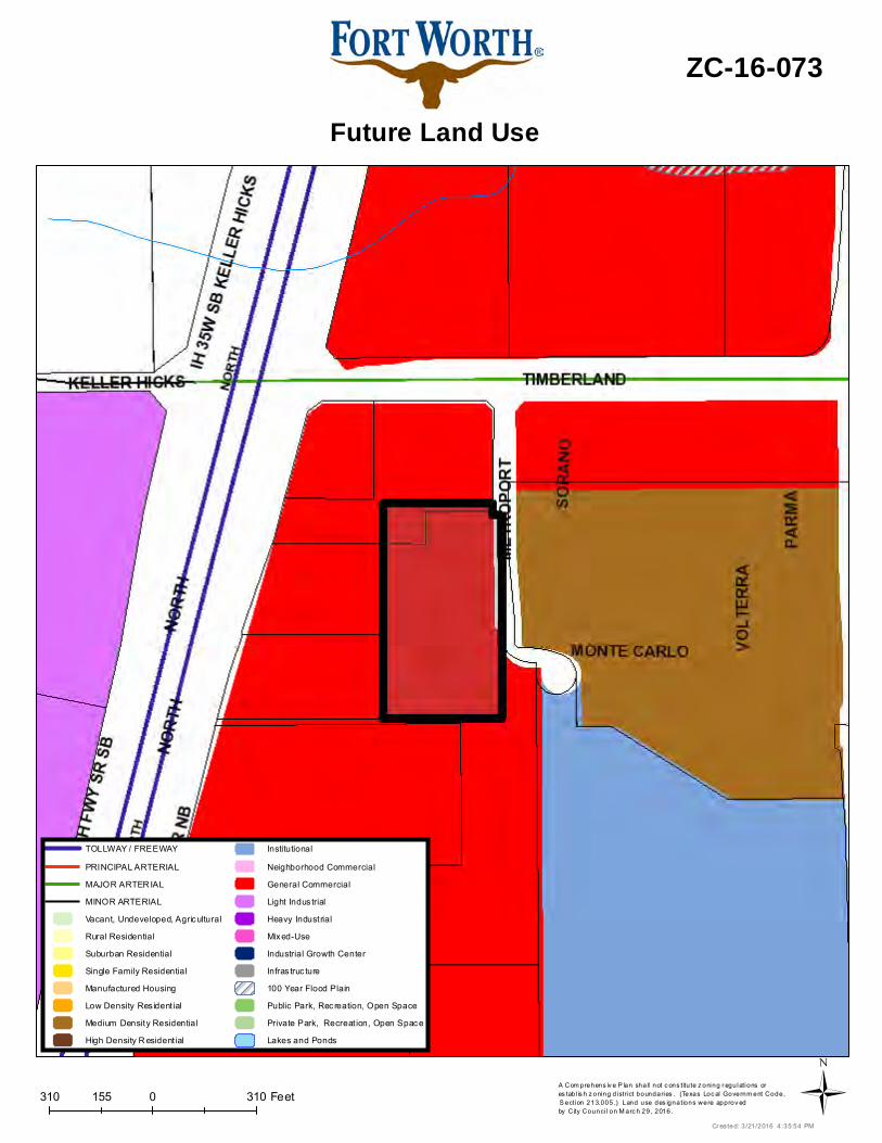
310 0 310155 FeetA Com prehens iv e P lan shall not c ons titu te z oning r egulations ores tab l is h z oning d istrict boundaries . (Texas Loc al Governm ent Code, S ection 213.005.) Land use des ignations were approv ed by City Counci l on M arc h 29, 2016.
Future Land Use
ZC-16-073
Cr eated: 3 /21/2016 4 :35:54 PM
TOLLWAY / FREEWAY
PRINCIPAL ARTERIAL
MAJOR ARTER IAL
MINOR ARTERIAL
Vacant, Undeveloped, Agricultural
Rural Residential
Suburban Residential
Single Family Residential
Manufactured Housing
Low Density Res ident ial
Medium Density Residential
High Density R esident ial
Institutional
Neighborhood Commercial
General Commercial
Light Indus trial
Heavy Industrial
Mixed-Use
Industrial Growth Center
Infras truc ture
100 Year Flood Plain
Public Park, Recreation, Open Space
Private Park, Recreat ion, Open Space
Lakes and Ponds
Ü
0 390 780195 Feet
Aerial Photo Map
ZC-16-073
Ü
Draft ZC Minutes (not verbatim) 4/13/16 Page 8
“PD/SU” Planned Development/Specific Use for a parking lot only with “MU-1” development standards and posted signage visible from all areas of the property disallowing any type of work on vehicles in the parking lot; site plan included Jim Schell, 500 W. 7th Street, Suite 600, Fort Worth, Texas representing Advance Auto Parts explained to the Commissioners they will be tearing down the existing building at 4054 E. Lancaster and building a new 6,600 sq. ft. auto parts retail store. They are rezoning this lot to PD/MU-1 with development standards in order to meet the required parking. Mr. Schell did mention there will be posted signage visible from the parking lot disallowing any work in the parking lot. They are requesting a waiver to the screening requirement for the parking lot. Ms. Burghdoff explained the parking along E. Lancaster would need to be screened. Ms. Murphy said they would have to screen the parking lot along Chicago either with a four ft. screening fence with berm/bushes/shrubs. Mr. Schell said they will relocate the dumpster and move it further back to the east and not request the waiver. He also said if they can provide 28 spaces instead of 32 they could comply. Ms. Conlin mentioned they do not want the screening fence to go all the way out to Chicago, it needs to be moved back in line with the existing house. Ms. Burghdoff mentioned the parking lot needs to be screened from the neighbor. Ms. Burghdoff said it is about a 25 ft. setback. Ms. Conlin asked if he knew what the building would look like. Mr. Schell said no he did not. Ms. Conlin said the neighborhood had not been contacted and would he have someone reach out to them so they can be a part of this. Motion: Following brief discussion, Ms. Conlin recommended Approval as Amended of the request to move the dumpster to the east, maximum of 28 parking spaces, and move fence to 25 ft. setback, seconded by Mr. Cockrell. The motion carried unanimously 9-0. 9. ZC-16-073 Triangle I-35 Realty LTD (CD 7) - 11200 IH 35 N. and 11228 Timberland (William McGowan Survey, Abstract No. 999, 5.28 Acres): from “G” Intensive Commercial/I-35 Overlay to “PD/D” Planned Development for all uses in “D” High Density Multifamily with a maximum of 118 units; site plan included/I-35 Overlay Tony Sisk, 5605 North McArthur Boulevard, Suite 580, Los Colinas, Texas representing Triangle I-35 Realty explained to the Commissioners they are requesting the zoning change to add 118 multifamily units. They are requesting waivers for parking and setbacks to allow for a more urban type development. Motion: Following brief discussion, Mr. Northern recommended Approval of the request, seconded by Mr. Flores. The motion carried unanimously 9-0. 10. ZC-16-074 Ridglea Baptist Church (CD 3) – 6037 IH West Freeway/Calmont Avenue (Chamberlain Arlington Heights, Block 3, Lot 1R, 1.42 Acres): from “B” Two-Family to “E” Neighborhood Commercial