Embed Size (px)
Citation preview
Zone-Based Update Strategy for Location based
Services (LBS)
Suleiman Almasri1, Ziad Hunaiti1, Eliamani Sedoyeka
1 and Wamadeva
Balachandran2
1 Faculty of Science and Technology, Anglia Ruskin University, Chelmsford, UK
{s.almasri,z.hunaiti,e.sedoyeka}@anglia.ac.uk
2 Deptartment of Systems Engineering, Brunel University, Uxbridge, UK
Abstract. Location-based service (LBS) is one of the most important
applications related to GIS. In the past few years, there has been a rapid
expansion of activities in LBS providing pedestrians with easy access to useful
information whilst travelling from one place to another. LBS systems use the
power of mobile networks to locate a user and provide data and services based
on the location they are in. In view of the fact that the volume of this
information is huge, this paper presents a new database update mechanism
which will enable improvement of performance of the service provided by LBS
Systems. Such mechanism will reduce the usage of network bandwidth which
will contribute in minimising the power consumption of the user’s device
(Mobile Smartphone, PDA …etc.). This is because the mobile device receives
less information and avoids uploading any superfluous data.
Keywords: Location Based Services (LBS), Mobile GIS.
1 Introduction
The rapid development in mobile telecommunications and satellite navigation has
resulted in a birth of LBS, a new system that combines these two main technologies
[1]. LBS system in its basic architecture is a mobile device with satellite navigation
receiver (GPS) and mobile network interface connected over wireless networks to the
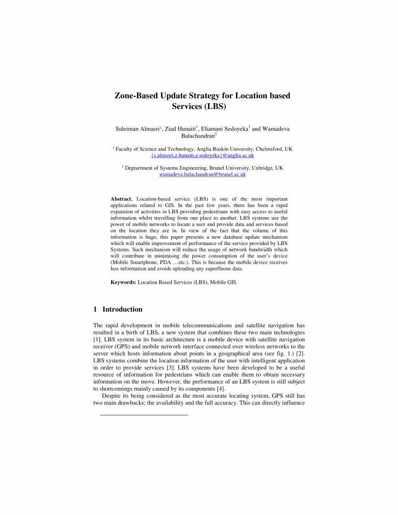
server which hosts information about points in a geographical area (see fig. 1.) [2].
LBS systems combine the location information of the user with intelligent application
in order to provide services [3]. LBS systems have been developed to be a useful
resource of information for pedestrians which can enable them to obtain necessary
information on the move. However, the performance of an LBS system is still subject
to shortcomings mainly caused by its components [4].
Despite its being considered as the most accurate locating system, GPS still has
two main drawbacks; the availability and the full accuracy. This can directly influence
the overall performance of any LBS system in particular within urban environments
[5]. Mobile device is the user gateway to access information, however, several
limitations are acknowledged: memory size, battery lifetime and processor
capabilities. Therefore, these three factors have a direct impact on LBS systems [6].
GIS database server is the main container which hosts all information to be accessed
by user’s mobile device. It is essential that the database should be managed and
accessed in an efficient way, otherwise unnecessary processing time and delay might
occur which can contribute in reducing the efficiency of the whole LBS system
[7][8][9]. Mobile wireless network enables data to be transferred between LBS server
and the end user’s mobile device. This communication channel suffers from lack in
bandwidth, particularly when many users are using the mobile network [10].
Therefore, minimizing the amount of data to be transferred over the mobile network
can significantly assist in minimizing delay and packet loss, which can directly
enhance the performance of LBS system.
Addressing the mentioned problems will enhance the efficiency of LBS systems.
Therefore, this paper is tackling the problems through proposing a new mechanism
for managing the GIS database by dividing it into a number of geographical zones. In
such a way, the amount of data to be loaded to the end-user mobile device will be
reduced, which will have a positive impact on the network, mobile device and the
database. Traditionally, LBS system updates the end users through sending large
information associated with a large geographical area. Nowadays, to enhance the
efficiency and better manage the huge database, LBS system is being developed to
use zone-based strategy, i.e. smaller geographical areas [11][12].
Fig. 1. General LBS Architecture and it problems
In this paper, zone-based update strategy has been utilised in order to investigate its
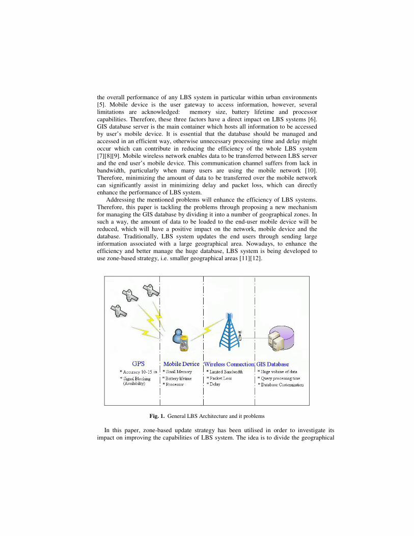
impact on improving the capabilities of LBS system. The idea is to divide the geographical
information and its database into two types of zones; Macro-zones and Micro-zones. Macro-
zone is a large geographical area, for instance a town. It is also divided into smaller areas
which are called Micro-zones (see fig. 2).
The Macro-zone is a vector map. In the Vector maps mode, the spatial objects are
referenced to a coordinate system, which consists of coordinates, a datum, and a projection.
Spatial objects might be one of the following; a single point, which might represent a person,
a vehicle or a Pint of Interest (PoI). Or a straight line which is modeled by a link between
two points. Or a polyline which is symbolized by a linked list of points (vertices). Or a
polygon which is a closed polyline, a polygon is said to be convex if it has no internal angles
greater than 180 ۫, otherwise it is a concave [1]. Moreover, this Macro-Zone contains detailed
information about the micro-zone which the user is located at, and adjacent micro-zones.
The Micro-Zone is a raster map. The raster mode is very similar to a bitmap picture,
which consists of a grid of pixels ordered in a number of rows and columns. The more
number of pixels in the grid is the more quality of raster data [1]. The size of a micro-zone is
to be within the walking distance of a pedestrian; for example, a distance of 2 Km. Each
micro-zone will be assigned a known update point in order to ease adding any information
associated with it. Also each micro-zone will have its unique ID and borders that will enable
the system to automatically download the data associated to this zone as the pedestrian
approaches it. This will be done either automatically or manually by asking the user to
confirm the download process.
Fig. 2. Zone based Mechanism
2 Initial Implementation and Evaluation
In order to evaluate the proposed mechanism, a simplified scenario was implemented
using a master map of Chelmsford UK, and Geomedia Professional GIS system with
mobile expansion for GPS (fig. 3). This software tool was installed on a laptop
connected to the internet via HSDPA connection, and connected to GPS system via
Holox GPS receiver [13]. During the implementation, Chelmsford vector map was
considered as macro-zone and divided into cluster of micro-zones with defined
borders. The system was configured to ask the users if they want to upload
information when they are getting closer to the adjacent micro-zone, for example,
10m. Moreover, the user can accept or reject the message. If he/she accepts it, then an
internet link is established to a remote server to simulate LBS server.
In order to test the Zone-based update Mechanism on the real world, the researcher
has used Toshiba Equium laptop that represents the mobile end user. This laptop was
connected to a GPS receiver (Holox BT321) via Bluetooth in order to fix the end user
physical location. Furthermore, Geomedia Professional software was used as a GIS
tool to do the implementation. Geomedia receives the NMEA GPS message string
from the GPS receiver and present the location on the Chelmsford master map.
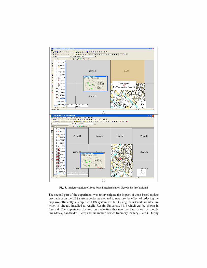
Trial was conducted by the researcher to demonstrate the process. The GPS
receiver fix the location of the user which is then matched and placed on the map by
Geomedia professional. As shown in fig. 3 (a), the user started to move while the GPS
kept updating its new location. By approaching the border of new micro-zone, the
system has generated an automatic message asking the user to confirm whether he
wants to upload the new zone data (fig. 3 (b)). Once the user has accepted the upload
message, the system automatically supplied the new micro-zone data as shown in fig.
3 (c).
(a)
(b)
(c)
Fig. 3. Implementation of Zone-based mechanism on GeoMedia Professional
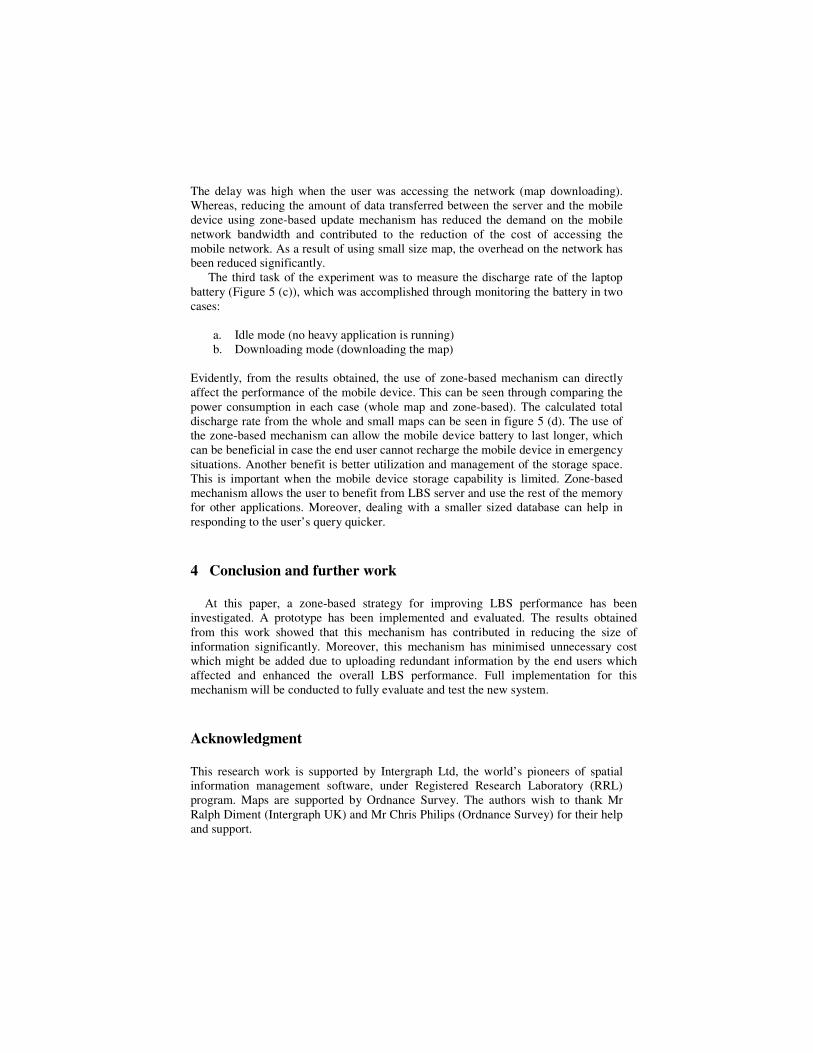
The second part of the experiment was to investigate the impact of zone-based update
mechanism on the LBS system performance, and to measure the effect of reducing the
map size efficiently, a simplified LBS system was built using the network architecture
which is already installed at Anglia Ruskin University [11] which can be shown in
figure 4. The experiment focused on evaluating this new mechanism on the mobile
link (delay, bandwidth …etc) and the mobile device (memory, battery …etc.). During
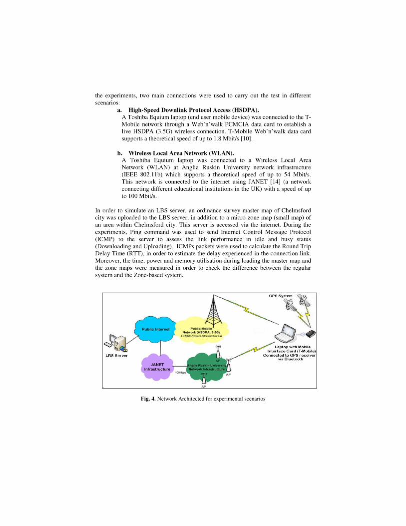
the experiments, two main connections were used to carry out the test in different
scenarios:
a. High-Speed Downlink Protocol Access (HSDPA).
A Toshiba Equium laptop (end user mobile device) was connected to the T-
Mobile network through a Web’n’walk PCMCIA data card to establish a
live HSDPA (3.5G) wireless connection. T-Mobile Web’n’walk data card
supports a theoretical speed of up to 1.8 Mbit/s [10].
b. Wireless Local Area Network (WLAN). A Toshiba Equium laptop was connected to a Wireless Local Area
Network (WLAN) at Anglia Ruskin University network infrastructure
(IEEE 802.11b) which supports a theoretical speed of up to 54 Mbit/s.
This network is connected to the internet using JANET [14] (a network
connecting different educational institutions in the UK) with a speed of up
to 100 Mbit/s.
In order to simulate an LBS server, an ordinance survey master map of Chelmsford
city was uploaded to the LBS server, in addition to a micro-zone map (small map) of
an area within Chelmsford city. This server is accessed via the internet. During the
experiments, Ping command was used to send Internet Control Message Protocol
(ICMP) to the server to assess the link performance in idle and busy status
(Downloading and Uploading). ICMPs packets were used to calculate the Round Trip
Delay Time (RTT), in order to estimate the delay experienced in the connection link.
Moreover, the time, power and memory utilisation during loading the master map and
the zone maps were measured in order to check the difference between the regular
system and the Zone-based system.
Fig. 4. Network Architected for experimental scenarios
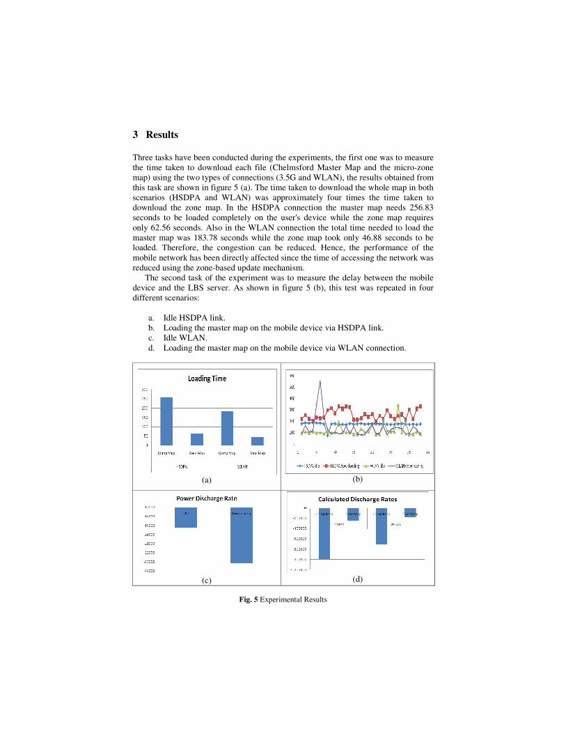
3 Results
Three tasks have been conducted during the experiments, the first one was to measure
the time taken to download each file (Chelmsford Master Map and the micro-zone
map) using the two types of connections (3.5G and WLAN), the results obtained from
this task are shown in figure 5 (a). The time taken to download the whole map in both
scenarios (HSDPA and WLAN) was approximately four times the time taken to
download the zone map. In the HSDPA connection the master map needs 256.83
seconds to be loaded completely on the user's device while the zone map requires
only 62.56 seconds. Also in the WLAN connection the total time needed to load the
master map was 183.78 seconds while the zone map took only 46.88 seconds to be
loaded. Therefore, the congestion can be reduced. Hence, the performance of the
mobile network has been directly affected since the time of accessing the network was
reduced using the zone-based update mechanism.
The second task of the experiment was to measure the delay between the mobile
device and the LBS server. As shown in figure 5 (b), this test was repeated in four
different scenarios:
a. Idle HSDPA link.
b. Loading the master map on the mobile device via HSDPA link.
c. Idle WLAN.
d. Loading the master map on the mobile device via WLAN connection.
(a)
(b)
(c)
(d)
Fig. 5 Experimental Results
The delay was high when the user was accessing the network (map downloading).
Whereas, reducing the amount of data transferred between the server and the mobile
device using zone-based update mechanism has reduced the demand on the mobile
network bandwidth and contributed to the reduction of the cost of accessing the
mobile network. As a result of using small size map, the overhead on the network has
been reduced significantly.
The third task of the experiment was to measure the discharge rate of the laptop
battery (Figure 5 (c)), which was accomplished through monitoring the battery in two
cases:
a. Idle mode (no heavy application is running)
b. Downloading mode (downloading the map)
Evidently, from the results obtained, the use of zone-based mechanism can directly
affect the performance of the mobile device. This can be seen through comparing the
power consumption in each case (whole map and zone-based). The calculated total
discharge rate from the whole and small maps can be seen in figure 5 (d). The use of
the zone-based mechanism can allow the mobile device battery to last longer, which
can be beneficial in case the end user cannot recharge the mobile device in emergency
situations. Another benefit is better utilization and management of the storage space.
This is important when the mobile device storage capability is limited. Zone-based
mechanism allows the user to benefit from LBS server and use the rest of the memory
for other applications. Moreover, dealing with a smaller sized database can help in
responding to the user’s query quicker.
4 Conclusion and further work
At this paper, a zone-based strategy for improving LBS performance has been
investigated. A prototype has been implemented and evaluated. The results obtained
from this work showed that this mechanism has contributed in reducing the size of
information significantly. Moreover, this mechanism has minimised unnecessary cost
which might be added due to uploading redundant information by the end users which
affected and enhanced the overall LBS performance. Full implementation for this
mechanism will be conducted to fully evaluate and test the new system.
Acknowledgment
This research work is supported by Intergraph Ltd, the world’s pioneers of spatial
information management software, under Registered Research Laboratory (RRL)
program. Maps are supported by Ordnance Survey. The authors wish to thank Mr
Ralph Diment (Intergraph UK) and Mr Chris Philips (Ordnance Survey) for their help
and support.

References
1. Kubber A.: Location Based Services, ISBN: 0470092319, John Wiley and Sons, Published
October 2005
2. Almasri S., Hunaiti Z.: A New System Design to Enhance Location-Based Services and
Positioning Accuracy. Accepted In: International Conference on e-Business ICE-B,
Barcelona-Spain (2007)
3. Brimicombe A., Li Y.:Mobile Space-Time Envelopes for Location-Based Services. In:
Transactions in GIS, 10 (1), pp. 5-23 (2006)
4. Mountain DM., Raper JF.: Location-based services in remote areas. In: AGI conference at
GeoSolutions, B05.3, (2002)
5. Theiss A., David C.,Yuan C.: Global Positioning Systems: an analysis of applications,
current development and future implementations. In: Computer Standards & Interfaces.
Vol. 27, pp. 89-100, January (2005)
6. ANDERSON P., BLACKWOOD A.: Mobile and PDA Technologies and their future use in
education. In: JISC Technology & Standards Watch. Bristol, UK(2004)
7. Artem G.: Management of Geographic Information in Mobile Environments. In:
Department of Computer Science and Information Systems, University of Jyväskylä:
Jyväskylä (2000)
8. Reinhardt W.: Concept of GIS and location based services for mountaineers. Proceedings
of GI in Europe. In: 4th AGILE conference on GI Science. 19-21. Brno, Czech Republic
(2001)
9. Renault S., Le Meur A., Meizel D.: GPS/GIS localization for management of vision
referenced navigation in urban environments. In: Intelligent Transportation Systems, IEEE,
pp. 608-613 (2005)
10. Sedoyeka E., Almasri S., Rahman A., Hunaiti Z.: HSDPA wireless broadband Link
Performance. In: PGNet Liverpool john moores 8th annual conference. Liverpool, UK
(2007)
11. Weiss D., Krämer I., Treu G., Küpper A.: Zone Services --- An Approach for Location-
based Data Collection. In: Proceedings of Third IEEE International Workshop on Mobile
Commerce and Services (WMCS'06), IEEE Computer Society, pp. 504-511. San Francisco,
USA (2006)
12. Almasri S., Sedoyeka E., Alnabhan M., Hunaiti Z.: Location-based services enhancement
using Zone-based Up-date Mechanism. In: PGNet Liverpool John Moores 8th annual
conference. Liverpool, UK (2007)
13. Hunaiti Z.: Testbed for 21st Century Wireless Networks Applications. In: Fourth IEEE,
International Conference on Wireless and Optical Communications Networks: Next
Generation Networks, Singapore Singapore (2007)
14. The UK's education and research network (JANET), [internet accessed on 20 April 2007],
http://www.ukerna.ac.uk