Embed Size (px)
Citation preview
CONSERVATION INFORMATICS GROUP UNIVERSITY OF HELSINKI AIM AND PURPOSE
Species, habitats and ecosystems are threat-ened by habitat loss, fragmentation and cli-mate change. Resources available for conser-vation must be used efficiently to combat such threats. Zonation is a freely available framework and software for conservation resource allocation. Zonation produces a spatial priority ranking which can be used to inform conservation de-cision making. Zonation allows a direct link from high-resolution GIS data to habitat mod-elling to conservation prioritization. Analyses doable using Zonation include
EXAMPLE Expanding the conservation area network of the Finnish Forest and Park Service.
SOME ZONATION APPLICATIONS
FEATURES
Identification of conservation landscapes for butterflies in UK Moilanen, Franco, Early, Fox, Wintle & Thomas 2005. Proc. R. Soc. B, 272: 1885-1891.
In collaboration with:
Finnish Forest and Park Service Finnish Environment Institute Finnish Forest Research Institute
Contact information: Atte Moilanen email: [email protected] Department of Biological and Environmental Sciences Tel: +358 9 191 57753 (work) PO Box 65 (Viikinkaari 1) +358 50 3388550 (mobile) FI-00014 University of Helsinki www: http://www.helsinki.fi/science/metapop
1
2
3
4
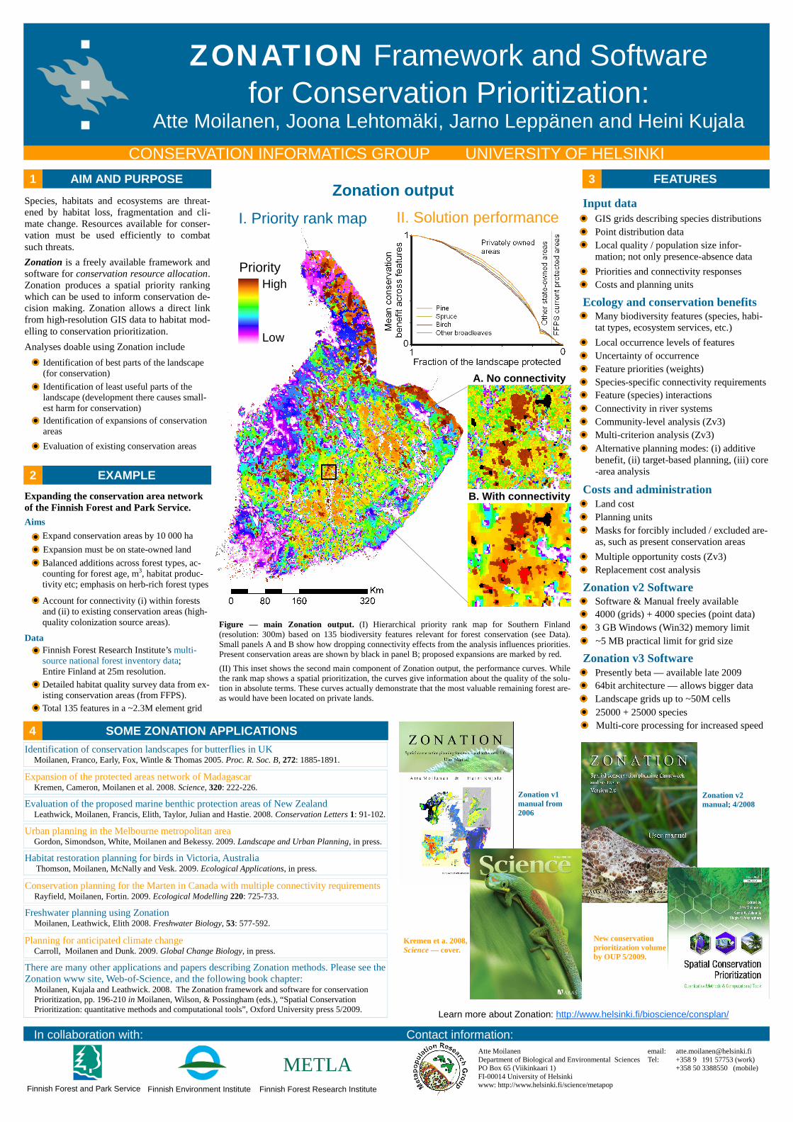
Figure — main Zonation output. (I) Hierarchical priority rank map for Southern Finland (resolution: 300m) based on 135 biodiversity features relevant for forest conservation (see Data). Small panels A and B show how dropping connectivity effects from the analysis influences priorities. Present conservation areas are shown by black in panel B; proposed expansions are marked by red.
Learn more about Zonation: http://www.helsinki.fi/bioscience/consplan/
Expand conservation areas by 10 000 ha
Balanced additions across forest types, ac-counting for forest age, m3, habitat produc-tivity etc; emphasis on herb-rich forest types
Account for connectivity (i) within forests and (ii) to existing conservation areas (high-quality colonization source areas).
Data Finnish Forest Research Institute’s multi-source national forest inventory data; Entire Finland at 25m resolution. Detailed habitat quality survey data from ex-isting conservation areas (from FFPS).
Many biodiversity features (species, habi-tat types, ecosystem services, etc.)
METLA
ZONATION Framework and Software for Conservation Prioritization:
Atte Moilanen, Joona Lehtomäki, Jarno Leppänen and Heini Kujala
Aims
Expansion must be on state-owned land
Identification of best parts of the landscape (for conservation)
Identification of expansions of conservation areas
Identification of least useful parts of the landscape (development there causes small-est harm for conservation)
Evaluation of existing conservation areas
Ecology and conservation benefits
Multi-criterion analysis (Zv3)
Local occurrence levels of features
Species-specific connectivity requirements
Feature priorities (weights)
Uncertainty of occurrence
Feature (species) interactions
Connectivity in river systems
Community-level analysis (Zv3)
Masks for forcibly included / excluded are-as, such as present conservation areas
Costs and administration Land cost
Multiple opportunity costs (Zv3)
Planning units
Replacement cost analysis
Zonation v2 Software
4000 (grids) + 4000 species (point data)
3 GB Windows (Win32) memory limit
~5 MB practical limit for grid size
Software & Manual freely available
Zonation v3 Software
64bit architecture — allows bigger data
Landscape grids up to ~50M cells
25000 + 25000 species
Presently beta — available late 2009
Multi-core processing for increased speed
Local quality / population size infor-mation; not only presence-absence data
Input data GIS grids describing species distributions
Priorities and connectivity responses
Point distribution data
Costs and planning units
Priority High
Low
A. No connectivity
B. With connectivity
II. Solution performance I. Priority rank map
Zonation output
Alternative planning modes: (i) additive benefit, (ii) target-based planning, (iii) core-area analysis
Zonation v1 manual from 2006
Zonation v2 manual; 4/2008
Kremen et a. 2008, Science — cover.
New conservation prioritization volume by OUP 5/2009.
Expansion of the protected areas network of Madagascar Kremen, Cameron, Moilanen et al. 2008. Science, 320: 222-226.
Evaluation of the proposed marine benthic protection areas of New Zealand Leathwick, Moilanen, Francis, Elith, Taylor, Julian and Hastie. 2008. Conservation Letters 1: 91-102.
Urban planning in the Melbourne metropolitan area Gordon, Simondson, White, Moilanen and Bekessy. 2009. Landscape and Urban Planning, in press.
Habitat restoration planning for birds in Victoria, Australia Thomson, Moilanen, McNally and Vesk. 2009. Ecological Applications, in press.
Conservation planning for the Marten in Canada with multiple connectivity requirements Rayfield, Moilanen, Fortin. 2009. Ecological Modelling 220: 725-733.
Freshwater planning using Zonation Moilanen, Leathwick, Elith 2008. Freshwater Biology, 53: 577-592.
Planning for anticipated climate change Carroll, Moilanen and Dunk. 2009. Global Change Biology, in press.
There are many other applications and papers describing Zonation methods. Please see the Zonation www site, Web-of-Science, and the following book chapter: Moilanen, Kujala and Leathwick. 2008. The Zonation framework and software for conservation Prioritization, pp. 196-210 in Moilanen, Wilson, & Possingham (eds.), “Spatial Conservation Prioritization: quantitative methods and computational tools”, Oxford University press 5/2009.
Total 135 features in a ~2.3M element grid
(II) This inset shows the second main component of Zonation output, the performance curves. While the rank map shows a spatial prioritization, the curves give information about the quality of the solu-tion in absolute terms. These curves actually demonstrate that the most valuable remaining forest are-as would have been located on private lands.