Embed Size (px)
Citation preview
International Virtual Aviation Organisation
June 2019 / Rev 7
ZAGREB FIR
SECTOR MANUAL
FOR SIMULATION PURPOSES ONLY
7
International Virtual Aviation Organisation
June 2019 / Rev 7
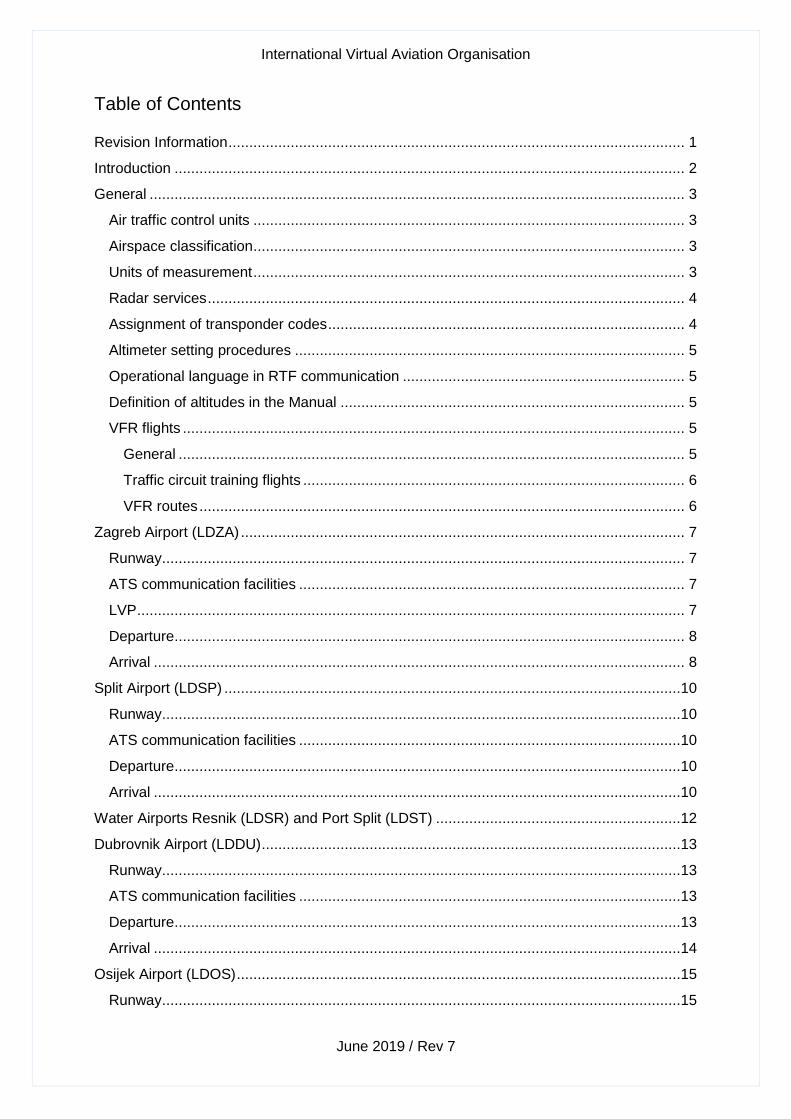
Table of Contents
Revision Information .............................................................................................................. 1
Introduction ........................................................................................................................... 2
General ................................................................................................................................. 3
Air traffic control units ........................................................................................................ 3
Airspace classification ........................................................................................................ 3
Units of measurement ........................................................................................................ 3
Radar services ................................................................................................................... 4
Assignment of transponder codes ...................................................................................... 4
Altimeter setting procedures .............................................................................................. 5
Operational language in RTF communication .................................................................... 5
Definition of altitudes in the Manual ................................................................................... 5
VFR flights ......................................................................................................................... 5
General .......................................................................................................................... 5
Traffic circuit training flights ............................................................................................ 6
VFR routes ..................................................................................................................... 6
Zagreb Airport (LDZA) ........................................................................................................... 7
Runway .............................................................................................................................. 7
ATS communication facilities ............................................................................................. 7
LVP .................................................................................................................................... 7
Departure ........................................................................................................................... 8
Arrival ................................................................................................................................ 8
Split Airport (LDSP) ..............................................................................................................10
Runway .............................................................................................................................10
ATS communication facilities ............................................................................................10
Departure ..........................................................................................................................10
Arrival ...............................................................................................................................10
Water Airports Resnik (LDSR) and Port Split (LDST) ...........................................................12
Dubrovnik Airport (LDDU) .....................................................................................................13
Runway .............................................................................................................................13
ATS communication facilities ............................................................................................13
Departure ..........................................................................................................................13
Arrival ...............................................................................................................................14
Osijek Airport (LDOS) ...........................................................................................................15
Runway .............................................................................................................................15
International Virtual Aviation Organisation
June 2019 / Rev 7
ATS communication facilities ............................................................................................15
Departure ..........................................................................................................................15
Arrival ...............................................................................................................................15
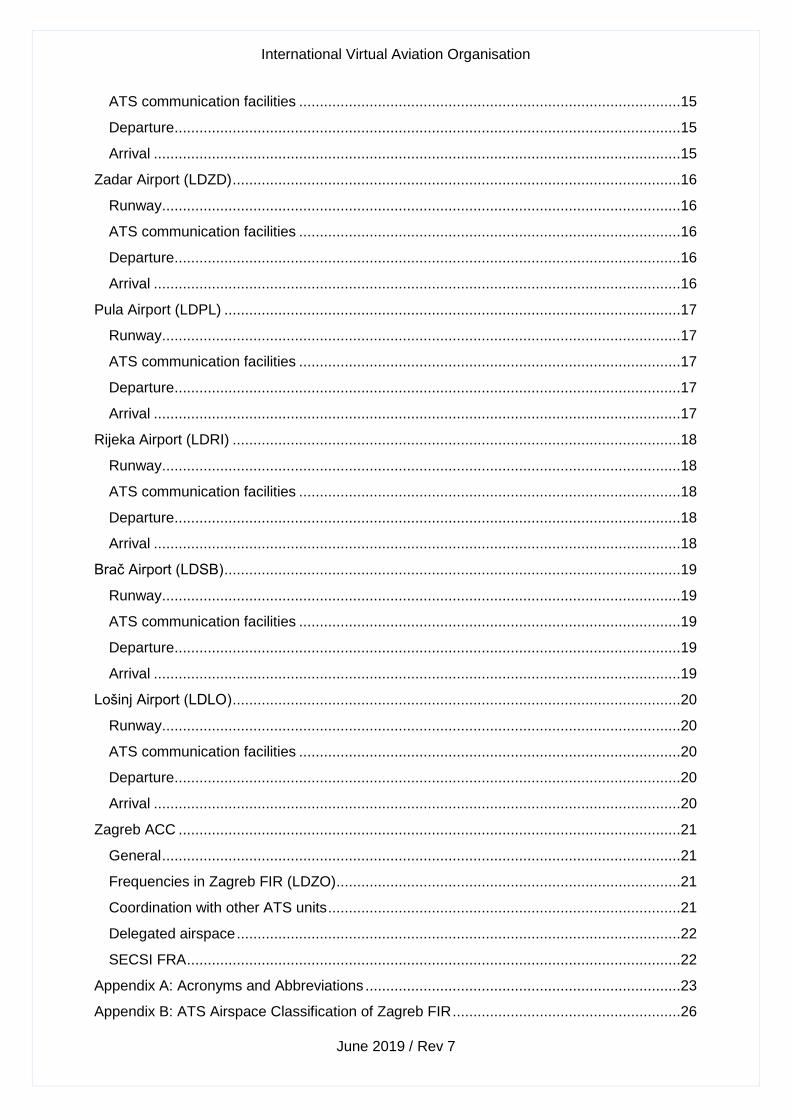
Zadar Airport (LDZD) ............................................................................................................16
Runway .............................................................................................................................16
ATS communication facilities ............................................................................................16
Departure ..........................................................................................................................16
Arrival ...............................................................................................................................16
Pula Airport (LDPL) ..............................................................................................................17
Runway .............................................................................................................................17
ATS communication facilities ............................................................................................17
Departure ..........................................................................................................................17
Arrival ...............................................................................................................................17
Rijeka Airport (LDRI) ............................................................................................................18
Runway .............................................................................................................................18
ATS communication facilities ............................................................................................18
Departure ..........................................................................................................................18
Arrival ...............................................................................................................................18
Brač Airport (LDSB) ..............................................................................................................19
Runway .............................................................................................................................19
ATS communication facilities ............................................................................................19
Departure ..........................................................................................................................19
Arrival ...............................................................................................................................19
Lošinj Airport (LDLO) ............................................................................................................20
Runway .............................................................................................................................20
ATS communication facilities ............................................................................................20
Departure ..........................................................................................................................20
Arrival ...............................................................................................................................20
Zagreb ACC .........................................................................................................................21
General .............................................................................................................................21
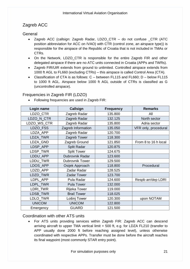
Frequencies in Zagreb FIR (LDZO) ...................................................................................21
Coordination with other ATS units .....................................................................................21
Delegated airspace ...........................................................................................................22
SECSI FRA .......................................................................................................................22
Appendix A: Acronyms and Abbreviations ............................................................................23
Appendix B: ATS Airspace Classification of Zagreb FIR .......................................................26

International Virtual Aviation Organisation
June 2019 / Rev 7
Appendix C: SECSI Free Route Airspace .............................................................................27

International Virtual Aviation Organisation
June 2019 / Rev 7
INTENTIONALLY BLANK
International Virtual Aviation Organisation
For simulation purposes only 1
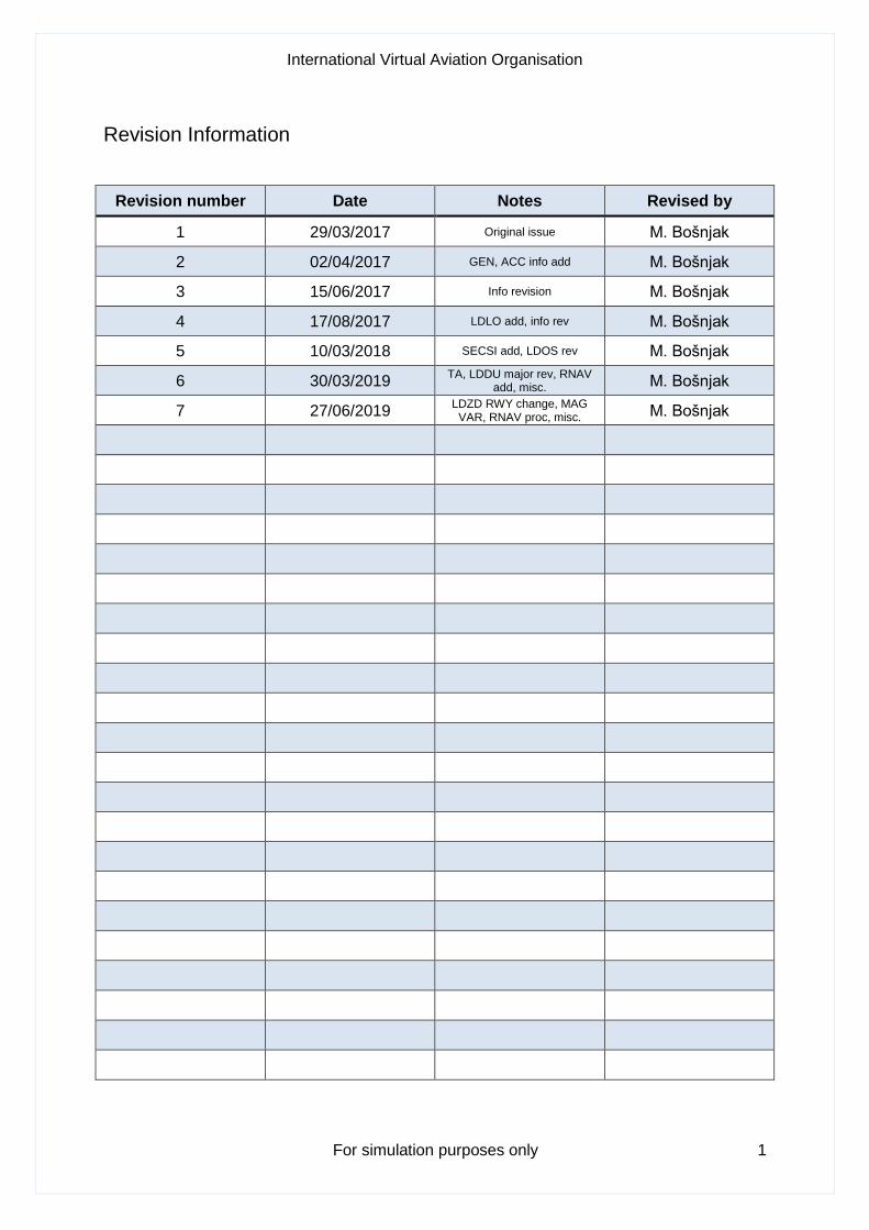
Revision Information
Revision number Date Notes Revised by
1 29/03/2017 Original issue M. Bošnjak
2 02/04/2017 GEN, ACC info add M. Bošnjak
3 15/06/2017 Info revision M. Bošnjak
4 17/08/2017 LDLO add, info rev M. Bošnjak
5 10/03/2018 SECSI add, LDOS rev M. Bošnjak
6 30/03/2019 TA, LDDU major rev, RNAV
add, misc. M. Bošnjak
7 27/06/2019 LDZD RWY change, MAG
VAR, RNAV proc, misc. M. Bošnjak
International Virtual Aviation Organisation
For simulation purposes only 2
Introduction
This manual is intended to be used by air traffic controllers on the IVAO network (hereinafter
the Network) when controlling in Zagreb Flight Information Region (LDZO FIR). The manual
provides information regarding operating procedures and standard practices in Croatian
airspace.
Controllers are expected to follow IVAO Rules and Regulations at all times so as to create a
comfortable, efficient and fun environment on the Network for themselves and for the pilots.
Moreover, controllers must have sufficient knowledge in order for them to control a certain
position on the Network. Knowledge of the Manual and Croatia AIP will be checked during
practical ATC exams in Croatian Division.
Some ATC positions may be restricted by the Facility Rating Assignment system (FRA) in
order to maintain controller's proficiency level. Controllers are not allowed to connect on the
FRA restricted position if their rating is below the requested one. You can check active FRA
restrictions on the main IVAO website under the Controllers tab.
All training documentation for controllers on the Network can be found on these links:
Student controller documentation (AS1-AS3)
Aerodrome controller documentation (ADC)
Approach controller documentation (APC)
Area centre controller documentation (ACC)
Senior controller documentation (SEC)
Real-life documentation regarding phraseology in Croatia is provided by the HKZP
(Crocontrol) and it supersedes phraseology examples published by the Network:
Voice communication procedures in Croatia (opens in PDF format)
Real-life charts and AIP information are provided by the HKZP (Crocontrol); controllers are
required to familiarise themselves with the information provided before connecting to the
Network as an active ATC position in Croatia:
Croatia AIP
VFR Manual Croatia
International Virtual Aviation Organisation
For simulation purposes only 3
General
Air traffic control units
• Following units exist in Zagreb FIR:
ground GND (LDZA only), tower TWR, approach APP, area centre control ACC
• Following ATC units are manned by one person (one frequency):
LDOS TWR/APP – Osijek Tower/Approach frequency is 118.800 (procedural control). On the
Network LDOS APP unit is responsible for TWR/APP service at LDOS.
NOTE: Rijeka and Lošinj arrivals and departures shall be handled by LDPL APP.
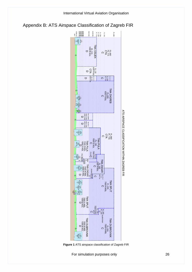
Airspace classification
• Zagreb FIR encompasses airspace classes:
C, D, G See Appendix B
NOTE: IFR flights are not permitted in G airspace in Zagreb FIR
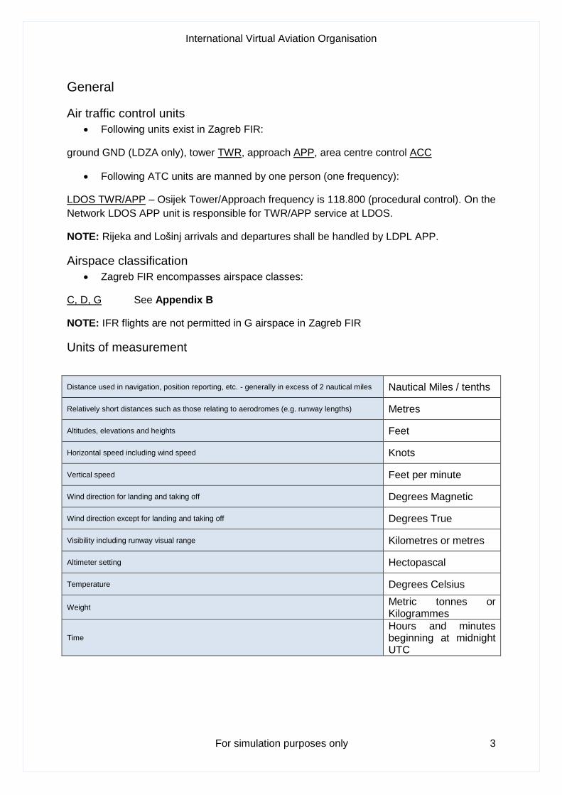
Units of measurement
Distance used in navigation, position reporting, etc. - generally in excess of 2 nautical miles Nautical Miles / tenths
Relatively short distances such as those relating to aerodromes (e.g. runway lengths) Metres
Altitudes, elevations and heights Feet
Horizontal speed including wind speed Knots
Vertical speed Feet per minute
Wind direction for landing and taking off Degrees Magnetic
Wind direction except for landing and taking off Degrees True
Visibility including runway visual range Kilometres or metres
Altimeter setting Hectopascal
Temperature Degrees Celsius
Weight Metric tonnes or Kilogrammes
Time Hours and minutes beginning at midnight UTC
International Virtual Aviation Organisation
For simulation purposes only 4
Radar services
• The radar separation minima shall be as follows:
Zagreb Area Control - 5 NM
Dubrovnik Approach Control - 5 NM
Split Approach Control - 5 NM
Zadar Approach Control - 5 NM
Zagreb Approach Control - 5 NM
Pula Approach Control - 5 NM
• In the event of radar failure or loss of radar identification, instructions will be issued to
restore non-radar standard separation. If the aircraft’s radio is completely
unserviceable, the pilot should carry out the procedures for radio failure in
accordance with provisions from Regulations on Rules of the Air and ATS. If radar
identification has already been established, the radar controller will vector other
identified aircraft clear of its track until such time as the aircraft leaves radar cover.
• In emergency situations, the pilot shall maintain the last assigned code, unless otherwise instructed. In addition to, the pilot may select Mode A, Code 7700, whenever they believe that would be the best course of action, in view of the nature of the situation. A pilot experiencing the radio communication failure shall operate the SSR transponder to Mode A, Code 7600 and take actions prescribed for such a situation.
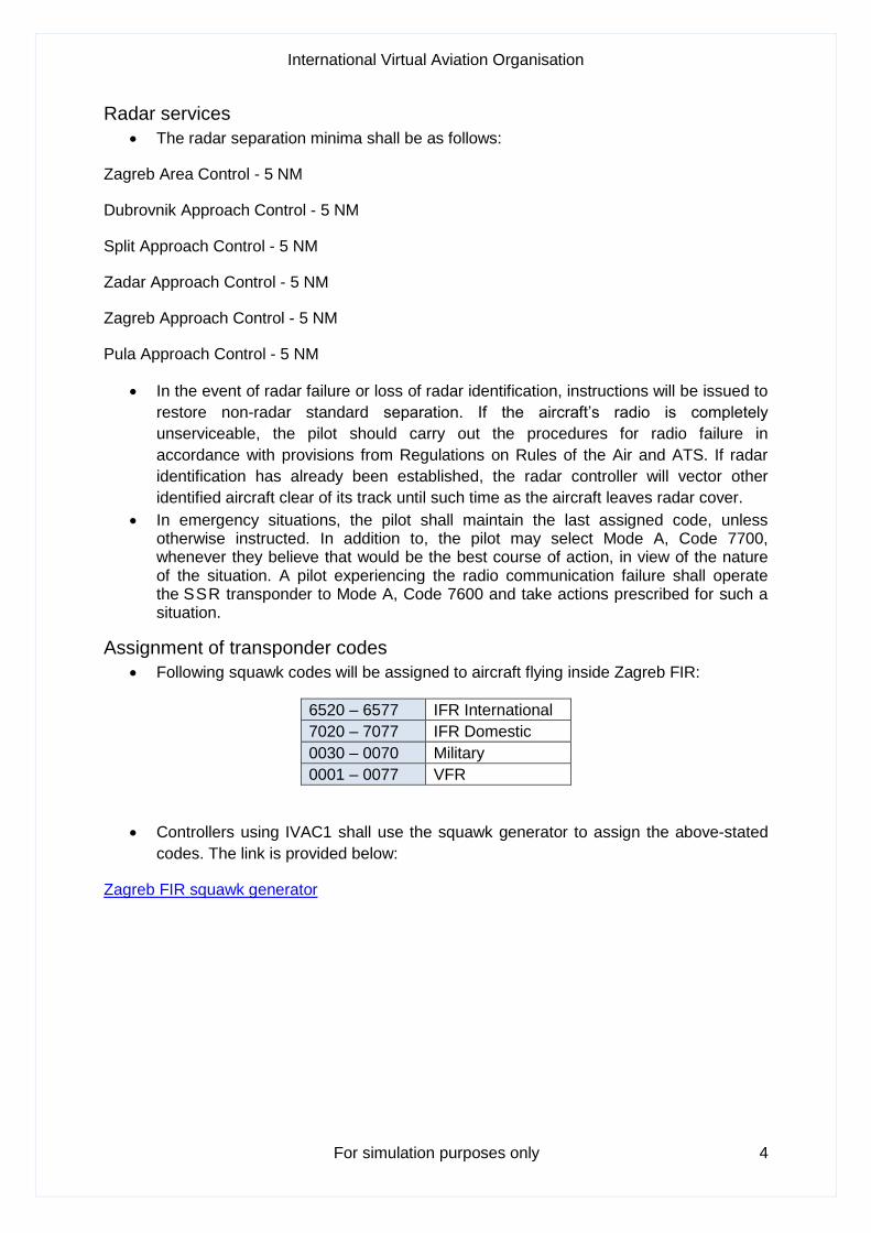
Assignment of transponder codes
• Following squawk codes will be assigned to aircraft flying inside Zagreb FIR:
6520 – 6577 IFR International
7020 – 7077 IFR Domestic
0030 – 0070 Military
0001 – 0077 VFR
• Controllers using IVAC1 shall use the squawk generator to assign the above-stated
codes. The link is provided below:
Zagreb FIR squawk generator
International Virtual Aviation Organisation
For simulation purposes only 5
Altimeter setting procedures
• Transition altitude is specified as 10,000 ft MSL.
• Vertical positioning of aircraft when at or below the transition altitude is expressed in
terms of altitude, whereas such positioning at or above the transition level is
expressed in terms of flight levels. While passing through the transition layer, vertical
positioning is expressed in terms of altitude when descending and in terms of flight
levels when ascending.
• Flight level zero is located at the atmospheric pressure level of 1013.25 hPa (29.92
in).
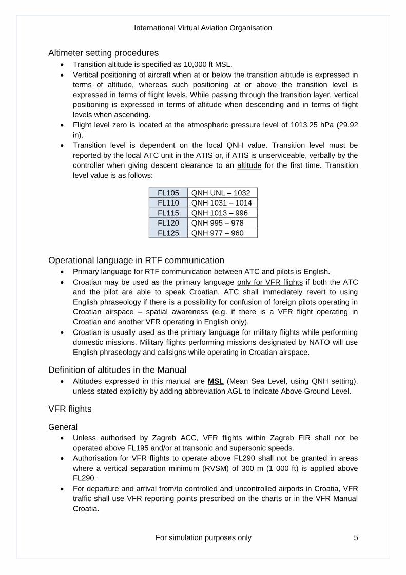
• Transition level is dependent on the local QNH value. Transition level must be
reported by the local ATC unit in the ATIS or, if ATIS is unserviceable, verbally by the
controller when giving descent clearance to an altitude for the first time. Transition
level value is as follows:
FL105 QNH UNL – 1032
FL110 QNH 1031 – 1014
FL115 QNH 1013 – 996
FL120 QNH 995 – 978
FL125 QNH 977 – 960
Operational language in RTF communication
• Primary language for RTF communication between ATC and pilots is English.
• Croatian may be used as the primary language only for VFR flights if both the ATC
and the pilot are able to speak Croatian. ATC shall immediately revert to using
English phraseology if there is a possibility for confusion of foreign pilots operating in
Croatian airspace – spatial awareness (e.g. if there is a VFR flight operating in
Croatian and another VFR operating in English only).
• Croatian is usually used as the primary language for military flights while performing
domestic missions. Military flights performing missions designated by NATO will use
English phraseology and callsigns while operating in Croatian airspace.
Definition of altitudes in the Manual
• Altitudes expressed in this manual are MSL (Mean Sea Level, using QNH setting),
unless stated explicitly by adding abbreviation AGL to indicate Above Ground Level.
VFR flights
General
• Unless authorised by Zagreb ACC, VFR flights within Zagreb FIR shall not be
operated above FL195 and/or at transonic and supersonic speeds.
• Authorisation for VFR flights to operate above FL290 shall not be granted in areas
where a vertical separation minimum (RVSM) of 300 m (1 000 ft) is applied above
FL290.
• For departure and arrival from/to controlled and uncontrolled airports in Croatia, VFR
traffic shall use VFR reporting points prescribed on the charts or in the VFR Manual
Croatia.
International Virtual Aviation Organisation
For simulation purposes only 6
Traffic circuit training flights
• Standard altitude for all traffic circuit training flights in Croatia, if not otherwise
specified in the AIP, is 1500 ft (approximately 1000 ft AGL).
• Mandatory reporting positions are downwind and final.
• All non-standard traffic circuit phraseology regarding positions in the circuit must
include word RIGHT to indicate a right-hand side circuit (non-standard circuit).
VFR routes
• Aircraft operating as VFR shall prefer using Recommended VFR Routes in Croatia
when flying outside of CTRs (domestic or international VFR). These routes are
named: ADRIA, VELEB and PANON with a number afterwards to identify the specific
route (e.g. ADRIA1). Chart with Recommended VFR Routes can be found in the VFR
Manual Croatia (section VFR supplements).
• Beside the routes, as mentioned above, aircraft shall use VFR reporting points to
enter/exit aerodrome control zone (CTR). Aircraft shall contact responsible ATC unit
at least 5 minutes before entering the airspace (via the reporting points) – consult
VFR Manual Croatia (Part 3 Aerodromes, AD 2 Aerodromes)
International Virtual Aviation Organisation
For simulation purposes only 7
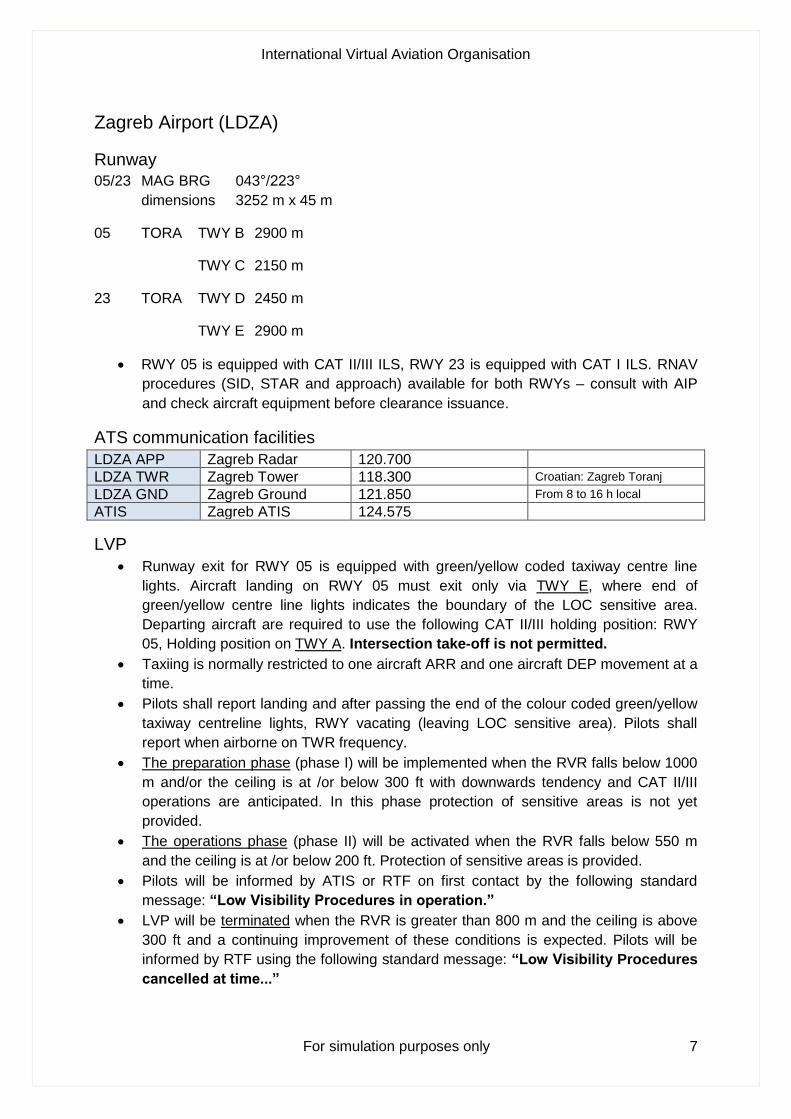
Zagreb Airport (LDZA)
Runway
05/23 MAG BRG 043°/223°
dimensions 3252 m x 45 m
05 TORA TWY B 2900 m
TWY C 2150 m
23 TORA TWY D 2450 m
TWY E 2900 m
• RWY 05 is equipped with CAT II/III ILS, RWY 23 is equipped with CAT I ILS. RNAV
procedures (SID, STAR and approach) available for both RWYs – consult with AIP
and check aircraft equipment before clearance issuance.
ATS communication facilities
LDZA APP Zagreb Radar 120.700
LDZA TWR Zagreb Tower 118.300 Croatian: Zagreb Toranj
LDZA GND Zagreb Ground 121.850 From 8 to 16 h local
ATIS Zagreb ATIS 124.575
LVP
• Runway exit for RWY 05 is equipped with green/yellow coded taxiway centre line
lights. Aircraft landing on RWY 05 must exit only via TWY E, where end of
green/yellow centre line lights indicates the boundary of the LOC sensitive area.
Departing aircraft are required to use the following CAT II/III holding position: RWY
05, Holding position on TWY A. Intersection take-off is not permitted.
• Taxiing is normally restricted to one aircraft ARR and one aircraft DEP movement at a
time.
• Pilots shall report landing and after passing the end of the colour coded green/yellow
taxiway centreline lights, RWY vacating (leaving LOC sensitive area). Pilots shall
report when airborne on TWR frequency.
• The preparation phase (phase I) will be implemented when the RVR falls below 1000
m and/or the ceiling is at /or below 300 ft with downwards tendency and CAT II/III
operations are anticipated. In this phase protection of sensitive areas is not yet
provided.
• The operations phase (phase II) will be activated when the RVR falls below 550 m
and the ceiling is at /or below 200 ft. Protection of sensitive areas is provided.
• Pilots will be informed by ATIS or RTF on first contact by the following standard
message: “Low Visibility Procedures in operation.”
• LVP will be terminated when the RVR is greater than 800 m and the ceiling is above
300 ft and a continuing improvement of these conditions is expected. Pilots will be
informed by RTF using the following standard message: “Low Visibility Procedures
cancelled at time...”
International Virtual Aviation Organisation
For simulation purposes only 8
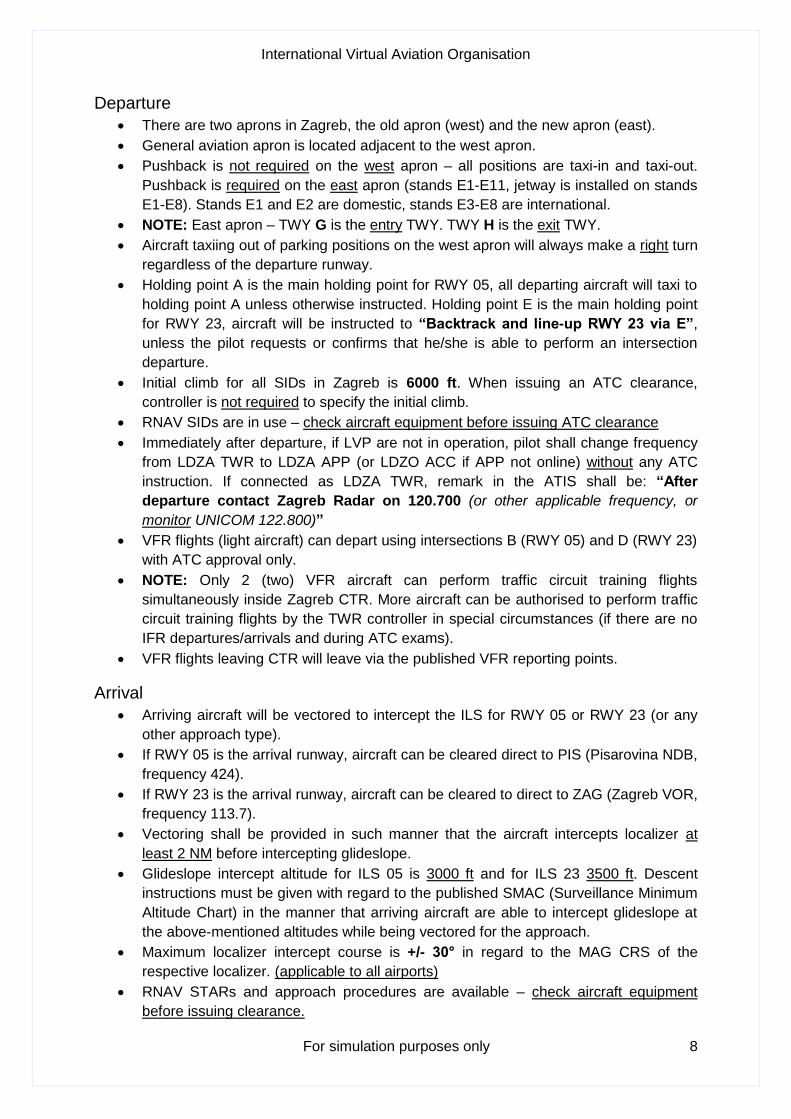
Departure
• There are two aprons in Zagreb, the old apron (west) and the new apron (east).
• General aviation apron is located adjacent to the west apron.
• Pushback is not required on the west apron – all positions are taxi-in and taxi-out.
Pushback is required on the east apron (stands E1-E11, jetway is installed on stands
E1-E8). Stands E1 and E2 are domestic, stands E3-E8 are international.
• NOTE: East apron – TWY G is the entry TWY. TWY H is the exit TWY.
• Aircraft taxiing out of parking positions on the west apron will always make a right turn
regardless of the departure runway.
• Holding point A is the main holding point for RWY 05, all departing aircraft will taxi to
holding point A unless otherwise instructed. Holding point E is the main holding point
for RWY 23, aircraft will be instructed to “Backtrack and line-up RWY 23 via E”,
unless the pilot requests or confirms that he/she is able to perform an intersection
departure.
• Initial climb for all SIDs in Zagreb is 6000 ft. When issuing an ATC clearance,
controller is not required to specify the initial climb.
• RNAV SIDs are in use – check aircraft equipment before issuing ATC clearance
• Immediately after departure, if LVP are not in operation, pilot shall change frequency
from LDZA TWR to LDZA APP (or LDZO ACC if APP not online) without any ATC
instruction. If connected as LDZA TWR, remark in the ATIS shall be: “After
departure contact Zagreb Radar on 120.700 (or other applicable frequency, or
monitor UNICOM 122.800)”
• VFR flights (light aircraft) can depart using intersections B (RWY 05) and D (RWY 23)
with ATC approval only.
• NOTE: Only 2 (two) VFR aircraft can perform traffic circuit training flights
simultaneously inside Zagreb CTR. More aircraft can be authorised to perform traffic
circuit training flights by the TWR controller in special circumstances (if there are no
IFR departures/arrivals and during ATC exams).
• VFR flights leaving CTR will leave via the published VFR reporting points.
Arrival
• Arriving aircraft will be vectored to intercept the ILS for RWY 05 or RWY 23 (or any
other approach type).
• If RWY 05 is the arrival runway, aircraft can be cleared direct to PIS (Pisarovina NDB,
frequency 424).
• If RWY 23 is the arrival runway, aircraft can be cleared to direct to ZAG (Zagreb VOR,
frequency 113.7).
• Vectoring shall be provided in such manner that the aircraft intercepts localizer at
least 2 NM before intercepting glideslope.
• Glideslope intercept altitude for ILS 05 is 3000 ft and for ILS 23 3500 ft. Descent
instructions must be given with regard to the published SMAC (Surveillance Minimum
Altitude Chart) in the manner that arriving aircraft are able to intercept glideslope at
the above-mentioned altitudes while being vectored for the approach.
• Maximum localizer intercept course is +/- 30° in regard to the MAG CRS of the
respective localizer. (applicable to all airports)
• RNAV STARs and approach procedures are available – check aircraft equipment
before issuing clearance.

International Virtual Aviation Organisation
For simulation purposes only 9
• If RNAV approach is to be expected, the following message shall be included in ATIS
remark: “Expect ILS or RNAV approach” by TWR and APP unit.
• RNAV STARs are published with vertical profiles – aircraft need to be cleared by ATC
to follow this vertical profile by phrase: “Cleared XXXXX1Z arrival, descend via
STAR” – vertical profile following in Zagreb FIR is usually not given, descent
clearances are therefore given by the respective ATC unit.
• If using RNAV approaches, aircraft must reach the IAF (Initial Approach Fix) for the
respective approach at the prescribed altitude.
• Aircraft may be cleared direct to RNAV approach IAF – when issuing descent
instructions, the TAA (Terminal Arrival Altitude) shall be respected.
• Aircraft shall be cleared for RNAV approach before reaching the IAF.
• Aircraft will vacate RWY 05 via TWYs C, D or E, if LVP are not in operation. Aircraft
will vacate RWY 23 via TWYs C or B. If LVP in operation, aircraft will vacate via E.
• After vacating the runway, ATC will not provide parking position number for the west
apron parking stands. Instruction for the east apron stands shall be: “C/S, taxi via
__ and __ to stand E_”. In the real-life aircraft would be guided by the follow-me car
to their parking position. Pilots shall report on stand only when on the east apron.
International Virtual Aviation Organisation
For simulation purposes only 10
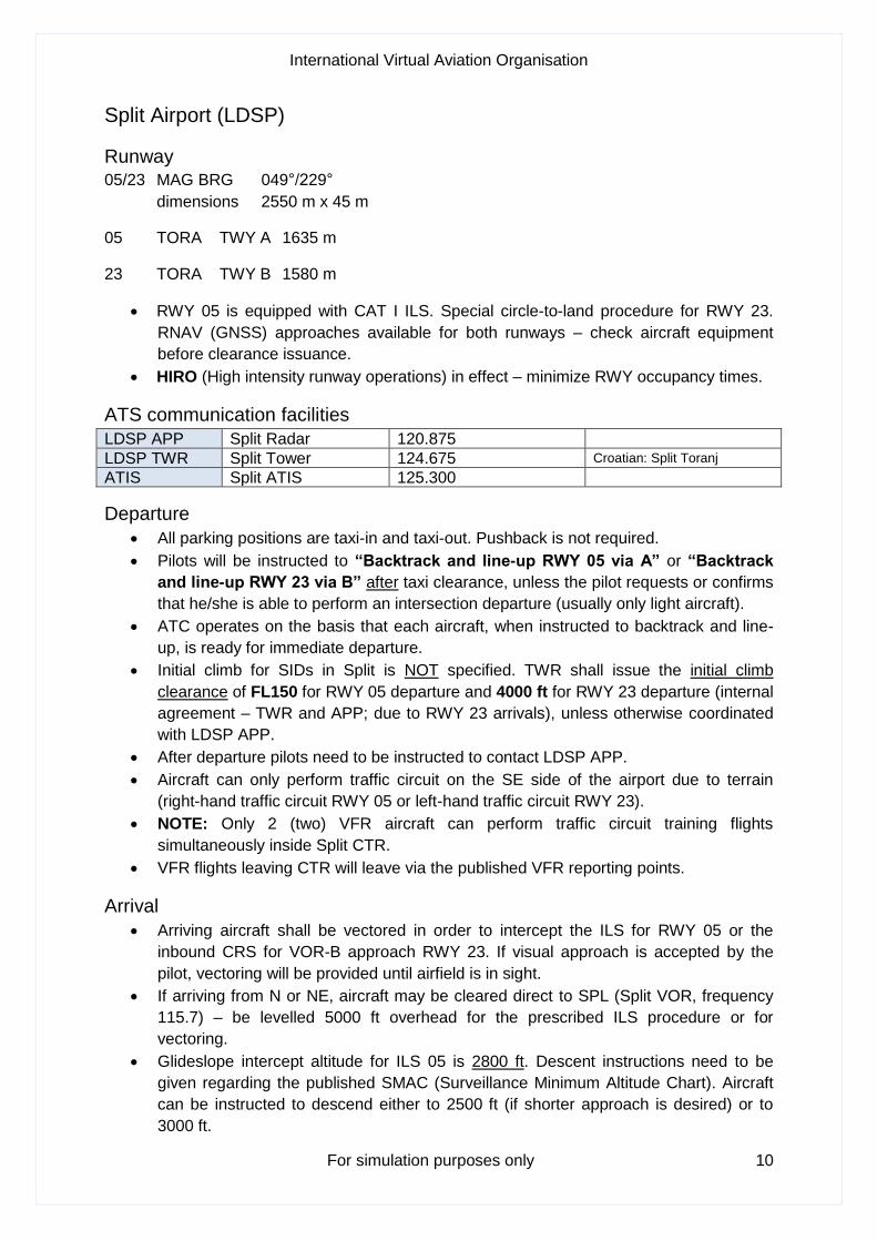
Split Airport (LDSP)
Runway
05/23 MAG BRG 049°/229°
dimensions 2550 m x 45 m
05 TORA TWY A 1635 m
23 TORA TWY B 1580 m
• RWY 05 is equipped with CAT I ILS. Special circle-to-land procedure for RWY 23.
RNAV (GNSS) approaches available for both runways – check aircraft equipment
before clearance issuance.
• HIRO (High intensity runway operations) in effect – minimize RWY occupancy times.
ATS communication facilities
LDSP APP Split Radar 120.875
LDSP TWR Split Tower 124.675 Croatian: Split Toranj
ATIS Split ATIS 125.300
Departure
• All parking positions are taxi-in and taxi-out. Pushback is not required.
• Pilots will be instructed to “Backtrack and line-up RWY 05 via A” or “Backtrack
and line-up RWY 23 via B” after taxi clearance, unless the pilot requests or confirms
that he/she is able to perform an intersection departure (usually only light aircraft).
• ATC operates on the basis that each aircraft, when instructed to backtrack and line-
up, is ready for immediate departure.
• Initial climb for SIDs in Split is NOT specified. TWR shall issue the initial climb
clearance of FL150 for RWY 05 departure and 4000 ft for RWY 23 departure (internal
agreement – TWR and APP; due to RWY 23 arrivals), unless otherwise coordinated
with LDSP APP.
• After departure pilots need to be instructed to contact LDSP APP.
• Aircraft can only perform traffic circuit on the SE side of the airport due to terrain
(right-hand traffic circuit RWY 05 or left-hand traffic circuit RWY 23).
• NOTE: Only 2 (two) VFR aircraft can perform traffic circuit training flights
simultaneously inside Split CTR.
• VFR flights leaving CTR will leave via the published VFR reporting points.
Arrival
• Arriving aircraft shall be vectored in order to intercept the ILS for RWY 05 or the
inbound CRS for VOR-B approach RWY 23. If visual approach is accepted by the
pilot, vectoring will be provided until airfield is in sight.
• If arriving from N or NE, aircraft may be cleared direct to SPL (Split VOR, frequency
115.7) – be levelled 5000 ft overhead for the prescribed ILS procedure or for
vectoring.
• Glideslope intercept altitude for ILS 05 is 2800 ft. Descent instructions need to be
given regarding the published SMAC (Surveillance Minimum Altitude Chart). Aircraft
can be instructed to descend either to 2500 ft (if shorter approach is desired) or to
3000 ft.
International Virtual Aviation Organisation
For simulation purposes only 11
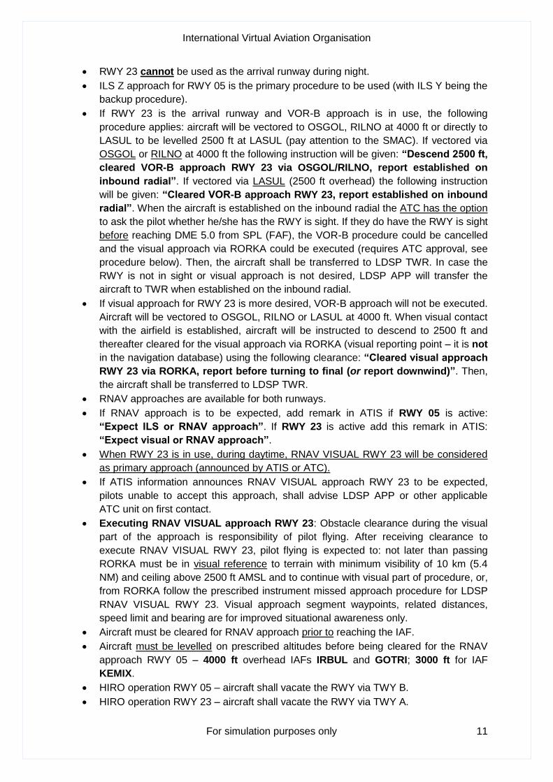
• RWY 23 cannot be used as the arrival runway during night.
• ILS Z approach for RWY 05 is the primary procedure to be used (with ILS Y being the
backup procedure).
• If RWY 23 is the arrival runway and VOR-B approach is in use, the following
procedure applies: aircraft will be vectored to OSGOL, RILNO at 4000 ft or directly to
LASUL to be levelled 2500 ft at LASUL (pay attention to the SMAC). If vectored via
OSGOL or RILNO at 4000 ft the following instruction will be given: “Descend 2500 ft,
cleared VOR-B approach RWY 23 via OSGOL/RILNO, report established on
inbound radial”. If vectored via LASUL (2500 ft overhead) the following instruction
will be given: “Cleared VOR-B approach RWY 23, report established on inbound
radial”. When the aircraft is established on the inbound radial the ATC has the option
to ask the pilot whether he/she has the RWY is sight. If they do have the RWY is sight
before reaching DME 5.0 from SPL (FAF), the VOR-B procedure could be cancelled
and the visual approach via RORKA could be executed (requires ATC approval, see
procedure below). Then, the aircraft shall be transferred to LDSP TWR. In case the
RWY is not in sight or visual approach is not desired, LDSP APP will transfer the
aircraft to TWR when established on the inbound radial.
• If visual approach for RWY 23 is more desired, VOR-B approach will not be executed.
Aircraft will be vectored to OSGOL, RILNO or LASUL at 4000 ft. When visual contact
with the airfield is established, aircraft will be instructed to descend to 2500 ft and
thereafter cleared for the visual approach via RORKA (visual reporting point – it is not
in the navigation database) using the following clearance: “Cleared visual approach
RWY 23 via RORKA, report before turning to final (or report downwind)”. Then,
the aircraft shall be transferred to LDSP TWR.
• RNAV approaches are available for both runways.
• If RNAV approach is to be expected, add remark in ATIS if RWY 05 is active:
“Expect ILS or RNAV approach”. If RWY 23 is active add this remark in ATIS:
“Expect visual or RNAV approach”.
• When RWY 23 is in use, during daytime, RNAV VISUAL RWY 23 will be considered
as primary approach (announced by ATIS or ATC).
• If ATIS information announces RNAV VISUAL approach RWY 23 to be expected,
pilots unable to accept this approach, shall advise LDSP APP or other applicable
ATC unit on first contact.
• Executing RNAV VISUAL approach RWY 23: Obstacle clearance during the visual
part of the approach is responsibility of pilot flying. After receiving clearance to
execute RNAV VISUAL RWY 23, pilot flying is expected to: not later than passing
RORKA must be in visual reference to terrain with minimum visibility of 10 km (5.4
NM) and ceiling above 2500 ft AMSL and to continue with visual part of procedure, or,
from RORKA follow the prescribed instrument missed approach procedure for LDSP
RNAV VISUAL RWY 23. Visual approach segment waypoints, related distances,
speed limit and bearing are for improved situational awareness only.
• Aircraft must be cleared for RNAV approach prior to reaching the IAF.
• Aircraft must be levelled on prescribed altitudes before being cleared for the RNAV
approach RWY 05 – 4000 ft overhead IAFs IRBUL and GOTRI; 3000 ft for IAF
KEMIX.
• HIRO operation RWY 05 – aircraft shall vacate the RWY via TWY B.
• HIRO operation RWY 23 – aircraft shall vacate the RWY via TWY A.
International Virtual Aviation Organisation
For simulation purposes only 12
• If the aircraft has passed the designated TWY, the pilot should make a 180° turn on
the RWY (before reaching the turning bay) and vacate the RWY without delay.
• If a pilot of an arriving aircraft needs full RWY length, he/she must notify ATC as soon
as possible.
• After vacating the runway, ATC will not provide parking position number. In the real-
life aircraft would be guided by the follow-me car to their parking position. Do not
request pilots to “report on blocks”.
Water Airports Resnik (LDSR) and Port Split (LDST) • Airports are exclusively VFR.
• Located inside Split CTR. Two-way radio communication with LDSP TWR (departures
and arrivals) and LDSP APP (arrivals outside of LDSP CTR) is required.
• Water airports do not have ATS provider on the ground (water). Port of Split Authority
is responsible for the movement of the aircraft when on ground (water). Departure
clearance is required for the airspace above the aerodrome.
• For further information consult VFR Manual Croatia.
• Landing clearance shall be issued in the following format: “Cleared to land direction
__ (05, 23, etc.), wind __/__, report landed”.
International Virtual Aviation Organisation
For simulation purposes only 13
Dubrovnik Airport (LDDU)
Runway
11/29 MAG BRG 114°/294°
dimensions 3299 m x 45 m
11 TORA TWY B 2270 m
TWY C 1800 m
TWY D 1350 m
29 TORA TWY E 2400 m
TWY D 1780 m
TWY C 1340 m
• RWY 11 is equipped with CAT I ILS. VOR-A and circle-to-land procedure RWY 29.
RNAV approaches available for both RWYs (GNSS for RWY 11, RNP for RWY 29) –
check aircraft equipment before clearance issuance.
• Preferential RWY 11
ATS communication facilities
LDDU APP Dubrovnik Radar 123.600
LDDU TWR Dubrovnik Tower 129.500 Croatian: Dubrovnik Toranj
Departure
• All parking positions (except 1A, 16A and 19A) are taxi-in and push-out – which
means that pushback is required. Parking positions 1-10 and 15-20 are taxi-out if one
of the adjacent stand is not occupied. Standard pushback instruction shall be: “Start-
up and pushback approved RWY __, QNH __”.
• If RWY 11 is departure runway, the main holding point is A. Holding points B and C
can be used for VFR flights (light aircraft) only if the pilot accepts intersection
departure.
• If RWY 29 is departure runway, aircraft will be instructed to “Taxi via I to holding
point F (E) RWY 29, (backtrack and line-up RWY 29)”, unless the pilot requests or
confirms that he/she is able to perform an intersection departure. Holding point D can
be used for VFR flights only.
• Initial climb for SIDs in Dubrovnik is NOT specified. TWR shall issue the initial climb
clearance of FL150 (internal agreement between TWR and APP) unless otherwise
coordinated with LDDU APP.
• Departure information shall be given, when requested by pilots, instead of the ATIS
(for all controlled airports in Croatia). Departure information format is as follows:
“Departure RWY __, wind __/__, QNH __, temp __, dew point __, (optionally:
visibility or RVR __, time __)”.
• After departure pilots need to be instructed to contact LDDU APP.
• Aircraft can only perform traffic circuit on the S side of the airport due to terrain (right-
hand traffic circuit RWY 11 or left-hand traffic circuit RWY 29).
International Virtual Aviation Organisation
For simulation purposes only 14
• NOTE: Only 2 (two) VFR aircraft can perform traffic circuit training flights
simultaneously inside Dubrovnik CTR.
• VFR flights leaving CTR will leave via the published VFR reporting points.
• TWY F is not yet implemented on any of LDDU sceneries, use TWY E instead.
Arrival
• RWY 11 is preferential in LDDU. Most common approach in use is ILS RWY 11.
• In case RNAV approach is being used (RWY 11 or RWY 29) aircraft is to be
instructed to the IAF (PILAP for RWY 11, OLEGU for RWY 29). Descent instructions
need to follow published SMAC to allow the aircraft to level off 5000 ft overhead
PILAP or 4000 ft overhead OLEGU. Aircraft must be cleared for the approach before
reaching the IAF.
• Aircraft can be vectored to intercept the localizer for RWY 11. In this case, aircraft can
be instructed to descend to 5000 ft and cleared for the ILS when at least DME 15.0
from DBK VOR (115.4).
• Aircraft can be cleared direct to KLP (Koločep NDB, frequency 318) to be levelled
4000 ft overhead in order to be given a final vector to intercept the ILS.
• Aircraft can be cleared for NERRA8A arrival and thereafter cleared for straight-in ILS
approach (pay attention to minimum procedure altitudes and the SMAC).
• Glideslope intercept altitude for ILS 11 is 4000 ft. Descent instructions need to be
given regarding the published SMAC. Exception for ILS interception is 5000 ft when
at least DME 15.0 from DBK VOR.
• In case RWY 29 is active for arrival, ATC has multiple choices: RNAV (RNP), VOR-A
approach, vectoring for visual approach RWY 29 or circling with prescribed tracks
RWY 29. Priority should be given to the RNAV approach.
• Circling with prescribed tracks RWY 29 cannot be used during night.
• Before executing circling approach RWY 29 aircraft must be cleared for instrument
approach for RWY 11 (VOR, locator or LOC (GS out) approach) – refer to the
procedure chart. Following phraseology applies (in this example LOC (GS out)
approach is used): “Cleared localizer glideslope out approach RWY 11, report
RWY in sight”. The pilot then descends to circling MDA (2170 ft for C and D
category). When the RWY is in sight ATC instruction is: “Cleared circling approach
RWY 29, contact TWR on __” (if TWR is not online instruction for the pilot could be
to report downwind RWY 29 instead of contact TWR).
• Aircraft will vacate RWY 11 via TWYs C, D, E or F. Aircraft will vacate RWY 29 via
TWYs D, C or B.
• After vacating the runway, ATC will not provide parking position number. In the real-
life aircraft would be guided by the follow-me car to their parking position. Do not
request pilots to “report on blocks”.
• TWY F has not yet been implemented on sceneries. Use TWY E instead.
International Virtual Aviation Organisation
For simulation purposes only 15
Osijek Airport (LDOS)
Runway
11/29 MAG BRG 106°/286°
dimensions 2500 m x 45 m
11 TORA TWY A 1800 m
TWY B 1500 m
29 TORA TWY B 1000 m
TWY A 700 m
• RWY 29 and 11 are equipped with CAT I ILS. RNAV (GNSS) approach available for
RWY 11 – check aircraft equipment before clearance issuance.
ATS communication facilities
LDOS APP Osijek Approach 118.800 Croatian: Osijek Prilazna Kon.
LDOS TWR Osijek Tower 118.800 Croatian: Osijek Toranj
• On the Network LDOS APP is the only position available. LDOS TWR is not used.
Departure
• All parking positions are taxi-in and taxi-out. Pushback is not required.
• Aircraft will be instructed to backtrack and line-up RWY via A (RWY 11) or via B
(RWY 29) unless the pilot requests or confirms that he/she is able to perform an
intersection departure.
• Procedural control is used in Osijek. This means that a controller does not have a
radar screen. You cannot radar identify the aircraft nor provide vectors.
• Initial climb for SIDs in Osijek is NOT specified. APP (TWR) shall issue the initial
climb clearance of FL110 (Osijek TMA upper limit), unless otherwise coordinated with
LDZO ACC.
• RNAV SIDs are available for both RWYs – check aircraft equipment
• After departure pilots will be advised to report when passing 9000 ft. After the pilot
reports passing 9000 ft, a controller will transfer the aircraft to other respective
frequency.
• VFR flights leaving CTR will leave via the published VFR reporting points.
Arrival
• ILS Z and LOC Z RWY 29 are temporarily suspended. ILS X RWY 29 is operational
only for A and B category aircraft. ILS Y is operational. – refer to the chart
• Arriving aircraft shall be cleared onto the STAR (RNAV STARs available) with the
instruction “Descend via STAR” (both RWYs). If visual approach is desired, pilot
shall be instructed to “Report RWY in sight”. When the RWY is in sight ATC will
issue clearances accordingly (visual approach clearance, then landing clearance).
• If RWY 11 is the arrival runway, ILS, RNAV, locator RWY 11 approach via CE or
visual approaches are available. Remember, the aircraft is not under radar
control. – refer to the chart
• After vacating, ATC will not provide parking position number.
International Virtual Aviation Organisation
For simulation purposes only 16
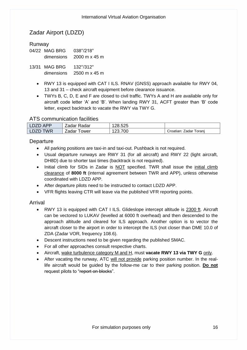
Zadar Airport (LDZD)
Runway
04/22 MAG BRG 038°/218°
dimensions 2000 m x 45 m
13/31 MAG BRG 132°/312°
dimensions 2500 m x 45 m
• RWY 13 is equipped with CAT I ILS. RNAV (GNSS) approach available for RWY 04,
13 and 31 – check aircraft equipment before clearance issuance.
• TWYs B, C, D, E and F are closed to civil traffic. TWYs A and H are available only for
aircraft code letter ‘A’ and ‘B’. When landing RWY 31, ACFT greater than ‘B’ code
letter, expect backtrack to vacate the RWY via TWY G.
ATS communication facilities
LDZD APP Zadar Radar 128.525
LDZD TWR Zadar Tower 123.700 Croatian: Zadar Toranj
Departure
• All parking positions are taxi-in and taxi-out. Pushback is not required.
• Usual departure runways are RWY 31 (for all aircraft) and RWY 22 (light aircraft,
DH8D) due to shorter taxi times (backtrack is not required).
• Initial climb for SIDs in Zadar is NOT specified. TWR shall issue the initial climb
clearance of 8000 ft (internal agreement between TWR and APP), unless otherwise
coordinated with LDZD APP.
• After departure pilots need to be instructed to contact LDZD APP.
• VFR flights leaving CTR will leave via the published VFR reporting points.
Arrival
• RWY 13 is equipped with CAT I ILS. Glideslope intercept altitude is 2300 ft. Aircraft
can be vectored to LUKAV (levelled at 6000 ft overhead) and then descended to the
approach altitude and cleared for ILS approach. Another option is to vector the
aircraft closer to the airport in order to intercept the ILS (not closer than DME 10.0 of
ZDA (Zadar VOR, frequency 108.6).
• Descent instructions need to be given regarding the published SMAC.
• For all other approaches consult respective charts.
• Aircraft, wake turbulence category M and H, must vacate RWY 13 via TWY G only.
• After vacating the runway, ATC will not provide parking position number. In the real-
life aircraft would be guided by the follow-me car to their parking position. Do not
request pilots to “report on blocks”.
International Virtual Aviation Organisation
For simulation purposes only 17
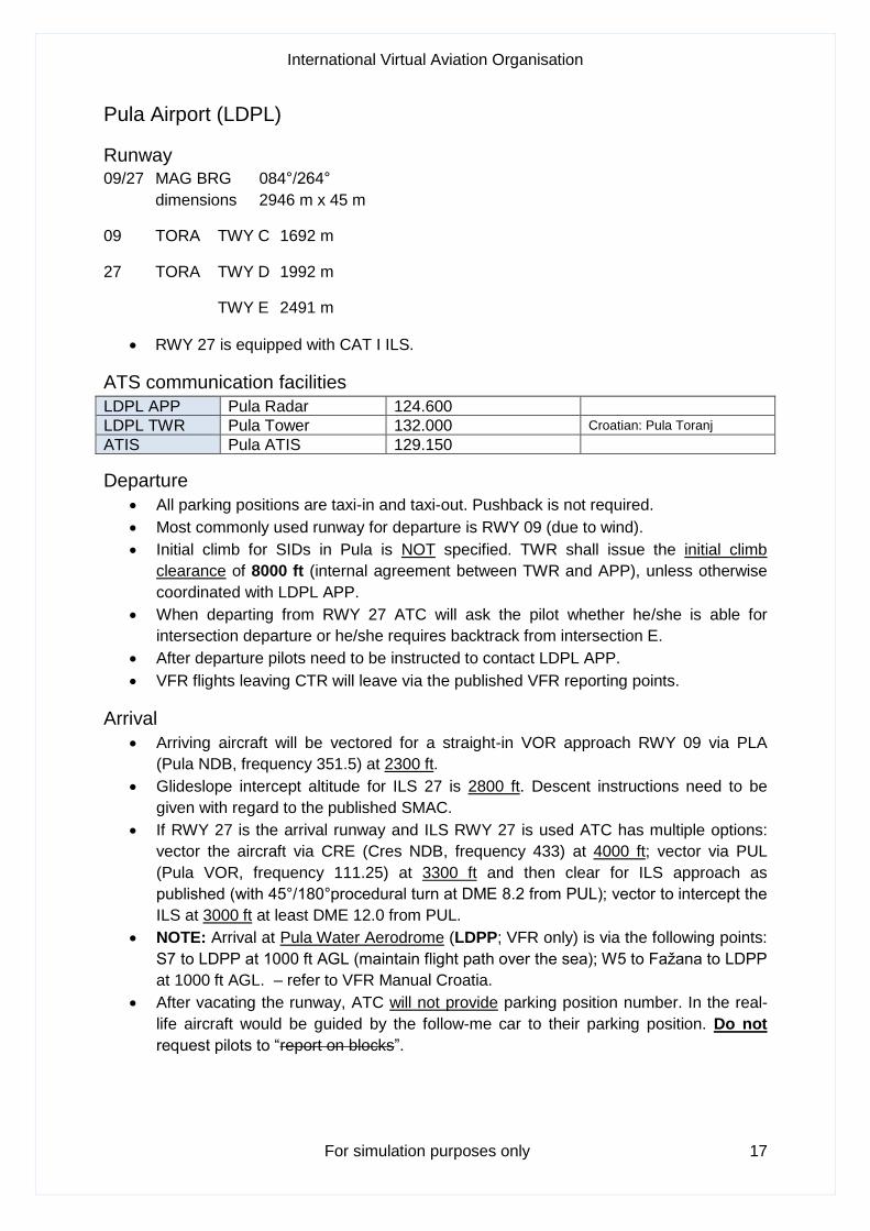
Pula Airport (LDPL)
Runway
09/27 MAG BRG 084°/264°
dimensions 2946 m x 45 m
09 TORA TWY C 1692 m
27 TORA TWY D 1992 m
TWY E 2491 m
• RWY 27 is equipped with CAT I ILS.
ATS communication facilities
LDPL APP Pula Radar 124.600
LDPL TWR Pula Tower 132.000 Croatian: Pula Toranj
ATIS Pula ATIS 129.150
Departure
• All parking positions are taxi-in and taxi-out. Pushback is not required.
• Most commonly used runway for departure is RWY 09 (due to wind).
• Initial climb for SIDs in Pula is NOT specified. TWR shall issue the initial climb
clearance of 8000 ft (internal agreement between TWR and APP), unless otherwise
coordinated with LDPL APP.
• When departing from RWY 27 ATC will ask the pilot whether he/she is able for
intersection departure or he/she requires backtrack from intersection E.
• After departure pilots need to be instructed to contact LDPL APP.
• VFR flights leaving CTR will leave via the published VFR reporting points.
Arrival
• Arriving aircraft will be vectored for a straight-in VOR approach RWY 09 via PLA
(Pula NDB, frequency 351.5) at 2300 ft.
• Glideslope intercept altitude for ILS 27 is 2800 ft. Descent instructions need to be
given with regard to the published SMAC.
• If RWY 27 is the arrival runway and ILS RWY 27 is used ATC has multiple options:
vector the aircraft via CRE (Cres NDB, frequency 433) at 4000 ft; vector via PUL
(Pula VOR, frequency 111.25) at 3300 ft and then clear for ILS approach as
published (with 45°/180°procedural turn at DME 8.2 from PUL); vector to intercept the
ILS at 3000 ft at least DME 12.0 from PUL.
• NOTE: Arrival at Pula Water Aerodrome (LDPP; VFR only) is via the following points:
S7 to LDPP at 1000 ft AGL (maintain flight path over the sea); W5 to Fažana to LDPP
at 1000 ft AGL. – refer to VFR Manual Croatia.
• After vacating the runway, ATC will not provide parking position number. In the real-
life aircraft would be guided by the follow-me car to their parking position. Do not
request pilots to “report on blocks”.
International Virtual Aviation Organisation
For simulation purposes only 18
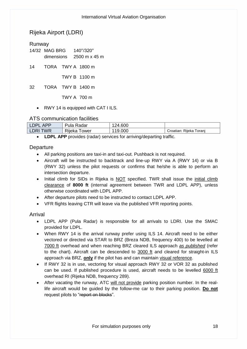
Rijeka Airport (LDRI)
Runway
14/32 MAG BRG 140°/320°
dimensions 2500 m x 45 m
14 TORA TWY A 1800 m
TWY B 1100 m
32 TORA TWY B 1400 m
TWY A 700 m
• RWY 14 is equipped with CAT I ILS.
ATS communication facilities
LDPL APP Pula Radar 124.600
LDRI TWR Rijeka Tower 119.000 Croatian: Rijeka Toranj
• LDPL APP provides (radar) services for arriving/departing traffic.
Departure
• All parking positions are taxi-in and taxi-out. Pushback is not required.
• Aircraft will be instructed to backtrack and line-up RWY via A (RWY 14) or via B
(RWY 32) unless the pilot requests or confirms that he/she is able to perform an
intersection departure.
• Initial climb for SIDs in Rijeka is NOT specified. TWR shall issue the initial climb
clearance of 8000 ft (internal agreement between TWR and LDPL APP), unless
otherwise coordinated with LDPL APP.
• After departure pilots need to be instructed to contact LDPL APP.
• VFR flights leaving CTR will leave via the published VFR reporting points.
Arrival
• LDPL APP (Pula Radar) is responsible for all arrivals to LDRI. Use the SMAC
provided for LDPL.
• When RWY 14 is the arrival runway prefer using ILS 14. Aircraft need to be either
vectored or directed via STAR to BRZ (Breza NDB, frequency 400) to be levelled at
7000 ft overhead and when reaching BRZ cleared ILS approach as published (refer
to the chart). Aircraft can be descended to 3000 ft and cleared for straight-in ILS
approach via BRZ, only if the pilot has and can maintain visual reference.
• If RWY 32 is in use, vectoring for visual approach RWY 32 or VOR 32 as published
can be used. If published procedure is used, aircraft needs to be levelled 6000 ft
overhead RI (Rijeka NDB, frequency 289).
• After vacating the runway, ATC will not provide parking position number. In the real-
life aircraft would be guided by the follow-me car to their parking position. Do not
request pilots to “report on blocks”.

International Virtual Aviation Organisation
For simulation purposes only 19
Brač Airport (LDSB)
Runway
04/22 MAG BRG 031°/211°
dimensions 1760 m x 30 m
04 TORA TWY A 550 m
22 TORA TWY A 1210 m
ATS communication facilities
LDSP APP Split Radar 120.875
LDSB TWR Brač Tower 118.025 Croatian: Brač Toranj
• Split Radar (LDSP APP) provides radar services for all arriving/departing traffic.
Departure
• All parking positions are taxi-in and taxi-out. Pushback is not required.
• Aircraft will be instructed to backtrack and line-up RWY via A.
• Initial climb for SIDs in Brač is NOT specified. TWR shall issue the initial climb
clearance of 4000 ft (Brač CTR upper limit), unless otherwise coordinated with LDSP
APP.
• After departure pilots need to be instructed to contact LDSP APP.
• VFR flights leaving CTR will leave via the published VFR reporting points.
Arrival
• LDSP APP will provide vectors for visual approach. RWY 22 is usually used for
arrivals. RWY 04 is preferred for departures (depending on the wind).
• Aircraft shall be vectored so as to avoid overflying LDSP (Split Airport). For flights
arriving via SPL (Split VOR, frequency 115.7) provide vectors to the southeast before
reaching SPL. Plan for the aircraft to be around 8000 ft overhead/abeam Split city.
Refer to the SMAC for LDSP. After passing the mainland and when overhead Brač
Channel descend the aircraft to 4000 ft, provide information on airport's position and,
when in sight, clear the pilot for visual approach. Then transfer the aircraft to TWR.
• After vacating the runway, ATC will not provide parking position number. In the real-
life aircraft would be guided by the follow-me car to their parking position. Do not
request pilots to “report on blocks”.
International Virtual Aviation Organisation
For simulation purposes only 20
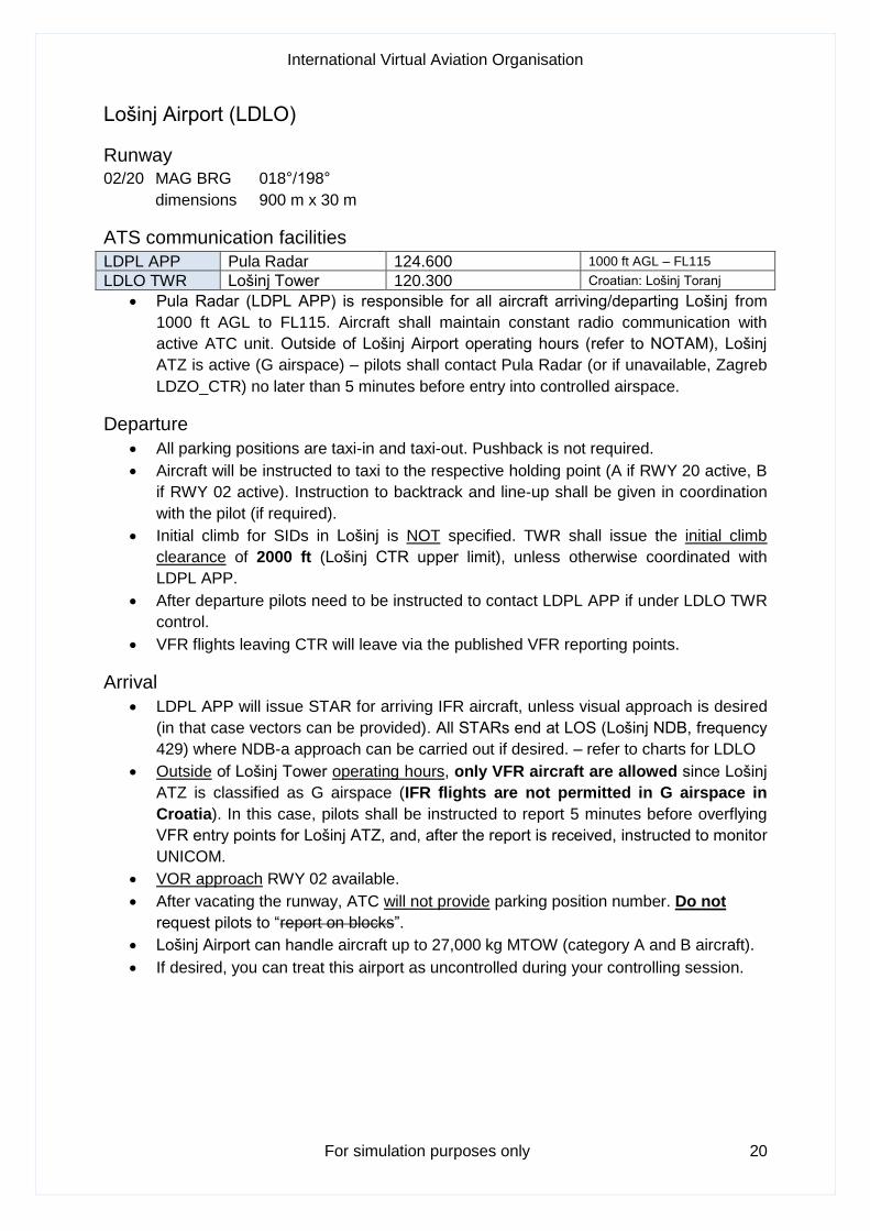
Lošinj Airport (LDLO)
Runway
02/20 MAG BRG 018°/198°
dimensions 900 m x 30 m
ATS communication facilities
LDPL APP Pula Radar 124.600 1000 ft AGL – FL115
LDLO TWR Lošinj Tower 120.300 Croatian: Lošinj Toranj
• Pula Radar (LDPL APP) is responsible for all aircraft arriving/departing Lošinj from
1000 ft AGL to FL115. Aircraft shall maintain constant radio communication with
active ATC unit. Outside of Lošinj Airport operating hours (refer to NOTAM), Lošinj
ATZ is active (G airspace) – pilots shall contact Pula Radar (or if unavailable, Zagreb
LDZO_CTR) no later than 5 minutes before entry into controlled airspace.
Departure
• All parking positions are taxi-in and taxi-out. Pushback is not required.
• Aircraft will be instructed to taxi to the respective holding point (A if RWY 20 active, B
if RWY 02 active). Instruction to backtrack and line-up shall be given in coordination
with the pilot (if required).
• Initial climb for SIDs in Lošinj is NOT specified. TWR shall issue the initial climb
clearance of 2000 ft (Lošinj CTR upper limit), unless otherwise coordinated with
LDPL APP.
• After departure pilots need to be instructed to contact LDPL APP if under LDLO TWR
control.
• VFR flights leaving CTR will leave via the published VFR reporting points.
Arrival
• LDPL APP will issue STAR for arriving IFR aircraft, unless visual approach is desired
(in that case vectors can be provided). All STARs end at LOS (Lošinj NDB, frequency
429) where NDB-a approach can be carried out if desired. – refer to charts for LDLO
• Outside of Lošinj Tower operating hours, only VFR aircraft are allowed since Lošinj
ATZ is classified as G airspace (IFR flights are not permitted in G airspace in
Croatia). In this case, pilots shall be instructed to report 5 minutes before overflying
VFR entry points for Lošinj ATZ, and, after the report is received, instructed to monitor
UNICOM.
• VOR approach RWY 02 available.
• After vacating the runway, ATC will not provide parking position number. Do not
request pilots to “report on blocks”.
• Lošinj Airport can handle aircraft up to 27,000 kg MTOW (category A and B aircraft).
• If desired, you can treat this airport as uncontrolled during your controlling session.
International Virtual Aviation Organisation
For simulation purposes only 21
Zagreb ACC
General
• Zagreb ACC (callsign: Zagreb Radar, LDZO_CTR – do not confuse _CTR (ATC
position abbreviation for ACC on IVAO) with CTR (control zone, an airspace type)) is
responsible for the airspace of the Republic of Croatia that is not included in TMAs or
CTRs.
• On the Network, LDZO_CTR is responsible for the entire Zagreb FIR and other
delegated airspace if there are no ATC units connected in Croatia (APPs and TWRs).
• Zagreb FIR/UIR extends from ground to unlimited. Controlled airspace extends from
1000 ft AGL to FL660 (excluding CTRs) – this airspace is called Control Area (CTA).
• Classification of CTA is as follows: C – between FL115 and FL660; D – below FL115
to 1000 ft AGL. Airspace below 1000 ft AGL outside of CTRs is classified as G
(uncontrolled airspace).
Frequencies in Zagreb FIR (LDZO)
• Following frequencies are used in Zagreb FIR:
Login name Callsign Frequency Remarks
LDZO_CTR Zagreb Radar 135.800 All
LDZO_N_CTR Zagreb Radar 132.125 North sector
LDZO_WS_CTR Zagreb Radar 135.800 Adria sector
LDZO_FSS Zagreb Information 135.050 VFR only, procedural
LDZA_APP Zagreb Radar 120.700
LDZA_TWR Zagreb Tower 118.300
LDZA_GND Zagreb Ground 121.850 From 8 to 16 h local
LDSP_APP Split Radar 120.875
LDSP_TWR Split Tower 124.675
LDDU_APP Dubrovnik Radar 123.600
LDDU_TWR Dubrovnik Tower 129.500
LDOS_APP Osijek Approach 118.800 Procedural
LDZD_APP Zadar Radar 128.525
LDZD_TWR Zadar Tower 123.700
LDPL_APP Pula Radar 124.600 Respb arr/dep LDRI
LDPL_TWR Pula Tower 132.000
LDRI_TWR Rijeka Tower 119.000
LDSB_TWR Brač Tower 118.025
LDLO_TWR Lošinj Tower 120.300 upon NOTAM
UNICOM UNICOM 122.800
Emergency GUARD 121.500
Coordination with other ATS units
• For ATS units providing services within Zagreb FIR: Zagreb ACC can descend
arriving aircraft to upper TMA vertical limit + 500 ft, e.g. for LDZA FL210 (transfer to
APP usually done 2000 ft before reaching assigned level), unless otherwise
coordinated with respective APPs. Transfer must be done before the aircraft reaches
its final waypoint (most commonly STAR entry point).
International Virtual Aviation Organisation
For simulation purposes only 22
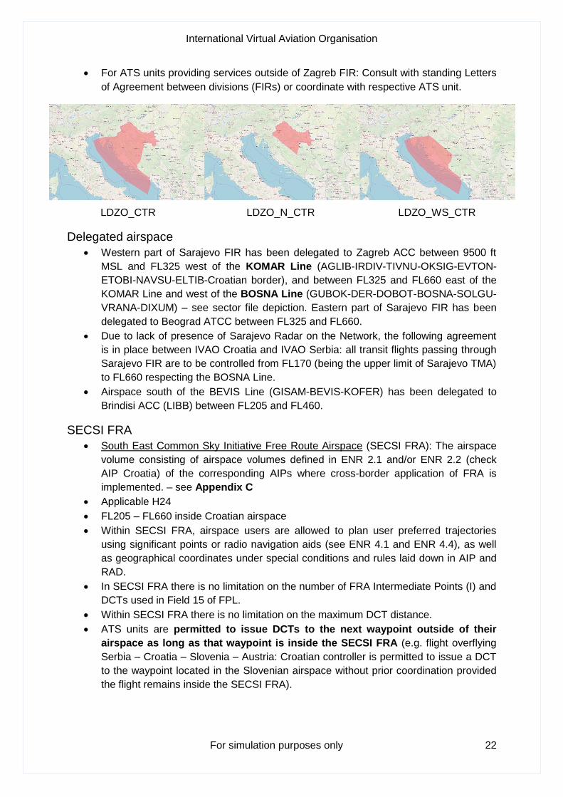
• For ATS units providing services outside of Zagreb FIR: Consult with standing Letters
of Agreement between divisions (FIRs) or coordinate with respective ATS unit.
LDZO_CTR LDZO_N_CTR LDZO_WS_CTR
Delegated airspace
• Western part of Sarajevo FIR has been delegated to Zagreb ACC between 9500 ft
MSL and FL325 west of the KOMAR Line (AGLIB-IRDIV-TIVNU-OKSIG-EVTON-
ETOBI-NAVSU-ELTIB-Croatian border), and between FL325 and FL660 east of the
KOMAR Line and west of the BOSNA Line (GUBOK-DER-DOBOT-BOSNA-SOLGU-
VRANA-DIXUM) – see sector file depiction. Eastern part of Sarajevo FIR has been
delegated to Beograd ATCC between FL325 and FL660.
• Due to lack of presence of Sarajevo Radar on the Network, the following agreement
is in place between IVAO Croatia and IVAO Serbia: all transit flights passing through
Sarajevo FIR are to be controlled from FL170 (being the upper limit of Sarajevo TMA)
to FL660 respecting the BOSNA Line.
• Airspace south of the BEVIS Line (GISAM-BEVIS-KOFER) has been delegated to
Brindisi ACC (LIBB) between FL205 and FL460.
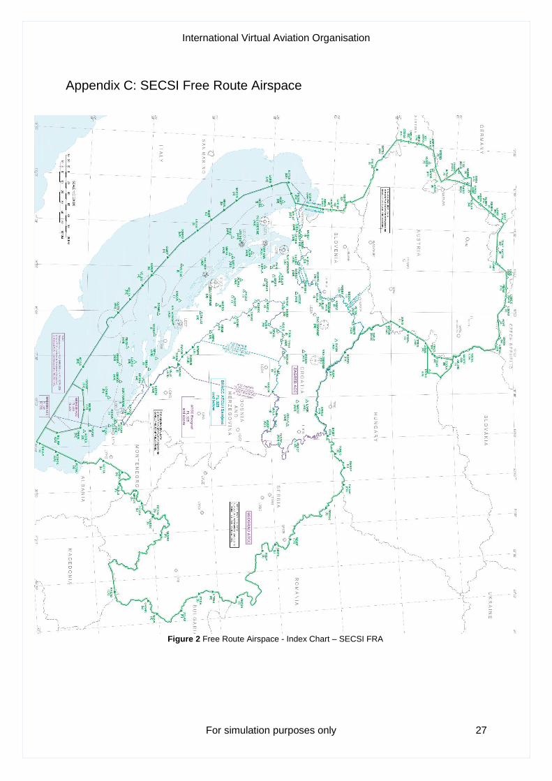
SECSI FRA
• South East Common Sky Initiative Free Route Airspace (SECSI FRA): The airspace
volume consisting of airspace volumes defined in ENR 2.1 and/or ENR 2.2 (check
AIP Croatia) of the corresponding AIPs where cross-border application of FRA is
implemented. – see Appendix C
• Applicable H24
• FL205 – FL660 inside Croatian airspace
• Within SECSI FRA, airspace users are allowed to plan user preferred trajectories
using significant points or radio navigation aids (see ENR 4.1 and ENR 4.4), as well
as geographical coordinates under special conditions and rules laid down in AIP and
RAD.
• In SECSI FRA there is no limitation on the number of FRA Intermediate Points (I) and
DCTs used in Field 15 of FPL.
• Within SECSI FRA there is no limitation on the maximum DCT distance.
• ATS units are permitted to issue DCTs to the next waypoint outside of their
airspace as long as that waypoint is inside the SECSI FRA (e.g. flight overflying
Serbia – Croatia – Slovenia – Austria: Croatian controller is permitted to issue a DCT
to the waypoint located in the Slovenian airspace without prior coordination provided
the flight remains inside the SECSI FRA).

International Virtual Aviation Organisation
For simulation purposes only 23
Appendix A: Acronyms and Abbreviations
ACC Area Centre Control Unit or Area Centre Controller (IVAO)
ADC Aerodrome Controller (IVAO)
AGL Above Ground Level
AIP Aeronautical Information Publication
APC Approach Controller (IVAO)
APP Approach or Approach Control Unit
ARR Arrival
AS Student Controller (IVAO)
ATC Air Traffic Control
ATIS Automatic Terminal Information Service
ATS Air Traffic Services
ATZ Aerodrome Traffic Zone
BRG Bearing
C/S Callsign
CAT Category
CRS Course
CTA Control Area
CTR Aerodrome Control Zone
DCT Direct to
DEP Departure
DME Distance Measuring Equipment
ENR Enroute
FAF Final Approach Fix
FIR Flight Information Region
FL Flight Level
FPL Filed Flight Plan
FRA Facility Rating Assignment
International Virtual Aviation Organisation
For simulation purposes only 24
FRA Free Route Airspace
FSS Flight Service Station
GND Ground or Ground Control Unit
GNSS Global Navigation Satellite System
GS Glideslope
HIRO High Intensity Runway Operations
HKZP Hrvatska kontrola zračne plovidbe
IAF Initial Approach Fix
IFR Instrument Flight Rules
ILS Instrument Landing System
IVAO International Virtual Aviation Organisation
LOC Localizer
LVP Low Visibility Procedures
MAG Magnetic
MSL Mean Sea Level
MTOW Maximum Take-off Weight
NATO North Atlantic Treaty Organisation
NDB Non-directional Beacon
NM Nautical Mile
QNH The altimeter sub-scale setting to obtain elevation when on the ground
RAD Route Availability Document
RNAV Area Navigation
RNP Required Navigation Performance
RTF Radiotelephony
RVR Runway Visual Range
RVSM Reduced Vertical Separation Minima
RWY Runway
SEC Senior Controller (IVAO)
SECSI South East Common Sky Initiative
International Virtual Aviation Organisation
For simulation purposes only 25
SID Standard Instrument Departure
SMAC Surveillance Minimum Altitude Chart
SSR Secondary Surveillance Radar
STAR Standard Terminal Arrival Route
TAA Terminal Arrival Altitude
TMA Terminal Control Area
TORA Take-off Run Available
TWR Aerodrome Control Tower Unit
TWY Taxiway
UIR Upper Flight Information Region
UNICOM Universal Communications Frequency (IVAO)
UTC Coordinated Universal Time
VFR Visual Flight Rules
VOR Very High Frequency Omnidirectional Range
International Virtual Aviation Organisation
For simulation purposes only 26
Appendix B: ATS Airspace Classification of Zagreb FIR
Figure 1 ATS airspace classification of Zagreb FIR
International Virtual Aviation Organisation
For simulation purposes only 27
Appendix C: SECSI Free Route Airspace
Figure 2 Free Route Airspace - Index Chart – SECSI FRA