Embed Size (px)
Citation preview

GI
CC
GR
GMHC
LB
R-TH
R-SFR-SF
PD
R-SF R-SF R-SFR-TH
R-SF
R-SF
GM
LB
HM
GM
HM
620
703
615
811806
711
810
612
803
706
601
730
712
820
800
726
800
700
727
826
814807
731
822827
801
823825
801804
614
734
821
707
811
1314
1314
1255
1221
1300
E BROWER ST
E CHESTNUT EXPY
N PRO
SPEC
T AVE
N NAT
IONAL
AVE
N ROG
ERS A
VE
´
LOCATION SKETCH
- Area of Proposal
Development Review Staff ReportDepartment of Planning & Development - 417-864-1031840 Boonville - Springfield, Missouri 65802
Z-34-2017 w/ Conditional Overlay District #139LOCATION: 1255 East Chestnut ExpresswayCURRENT ZONE: GR, General Retail District w/ Conditional Overlay District #10PROPOSED ZONE: GR, General Retail District w/ Conditional Overlay District #139
0 300 600150Feet
1 inch = 200 feetPlanning and Zoning Commission 1 of 12
Exhibit D

826
620
703
817
615
715
811
722
806
711
816810
612
803
706
601
730
712
820
721
800
726
800
700
727
826
814807
731
822827
801
823817
716
825
801
816
804
614
734
821
707
811
1314
1314
1255
1221
1300
1134
E BROWER ST
E CHESTNUT EXPY
N PRO
SPEC
T AVE
N NAT
IONAL
AVE
N ROG
ERS A
VE
´
LOCATION SKETCH
- Area of Proposal
Development Review Staff ReportDepartment of Planning & Development - 417-864-1031840 Boonville - Springfield, Missouri 65802
Z-34-2017 w/ Conditional Overlay District #139LOCATION: 1255 East Chestnut ExpresswayCURRENT ZONE: GR, General Retail District w/ Conditional Overlay District #10PROPOSED ZONE: GR, General Retail District w/ Conditional Overlay District #139
0 300 600150Feet
1 inch = 200 feetPlanning and Zoning Commission 2 of 12

DEVELOPMENT REVIEW STAFF REPORT ZONING CASE Z-34-2017 & CONDITIONAL OVERLAY DISTRICT NO. 139
PURPOSE: To rezone approximately 1.62 acres generally located at 1255 East
Chestnut Expressway from a GR, General Retail District with Conditional Overlay District #10 to a GR, General Retail District and establishing Conditional Overlay District No. 139
REPORT DATE: October 27, 2017 LOCATION: 1255 East Chestnut Expressway APPLICANT: Arvest Bank TRACT SIZE: Approximately 1.62 acres EXISTING USE: Undeveloped land PROPOSED USE: Uses permitted in GR, General Retail District unless restricted by
Conditional Overlay District No. 139 FINDINGS FOR STAFF RECOMMENDATION:
1. Approval of this application will maintain the GR, General Retail zoning but remove the Conditional Overlay District requirement of a .25 Floor Area Ratio (FAR). The FAR restricts the building total floor area to twenty-five (25) percent of the property. The applicant’s proposal is to remove this requirement from the existing Conditional Overlay District in order to facilitate development of the subject property. All other requirements of the COD are being retained.
2. In January 2014, Council approved General Ordinance No. 6094 which removed FAR requirements from the Zoning Ordinance in all zoning districts. The reason for the removal of FAR requirements was because other requirements such as bulk plane, structure height, bufferyards, open space and off-street parking requirements provide as effective building requirements and the FAR did not provide any additional protections to the public.
3. The removal of the FAR requirement for the subject property is not expected to negatively impact adjacent property. The subject property shall adhere to all other standards of the Zoning Ordinance, proposed Conditional Overlay District No. 136 and other applicable ordinances. The GR district requires a thirty (30) degree bulk plane measured from the adjacent R-SF zoned property to the North and East of the subject property.
Planning and Zoning Commission 3 of 12Planning and Zoning Commission 3 of 12

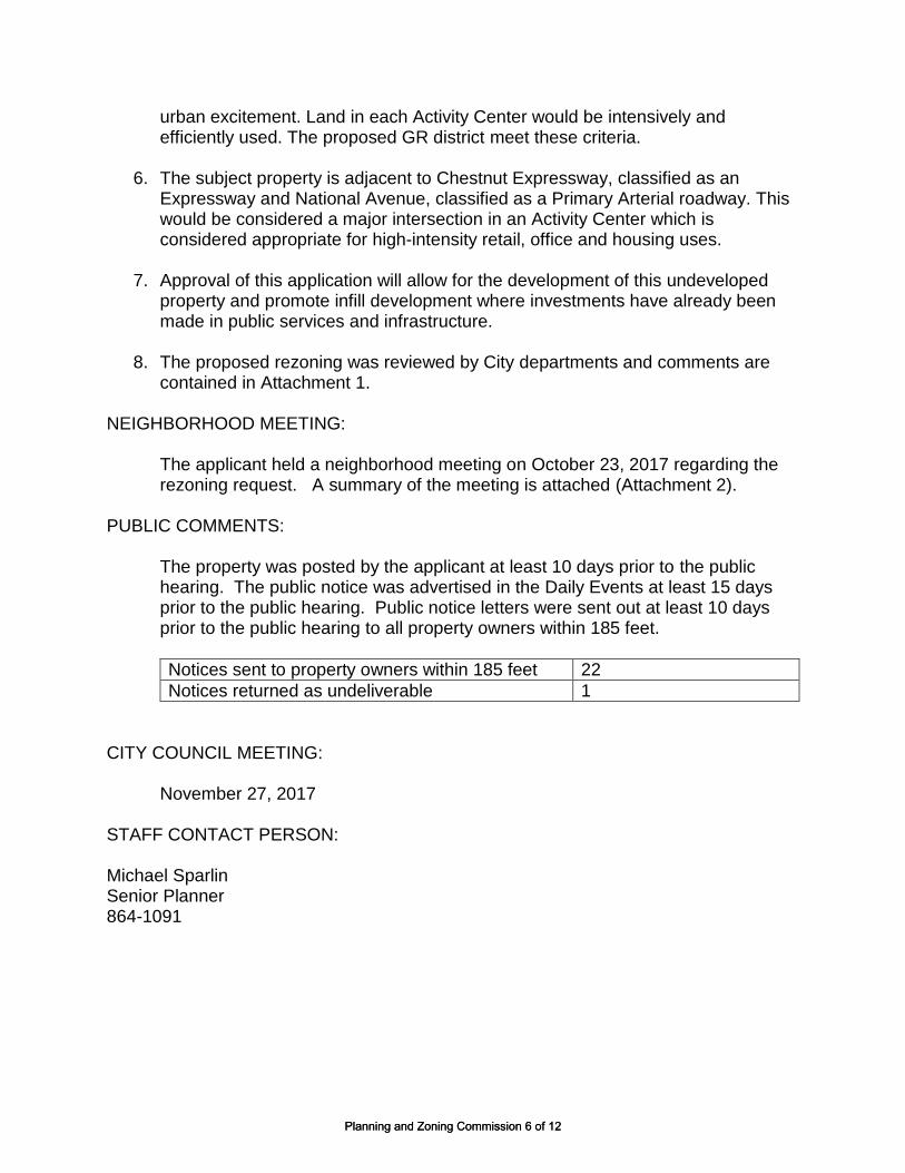
4. Approval of this application will allow for the development of this undeveloped property and promote infill development where investments have already been made in public services and infrastructure.
RECOMMENDATION: Staff recommends approval of this request. SURROUNDING LAND USES:
AREA ZONING LAND USE
North R-SF Single-family residential uses
East R-SF Single-family residential uses
South HC Commercial uses, undeveloped land
West GR w/ COD #10 Bank
HISTORY: In February 2008, Council approved General Ordinance 5739 rezoning property in this area from R-SF, R-TH and O-1 to the current zoning as GR, General Retail and establishing Conditional Overlay District No. 10. The subject property was a portion of the rezoning area. The property has remained undeveloped. COMPREHENSIVE PLAN: The Growth Management and Land Use Element of the Comprehensive Plan designates this property as appropriate for low-density housing. However, the Plan also states that “the land use plan map should not be taken too literally but should be used in conjunction with…policies of this plan and good judgment.” This land use category does not rule out the presence of what the Plan terms a “small neighborhood-oriented retail or service business carefully located and screened at certain intersections.” City Council rezoned the property in 2008 to General Retail with a Conditional Overlay District. The subject property is located in the Center City Activity Center. Activity Centers are intended to be locations of significant business and high-density housing development and that additional development be concentrated in and around the Activity Centers so as to optimize transportation investments, citizen convenience, investor confidence, a compact growth pattern, and a sense of urban excitement. Land in each Activity Center would be intensively and efficiently used.
Planning and Zoning Commission 4 of 12Planning and Zoning Commission 4 of 12

The Center City Plan Element states that Chestnut Expressway is a critically important entrance to Center City because it serves Center City districts to its north and south. It further states that intersection of National and Chestnut is considered a gateway and should be accentuated through special landscaping, lighting and signage, building orientation, location and massing. STAFF COMMENTS:
1. The applicant is proposing to rezone from GR, General Retail District with Conditional Overlay District No. 10 to GR, General Retail District and establishing Conditional Overlay District No. 139. The subject property was zoned to the current zoning in February 2008 and has remained undeveloped.
2. Approval of this application will maintain the GR, General Retail zoning but remove the Conditional Overlay District requirement of a .25 Floor Area Ratio (FAR). The FAR restricts the building total floor area to the size of the subject property. The current zoning restricts the building total floor area to twenty-five (25) percent of the property. The applicant’s proposal is to remove this requirement from the existing Conditional Overlay District in order to facilitate development of the subject property. All other requirements of the COD are being retained except those that have been already completed.
3. The COD No. 10’s Floor Area Ratio requirement was passed when the Zoning Ordinance had FAR requirements. In January 2014, Council approved General Ordinance No. 6094 which removed FAR requirements from the Zoning Ordinance in all zoning districts. The reason for the removal of FAR requirements was because other requirements such as bulk plane, structure height, bufferyards, open space and off-street parking requirements provide as effective building requirements and the FAR did not provide any additional protections to the public.
4. The removal of the FAR requirement for the subject property is not expected to negatively impact adjacent property. The subject property shall adhere to all other standards of the Zoning Ordinance, proposed Conditional Overlay District No. 136 and other applicable ordinances. The GR district requires a thirty (30) degree bulk plane measured from the adjacent R-SF zoned property to the North and East of the subject property. Removing the FAR requirement from this property makes it consistent with the lack of FAR requirements in the Zoning Ordinance.
5. The subject property is located in the Center City Activity Center. Activity Centers
are intended to be locations of significant business and high-density housing development and that additional development be concentrated in and around the Activity Centers so as to optimize transportation investments, citizen convenience, investor confidence, a compact growth pattern, and a sense of
Planning and Zoning Commission 5 of 12Planning and Zoning Commission 5 of 12
urban excitement. Land in each Activity Center would be intensively and efficiently used. The proposed GR district meet these criteria.
6. The subject property is adjacent to Chestnut Expressway, classified as an Expressway and National Avenue, classified as a Primary Arterial roadway. This would be considered a major intersection in an Activity Center which is considered appropriate for high-intensity retail, office and housing uses.
7. Approval of this application will allow for the development of this undeveloped
property and promote infill development where investments have already been made in public services and infrastructure.
8. The proposed rezoning was reviewed by City departments and comments are
contained in Attachment 1.
NEIGHBORHOOD MEETING:
The applicant held a neighborhood meeting on October 23, 2017 regarding the rezoning request. A summary of the meeting is attached (Attachment 2).
PUBLIC COMMENTS:
The property was posted by the applicant at least 10 days prior to the public hearing. The public notice was advertised in the Daily Events at least 15 days prior to the public hearing. Public notice letters were sent out at least 10 days prior to the public hearing to all property owners within 185 feet.
Notices sent to property owners within 185 feet 22
Notices returned as undeliverable 1
CITY COUNCIL MEETING: November 27, 2017
STAFF CONTACT PERSON: Michael Sparlin Senior Planner 864-1091
Planning and Zoning Commission 6 of 12Planning and Zoning Commission 6 of 12

ATTACHMENT 1
DEPARTMENT COMMENTS ZONING CASE Z-34-2017 & CONDITIONAL OVERLAY DISTRICT NO. 139
BUILDING DEVELOPMENT SERVICES COMMENTS: No objection to rezoning. PUBLIC WORKS TRAFFIC DIVISION COMMENTS: City's Transportation Plan classifies E. Chestnut Expressway as an Expressway, N. Prospect Avenue as a Local Street, and E. Brower Street as a Local Street. E. Chestnut Expressway is under MODOT jurisdiction. The standard right-of-way width for E. Chestnut Expressway is 65 feet from the centerline. The standard right-of-way width for N. Prospect Avenue is 30 feet from the centerline. The standard right-of-way width for E. Brower Street is 30 feet from the centerline. It appears additional right-of-way is not needed. A survey is recommended to determine the exact amount of existing right of way. N. Prospect Avenue, E. Brower Street, and the alleyway extending north from Brower Street are City maintained streets. The most recent traffic count on E. Chestnut Expressway east of N. National Avenue is 25,404 vehicles per day. The most recent traffic count on E. Brower Street east of N. National Avenue is 201 vehicles per day. There are no traffic counts for the portion of N. Prospect Avenue pertaining to the property in this zoning. There are two cross-access easement driveway points – one on E. Brower Street, one on N. Prospect Avenue – pertaining to the property in this zoning. There is sidewalk along the property frontage of E. Chestnut Expressway, N. Prospect Avenue, and E. Brower Street. The existing infrastructure meets current city standards. On-street parking is not allowed along E. Chestnut Expressway. There is a Greenway Trail just to the west of OTC’s campus. There are bus stops along E. Pythian Street to the north of the property pertaining to this zoning. The proposed development is in an area that provides for multiple direct connections and provides for good connectivity in the area. A traffic study was not required. The current permitted uses of the property in the GR w/ COD 10 zoning is similar to that of the proposed uses permitted in GR w/ COD 139 zoning. No additional trips generated are anticipated based on the change in zoning from GR w/ COD 10 to GR w/ COD 139.
Public Works Traffic Division Response
Street classification E. Chestnut Expressway – Expressway N. Prospect Avenue – Local E. Brower Street - Local
On-street parking along streets E. Chestnut Expressway – No N. Prospect Avenue – Yes E. Brower Street – Yes
Trips generated - Peak Hour 581 vehicles (GR-COD 10) 581 vehicles (GR-COD 139)
Planning and Zoning Commission 7 of 12Planning and Zoning Commission 7 of 12

Additional Trips generated with zoning change - Peak Hour
0 vehicles
Existing street right of way widths E. Chestnut Expressway: 73 ft from centerline N. Prospect Avenue: 40 ft from centerline E. Brower Street: 30 ft from centerline
Standard right of way widths E. Chestnut Expressway: 65 ft from centerline N. Prospect Avenue: 30 ft from centerline E. Brower Street: 30 ft from centerline
Traffic study submitted Not required
Proposed street improvements None required
STORMWATER COMMENTS: The property is in the Jordan Creek South Branch drainage basin. The property is not located in a FEMA designated floodplain. Staff is not aware of any flooding problems in the area. If the project increases the amount of impervious surfacing; detention and water quality is required according to Chapter 96. Buyout in lieu of on-site stormwater detention will be allowed. Since the project will be disturbing more than one (1) acre there will be a land disturbance permit required. This site has a previous buyout for detention not constructed in 2009. This site used pervious pavement to meet their water quality requirement. Please note that development of the property will be subject to the following conditions at the time of development:
1. Post development peak run-off rates shall not exceed pre-development peak run-off rates for the 1, 10 and 100 year rain events. Any increase in impervious surfacing will require the development to meet current detention and water quality requirements.
2. Please keep in mind that more detailed stormwater calculations must be submitted before any permits can be approved.
Public Works Stormwater Division Response
Drainage Basin Jordan Creek South Branch
Is property located in Floodplain? No
Is property located on a sinkhole? No
Is stormwater buyout an option? Yes
Is a land Disturbance Permit Required? Yes
CLEAN WATER SERVICES COMMENTS: No objections to rezoning. Public sewer is currently available. Any further review regarding capacity or point of connection will require additional plans.
Planning and Zoning Commission 8 of 12Planning and Zoning Commission 8 of 12

FIRE DEPARTMENT COMMENTS: No objection to rezoning CITY UTILITIES COMMENTS: No issues with the rezoning request. All utilities are available. MODOT COMMENTS: No objection to rezoning
Planning and Zoning Commission 9 of 12Planning and Zoning Commission 9 of 12

Attachment 2
Planning and Zoning Commission 10 of 12Planning and Zoning Commission 10 of 12

Planning and Zoning Commission 11 of 12Planning and Zoning Commission 11 of 12

ATTACHMENT 3 CONDITIONAL OVERLAY DISTRICT PROVISIONS
ZONING CASE Z-34-2017 & CONDITIONAL OVERLAY DISTRICT NO. 139
The requirements of Section 36-421 of the Springfield Zoning Ordinance shall be modified herein for development within this district to include the following.
A. Use Limitations:
1. Provide an internal pedestrian system connecting each building with one another and the public sidewalk system.
2. All multi-tenant buildings shall be similar in color and appearance to the Gateway Tower Feature located on the adjacent property to the west.
3. The detention structure shall have decorative walls. 4. Every effort shall be made to preserve as many existing mature trees as
possible.
B. Bulk and Intensity of Use:
1. Banks and Financial institutions with drive-thru facilities shall be limited to a maximum total of 6,500 square feet (Gross Floor Area)
2. Restaurants with drive-thru facilities shall be limited to a maximum total of 3,000 square feet (GFA).
3. Restaurants, taverns and cocktail lounges shall be limited to a maximum of 9,800 square feet (GFA). This restriction includes restaurants with drive-thru facilities as stated in item #2 above.
Planning and Zoning Commission 12 of 12Planning and Zoning Commission 12 of 12