Embed Size (px)
Citation preview

Ecoregions of the Yukon Territory, Part 2
Yukon Southern LakesBoreal Cordillera Ecozone
ECOREGION 177
DISTINGUISHING CHARACTERISTICS: Broad valleys and large lakes characterize this
ecoregion. Set within the rain shadow of the St. Elias Mountains, this ecoregion’s
climate is dry and cool. The Yukon Southern Lakes Ecoregion lies in the sporadic
discontinuous permafrost zone, where permafrost underlies less than one-
quarter of the landscape. Soils tend to be alkaline and wetlands (mainly
fens) are typically dominated by marl formation. The ecoregion supports
the highest mammalian diversity in the Yukon, with at least 50 of the
60 species known to occur in the Yukon at present.
Figure 177-1. The north end of Kusawa Lake is a broad U-shaped glacial valley. The surrounding upland is a dissected portion of the Teslin Plateau with a surface elevation 1,000 m higher than the valley floor.
J. M
eikl
e, Y
uko
n G
over
nmen
t
TOTAL AREA OF ECOREGION IN CANADA35,650 km2
TOTAL AREA OF ECOREGION IN THE YUKON29,892 km2
ECOREGION AREA AS A PROPORTION OF THE YUKON6%
APPROXIMATE LAND COVERboreal/subalpine coniferous forest, 65%alpine tundra, 25%rockland, 5%lakes and wetlands, 5%
ELEVATIONAL RANGE610–2,380 m asl mean elevation 1,055 m asl
CORRELATION TO OTHER ECOLOGICAL REGIONS: Equivalent to Lake Labarge Ecoregion (Oswald and Senyk, 1977) • Portion of Cordillera Boreal Region (CEC, 1997) • Southern portion of Interior Yukon Dry Forests (Ricketts et al., 1999)
6000
5500
5000
4500
4000
3500
3000
2500
2000
1500
1000
500
0
6000
5500
5000
4500
4000
3500
3000
2500
2000
1500
1000
500
0
Metres above sea level
207

Ecoregions of the Yukon Territory, Part 2
PHYSIOGRAPHYThe Yukon Southern Lakes Ecoregion, a large area of rounded summits and broad valleys, is part of the Yukon Plateau physiographic unit as defined by Bostock (1948) and Hughes (1987b). Most of this ecoregion is located in the Yukon, but a portion extends south into British Columbia to include the south end of Teslin Lake. The Teslin and Nisutlin plateaus, separated by the Teslin Fault, are the other physiographic subdivisions within this ecoregion (Bostock, 1948; Mathews, 1986). Some mountain groupings are the Sifton, Englishmans and Miners ranges. The topography consists of dissected plateaus, rolling hills and broad valleys occupied by lakes and rivers (Fig. 177-1).
Much of the terrain lies between 1,000 and 1,500 m asl. The highest peak is Mount Arkell at 2377 m asl. Other peaks over 2,000 m asl are Joe Mountain, Mount Lorne, Mount Byng, Pilot Mountain, and peaks in the Sifton and Englishman ranges. The major rivers and Lake Laberge all lie below 760 m asl.
The numerous large lakes and rivers give the ecoregion its name. Most of the lakes, such as Kusawa (Fig. 177-1), Teslin, Marsh and Laberge, and the larger rivers, the Yukon and Teslin, trend northwest–southeast or north–south. This pattern reflects the northwest-trending faults and folds of the bedrock.
BEDROCK GEOLOGYCoarse-grained, crystalline metamorphic and granitic rocks predominate in the eastern and western thirds of this ecoregion, while mafic volcanic rocks, limestone reefs and clastic sediments characterize the central third. The regional rock units are shown by Kindle (1953), Tempelman-Kluit (1974), Wheeler (1961) and Gordey and Stevens (1994a). Certain areas have been mapped in greater detail (Hart, 1997 and references therein) and a contemporary map interpretation of the terranes is given by Gordey and Makepeace (compilers, 2000).
Within the ecoregion are parts of four terranes — Yukon–Tanana, Stikinia, Cache Creek and Dorsey — each with different rock types and origins. The exposed rocks in each are summarized below, beginning in the west.
The area generally west of the Takhini River bridge on the Alaska Highway, belongs to the western part of Yukon–Tanana Terrane, intruded by various granitic components of the Coast Plutonic Complex. The former consists of strongly metamorphosed quartzofeldspathic schist (Erdmer, 1991) flanked by quartz–biotite schist, granitic gneiss, marble and amphibolite (Johnston and Timmerman, 1994). In the Coast Plutonic Complex, the Early Jurassic Little River and the Paleocene Annie Ned batholiths consist of resistant granite, with cliffs and large talus blocks resulting from planar vertical fractures or joints (Hart, 1997).
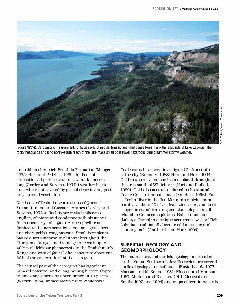
Northern Stikinia contains sedimentary and volcanic rocks. Augite basalt flows and tuffs of the Povoas Formation of the Lewes River Group predominate on the western part of the terrane. Upper Triassic to Middle Jurassic limestone, argillite, tuffaceous sandstone and conglomerate comprise the Whitehorse Trough (Hart, 1997), which is the largest element of northern Stikinia. Upper Triassic limestone forms sparsely vegetated, light-coloured cliffs, domes and pinnacles east of Lake Laberge (Fig. 177-2), with some notable fossil reef communities (Reid and Tempelman-Kluit, 1987). Areas of thick andesite and basalt flows in the north-central part of the ecoregion include the post-accretion (after Stikinia accreted to ancient North America) mid-Cretaceous Mount Byng, the Late Cretaceous Open Creek, and Carmacks Group (Hart, 1997). The Carmacks Group is notable for its alkaline shoshonitic chemistry (e.g. Johnston et al., 1996; Smuk et al., 1997). Numerous mid-Cretaceous granitic plutons that intrude Stikinia are named after nearby features, including Flat Creek, Haeckel Hill, Cap Mountain and Cap Creek, M’Clintock Lakes, Byng Creek and Mount M’Clintock (Fig. 41 in Hart, 1997). Vesicular basaltic lava erupted near Alligator Lake about 3 million years ago, leaving spatter cones and scoria-covered uplands southwest of Whitehorse. The columnar-jointed basalt lava flows between Cowley Creek, McCrae and the Whitehorse Rapids flowed from vents south of the Mount Sima ski area in several episodes between 15 and 8.5 Ma (Hart and Villeneuve, 1999).
The Cache Creek terrane, east of Carcross and between Marsh and Teslin lakes, contains altered basalt greenstone (Nakina Formation), crinoid- and fusilinid-bearing limestone (Horsefeed Formation)
Yukon Southern Lakes • ECOREGION 177
208
Ecoregions of the Yukon Territory, Part 2
and ribbon chert-rich Kedahda Formation (Monger, 1975; Hart and Pelletier, 1989a,b). Pods of serpentinized peridotite up to several kilometres long (Gordey and Stevens, 1994b) weather black and, where not covered by glacial deposits, support only stunted vegetation.
Northeast of Teslin Lake are strips of Quesnel, Yukon–Tanana and Cassiar terranes (Gordey and Stevens, 1994a). Rock types include siliceous argillite, siltstone and sandstone with abundant fresh augite crystals. Quartz–mica phyllite is flanked to the northeast by sandstone, grit, chert and chert pebble conglomerate. Small hornblende–biotite quartz monzonite plutons throughout the Thirtymile Range, and biotite granite with up to 40% pink feldspar phenocrysts in the Englishman’s Range and west of Quiet Lake, constitute about one-fifth of the eastern third of the ecoregion.
The central part of the ecoregion has significant mineral potential and a long mining history. Copper in limestone skarns has been mined in 13 places (Watson, 1984) immediately west of Whitehorse.
Coal seams have been investigated 24 km south of the city (Bremner, 1988; Hunt and Hart, 1994). Gold in quartz veins has been explored throughout the area south of Whitehorse (Hart and Radloff, 1990). Gold also occurs in altered rocks around Cache Creek ultramafic pods (e.g. Hart, 1996). East of Teslin River is the Red Mountain molybdenum porphyry, about 20 silver–lead–zinc veins, and both copper–iron and tin–tungsten skarn deposits, all related to Cretaceous plutons. Baked mudstone (Laberge Group) in a unique occurrence west of Fish Lake has traditionally been used for cutting and scraping tools (Gotthardt and Hare, 1994).
SURFICIAL GEOLOGY AND GEOMORPHOLOGYThe main sources of surficial geology information for the Yukon Southern Lakes Ecoregion are several surficial geology and soil maps (Rostad et al., 1977; Morison and McKenna, 1981; Klassen and Morison, 1987; Morison and Klassen, 1991; Mougeot and Smith, 1992 and 1994) and maps of terrain hazards
ECOREGION 177 • Yukon Southern Lakes
Figure 177-2. Carbonate cliffs (remnants of large reefs of middle Triassic age) and dense forest flank the east side of Lake Laberge. The rocky headlands and long north–south reach of the lake make small boat travel hazardous during summer stormy weather.
C.D
. Eck
ert,
Yuk
on
Gov
ernm
ent
209
Ecoregions of the Yukon Territory, Part 2
and geological information for all maps sheets (Yukon GEOPROCESS file, 2002).
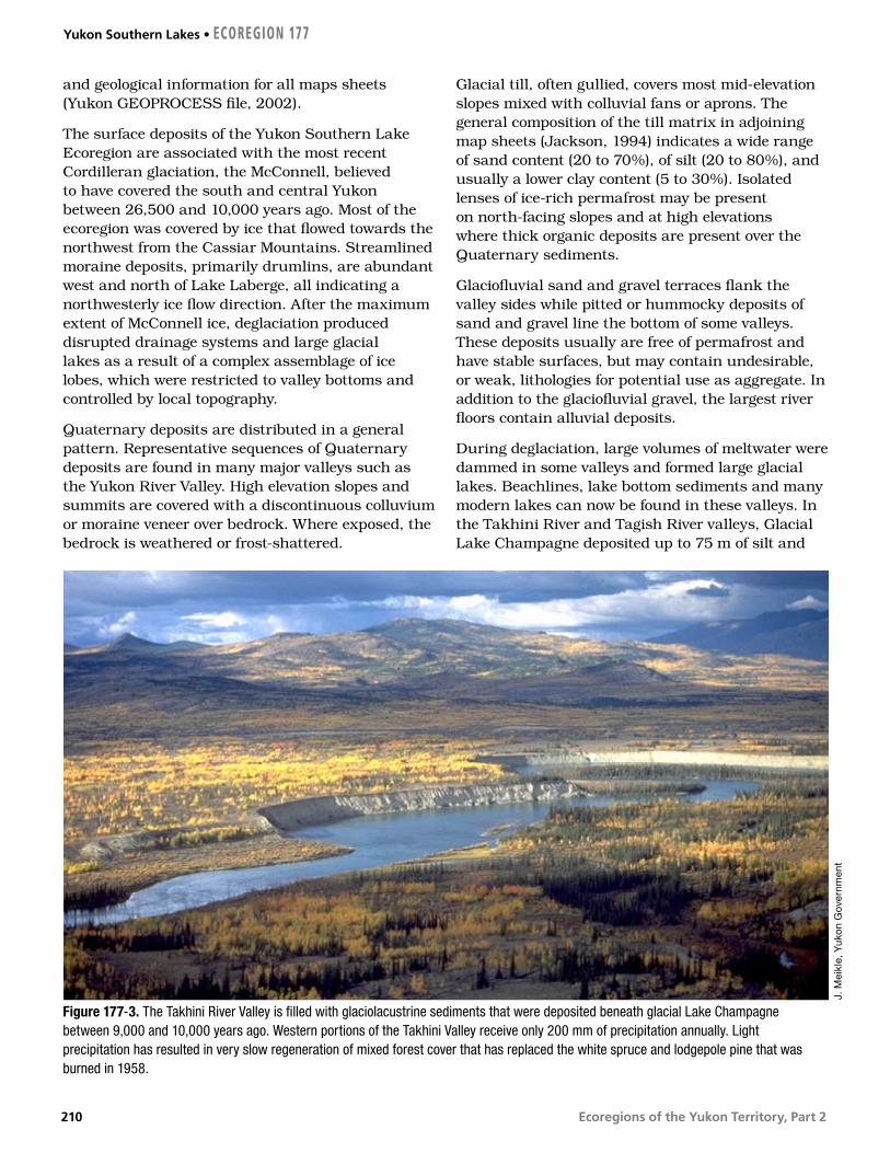
The surface deposits of the Yukon Southern Lake Ecoregion are associated with the most recent Cordilleran glaciation, the McConnell, believed to have covered the south and central Yukon between 26,500 and 10,000 years ago. Most of the ecoregion was covered by ice that flowed towards the northwest from the Cassiar Mountains. Streamlined moraine deposits, primarily drumlins, are abundant west and north of Lake Laberge, all indicating a northwesterly ice flow direction. After the maximum extent of McConnell ice, deglaciation produced disrupted drainage systems and large glacial lakes as a result of a complex assemblage of ice lobes, which were restricted to valley bottoms and controlled by local topography.
Quaternary deposits are distributed in a general pattern. Representative sequences of Quaternary deposits are found in many major valleys such as the Yukon River Valley. High elevation slopes and summits are covered with a discontinuous colluvium or moraine veneer over bedrock. Where exposed, the bedrock is weathered or frost-shattered.
Glacial till, often gullied, covers most mid-elevation slopes mixed with colluvial fans or aprons. The general composition of the till matrix in adjoining map sheets (Jackson, 1994) indicates a wide range of sand content (20 to 70%), of silt (20 to 80%), and usually a lower clay content (5 to 30%). Isolated lenses of ice-rich permafrost may be present on north-facing slopes and at high elevations where thick organic deposits are present over the Quaternary sediments.
Glaciofluvial sand and gravel terraces flank the valley sides while pitted or hummocky deposits of sand and gravel line the bottom of some valleys. These deposits usually are free of permafrost and have stable surfaces, but may contain undesirable, or weak, lithologies for potential use as aggregate. In addition to the glaciofluvial gravel, the largest river floors contain alluvial deposits.
During deglaciation, large volumes of meltwater were dammed in some valleys and formed large glacial lakes. Beachlines, lake bottom sediments and many modern lakes can now be found in these valleys. In the Takhini River and Tagish River valleys, Glacial Lake Champagne deposited up to 75 m of silt and
Figure 177-3. The Takhini River Valley is filled with glaciolacustrine sediments that were deposited beneath glacial Lake Champagne between 9,000 and 10,000 years ago. Western portions of the Takhini Valley receive only 200 mm of precipitation annually. Light precipitation has resulted in very slow regeneration of mixed forest cover that has replaced the white spruce and lodgepole pine that was burned in 1958.
J. M
eikl
e, Y
uko
n G
over
nmen
t
Yukon Southern Lakes • ECOREGION 177
210

Ecoregions of the Yukon Territory, Part 2
clay (Fig. 177-3). Glaciolacustrine silt and clay deposits border Teslin Lake, Little Atlin and Atlin lakes, as well as the Nisutlin River valley and the Red River valley north of Fish Lake, and can be as thick as 15 m. They commonly contain massive ice bodies and are prone to retrogressive thaw slides and thermokarst degradation when disturbed either by river erosion, forest fires, or other changes in surface conditions.
GLACIAL HISTORYThe Yukon Southern Lakes area is dominated by till, glaciofluvial gravels and glaciolacustrine clay and silt deposited during the McConnell Glaciation (Bostock, 1966; Hughes, 1969a). Ice flowed into the area from the Cassiar Mountains to the southeast and the eastern Coast Mountains to the southwest (Jackson and Mackay, 1991; Jackson et al., 1991; Ryder and Maynard, 1991). Trunk glaciers followed the major valleys and flowed northwestward across this region to terminate in the central Yukon. The streamlined topography of this region was shaped by this flow. Glacial ice covered the lowland some time after 26,000 years ago and was probably gone well before 9,000 years ago (Jackson et al., 1991). Blockage of meltwater drainage, possibly supplemented by isostatic depression, created extensive lakes in the ecoregion during deglaciation, so that Lowlands are often underlain by glaciolacustrine sediments (Fig. 177-3). During the postglacial period, streams incised into the thick drift of this region leaving steep-sided canyons and flights of terraces.
CLIMATEThe orientation of the topography is primarily northwest-trending over its eastern section, but has an east–west orientation over its western portion. This arid ecoregion lies in the heart of the rain shadow of the St. Elias–Coast Mountains. Precipitation ranges from 200 to 325 mm. One-third to one-half of this falls during the summer, primarily as showers. A secondary maximum occurs in the fall and early winter associated with active storm centres in the Gulf of Alaska. Snow cover is generally in place from late October to mid-April in the valley floors, and a month longer over the higher terrain.
Mean annual temperatures are near –1 to –2°C over the southeastern portion of this ecoregion, and –3 to –4°C in the northwest. Mean January temperatures range from –21°C in the southeast to –25°C in the northwest. Mean temperatures are five degrees warmer over higher terrain due to the inversion. Short periods with temperatures above zero can be expected during the winter. July mean temperatures range from 12 to 14°C and some five degrees cooler over higher terrain. Extreme temperatures have ranged from –55 to 34°C. Temperature extremes are not as great as in the Yukon interior valleys, due to the higher elevations of valley floors in this ecoregion. In the immediate vicinity of the larger lakes, spring can be delayed up to two weeks due to the persistence of the ice cover. Conversely, the onset of cold winter temperatures can be delayed from two weeks to a month due to the extensive low cloud associated with the lakes as they freeze over in November and December.
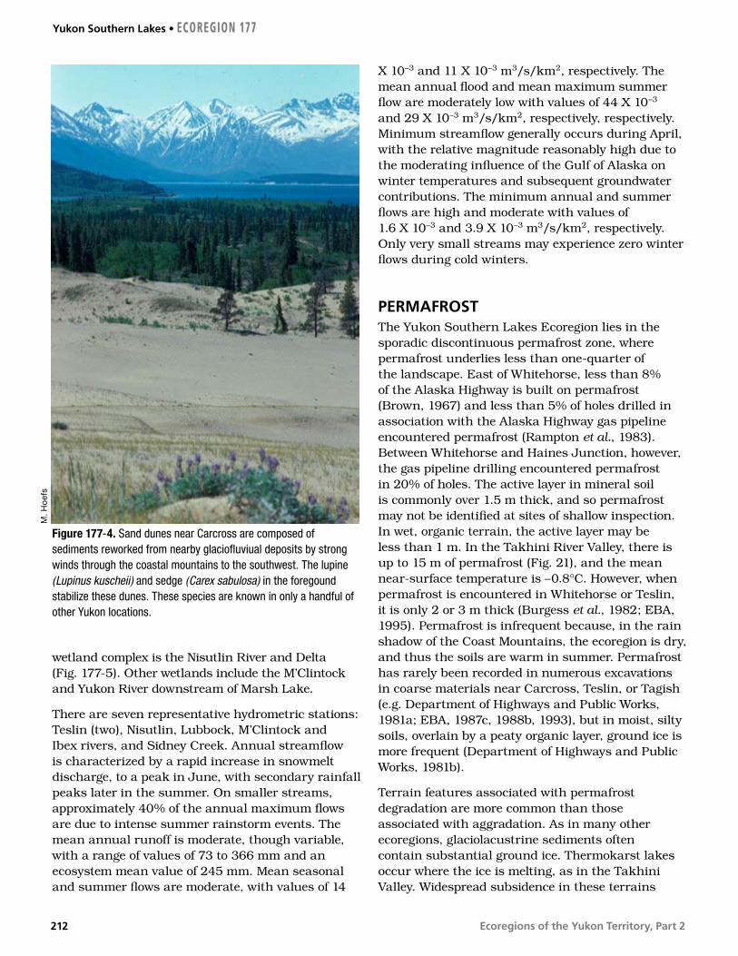
In valleys with southeast to northwest orientation, winds are common because of the proximity of storm centres in the Gulf of Alaska. Strong winds typically range from 30 to 50 km/hr and occasionally reach destructive force with gusts over 100 km/hr, primarily from a southerly direction (Fig. 177-4).
HYDROLOGYThe Yukon Southern Lakes Ecoregion is situated within the Interior Hydrologic Region, although it forms a boundary with the Western Hydrologic Region (Fig. 8). With a total area of approximately 30,000 km2, the ecoregion primarily drains northward from the upland plateau complex consisting of the Teslin and Nisutlin plateaus. The western portion of the ecoregion consists of the footslopes of the Coast Mountains, and as such has greater relief and subsequently higher runoff and peak flows than the central and eastern portion of the ecoregion. Major streams include the Teslin River, which makes up part of the eastern boundary, the upper Yukon River, and the Takhini River. Several smaller, more representative intermediate-sized tributaries of the Yukon include the Nisutlin, Wolf and M’Clintock rivers. The Dezadeash and Aishihik rivers at the western corner flow westward into the Alsek River. Wetlands and large lakes cover approximately 5% of the ecoregion. The ecoregion contains several large lakes including Teslin, Wolf, Marsh and Laberge (Fig. 177-2). The most significant
ECOREGION 177 • Yukon Southern Lakes
211
Ecoregions of the Yukon Territory, Part 2
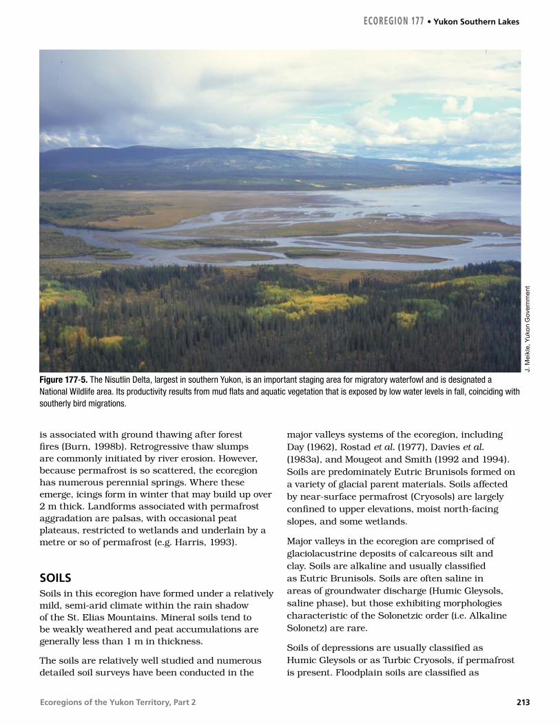
wetland complex is the Nisutlin River and Delta (Fig. 177-5). Other wetlands include the M’Clintock and Yukon River downstream of Marsh Lake.
There are seven representative hydrometric stations: Teslin (two), Nisutlin, Lubbock, M’Clintock and Ibex rivers, and Sidney Creek. Annual streamflow is characterized by a rapid increase in snowmelt discharge, to a peak in June, with secondary rainfall peaks later in the summer. On smaller streams, approximately 40% of the annual maximum flows are due to intense summer rainstorm events. The mean annual runoff is moderate, though variable, with a range of values of 73 to 366 mm and an ecosystem mean value of 245 mm. Mean seasonal and summer flows are moderate, with values of 14
X 10–3 and 11 X 10–3 m3/s/km2, respectively. The mean annual flood and mean maximum summer flow are moderately low with values of 44 X 10–3 and 29 X 10–3 m3/s/km2, respectively, respectively. Minimum streamflow generally occurs during April, with the relative magnitude reasonably high due to the moderating influence of the Gulf of Alaska on winter temperatures and subsequent groundwater contributions. The minimum annual and summer flows are high and moderate with values of 1.6 X 10⁻³ and 3.9 X 10⁻³ m3/s/km2, respectively. Only very small streams may experience zero winter flows during cold winters.
PERMAFROSTThe Yukon Southern Lakes Ecoregion lies in the sporadic discontinuous permafrost zone, where permafrost underlies less than one-quarter of the landscape. East of Whitehorse, less than 8% of the Alaska Highway is built on permafrost (Brown, 1967) and less than 5% of holes drilled in association with the Alaska Highway gas pipeline encountered permafrost (Rampton et al., 1983). Between Whitehorse and Haines Junction, however, the gas pipeline drilling encountered permafrost in 20% of holes. The active layer in mineral soil is commonly over 1.5 m thick, and so permafrost may not be identified at sites of shallow inspection. In wet, organic terrain, the active layer may be less than 1 m. In the Takhini River Valley, there is up to 15 m of permafrost (Fig. 21), and the mean near-surface temperature is –0.8°C. However, when permafrost is encountered in Whitehorse or Teslin, it is only 2 or 3 m thick (Burgess et al., 1982; EBA, 1995). Permafrost is infrequent because, in the rain shadow of the Coast Mountains, the ecoregion is dry, and thus the soils are warm in summer. Permafrost has rarely been recorded in numerous excavations in coarse materials near Carcross, Teslin, or Tagish (e.g. Department of Highways and Public Works, 1981a; EBA, 1987c, 1988b, 1993), but in moist, silty soils, overlain by a peaty organic layer, ground ice is more frequent (Department of Highways and Public Works, 1981b).
Terrain features associated with permafrost degradation are more common than those associated with aggradation. As in many other ecoregions, glaciolacustrine sediments often contain substantial ground ice. Thermokarst lakes occur where the ice is melting, as in the Takhini Valley. Widespread subsidence in these terrains
Figure 177-4. Sand dunes near Carcross are composed of sediments reworked from nearby glaciofluviual deposits by strong winds through the coastal mountains to the southwest. The lupine (Lupinus kuscheii) and sedge (Carex sabulosa) in the foregound stabilize these dunes. These species are known in only a handful of other Yukon locations.
M. H
oef
s
Yukon Southern Lakes • ECOREGION 177
212
Ecoregions of the Yukon Territory, Part 2
is associated with ground thawing after forest fires (Burn, 1998b). Retrogressive thaw slumps are commonly initiated by river erosion. However, because permafrost is so scattered, the ecoregion has numerous perennial springs. Where these emerge, icings form in winter that may build up over 2 m thick. Landforms associated with permafrost aggradation are palsas, with occasional peat plateaus, restricted to wetlands and underlain by a metre or so of permafrost (e.g. Harris, 1993).
SOILSSoils in this ecoregion have formed under a relatively mild, semi-arid climate within the rain shadow of the St. Elias Mountains. Mineral soils tend to be weakly weathered and peat accumulations are generally less than 1 m in thickness.
The soils are relatively well studied and numerous detailed soil surveys have been conducted in the
major valleys systems of the ecoregion, including Day (1962), Rostad et al. (1977), Davies et al. (1983a), and Mougeot and Smith (1992 and 1994). Soils are predominately Eutric Brunisols formed on a variety of glacial parent materials. Soils affected by near-surface permafrost (Cryosols) are largely confined to upper elevations, moist north-facing slopes, and some wetlands.
Major valleys in the ecoregion are comprised of glaciolacustrine deposits of calcareous silt and clay. Soils are alkaline and usually classified as Eutric Brunisols. Soils are often saline in areas of groundwater discharge (Humic Gleysols, saline phase), but those exhibiting morphologies characteristic of the Solonetzic order (i.e. Alkaline Solonetz) are rare.
Soils of depressions are usually classified as Humic Gleysols or as Turbic Cryosols, if permafrost is present. Floodplain soils are classified as
Figure 177-5. The Nisutlin Delta, largest in southern Yukon, is an important staging area for migratory waterfowl and is designated a National Wildlife area. Its productivity results from mud flats and aquatic vegetation that is exposed by low water levels in fall, coinciding with southerly bird migrations.
J. M
eikl
e, Y
uko
n G
over
nmen
t
ECOREGION 177 • Yukon Southern Lakes
213
Ecoregions of the Yukon Territory, Part 2
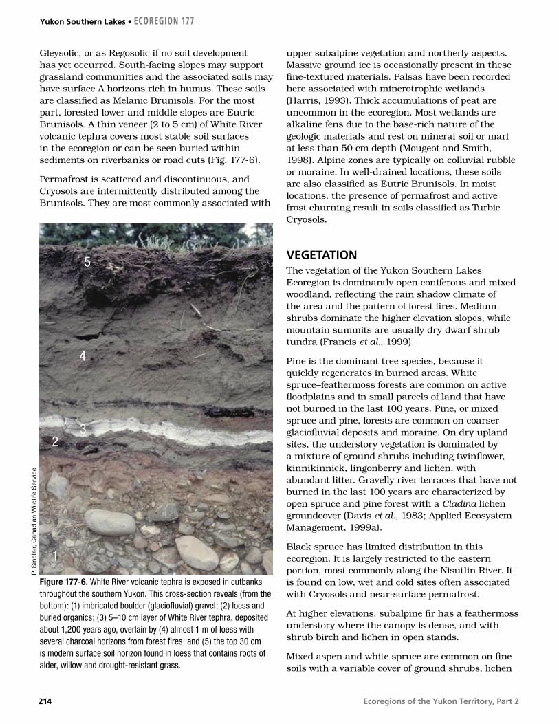
Gleysolic, or as Regosolic if no soil development has yet occurred. South-facing slopes may support grassland communities and the associated soils may have surface A horizons rich in humus. These soils are classified as Melanic Brunisols. For the most part, forested lower and middle slopes are Eutric Brunisols. A thin veneer (2 to 5 cm) of White River volcanic tephra covers most stable soil surfaces in the ecoregion or can be seen buried within sediments on riverbanks or road cuts (Fig. 177-6).
Permafrost is scattered and discontinuous, and Cryosols are intermittently distributed among the Brunisols. They are most commonly associated with
upper subalpine vegetation and northerly aspects. Massive ground ice is occasionally present in these fine-textured materials. Palsas have been recorded here associated with minerotrophic wetlands (Harris, 1993). Thick accumulations of peat are uncommon in the ecoregion. Most wetlands are alkaline fens due to the base-rich nature of the geologic materials and rest on mineral soil or marl at less than 50 cm depth (Mougeot and Smith, 1998). Alpine zones are typically on colluvial rubble or moraine. In well-drained locations, these soils are also classified as Eutric Brunisols. In moist locations, the presence of permafrost and active frost churning result in soils classified as Turbic Cryosols.
VEGETATIONThe vegetation of the Yukon Southern Lakes Ecoregion is dominantly open coniferous and mixed woodland, reflecting the rain shadow climate of the area and the pattern of forest fires. Medium shrubs dominate the higher elevation slopes, while mountain summits are usually dry dwarf shrub tundra (Francis et al., 1999).
Pine is the dominant tree species, because it quickly regenerates in burned areas. White spruce–feathermoss forests are common on active floodplains and in small parcels of land that have not burned in the last 100 years. Pine, or mixed spruce and pine, forests are common on coarser glaciofluvial deposits and moraine. On dry upland sites, the understory vegetation is dominated by a mixture of ground shrubs including twinflower, kinnikinnick, lingonberry and lichen, with abundant litter. Gravelly river terraces that have not burned in the last 100 years are characterized by open spruce and pine forest with a Cladina lichen groundcover (Davis et al., 1983; Applied Ecosystem Management, 1999a).
Black spruce has limited distribution in this ecoregion. It is largely restricted to the eastern portion, most commonly along the Nisutlin River. It is found on low, wet and cold sites often associated with Cryosols and near-surface permafrost.
At higher elevations, subalpine fir has a feathermoss understory where the canopy is dense, and with shrub birch and lichen in open stands.
Mixed aspen and white spruce are common on fine soils with a variable cover of ground shrubs, lichen
Figure 177-6. White River volcanic tephra is exposed in cutbanks throughout the southern Yukon. This cross-section reveals (from the bottom): (1) imbricated boulder (glaciofluvial) gravel; (2) loess and buried organics; (3) 5–10 cm layer of White River tephra, deposited about 1,200 years ago, overlain by (4) almost 1 m of loess with several charcoal horizons from forest fires; and (5) the top 30 cm is modern surface soil horizon found in loess that contains roots of alder, willow and drought-resistant grass.
P. S
incl
air,
Can
adia
n W
ildlif
e S
ervi
ce
1
32
4
5
Yukon Southern Lakes • ECOREGION 177
214

Ecoregions of the Yukon Territory, Part 2
and litter. Willow and soapberry are common. Aspen is also found on steep south-facing slopes, often with small pockets of spruce occupying the moister sites. Balsam poplar is found on roadsides and along creeks and rivers; it is an early invader and usually replaced in the successional sequence by white spruce. Paper birch is scattered on cooler, moister sites, but is neither common nor known to form pure stands.
Open areas at low elevations include grasslands on steep south-facing slopes and alkaline lacustrine depressions, such as those found in the Takhini Valley. Shrub birch is common in moist depressions subject to cold air drainage. Willows dominate fen and marsh wetlands and are common in areas subject to flooding (Oswald and Brown, 1986).
Around treeline, shrub birch, underlain by lichen and moss, takes over the drier sites. On moister and north-facing sites, willow and shrub birch with moss groundcover are more dominant. The alpine dwarf shrub tundra found at higher elevations includes willow, lingonberry, bearberry, bilberry, and mat or cushion plants such as dryas, lichen and graminoids. The vegetation cover is sparse on the most exposed sites.
WILDLIFE
MammalsThe topographically diverse Yukon Southern Lakes Ecoregion supports the highest mammalian diversity in the Yukon with at least 50 of the 60 or more Yukon species. Dall sheep (Barichello et al., 1989a), grizzly bear (Larsen and Markel, 1989), wolves (Hayes et al., 1991), coyotes, red fox, and wolverine (Banci, 1987) are abundant. Wolf and wolverine densities are among the highest in the Yukon. Coyotes invaded the territory in the early 20th century, probably benefiting from widespread wolf control across North America and the ability to outcompete red fox. Coyotes are most abundant in the southern Yukon and range north to the Klondike Plateau and Yukon Plateau–Central. Stone sheep are found east of Lake Laberge.
A long history of overharvesting of moose and caribou populations throughout much of this ecoregion required management programs that restricted human harvest beginning in the 1990s (Larsen et al., 1986, 1989). The Carcross–Squanga,
Ibex and Atlin woodland caribou herds are small and fragmented, estimated at 300, 400, and 800 caribou, respectively. The Carcross–Squanga and Ibex herds are not restricted to smaller winter ranges by snowfall, and therefore expose themselves to more wolf packs. The more remote Wolf Lake caribou herd to the east is considered healthy (Farnell and MacDonald, 1989), with 1400 animals estimated in 1998.
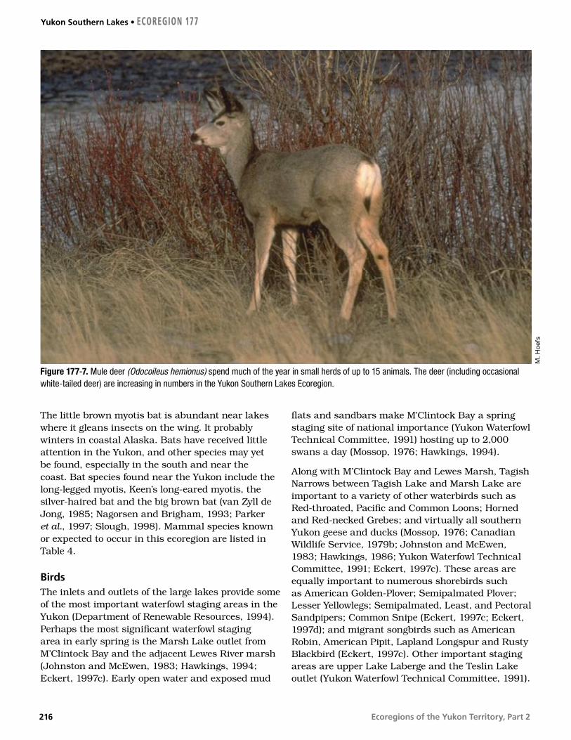
A small population of mountain goats was re-established on White Mountain in 1983–1984 following their extirpation in the 1960s (Barichello et al., 1989b). An elk herd, introduced in the 1950s, with additions for genetic outcrossing in the 1990s, has survived in the Takhini River Valley and numbers about 60. Mule deer are common in this ecoregion and are often seen in small herds of 12 to 15 (Fig. 177-7).
The Teslin burn of 1958 supports some of the highest densities of moose, wolves, snowshoe hare and lynx in the Yukon. The lynx density in 1990–1991 of 45/100 km2 was the highest ever reported in North America (Slough and Mowat, 1996). Beavers are also abundant where burns and wetlands meet, as in the Teslin burn (Slough and Jessup, 1984). Muskrats are still common but once thrived in the Lewes River marsh before flow control, which has altered seasonal water level fluctuations.
The cougar, with the greatest range of any mammal in the Western Hemisphere, makes infrequent movements through this area from northern British Columbia. Marten are uncommon west of the Teslin River; however, a transplant program and natural colonization in the 1980s have increased marten abundance in local climax coniferous habitats, primarily at higher elevations (Slough, 1989).
The northern flying squirrel, bushy-tailed wood rat and woodchuck are uncommonly seen residents. Arctic ground squirrels and least chipmunks flourish in the forest openings and grassy slopes common in the ecoregion. The only know location of the western jumping mouse in the Yukon is on the South Canol Road. The meadow jumping mouse is common throughout the southern Yukon (Youngman, 1975). There is abundant aquatic habitat for water shrew in the ecoregion. The house mouse, originating in mid-eastern Asia and now a world traveler, has taken up residence around the habitations of Whitehorse.
ECOREGION 177 • Yukon Southern Lakes
215
Ecoregions of the Yukon Territory, Part 2
The little brown myotis bat is abundant near lakes where it gleans insects on the wing. It probably winters in coastal Alaska. Bats have received little attention in the Yukon, and other species may yet be found, especially in the south and near the coast. Bat species found near the Yukon include the long-legged myotis, Keen’s long-eared myotis, the silver-haired bat and the big brown bat (van Zyll de Jong, 1985; Nagorsen and Brigham, 1993; Parker et al., 1997; Slough, 1998). Mammal species known or expected to occur in this ecoregion are listed in Table 4.
BirdsThe inlets and outlets of the large lakes provide some of the most important waterfowl staging areas in the Yukon (Department of Renewable Resources, 1994). Perhaps the most significant waterfowl staging area in early spring is the Marsh Lake outlet from M’Clintock Bay and the adjacent Lewes River marsh (Johnston and McEwen, 1983; Hawkings, 1994; Eckert, 1997c). Early open water and exposed mud
flats and sandbars make M’Clintock Bay a spring staging site of national importance (Yukon Waterfowl Technical Committee, 1991) hosting up to 2,000 swans a day (Mossop, 1976; Hawkings, 1994).
Along with M’Clintock Bay and Lewes Marsh, Tagish Narrows between Tagish Lake and Marsh Lake are important to a variety of other waterbirds such as Red-throated, Pacific and Common Loons; Horned and Red-necked Grebes; and virtually all southern Yukon geese and ducks (Mossop, 1976; Canadian Wildlife Service, 1979b; Johnston and McEwen, 1983; Hawkings, 1986; Yukon Waterfowl Technical Committee, 1991; Eckert, 1997c). These areas are equally important to numerous shorebirds such as American Golden-Plover; Semipalmated Plover; Lesser Yellowlegs; Semipalmated, Least, and Pectoral Sandpipers; Common Snipe (Eckert, 1997c; Eckert, 1997d); and migrant songbirds such as American Robin, American Pipit, Lapland Longspur and Rusty Blackbird (Eckert, 1997c). Other important staging areas are upper Lake Laberge and the Teslin Lake outlet (Yukon Waterfowl Technical Committee, 1991).
Figure 177-7. Mule deer (Odocoileus hemionus) spend much of the year in small herds of up to 15 animals. The deer (including occasional white-tailed deer) are increasing in numbers in the Yukon Southern Lakes Ecoregion.
M. H
oef
s
Yukon Southern Lakes • ECOREGION 177
216
Ecoregions of the Yukon Territory, Part 2
The Nisutlin River Delta (Fig. 177-5) is a fall staging area of national importance for swans, geese, dabbling ducks, and diving ducks (Mossop and Coleman, 1984; Yukon Waterfowl Technical Committee, 1991; Hawkings, 1994). While spring water levels are high at the Nisutlin Delta, they decrease in the late summer and fall to expose extensive mud flats and dense beds of aquatic vegetation (Dennington, 1985). The exposed mud flats also provide important feeding areas for many migrant shorebirds including Semipalmated Plover; Lesser Yellowlegs; Semipalmated, Least, Baird’s, and Pectoral Sandpipers; Long-billed Dowitcher; and migrant songbirds such as American Pipit and Lapland Longspur (Eckert, 1997a, 1998a). One of North America’s rarest migrant shorebirds, the Sharp-tailed Sandpiper, is apparently a regular fall migrant here (Eckert, 1997a, 1998a). The large numbers of waterfowl and shorebirds in turn attract numerous predators such as Bald Eagle, Merlin, Peregrine Falcon, and Gyrfalcon (Mossop and Coleman, 1984; Eckert, 1997a, 1998a). Southbound Trumpeter Swans arrive on the delta in mid-September and by late September are greatly outnumbered by large flocks of migrating Tundra Swans, a few of which linger until freeze-up (Mossop and Coleman, 1984; Eckert, 1997a, 1998a).
The lower Nisutlin River is a rare example of a river supporting large numbers of breeding waterfowl (Hawkings, 1994). The river’s abundant cut-off channels, oxbows, and sloughs harbour breeding and moulting Canada Goose, American Widgeon, Mallard, Green-winged Teal, Ring-necked Ducks, scaup, and goldeneye (Dennington, 1985; Hawkings, 1994). Since 1992, these wetlands have hosted the highest density of breeding Trumpeter Swan in the Yukon (Hawkings, 1994). During fall migration from early September to late October, large lakes and other sites that concentrate gulls witness movements of Thayer’s Gull with lesser numbers of Glaucous Gull (Eckert, 1998a; Canadian Wildlife Service, unpubl.).
Larger lakes and rivers support breeding Pacific and Common Loons, Surf Scoter, Mew and Herring Gulls, Arctic Tern, and Belted Kingfisher (Rand, 1946; Godfrey, 1951; Stelfox, 1972; Canadian Wildlife Service, 1979a; Nixon et al., 1992). Numerous wetlands such as Swan Lake (Grunberg, 1994), Rat Lake, Cowley Lake, McIntyre Creek, Mary Lake and Chinook Creek are important to many waterfowl as well as Pied-billed Grebe, Sora, and
American Coot (CWS, Birds of the Yukon Database). McIntyre Creek wetlands are especially important to very large numbers of migrating swallows especially Tree, Violet-green, Northern Rough-winged, Bank, and Cliff Swallows (Eckert, 1997c; Canadian Wildlife Service, unpubl.).
Marshy areas associated with lakes, streams and ponds have breeding Northern Harrier, Lesser Yellowlegs, Solitary and Least Sandpipers, Common Snipe, Wilson’s and Red-necked Phalaropes, Bonaparte’s Gull, Rusty and Red-winged Blackbirds, Northern Waterthrush, Common Yellowthroat, and Savannah and Lincoln’s Sparrows (Grunberg, 1994; Eckert, 1999b; Canadian Wildlife Service, unpubl.). Rocky and sandy lakeshores provide breeding habitat for Semipalmated Plover, Killdeer, Spotted Sandpiper, and Arctic Tern (Johnston and McEwen, 1983; Canadian Wildlife Service, unpubl.), while Harlequin Ducks and American Dippers breed on swift mountain streams (Soper, 1954). Osprey and Bald Eagle nest near lakes and rivers containing spawning fish (Yukon Wildlife Branch, 1977).
Deciduous and mixed forests in riparian areas support breeding Yellow-bellied Sapsucker, Hammond’s Flycatcher, Yellow Warbler, Chipping Sparrow, and Fox Sparrow, with Least Flycatcher occurring locally in trembling aspen forests (e.g. Grunberg, 1994). Ruffed Grouse are year-round residents of trembling aspen forests, while Blue Grouse inhabit subalpine forests (Rand, 1946). Rufous Hummingbirds reach their northern limit in the Southern Lakes Ecoregion although breeding there is unconfirmed (Canadian Wildlife Service, unpubl.).
Open mixed woodland and coniferous forests support raptors such as Northern Goshawk, Red-tailed Hawk, Great Horned Owl, Northern Hawk Owl, Great Gray Owl, and Boreal Owl (Rand, 1946; Godfrey, 1951). Year-round residents include Three-toed, Black-backed, Downy, and Hairy Woodpeckers; Spruce Grouse; Gray Jay; Black-billed Magpie; Common Raven; Black-capped and Boreal Chickadees; Bohemian Waxwing; Pine Grosbeak; and White-winged Crossbill; also, Red Crossbill regularly occur at a few locations (Eckert et al., 1995). Common and Hoary Redpolls occur regularly in winter (Eckert et al., 1995). Common forest species include Olive-sided Flycatcher, Western Wood-Pewee, Ruby-crowned Kinglet, Swainson’s Thrush, American Robin, Varied Thrush, Warbling Vireo, Yellow-rumped Warbler, Blackpoll Warbler,
ECOREGION 177 • Yukon Southern Lakes
217

Ecoregions of the Yukon Territory, Part 2
Dark-eyed Junco, Purple Finch, and in mature spruce forests, Golden Crowned Kinglet (Department of Renewable Resources, 1994; Grunberg, 1994; Eckert et al., 1995; Canadian Wildlife Service, unpubl.). Open country species include Common Nighthawk, Say’s Phoebe, Mountain Bluebird, and Brown-headed Cowbird (Eckert et al., 1995), with Fox and White-crowned Sparrows in shrubby areas (Canadian Wildlife Service, unpubl.)
Alpine areas support Golden Eagle and Gyrfalcon (Foothills Pipe Lines Ltd., 1978; Department of Renewable Resources, 1994). A few Rock and
White-tailed Ptarmigan inhabit these exposed rocky areas, while Willow Ptarmigan are common in subalpine willow and alder shrub (Department of Renewable Resources, 1994). Shrubby subalpine areas also provide breeding habitat for Dusky Flycatcher; Northern Shrike; Townsend’s Solitaire; Wilson’s Warbler; American Tree, Brewer’s, and Golden-crowned Sparrows; and Common Redpoll (Department of Renewable Resources, 1994; Canadian Wildlife Service, unpubl.).
Yukon Southern Lakes • ECOREGION 177
218