Embed Size (px)
Citation preview

IEPERYPRESYPERN
2014
2018
the WWI Salient Centenary
War amidst the castles and country estates
A walk of 3.5 to 7.4 kilometres around Hooge Chateau and Bellewaarde Ridge
Entry point: Hooge Crater Museum ››› The grounds of Hooge ChateauThe wartime landscape of Bellewaarde Ridge ››› Uncommon memorials:
R.E Grave and the Liverpool Scottish Stone ››› Impressive views and panoramasSaint Charles de Potyze Cemetery and Aeroplane Cemetery
Walking folder Ypres Salient-East / Entrance point Hooge Crater Museum
Three entry points in the Ypres SalientThe story of the Great War is told in an interactive and contemporary way in the In Flanders Fields Museum in the Cloth Hall in Ieper. The museum also explains how the landscape has become the last witness of these four terrible years of fighting. To help you to explore this landscape, you can make use of three entry points created along the old front line of the Ypres Salient: in the north at Klein Zwaanhof (Little Swan) Farm); in the east at Hooge Crater Museum; and in the south near Hill 60 and the Palingbeek provincial park. Remembrance trees mark the positions of the two front lines between the entry points.
Ypres Salient cycle routePeople who prefer to explore the old battlefield by bike can follow the Ypres Salient cycle route. This 35-kilometre route starts and ends at the Cloth Hall on the Market Square (Grote Markt) in Ieper. The route links the three entry points: north, east and south. It also passes many other sites of interest related to the First World War. The route folder is available at all local tourist offices and at Hooge Crater Museum.

Hanebeek
Steenbeek
Wijtschatebeek
Bellewaardebeek
BellewaardeVijver
Zillebekevijver
Dikkebus-vijver
Dikkebusvijver-
beek
Yorkshire Trench& Dug-out
Site JohnMcCrae
Hill 62
Hill 60
Reigerburg
Golfclub De Palingbeek
Steenakkermolen
Elzenwalle
ProvinciedomeinGasthuisbossen
ProvinciedomeinPalingbeek
BezoekerscentrumDe Palingbeek
Hooge CraterMuseum
Bellewaardepark1.
2.
3.
4.
AstrolabIris
5.
Vrijbosroute
CaterpillarCrater
6.
Pilkem Ridge
CanadeesMonument
CalvaireBreton
KraterSt.-Elooi
KANAAL IEPER-KOMEN
Bedford HouseCemetery
St. Julien DressingStation
Ieper-Noord
Princess Patricia’sCanadian Light Infantry monument
Hoorn-werkpark
Welsh Memorial
Het Sas
DeKazematten
N345
N37
N366
N331
N375
N308
N8
N369
N38
N313
N332
N313
KANAAL IEPER-IJZER
BellewaardeRidge
The Bluff
Liverpool Scottish Stone
Captains Bowlby & Skrine
Kasteelhof‘t Hooge
Hooge CraterCemetery
Saint Charlesde Potyze
AeroplaneCemetery
P
P
P
P
Hedge RowTrench
Cemetery
First DCLICemetery/The Bluff
WoodsCemetery
Larch WoodCemetery
Sluis
Caesar’s Nose
Colne ValleyCemetery
P
START
LANGEMARK-POELKAPELLE
Voormezele
Boezinge
Zillebeke
IEPER
Krommenelst
Vierstraat
Hoge Voute
Zandberg
Fortuinhoek
Sebastopol
Blatezak
Hemelrijk
Vijfwegen
Kanonhoek
‘t Hoge
Brielen
Hogebos
Groenenburgbos
Molenbos
Vierlingen
Zwarte Leen
Hollebeke
NatuurdomeinVerdronken Weide
Huikerbossen
Papenelst
Tortelbos
Sint - Juliaan
Sint-Jan
Hagebos
Pilkem
Sint-Elooi
Katteputten
Sint-Elooisweg
Rijse
lsewe
g
Arme
ntiers
eweg
Eekhofstraat
Palingbee
kstraa
t
Vaartstraat
Bernikkewallestraat
Vaartstraat
Verbrandemolenstraat
Palingbeekst
raat
Komenseweg
Zwarteleenstr.
Werviksestraat
Papp
otstra
at
Zandvoordsestraat
Pappotstr.
Canadalaan
Meenseweg
Begijnen
boss
traat
Oude Kortrijkstraat
Oude Bellewaardestraat
Zonnebeekseweg
Wieltjesstraat
Wielt
je
Kattestraat
Moortelweg
Briek
estra
at
Moortelweg
Pilke
msew
eg
K leine Poezelstraat
Kleine Poezelstraat
Langemarkseweg
Noorderring
Westkaaipad
Westkaai
Brugseweg
Elverdingestraat
Tulpenlaan
Bijlanderpad
Kalle
putst
raat
Grote Markt
Ledwidgepad
Oostkaai
Wieltje
Begijnenbos
Hogeziekenweg
Diependalebeek
Molenbosstraa
t
Oude Vaart
Oostkaai
RE Grave Application Ypres Salient 1914 - 1918The free application Ypres Salient 1914-1918 indicates the position of all the remembrance trees and makes suggestions for different walks from the three entry points. The trees emit a signal that allows you to locate the position of the front line on a map and on aerial photographs on your cell phone. Highly recommended!
The application is available in the App Store and Google Play. There is WIFI at entry point North.
Remembrance treesAlong the Ypres Salient-East walking route 20 (out of a total of 140) remembrance trees have been planted at points where the old front line crosses a (public) path or road. You can recognize these trees by the coloured metal protectors around their trunks. The red protectors indicate the German line; the blue protectors the French and/or British line. These were the colours used on the maps of the front during the war. Most of the trees have an info-board showing the position of the opposing lines, with a photo from the war years.
The remembrance trees are elms, a type that was common in the countryside around Ieper from many centuries. As a result of the war and Dutch elm disease, nearly all the old elms have now disappeared. The planting of new and more resistant elms as remembrance trees is also a way of restoring this beautiful species to its rightful position in the landscape.

Walking circuits: Ypres Salient-EastDuring this walk, which consists of three interconnected circuits, you will discover three of the most important wartime heritage sites in the old Ypres Salient: the grounds of Hooge Chateau (0.6 km), the wartime landscape on Bellewaarde Ridge (2.3 km) and two cemeteries on the road to Zonnebeke (Zonnebeekseweg) (4.3 km). The total distance is 7.4 km, but you can follow the three circuits separately. Sturdy footwear is recommended. The paths to be followed are less well suited to wheelchairs, prams and buggies. Dogs must be kept on a lead.
At the entry point outside the museum a fascinating film tells how the front in this part of the Ypres Salient moved backwards and forwards as the war progressed. A series of info-panels provide background information on the chateaus and castles that were destroyed in this eastern part of the Salient during the war years.
Hooge Crater Museum
EAST
The walk starts at Hooge Crater Museum, Meenseweg 467 in Zillebeke, near to the Bellewaerde Theme Park. This is also the location of entry point Ypres Salient-East, which has been installed in the renovated sanitary block of the local school that was once housed here.
Hooge Crater Museum now occupies the chapel and school that once served the local com-munity in the hamlet of ’t Hoge, more generally known as Hooge in English. The school was built in 1922 by the lord of the manor, Baron Gaston de Vinck. The chapel followed five years later. The family coat of arms - five finches and three bells - can still be seen above the chapel door. The school was closed in June 1974, but was given a new lease of life in 1994 when it was turned into a museum and cafe. It now contains authentic reconstructions of a number of wartime scenes, together with a unique collection of artefacts, documents, photos and even a film from 1917.
Adress: Hooge Krater MuseumMeenseweg 467 - 8902 Zillebeke
Entry point
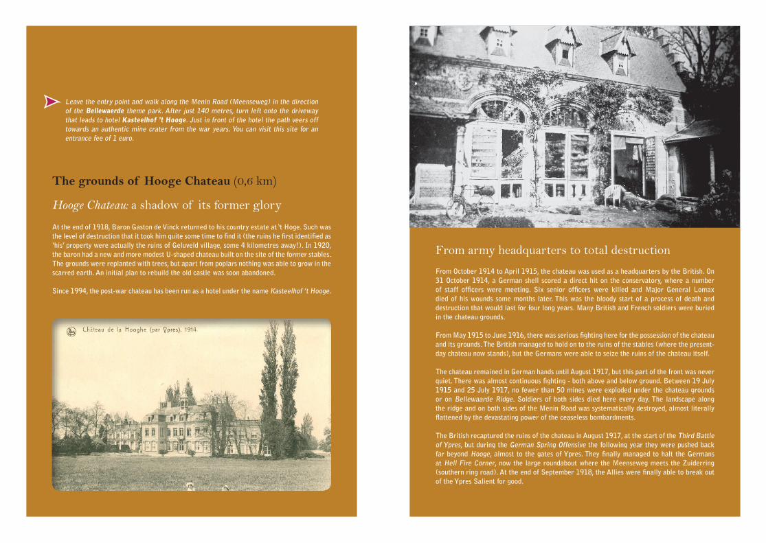
Leave the entry point and walk along the Menin Road (Meenseweg) in the direction of the Bellewaerde theme park. After just 140 metres, turn left onto the driveway that leads to hotel Kasteelhof ’t Hooge. Just in front of the hotel the path veers off towards an authentic mine crater from the war years. You can visit this site for an entrance fee of 1 euro.
From army headquarters to total destruction
From October 1914 to April 1915, the chateau was used as a headquarters by the British. On 31 October 1914, a German shell scored a direct hit on the conservatory, where a number of staff officers were meeting. Six senior officers were killed and Major General Lomax died of his wounds some months later. This was the bloody start of a process of death and destruction that would last for four long years. Many British and French soldiers were buried in the chateau grounds.
From May 1915 to June 1916, there was serious fighting here for the possession of the chateau and its grounds. The British managed to hold on to the ruins of the stables (where the present-day chateau now stands), but the Germans were able to seize the ruins of the chateau itself.
The chateau remained in German hands until August 1917, but this part of the front was never quiet. There was almost continuous fighting - both above and below ground. Between 19 July 1915 and 25 July 1917, no fewer than 50 mines were exploded under the chateau grounds or on Bellewaarde Ridge. Soldiers of both sides died here every day. The landscape along the ridge and on both sides of the Menin Road was systematically destroyed, almost literally flattened by the devastating power of the ceaseless bombardments.
The British recaptured the ruins of the chateau in August 1917, at the start of the Third Battle of Ypres, but during the German Spring Offensive the following year they were pushed back far beyond Hooge, almost to the gates of Ypres. They finally managed to halt the Germans at Hell Fire Corner, now the large roundabout where the Meenseweg meets the Zuiderring (southern ring road). At the end of September 1918, the Allies were finally able to break out of the Ypres Salient for good.
At the end of 1918, Baron Gaston de Vinck returned to his country estate at ‘t Hoge. Such was the level of destruction that it took him quite some time to find it (the ruins he first identified as ‘his’ property were actually the ruins of Geluveld village, some 4 kilometres away!). In 1920, the baron had a new and more modest U-shaped chateau built on the site of the former stables. The grounds were replanted with trees, but apart from poplars nothing was able to grow in the scarred earth. An initial plan to rebuild the old castle was soon abandoned.
Since 1994, the post-war chateau has been run as a hotel under the name Kasteelhof ’t Hooge.
The grounds of Hooge Chateau (0,6 km)
Hooge Chateau: a shadow of its former glory

A wartime site rubs shoulders with a theme park Walk to Bellewaarde Ridge (2,8 km)
Follow the path through the former chateau grounds. This path was made with the concrete blocks that the Germans used to construct their bunkers during the war.
After visiting the crater site, return to the Meenseweg. When you are back at the entry point, turn into the Bellewaerdestraat. This old lane leads down to the Bellewaerde brook and Bellewaarde Farm, which was originally part of the chateau estate. Three remembrance trees mark the German front line.
The lake was ‘created’ on 6 June 1916 by the detonation of four German mines under the British front line. After the explosions, the German infantry advanced and captured the craters and the British trenches. Just beyond the lake there is a German bunker. As you walk, you will note the typical zig-zag pattern of the trenches, the shelters made from corrugated elephant sheeting, the rolls of barbed wire, the spiral-shaped wire pickets (known as pig-tails), narrow gauge railway lines and the general detritus of war.
In 1924, the de Vinck family built a second mansion on the eastern side of the estate, which they called Bellewaerde after the medieval manor of the same name. In 1954, this mansion and 6 hectares of land were turned into a bird park. This eventually grew into the popular Bellewaerde Safari Park, which, following several extensions and transformations, is now the Bellewaerde Theme Park.
The mine explosion at Hooge Crater
At the start of the Bellewaerdestraat, next to the entry point, the British detonated a huge mine on 19 July 1915. This explosion created the infamous Hooge Crater. From their lower position on the other side of the Menin Road, the British tunnellers had driven a gallery under the German front line trench. However, the British attack after the detonation progressed not much further than the crater itself. On 30 and 31 July 1915, the Germans hit back with a vengeance, using a terrible new weapon of war: flamethrowers. Faced with this onslaught, the British fell back, but attacked again on 9 August, seizing the crater, the chateau and part of the chateau grounds. But even then the fighting at Hooge was not yet over. On 6 June 1916, the Germans fired new mines and captured Hooge and Hill 62. After the war, Hooge Crater was filled in, so that the Bellewaerdestraat could again be used as a public road.
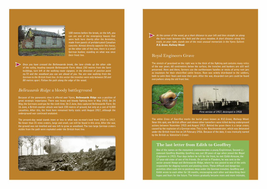
100 metres before the brook, on the left, you can see one of the emergency houses that were built here shortly after the Armistice, made from panels of prefabricated Canadian concrete. Almost directly opposite this house, on the other side of the lane, there is a small German bunker, standing on what was once their front line.
Once you have crossed the Bellewaerde brook, the lane climbs up the other side of the valley, heading towards Bellewaarde Farm. About 150 metres from the farm buildings, turn left at the walking route signpost, in the direction of junction point no.72 and the woodland you can see ahead of you. You are now walking from the German to the British front line. In this sector the trenches were only between 50 and 80 metres apart. Follow the path along the edge of the wood.
Bellewaarde Ridge: a bloody battleground
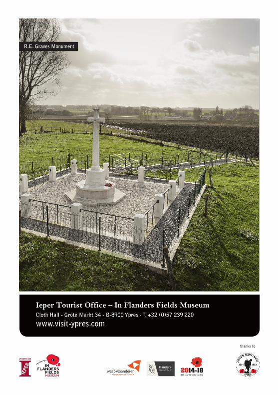
At the corner of the wood, go a short distance to your left and then straight on along the farm track between the field and the grass meadow. A short distance along this track, on your right, stands one of the most unusual memorials in the Ypres Salient: R.E. Grave, Railway Wood.
Because of the panoramic view it offered over Ypres, Bellewaarde Ridge was a position of great strategic importance. There was heavy and bloody fighting here in May 1915. On 24 May, the Germans used gas for the sixth time. On 2 June, they captured Bellewaarde Farm. On 16 June, a British counter attack won back 150 metres of ground, but only at a cost of 4,000 casualties. After this, the front here remained fairly static until August 1917, although the underground war continued unabated.
The present-day wood stands more or less in what was no-man’s-land from 1915 to 1917. No fewer than 21 mine craters, large and small, can still be found in this area. After the war, the ground was not levelled and was left to grow as woodland. The two large German craters visible from the path were exploded under the British front line.
The stretch of grassland on the right was in the thick of the fighting and contains many relics of the war years. 60 centimetres below the surface, the trenches and bunkers are still well preserved. Here and there, farmers use the earthenware handles or necks of army rum jars as insulators for their electrified cattle fences. Rum was widely distributed to the soldiers, both to calm their fears and ease their pain. After the war, discarded rum jars could be found everywhere along the old front line.
The white Cross of Sacrifice marks the burial place known as R.E.Grave, Railway Wood. Near this spot, one British officer and eleven other tunnellers were killed during underground actions between November 1915 and August 1917. Behind the grave there is a large crater, caused by the explosion of a German mine. This is the Roschmannkrater, which was detonated under the British front line on 14 February 1916. Because of the date, it was ironically named by the British as Valentine’s Crater.
Royal Engineers Grave
The last letter from Edith to GeoffreyOne of the names on the monument commemorates a young Englishman, Second Li-eutenant Geoffrey Boothby. Geoffrey was just 20 years of age when joined the Royal Engineers in 1915. Four days before he left for the front, he met Edith Ainscow, the 17-year-old sister of one of his friends. On arrival in Flanders, he was sent to the sector around Hooge and Bellewaarde Ridge, where he was posted to one of the units responsible for digging tunnels and planting mines. These difficult and dangerous activities often took him to positions deep under the German trenches. Geoffrey and Edith wrote to each other for 18 months, encouraging each other and describing their hopes and fears for the future. The letters gradually became more and more intimate,
First version of 1917, destroyed in 1918

until they eventually fell deeply in love. When it seemed that Geoffrey might get home leave, Edith wrote in May 1916: I can hardly believe that you are coming, but I keep on hope, hope, hoping that it might be true. Please be careful during the next week. It was her last letter, and it was never answered by Geoffrey... He had already been killed on 28 April 1916 during an underground action at Bellewaarde Ridge. And there he lies still, with a photo of Edith in his breast pocket, his name recorded in perpetuity on the panels of R.E. Grave.
Because the Begijnenbos (Beguine Wood) was situated near the railway line from Ieper to Roeselare (the route now followed by the Zuiderring or southern ring road), it was known by the British as Railway Wood. The Germans called it Eierwäldchen. The wood was just inside the British lines and was filled with underground shelters, providing quarters for thousands of troops and a first aid post. From here, tunnels ran out under no-man’s-land, some of them stretching as far as the German front line.
The sharp bend in the Oude Kortrijkstraat, just beyond the wood, stands on the raised rim of one of the earliest craters on Bellewaarde Ridge: the Leuthold or Bliss Crater. This was detonated on 25 September 1915 at the start of a large-scale diversionary attack by the British, designed to draw German attention away from a major offensive launched at Loos (in northern France) the same day. The British briefly captured Bellewaarde Farm, but were forced to pull back later in the evening. Some 1,600 men were killed in the fighting. The crater was filled in 1983.
Walk to the Zonnebeke Road: Saint Charles dePotyze Cemetery and Aeroplane Cemetery (4,3 km)
Begijnenbos or Railway Wood: a British fortress
For the longer circuit (4.3 km), carry on walking to the Oude Kortrijkstraat and turn left in the direction of the Begijnenbos (Beguine Wood). Here, you have a fine view of the rest of the Ypres Salient. Remembrance trees mark the front line. For the shorter circuit (2.8 km) return to the crater wood. The return route is described from the Liverpool Sciottish Stone (see further).
The Oude Kortrijkstraat eventually joins the Begijnenbosstraat. Turn right at the junction and carry on to the Zuiderring. Be careful when crossing this busy road.
Captains Bowlby and Skrine160 metres further along the Begijnenbosstraat stand two memorials to two British captains. Captain Bowlby died on 13 May 1915 during a bloody but ultimately unsuccessful counter-attack to regain lost positions around Bellewaarde Farm. 40 officers and 280 men were killed; almost 1,400 hundred others were wounded or missing.
Captain Skrine died along with two officers and 11 other ranks of his battalion during the fighting on 25 September 1915, near Bellewaarde. His grave, like Bowlby’s, was lost in later fighting. Both men are commemorated by name on the Menin Gate Memorial. The memorials here were erec-ted by their families. Next to those monuments, a remem-brance stone for the Leicestershire Yeomanry Regiment was established in 2015.
The Begijnenbosstraat follows the position of the British second line. The front line was 250 metres further east. After 1 kilometre, you arrive at the Zonnebeekseweg, with Saint Charles de Potyze French Military Cemetery on your right.
This is the largest French military cemetery in Belgium, with more than 4,600 graves, 762 of which are unknown. The 69 Muslim graves are easily identified by their elegant headstones. A further 616 unidentified soldiers are buried in a mass grave. At the front of this sober cemetery stands a Calvary; at the back, there is an obelisk with a number of commemorative plaques. The cemetery was started in November 1914 in the garden of a local school (Saint Charles de Potyze) that was used as a first aid post. For much of the war, it was just behind the British front line. As a result, many of the original graves from 1914 and 1915 were destroyed by later shelling. After 1919, the cemetery was renovated and expanded. The remains of French soldiers discovered during public works or archaeological excavations are now buried at the rear of the site.
Saint Charles de Potyze

Keep on walking beyond the cemetery. You will soon pass trees marking the British and German front lines. Between them stands a Commonwealth war cemetery.
Carry on along the Zonnebeekseweg and turn right into the Oude Bellewaardestraat, passing a row of remembrance trees. After 900 metres, you will once again cross the busy Zuiderring. Carry straight on until you reach the Oude Kortrijkstraat. Turn right, where you will get another fine view of the rolling landscape of Bellewaarde Ridge. After 300 metres, turn left onto the farm track leading back to the crater wood. Pass R.E. Grave and turn onto the path leading through the woods to the left, where you will see the monument to the Liverpool Scottish.
When the path reaches the edge of the wood, carry on to the left, until you arrive back at the Bellewaerdestraat. Along the way, you can enjoy the beauty of the gently rolling valley landscape, with its views of the wooded ridges of the Ypres Salient and the hill country beyond. The road eventually climbs back up the slope to the starting point at Hooge Crater Museum (entry point – East) along the Meenseweg. On the other side of the Meenseweg (be careful when crossing the road!) stands Hooge Crater Cemetery.
Walk further through the crater wood, along the path to the right behind the monument. You will eventually cross over the main (private!) track. Continue walking through the wood.
This cemetery was started on 31 July 1917, the first day of the Third Battle of Ypres. Before the battle, the site of the cemetery stood in no-man’s-land. Those who were killed during the fighting were buried here. When a British aeroplane crashed nearby some weeks later, the cemetery was given its name. Many graves collected from the battlefields were added after the Armistice. In total, the cemetery now contains 1,105 burials, 469 of which are unidentified. The casualties come from the United Kingdom, Australia, Canada, New Zealand and South Africa (one).
The monument at the edge of the crater wood was erected in 2000 to commemorate the 100th anniversary of the founding of the 10th Battalion of the King’s Regiment, known as the Liverpool Scottish. The upright stone that forms part of the monument is the keystone that was originally above the entrance gates to their barracks in Liverpool. After the barracks was demolished, the stone was gifted to the City of Ieper. The monument commemorates the dramatic attack by the battalion at this spot on 16 June 1915, when 542 Scottish volunteers attempted to storm the German positions on Bellewaarde Ridge. Only 132 of them remained unharmed at the end of the day. 79 were killed, 109 were missing (later presumed dead) and 222 were wounded.
Between 17 October 1915 and 27 July 1917 no fewer than 33 deep mines were exploded
This Commonwealth cemetery is situated on the slopes of the ridge and was designed by the famous British landscape architect, Sir Edwin Lutyens. It is one of the most beautiful British cemeteries in the Ypres Salient. The circular depression containing the Stone of Remembrance near the entrance is a reference to the wartime Hooge Crater, which was created by a mine blown just across the road in 1915. The cemetery was started in October 1917 and originally contained just 76 graves. It was extended after the war and is now the last resting place of 5,922 victims of the Great War, 3,578 of whom are unidentified - a testimony to the vicious fighting that took place near here. As well as 5,183 soldiers from the United Kingdom, there are 513 Australians, 105 Canadians and 121 New Zealanders.
Aeroplane Cemetery
Liverpool Scottish Stone
Walking through the crater wood
Hooge Crater Cemetery
on Bellewaarde Ridge. The most mines were detonated during the first half of 1917, under the high-er lying fields. The path leading through the woods takes you past 13 of the resulting craters.
Blakely Crater at the edge of the wood was blown on 9 March 1917. A little further on, Momb-er Crater (Allenstein for the Germans) is the largest crater in the wood. Detonated on 29 May 1917, it has a diameter of 50 me-tres and a depth of 8 metres. The Germans used its well-preserved rim as the site for a launching pad for their V1 rockets towards the end of the Second World War, but it was never used.
Ieper Tourist Office – In Flanders Fields MuseumCloth Hall - Grote Markt 34 - B-8900 Ypres - T. +32 (0)57 239 220
www.visit-ypres.com
thanks to
R.E. Graves Monument