Embed Size (px)
Citation preview
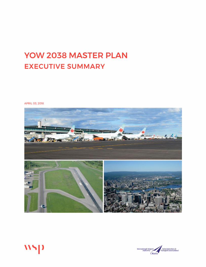
YOW 2038 MASTER PLAN EXECUTIVE SUMMARY
APRIL 03, 2018

YOW 2038 Master Plan Executive Summary Page ii
YOW 2038 Master Plan Executive Summary Page iii
TABLE OF CONTENTS
1 INTRODUCTION ....................................................... 1
1.1 Master Plan Development Process ....................................... 1
1.2 Socio-Economic Profile ........................................................... 2
1.3 Airport History .......................................................................... 3
2 AVIATION ACTIVITY AND FORECASTS ................. 4
2.1 Passenger Activity Forecasts ................................................. 4
2.2 Air Cargo .................................................................................... 5
3 AIRPORT INFRASTRUCTURE ................................. 6
3.1 Existing Facilities ..................................................................... 6
3.1.1 Runways .................................................................................................................. 6
3.1.2 Taxiways and Aprons ............................................................................................ 6
3.2 Airfield Capacity ....................................................................... 7
3.3 Passenger Terminal Building ................................................. 9
3.3.1 Check-in .................................................................................................................. 9
3.3.2 Gates ...................................................................................................................... 10
3.3.3 Pre-board Passenger Screening ....................................................................... 10
3.3.4 Pre-board Screening Requirements ............................................................... 11
3.3.5 Passenger Terminal Development Recommendations.............................. 11
3.4 Groundside .............................................................................. 12
4 DEVELOPMENT PLAN AND COSTS ..................... 13
5 LAND USE PLAN .................................................... 15
5.1 Land Use Designations .......................................................... 15
5.2 Land Use Plan Summary ....................................................... 17
YOW 2038 Master Plan Executive Summary Page 1
1 INTRODUCTION This report summarizes the Ottawa International Airport Master Plan (YOW 2038) which was initiated in May 2017 and completed February 2018. The Plan is a guide for a strategic approach to the future of the Ottawa Macdonald-Cartier International Airport (YOW) by way of a 20-year development framework which outlines the recommended use and development of airport lands and facility upgrades. Assumptions were based on current and future needs and industry trends supported by research, analyses and stakeholder consultations. Development and infrastructure recommendations provided in YOW 2038 are aligned to specified planning horizons:
Primary planning horizon – 2018 - 2030 Secondary planning horizon – 2031 – 2038
The Master Plan positions the Ottawa Macdonald-Cartier International Airport Authority (OMCIAA or the Authority) to satisfy Section 7.01 of the Ground Lease with Transport Canada which requires the Plan to be updated approximately every 10 years.
1.1 MASTER PLAN DEVELOPMENT PROCESS The four-phase process employed to develop YOW 2038 is illustrated in Table 1.1. The master planning process used a participatory approach which elicited the opinions and visions of stakeholders on airport operations and future development at the facility.
Table 1.1 – Four-Phase Process
PHASE TASKS
Phase 1 – Data Assembly and Review - Background Research & Analysis - Existing Conditions - Existing Environmental Impacts from Airport
Operations & Activities - Airport Role - Aviation Industry Trends - Regional & Economic Content / Socio-Economic
Profile
Stak
ehol
der
Cons
ulta
tion
s
Phase 2 - Demand, Capacity Assessment & Requirements
- Update Aviation Forecasts - Airfield Requirements - Airside Business Requirements - Passenger Terminal Requirements - Ground Transportation & Parking Requirements
Phase 3 – Airport Growth – Formulate & Evaluate Development Options
- Airfield Development Options - Passenger Terminal Development Options - Ground Transportation Development Options - Recommended Development Plan
Phase 4 – Recommended Spatial & Land Use Alternative
- Noise Management Plan - Recommended Operational & Business Direction - Land Use Plan
The stakeholder engagement program involved the use of social media, project branding, a dedicated project website, public meetings, questionnaires and interviews.
YOW 2038 Master Plan Executive Summary Page 2
Four key themes were prevalent in the stakeholder feedback:
1. a desire for enhanced airport facilities, such as more passenger terminal building concessions;
2. an appetite for additional flights to Europe and other southern destinations;
3. a desire for improved landside access including the need for future Light Rail Transit (LRT) connectivity at YOW; and
4. the requirement for a future airport terminal hotel.
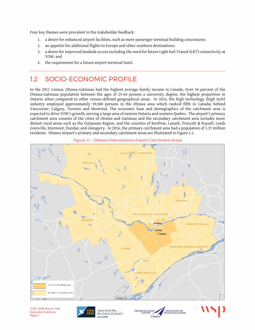
1.2 SOCIO-ECONOMIC PROFILE In the 2011 Census, Ottawa-Gatineau had the highest average family income in Canada. Over 44 percent of the Ottawa-Gatineau population between the ages of 25-64 possess a university degree, the highest proportion in Ontario when compared to other census-defined geographical areas. In 2016, the high technology (high tech) industry employed approximately 59,500 persons in the Ottawa area which ranked fifth in Canada; behind Vancouver, Calgary, Toronto and Montreal. The economic base and demographics of the catchment area is expected to drive YOW’s growth, serving a large area of eastern Ontario and western Quebec. The airport’s primary catchment area consists of the cities of Ottawa and Gatineau and the secondary catchment area includes more distant rural areas such as the Outaouais Region, and the counties of Renfrew, Lanark, Prescott & Russell, Leeds Grenville, Stormont, Dundas; and Glengarry. In 2016, the primary catchment area had a population of 1.37 million residents. Ottawa Airport’s primary and secondary catchment areas are illustrated in Figure 1.1.
Figure 1.1 – Ottawa International Airport Catchment Areas
YOW 2038 Master Plan Executive Summary Page 3
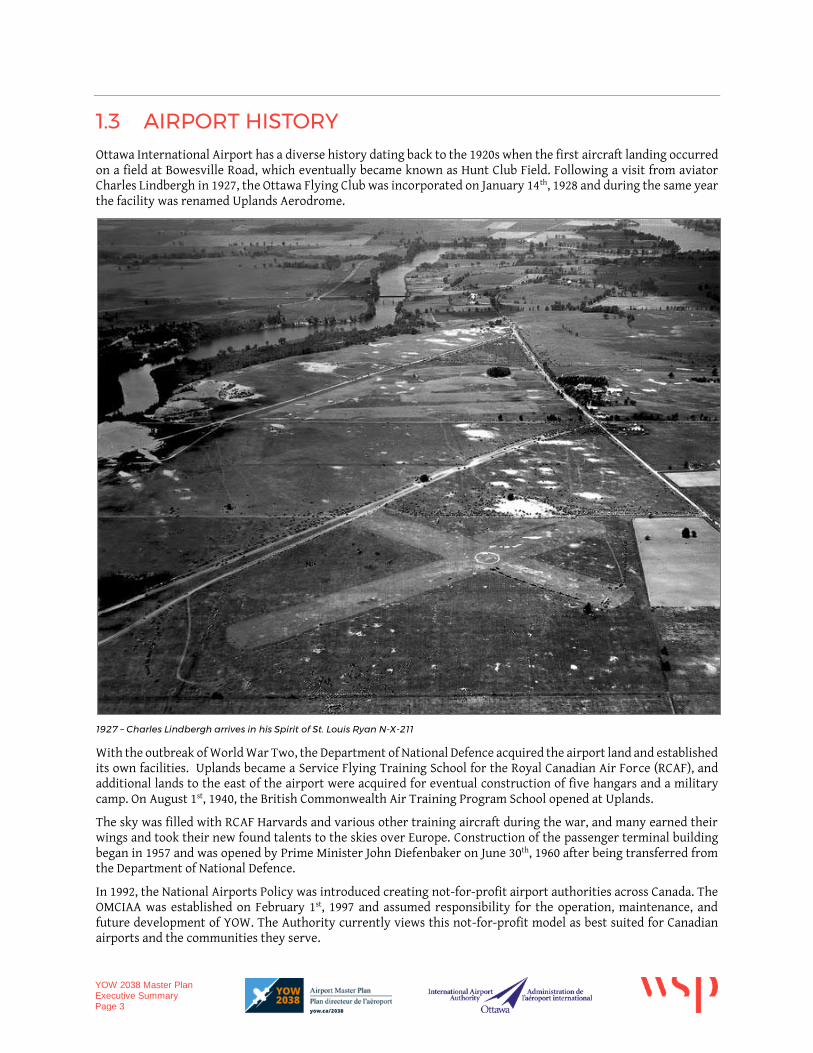
1.3 AIRPORT HISTORY Ottawa International Airport has a diverse history dating back to the 1920s when the first aircraft landing occurred on a field at Bowesville Road, which eventually became known as Hunt Club Field. Following a visit from aviator Charles Lindbergh in 1927, the Ottawa Flying Club was incorporated on January 14th, 1928 and during the same year the facility was renamed Uplands Aerodrome.
1927 – Charles Lindbergh arrives in his Spirit of St. Louis Ryan N-X-211
With the outbreak of World War Two, the Department of National Defence acquired the airport land and established its own facilities. Uplands became a Service Flying Training School for the Royal Canadian Air Force (RCAF), and additional lands to the east of the airport were acquired for eventual construction of five hangars and a military camp. On August 1st, 1940, the British Commonwealth Air Training Program School opened at Uplands.
The sky was filled with RCAF Harvards and various other training aircraft during the war, and many earned their wings and took their new found talents to the skies over Europe. Construction of the passenger terminal building began in 1957 and was opened by Prime Minister John Diefenbaker on June 30th, 1960 after being transferred from the Department of National Defence.
In 1992, the National Airports Policy was introduced creating not-for-profit airport authorities across Canada. The OMCIAA was established on February 1st, 1997 and assumed responsibility for the operation, maintenance, and future development of YOW. The Authority currently views this not-for-profit model as best suited for Canadian airports and the communities they serve.
YOW 2038 Master Plan Executive Summary Page 4
2 AVIATION ACTIVITY AND FORECASTS The Ottawa International Airport currently serves 46 nonstop destinations across Canada and internationally. In 2017, the number of nonstop flights from YOW were 80 daily domestic; 20 daily Transborder; and 23 weekly international flights.
The Master Plan refers to core and derived forecasts. The core forecasts include domestic, transborder and international route segments; illustrating projections of future airport throughput in Enplaned/Deplaned (E/D) passengers and portraying future values of the airport’s traffic. Derived forecasts include transborder sun forecasts, transborder intercity, transborder passengers via other Canadian gateways, international Mexico/Caribbean and international transatlantic route segments. The demand forecasts were either developed as extensions to, or intermediate by-products of, the core forecasts. The demand forecasts enhance the accuracy of the core forecasts, highlight the principal economic factors affecting the airport, illustrate key marketing issues and provide a basis for sensitivity analysis.
The forecasting models associated with the Master Plan employed data as recent as 2016 to identify relationships between key variables. The 2017 base year incorporates data for 2016 and for January-July 2017.
2.1 PASSENGER ACTIVITY FORECASTS Between 2011 and 2015, Ottawa International Airport’s domestic traffic grew at 1.10% per annum. Under the medium growth forecast scenario, the domestic traffic is expected to grow by 2.79% annually between 2016 and 2020. Transborder traffic grew at 0.27% between 2011 and 2015 and under the medium growth scenario, the traffic segment is expected to decline by 0.07% between 2016 and 2020.
Within the same time period, international traffic at YOW decreased by 0.59 percent per annum. Medium growth transatlantic forecasts call for a nominal growth rate of 0.85% annually. Under the same growth scenario, southern traffic to the U.S. and Caribbean destinations is expected to increase from approximately 180,000 passengers in 2017 to approximately 335,000 passengers by 2030.
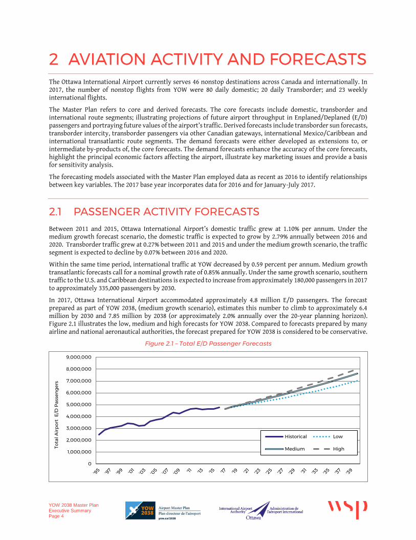
In 2017, Ottawa International Airport accommodated approximately 4.8 million E/D passengers. The forecast prepared as part of YOW 2038, (medium growth scenario), estimates this number to climb to approximately 6.4 million by 2030 and 7.85 million by 2038 (or approximately 2.0% annually over the 20-year planning horizon). Figure 2.1 illustrates the low, medium and high forecasts for YOW 2038. Compared to forecasts prepared by many airline and national aeronautical authorities, the forecast prepared for YOW 2038 is considered to be conservative.
Figure 2.1 – Total E/D Passenger Forecasts
0
1,000,000
2,000,000
3,000,000
4,000,000
5,000,000
6,000,000
7,000,000
8,000,000
9,000,000
Tota
l Air
po
rt E
/D P
asse
ng
ers
Historical Low
Medium High
YOW 2038 Master Plan Executive Summary Page 5
2.2 AIR CARGO The Ottawa International Airport is home to several air cargo facilities that support air mail, air express and general air freight. Air mail is defined as the delivery of letters, packages and other goods shipped via traditional delivery (i.e. Canada Post) and is typically shipped within the cargo holds of scheduled passenger service aircraft, and through contracted agreements with air freight operators.
Air express is defined as cargo shipments by dedicated air cargo couriers, such as FedEx, UPS, DHL and Purolator. Furthermore, general air freight includes a diverse range of products, including machinery, pharmaceuticals, perishable goods, live animals, cut flowers, automotive parts, etc. General air freight occupies empty space in the cargo hold of passenger aircraft, or is transported on dedicated cargo aircraft.
The 50-100 seat turboprop and regional jet aircraft that provides most of the passenger airline flights at Ottawa International Airport have a negligible capacity for air cargo. However, Cargojet offers main deck, palletized service to its hub in Hamilton. This service depends solely on revenues from air cargo, and therefore requires shipments with high unit revenues. Canadian North and First Air operate Boeing 737 aircraft to Iqaluit; occasionally Cargojet operates a B767 to Iqaluit from YOW.
In addition, FedEx offers all-cargo flights to its hub in Memphis, Tennessee from Ottawa International Airport using their terminal on Thad Johnson Private, often with a stop in Montreal. The company itself invest in facilities as required to meet future demands.
With a full load of passengers, a wide body aircraft such as the Boeing 767-300 Air Canada operates to London, Toronto and Frankfurt has extensive capacity for air freight. The incremental costs of carrying freight are low. Air Canada’s London and Frankfurt flights can carry 8 tonnes or more of containerized shipments.
Air cargo is of minor importance to the planning of new passenger facilities. Its growth will depend primarily on the airlines’ use of larger aircraft. The air cargo forecasts for YOW 2038 assume the continuation of 2015 volumes as reported by Statistics Canada.
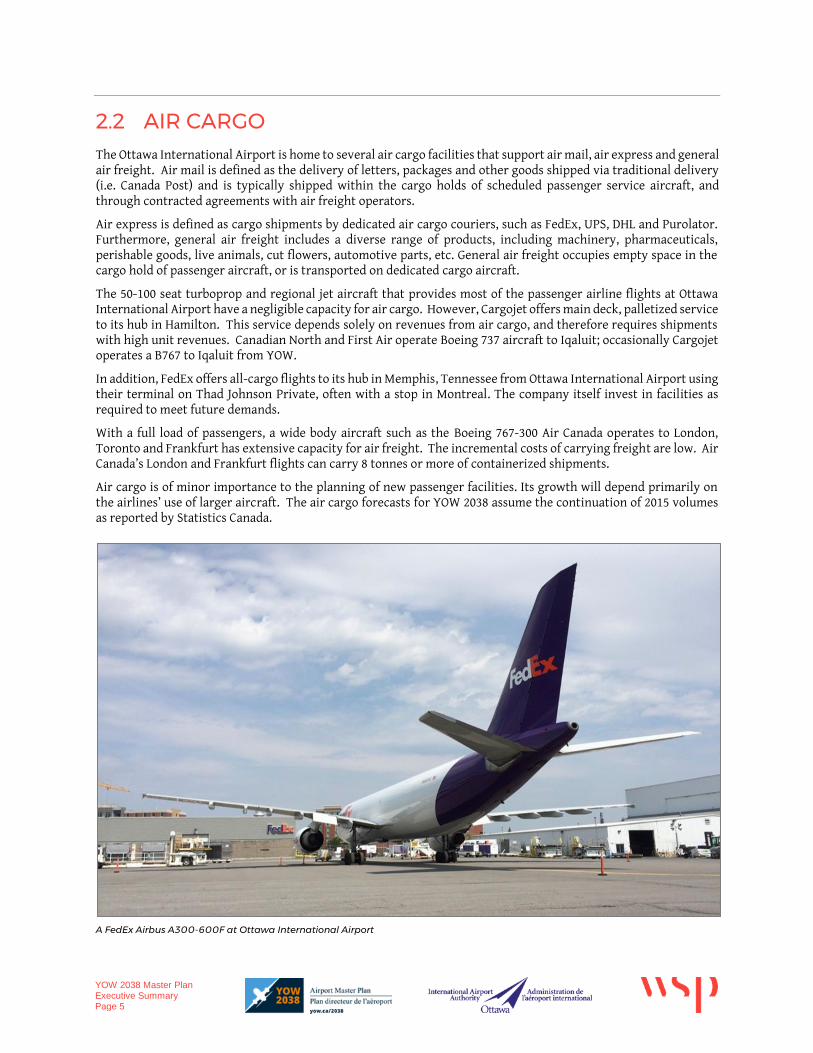
A FedEx Airbus A300-600F at Ottawa International Airport
YOW 2038 Master Plan Executive Summary Page 6
3 AIRPORT INFRASTRUCTURE The Ottawa International Airport is currently certified by Transport Canada under TP312 – Aerodrome Standards and Recommended Practices, 4th Edition; however, the planning and design criteria applied in the Master Plan is consistent with new standards contained within TP312 5th Edition. The critical aircraft for planning purposes in the Master Plan was reconfirmed as the Code E - B747-400 with an Aircraft Group Number (AGN) classification of V (five) for both the runway and taxiway environments at YOW.
3.1 EXISTING FACILITIES
3.1.1 RUNWAYS
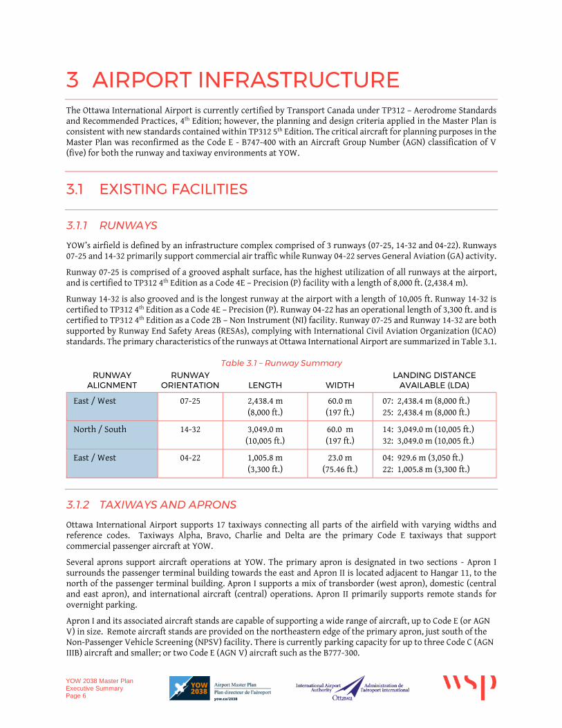
YOW’s airfield is defined by an infrastructure complex comprised of 3 runways (07-25, 14-32 and 04-22). Runways 07-25 and 14-32 primarily support commercial air traffic while Runway 04-22 serves General Aviation (GA) activity.
Runway 07-25 is comprised of a grooved asphalt surface, has the highest utilization of all runways at the airport, and is certified to TP312 4th Edition as a Code 4E – Precision (P) facility with a length of 8,000 ft. (2,438.4 m).
Runway 14-32 is also grooved and is the longest runway at the airport with a length of 10,005 ft. Runway 14-32 is certified to TP312 4th Edition as a Code 4E – Precision (P). Runway 04-22 has an operational length of 3,300 ft. and is certified to TP312 4th Edition as a Code 2B – Non Instrument (NI) facility. Runway 07-25 and Runway 14-32 are both supported by Runway End Safety Areas (RESAs), complying with International Civil Aviation Organization (ICAO) standards. The primary characteristics of the runways at Ottawa International Airport are summarized in Table 3.1.
Table 3.1 – Runway Summary RUNWAY
ALIGNMENT RUNWAY
ORIENTATION LENGTH WIDTH LANDING DISTANCE
AVAILABLE (LDA)
East / West 07-25 2,438.4 m (8,000 ft.)
60.0 m (197 ft.)
07: 2,438.4 m (8,000 ft.) 25: 2,438.4 m (8,000 ft.)
North / South 14-32 3,049.0 m (10,005 ft.)
60.0 m (197 ft.)
14: 3,049.0 m (10,005 ft.) 32: 3,049.0 m (10,005 ft.)
East / West 04-22 1,005.8 m (3,300 ft.)
23.0 m (75.46 ft.)
04: 929.6 m (3,050 ft.) 22: 1,005.8 m (3,300 ft.)
3.1.2 TAXIWAYS AND APRONS
Ottawa International Airport supports 17 taxiways connecting all parts of the airfield with varying widths and reference codes. Taxiways Alpha, Bravo, Charlie and Delta are the primary Code E taxiways that support commercial passenger aircraft at YOW.
Several aprons support aircraft operations at YOW. The primary apron is designated in two sections - Apron I surrounds the passenger terminal building towards the east and Apron II is located adjacent to Hangar 11, to the north of the passenger terminal building. Apron I supports a mix of transborder (west apron), domestic (central and east apron), and international aircraft (central) operations. Apron II primarily supports remote stands for overnight parking.
Apron I and its associated aircraft stands are capable of supporting a wide range of aircraft, up to Code E (or AGN V) in size. Remote aircraft stands are provided on the northeastern edge of the primary apron, just south of the Non-Passenger Vehicle Screening (NPSV) facility. There is currently parking capacity for up to three Code C (AGN IIIB) aircraft and smaller; or two Code E (AGN V) aircraft such as the B777-300.
YOW 2038 Master Plan Executive Summary Page 7
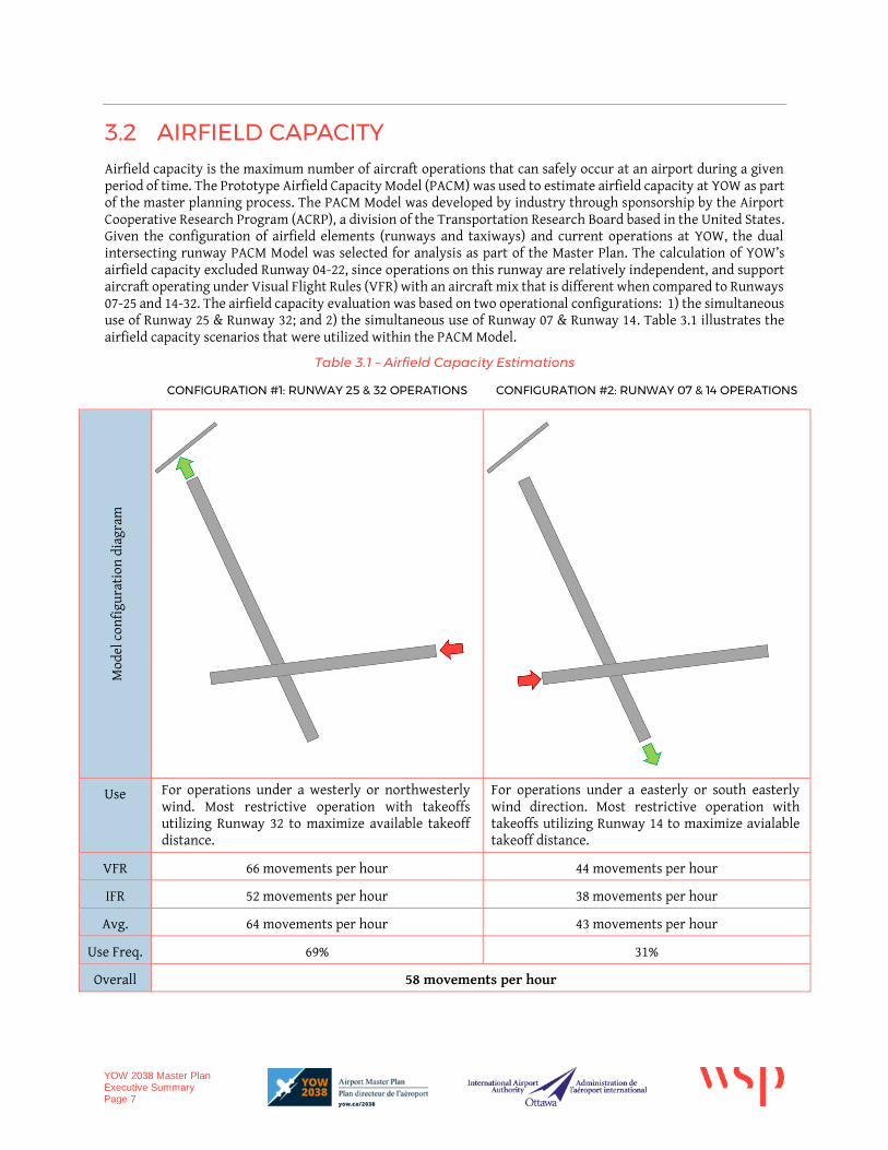
3.2 AIRFIELD CAPACITY Airfield capacity is the maximum number of aircraft operations that can safely occur at an airport during a given period of time. The Prototype Airfield Capacity Model (PACM) was used to estimate airfield capacity at YOW as part of the master planning process. The PACM Model was developed by industry through sponsorship by the Airport Cooperative Research Program (ACRP), a division of the Transportation Research Board based in the United States. Given the configuration of airfield elements (runways and taxiways) and current operations at YOW, the dual intersecting runway PACM Model was selected for analysis as part of the Master Plan. The calculation of YOW’s airfield capacity excluded Runway 04-22, since operations on this runway are relatively independent, and support aircraft operating under Visual Flight Rules (VFR) with an aircraft mix that is different when compared to Runways 07-25 and 14-32. The airfield capacity evaluation was based on two operational configurations: 1) the simultaneous use of Runway 25 & Runway 32; and 2) the simultaneous use of Runway 07 & Runway 14. Table 3.1 illustrates the airfield capacity scenarios that were utilized within the PACM Model.
Table 3.1 – Airfield Capacity Estimations
CONFIGURATION #1: RUNWAY 25 & 32 OPERATIONS CONFIGURATION #2: RUNWAY 07 & 14 OPERATIONS
Mod
el c
onfi
gura
tion
dia
gram
Use For operations under a westerly or northwesterly wind. Most restrictive operation with takeoffs utilizing Runway 32 to maximize available takeoff distance.
For operations under a easterly or south easterly wind direction. Most restrictive operation with takeoffs utilizing Runway 14 to maximize avialable takeoff distance.
VFR 66 movements per hour 44 movements per hour
IFR 52 movements per hour 38 movements per hour
Avg. 64 movements per hour 43 movements per hour
Use Freq. 69% 31%
Overall 58 movements per hour
YOW 2038 Master Plan Executive Summary Page 8
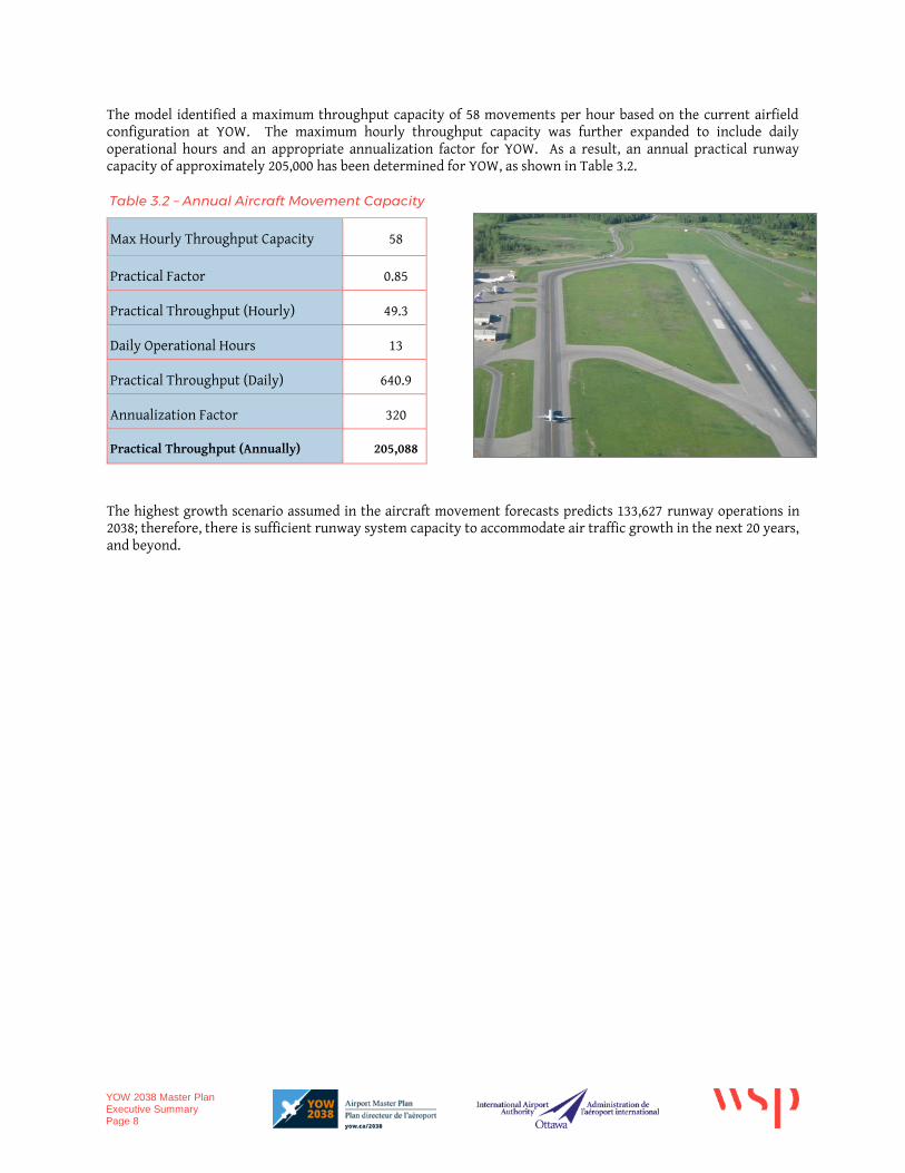
The model identified a maximum throughput capacity of 58 movements per hour based on the current airfield configuration at YOW. The maximum hourly throughput capacity was further expanded to include daily operational hours and an appropriate annualization factor for YOW. As a result, an annual practical runway capacity of approximately 205,000 has been determined for YOW, as shown in Table 3.2.
Table 3.2 – Annual Aircraft Movement Capacity
Max Hourly Throughput Capacity 58
Practical Factor 0.85
Practical Throughput (Hourly) 49.3
Daily Operational Hours 13
Practical Throughput (Daily) 640.9
Annualization Factor 320
Practical Throughput (Annually) 205,088
The highest growth scenario assumed in the aircraft movement forecasts predicts 133,627 runway operations in 2038; therefore, there is sufficient runway system capacity to accommodate air traffic growth in the next 20 years, and beyond.
YOW 2038 Master Plan Executive Summary Page 9
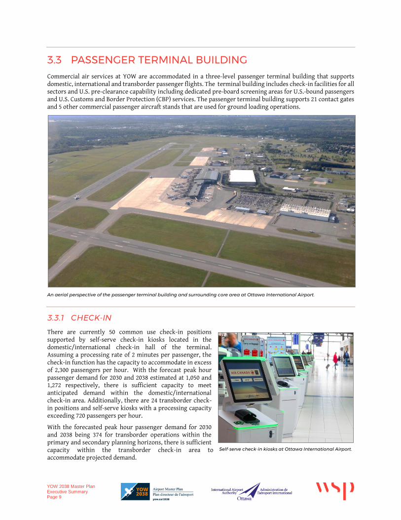
3.3 PASSENGER TERMINAL BUILDING Commercial air services at YOW are accommodated in a three-level passenger terminal building that supports domestic, international and transborder passenger flights. The terminal building includes check-in facilities for all sectors and U.S. pre-clearance capability including dedicated pre-board screening areas for U.S.-bound passengers and U.S. Customs and Border Protection (CBP) services. The passenger terminal building supports 21 contact gates and 5 other commercial passenger aircraft stands that are used for ground loading operations.
An aerial perspective of the passenger terminal building and surrounding core area at Ottawa International Airport.
3.3.1 CHECK-IN
There are currently 50 common use check-in positions supported by self-serve check-in kiosks located in the domestic/international check-in hall of the terminal. Assuming a processing rate of 2 minutes per passenger, the check-in function has the capacity to accommodate in excess of 2,300 passengers per hour. With the forecast peak hour passenger demand for 2030 and 2038 estimated at 1,050 and 1,272 respectively, there is sufficient capacity to meet anticipated demand within the domestic/international check-in area. Additionally, there are 24 transborder check-in positions and self-serve kiosks with a processing capacity exceeding 720 passengers per hour.
With the forecasted peak hour passenger demand for 2030 and 2038 being 374 for transborder operations within the primary and secondary planning horizons, there is sufficient capacity within the transborder check-in area to accommodate projected demand.
Self-serve check-in kiosks at Ottawa International Airport.
YOW 2038 Master Plan Executive Summary Page 10
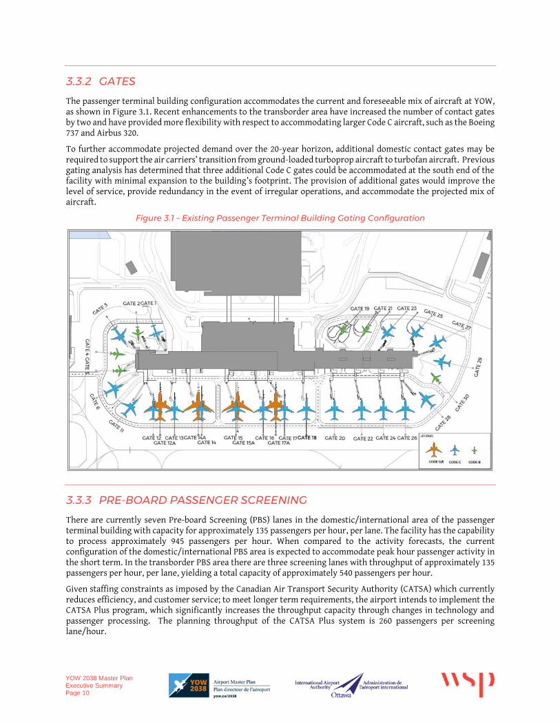
3.3.2 GATES
The passenger terminal building configuration accommodates the current and foreseeable mix of aircraft at YOW, as shown in Figure 3.1. Recent enhancements to the transborder area have increased the number of contact gates by two and have provided more flexibility with respect to accommodating larger Code C aircraft, such as the Boeing 737 and Airbus 320.
To further accommodate projected demand over the 20-year horizon, additional domestic contact gates may be required to support the air carriers’ transition from ground-loaded turboprop aircraft to turbofan aircraft. Previous gating analysis has determined that three additional Code C gates could be accommodated at the south end of the facility with minimal expansion to the building’s footprint. The provision of additional gates would improve the level of service, provide redundancy in the event of irregular operations, and accommodate the projected mix of aircraft.
Figure 3.1 – Existing Passenger Terminal Building Gating Configuration
3.3.3 PRE-BOARD PASSENGER SCREENING
There are currently seven Pre-board Screening (PBS) lanes in the domestic/international area of the passenger terminal building with capacity for approximately 135 passengers per hour, per lane. The facility has the capability to process approximately 945 passengers per hour. When compared to the activity forecasts, the current configuration of the domestic/international PBS area is expected to accommodate peak hour passenger activity in the short term. In the transborder PBS area there are three screening lanes with throughput of approximately 135 passengers per hour, per lane, yielding a total capacity of approximately 540 passengers per hour.
Given staffing constraints as imposed by the Canadian Air Transport Security Authority (CATSA) which currently reduces efficiency, and customer service; to meet longer term requirements, the airport intends to implement the CATSA Plus program, which significantly increases the throughput capacity through changes in technology and passenger processing. The planning throughput of the CATSA Plus system is 260 passengers per screening lane/hour.
YOW 2038 Master Plan Executive Summary Page 11
3.3.4 PRE-BOARD SCREENING REQUIREMENTS
If CATSA Plus were to be implemented in 2018, the domestic/international PBS would require four lanes, which would support forecasted peak demand until 2030. By 2038 an additional 5th PBS lane would be required. Given the forecasted increase in peak hour demand, a proposed phasing of the domestic PBS area includes replacement of the seven existing screening lanes in 2022/2023 with four CATSA Plus screening lanes. By the year 2030 it is expected that the peak hour demand will likely exceed the capacity of the four CATSA Plus domestic/international PBS lanes.
At this time, the domestic PBS screening function should be considered for relocation as a result of the space requirement of CATSA Plus and staffing constraints. Transborder will require two PBS lanes through to 2038.
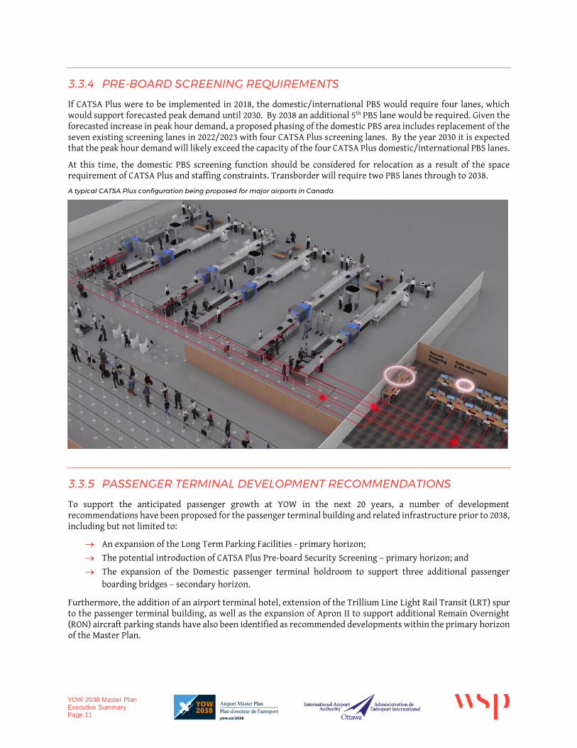
A typical CATSA Plus configuration being proposed for major airports in Canada.
3.3.5 PASSENGER TERMINAL DEVELOPMENT RECOMMENDATIONS
To support the anticipated passenger growth at YOW in the next 20 years, a number of development recommendations have been proposed for the passenger terminal building and related infrastructure prior to 2038, including but not limited to:
An expansion of the Long Term Parking Facilities - primary horizon;
The potential introduction of CATSA Plus Pre-board Security Screening – primary horizon; and
The expansion of the Domestic passenger terminal holdroom to support three additional passenger boarding bridges – secondary horizon.
Furthermore, the addition of an airport terminal hotel, extension of the Trillium Line Light Rail Transit (LRT) spur to the passenger terminal building, as well as the expansion of Apron II to support additional Remain Overnight (RON) aircraft parking stands have also been identified as recommended developments within the primary horizon of the Master Plan.
YOW 2038 Master Plan Executive Summary Page 12
3.4 GROUNDSIDE Airport Parkway is the primary means of road access to the passenger terminal building and YOW’s core development area. The north-south, two-lane undivided arterial road widens to a four-lane divided cross section as it approaches the passenger terminal building. Airport Parkway’s two-lane wide cross section is estimated to have a capacity of approximately 1,800 vehicles per hour. Traffic volumes on Airport Parkway are not expected to increase significantly within the planning horizons of the master plan.
The outbound terminal frontage road supports vehicular traffic from both the arrival and departure curbsides and the Parkade exit. The outbound terminal frontage road has an estimated capacity of approximately 1,800 vehicles per hour.
The construction of the new (LRT) service to YOW may reduce peak hour demand on Airport Parkway and the outbound terminal frontage road, which could result in a reduction in vehicle traffic utilizing the existing access road infrastructure.
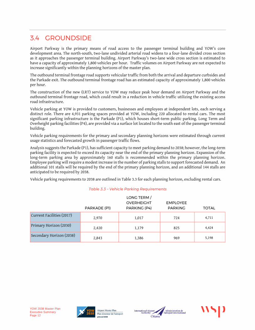
Vehicle parking at YOW is provided to customers, businesses and employees at independent lots, each serving a distinct role. There are 4,931 parking spaces provided at YOW, including 220 allocated to rental cars. The most significant parking infrastructure is the Parkade (P1), which houses short-term public parking. Long Term and Overheight parking facilities (P4), are provided via a surface lot located to the south east of the passenger terminal building.
Vehicle parking requirements for the primary and secondary planning horizons were estimated through current usage statistics and forecasted growth in passenger traffic flows.
Analysis suggests the Parkade (P1), has sufficient capacity to meet parking demand to 2038; however, the long-term parking facility is expected to exceed its capacity near the end of the primary planning horizon. Expansion of the long-term parking area by approximately 160 stalls is recommended within the primary planning horizon. Employee parking will require a modest increase in the number of parking stalls to support forecasted demand. An additional 101 stalls will be required by the end of the primary planning horizon, and an additional 144 stalls are anticipated to be required by 2038.
Vehicle parking requirements to 2038 are outlined in Table 3.3 for each planning horizon, excluding rental cars.
Table 3.3 – Vehicle Parking Requirements
PARKADE (P1)
LONG TERM / OVERHEIGHT PARKING (P4)
EMPLOYEE PARKING TOTAL
Current Facilities (2017) 2,970 1,017 724 4,711
Primary Horizon (2030) 2,420 1,179 825 4,424
Secondary Horizon (2038) 2,843 1,386 969 5,198
YOW 2038 Master Plan Executive Summary Page 13
4 DEVELOPMENT PLAN AND COSTS The Recommended 20-year Development Plan is expected to meet the current and future requirements for airside, passenger terminal and landside facilities and promote safe and efficient operations at YOW.
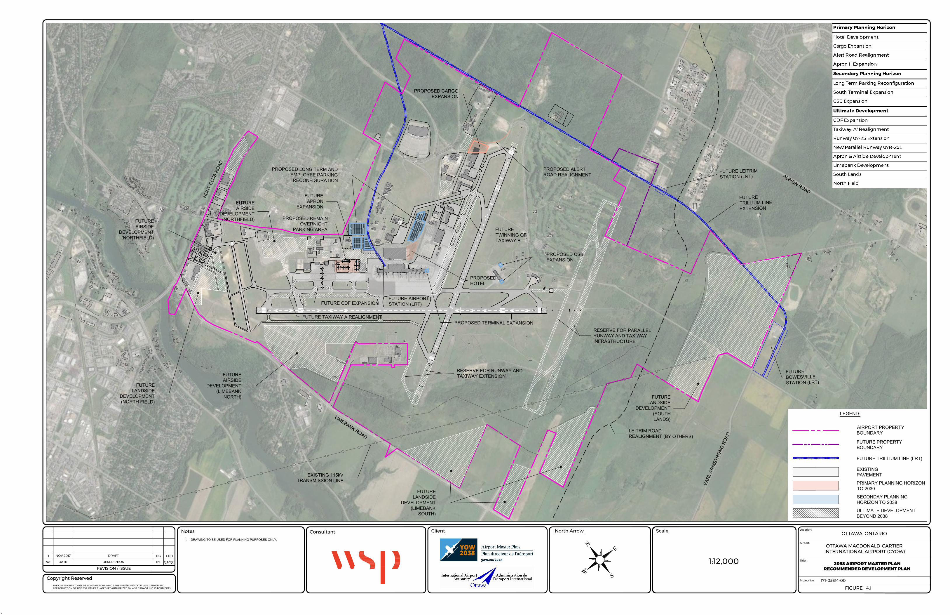
The Ottawa International Airport is a largely mature facility with sufficient airfield capacity to meet the aviation activity expected to occur over the next 20 years. As a result, a requirement to extend or provide new runways or taxiways has not been identified between 2018 and 2038. However, a future parallel Runway 07R-25L and extension to Runway 07-25 have been identified and protected for ultimate or reserve development.
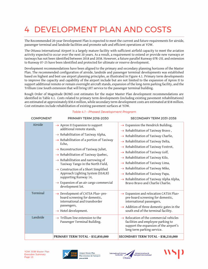
Development recommendations have been aligned to the primary and secondary planning horizons of the Master Plan. The recommended configuration of airside, landside and passenger terminal developments was established based on highest and best use airport planning principles, as illustrated in Figure 4.1. Primary term developments to improve the capacity and capability of the airport include but are not limited to the expansion of Apron II to support additional remote or remain overnight aircraft stands, expansion of the long-term parking facility, and the Trillium Line South extension that will bring LRT service to the passenger terminal building.
Rough Order of Magnitude (ROM) cost estimates for the major Master Plan development recommendations are identified in Table 4.1. Costs related to primary term developments (including existing pavement rehabilitations) are estimated at approximately $30.4 million, while secondary term development costs are estimated at $38 million. Cost estimates include rehabilitation of existing pavement surfaces at YOW.
Table 4.1 – Phased Development Program
COMPONENT PRIMARY TERM 2018-2030 SECONDARY TERM 2031-2038
Airside Apron II Expansion to support additional remote stands,
Rehabilitation of Taxiway Alpha,
Rehabilitation of a portion of Taxiway Echo,
Reconstruction of Taxiway Juliet,
Rehabilitation of Taxiway Quebec,
Rehabilitation and narrowing of Taxiway Tango in the North Field,
Construction of a Short Simplified Approach Lighting System (SSALR) supporting Runway 14,
Expansion of an air cargo commercial development lot.
Expansion the Hendrick Building,
Rehabilitation of Taxiway Bravo ,
Rehabilitation of Taxiway Charlie,
Rehabilitation of Taxiway Delta,
Rehabilitation of Taxiway Foxtrot,
Rehabilitation of Taxiway Golf,
Rehabilitation of Taxiway Kilo,
Rehabilitation of Taxiway Lima,
Rehabilitation of Taxiway Mike,
Rehabilitation of Taxiway Papa,
Rehabilitation of Taxiway Alpha Alpha, Bravo Bravo and Charlie Charlie.
Terminal Development of CATSA Plus+ pre-board screening for domestic, international and transborder passengers,
Hotel development.
Expansion and relocation CATSA Plus+ pre-board screening for domestic, international passengers,
Addition of three domestic gates in the south end of the terminal facility.
Landside Trillium line extension to the Passenger Terminal Building.
Relocation of the commercial vehicles facilities and employee parking to support the expansion of the airport’s long term parking service.
PRIMARY TERM TOTAL - $32,850,000 SECONDARY TERM TOTAL - $38,210,000
F
U
T
U
R
E
T
A
X
I
W
A
Y
E
X
T
E
N
S
I
O
N
476
30
6
B 2
42
44
{
{
XX
XX
X
XXX
XX
X
XX
XXX
XXX
XXXX
X
X X
X
X
AT
B
T-5
0
3.000
PRO
POSE
D 2
-STO
REY
AUTO
MO
BILE
DEA
LERS
HIP
OTT
O'S
BMW
4242424242
42
32323232323216
21
11
23
27
31
36
43
53
42
26
32
18
A321-200 SHARKLET
A321-200 SHARKLET
A321-200 SHARKLET
A321-200 SHARKLET
A321-200 SHARKLET
A321-200 SHARKLET
A321-200 SHARKLET
A321-200 SHARKLET
A321-200 SHARKLET
A321-200 SHARKLET
AG
N IIIA
/B
AG
N IIIA
/B
FUT.
NPSV
NPSV ACCESS
TAXILANE AGN II
TA
XIL
AN
E A
GN
IIIA
/B
GSE
FUT.
NPSV
FUTURELANDSIDE
DEVELOPMENT(NORTH FIELD)
FUTURELANDSIDE
DEVELOPMENT(LIMEBANK
SOUTH)
FUTURELANDSIDE
DEVELOPMENT(SOUTHLANDS)
FUTUREAIRSIDE
DEVELOPMENT(LIMEBANK
NORTH)
PROPOSED CARGOEXPANSION
PROPOSEDHOTEL
FUTUREAIRSIDE
DEVELOPMENT(NORTHFIELD)
FUTURE CDF EXPANSION
FUTURE TAXIWAY A REALIGNMENT
PROPOSED LONG TERM ANDEMPLOYEE PARKINGRECONFIGURATION
PROPOSED REMAINOVERNIGHT
PARKING AREA
PROPOSED CSBEXPANSION
FUTUREAPRON
EXPANSIONFUTUREAIRSIDE
DEVELOPMENT(NORTHFIELD)
PROPOSED ALERTROAD REALIGNMENT
PROPOSED TERMINAL EXPANSION
FUTURETWINNING OFTAXIWAY B
RESERVE FOR RUNWAY ANDTAXIWAY EXTENSION
RESERVE FOR PARALLELRUNWAY AND TAXIWAYINFRASTRUCTURE
LEITRIM ROADREALIGNMENT (BY OTHERS)
FUTUREBOWESVILLESTATION (LRT)
EARL
ARM
STRO
NG R
OAD
ALBION ROAD
HUNT
CLU
B RO
AD
FUTURETRILLIUM LINEEXTENSION
LIMEBANK ROAD
EXISTING 115kVTRANSMISSION LINE
FUTURE LEITRIMSTATION (LRT)
FUTURE AIRPORTSTATION (LRT)
EXISTINGPAVEMENT
LEGEND:
PRIMARY PLANNING HORIZONTO 2030
SECONDAY PLANNINGHORIZON TO 2038
ULTIMATE DEVELOPMENTBEYOND 2038
FUTURE TRILLIUM LINE (LRT)
FUTURE PROPERTYBOUNDARY
AIRPORT PROPERTYBOUNDARY
THE COPYRIGHTS TO ALL DESIGNS AND DRAWINGS ARE THE PROPERTY OF WSP CANADA INC.
REPRODUCTION OR USE FOR OTHER THAN THAT AUTHORIZED BY WSP CANADA INC. IS FORBIDDEN.
Project No.
Airport:
171-05314-00
Title:
Location:
Client Scale
OTTAWA MACDONALD-CARTIER
INTERNATIONAL AIRPORT (CYOW)
OTTAWA, ONTARIO
FIGURE
North Arrow
Copyright Reserved
REVISION / ISSUE
DATE DESCRIPTIONNo. BY QA/QC
NotesConsultant
4
2018 AIRPORT MASTER PLAN
EXISTING CONDITIONS SITE PLAN - NORTH EAST
0 10/05/2017 DRAFT EDHRAM1. DRAWING TO BE USED FOR PLANNING PURPOSES ONLY. GRID NORTH
SCALE BASED ON SHEET SIZE 22" X 34"
AIRPORT PROPERTY BOUNDARYBUILDINGSAIRFIELD PAVEMENT
LEGEND
FUTURE O-TRAIN TRACKS
1. DRAWING TO BE USED FOR PLANNING PURPOSES ONLY.
N
SW
E
1:12,000
4.1
1 DRAFT DG EDH
NOV 2017
2038 AIRPORT MASTER PLAN
RECOMMENDED DEVELOPMENT PLAN
YOW 2038 Master Plan Executive Summary Page 15
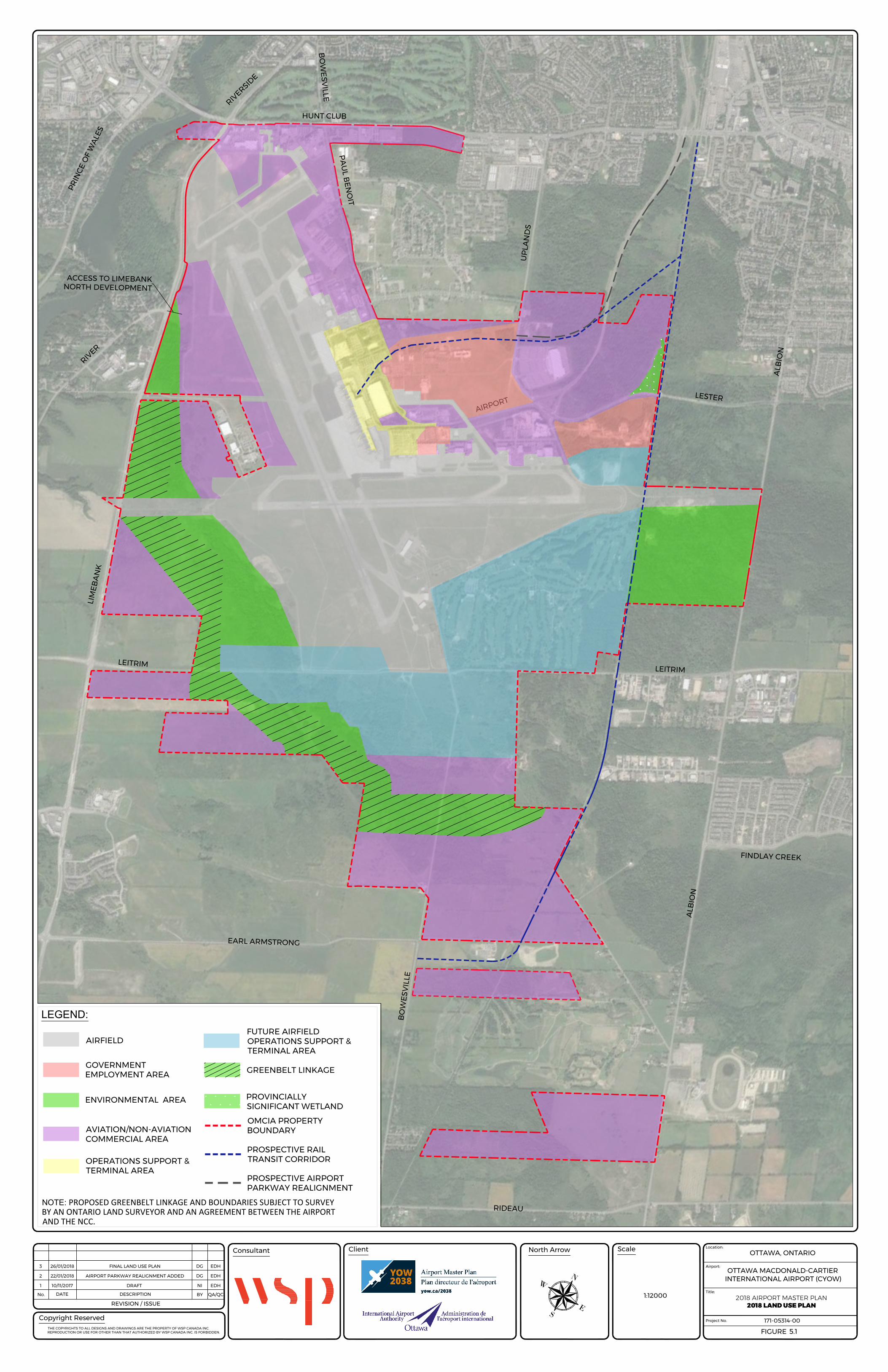
5 LAND USE PLAN The proposed YOW 2038 Land Use Plan was developed to replace the Transport Canada-approved 2008 version. Updates incorporate consideration of potential uses and development within the 20-year planning horizon.
5.1 LAND USE DESIGNATIONS The Land Use Plan is made up of the following land use designations:
AIRFIELD
Areas designated Airfield are for current airport essential operating components as listed. Also within this category land is used for storm water management and glycol treatment.
The runway system
Taxiways and taxi lanes
The de-icing pads
Aircraft fuel compound
Overnight aircraft parking areas
Daytime cargo aircraft parking areas
Airline and airport support functions including aircraft fuelling areas and
Groundside and Airside Maintenance & Airport Emergency Response Service (AERS)
Aeronautical protection areas within the airport boundary
OPERATIONS SUPPORT AND TERMINAL AREA
The ‘Operations Support & Terminal Area’ designation is assigned to land currently used and proposed to be used for airport passenger operations, passenger accommodation to include hotels and aviation operations support. This area includes the passenger terminal building, navigation and airport administrative facilities and spaces curb front along the building, terminal rail and surface access, road systems, parking facilities and ground and airside maintenance & emergency response.
FUTURE AIRFIELD OPERATIONS SUPPORT AND TERMINAL AREA
This category defines land to be used for future airport essential operating components such as runway reserve and:
The runway system;
Taxiways and taxilanes;
The de-icing pads;
Navigation Aids;
Terminal Space;
Aircraft fuel compound;
Overnight aircraft parking areas;
Daytime cargo aircraft parking areas;
Airline and airport support functions including aircraft fuelling areas;
Groundside and Airside Maintenance & Emergency Response; and
Aeronautical protection areas within the airport boundary.
The future airfield operations support and terminal area protects land for a possible future parallel Runway 07R 25L, which is currently protected by the existing Airport Zoning Regulations (AZR). This
YOW 2038 Master Plan Executive Summary Page 16
Runway is not projected to be required within the 20-year planning horizon of this Master Plan but will be examined further in the next Master Plan.
The City of Ottawa is currently planning to build and bring LRT services into operation to a proposed Bowesville Station south of the airport, off Earl Armstrong Road. The proposal conflicts with the existing Airport Zoning Regulations as it related to prospective Runway 07R 27L. The Authority will work with the City of Ottawa to identify possible avenues to address the conflict.
AVIATION/NON-AVIATION COMMERCIAL AREA
On land designated ‘Aviation/Non-Aviation Commercial Area’ will be permitted aviation and non-aviation related commercial, industrial warehousing and employment uses. The intent of the designation is to provide flexibility of development options on the designated lands.
This designation allows a wide mix of land uses that are both akin to those traditionally associated with airports (such as car rentals, airside cargo, flight schools) and to uses typically characteristic of business parks, terminal rail facilities and structures and community oriented commercial areas (such as offices, light manufacturing, restaurants, research and development, laboratories, personal service establishments, athletic and indoor recreational centres, retail establishments). Priority will be given to aviation related uses. Employment uses will include public services such as paramedic and police installations as well as public transit stations and rail transit. Land within this category is also used for storm water management and to accommodate fuelling facilities.
GOVERNMENT EMPLOYMENT AREA
The Government Employment Area land use designation applies to land parcels currently occupied by federal government departments and government agencies such as the National Research Council, Department of National Defence, Canada Aircraft Services Hangar, and the Transportation Safety Board laboratories and offices.
PROSPECTIVE RAIL TRANSIT CORRIDOR
Potential Future Rapid Transit Corridor is illustrated in Figure 5.1 and reserves land for a future light rail link to the airport.
ENVIRONMENTAL AREA
The ‘Environmental Area’ designation contains those lands which, through studies conducted, are known to be ecologically important or are being reserved for environmental purposes. This designation is specifically the means through which compliance with provincial natural heritage and federal wildlife protection legislation (such as the Species at Risk Act) will be achieved. There will be no development of land identified as being environmentally significant.
To protect areas of ecological importance, development proposed within 30 metres should be supported by Environmental Impact Statements (EISs) that identify appropriate mitigation measures for implementation.
ENVIRONMENTAL AREA (GREENBELT LINKAGE)
The Greenbelt Linkage is part of land reserved for environmental purposes which will form part of a potential future link between the Greenbelt lands to the west of the airport and the Leitrim Wetland. The Greenbelt Linkage and boundaries are subject to boundaries being established by an Ontario Land Surveyor and an agreement between the airport and the National Capital Commission (NCC).
YOW 2038 Master Plan Executive Summary Page 17
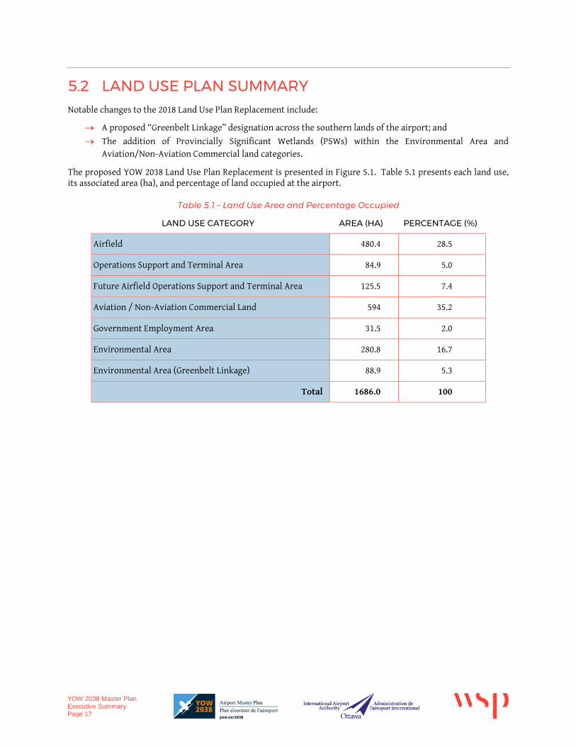
5.2 LAND USE PLAN SUMMARY Notable changes to the 2018 Land Use Plan Replacement include:
A proposed “Greenbelt Linkage” designation across the southern lands of the airport; and
The addition of Provincially Significant Wetlands (PSWs) within the Environmental Area and Aviation/Non-Aviation Commercial land categories.
The proposed YOW 2038 Land Use Plan Replacement is presented in Figure 5.1. Table 5.1 presents each land use, its associated area (ha), and percentage of land occupied at the airport.
Table 5.1 – Land Use Area and Percentage Occupied
LAND USE CATEGORY AREA (HA) PERCENTAGE (%)
Airfield 480.4 28.5
Operations Support and Terminal Area 84.9 5.0
Future Airfield Operations Support and Terminal Area 125.5 7.4
Aviation / Non-Aviation Commercial Land 594 35.2
Government Employment Area 31.5 2.0
Environmental Area 280.8 16.7
Environmental Area (Greenbelt Linkage) 88.9 5.3
Total 1686.0 100
HUNT CLUB
BO
WE
SV
ILLE
R
I
V
E
R
S
I
D
E
UP
LA
ND
S
PA
UL B
EN
OIT
LIM
EB
AN
K
LEITRIM
R
I
V
E
R
EARL ARMSTRONG
A
IR
P
O
R
TB
OW
ES
VILLE
RIDEAU
ALB
IO
N
P
R
IN
C
E
O
F
W
A
L
E
S
LEITRIM
FINDLAY CREEK
ALB
IO
N
LES
TE
R
ACCESS TO LIMEBANK
NORTH DEVELOPMENT
PROSPECTIVE RAIL
TRANSIT CORRIDOR
AIRFIELD
LEGEND:
ENVIRONMENTAL AREA
OMCIA PROPERTY
BOUNDARYAVIATION/NON-AVIATION
COMMERCIAL AREA
GOVERNMENT
EMPLOYMENT AREA
GREENBELT LINKAGE
FUTURE AIRFIELD
OPERATIONS SUPPORT &
TERMINAL AREA
OPERATIONS SUPPORT &
TERMINAL AREA
PROVINCIALLY
SIGNIFICANT WETLAND
PROSPECTIVE AIRPORT
PARKWAY REALIGNMENT
NOTE: PROPOSED GREENBELT LINKAGE AND BOUNDARIES SUBJECT TO SURVEYBY AN ONTARIO LAND SURVEYOR AND AN AGREEMENT BETWEEN THE AIRPORTAND THE NCC.
THE COPYRIGHTS TO ALL DESIGNS AND DRAWINGS ARE THE PROPERTY OF WSP CANADA INC.
REPRODUCTION OR USE FOR OTHER THAN THAT AUTHORIZED BY WSP CANADA INC. IS FORBIDDEN.
Project No.
Airport:
171-05314-00
Title:
Location:
Client Scale
OTTAWA MACDONALD-CARTIER
INTERNATIONAL AIRPORT (CYOW)
OTTAWA, ONTARIO
FIGURE
North Arrow
Copyright Reserved
REVISION / ISSUE
DATE DESCRIPTIONNo. BY QA/QC
Consultant
2018 AIRPORT MASTER PLAN
EXISTING CONDITIONS SITE PLAN - NORTH EAST
2018 AIRPORT MASTER PLAN
2018 LAND USE PLAN
1:12000
1 DRAFT NI EDH10/11/2017
5.1
N
SE
W2 AIRPORT PARKWAY REALIGNMENT ADDED DG EDH22/01/2018
3 FINAL LAND USE PLAN DG EDH26/01/2018