Embed Size (px)
Citation preview
THESE TERMS GOVERN YOUR USE OF THIS DOCUMENT
Your use of this Ontario Geological Survey document (the “Content”) is governed by the terms set out on this page (“Terms of Use”). By downloading this Content, you (the
“User”) have accepted, and have agreed to be bound by, the Terms of Use.
Content: This Content is offered by the Province of Ontario’s Ministry of Northern Development and Mines (MNDM) as a public service, on an “as-is” basis. Recommendations and statements of opinion expressed in the Content are those of the author or authors and are not to be construed as statement of government policy. You are solely responsible for your use of the Content. You should not rely on the Content for legal advice nor as authoritative in your particular circumstances. Users should verify the accuracy and applicability of any Content before acting on it. MNDM does not guarantee, or make any warranty express or implied, that the Content is current, accurate, complete or reliable. MNDM is not responsible for any damage however caused, which results, directly or indirectly, from your use of the Content. MNDM assumes no legal liability or responsibility for the Content whatsoever. Links to Other Web Sites: This Content may contain links, to Web sites that are not operated by MNDM. Linked Web sites may not be available in French. MNDM neither endorses nor assumes any responsibility for the safety, accuracy or availability of linked Web sites or the information contained on them. The linked Web sites, their operation and content are the responsibility of the person or entity for which they were created or maintained (the “Owner”). Both your use of a linked Web site, and your right to use or reproduce information or materials from a linked Web site, are subject to the terms of use governing that particular Web site. Any comments or inquiries regarding a linked Web site must be directed to its Owner. Copyright: Canadian and international intellectual property laws protect the Content. Unless otherwise indicated, copyright is held by the Queen’s Printer for Ontario. It is recommended that reference to the Content be made in the following form: <Author’s last name>, <Initials> <year of publication>. <Content title>; Ontario Geological Survey, <Content publication series and number>, <total number of pages>p. Use and Reproduction of Content: The Content may be used and reproduced only in accordance with applicable intellectual property laws. Non-commercial use of unsubstantial excerpts of the Content is permitted provided that appropriate credit is given and Crown copyright is acknowledged. Any substantial reproduction of the Content or any commercial use of all or part of the Content is prohibited without the prior written permission of MNDM. Substantial reproduction includes the reproduction of any illustration or figure, such as, but not limited to graphs, charts and maps. Commercial use includes commercial distribution of the Content, the reproduction of multiple copies of the Content for any purpose whether or not commercial, use of the Content in commercial publications, and the creation of value-added products using the Content. Contact:
FOR FURTHER INFORMATION ON PLEASE CONTACT: BY TELEPHONE: BY E-MAIL:
The Reproduction of Content
MNDM Publication Services
Local: (705) 670-5691 Toll Free: 1-888-415-9845, ext.
5691 (inside Canada, United States)
The Purchase of MNDM Publications
MNDM Publication Sales
Local: (705) 670-5691 Toll Free: 1-888-415-9845, ext.
5691 (inside Canada, United States)
Crown Copyright Queen’s Printer Local: (416) 326-2678 Toll Free: 1-800-668-9938
(inside Canada, United States)
LES CONDITIONS CI-DESSOUS RÉGISSENT L'UTILISATION DU PRÉSENT DOCUMENT.
Votre utilisation de ce document de la Commission géologique de l'Ontario (le « contenu ») est régie par les conditions décrites sur cette page (« conditions d'utilisation »). En
téléchargeant ce contenu, vous (l'« utilisateur ») signifiez que vous avez accepté d'être lié par les présentes conditions d'utilisation.
Contenu : Ce contenu est offert en l'état comme service public par le ministère du Développement du Nord et des Mines (MDNM) de la province de l'Ontario. Les recommandations et les opinions exprimées dans le contenu sont celles de l'auteur ou des auteurs et ne doivent pas être interprétées comme des énoncés officiels de politique gouvernementale. Vous êtes entièrement responsable de l'utilisation que vous en faites. Le contenu ne constitue pas une source fiable de conseils juridiques et ne peut en aucun cas faire autorité dans votre situation particulière. Les utilisateurs sont tenus de vérifier l'exactitude et l'applicabilité de tout contenu avant de l'utiliser. Le MDNM n'offre aucune garantie expresse ou implicite relativement à la mise à jour, à l'exactitude, à l'intégralité ou à la fiabilité du contenu. Le MDNM ne peut être tenu responsable de tout dommage, quelle qu'en soit la cause, résultant directement ou indirectement de l'utilisation du contenu. Le MDNM n'assume aucune responsabilité légale de quelque nature que ce soit en ce qui a trait au contenu. Liens vers d'autres sites Web : Ce contenu peut comporter des liens vers des sites Web qui ne sont pas exploités par le MDNM. Certains de ces sites pourraient ne pas être offerts en français. Le MDNM se dégage de toute responsabilité quant à la sûreté, à l'exactitude ou à la disponibilité des sites Web ainsi reliés ou à l'information qu'ils contiennent. La responsabilité des sites Web ainsi reliés, de leur exploitation et de leur contenu incombe à la personne ou à l'entité pour lesquelles ils ont été créés ou sont entretenus (le « propriétaire »). Votre utilisation de ces sites Web ainsi que votre droit d'utiliser ou de reproduire leur contenu sont assujettis aux conditions d'utilisation propres à chacun de ces sites. Tout commentaire ou toute question concernant l'un de ces sites doivent être adressés au propriétaire du site. Droits d'auteur : Le contenu est protégé par les lois canadiennes et internationales sur la propriété intellectuelle. Sauf indication contraire, les droits d'auteurs appartiennent à l'Imprimeur de la Reine pour l'Ontario. Nous recommandons de faire paraître ainsi toute référence au contenu : nom de famille de l'auteur, initiales, année de publication, titre du document, Commission géologique de l'Ontario, série et numéro de publication, nombre de pages. Utilisation et reproduction du contenu : Le contenu ne peut être utilisé et reproduit qu'en conformité avec les lois sur la propriété intellectuelle applicables. L'utilisation de courts extraits du contenu à des fins non commerciales est autorisé, à condition de faire une mention de source appropriée reconnaissant les droits d'auteurs de la Couronne. Toute reproduction importante du contenu ou toute utilisation, en tout ou en partie, du contenu à des fins commerciales est interdite sans l'autorisation écrite préalable du MDNM. Une reproduction jugée importante comprend la reproduction de toute illustration ou figure comme les graphiques, les diagrammes, les cartes, etc. L'utilisation commerciale comprend la distribution du contenu à des fins commerciales, la reproduction de copies multiples du contenu à des fins commerciales ou non, l'utilisation du contenu dans des publications commerciales et la création de produits à valeur ajoutée à l'aide du contenu. Renseignements :
POUR PLUS DE RENSEIGNEMENTS SUR VEUILLEZ VOUS
ADRESSER À : PAR TÉLÉPHONE : PAR COURRIEL :
la reproduction du contenu
Services de publication du MDNM
Local : (705) 670-5691 Numéro sans frais : 1 888 415-9845,
poste 5691 (au Canada et aux États-Unis)
l'achat des publications du MDNM
Vente de publications du MDNM
Local : (705) 670-5691 Numéro sans frais : 1 888 415-9845,
poste 5691 (au Canada et aux États-Unis)
les droits d'auteurs de la Couronne
Imprimeur de la Reine
Local : 416 326-2678 Numéro sans frais : 1 800 668-9938
(au Canada et aux États-Unis)
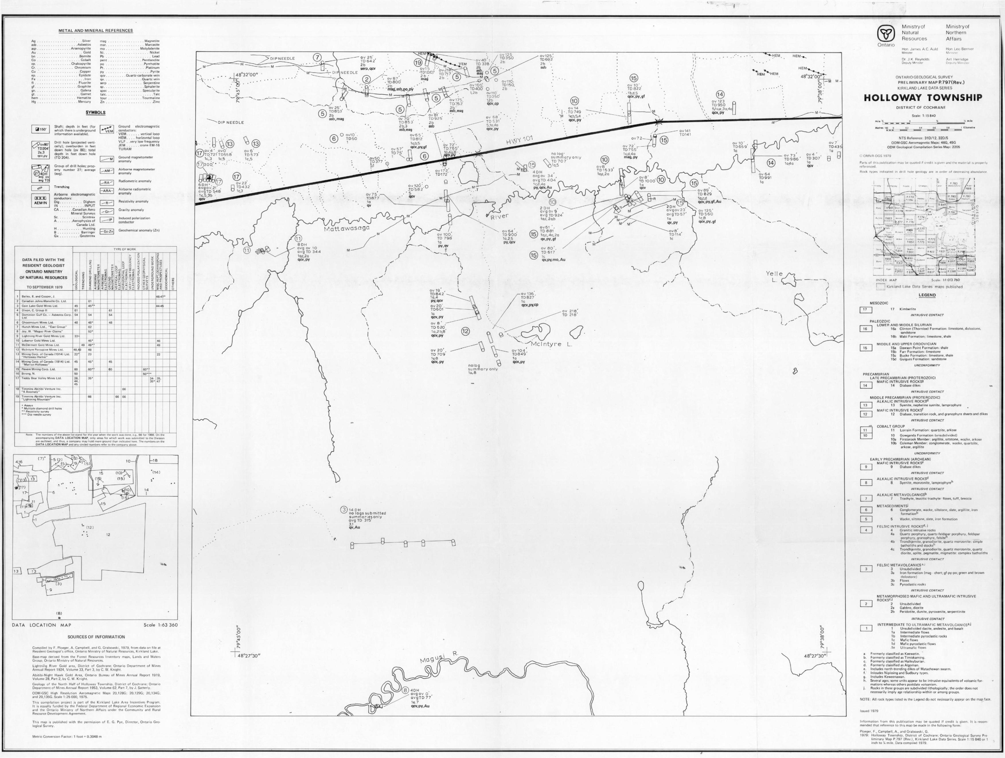
METAL AND MINERAL REFERENCES
Ag . . . . . . . . . . - . . . . . . . . . Silverasb . . . . . . . . . . . . . . . . . .Asbestosasp . . . . . . . . . . . . . . .ArsenopyriteAu . . . . . . . . . . . . . . . . . . . . Goldbn . . . . . . . . . . . . . . . . . . .BorniteCo . . . . . . . . . . . . - . . . . . . Cobaltcp, . . . . . . . . . . . . . . . ChalcopyriteCr. . . . . , . . . . . , . . . . . ChromiumCu .'. . . . . . . . . . . . . . . . . .Copperep. . . . . . . . . . . . . . . . . . . EpidoteFe . . . . . . . . . . . . . . . . . . . . .Ironfi . . . . . . . . . . . . . . . . . . . Fluoritegf . . . . . . . . . . . . . . . . . . .Graphitegn. . . . . . . . . . . . . . . . . . . . Galenagt. . . . . . . . . . , . . . . . . . . . Garnethem . . . . . . . . . . . . . . . . HematiteHg . . . . . . . . . , , . . , , . . , Mercury
mag . . . . . . . . . . . . . . . . Magnetitemar. . . . . . . . . . . . . . . . . Marcasitemo . . . . . . . . . . . . . . . MolybdeniteNi. . . . . . . . . . . . . . . . . . . . NickelPb . . . . . . . . . . . . . . . . . . . . Leadpent . . . . . . . . . . . . . . . Pentlanditepo . . . . . . . . . . . . . . . . .PyrrhotitePt. . . . . . . . . . . . . . . . . . .Platinumpy . . . . . . . . . . . . . . . . . . . .Pyriteqcv . . . . . . . . . Quartz-carbonate veinqv. . . . . . . . . . . . . . . . .Quartz veinserp . . . . , . . . . . . . . . . Serpentinesp. . . . . . . . . . . . . . . . . .Sphaleritespec . . . . . . . . . . . . . . . Specularitetalc. . , . . . . . . . . . . . . . . . . . .Talctour . . . . . . . . . . . . . . .TourmalineZn . . . . . . . . . . . . . . . . , . . . -Zinc
Ontario
SYMBOLS
avg ov avg TD
AEM-IN
Shaft; depth in feet (forwhich there is underground information available).
Drill hole (projected verti cally); overburden in feet dawn hole (ov 80); total depth in feet down hole (TD 204).
Group of drill holes; prop erty number 27; average(avg).
Trenching
Airborne electromagneticconductors:Dig . . . . . . . . . . DighemIN . . . . . . . . . . .INPUTCA . , . . . .Canadian Aero
Mineral Surveys Se. . . . . . . . . . ScintrexA . . . . . . .Aerophysics of
Canada Ltd. H . . . . . . . . . . . HuntingB . . . . . . . . . . BarringerGx . . . . . . . . .Geoterrex
Ground electromagneticconductors:VEM. . . . . . vertical loopHEM. . . . horizontal loopVLF . .very low frequency JEM . . . . . . crone FM-16TURAM
Ground magnetometeranomaly
Airborne magnetometer anomaly
Radiometric anomaly
Airborne radiometric anomaly
Induced polarization conductor
- Gc-Zn Geochemical anomaly (Zn)
Resistivity anomaly
Gravity anomaly
DATA FILED WITH THE
RESIDENT GEOLOGIST
ONTARIO MINISTRY
OF NATURAL RESOURCES
TO SEPTEMBER 1979
i2
3
4
5
6
7
8
9
10
11
12
13
14
15
16
17
18
19
Bailey, E. and Cooper, J.
Canadian Johns-Manville Co. Ltd.
Coin Lake Gold Mines Ltd.
Dixon, C. Group II
Dominion Gulf Co. Asbestos Corp. Ltd.
Ghostmount Mines Ltd.
Hunch Mines Ltd., "East Group"
Joy, W. "Magusi River Claims"
Lightning River Gold Mines Ltd.
Lobanor Gold Mines Ltd.
McDermott Gold Mines Ltd.
Mcintyre Porcupine Mines Lid.
Mining Corp. of Canada (1914) Ltd."Holloway -Harker"
Mining Corp. of Canada (1914) Ltd. "Marnot-Holloway"
Revere Mining Corp. Ltd.
Strong, N.
Teddy Bear Valley Mines Ltd.
Timmins Abitibi Venture Inc. "4 Anomaly"
Timmins Abitibi Venture Inc."Lightning Mountain"
-t Assays * Multiple diamond drill holes** Resistivity survey *" Dip needle survey
TYPE OF WORK
t
GEOLOGICAL
45
61
54
48
33*
48.422*
45
GO
50
26, 44, 45
TRENCHING
49
J
DIAMOND DRILLING
6145*
54
48"
AIRBORNE
MAGNETOMETER
n
6252'
46*
49 . rf
48
23
4S+
60'
35*
66
0-
AIRBORNE
ELECTROMAG,
GROUND
MAGNETOMETER
61
54
48
45
BO
VERTICAL LOOP ELECTROMAG,
66
HORIZONTAL LOOP
ELECTROMAG.
VERY LOW FREQUENCY
ELECTROMAG.
66
66
INDUCED POLARIZATIONOTHER GEOPHYSICAL
SURVEYS
60'
50'
UNDERGROUNDWORK
*
34-3B+
MISC. REPT, CORRESPOND
AN D PROSPECTUSES
GEOCHEMICAL
46-4T+
44-4^
46
49
22
35,47
OTHERS
Note; The numbers of the above list stand for the year when the work was clone, e. y., 66 for 1966. On the accompanying DATA LOCATION MAP, only areas for which work was submitted to the Division are outlined, and thus, a company may hold more ground than indicated here. The numbers on the DATA LOCATION MAP and any circled numbers refer to the company above
DATA LOCATION MAP Scale 1:63 360
SOURCES OF INFORMATION
Compiled by F. Ploeger, A. Campbell, and G. Grabowski, 1979, from data on file at Resident Geologist's office, Ontario Ministry of Natural Resources, Kirkland Lake.
Base-map derived from the Forest Resources Inventory maps. Lands and Waters Group, Ontario Ministry of Natural Resources.
Lightning River Gold area. District of Cochrane; Ontario Department of Mines Annual Report 1924, Volume 33, Part 3, by C. W. Kmqhl.
Abitibi-Night Hawk Gold Area, Ontario Bureau of Mines Annual Report 1919, Volume 28, Part 2, by C. W. Knight.
Geoloyy of the North Half of Holloway Township, District of Cochrane; Ontario Department of Mines Annual Report 1953, Volume 62, Part 7, by J. Satterly.
ODM-GSC High Resolution Aeromagnetic Maps 20,128G; 20,129G; 20,134G; and 20,135G. Scale 1:25000, 1975.
This compilation project is part of the Kirkland Lake Area Incentives Program. It is equally funded by the Federal Department of Regional Economic Expansion and the Ontario Ministry of Northern Affairs under the Community and Rural Resource Development Agreement.
This map is published with the permission of E. G. Pye, Director, Ontario Geo logical Survey.
Metric Conversion Factor: 1 foot s 0.3048 m
ov 125TD3502b
ov 25 TD 64 2 2b serp, qcv
DIPNEEDLE
M
-OV40TD 338
ov 67 TD80O 2 b miag,asb,po,py
OV110- TD15O. 2b
ov 10' , TD 822
b,d 5 qcv,py,gf
ov175 TD762' 2 b/'
asb, may
ov 123 TD 950
ov 25' , TD853 2b asb.mag
ov 14 TD 749 1c,b,5,4 qcv, py
OV81TD9252b asb
ov 70' , . TD853 2b,3 asb.mag
ov 6 5 ', TD812 1o,b,5 qcv,py,gf
DP NEEDLE5,1a4a qcv,py OV141
TD141O ovlO'
TD50ov 10'TD6591Q
qv 72 f O 7 6 5'I6.4a'8-
ov 72 - TD755'1 c,d,4a mag, py
OV4 ovO ov 6 TD5731c.5
17,1c,3 1c,5
17)300.'-
Ov4 TD 307 1a qcv
ov 73 TD986Ia4a
summary only O\ TD 707'
ov8 TD1533ov172
TD1724DH avgov 34avgTD 404 1 e,d ,4a py,qcv,Au
OV22TD432 1c,3
6DH ovgov 21ovgTD 5481c,5,3b "- qcv
ov 120.TD5825
ov89 , TD 629 1d,c,d qcv,py,gf,Au
ov/5TD877
2DHa v g ov 2 3avgTD 57 1aqv.py
ov T25 TD 560 1c,8 qcv,py,gf
ov6l , TD 8811a,c,4a,2aqv,py,gt
ov 64 TD 900 1a,25 py,qcv
8DH avg ov avg TD1a,c 2 a qcv,py
ov 136 , TDS27 1o qcv,py,cp
Mcl nty reov 1O4 TD849 la qcvf py
14 DHno logs submittedsummaries only avg TD 315'3,1 qv.Au
48027'30" 48027'30"
Ministry ofNaturalResources
Hon. Jnmes A C. Auld Minister
Dr. J. K Reynolds Deputy Minster
MinistryofNorthernAffairs
Hon, Leo Bernier
Art Herndge Deputy Mmisittr
ONTARIO GEOLOGICAL SURVEY
PRELIMINARY MAP R797(Rev.)
KIRKLAND LAKE DATA SERIES
HOLLOWAY TOWNSHIPDISTRICT OF COCHRANE
Scale: 1:15840
Mile ^ Y, Mile
Metres log__DESBZ
0.4 0.6 0.8 1 KJlomerre
NTS Reference: 310/12,320/5ODM-GSC Aeromagnetic Maps: 46G, 45G
ODM Geological Compilation Series Map: 2205
eOMNR-OGS 1979
Parts of this publication may be quoted if credit is given and the material is properly referenced.
Rock types indicated in drill hole geology are rn order of decreasing abundance
r": '; " *
s ./,Ply RiCkard
..857• i-' ': wilkie
leith!: - ^Fr.-.-re-m!
\*w^. Coulson .;
i R 852;::
^J.^
~- Ws'der1
: P.775R 77;
Milhga
fi. teateC\^l- ^.^ * / f VA * o U l
nf -^'J-1 ^ :
'" a ri R 799 ^''"^y ~* 1pl^jil'i'.JMFSlOu.jhtor"
::-CL^. -'B, ,,-,S Ms-,n -1-.Gu.borJBonu -.- "-u""-' v E'.i*-"iin\ i-is. 'P : , ,K 8 J/:
"imrl
INDEX MAP Stole: 1:1 013 760
j Kirkland Lake Data Series maps published
LEGEND
MESOZOIC
17 Kimberlite
INTRUSIVE CONTACT
PALEOZOICLOWER AND MIDDLE SILURIAN
16a Clinton (Thornloe) Formation: limestone, dolostone,sandstone
16b Wabi Formation: limestone, shale
MIDDLE AND UPPER ORDOVICIAN15a Dawson Point Formation: shale I5b Farr Formation: limestone 15c Bucke Formation: limestone, shale I5d Guigues Formation: sandstone
UNCONFORMITY
PRECAMBRIANLATE PRECAMBRIAN (PROTEROZOIC)
MAFIC INTRUSIVE ROCKS914 Diabase dikes
INTRUSIVE CONTACT
MIDDLE PRECAMBRIAN (PROTEROZOIC) ALKALIC INTRUSIVE ROCKSd
13 Syenite, nepheline syenite, lamprophyre
MAFIC INTRUSIVE ROCKSf12 Diabase, transition rock, and granophyre sheets and dikes
INTRUSIVE CONTACT
COBALT GROUP11 Lorrain Formation: quartzite, arkose
10 Gowganda Formation (unsubdivided)10a Firstorook Member: argillite, siltstone, wacke, arkose10b Coleman Member: conglomerate, wacke, quartzite,
arkose, argillite
UNCONFORMITY
EARLY PRECAMBRIAN (ARCHEAN) MAFIC INTRUSIVE ROCKS6
9 Diabase dikes
INTRUSIVE CONTACT
ALKALIC INTRUSIVE ROCKSd8. Syenite, monzonite, lamprophyre"
INTRUSIVE CONTACT
ALKALIC METAVOLCANICSb7 Trachyte, leucitic trachyte 1 flows, tuff, breccia
METASEDIMENTSJ6 Conglomerate, wacke, siltstone, slate, argillite, iron
formation"
5 Wacke, siltstone, slate, iron formation
FELSIC INTRUSIVE ROCKSd -J4 Granitic intrusive rocks4a Quartz porphyry, quartz-feldspar porphyry, feldspar
porphyry, granophyre, felsite 11 4b Trondhjemite, granodiorite, quartz monzonite: simple
batholithsand stocksh 4c Trondhjemite, granodiorite, quartz monzonite, quartz
diorite, aplite, pegmatite, migmatite: complex batholiths
INTRUSIVE CONTACT
FELSIC METAVOLCANICS 3 -' 3 Unsubdivided 3a Iron formation (mag - chert;gf-py-po; green and brown
dolostone) 3b Flows 3c Pyroclastic rocks
INTRUSIVE CONTACT
METAMORPHOSED MAFIC AND ULTRAMAFIC INTRUSIVE ROCKSc -i
2 Unsubdivided2a Gabbro, diorite2b Peridotite, dunite, pyroxenite, serpentinite
INTRUSIVE CONTACT
INTERMEDIATE TO ULTRAMAFIC METAVOLCANICS 3 '!1 Unsubdivided dacite, andesite, and basalt1a Intermediate flows1b Intermediate pyroclastic rocks1c Mafic f lows1d Mafic pyroclastic flows
-1e Ultramafic flows
a Formerly classified as Keewatin.b. Formerly classified as Timiskaming.c. Formerly classified as Haileyburian.d. Formerly classified as Algoman.e. Includes north trending dikes of Matachewan swarm.f." Inlcudes Nipissing and Sudbury types.g. Includes Keweenawan.h. Several ages; some units appear to be intrusive equivalents of volcanic for
mations whereas others postdate volcanism.j. Rocks in these groups are subdivided lithologically; the order does not
necessarily imply age relationship within or among groups.
NOTE: All rock types listed in the Legend do not necessarily appear on the mapjface.
Issued 1979
Information from this publication may be quoted if credit is given. It is recom mended that reference to this map be made in the following form:
Ploeger, F., Campbell, A., and Grabowski, G.1979: Holloway Township, District of Cochrane. Ontario Geological Survey Pre
liminary Map P.797 (Rev.), Kirkland Lake Data Series. Scale 1:15 840 or 1 inch to VA mile. Data compiled 1979.