Embed Size (px)
Citation preview
Modern Piracy in the Caribbean
BACKGROUND
The anime series One Piece has achieved a huge success, yet most people think pirates are dangers of the past. While piracy attacks have greatly decreased over the past hundred years, pirates are still active around the waters of Sub-Saharan Africa’s west coast, Indonesia, Caribbean, Somalia and more. On May 23rd 2018, New York Post reported a rise of pirate attacks on the Caribbean sea.
The aim of our project is to use GIS analyses to strengthen the defense against the modern-day piracy in the Caribbean. Specifically, we seek to answer this question: which areas of the Caribbean ocean are more vulnerable to the pirate attacks? Among countries in the Caribbean, we are especially interested in Colombia, a nation that has been historically threatened by pirates. Since several piracy incidents took place in Colombia in 2017 and 2018, we seek to find out which areas in the Exclusive Economic Zone of the nation carry a higher risk of pirate attacks.
In addition, we aim to answer this question: in the case of a pirate attack that takes place in the maritime territory of Colombia, which ports should the vessel go to in order to get to the closest hospital?
Finally, our customer for this project is the UNODC (United Nations Office on Drugs and Crime) Global Maritime Crime Program.
FLOW CHART
RISK TERRAIN MODEL NETWORK ANALYSIS
CONCLUSION CITATIONUSGS
https://pubs.usgs.gov/of/1997/ofr-97-470/OF97-470K/graphic/data.html
Digital Research Archive
https://dra.american.edu/islandora/object/auislandora:55678
The Humanitarian Data Exchange
https://data.humdata.org/dataset/hotosm_col_roads
Healthsites.io
https://healthsites.io/map
Marine Regions
http://www.marineregions.org/
The Humanitarian Data Exchange
https://data.humdata.org/dataset/hotosm_col_roads
World Resource Institute
http://datasets.wri.org/dataset/shipping-activity
National Geospatial-intelligence Agency
https://msi.nga.mil/NGAPortal/MSI.portal?_nfpb=true&_pageLabel=msi_port
al_page_62&pubCode=0015
Ocean Beyond Piracy
http://oceansbeyondpiracy.org/reports/sop/latin-america
Yixin Chen, Yujing Wu
December 5th 2018
For the risk terrain model, our analysis for the Caribbean
Ocean results in a map with risk level from -3 to 8 while
the risk level for EEZ of Colombia is from -5 to 5. According
to these map, we can easily identify areas that are highly
vulnerable to pirate attacks. It is recommended that navy
of nations in Caribbean region as well as of United Nations
increase the counter-piracy patrols in areas with a risk
level higher than 5 in the Caribbean Ocean and higher than
3 in the EEZ of Colombia.
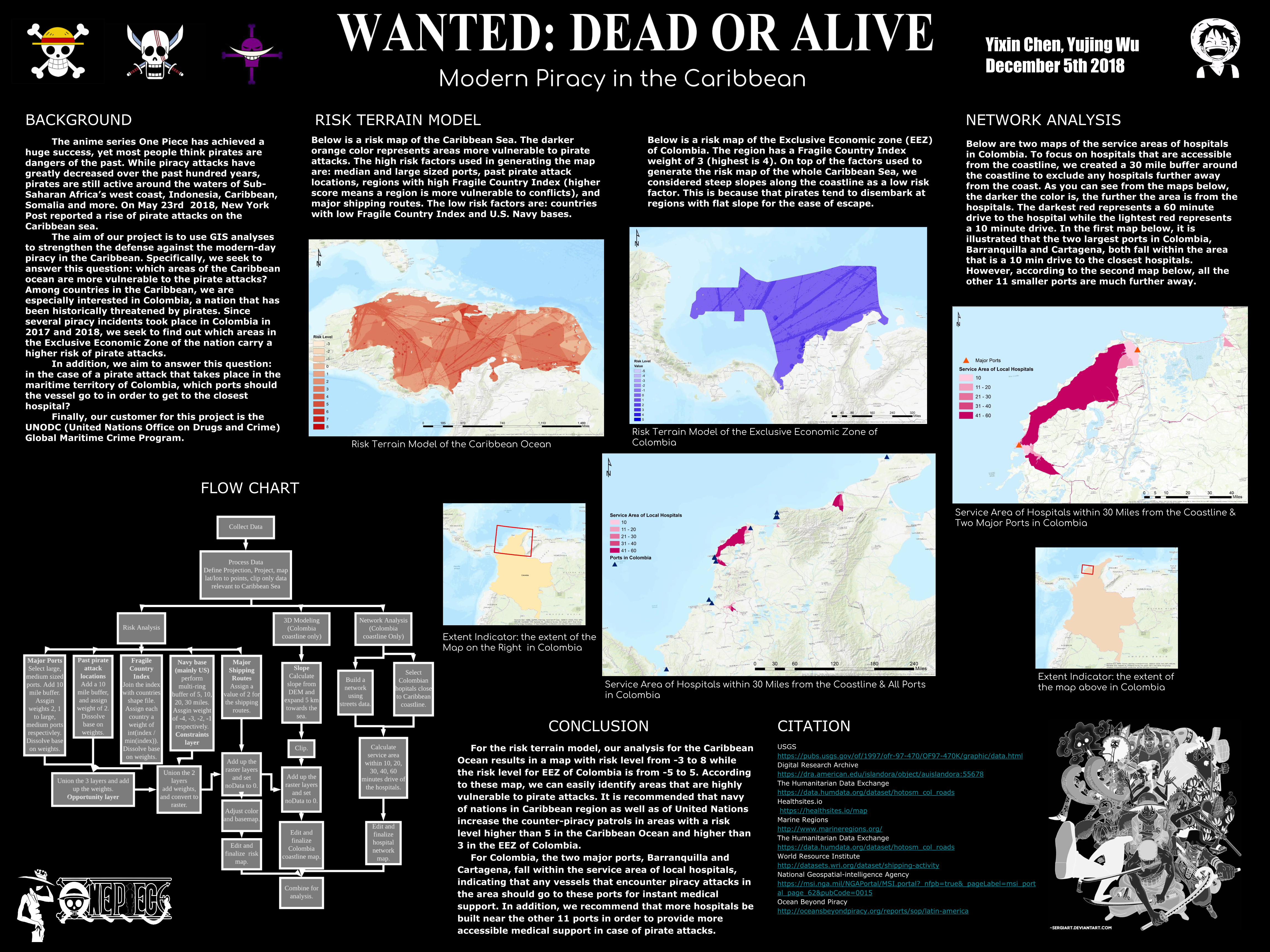
For Colombia, the two major ports, Barranquilla and
Cartagena, fall within the service area of local hospitals,
indicating that any vessels that encounter piracy attacks in
the area should go to these ports for instant medical
support. In addition, we recommend that more hospitals be
built near the other 11 ports in order to provide more
accessible medical support in case of pirate attacks.
Risk Terrain Model of the Caribbean Ocean
Service Area of Hospitals within 30 Miles from the Coastline & Two Major Ports in Colombia
Risk Terrain Model of the Exclusive Economic Zone of Colombia
Below is a risk map of the Caribbean Sea. The darker orange color represents areas more vulnerable to pirate attacks. The high risk factors used in generating the map are: median and large sized ports, past pirate attack locations, regions with high Fragile Country Index (higher score means a region is more vulnerable to conflicts), and major shipping routes. The low risk factors are: countries with low Fragile Country Index and U.S. Navy bases.
Extent Indicator: the extent of the map above in Colombia
Below is a risk map of the Exclusive Economic zone (EEZ) of Colombia. The region has a Fragile Country Index weight of 3 (highest is 4). On top of the factors used to generate the risk map of the whole Caribbean Sea, we considered steep slopes along the coastline as a low risk factor. This is because that pirates tend to disembark at regions with flat slope for the ease of escape.
Service Area of Hospitals within 30 Miles from the Coastline & All Ports in Colombia
Extent Indicator: the extent of the Map on the Right in Colombia
Below are two maps of the service areas of hospitals in Colombia. To focus on hospitals that are accessible from the coastline, we created a 30 mile buffer around the coastline to exclude any hospitals further away from the coast. As you can see from the maps below, the darker the color is, the further the area is from the hospitals. The darkest red represents a 60 minute drive to the hospital while the lightest red represents a 10 minute drive. In the first map below, it is illustrated that the two largest ports in Colombia, Barranquilla and Cartagena, both fall within the area that is a 10 min drive to the closest hospitals. However, according to the second map below, all the other 11 smaller ports are much further away.