Embed Size (px)
Citation preview

Sector St. Petersburg
Sector Jacksonville
Sector Key
West
Secto
r Mob
ile
Sector Miami
CoquinaKey
PineyPt.
LittleBayou
BishopHarbor
PointPinellas
Pinellas CountyAquatic Preserve
k
Cockroach BayAquatic Preserve
CockroachBay
AquaticPreserve
k
CockroachBay
PreserveState Park
Terra CeiaAquatic
Preserve
Terra CeiaAquatic
Preserve
Big
Bayou
Salt Cr.
T a m p aB a y
CockroachBay
LittleCockroach
Bay
Ta m p aB a y
St. PetersburgHilton ICP
WPFLN34-07NE Skyway Causeway
Seagrass Flats
WPFLN34-03Little Bayou
WPFLN35-04Florida SERF
ResearchFacility
WPFLN35-06Pinellas Point/CoquinaSeagrass Beds
WPFLN35-01Little Cockroach Bay
WPFLN37-01Bishop Harbor(Harbor Key to Mariposa)
WPFLN35-03 -Cockroach Bay(Piney Point Creek)
WPFLN35-02Cockroach Bay
WPFLN32-02Bayboro Harbor
WPFLN34-13Big Bayou
WPFLN31-09Albert Whitted Airport(tern nesting site)
WPFLN35-05Port ManateeSpoil Island/Manbirtee Key
XXX
XXX
XXX
XXX
XX
XX
XX
XX
XXXXXX
XXX
!S(
!S(
!S(
!S(
[]
!S(
!S(
##
#
!h(
#
#
!E(
!E(
!E(
!R(
!R(
200
300
300
400
500
500
500
500
600
800
1000
1600
1000
1100
1100
1300
1300
1400
1400
1400
1500
1600
17001700
2100
2200
2800
2900
3200
2000
4800
4600
5100
6300
8200
11500
9400
12800
18300
[s
!q
!̂
!̂
!·
!·
k
k
k
k
!d
!d
!d
!d
!d!d
!d
!d
Bayboro Harbor
PINEL
LAS C
OUNT
YHIL
LSBO
ROUG
H COU
NTY
!d
2800
PINELLAS COUNTY
HILLSBOROUGH COUNTY
#
#
T a m p a B a y
PINELLAS COUNTY
HILLSBOROUGH COUNTY
1400
Little
Cockroach
Bay
Cockroach Bay
Piney Pt. Creek
TECOTract
k
SERF WaterIntake
HILLSBOROUGH COUNTYMANATEE COUNTY
Shell Point
k
Manbir tee KeyPort Manatee
Bahia BeachArtificial Reef
Port Manatee Artificial Reef Project
£¤41
MangrovePt.
#
T a m p a B a y
Bird Key #
HILLSBOROUGH COUNTY
MANATEE COUNTY
HarborKey
£¤41
!S(
!S(
!S(
!d
!d
Big Bayou
[m
82°30'0"W
82°30'0"W
82°37'30"W
82°37'30"W27
°45'0"
N
27°45
'0"N
27°37
'30"N
27°37
'30"N
Bio-Socioeconomic[\ Beach Access
!· Airport
[y Aquaculture
[k Aquatic Preserve/State Park
!̂ Artificial Reef/Hardbottom
!¢ Bird Rookery
[z Black Bear Habitat
!d Boat Ramp
[s Coast Guard
[¼ Diving
!Å Heliport
[m High Recreational Beach
[¿ Historical Site
!¤ Manatee
[]Marina
[v NERR
[j National Park
[« Piping Plover
!d( Power Plant
!¶ Sea Turtle Nesting
!(RSeagrass
[¡ Smalltooth Sawfish
[AZ Spring
[¡ Sturgeon
!q Water Intake
[r Wildlife Refugeµ0 0.5 1 1.5 2
Miles
Map Continued on Page: WPFLN-31Ma
p Con
tinue
d on P
age:
WPFL
N-34
Geographic Response Plan Map: WPFLN-35Map Continued on Page: WPFLN-36
Map Continued on Page: WPFLN-37
MangrovesSea Turtle Nesting BeachAquaculture LeasesFederal Managed AreasState Managed AreasState Waters/County LineUSCG Sector Boundary
Environmentally Sensitive Areas Summer Protection PriorityXXXA - Protect First XX B - Protect after A AreasX C - Protect after B Areas
Response MethodsSkimmer
!h( Shallow Water Skimmer# Collection Point
General Booming Strategy(Length in Feet)
Incident Command Posts
!S( Staging Areas
!R( Oil Spill Risk Sites
!E( Equipment Storage LocationsF Tidal Inlet Protection Strategy
West Central FloridaArea Committee
Fish and Wildlife Research Institute

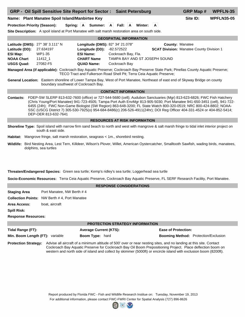
GRP - Oil Spill Sensitive Site Report for Sector : Saint Petersburg GRP Map # WPFLN-35
Fall: ASpring: A Winter: A
Site ID: WPFLN35-01Name: Little Cockroach Bay
Site Description: Shallow embayment connected to Middle Tampa Bay & Little Manatee River by tidal inlets amidst mangrove islands.
Protection Priority (Season):
County: Hillsborough
General Location: Southeastern Middle Tampa Bay, Hillsborough County, northwest of Cockroach Bay, southwest of Little Manatee River & Ruskin.
SCAT Division: Hillsborough County Division 2
Managed Area (if applicable): Cockroach Bay Aquatic Preserve; Cockroach Bay Preserve State Park; Pinellas County Aquatic Preserve; TECO Tract and Fulkerson Road Shell Pit; Terra Ceia Aquatic Preserve; Cockroach Bay
Latitude (DMS): 27° 42' 29.553" Longitude (DMS): 82° 30' 2.228" W
Latitude (DD): 27.708209 Longitude (DD): -82.500619
GEOSPATIAL INFORMATION
ESI Map: WP1-35 ESI Name: Cockroach Bay, Fla.
NOAA Chart 11412_1 CHART Name TAMPA BAY AND ST JOSEPH SOUND
USGS Quad: 27082-F5 QUAD Name: Cockroach Bay
CONTACT INFORMATION
Contacts: Rookery Bay NERR (Director) 239-417-6310 or 239-253-8943; Tampa Port Authority (Environmental Mgr) 813-905-5030; Hillsborough EPC Manatee Mgmt. 813-627-2600x1011; FDEP-Southwest District (Tampa) 813-632-7600; Audubon Sanctuaries (Manager) 813-623-6826; FWC Non-Game Biologist (SW Region) 863-648-3200; FL State Watch 800-320-0519; NRC 800-424-8802; NOAA-SSC (USCG District 7) 305-530-7925(o) 954-684-8486(c) 206-526-4911(24hr); DOI Reg Officer 404-331-4524 or 404-852-5414; DEP-OER 813-632-7641
RESOURCES AT RISK INFORMATION
Shoreline Type: Mangrove fringe, islands & tidal inlets.
Habitat: Extensive mangrove, Seagrass (<1m), Marsh, Oyster Bars, Shellfish, Tidal Flats, Outstanding Florida waters, St. Aquatic Preserve, Hillsborough County Seagrass and Manatee Management Areas, EPCHC-Tom Ash-(813) 627-2600 x 1011
Wildlife: Audubon Sanctuary, Seagrass Restoration Area, Brown Pelican, Wading Birds, Fisheries, Roseate Spoonbill, Oyster Bars, Smalltooth Sawfish, manatees, dolphins, sea turtles, American Bald Eagle
Threaten/Endangered Species: Manatee, Sea Turtles
Socio-Economic Resources:
RESPONSE CONSIDERATIONS
Staging Area Bahia Beach Marina, Shell Point Marina, E. G. Simmons Park (shallow draft), Piney Point Boat Ramp (sand), Mangrove Point, Cockroach Bay Boat Ramp (shallow),
Collection Points: Piney Point, Shell Point, Mangrove Point, Apollo Beach, Bahia Beach
Area Access: vehicle, boat, helicopter
Spill Risk:
Response Resources:
PROTECTION STRATEGY INFORMATION
Min. Boom Length (FT): 5000 Booming Method: Deflection, Protection/Exclusion
Boom Type: Hard
Protection Strategy: Deflect south to Piney Point, Northeast to Shell Point or North to Mangrove Point. Tidal seagrasses along entire shoreline should be boomed @ 1m contour. Secondary strategy: Block off inlet passes with harbor boom from Tropical Island at the northern entrance to the southern entrance to Little Cockroach Bay at Big Pass Key (~5000ft total). Keep collection statements.
Tidal Range (FT): Average Current (KTS): Ease of Protection:
Summer: A
Tuesday, November 19, 2013Report produced by Florida FWC - Fish and Wildlife Research Institue on:
For additional information, please contact FWC-FWRI Center for Spatial Analysis (727) 896-8626

GRP - Oil Spill Sensitive Site Report for Sector : Saint Petersburg GRP Map # WPFLN-35
Fall: ASpring: A Winter: A
Site ID: WPFLN35-02Name: Cockroach Bay
Site Description: An embayment connected to Middle Tampa Bay by extensively braided tidal inlets bordered by mangrove islands & fringes.
Protection Priority (Season):
County: Hillsborough
General Location: Southeastern MiddleTampa Bay, Hillsborough County, southwest of Little Manatee River & Ruskin.
SCAT Division: Hillsborough County Division 2
Managed Area (if applicable): Cockroach Bay Aquatic Preserve; Cockroach Bay Preserve State Park; Pinellas County Aquatic Preserve; TECO Tract and Fulkerson Road Shell Pit; Terra Ceia Aquatic Preserve;
Latitude (DMS): 27° 40' 55.999" Longitude (DMS): 82° 31' 53.000"
Latitude (DD): 27.682222 Longitude (DD): -82.531389
GEOSPATIAL INFORMATION
ESI Map: WP1-35 ESI Name: Cockroach Bay, Fla.
NOAA Chart 11412_1 CHART Name TAMPA BAY AND ST JOSEPH SOUND
USGS Quad: 27082-F5 QUAD Name: Cockroach Bay
CONTACT INFORMATION
Contacts: Rookery Bay NERR (Director) 239-417-6310 or 239-253-8943; Tampa Port Authority (Environmental Mgr) 813-905-5030; Hillsborough EPC Manatee Mgmt. 813-627-2600x1011; FDEP-Southwest District (Tampa) 813-632-7600; Audubon Sanctuaries (Manager) 813-623-6826; FWC Non-Game Biologist (SW Region) 863-648-3200; FL State Watch 800-320-0519; NRC 800-424-8802; NOAA-SSC (USCG District 7) 305-530-7925(o) 954-684-8486(c) 206-526-4911(24hr); DOI Reg Officer 404-331-4524 or 404-852-5414; DEP-OER 813-632-7641
RESOURCES AT RISK INFORMATION
Shoreline Type: Mangrove fringe, islands & tidal inlets.
Habitat: Extensive mangrove, sea grass, marsh, oyster bars, St. Aquatic Preserve, marsh restoration, tidal flats, Hillsborough County Seagrass and Manatee Management Areas (contact EPCHC)
Wildlife: Audubon sanctuary, sea grass restoration area, Brown Pelican, Roseate Spoonbill, fisheries, osprey, shellfish harvesting, archeological mound, Smalltooth Sawfish, wading birds, manatees, dolphins, sea turtles, American Bald Eagle
Threaten/Endangered Species: Manatee, Sea Turtles
Socio-Economic Resources: Cockroach Bay Aquatic Preserve, Shellfish Harvesting Area, Outstanding Florida Waters (L.M.R.)
RESPONSE CONSIDERATIONS
Staging Area Bahia Beach Marina, Shell Point Marina, E. G. Simmons Park (shallow draft), Piney Point Boat Ramp (sand), Mangrove Point, Cockroach Bay Boat Ramp (shallow),
Collection Points: Piney Point, Shell Point, Mangrove Point (private gate), Apollo Beach, Bahia Beach
Area Access: vehicle, boat, helicopter
Spill Risk:
Response Resources:
PROTECTION STRATEGY INFORMATION
Min. Boom Length (FT): 4300 Booming Method: Deflection, Protection/Exclusion
Boom Type: Hard
Protection Strategy: Boom off 1m contour. Secondary strategy: block off inlet passes to Cockroach Bay with harbor boom (4300ft).
Tidal Range (FT): Average Current (KTS): Ease of Protection:
Summer: A
Tuesday, November 19, 2013Report produced by Florida FWC - Fish and Wildlife Research Institue on:
For additional information, please contact FWC-FWRI Center for Spatial Analysis (727) 896-8626

GRP - Oil Spill Sensitive Site Report for Sector : Saint Petersburg GRP Map # WPFLN-35
Fall: ASpring: A Winter: A
Site ID: WPFLN35-03Name: Cockroach Bay (Piney Point Creek)
Site Description: A braided tidal creek in aquatic preserve with mangrove fringe and islands, tidal < 1m. seagrass flats.
Protection Priority (Season):
County: Hillsborough
General Location: Southeast Middle Tampa Bay, northeast of Port Manatee, southwest of Cockroach Bay & Little Manatee River.
SCAT Division: Hillsborough County Division 2
Managed Area (if applicable): Cockroach Bay Aquatic Preserve; Cockroach Bay Preserve State Park; Pinellas County Aquatic Preserve; TECO Tract and Fulkerson Road Shell Pit; Terra Ceia Aquatic Preserve;
Latitude (DMS): 27° 39' 50.000" Longitude (DMS): 82° 32' 33.000"
Latitude (DD): 27.663889 Longitude (DD): -82.542500
GEOSPATIAL INFORMATION
ESI Map: WP1-35 ESI Name: Cockroach Bay, Fla.
NOAA Chart 11412_1 CHART Name TAMPA BAY AND ST JOSEPH SOUND
USGS Quad: 27082-F5 QUAD Name: Cockroach Bay
CONTACT INFORMATION
Contacts: Rookery Bay NERR (Director) 239-417-6310 or 239-253-8943; Tampa Port Authority (Environmental Mgr) 813-905-5030; Hillsborough EPC Manatee Mgmt. 813-627-2600x1011; FDEP-Southwest District (Tampa) 813-632-7600; Audubon Sanctuaries (Manager) 813-623-6826; FWC Non-Game Biologist (SW Region) 863-648-3200; FL State Watch 800-320-0519; NRC 800-424-8802; NOAA-SSC (USCG District 7) 305-530-7925(o) 954-684-8486(c) 206-526-4911(24hr); DOI Reg Officer 404-331-4524 or 404-852-5414; DEP-OER 813-632-7641
RESOURCES AT RISK INFORMATION
Shoreline Type: Mangrove fringe, oyster beds, seagrass flats < 1m., salt marsh.
Habitat: Extensive mangrove, sea grass, marsh, oyster bars, tidal flats, St. Aquatic Preserve, Hillsborough County Seagrass and Manatee Management Areas, EPCHC-Tom Ash-(813) 627-2600 x 1011
Wildlife: Audubon sanctuary, sea grass restoration area, Brown Pelican, Roseate Spoonbill, osprey, wading birds, Smalltooth Sawfish, manatees, dolphins, sea turtles, American Bald Eagle
Threaten/Endangered Species: Manatee, Sea Turtles
Socio-Economic Resources: Cockroach Bay Aquatic Preserve, Shellfish harvesting, Recreational fisheries.
RESPONSE CONSIDERATIONS
Staging Area Bahia Beach Marina, Shell Point Marina, E. G. Simmons Park (shallow draft), Piney Point Boat Ramp (sand), Mangrove Point, Cockroach Bay Boat Ramp (shallow),
Collection Points: Piney Point, Shell Point, Mangrove Point, Apollo Beach
Area Access: vehicle, boat, helicopter
Spill Risk:
Response Resources:
PROTECTION STRATEGY INFORMATION
Min. Boom Length (FT): 4300 Booming Method: Deflection, Protection/Exclusion
Boom Type: Hard
Protection Strategy: Block off the mouth of Piney Point Creek with 500 feet of harbor boom (note: there are two sections that require booming). Deflect south to Piney Point or north to Mangrove Point. NOTE: if deflected north, other areas north must also be boomed to protect natural resources. The area northward between Piney Point Creek and Mangrove Point, is not accessible by any any mode of land transportation. All booming and recovery must be performed by water. Collection can also be performed as far north as Apollo Beach but environmental and distance factors must be considered, recommended Bahia Beach as northern most collection point. Deploy boom to block off 1m contour and deflect to Piney Pt. Contact Cockroach Bay Aquatic Preserve for Cockroach Bay Oil Boom Prepositioning Project.
Tidal Range (FT): Average Current (KTS): Ease of Protection:
Summer: A
Tuesday, November 19, 2013Report produced by Florida FWC - Fish and Wildlife Research Institue on:
For additional information, please contact FWC-FWRI Center for Spatial Analysis (727) 896-8626

GRP - Oil Spill Sensitive Site Report for Sector : Saint Petersburg GRP Map # WPFLN-35
Fall: ASpring: A Winter: A
Site ID: WPFLN35-04Name: Florida SERF Research Facility
Site Description:
Protection Priority (Season):
County: Manatee
General Location:
SCAT Division: Manatee County Division 1
Managed Area (if applicable): Cockroach Bay Aquatic Preserve; Cockroach Bay Preserve State Park; Pinellas County Aquatic Preserve; TECO Tract and Fulkerson Road Shell Pit; Terra Ceia Aquatic Preserve;
Latitude (DMS): 27° 38' 40.171" Longitude (DMS): 82° 32' 43.190"
Latitude (DD): 27.644492 Longitude (DD): -82.545330
GEOSPATIAL INFORMATION
ESI Map: WP1-35 ESI Name: Cockroach Bay, Fla.
NOAA Chart 11412_1 CHART Name TAMPA BAY AND ST JOSEPH SOUND
USGS Quad: 27082-F5 QUAD Name: Cockroach Bay
CONTACT INFORMATION
Contacts: FWC Fish Hatchery (Chris Young/Port Manatee Facility) 941-723-4505; Manatee County Natural Resources (Director) 941-748-4501; FDEP-Southwest District (Tampa) 813-632-7600; Audubon Sanctuaries (Manager) 813-623-6826; FWC Non-Game Biologist (SW Region) 863-648-3200; FL State Watch 800-320-0519; NRC 800-424-8802; NOAA-SSC (USCG District 7) 305-530-7925(o) 954-684-8486(c) 206-526-4911(24hr); DOI Reg Officer 404-331-4524 or 404-852-5414; DEP-OER 813-632-7641
RESOURCES AT RISK INFORMATION
Shoreline Type: Exposed tidal flats; Fine-medium grained sand beaches; Freshwater marshes; Mixed sand and gravel beaches; Scrub-shrub wetlands; Swamps
Habitat: Seagrass; Mangrove
Wildlife: diving birds; shorebirds; wading birds; waterfowl; Blue crab; Stone crab; Pink shrimp; Green sea turtle; Kemp's ridley sea turtle; Loggerhead sea turtle
Threaten/Endangered Species: Green sea turtle; Kemp's ridley's sea turtle; Loggerhead sea turtle
Socio-Economic Resources: Aquaculture Facility and water intake
RESPONSE CONSIDERATIONS
Staging Area
Collection Points:
Area Access:
Spill Risk:
Response Resources:
PROTECTION STRATEGY INFORMATION
Min. Boom Length (FT): 3900 Booming Method: Deflection, Protection/Exclusion
Boom Type: Hard
Protection Strategy: Contact Cockroach Bay Aquatic Preserve for Cockroach Bay Oil Boom Prepositioning Project. Shut down water intake.
Tidal Range (FT): Average Current (KTS): Ease of Protection:
Summer: A
Tuesday, November 19, 2013Report produced by Florida FWC - Fish and Wildlife Research Institue on:
For additional information, please contact FWC-FWRI Center for Spatial Analysis (727) 896-8626
GRP - Oil Spill Sensitive Site Report for Sector : Saint Petersburg GRP Map # WPFLN-35
Fall: ASpring: A Winter: A
Site ID: WPFLN35-05Name: Plant Manatee Spoil Island/Manbirtee Key
Site Description: A spoil island at Port Manatee with salt marsh restoration area on south side.
Protection Priority (Season):
County: Manatee
General Location: Eastern shoreline of Lower Tampa Bay, West of Port Manatee, Northeast of east end of Skyway Bridge on county boundary southwest of Cockroach Bay.
SCAT Division: Manatee County Division 1
Managed Area (if applicable): Cockroach Bay Aquatic Preserve; Cockroach Bay Preserve State Park; Pinellas County Aquatic Preserve; TECO Tract and Fulkerson Road Shell Pit; Terra Ceia Aquatic Preserve;
Latitude (DMS): 27° 38' 3.111" N Longitude (DMS): 82° 34' 21.078"
Latitude (DD): 27.634197 Longitude (DD): -82.572522
GEOSPATIAL INFORMATION
ESI Map: WP1-35 ESI Name: Cockroach Bay, Fla.
NOAA Chart 11412_1 CHART Name TAMPA BAY AND ST JOSEPH SOUND
USGS Quad: 27082-F5 QUAD Name: Cockroach Bay
CONTACT INFORMATION
Contacts: FDEP-SW SLERP 813-632-7600 (office) or 727-544-5680 (cell); Audubon Sanctuaries (Mgr) 813-623-6826; FWC Fish Hatchery (Chris Young/Port Manatee) 941-723-4505; Tampa Port Auth EnvMgr 813-905-5030; Port Manatee 941-650-3451 (cell), 941-722-6455 (24h); FWC Non-Game Biologist (SW Region) 863-648-3200; FL State Watch 800-320-0519; NRC 800-424-8802; NOAA-SSC (USCG District 7) 305-530-7925(o) 954-684-8486(c) 206-526-4911(24hr); DOI Reg Officer 404-331-4524 or 404-852-5414; DEP-OER 813-632-7641
RESOURCES AT RISK INFORMATION
Shoreline Type: Spoil island with narrow firm sand beach to north and west with mangrove & salt marsh fringe to tidal inlet interior project on south & east side.
Habitat: Mangrove fringe, salt marsh restoration, seagrass < 1m., shorebird nesting.
Wildlife: Bird Nesting Area, Lest Tern, Killdeer, Wilson's Plover, Willet, American Oystercatcher, Smalltooth Sawfish, wading birds, manatees, dolphins, sea turtles
Threaten/Endangered Species: Green sea turtle; Kemp's ridley's sea turtle; Loggerhead sea turtle
Socio-Economic Resources: Terra Ceia Aquatic Preserve, Cockroach Bay Aquatic Preserve, FL SERF Research Facility, Port Manatee.
RESPONSE CONSIDERATIONS
Staging Area Port Manatee, NW Berth # 4
Collection Points: NW Berth # 4, Port Manatee
Area Access: boat, aircraft
Spill Risk:
Response Resources:
PROTECTION STRATEGY INFORMATION
Min. Boom Length (FT): variable Booming Method: Protection/ExclusionBoom Type: hard
Protection Strategy: Advise all aircraft of a minimum altitude of 500' over or near nesting sites, and no landing at this site. Contact Cockroach Bay Aquatic Preserve for Cockroach Bay Oil Boom Prepositioning Project. Place deflection boom on western and north side of island and collect by skimmer (5000ft) or encircle island with exclusion boom (8200ft).
Tidal Range (FT): Average Current (KTS): Ease of Protection:
Summer: A
Tuesday, November 19, 2013Report produced by Florida FWC - Fish and Wildlife Research Institue on:
For additional information, please contact FWC-FWRI Center for Spatial Analysis (727) 896-8626

GRP - Oil Spill Sensitive Site Report for Sector : Saint Petersburg GRP Map # WPFLN-35
Fall: ASpring: A Winter: A
Site ID: WPFLN35-06Name: Pinellas Point/Coquina Seagrass Beds
Site Description:Protection Priority (Season):
County: Pinellas
General Location: Tampa Bay, off of Coquina Key and Pinellas Point
SCAT Division: Pinellas County Division 2
Managed Area (if applicable): Boca Ciega Bay Aquatic Preserve; Pinellas County Aquatic Preserve; Pinellas NWR; Skyway Fishing Pier State Park;
Latitude (DMS): 27° 43' 16.178" N Longitude (DMS): 82° 37' 8.505" WLatitude (DD): 27.721161 Longitude (DD): -82.619029
GEOSPATIAL INFORMATION
ESI Map: WP1-35 ESI Name: Cockroach Bay, Fla.NOAA Chart 11412_1 CHART Name TAMPA BAY AND ST JOSEPH SOUNDUSGS Quad: 27082-F5 QUAD Name: Cockroach Bay, Fla.
CONTACT INFORMATIONContacts: Rookery Bay NERR (main) 239-417-6310; Pinellas County: Coastal Management (727-464-4633), Parks & Conservation (727-582-
2100), Watershed Mgt. (727-464-4425); City of St. Pete (Parks) 727-893-7441 FWC Non-Game Biologist (SW Region) 863-648-3200; FL State Watch 800-320-0519; NRC 800-424-8802; NOAA-SSC (USCG District 7) 305-530-7925(o) 954-684-8486(c) 206-526-4911(24hr); DOI Reg Officer 404-331-4524 or 404-852-5414; DEP-OER 813-632-7641
RESOURCES AT RISK INFORMATIONShoreline Type: mangrove, seawall
Habitat: Extensive high-quality shallow seagrasses (<1m); nursery areas; tidal flats
Wildlife: Manatee, wading birds, oyster beds, all marine species dependent on seagrass habitat including juvenile game fish, Brown Pelican, little blue heron, osprey, reddish egret, Roseate Spoonbill, snowy egret, tricolored heron, white ibis
Threaten/Endangered Species: Manatee
Socio-Economic Resources:
RESPONSE CONSIDERATIONSStaging Area USCG Station-Sector St. Petersburg, Bay Vista Park Boat Ramp (aka Pinellas Point or Colony Point Drive),
Collection Points:Area Access: vehicle, helicopter, boat
Spill Risk:Response Resources:
PROTECTION STRATEGY INFORMATION
Min. Boom Length (FT): variable Booming Method: Deflection, Protection/Exclusion
Boom Type: Hard
Protection Strategy: Approximate length of seagrass flats=25000ft.
Tidal Range (FT): Average Current (KTS): Ease of Protection:
Summer: A
Friday, November 22, 2013Report produced by Florida FWC - Fish and Wildlife Research Institue on:For additional information, please contact FWC-FWRI Center for Spatial Analysis (727) 896-8626

GRP - Oil Spill Staging Area Report for Sector : Saint Petersburg GRP Map # WPFLN-35
Site ID: MA21317TYFacility Name: Piney Point Boat Ramp
Site Type: Boat Ramp
Latitude (DMS): 27° 38' 33.648" N Longitude (DMS): 82° 33' 29.340" W
Latitude (DD): 27.64268000 Longitude (DD): -82.55814999
GEOSPATIAL INFORMATION
GENERAL INFORMATION AND COMMENTS
Access: Government Owned for Government Business Only
Operational Status: Open For Business
Physical Address: Piney Point Road
County: ManateeCity: Palmetto Zip Code 34221State: Florida
Water Type: Water Body Name: Tampa Bay / Port Manatee
SITE DESCRIPTION
Boat Ramp Surface Composition: Poured in place concrete, Condition: Unknow
Parking Capacity for Cars: 0
Parking Surface: Gravel/Sand/DirtParking Lot Dimensions:
Access Constraints:
Parking Capacity for Trailers: 6
Boat Launch Capability:
Capable for Light or Heavy Equipment and Type:
Boom Available On-Site and Length:
Fuels Available:
Number of Moorings:Number of Boat Slips:
Water Depth at End of Boat Ramp:
Shoreline Type in Viewable Viscinity:
Crane Capabilities:
Collection Point Capabilities:
Wave Energy at Site:
ADDITIONAL AMMENITIES
Special/Pre-Planned Events and Dates:
Propane or Natural Gas Available
Water Available: Fire Hydrant:
Pumpout Available: Bathrooms Available: Unknown
Electricity Amperage Available: Camping Facilities:
Food Available: Security Available and Hours On Duty:
Comments: sand
Survey Date:Survey Type:Data Collector (Agency):
Managing Agency: Port Manatee
General Manager/Contact Person:
Contact Phone #: SCAT Description: Manatee County Division 1
Days of Operation:
Scale of Staging Area:
Hours of Operation: Unknown
Number of Boat Ramps: 1 Number of Boat Ramp Lanes: 1
Photo URL:
Thursday, November 21, 2013Report produced by Florida FWC - Fish and Wildlife Research Institue on:
For additional information, please contact FWC-FWRI Center for Spatial Analysis (727) 896-8626

GRP - Oil Spill Staging Area Report for Sector : Saint Petersburg GRP Map # WPFLN-35
Site ID:Facility Name: Port Manatee (NW Berth # 4)
Site Type: Staging Area
Latitude (DMS): 27° 38' 2.243" N Longitude (DMS): 82° 33' 28.191" W
Latitude (DD): 27.63395645 Longitude (DD): -82.55783090
GEOSPATIAL INFORMATION
GENERAL INFORMATION AND COMMENTS
Access:
Operational Status:
Physical Address: 300 Tampa Bay Way # 1
County: ManateeCity: Palmetto Zip Code 34221State: Florida
Water Type: Water Body Name:
SITE DESCRIPTION
Boat Ramp Surface Composition:
Parking Capacity for Cars:
Parking Surface:Parking Lot Dimensions:
Access Constraints:
Parking Capacity for Trailers:
Boat Launch Capability:
Capable for Light or Heavy Equipment and Type:
Boom Available On-Site and Length:
Fuels Available:
Number of Moorings:Number of Boat Slips:
Water Depth at End of Boat Ramp:
Shoreline Type in Viewable Viscinity:
Crane Capabilities:
Collection Point Capabilities:
Wave Energy at Site:
ADDITIONAL AMMENITIES
Special/Pre-Planned Events and Dates:
Propane or Natural Gas Available
Water Available: Fire Hydrant:
Pumpout Available: Bathrooms Available:
Electricity Amperage Available: Camping Facilities:
Food Available: Security Available and Hours On Duty:
Comments:
Survey Date:Survey Type:Data Collector (Agency):
Managing Agency: Manatee County Port Authority
General Manager/Contact Person:
Contact Phone #: Port Manatee Env. Mgr. 941-650-3451 (cell SCAT Description: Manatee County Division 1
Days of Operation:
Scale of Staging Area:
Hours of Operation:
Number of Boat Ramps: Number of Boat Ramp Lanes:
Photo URL:
Thursday, November 21, 2013Report produced by Florida FWC - Fish and Wildlife Research Institue on:
For additional information, please contact FWC-FWRI Center for Spatial Analysis (727) 896-8626

GRP - Oil Spill Staging Area Report for Sector : Saint Petersburg GRP Map # WPFLN-35
Site ID: HL00159AKFacility Name: Cockroach Bay Boat Ramp
Site Type: Boat Ramp
Latitude (DMS): 27° 41' 13.200" N Longitude (DMS): 82° 31' 13.300" W
Latitude (DD): 27.68699999 Longitude (DD): -82.52036110
GEOSPATIAL INFORMATION
GENERAL INFORMATION AND COMMENTS
Access:
Operational Status:
Physical Address: 5299 Cockroach Bay
County: HillsboroughCity: Ruskin Zip Code 33570State: Florida
Water Type: Salt Water Body Name: Tampa Bay
SITE DESCRIPTION
Boat Ramp Surface Composition:
Parking Capacity for Cars: 0
Parking Surface: Gravel/Sand/DirtParking Lot Dimensions:
Access Constraints:
Parking Capacity for Trailers: 30
Boat Launch Capability:
Capable for Light or Heavy Equipment and Type:
Boom Available On-Site and Length:
Fuels Available:
Number of Moorings: 0Number of Boat Slips: 0
Water Depth at End of Boat Ramp:
Shoreline Type in Viewable Viscinity:
Crane Capabilities:
Collection Point Capabilities:
Wave Energy at Site:
ADDITIONAL AMMENITIES
Special/Pre-Planned Events and Dates:
Propane or Natural Gas Available
Water Available: Fire Hydrant:
Pumpout Available: Bathrooms Available: No Restrooms
Electricity Amperage Available: No Electricity Available Camping Facilities:
Food Available: Security Available and Hours On Duty:
Comments:
Survey Date:Survey Type: Data Collector (Agency):
Managing Agency: FL Dept. Envir. Prot., Cockroach Bay Aquatic Pres.
General Manager/Contact Person: 813-975-2160
Contact Phone #: 813-975-2160 SCAT Description: Hillsborough County Division 2
Days of Operation:
Scale of Staging Area:
Hours of Operation: 24 hours
Number of Boat Ramps: 1 Number of Boat Ramp Lanes: 1
Photo URL: http://ocean.floridamarine.org/waterphotos/ramp_photos/photo_id/2508/index.htm
Thursday, November 21, 2013Report produced by Florida FWC - Fish and Wildlife Research Institue on:
For additional information, please contact FWC-FWRI Center for Spatial Analysis (727) 896-8626
GRP - Oil Spill Equipment Storage Location for Sector : Saint Petersburg GRP Map # WPFLN-35
Site ID: STP-E20Name: VOSS (Tampa, FL)Site Description:
County: Manatee
Physical Address: 300 Regal Cruise Way, Suite 1
Latitude (DMS): 27° 35' 16.001" N Longitude (DMS): 82° 30' 20.002" W
Latitude (DD): 27.632041 Longitude (DD): -82.560672
GEOSPATIAL INFORMATION
CONTACT INFORMATION
Contacts: Dave Adams (Phone: 305-415-6869, Email: [email protected])
EQUIPMENT INFORMATION
Equipment Type: Boom; Skimmers; Transfer Pumps; Temporary Storage
City: Palmetto 34221Zip CodeFloridaState:
Equipment: Boom-Fence (500'); Skimmers (Qty 2); Transfer Pumps (Qty 2); Temporary Storage-28000gal (Qty 2)
Tuesday, November 19, 2013Report produced by Florida FWC - Fish and Wildlife Research Institue on:For additional information, please contact FWC-FWRI Center for Spatial Analysis (727) 896-8626

GRP - Oil Spill Risk Site Report for Sector : Saint Petersburg GRP Map # WPFLN-35
Site ID: STP-R27Name: TRANSMONTAIGNE MANATEE
Site Description: MISLE ID=TAMOIL09
County: Manatee
Physical Address: 804 North Dock Street
Latitude (DMS): 27° 38' 9.567" N Longitude (DMS): 82° 33' 24.181" W
Latitude (DD): 27.63599082 Longitude (DD): -82.55671680
GEOSPATIAL INFORMATION
CONTACT INFORMATION
Contacts: 941-722-7727
RISK INFORMATION
Facility Type:
City: Palmetto 34221Zip Code
Types of Oil: Petroleum
Most Probable Risk
Maximum Risk:
Worst Case Discharge: The worst case/facility spill scenario is a catastrophic failure of a 250,000 barrel tank of #6 oil at Port Manatee, with 50,000 bbls escaping via mosquito ditch to the bay.oil at Port Manatee, with 50,000 bbls escaping via mosquito ditch to the bay.
State: Florida
Tuesday, November 19, 2013Report produced by Florida FWC - Fish and Wildlife Research Institue on:
For additional information, please contact FWC-FWRI Center for Spatial Analysis (727) 896-8626

GRP - Oil Spill Risk Site Report for Sector : Saint Petersburg GRP Map # WPFLN-35
Site ID: STP-R28Name: FLORIDA POWER & LIGHT COMPANY
Site Description: MISLE ID=TAMOIL16
County: Manatee
Physical Address: 12310 Reeder Road
Latitude (DMS): 27° 37' 31.873" N Longitude (DMS): 82° 32' 44.952" W
Latitude (DD): 27.62552036 Longitude (DD): -82.54582008
GEOSPATIAL INFORMATION
CONTACT INFORMATION
Contacts: 941-722-1163
RISK INFORMATION
Facility Type:
City: Palmetto 34221Zip Code
Types of Oil: Petroleum
Most Probable Risk
Maximum Risk:
Worst Case Discharge: 1,042,000 Gals. (Petroleum)
State: Florida
Tuesday, November 19, 2013Report produced by Florida FWC - Fish and Wildlife Research Institue on:
For additional information, please contact FWC-FWRI Center for Spatial Analysis (727) 896-8626