Embed Size (px)
Citation preview
1Stavanger (NO) Retooling Forus
North Sea Farmland Airport Sola Housing Gandafjorden
Business Axis
Commercial Axis
Cultural Axis
Forus HousingForus Industrial AreaParks
Combining the different programatic elements from across the region
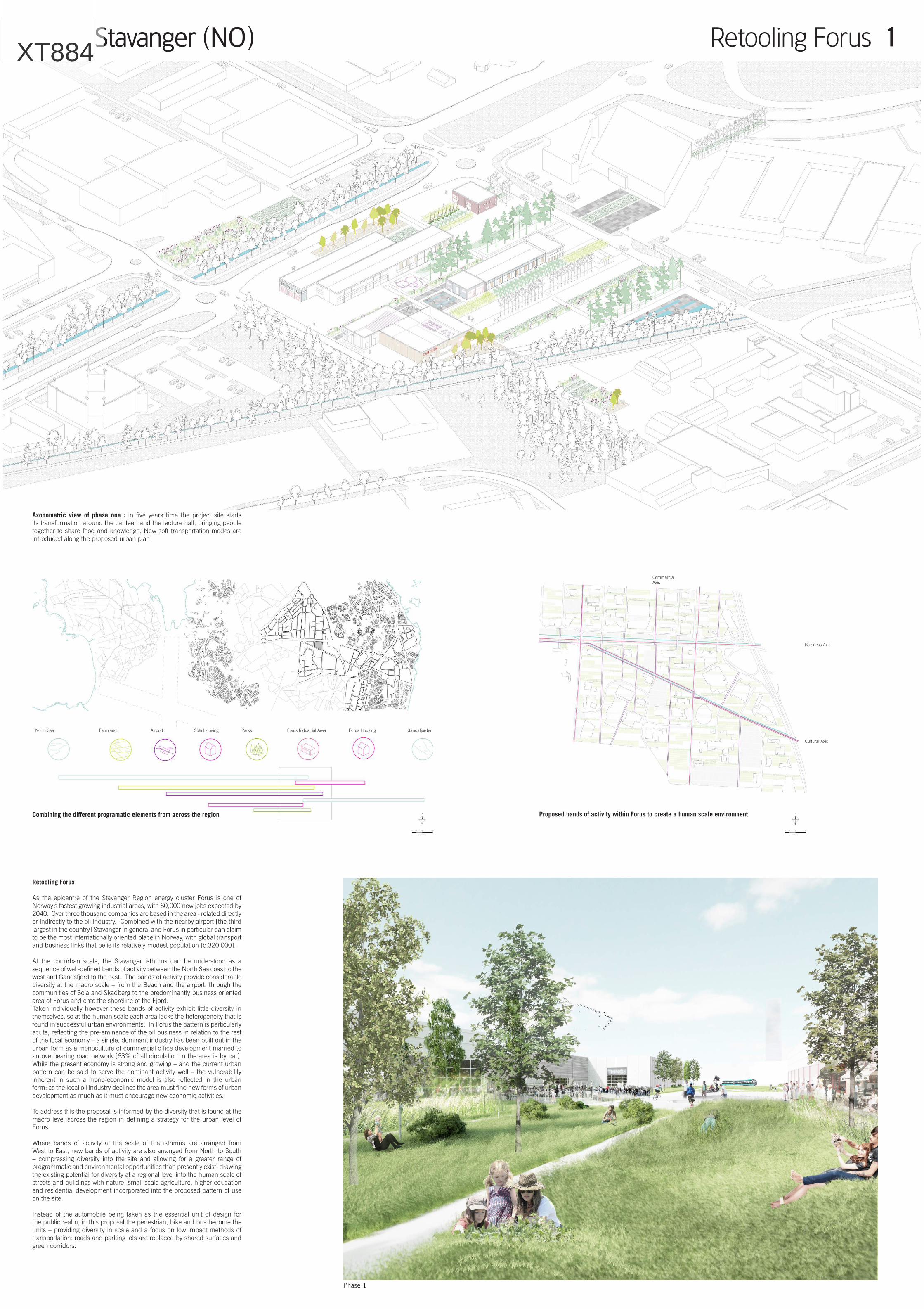
Axonometric view of phase one : in five years time the project site starts its transformation around the canteen and the lecture hall, bringing people together to share food and knowledge. New soft transportation modes are introduced along the proposed urban plan.
Proposed bands of activity within Forus to create a human scale environment
Phase 1
Retooling Forus
As the epicentre of the Stavanger Region energy cluster Forus is one of Norway’s fastest growing industrial areas, with 60,000 new jobs expected by 2040. Over three thousand companies are based in the area - related directly or indirectly to the oil industry. Combined with the nearby airport [the third largest in the country] Stavanger in general and Forus in particular can claim to be the most internationally oriented place in Norway, with global transport and business links that belie its relatively modest population [c.320,000].
At the conurban scale, the Stavanger isthmus can be understood as a sequence of well-defined bands of activity between the North Sea coast to the west and Gandsfjord to the east. The bands of activity provide considerable diversity at the macro scale – from the Beach and the airport, through the communities of Sola and Skadberg to the predominantly business oriented area of Forus and onto the shoreline of the Fjord.Taken individually however these bands of activity exhibit little diversity in themselves, so at the human scale each area lacks the heterogeneity that is found in successful urban environments. In Forus the pattern is particularly acute, reflecting the pre-eminence of the oil business in relation to the rest of the local economy – a single, dominant industry has been built out in the urban form as a monoculture of commercial office development married to an overbearing road network [63% of all circulation in the area is by car]. While the present economy is strong and growing – and the current urban pattern can be said to serve the dominant activity well – the vulnerability inherent in such a mono-economic model is also reflected in the urban form: as the local oil industry declines the area must find new forms of urban development as much as it must encourage new economic activities.
To address this the proposal is informed by the diversity that is found at the macro level across the region in defining a strategy for the urban level of Forus.
Where bands of activity at the scale of the isthmus are arranged from West to East, new bands of activity are also arranged from North to South – compressing diversity into the site and allowing for a greater range of programmatic and environmental opportunities than presently exist; drawing the existing potential for diversity at a regional level into the human scale of streets and buildings with nature, small scale agriculture, higher education and residential development incorporated into the proposed pattern of use on the site.
Instead of the automobile being taken as the essential unit of design for the public realm, in this proposal the pedestrian, bike and bus become the units – providing diversity in scale and a focus on low impact methods of transportation: roads and parking lots are replaced by shared surfaces and green corridors.
( IN METERS )
N
10005002000
( IN METERS )
N
5025100
XT884
Stavanger (NO) Retooling Forus 2
Network tools
Birch trees laneCyclist Tower Block RowBasketball Court
Volleyball Pitch
Swimming Pool
Skatepark
Canteen
Coworking space
Bike Repair Cafe
Market
Sauna
Social & Art Center
Library
Theater
Nursery
School
Playground
Mini Farm
Launderette
Post Office
Medical Center
Grocery Store
ForestPedestrian Side Tower Plug Block Plug Row Plug
DeckBus Tower Infill Block Infill Top
Field
Topography
High grass
Canal
Mineral
Garden
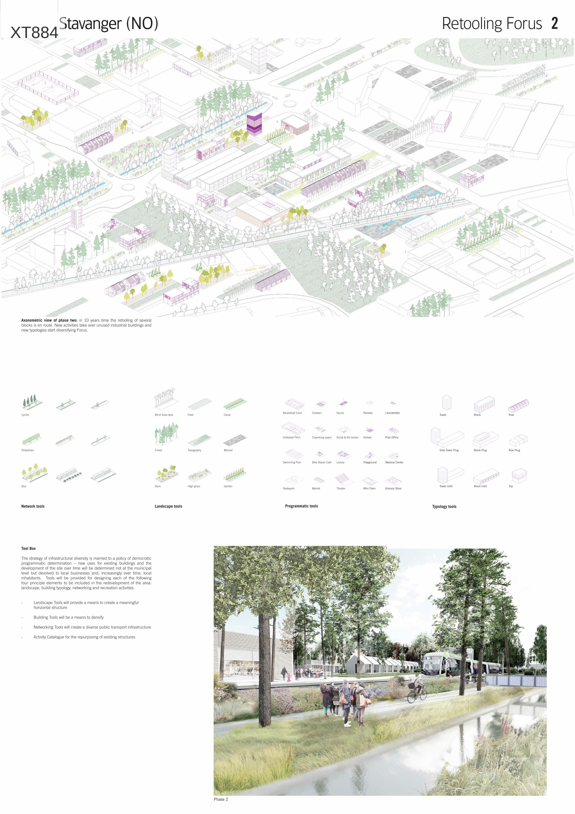
Axonometric view of phase two: in 10 years time the retooling of several blocks is en route. New activities take over unused industrial buildings and new typologies start diversifying Forus.
Phase 2
Landscape tools Programmatic tools Typology tools
Tool Box
The strategy of infrastructural diversity is married to a policy of democratic programmatic determination – new uses for existing buildings and the development of the site over time will be determined not at the municipal level but devolved to local businesses and, increasingly over time, local inhabitants. Tools will be provided for designing each of the following four principle elements to be included in the redevelopment of the area: landscape, building typology, networking and recreation activities.
- Landscape Tools will provide a means to create a meaningful horizontal structure
- Building Tools will be a means to densify
- Networking Tools will create a diverse public transport infrastructure
- Activity Catalogue for the repurposing of existing structures
XT884
Stavanger (NO) Retooling Forus 3
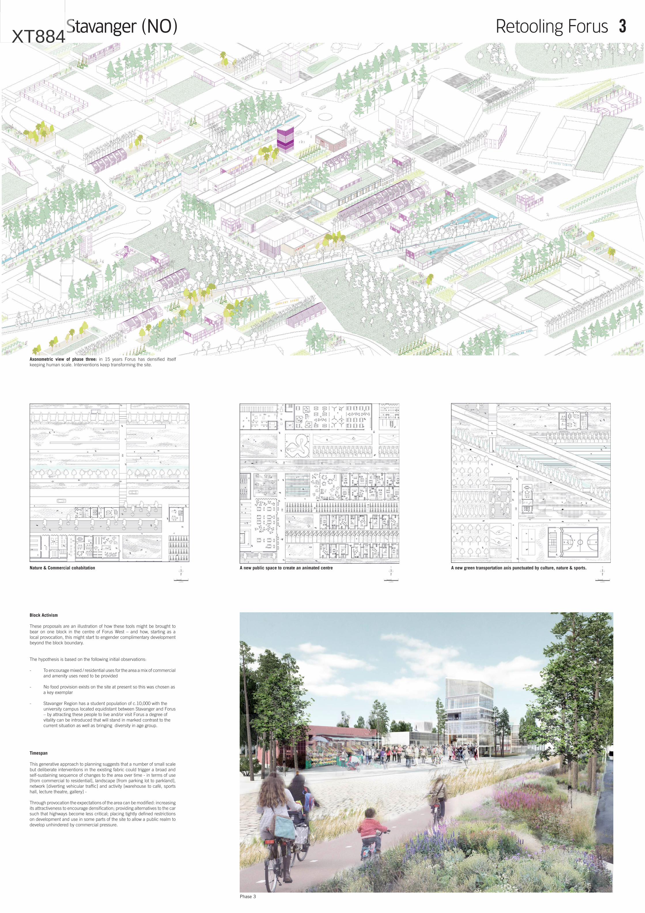
Axonometric view of phase three: in 15 years Forus has densified itself keeping human scale. Interventions keep transforming the site.
Phase 3
Nature & Commercial cohabitation A new public space to create an animated centre A new green transportation axis punctuated by culture, nature & sports.
Block Activism
These proposals are an illustration of how these tools might be brought to bear on one block in the centre of Forus West – and how, starting as a local provocation, this might start to engender complimentary development beyond the block boundary.
The hypothesis is based on the following initial observations:
- To encourage mixed / residential uses for the area a mix of commercial and amenity uses need to be provided
- No food provision exists on the site at present so this was chosen as a key exemplar
- Stavanger Region has a student population of c.10,000 with the university campus located equidistant between Stavanger and Forus – by attracting these people to live and/or visit Forus a degree of vitality can be introduced that will stand in marked contrast to the current situation as well as bringing diversity in age group.
Timespan
This generative approach to planning suggests that a number of small scale but deliberate interventions in the existing fabric could trigger a broad and self-sustaining sequence of changes to the area over time - in terms of use [from commercial to residential], landscape [from parking lot to parkland], network [diverting vehicular traffic] and activity [warehouse to café, sports hall, lecture theatre, gallery] -
Through provocation the expectations of the area can be modified: increasing its attractiveness to encourage densification; providing alternatives to the car such that highways become less critical; placing tightly defined restrictions on development and use in some parts of the site to allow a public realm to develop unhindered by commercial pressure.
( IN METERS )
N
10050200
( IN METERS )
N
10050200
( IN METERS )
N
10050200
XT884