Embed Size (px)
Citation preview

Wyoming Forest Health Report
A Baseline Assessment 1995 - 1998

Wyoming Forest Health Report
1995-1998
A BASELINE ASSESSMENT
Les Koch, Paul Rogers, Michelle Frank, Dave Atkins,
and Lia Spiegel
Photos provided by Wyoming Travel and Tourism
Les Koch, Wyoming State Forestry Division, Cheyenne, Wyoming Paul Rogers, USDA Forest Service, Rocky Mountain Research Station, Ogden, Utah Michelle Frank, USDA Forest Service, Rocky Mountain Region, Lakewood,Colorado Dave Atkins, USDA Forest Service, Northern Region, Missoula, Montana Lia Spiegel, USDA Forest Service, Pacific Northwest Region, LaGrande, Oregon
This research was supported in part by funds provided by the Rocky Mountain Research Station, Forest Service, U.S. Department of Agriculture
August 2001

Contents
Forest Health Highlights ......................................................................................................7
I. Introduction ......................................................................................................................9 Plot Component of Detection Monitoring.....................................................................11 Survey Component of Detection Monitoring ................................................................12 Scope of Report...........................................................................................................12 II. Wyoming’s Forest Resources ........................................................................................15 Land Ownership...........................................................................................................16 Forest Type..................................................................................................................17 Ecoregions...................................................................................................................18 Great Plains............................................................................................................19 Intermountain Semidesert .......................................................................................19 Southern Rockies ...................................................................................................20 Black Hills..............................................................................................................20 Plot and Tree Summary................................................................................................21 III. Forest Health Issues .....................................................................................................24 Forest Cover Change ...................................................................................................25 White pine blister rust.............................................................................................25 Riparian forest health.............................................................................................27 Aspen decline .........................................................................................................28 Insects and Diseases.....................................................................................................28 Dwarf mistletoes ....................................................................................................29 Comandra blister rust .............................................................................................29 Douglas-fir beetle...................................................................................................30 Mountain pine beetle ..............................................................................................30 Subalpine fir decline ...............................................................................................30 Air Quality ...................................................................................................................31 Biodiversity..................................................................................................................32 Urban Forests ..............................................................................................................34 Rural-Urban-Wildland Interface ...................................................................................34
Summary.............................................................................................................................37
References ...........................................................................................................................39
Appendices A. Plot distribution in the Interior West by state and land use................................................43 B. Distribution of forestland in Wyoming by stand-level categories, 1997..............................44 C. List of analytical variables from FHM plots.......................................................................45 D. Distribution of damage types for trees (5” dbh and larger) on Wyoming plots...................47 E. Visual crown ratings.........................................................................................................48 F. Species common and Latin names .....................................................................................50 G. Contacts for further information.......................................................................................52

Figures and Tables
Figures 1. FHM plot diagram............................................................................................................ 11 2. Land ownership in Wyoming (map) .................................................................................. 16 3. Ownership by percent area (pie chart)............................................................................... 16 4. Forest types of Wyoming (map)........................................................................................ 17 5. Forest types by percent area (pie chart) ............................................................................ 17 6. Forested plots by ecoregion in Wyoming (map) ................................................................ 18 7. Mature trees sampled in Wyoming (bar graph).................................................................. 21 8. Regeneration sampled in Wyoming (bar graph)................................................................. 22 9. White pine blister rust: incidence and severity (map)......................................................... 26 10. Percent change in population for Wyoming counties: 1990 to 2000 (map) ...................... 35 Table 1. Percent forest type by ecoregion in Wyoming ................................................................... 21

7
Forest Health Highlights
Forest health monitoring has been active in Wyoming since 1995. This report reflects four years
of Detection Monitoring and provides a baseline assessment of forest conditions in Wyoming. The
following highlights represent some of the more important facts and conclusions presented in this
report.
� Wyoming covers approximately 62.6 million acres in which 9.8 million acres are forested or 16 percent of the land area. Roughly 1.4 million forested acres are in state and private ownership; 8.2 million acres are federally owned; and Tribal lands account for 208,000 acres.
� Approximately 42 percent of Wyoming’s lands are privately owned with most located in the
eastern Great Plains. The Bureau of Land Management has nearly double the land ownership of the Forest Service with percentages at 28 and 15, respectively.
� There were ten forest types and four ecoregions identified. The Southern Rockies ecoregion
supports seven of the eight forest types. The Semidesert ecoregion covers the largest area. � Lodgepole pine is the most common forest type in Wyoming, with spruce/fir and ponderosa pine
forest types ranking slightly behind. � Limber pine, whitebark pine, cottonwood, and aspen appear to be declining due to diseases,
changes in fire frequency, introduced plants, and changes in water flow. � Insects and diseases play perennial roles in the health of the state’s forests. Dwarf mistletoes and
Comandra blister rust are at high levels. Douglas-fir beetle populations are increasing in northwest Wyoming. Subalpine fir is undergoing extensive mortality from a complex of factors.
� Exotic plants and tree diseases are changing forest communities. � Three species comprise 44 percent of Wyoming’s urban street trees. This lack of diversity puts
urban forest at risk from damaging agents that affect a single species. � Air quality appears to be having an effect on lichen diversity. This finding supports the
development of a gradient model to evaluate changes in lichen diversity over time.

9
Introduction
Wyoming’s forests provide many valuable resources including wood fiber, recreation, tourism,
wildlife and fish habitat, and water. Approximately 4.3 million acres are available for commercial use
with a wood volume estimation of 29 billion board feet (Wyoming State Forestry Division 1991).
Forested lands provide grazing for many cattle and sheep operations. Wildlife and fish habitats are
used for both sport and non-consumptive activities such as observation and photography. Water from
forested lands provides the resources for the state’s 19,437 miles of streams and 427,219 surface
acres of lakes (Wyoming State Forestry Division 1991).
Forest resources are well recognized as a great benefit to humans and are often mistaken as a
static resource. Forests are dynamic and therefore may not always retain the values that each
individual derives from them. Due to the wide variety of attitudes and perceptions of forest
management, much attention has now focused on forest health or forest ecosystem health. A healthy
forest meets the current and future needs of people in terms of values, products, and services and is

10
more likely to withstand disturbance by
maintaining various structures, compositions,
and functions.
Forest ecosystem health has gained
considerable attention in recent years due to
environmental concerns about air pollution,
wildfires, insect and disease epidemics, acid
rain, global climate change, population
growth, and long-term resource management.
These concerns overlap political and owner-
ship boundaries and therefore require
coordinated action.
Forest Health Monitoring (FHM) is a
national, long-term program designed to
determine the status, changes, and trends in
indicators of forest condition and ecosystem
health on all land ownerships. FHM is a
cooperative effort between a variety of state,
private, and federal institutions, including the
Wyoming State Forestry Division, USDA
Forest Service Rocky Mountain Research
Station, USDA Forest Service Forest Health
Protection, USDI Bureau of Land Manage-
ment (BLM), and the USGS Biological
Research Division. FHM uses data from
ground plots and surveys, aerial surveys, and
other sources of biotic and abiotic data to
develop analytical approaches to address forest
health issues that affect ecosystem
sustainability.
Perhaps the most important element in
monitoring changes in forest health is assessing
the rate of change. These FHM components
establish monitoring activities to determine
rates of change and possible trends: (1)
Detection Monitoring, (2) Evaluation
Monitoring, and (3) Intensive Site Ecosystem
Monitoring. A fourth related activity is
Research on Monitoring Techniques. Data
collected through Detection Monitoring is
used in this report. Evaluation Monitoring is
designed to provide more detail on the extent
and severity of adverse forest conditions and
determine the causal agent if not explained in
Detection Monitoring. The third activity,
Intensive Site Ecosystem Monitoring, is the
establishment of research sites to study
regionally specific ecological processes.
Finally, Research on Monitoring Techniques is
responsible for developing reliable forest
health indicator measurements and improving
analysis of FHM and other data. Each
monitoring activity provides a different level of
information with specific, complementary
goals. Information concerning the three
phases of FHM can be found in the USDA
Forest Service Forest Health Monitoring Fact
Sheet Series available at Forest Service offices

11
or at http://www.na.fs.fed.us/spfo/fhm on the
internet.
The FHM reporting format follows a
three-level, hierarchical framework to meet
state, regional, and national needs. Special or
local reports are also submitted if certain
situations arise that are appropriate for the
area of consideration.
The United States is committed to
reporting on the criteria and indicators of
sustainable forests found in the Santiago
Declaration - Montreal Process (Anonymous
1995). These internationally agreed upon
indicators are reflected in Wyoming’s FHM
program and are as follows: biological
diversity, productive capacity, ecosystem
health and vitality, soil resource, water
resource, and global carbon cycles (Stolte
1997).
Plot Component of Detection Monitoring
The purpose of Detection Monitoring is to
collect information on the conditions of forest
ecosystems, estimate baseline (current)
conditions, and detect changes from those
baselines over time. Detection Monitoring has
a plot and survey component. Since 1990, the
USDA Forest Service and state forestry
organizations have been cooperating to
establish permanent FHM plots across
Figure 1. FHM plot diagram
participating state’s forested lands. The plot
component is a network of permanent forested
plots (about 4600 for the 50 states; 68 in
Wyoming) on which environmental indicators
are measured annually. Wyoming was added
to the plot component of Detection
Monitoring in 1997.
A forested plot is a permanent sample
location covering roughly 2.5 acres and is
measured on a five-year cycle (Figure 1). The
field plot consists of four subplots
approximately 1/24 acre in size for measuring
mature trees. The center subplot is subplot
one. Subplots two, three, and four are located
120 feet horizontally at azimuths of 360, 120,
and 240 degrees, respectively from the center
of subplot one. Each subplot contains a
microplot approximately 1/300 acre in size for
measuring young trees. The microplot center
is offset 90 degrees and 12 feet horizontally

12
from each subplot center (FIA National Core
Field Guide 2000).
Data was collected from all plots during
the 1997 field season. One-fifth of these plots
are remeasured annually to assess trends.
Field crews measure tree diameters, crown
conditions, tree damage, lichen communities,
understory vegetation, ozone bioindicators,
and soils. Field crews are trained annually and
tested to ensure high quality standards. As
monitoring progresses, new indicators may be
added to supplement the current field
measurements.
Survey Component of Detection Monitoring The survey component of FHM provides a
record of broad-scale disturbance events such
as large-scale insect and disease outbreaks that
may not be detected by the FHM plot
network. The primary survey activity is aerial
detection. Broad-scale disturbances are also
detected by ground surveys for specific insect
and disease activities, inventories and plot-
based data from other federal programs such
as Forest Inventory and Analysis and the
National Park Service, and service trip reports
and technical reports.
Scope of Report
This baseline report is intended to be a
snapshot of current conditions of forest health
in Wyoming and will establish a benchmark for
future reporting of changes and trends. FHM
is a long-term monitoring program and data in
this report reflects only a one-time assessment.
Future reports will undoubtedly provide a
more accurate picture of changes.
Wyoming’s forest resources, land owner-
ships, topography, forest types, and ecoregions
are described first. This format provides a
basis for addressing forest health issues across
political and ownership boundaries.
Several forest health issues in Wyoming
are defined next and brief reports of their
impacts on our forests are discussed. This
assessment raises some interesting questions.
What impacts will air quality have on
Wyoming’s forests? Is there adequate bio-
diversity in our forests to withstand outbreaks
of insects and diseases and exotic plants? This
report cites substantial lack of diversity in
Wyoming’s urban forests. Are our urban
forests being adequately managed and
established to account for this lack of
diversity? What forest health issues will the
increasing rural-urban-wildland interface areas
present? While one report cannot sufficiently
answer these questions, it can provide insight
into conditions now that may be used for

13
comparison with future reports to assess
change.
Several of the appendices provide
summaries of the size, status, and species of
trees tallied as well as crown measurements
and damage assessments from permanent
plots. These data are available to the public
upon request. A list of State and federal FHM
personnel are included in the final Appendix
and can be contacted for additional copies of
this report or related FHM reports.

15
Wyoming’s Forest Resources
This section features two types of information: (1) land ownership, forest type, and ecoregion
materials are taken from sources outside the FHM program and (2) plot and tree summary data are
taken directly from FHM ground plots distributed throughout the state. Describing Wyoming’s forest
topography, climate, and ownership will provide a better understanding of the material presented in
this report. Green and Conner (1989) present a more detailed description of Wyoming’s forests and
ownership statistics.

16
Figure 2. Land ownership in Wyoming
Private
National Park Service
National Forest/Grassland
Bureau of Land Management
Tribal Trust
Miscellaneous Federal State
Water
Land Ownership
FHM samples all ownership categories of
forested lands since environmental concerns
overlap political and ownership boundaries.
Figure 2 shows Wyoming’s 23 counties and
illustrates the distribution of land ownership by
primary ownership categories. Figure 3 shows
the percentages of land in each owner-ship.
Both the map and the chart depict all lands,
not just forested parcels. Three patterns
emerge from the map of Wyoming land
ownership. First, private lands account for 42
percent of the ownership with the majority
located in the eastern Great Plains. A second
pattern is the block-type ownership of most
federal lands with the exception of BLM
Figure 3. Ownership by percent area
Source: USDA Forest Service, Rocky Mountain Research Station, Forest Inventory and Analysis
properties. Related to this, a third ownership
pattern is the distinct checkerboard land
division between BLM, private, and state lands
along the former Union Pacific rail line land
grant. Most forested lands are federally
owned (Green and Conner 1989). These
Private 42%
State 7%
BLM 28%USFS 15%
NPS 4%
Tribal Trust 3%
Other 1%
percent area
17
Figure 4. Forest types of Wyoming
ownership patterns affect forest management
and health due to a variety of political and
personal land ownership objectives.
Forest Type
Figure 4 displays the general distribution of
forest types in Wyoming using U.S. Bio-
logical Survey satellite data. Figure 5 displays
the percentages of forest types. Forest type is
defined as the dominant tree species present at
a given location. Forest types are influenced
by a number of factors including climate, soils,
elevation, aspect, and natural or human
disturbance. Satellite imagery and ground
Figure 5. Forest types by percent area
Source: USDA Forest Service, Rocky Mountain Research Station, Forest Inventory and Analysis
surveys may yield slightly different
distributions of forest types based on
Lodgepole Pine
26
Spruce-Fir
25
Ponderosa Pine
14
Pinyon-Juniper
13
Other Softwoods
8
Douglas-fir
7 Aspen
6 Other1

18
perspective and criteria used. Forest types are
Figure 6. Forested plots by ecoregion
represented at the state-scale by figure 4 but
discussions of forest types based on plot data
will use a more specific field-based definition.
On FHM plots, crews evaluate forested stands
for their species composition. Though forests
often include multiple tree species, the species
constituting the majority of the mature over-
story is the forest type. For example, a
forested stand comprised of 40 percent lodge-
pole pine, 20 percent Engelmann spruce, 20
percent subalpine fir, and 20 percent aspen, is
classified as a lodgepole pine forest type.
Lodgepole pine is the most common forest
type in Wyoming followed by spruce-fir and
ponderosa pine.
Ecoregions
One mission of the FHM program is to
describe forest conditions on all forested lands.
The map of land ownership provides a helpful
view; however, it seems practical to approach
forest health issues using non-political,
ecological land divisions to gain a more
complete picture of forest conditions. Figure
6 depicts FHM plot locations and eco-region
delineations for Wyoming. Bailey's (1995)
Description of the Ecoregions of the United
States is used here as a hierarchical framework
for logically delineating ecological regions
based on their unique combinations of

19
physiography, soil type, potential vegetation,
and climate. As FHM expands, reports on
forest health conditions may cover entire
ecoregions, irrespective of state boundaries.
Ecoregion sections are included in this base-
line report as reference to finer divisions which
may be used in future FHM analysis at state,
regional, and national scales.
The following descriptions focus on
province-level ecoregions as described by
Bailey (1995). Additional information on
vegetation types was taken from Knight
(1994).
Great Plains-Palouse Dry Steppe Province (Great Plains)
This province encompasses the majority of
the eastern one-third of the state. Also known
as the shortgrass/mixed-grass prairie or
American steppe, the Great Plains province
elevations range from 3,200 feet near the
northeastern border to 6,000 feet at the foot of
the Front Range. Rolling hills, badlands, and
plains characterize the topography of this
province. The lack of forested environments is
due mainly to the rain shadow effect of the
Rocky Mountains to the west. Evaporation
exceeds precipitation during most of the
growing season. Average annual precipitation
is about 20 inches, mostly coming in the form
of winter snow and sporadic spring and
summer thunderstorms.
The vegetation of the Great Plains
province is composed primarily of grasses and
forbs; forests are limited. Common grass and
forb species include blue grama, buffalograss,
needle-and-thread-grass, pricklypear cactus,
and scarlet globemallow. Forested areas
include scattered stands of ponderosa pine
mixed with juniper and Douglas-fir along the
ridges, and ponderosa pine and bur oak along
the margins of the Black Hills. Riparian zones
in this province are sporadically forested by
linearly arranged cottonwood stands. Much of
the Great Plains has been altered by
agricultural and urban uses, and therefore may
not reflect the native plant communities
described for this province.
Intermountain Semidesert Province (Semidesert)
The Intermountain Semidesert province
covers the largest portion of the state. This
province includes valleys, also known as
intermontane basins, which range in elevation
from 6,000 to 8,000 feet. There is little
variation in temperature or precipitation across
the Semidesert province. Annual precipitation
is about 15 inches per year and is fairly evenly
distributed through the seasons. Evaporation

20
rates are high and wind is a nearly constant
element.
The vegetation of the Semidesert province
is composed primarily of sagebrush, grease-
wood, rabbitbrush, and a variety of bunch
grasses. Riparian zones are lined with cotton-
woods, shrub-form willows, and sedges.
Forests are somewhat scarce. Limber pine and
juniper are the most common trees of these
high and dry basins, although lodgepole pine,
Douglas-fir, and aspen may occupy relatively
moist northerly aspects of Semidesert ranges.
Southern Rocky Mountain Steppe-Open Woodland-Coniferous Forest-Alpine Meadow Province (Southern Rockies)
This province is composed of the major
ranges of the Wyoming portion of the Rocky
Mountains. More than surrounding states, the
ranges of this province are widely separated by
large intermontane basins. The highest peaks
top 13,000 feet and the valley floors range
from 5,500 to 7,000 feet. Climate is highly
variable, depending on local topography. In
general, valleys are warmer and drier, with
annual precipitation of 15 to 25 inches per
year. Higher mountain ranges are typically
much cooler and annual precipitation often
exceeds 40 inches. Much of the moisture
comes as winter snow.
The flora of this region is also highly
variable. Due to differences in elevation,
aspect, soil types, rainfall, and evaporation
rates, mountain vegetation resembles a large-
scale mosaic of conifers, few hardwoods, and
mixed shrubs and grasslands. This province
represents the most forested portion of the
state. Rocky Mountain forests are often
described in terms of vegetation zones; with
spruce, subalpine fir, and whitebark pine
dominating the highest forested elevations;
lodgepole pine, aspen, and Douglas-fir in the
middle montane zone; and ponderosa pine,
limber pine, and juniper defining the lowest
forested zone. There are often exceptions to
these zonal rules based on aspect and the
occurrence of some less common forest types.
Black Hills Coniferous Forest Province (Black Hills)
The Black Hills is a region of relatively
low mountains averaging 3,000 to 7,000 feet
in elevation. The province is divided by the
Wyoming and South Dakota state line.
Precipitation ranges from 15 to 26 inches,
usually as winter and spring snow.
The dominant tree species is ponderosa
pine, however, there are limited stands of
white spruce and paper birch from the north;
green ash, hackberry, American elm, and bur
oak from the east; as well as other common

21
western species like aspen and lodgepole pine. Fauna include elk, mule deer, white tail deer,
Table 1. Percent forest type by ecoregion
Great Plains Southern Rockies Semidesert Black Hills Juniper 20 40 40 -- Spruce-fir -- 100 -- -- Aspen -- 100 -- -- Lodgepole pine -- 94 6 -- Ponderosa pine 50 20 -- 30 Oak 100 -- -- -- Douglas-fir -- 80 20 -- Limber pine -- 80 20 --
Figure 7. Mature trees sampled in Wyoming
* Mature trees are greater than 5.0 inches diameter at breast height or root collar.
bison, and pronghorn antelope. Lower
elevations are dotted with open parklands of
sagebrush and grass.
Plot and Tree Summary
Plots are selected systematically across all
lands in Wyoming. The majority of potential
plot locations in the state are non-forested
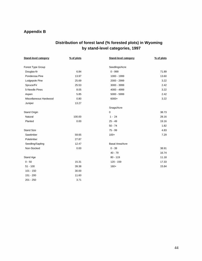
(Appendix A). Appendix B provides break-
downs of percent of forested plots sampled
based on these standard FHM stand-level
categories: forest type group, stand origin,
stand size, stand age, seedlings per acre, snags
per acre, and basal area per acre. FHM
sampled 68 field locations in Wyoming that
were either fully or partially forested. A small
percentage of plots straddled more than one
forest type; hence, there are more forest types
recorded (70) than there are total plots. Table
1 presents a summary of major FHM plot
forest types by ecoregion. Seventy-five per-
cent of plots fell in the Southern Rockies
ecoregion, and no spruce-fir or aspen plots
were sampled outside this province. No forest
types occur in all ecoregions of Wyoming.
Number of Sample Trees
Lodgepole PineSubalpine Fir
Englemann SpruceDouglas-fir
Ponderosa PineLimber PineUtah Juniper
Rocky Mtn. JuniperQuaking AspenWhitebark Pine
Paper BirchRocky Mtn. Maple
0 100 200 300 400 500 600
Live Trees Standing Dead Trees
22
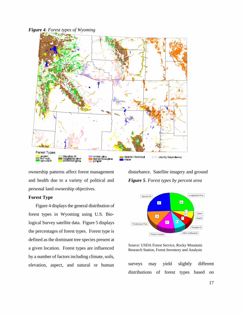
Figure 7 describes the number of overstory trees tallied by species, and whether trees were
Figure 8. Regeneration sampled in Wyoming
*Saplings have diameters between 1.0 inches and 5.0 inches at breast height or root collar. Seedlings are less than 1.0 inches breast height or root collar and exceed 1.0 foot in height.
alive or dead. There is a rough correlation
between those species most commonly tallied
and the prominent forest types in the state
(figure 5). For example, lodgepole pine is the
most common forest type displayed in figure 5
and this species was also the most commonly
sampled tree as illustrated in figure 7. This
correlation falls short with other species
because they may be commonly tallied within
other forest types. There are more spruce and
subalpine fir tallied statewide than the forest
type mapping (satellite imagery) suggests.
Many dead lodgepole pine were sampled from
burned trees still standing from the 1988
Yellowstone National Park fires and this
accounts for the high ratio of dead-to-live
lodgepole pines.
Figure 8 tallies understory species
specifically showing the number of understory
seedlings and saplings sampled by species. As
with the most common tallied tree, the most
seedlings tallied were lodgepole pine. These
numbers relate to the huge amount of
regeneration of lodgepole pine after the 1988
Yellowstone National Park fires. Subalpine fir
and aspen also produced abundant
regeneration numbers. The majority of these
seedlings either do not survive to reach full
tree size or mature in very dense stands, rarely
growing beyond five to seven inches in
diameter. Initial densities of these species will
be substantially reduced due to limited light
and water. Bur oak, Douglas-fir, and Rocky
mountain juniper are the only species sampled
Number of Sample Trees
Lodgepole PineSubalpine Fir
AspenLimber Pine
Englemann SprucePonderosa PineWhitebark Pine
Rocky Mtn. JuniperUtah Juniper
Douglas-firRocly Mtn. Maple
Bur Oak
0 50 100 150 200 250 300 350 400
Saplings Seedlings

23
showing saplings outnumbering seedlings. The
ratio of seedlings to saplings in ponderosa pine
is quite different. The regeneration of
ponderosa pine is more evenly split between
seedlings and saplings, suggesting greater
survival from seedling to maturity.
Appendix C is a complete list of analytical
variables measured on FHM plots. Variables
measured include tree diameter, height,
damages, seedling counts, soil texture, ozone
bioindicators, and lichen species present.
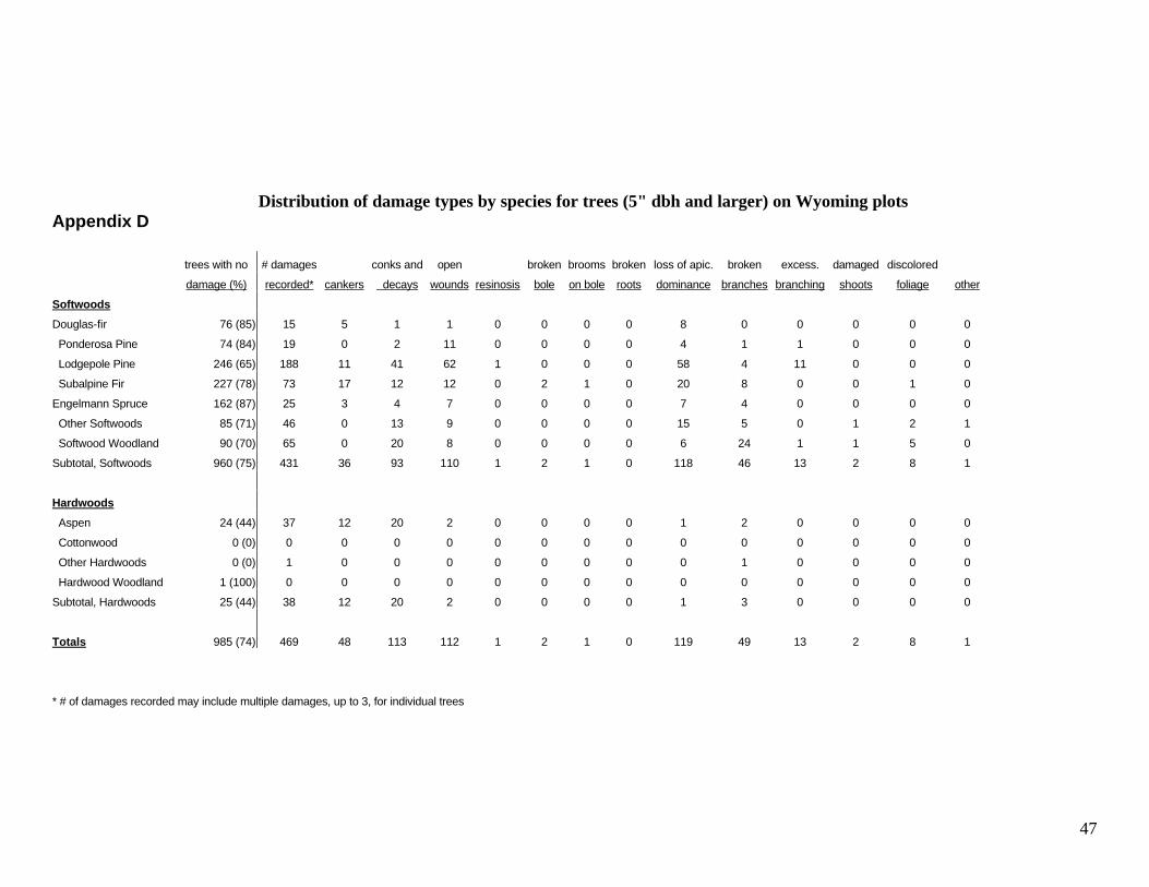
Appendix D provides a complete tally of
all tree damage measured on FHM plots by
damage type. There is also a column showing
the percentage of trees, by species, with no
significant damage.
Appendix E addresses crown condition.
Visual crown assessments are made to
determine changes in crown conditions
resulting from a variety of causal agents.
Estimates of crown dieback, foliage
transparency, and crown density were taken on
field plots for all live trees greater than five
inches diameter-at-breast-height to document
crown health. Results show little impact on
crown conditions statewide. However, long-
term tracking of plots will provide a better
understanding of how crown health reacts to
changing conditions in the atmosphere and on
the ground.
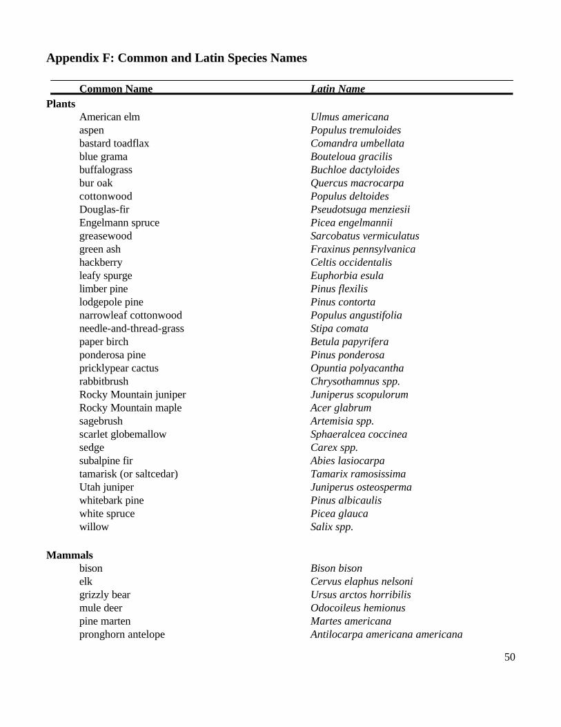
Appendix F lists the common and Latin
species names of plants, animals, insects and
diseases described in this report.
Considering land ownerships, forest types,
ecoregions, and the initial plot and tree
summary data, the variety and complexity of
Wyoming’s forests are evident. The forest
resource, as presented thus far, is really a static
view of the forested landscape of the state.
However, we know that conditions change,
sometimes rapidly, often gradually, based on
many factors. Forest health issues described in
the body of this report examine agents of
change, whether human or natural, in the
various forests of Wyoming.
24
Forest Health Issues
The forest health issues discussed throughout this report validate the dynamic nature of
Wyoming’s forests. Data came from many sources including aerial and ground surveys by state and
federal scientists, and studies conducted by university and federal researchers. This section

25
addresses forest health issues that are currently
of primary concern in Wyoming. Forest cover
changes in Wyoming are initially explained by
three topics: (1) White pine blister rust
incidence and severity, (2) riparian forest
health, and (3) aspen decline. Next is a
discussion of the primary insects and diseases
that are significant in Wyoming’s forests. Air
quality information is the next topic, where
emphasis is placed on tree crown evaluations,
lichen sampling, and ozone bioindicators.
Biodiversity, Wyoming’s urban forests, and
the expanding rural-urban-wildland interface
are discussed last.
Forest Cover Change
FHM is designed to assess forest cover
change by documenting species composition,
forest structure, and disturbance agents. This
is done by tracking the species makeup as well
as size, age, and relative dominance of all trees
on a particular site. FHM describes the
condition of individual trees by assessing
growth, mortality, regeneration, damage, and
estimates of crown conditions.
Forest cover change is commonly
attributed to wildfire suppression, termination
of traditional Native American burning
practices, forest succession, flood control, and
livestock grazing. Related disturbance cycles
and introduction of exotic species, such as
white pine blister rust and tamarisk, work in
tandem with human disruptions to affect large-
scale species change. Shifts in forest cover
take place over a period of decades, or even
centuries, and may not be readily observed by
casual forest visitors. None-theless, cover
changes have far-reaching effects on a forest's
susceptibility to fire, insects, disease, soil
erosion, and water evaporation and retention.
Forest cover changes in Wyoming include loss
of five-needled limber and whitebark pines,
conversion of riparian forests by invasive
species, and a decline in aspen.
White pine blister rust
White pine blister rust is an exotic disease
introduced to western North America at
Vancouver Island, Canada in 1910. The host
species for this disease are all five-needled
pines. Whitebark and limber pines are the
species affected in Wyoming. The disease can
kill both young and mature trees although
younger trees are usually killed quicker. White
pine blister rust coupled with mountain pine
beetle recently produced extensive mortality in
forests in northern Idaho and western Montana
(Kendall and Arno 1990, Keane et al. 1994).
High mortality from white

26
Figure 9. White pine blister rust: incidence and severity
Rust on >25% of host trees (topkill & mortality) Rust on 5% to 25% of host trees Rust on <5% of host trees
No rust observed County boundary
pine blister rust has not yet developed in
Wyoming.
Whitebark and limber pines are of little
economic value but have considerable
importance ecologically. Whitebark pine seed
is an important food source for Clark's nut-
cracker, grizzly bears, and red squirrels in the
Greater Yellowstone Area (Kendall and Arno
1990). These animals also serve as primary
agents of regeneration by dispersing seeds
through their consumption and excretion,
often miles from the seed source. Whitebark
and limber pines have differing water relations
than associated species such as subalpine fir
and Engelmann spruce. These differences
affect the amount of water produced from a
watershed (Moore and McCaughey 1997).
Both whitebark and limber pine grow in high
elevation areas that are common in wilder-
ness, parks, and other areas sought for public
recreation. Whitebark pine has a striking
aesthetic appearance and its loss could affect
recreational experiences (McCool and
Freidmund 2000).
Figure 9 displays survey results assessing
the amount and distribution of white pine
blister rust. The disease is present at most
white pine locations in western Wyoming,
although this incidence is not enough to be
detected by FHM plots currently. Smith and
Hoffman (1998) found the disease had only
moved 30 miles south over a 30-year period in
western Wyoming but the intensity and
severity of infections had increased. The
cooler and drier climates in Wyoming
compared to the west coast and the northern
Rockies seem to result in a slower rate of
spread. Knowledge of spread rates and

27
implications for managing these pines in
eastern Wyoming is unclear and needs further
investigation. Research on whitebark pine has
shown some natural resistance where rust
pressure has been high (Hoff et al. 2000). This
provides some hope for maintaining this
species and its role in high elevation
ecosystems.
Whitebark pine has also been experiencing
decline due to advanced succession of shade-
tolerant species (Keane and Arno 1993).
Whitebark pine has a unique set of ecological
functions and reproductive strategies, but the
lack of fire in this region, sometimes working
in concert with white pine blister rust, is the
predominant reason for the decline of this
species.
Riparian forest health
Riparian forests are important ecologically
and play significant roles in human conditions.
Rivers, intermittent streams, ponds, and
associated vegetation are critical to the
survival of most animals due to Wyoming’s
arid climate. Most animals rely on riparian
areas for water, food, and cover. The woody
vegetation provides nesting habitat for cavity-
nesting birds and bald eagles and foraging
habitat for deer, moose, raccoons, birds, and
many smaller mammals. Because of the
greater moisture in riparian areas, riparian
forests support a greater diversity of life than
the surrounding uplands. Riparian areas also
influence where cities are built and where
humans choose to recreate. The condition of
the riparian vegetation along watercourses
influences the water clarity, water volume,
temperature, speed, and depth of the water
course. These qualities in turn influence
drinking water quality, fish habitat, and flood
severity.
By examining data from various state and
federal sources on river systems throughout
Wyoming, a general picture of riparian forest
health can be formed. A big concern in the
Bighorn basin is the proliferation of tamarisk
and Russian olive along waterways (Walford
1996). These exotics are replacing native
willows and cottonwoods along most of the
watercourses in the basin. As a result, these
habitats do not support the same diversity of
wildlife as native vegetation. Other riparian
areas show large gradual changes in tree age
classes due to changes in water flow where
very few cottonwoods younger than 50 years
can be found (Jones and Walford 1995). If
regeneration continues to be a problem, these
areas will slowly become nonforested and
plant and animal communities associated with

28
these forests will change.
Working with other agencies and
organizations, FHM may illuminate and clarify
the condition of riparian forests. However,
riparian forests are under-sampled by the
current FHM grid largely because of their
linear nature. Improved sampling methods are
being evaluated to improve our understanding
of riparian forest dynamics. By gathering data
on tree size, tree condition, presence of exotic
species, lichen diversity and other indicators,
FHM can help alert land managers to the
changing conditions of riparian forests.
Aspen decline
Aspen cover throughout the Interior West
appears to be declining (Brown 1995, Bartos
and Campbell 1998, Rogers et al. 1998,
Rogers 2001). Aspen, the predominant hard-
wood of this region, supports a unique range
of understory plants and lichens which would
likely decline with the change in overstory.
Aspen also reproduces abundantly and rapidly
after fire. Aspen regenerate primarily by
suckering from underground rootstock. An
exception to regeneration by suckering has
been documented in Yellowstone National
Park where seeding was prompted by large-
scale burns during the summer of 1988
(Romme et al. 1997). Although 1988 was an
exceptional fire year, over the past 150 years a
reduction in widespread burning has led to a
significant drop in aspen regeneration in
Wyoming and regionally. Moreover, when no
disturbance takes place, older aspen (80 to150
years) are eventually replaced by competing
conifers. A preliminary look at FHM data
regionally, including Wyoming plots, shows
that the average age of aspen forest types is 68
years, while the average age of non-aspen
forest type stands (with aspen present) is 89
years. Finally, older aspen stands are more
susceptible to cankers, conks, and decays in
the bole. Over half of all aspen trees recorded
on FHM plots were damaged (Appendix D)
further speeding the decline of aging stands.
Long-term FHM data sets will provide a
reliable source for monitoring tree cover
changes over time. FHM will evaluate these
species fluctuations as forest plots are
remeasured and aerial survey data is gathered.
Insects and Diseases
Forest insects and diseases are a natural
part of forests and are partially responsible for
forest renewal. Most insects and diseases are
native, evolved with their hosts, and are
considered essential components of a healthy
forest. They play roles as decomposers and
nutrient recyclers, serving to continuously
29
rejuvenate forest soils. Insect and disease
activity is often interpreted as harmful when
they alter human expectations of the forest.
This happens when insect and disease activity
reaches noticeable levels in areas of high
economic or aesthetic value. Determining
when insect and disease incidences are beyond
a normal or healthy range can be difficult.
However, long-term monitoring will help
calibrate these disturbance events over time.
Insect and disease activity in Wyoming is
detected through aerial and ground surveys.
Aerial detection maps are produced annually
by state and federal surveyors and are used as
a management tool by landowners. The
following insects and diseases have been
contributing to large-scale tree decline and
mortality over the last three to seven years.
Dwarf mistletoes
Dwarf mistletoe is a parasitic seed plant
and is common in Wyoming's pine stands,
particularly lodgepole pine. Different species
of dwarf mistletoe infect ponderosa pine,
lodgepole pine, and Douglas-fir. Lodgepole
pine dwarf mistletoe occurs in 30 to 64 per-
cent of the stands in the three national forests
east of the Continental Divide (Johnson et al.
1978; Johnson et al. 1979). West of the
Continental Divide, dwarf mistletoe infected
67 percent of lodgepole pine and 17 percent of
Douglas-fir (Hoffman and Hobbs 1979).
Dwarf mistletoes can cause growth loss
and reduced vigor in trees rendering them
more susceptible to other mortality agents.
Mortality in stands with dwarf mistletoe can
increase the amount of down woody debris,
contributing to wildfire hazard. Dwarf mistle-
toes are also beneficial to many wildlife
species. The brooms and down wood provide
shelter and food for many bird, mammal,
insect, and arachnid species (Hawksworth and
Wiens 1996).
Comandra Blister Rust
Comandra blister rust is one of the most
destructive diseases of lodgepole pine in
Wyoming. Comandra blister rust is a native
rust fungus that requires two different hosts to
complete its life cycle: bastard toadflax and
hard pines such as lodgepole and ponderosa
(McMillin et al. 2000). This rust fungus
frequently occurs in dwarf mistletoe infected
stands although it is unknown if either disease
makes trees more susceptible to infection by
the other. Comandra blister rust produces
girdling cankers on stems of pine trees and
results in top killed stems. Large amounts of
deadfall from infected trees increase fuel
loading and potential for wildfire in these

30
stands.
Recent ground surveys conducted on the
Bighorn, Medicine Bow, and Shoshone
National Forests indicate that half of the basal
area of lodgepole pine is infected. In addition,
85 percent of these trees had dead tops, so this
disease often causes a "thinning from above."
The rust may delay or even prevent tree
maturation.
Douglas-fir Beetle
Douglas-fir beetle infests and kills
Douglas-fir throughout its range in Wyoming.
Typically, the beetle reproduces in scattered
trees that are highly stressed from drought,
fire, root rot, defoliation from western spruce
budworm, or windfall. If enough suitable host
material is present, beetles can build up in
these trees and move to infest nearby green
trees. For example, the 1988 Yellowstone
National Park fires burned onto neighboring
national forest lands killing and scorching a
large number of trees. Douglas-fir beetle
populations expanded in these scorched trees
and began attacking neighboring green trees.
Since these fires, populations of the beetle in
this area have been extremely high, with high
levels of tree mortality occurring nearly every
year. Beetle-caused mortality decreased in
1997 in the Sunlight Basin area, but has since
increased in this area and along the North Fork
of the Shoshone River. Between 1998 and
1999, tree mortality increased from 1,680 trees
killed by Douglas-fir beetle on 2,383 acres to
14,450 trees killed on 5,791 acres (Johnson
and McMillin 2000). Periodic infestations of
Douglas-fir beetle have been documented in
the Bighorn Mountains.
Mountain pine beetle
Mountain pine beetle is a native bark beetle
that attacks and kills lodgepole, ponderosa,
whitebark, and limber pines in Wyoming.
Currently, mountain pine beetle populations
are increasing along the eastern slope of the
Bighorn Mountains and along the Snake River
in the Bridger-Teton National Forest.
Subalpine fir decline
Currently there is widespread subalpine fir
decline occurring throughout the Rocky
Mountains of Wyoming. Large areas of sub-
alpine fir mortality have been observed on the
Bighorn, Shoshone, Bridger-Teton, and
Medicine Bow National Forests during recent
aerial surveys. The exact causes have not been
defined, but western balsam bark beetle, fir
engraver beetle, and Armillaria and Annosus
root diseases are known to play a role in this
phenomenon. Western balsam bark beetle is
known to cause tree mortality in other western

31
states. Armillaria root rots generally weaken
hosts, increasing their susceptibility to insects,
windthrow, and other diseases. Many of the
stands affected by this decline are very dense.
Because western balsam bark beetle,
Armillaria, and Annosus are not often
aggressive killers, they may be acting as
natural thinning agents in over-crowded
stands.
Air Quality
The Forest Health Monitoring program
originated largely from a reaction to the mid-
1980's concern about the effects of industrial
pollution, or "acid rain," on the forests of
eastern North America and Europe (Burkman
and Hertel 1992). Tree crown evaluations,
damage detection, lichen sampling, and ozone
biomonitoring may be applied to air quality
analysis. Lichen sampling and ozone bio-
monitoring link pollutants to forest health
although symptoms of air quality change may
show up in both crown and damage data.
Ozone biomonitoring involves locating
ozone sensitive plant species and assessing
their damage specifically from atmospheric
ozone. Atmospheric ozone is a chemical
pollutant hazardous to the earth's biosphere.
This “manufactured" ozone results primarily
from excessive automotive exhaust, mostly
near large urban areas. Stratospheric ozone is
natural, protecting the earth from the sun’s
ultraviolet rays. Ozone damage to forests has
been documented in southern California for
decades (Miller and Millican 1971). In
Wyoming, FHM field crews have located
potentially sensitive plants near most plots to
assess long-term change. Thus far, no damage
from atmospheric ozone has been detected in
the state.
Numerous studies have documented the
relationship between air quality and lichen
communities in forested areas (McCune 1997).
Lichens utilize nutrients in the air to sustain
themselves and to regenerate. Poor air quality
leads to a loss of some sensitive species and an
increase in species tolerant of
certain chemical pollutants. Field crews
sample the diversity of species at each forested
location. Statewide monitoring of lichen
species and their abundance on plots permits
early detection of pollution effects. Preliminary
analysis of Wyoming lichen data has recently
been completed (Neitlich et al. 1999). Initial
results are tentative since a gradient model for
the state has not been developed, and no trend
information is available to evaluate changes
over time. Nevertheless, data does indicate a
depression

32
of lichen species diversity in the southern
portion of the state and a preliminary gradient
analysis shows a greater relative abundance of
pollution-tolerant species. This information is
consistent with FHM information reported for
areas around Steamboat Springs and Denver,
Colorado (McCune 1997).
Other sources of information may be
available for localized areas in Wyoming. St.
Clair (1993) sampled lichens in the Bridger
Wilderness for species abundance and
chemical properties. Results showed floristic
diversity with no visual signs of pollution
sensitive species. The chemical analysis
indicated elevated levels of lead, zinc, and
manganese. These levels were above
concentrations for most of the Rocky
Mountain region although quite low compared
to more heavily polluted areas.
The real value of all of these baseline
measurements, both local and statewide, will
be a long-term effort to consistently assess the
effects of atmospheric pollutants on forest
communities. Today's data will give us a
benchmark to assess future changes.
Biodiversity
Biodiversity is a measure of the variety of
living organisms in a particular area and serves
33
as an important indicator of ecosystem
function. Recent reports suggest there is a
decrease both regionally and nationally in
diversity (Langner and Flather 1994). FHM is
designed to monitor change in biotic diversity
over time as an indicator of ecosystem health.
Sustained healthy habitats for plants and
animals are an important measure of all living
communities, including forests. Forests that
are structurally and floristically diverse appear
more resilient to natural and human-related
disturbances, such as fires, windstorms, insect
and disease infestations, and logging related
impacts (Stapanian et al. 1997).
Diversity is commonly measured at
genetic, species, and community levels. FHM
is most concerned with community diversity,
though the underlying importance of species
and genetic diversity is recognized. There is
considerable diversity in Wyoming but the
effects of human activity and changes over
time on diversity are not well understood. A
brief look at forest fragmentation and exotics
will offer some explanation.
Forest fragmentation is a measure of forest
health affecting community diversity.
Fragmented forests display a greater number
of landscape "patches." Increased forest
fragmentation results in shrinking patch sizes,
which negatively affects interior-dwelling
wildlife species. Increased fragmentation also
results in an increase in forest-edge habitat
favoring some species, such as deer and elk. A
recent study done in southeastern Wyoming
suggests that road building may have a greater
overall impact on forest fragmentation than
clearcut logging (Reed et al. 1996).
Introduction of exotic species into Interior
West ecosystems also seems to be affecting
biodiversity over time. Whether introductions
are accidental or intentional, exotic species of
plants, animals, and diseases are spreading
rapidly through many forests in Wyoming.
There are many exotic plants invading forested
and adjacent non-forested zones. Human
travel and livestock grazing are two key
factors contributing to exotic plant invasions.
The dominance of leafy spurge over much of
the rangeland in the state is slowly succumbing
to the work of several introduced biological
control agents. But just as it has taken
decades for leafy spurge to become so
dominant, so it is taking decades to reclaim the
rangeland with native grasses.
FHM will assess human impacts on
biodiversity by utilizing systematic plot
measurements in combination with pertinent
studies conducted by others. As part of our

34
current protocol, field crews note recent
natural and human disturbances in sample
areas. Documentation of plot disturbances can
be classified and compared to the number and
type of plant species found on plots as an
indicator of human effects on species diversity
(Stapanian et al. 1997). FHM will use soil
sampling and erosion data, in part, to
document how recent disturbance has affected
basic soil properties. Significant soil alter-
ation can affect the types and richness of
communities that can be supported.
Urban Forests
Urban forests have a profound effect on
our quality of life. Trees in cities moderate
wind, heat, cold, and other weather effects and
beautify the areas we see everyday.
Wyoming's urban forests are particularly
important because they represent the only
forests in some areas. Because each urban
tree provides a variety of benefits, these trees
are very valuable. The 108,000 public trees
recently inventoried in 37 communities in
Wyoming have an estimated value of
$115,313,827 (Wyoming State Forestry
Division 1991-1996). Monitoring the health
of urban forests provides a measure of the
health of the environment most Americans
inhabit. Monitoring enables managers to
prevent catastrophic tree problems.
Thousands of community trees, now
reaching maturity, were planted during the
development of Wyoming’s cities and towns
(Wyoming State Forestry Division 1991).
Wyoming’s high elevation, arid climate, and
persistent wind present formidable challenges
in urban forestry establishment and
maintenance. Wyoming’s urban forests lack
the diversity to resist weather and pest
impacts. Nearly one in five street trees are
cottonwoods while just three species (cotton-
wood, blue spruce, and green ash) comprise
44 percent of street trees in Wyoming
(Wyoming State Forestry Division 1991-
1996). Any natural disaster or insect or
disease problem targeting any of these three
species would have a devastating impact on
most Wyoming towns. Long-term monitoring
of urban forest species, age diversity, and the
presence of insects and pathogens can yield
early indications of potential problems.
Although urban forests are not sampled in the
current FHM program, sampling methods to
address urban areas are currently being
evaluated.
Rural-Urban-Wildland Interface
The rural-urban-wildland interface
represents rural and urban areas where

35
Figure 10. Percent change in population for Wyoming counties: 1990 to 2000 % change
-6.1 – 1.9
4.0 – 9.0
11.0 – 13.0
14.0 – 64.0
Source: Wyoming Department of Administration and Information, Division of Economic Analysis
structures or other human developments meet
or intermingle with undeveloped wildland or
vegetative fuels. In recent decades, Wyoming
has seen an increase in development in and
near forested lands. Data from the 1990
Census and subsequent updates conducted by
the U.S. Census Bureau indicate the state
population is increasing. As figure 10
illustrates, most counties showing population
increases are those containing or adjoining
National Forests and National Parks. This is
particularly evident in western Wyoming
where the three fastest growing counties are
located. The Bridger-Teton and Shoshone
National Forests as well as the Grand Teton
and Yellowstone National Parks are located in
this area.
People are relocating for a variety of
reasons including employment opportunities,
building larger homes, and the availability of
open space and recreation. Growth in the
rural-urban-wildland interface affects the
diversity, beauty, and health of the surrounding
landscape and will undoubtedly provide
considerable challenges in the future.

37
Summary
Forest Health Monitoring began in
Wyoming in 1995. Every five years, a
complete remeasurement cycle will be
completed. This report provides the first
snapshot of forest conditions as measured by
the same set of indicators in all types of forests
statewide. Long-term data collection will
provide a series of these snapshots. A
comparison of these snapshots will provide an
indication of forest condition trends. As data
gathering continues, much will be learned
about how these forests function and how they
change.
Current monitoring reveals several changes
occurring in Wyoming’s forests. Limber pine,
whitebark pine, cottonwood, aspen, and
subalpine fir appear to be declining due to one
or more of the following reasons: changes in
fire frequency, changes in water use, exotic
diseases, and competition from exotic plants.
Road building may be impacting the biological
diversity of many forests. Lack of tree-species
diversity in Wyoming’s urban forests puts
them at risk
38
from a single insect or disease.
This report utilizes many sources of
information in an attempt to present an over-
view of Wyoming forest health. Sources
include FHM plot data, aerial and ground
surveys by State and federal foresters, and
studies conducted by university and federal
researchers. A state synopsis of current issues
is available on the internet in the Forest Health
Highlights at the US Forest Service’s National
Forest Health Monitoring home page:
http://www.na.fs.fed.us/spfo/fhm. For more
information, access to data, or for answers to
specific questions, see Appendix G for a
complete list of contacts.

39
References
Anonymous. 1995. Sustaining the World's forests: The Santiago Agreement. J. of Forestry 93:18-21. Bailey, R.G. 1995. Descriptions of the ecoregions of the United States. (2nd ed. rev. and expanded). USDA Forest Service, Washington, DC. Misc. Publ. No. 1391. Bartos, D. and R. Campbell. 1998. Decline of quaking aspen in the Interior West - examples from Utah. Rangelands 20(1):17-24. Brown, M. 1995. Aspen decline in the inland Northwest: a review of some relevant literature. Unpublished report. Copies filed at: USDA Forest Service, Pacific Northwest Research Station and the Smithsonian Institution. Burkman, W. and G. Hertel. 1992. Forest Health Monitoring: a national program to detect, evaluate, and understand change. J. of Forestry 90(9):26-27. Forest Inventory and Analysis National Core Field Guide. February 2000. Volume 1: Field Data Collection Procedures For Phase 2 Plots – Version 1.4. USDA Forest Service. 172 p. Green, A.W. and R.C. Conner. 1989. Forests in Wyoming. Resource Bulletin INT-61. USDA Forest Service, Intermountain Research Station, Ogden, Utah. 91 p. Hawksworth, F.G. and D. Wiens. 1996. Dwarf Mistletoes: Biology, pathology, and systematics. USDA Forest Service. Rocky Mountain Forest and Range Experiment Station, Ft. Collins, CO. Agriculture Handbook 709. 410 p. Hoff, R. J., R. E. Keane, D. E. Ferguson, and G. I. McDonald. 2000 in preparation. Strategies for managing whitebark pine in the presence of white pine blister rust. "Restoring Whitebark Pine Ecosystems Proceedings September 9-12, 1998. Island Press. Hoffman, J.T. and L.G. Hobbs. 1979. Dwarf Mistletoe Loss Assessment Survey in Region 4, 1978. USDA Forest Service. State and Private Forestry, Ogden, Utah. R-4-79-4. Johnson, D.W., F.G. Hawksworth, and D.B. Drummond. 1978. 1977 Dwarf Mistletoe Loss Assessment Survey: Medicine Bow National Forest, Wyoming. USDA Forest Service. Forest Insect and Disease Management. Methods Application Group. Report 78-1. 6 p. Johnson, D.W., F.G. Hawksworth, and D.B. Drummond. 1979. 1978 Dwarf Mistletoe Loss Assessment Survey: Bighorn and Shoshone National Forests, Wyoming. USDA Forest Service. Forest Insect and Disease Management. Methods Application Group. Report 79-3. 8 p.

40
Johnson, E. and J. McMillin. 2000. Forest Health Monitoring Aerial Survey. Rocky Mountain Region. 3410 RCSC-00-03. Jones, G. P. and G. M. Walford. 1995. Major Riparian Vegetation Types of Eastern Wyoming - A report submitted to the Wyoming Department of Environmental Quality, Water Quality Division by Wyoming Natural Diversity Database (The Nature Conservancy) 1604 Grand Avenue, Laramie, Wyoming 82070. Grant #9-01136. Keane, R.E., P. Morgan, and J.P. Menakis. 1994. Landscape assessment of the decline of whitebark pine (Pinus albicaulis) in the Bob Marshall Wilderness Complex, Montana, USA. Northwest Science 68 (3):213-229.
Keane, R. and S. Arno. 1993. Rapid decline of whitebark pine in western Montana: evidence from 20-year remeasurements. Western Journal of Applied Forestry, Vol. 8, No. 2, p. 24-37. Kendall, K. and S. Arno. 1990. Whitebark pine: an important but endangered wildlife resource. In: Proceedings of the symposium: Whitebark pine ecosystems: ecology and management of a high mountain resource. March 29-31, 1989, Bozeman, Montana, USA. USDA Forest Service, Intermountain Research Station, Ogden, Utah, Gen. Tech. Rep. INT-270, p. 264-274. Knight, D. 1994. Mountains and Plains: the ecology of Wyoming landscapes. Yale University Press, New Haven and London. 338 p. Langner, L. and C. Flather. 1994. Biological diversity: status and trends in the United States. Gen. Tech. Report RM-244. USDA, Forest Service, Rocky Mountain Forest and Range Experiment Station, Fort Collins, Colorado. 24 p.
McCool, S.F. and Freidmund, W. 2000. The diminished landscape: aesthetic and recreational consequences: Restoring Whitebark Pine Ecosystems Proceedings, September 9-12, 1998. Island Press. McCune, B. 1997. FHM Lichen Community Results from Colorado: a Preliminary Summary. Oregon State University. Corvallis, OR. 43 p. McMillin, J., J. Harris, and K. Allen. 2000. Insect and Disease Survey of the Bighorn National Forest. Biological Evaluation R2-00-04. 27 p. Miller, P. and Millican, A. 1971. Extent of oxidant air pollution damage to some pines and other conifers in California. Plant Disease Reporter 55(6):555. Moore, C.A. and W. W. McCaughey. 1997. Snow accumulation under various forest stand densities at Tenderfoot Creek Experimental Forest, Montana, USA. 66th Western Snow Conference, May 5-8, 1997, Banff, Alberta, Canada.

41
Neitlich, P., Hasselback, L., Szewczak, S., and Rogers, P. 1999. FHM lichen community results from Wyoming, 1997: a preliminary summary. A report to the USDA Forest Service, Rocky Mountain Research Station, Forest Health Monitoring Program. White Mountain Research Station, Bishop, CA. 27 p. Reed, R., J. Johnson-Barnard, and W. Baker. 1996. Contribution of Roads to Forest Fragmentation in the Rocky Mountains. Conservation Biology 10(4):1098-1106. Rogers, P., M. Schomaker, W. McLain, and S. Johnson. 1998. Colorado Forest Health Report 1992-95: a baseline assessment. USDA Forest Service, Rocky Mountain Research Station and Rocky Mountain Region; and Colorado State Forest Service. 44 p. Rogers, P. 2001. Using forest health monitoring to assess aspen forest cover change in the Southern Rockies ecoregion. Forest ecology and management (in press). Romme, W., M. Turner, R. Gardner, W. Hargrove, G. Tuskan, D. Despain, and R. Renkin. 1997. A rare episode of sexual reproduction in aspen (Populus tremuloides Michx.) following the 1988 Yellowstone fires. Natural Areas Journal 17:17-25. St. Clair, L.L. and Newberry, C.C. 1993. Lichen Biomonitoring Program and Air Quality Baseline in Selected Sites of the Bridger Wilderness Area, Bridger-Teton National Forest. Final Report. Bridger-Teton N.F. 52 p. Smith, J. and J. Hoffman. 1998. Status of white pine blister rust in intermountain region white pines. Intermountain Region, State and Private Forestry Report No. 98-02. 24 p. Stapanian, M., D. Cassell, and S. Cline. 1997. Regional patterns of local diversity of trees: associations with anthropogenic disturbance. Forest Ecology and Management 93(1-2):33-44. Stolte, K. 1997. National Technical Report on Forest Health. USDA Forest Service, Asheville, North Carolina. Administrative Report. Walford, G.M. 1996. Statewide Classification of Riparian and Wetland Dominance Types and Plant Communities - Bighorn Basin Segment. A report submitted to the Wyoming Department of Environmental Quality, Water Quality Division by Wyoming Natural Diversity Database (The Nature Conservancy) 1604 Grand Avenue, Laramie, Wyoming 82070. Cooperative Agreement #WET04, Grant #CD998066-01-0. Wyoming State Forestry Division, Statewide Urban Forest Inventories 1991-1996, Cheyenne, WY. Wyoming State Forestry Division. 1991. Wyoming State Forest Resource Program 1999-2000, Executive Summary. Cheyenne, WY.

43
Appendix A Plot Distribution in the Interior West by State and Land Use (totals are in fractions of plots) Land Use Category Region totals Wyoming totals Colorado totals Idaho totals
Timberland 271.66 53.89 93.79 123.98
Woodland 58.38 8.25 41.85 8.28
Inaccessible Forest 23.00 6.25 11.75 5.00
Non-Forest 778.96 324.61 266.61 187.74
Totals 1132.00 393.00 414.00 325.00
44
Appendix B
Distribution of forest land (% forested plots) in Wyoming by stand-level categories, 1997 Stand-level category % of plots Stand-level category % of plots
Forest Type Group Seedlings/Acre
Douglas-fir 6.84 0 - 999 71.89
Ponderosa Pine 13.97 1000 - 1999 13.60
Lodgepole Pine 25.69 2000 - 2999 3.22
Spruce/Fir 25.53 3000 - 3999 2.42
5-Needle Pines 8.05 4000 - 4999 3.22
Aspen 5.85 5000 - 5999 2.42
Miscellaneous Hardwood 0.80 6000+ 3.22
Juniper 13.27 Snags/Acre
Stand Origin 0 38.73
Natural 100.00 1 - 24 28.16
Planted 0.00 25 - 49 19.16
50 - 74 1.82
Stand Size 75 - 99 4.83
Sawtimber 59.65 100+ 7.29
Poletimber 27.87
Seedling/Sapling 12.47 Basal Area/Acre
Non-Stocked 0.00 0 - 39 38.91
40 - 79 16.74
Stand Age 80 - 119 11.18
0 - 50 15.31 120 - 159 17.33
51 - 100 39.38 160+ 15.84
101 - 150 30.00 151 - 200 11.60 201 - 250 3.71

45
Appendix C
List of analytical variables from FHM plots
Variable name Data type* Variable name Data type* MENSURATION, CROWNS, DAMAGE Plot level
County number code Current plot status code Elevation num. FHM region code Hexagon (location number ) num. Measurement type code Overlap code Old plot status code Panel code Quality assurance status code Plot mensuration year num. Plot number num. Plot status code Plot type code Project code State code
Condition level
Condition class num. Condition class change code Density check code Disturbance year 1 num. Disturbance year 2 num. Disturbance year 3 num. Forest type code Land Use class code Past disturbance 1 code Past disturbance 2 code Past disturbance 3 code Previous stand age num. Stand age num. Stand origin code Stand size code
Tree level (trees, saplings, site trees)
Basal area factor (site tree) num. Cause of death code Competing basal area num. Crown density num. Crown diameter (mean) num. Crown dieback num. Crown light exposure code Crown position code Crown vigor (saplings) code Current tree history code DBH(diameter breast height) num DRC (diameter root collar) num. Damage 1 - 3 code Description (tree notes) alpha. Foliage transparency num. Ground year num. Live crown ratio num. Location (damage) 1-3 code Mortality year num Nonforest year num. Old DBH num. Old DRC (woodland) num. Old stem count (woodland) num. Old tree history code Severity (damage) code Species code Stem count (woodland) num Tree age at DBH num. Tree height num.
Understory cover and seedlings
Crown light exposure code Crown position code Crown vigor code Percent Ferns num. Percent Herbs num. Percent Moss num. Percent seedlings num. Percent Shrubs num. Seedling count num. Species code
*Data types: num. = numeric value code = numeric code alpha. = letters or words

46
Appendix C (continued) Variable name Data type* Variable name Data type* SOILS (soil sampling, erosion)
A texture code A thickness (N,S,E,W) num. Depth to subsoil num. Litter decomposition alpha. Litter depth 1-3 num. O thickness (N,S,E,W) num. Percent bare (mineral) soil num. Percent litter cover num. Percent plant cover num. Slope length num. Underlying texture code
OZONE BIOINDICATORS
Amount of injury code Bio site availability code Bio site disturbance code Bio site status code First species code Number of plants 1-3 num. Plot moisture code Plot size code Second species code Severity of injury code Soil depth code Soil drainage code Third species code
LICHEN COMMUNITIES
Species alpha. Abundance code
*Data types: num. = numeric value code = numeric code alpha. = letters or words
47
Appendix D
Distribution of damage types by species for trees (5" dbh and larger) on Wyoming plots
trees with no # damages conks and open broken brooms broken loss of apic. broken excess. damaged discolored
damage (%) recorded* cankers decays wounds resinosis bole on bole roots dominance branches branching shoots foliage other
Softwoods
Douglas-fir 76 (85) 15 5 1 1 0 0 0 0 8 0 0 0 0 0
Ponderosa Pine 74 (84) 19 0 2 11 0 0 0 0 4 1 1 0 0 0
Lodgepole Pine 246 (65) 188 11 41 62 1 0 0 0 58 4 11 0 0 0
Subalpine Fir 227 (78) 73 17 12 12 0 2 1 0 20 8 0 0 1 0
Engelmann Spruce 162 (87) 25 3 4 7 0 0 0 0 7 4 0 0 0 0
Other Softwoods 85 (71) 46 0 13 9 0 0 0 0 15 5 0 1 2 1
Softwood Woodland 90 (70) 65 0 20 8 0 0 0 0 6 24 1 1 5 0
Subtotal, Softwoods 960 (75) 431 36 93 110 1 2 1 0 118 46 13 2 8 1
Hardwoods
Aspen 24 (44) 37 12 20 2 0 0 0 0 1 2 0 0 0 0
Cottonwood 0 (0) 0 0 0 0 0 0 0 0 0 0 0 0 0 0
Other Hardwoods 0 (0) 1 0 0 0 0 0 0 0 0 1 0 0 0 0
Hardwood Woodland 1 (100) 0 0 0 0 0 0 0 0 0 0 0 0 0 0
Subtotal, Hardwoods 25 (44) 38 12 20 2 0 0 0 0 1 3 0 0 0 0
Totals 985 (74) 469 48 113 112 1 2 1 0 119 49 13 2 8 1
* # of damages recorded may include multiple damages, up to 3, for individual trees

48
Appendix E
Visual Crown Ratings
Visual crown assessments are made to determine changes in crown conditions resulting from a
variety of causal agents. Estimates of crown dieback, transparency, and density were taken on field plots for all live trees greater than 5 inches d.b.h. in order to document crown health. Results of the baseline measures show that crowns have not been severely impacted statewide (facing page). However, long-term tracking of plots will give us a better reading of how crown health reacts to changing conditions in the atmosphere and on the ground. More detailed discussion of each crown variable is presented below.
CROWN DIEBACK Dieback is a measure of percent of the tree crown that has died from the branch tips inward, toward
the center of the crown. Crown dieback can be caused by insects, disease, and weather related injuries. The graph shows that most of the trees sampled in Wyoming have very little dieback. Hardwood and softwood ratings are nearly identical in terms of dieback. Future readings of dieback can be compared to current values to look for shifts in dieback among all trees, or by individual species.
FOLIAGE TRANSPARENCY Transparency is the percent of light that passes through the foliated portion of the crown, excluding
tree branches and main stems. A tree with a rating of "0" or "5" percent transparency allows either no light, or very little light, to pass through the leaves to the forest floor. In general, when trees are unhealthy their crowns begin to thin out, therefore allowing more light to pass through. The bar graph of foliage transparency, similar to crown dieback, is highly weighted to the lower percent values. This indicates that very few tally trees in Wyoming are thinning due to declining vigor.
CROWN DENSITY Crown density is determined by estimating the percent crown area that blocks light from passing
through. This rating does include woody parts of the tree, so this is not an exact complement of foliage transparency. Of particular concern in future readings will be movements away from the middle of this graph by any species or group. Currently, most trees are rated between 25-75 percent density. Low density crowns may signal declines in growth from a variety of causal agents, both atmospheric and nonatmospheric. Very dense trees may be unhealthy too. For example, many conifer species "broom up" initially as a result of mistletoe infection.

49
50
Appendix F: Common and Latin Species Names
Common Name Latin Name Plants
American elm Ulmus americana aspen Populus tremuloides bastard toadflax Comandra umbellata blue grama Bouteloua gracilis buffalograss Buchloe dactyloides bur oak Quercus macrocarpa cottonwood Populus deltoides Douglas-fir Pseudotsuga menziesii Engelmann spruce Picea engelmannii greasewood Sarcobatus vermiculatus green ash Fraxinus pennsylvanica hackberry Celtis occidentalis leafy spurge Euphorbia esula limber pine Pinus flexilis lodgepole pine Pinus contorta narrowleaf cottonwood Populus angustifolia needle-and-thread-grass Stipa comata paper birch Betula papyrifera ponderosa pine Pinus ponderosa pricklypear cactus Opuntia polyacantha rabbitbrush Chrysothamnus spp. Rocky Mountain juniper Juniperus scopulorum Rocky Mountain maple Acer glabrum sagebrush Artemisia spp. scarlet globemallow Sphaeralcea coccinea sedge Carex spp. subalpine fir Abies lasiocarpa tamarisk (or saltcedar) Tamarix ramosissima Utah juniper Juniperus osteosperma whitebark pine Pinus albicaulis white spruce Picea glauca willow Salix spp.
Mammals bison Bison bison elk Cervus elaphus nelsoni grizzly bear Ursus arctos horribilis mule deer Odocoileus hemionus pine marten Martes americana pronghorn antelope Antilocarpa americana americana

51
Appendix F (continued) Common Name Latin Name Mammals
red squirrel Tamiasciurus budsonicus white tail deer Odocoileus virginianus
Birds Clark's nutcracker Nucifraga columbiana Insects
Douglas-fir beetle Dendroctonus pseudotsugae fir engraver beetle Scolytus ventralis gypsy moth Lymantria dispar mountain pine beetle Dendroctonus ponderosae spruce beetle Dendroctonus rufipennis western balsam bark beetle Dryocoetes confusus western spruce budworm Choristoneura occidentalis
Diseases comandra blister rust Cronartium comandrae dwarf mistletoe Arceuthobium spp. white pine blister rust Cronartium ribicola

52
Appendix G Contacts for Further Information
Kenneth Stolte Thomas Ostermann Acting National Program Manager State Forester USDA Forest Service Wyoming State Forestry Division 201 14th Street, S.W. 1100 W. 22nd Street Washington, DC 20250 Cheyenne, WY 82002 (202)205-1308 (307)777-7586 [email protected] [email protected] David A. Anderson, Director William Boettcher, Director Forest Health Protection Forest Health Protection Rocky Mountain Region Intermountain and Northern Regions USDA Forest Service USDA Forest Service P.O. Box 25127 P.O Box 7669 Denver, CO 80225 Missoula, MT 59807 (303)275-5026 (406)329-3280 [email protected] [email protected] Dwane Van Hooser Interior West Program Manager Rocky Mountain Research Station USDA Forest Service 507 25th St. Ogden, UT 84401 (801)625-5388 [email protected] Forest Health Monitoring Web Sites:
National Program: http://www.na.fs.fed.us/spfo/fhm Regional, Forest Health Protection: http://www.fs.fed.us/r2/fhm Regional, Forest Inventory/Analysis: http://www.fs.fed.us/rm/ogden/index.html