Embed Size (px)
Citation preview
www.epa.gov/ord/erpECOLOGICAL RESEARCH PROGRAMB U I L D I N G A S C I E N T I F I C F O U N D A T I O N F O R S O U N D E N V I R O N M E N T A L D E C I S I O N S
U.S. Environmental Protection AgencyOffice of Research and Development
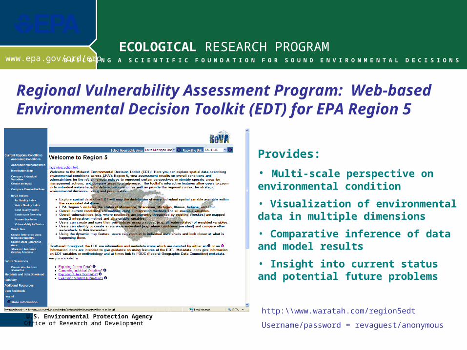
Provides:
• Multi-scale perspective on environmental condition
• Visualization of environmental data in multiple dimensions
• Comparative inference of data and model results
• Insight into current status and potential future problems
Regional Vulnerability Assessment Program: Web-based Environmental Decision Toolkit (EDT) for EPA Region 5
http:\\www.waratah.com/region5edt
Username/password = revaguest/anonymous
2
ECOLOGICAL RESEARCH PROGRAM
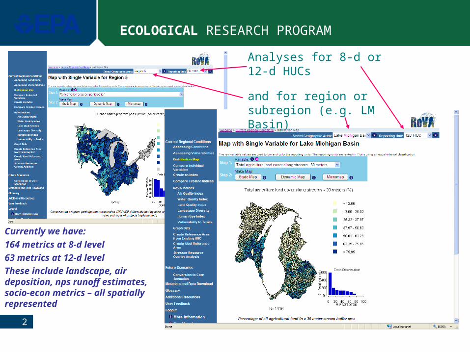
and for region or subregion (e.g. LM Basin)
Analyses for 8-d or 12-d HUCs
Currently we have:
164 metrics at 8-d level
63 metrics at 12-d level
These include landscape, air deposition, nps runoff estimates, socio-econ metrics – all spatially represented
3
ECOLOGICAL RESEARCH PROGRAM
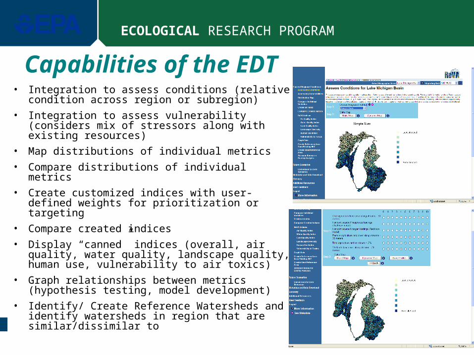
Capabilities of the EDT• Integration to assess conditions (relative
condition across region or subregion)
• Integration to assess vulnerability (considers mix of stressors along with existing resources)
• Map distributions of individual metrics
• Compare distributions of individual metrics
• Create customized indices with user-defined weights for prioritization or targeting
• Compare created indices
• Display “canned” indices (overall, air quality, water quality, landscape quality, human use, vulnerability to air toxics)
• Graph relationships between metrics (hypothesis testing, model development)
• Identify/ Create Reference Watersheds and identify watersheds in region that are similar/dissimilar to
4
ECOLOGICAL RESEARCH PROGRAM
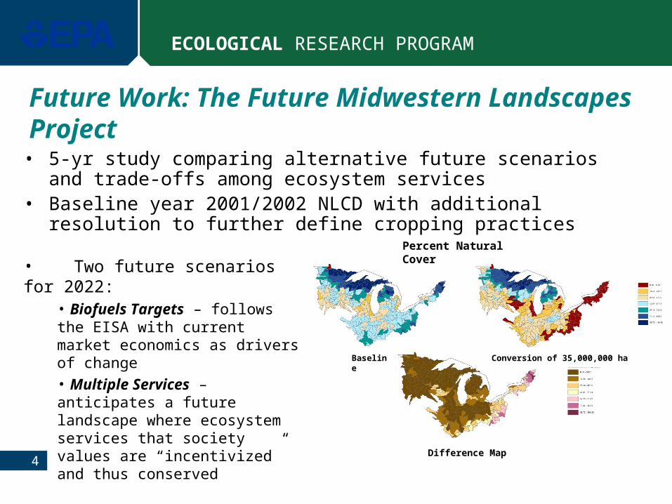
Future Work: The Future Midwestern Landscapes Project
• 5-yr study comparing alternative future scenarios and trade-offs among ecosystem services
• Baseline year 2001/2002 NLCD with additional resolution to further define cropping practices
Percent Natural Cover
Baseline Conversion of 35,000,000 ha
Difference Map
• Two future scenarios for 2022:• Biofuels Targets – follows the EISA with current market economics as drivers of change• Multiple Services – anticipates a future landscape where ecosystem services that society values are “incentivized” and thus conserved
5
ECOLOGICAL RESEARCH PROGRAM
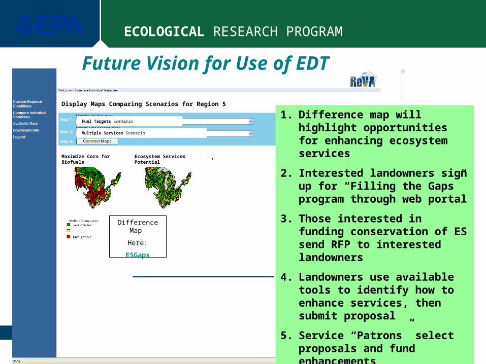
Fuel Targets Scenario
Multiple Services Scenario
Display Maps Comparing Scenarios for Region 5
Maximize Corn for Biofuels Ecosystem Services Potential
Difference Map
Here:
ESGaps
Future Vision for Use of EDT
1. Difference map will highlight opportunities for enhancing ecosystem services
2. Interested landowners sign up for “Filling the Gaps” program through web portal
3. Those interested in funding conservation of ES send RFP to interested landowners
4. Landowners use available tools to identify how to enhance services, then submit proposal
5. Service “Patrons” select proposals and fund enhancements
6
ECOLOGICAL RESEARCH PROGRAM
Ecosystem Services
Land ValuesRecreational ActivitiesAestheticsCultural ServicesBiodiversity Existence ValueHuman HealthFlood ControlClimate/Weather MitigationFood SecurityForest ProductsPotable WaterEnergy Security
Partners/Collaborators/Clients
Iowa State UniversityKansas State UniversityEPA Region 7EPA Office of WaterEPA Office of Air and RadiationAgricultural Research ServiceFarm Services AdministrationFish and Wildlife ServiceTennessee Valley AuthorityIowa Soybean AssociationAmerican Farmland TrustGLNPO – Lake Michigan
Some Additional Info
For more information: [email protected]