Embed Size (px)
Citation preview
Page 1 of 1
WWNWS WWNWS9/3/4/1.1
Meeting 9 11 August 2017
Agenda Item 3.4.1
Analysis and assessment of the GMDSS performance of Inmarsat Global Limited
Submitted by IHO Secretariat
1. See attached document.
2. The Sub-Committee is invited to note the information provided and take action as
appropriate.
SUMMARY
Executive Summary: This document contains the annual report to IMO by IMSO on
Inmarsat's obligations for the provision of maritime distress and safety services in the
GMDSS, as overseen by IMSO.
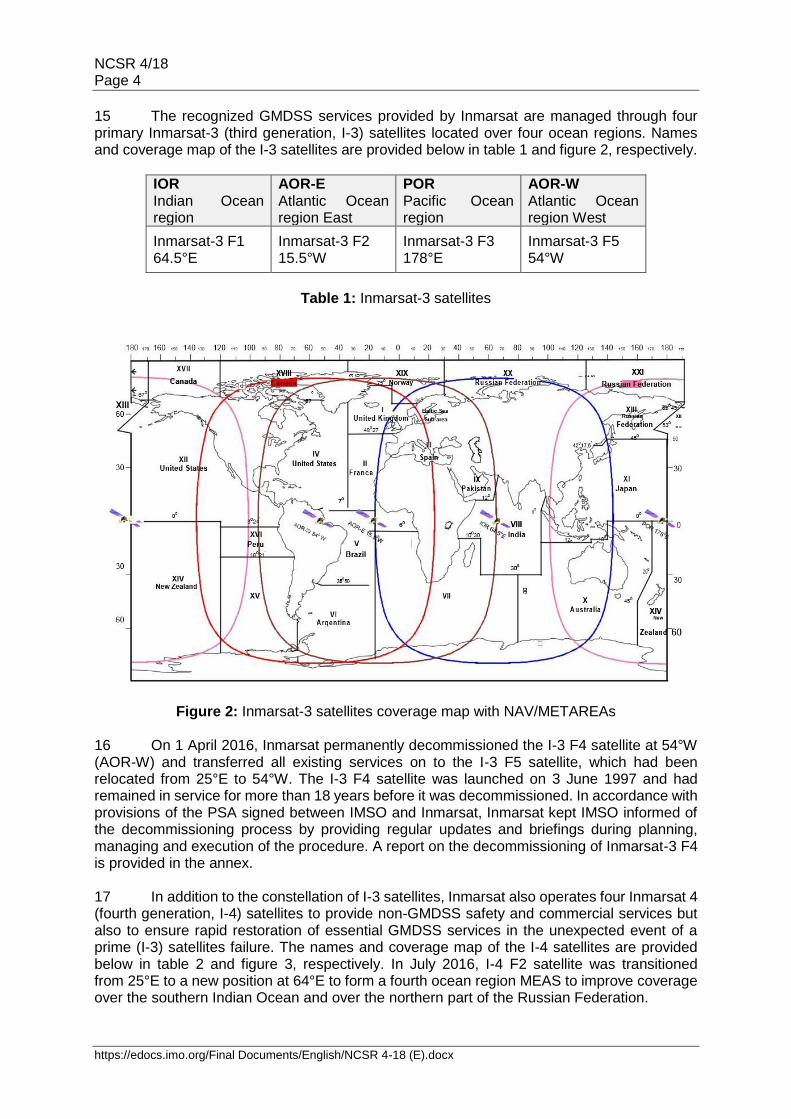
Action to be taken: Paragraph 2.
Related documents: NCSR4/18 dated 2 December 2016
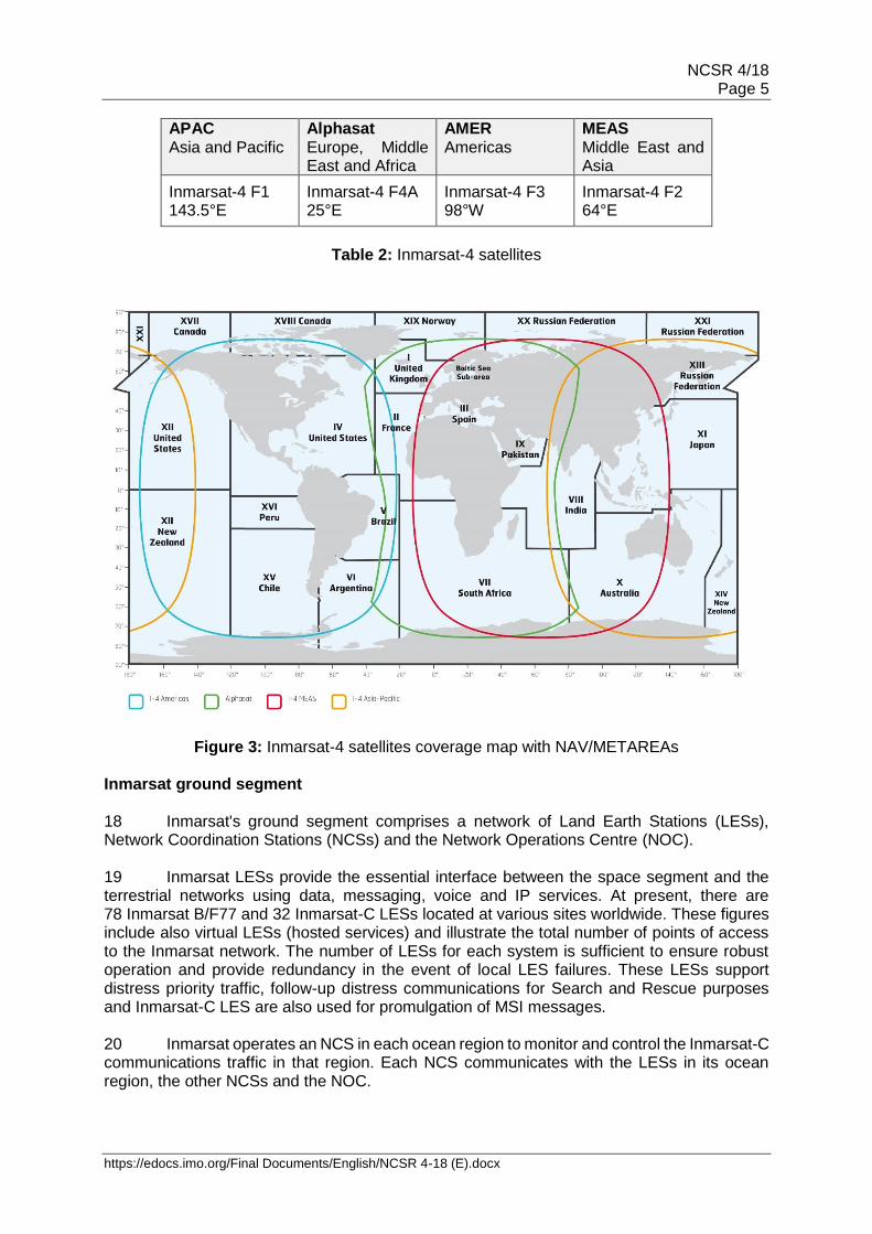
https://edocs.imo.org/Final Documents/English/NCSR 4-18 (E).docx
E
SUB-COMMITTEE ON NAVIGATION, COMMUNICATIONS AND SEARCH AND RESCUE 4th session Agenda item 18
NCSR 4/18
2 December 2016 Original: ENGLISH
DEVELOPMENTS IN GMDSS SATELLITE SERVICES
Analysis and assessment of the GMDSS performance of Inmarsat Global Limited
Submitted by the International Mobile Satellite Organization (IMSO)
SUMMARY
Executive summary: This document contains the annual report to IMO by IMSO on Inmarsat's public service obligations for the provision of recognized mobile satellite communication services in the Global Maritime Distress and Safety System (GMDSS), as overseen by IMSO
Strategic direction: 5.2
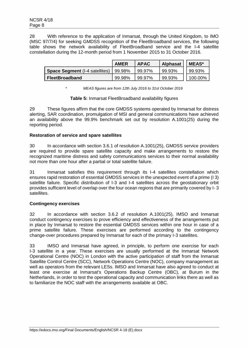
High-level action: 5.2.5
Output: 5.2.5.2
Action to be taken: Paragraph 61
Related document: NCSR 1/18/1; NCSR 2/14/1; NCSR 3/19; resolutions A.707(17), A.801(19), A.814(19) and A.1001(25)
Introduction 1 This document is the annual report to IMO by the International Mobile Satellite Organization (IMSO) on the performance of Inmarsat Global Limited (Inmarsat) as the mobile-satellite communication system recognized to operate in the GMDSS. The report is prepared and submitted in accordance with the provision of section 2.5 of the annex to the IMO Assembly resolution A.1001(25) on Criteria for the provision of mobile satellite communication systems in the Global Maritime Distress and Safety System (GMDSS). 2 Inmarsat's public service obligations with respect to the GMDSS are established in articles 3(1) and 5 of the Convention on the International Mobile Satellite Organization and they are exercised through the Public Services Agreement (PSA) signed between IMSO and Inmarsat in 1999. 3 This report covers the period from 1 November 2015 to 31 October 2016. The previous report to IMO, covering the period 1 November 2014 to 31 October 2015, was made to the third session of the Sub-Committee in document NCSR 3/19.
NCSR 4/18 Page 2
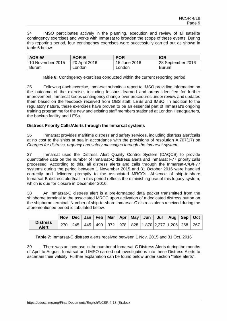
https://edocs.imo.org/Final Documents/English/NCSR 4-18 (E).docx
Inmarsat communication systems for use in the GMDSS 4 Inmarsat offers a range of communication services to fulfil the functional requirements listed in resolution A.1001(25) in particular the maritime distress, urgency, safety and routine communications, including broadcast of maritime safety information (MSI). The GMDSS compliant communication systems currently supported and provided by Inmarsat are listed as follows:
.1 Inmarsat-C is the base satellite communications system primarily used for distress alerting and reception of Maritime Safety Information (MSI), including shore-to-ship distress relay messages. It is a two-way store and forward system that can handle data and messages up to 32KB. Inmarsat-C is also utilized for other IMO systems such as Ship Security Alerting System (SSAS) and Long-Range Identification and Tracking of ships (LRIT);
.2 Inmarsat-B is a two-way direct-dial voice system used in the GMDSS for
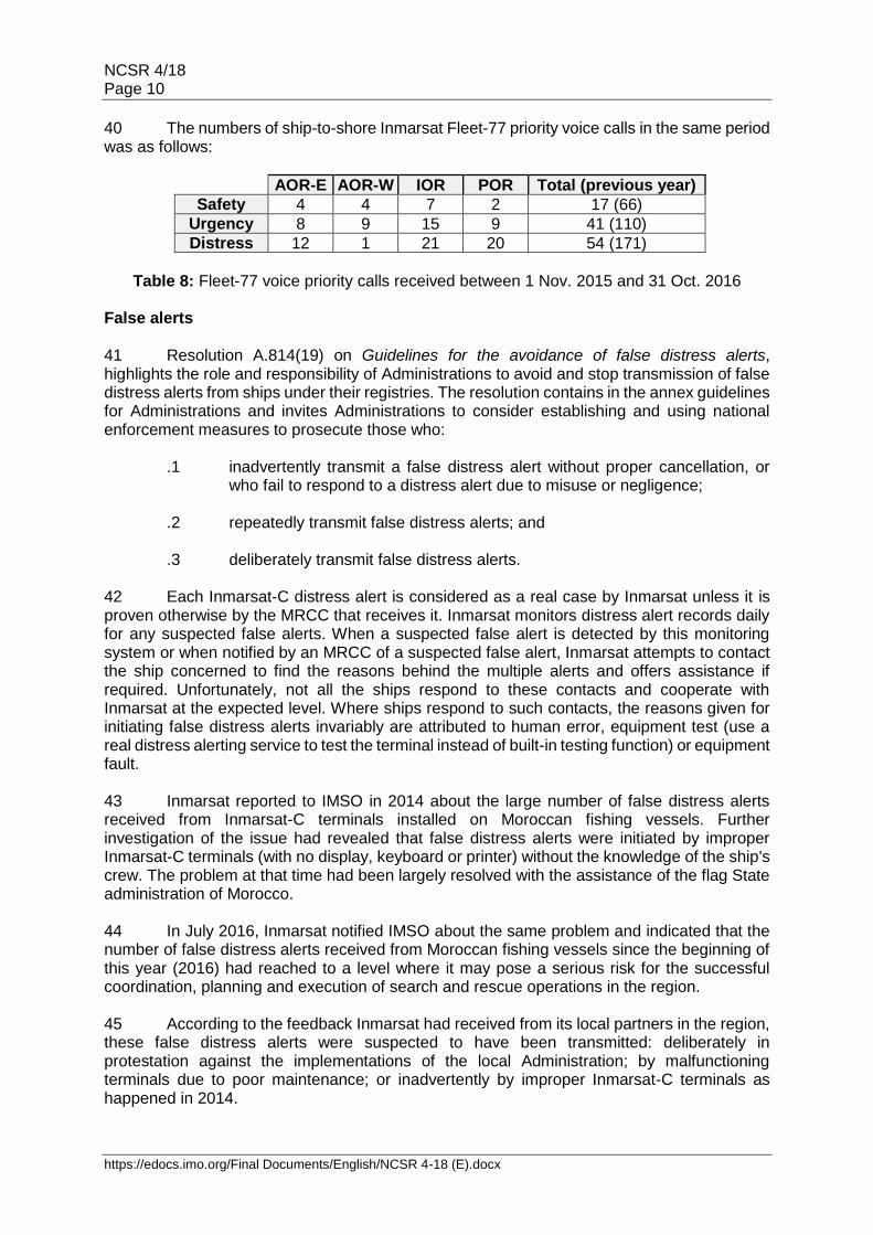
distress calling as well as general communications; and .3 Inmarsat F/77 provides two-way distress voice communication service for
the GMDSS. It also supports urgency and safety priority communications in ship-to-shore and shore-to-ship direction.
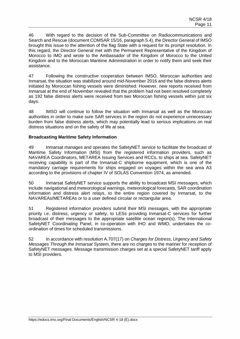
5 Inmarsat-A system, which was the original analogue service introduced in 1982, had been withdrawn from service by Inmarsat on 31 December 2007 (MSC/Circ.1076). Closure of Inmarsat-B system 6 Inmarsat, through IMSO, had previously notified IMO of its intention to close the Inmarsat-B system with effect from 31 December 2014 (COMSAR 14/INF.6). Further to that, the company postponed the closure date by two years to 30 December 2016 due to the significant number of ships still utilizing the service at that time and notified IMO, through IMSO, of the new closure date (document NCSR 1/18/1). 7 Since the first notice to IMO, Inmarsat has been conducting a broad public notification campaign to inform all users that the two-way direct-dial voice system will be closed on 30 December 2016. As part of this campaign, Inmarsat issued two broadcasts, on 1 July and 1 November 2016, to all Inmarsat-C terminals, via the Inmarsat SafetyNET, to advise mariners of the closure date of the Inmarsat-B system and to offer any assistance they may require. IMSO will continue to monitor the rest of the withdrawal process with Inmarsat until the Inmarsat-B system is closed on 30 December 2016. 8 IMSO is of the view that Inmarsat fulfilled its responsibility towards the maritime community by providing ample time and options for an orderly and cost-efficient migration to alternative communication systems. Inmarsat has affirmed that the company will follow the same practice for the termination of any future system/services. 9 Subsequent to the closure of the Inmarsat-B service on 30 December 2016, consequential amendments to annexes 1, 5 and 6 of the GMDSS Master Plan would be required to delete references to the Inmarsat-B service.
NCSR 4/18 Page 3
https://edocs.imo.org/Final Documents/English/NCSR 4-18 (E).docx
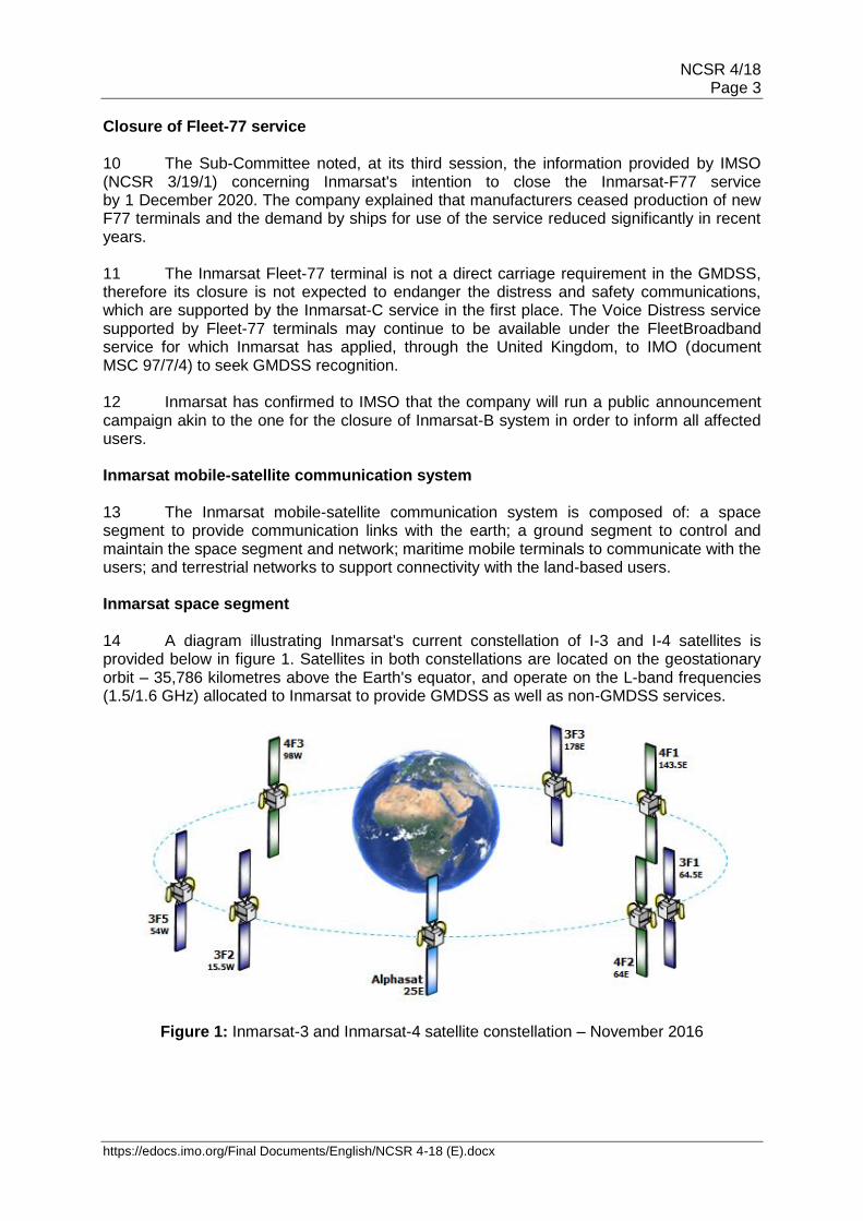
Closure of Fleet-77 service 10 The Sub-Committee noted, at its third session, the information provided by IMSO (NCSR 3/19/1) concerning Inmarsat's intention to close the Inmarsat-F77 service by 1 December 2020. The company explained that manufacturers ceased production of new F77 terminals and the demand by ships for use of the service reduced significantly in recent years. 11 The Inmarsat Fleet-77 terminal is not a direct carriage requirement in the GMDSS, therefore its closure is not expected to endanger the distress and safety communications, which are supported by the Inmarsat-C service in the first place. The Voice Distress service supported by Fleet-77 terminals may continue to be available under the FleetBroadband service for which Inmarsat has applied, through the United Kingdom, to IMO (document MSC 97/7/4) to seek GMDSS recognition. 12 Inmarsat has confirmed to IMSO that the company will run a public announcement campaign akin to the one for the closure of Inmarsat-B system in order to inform all affected users. Inmarsat mobile-satellite communication system 13 The Inmarsat mobile-satellite communication system is composed of: a space segment to provide communication links with the earth; a ground segment to control and maintain the space segment and network; maritime mobile terminals to communicate with the users; and terrestrial networks to support connectivity with the land-based users. Inmarsat space segment 14 A diagram illustrating Inmarsat's current constellation of I-3 and I-4 satellites is provided below in figure 1. Satellites in both constellations are located on the geostationary orbit – 35,786 kilometres above the Earth's equator, and operate on the L-band frequencies (1.5/1.6 GHz) allocated to Inmarsat to provide GMDSS as well as non-GMDSS services.
Figure 1: Inmarsat-3 and Inmarsat-4 satellite constellation – November 2016
NCSR 4/18 Page 4
https://edocs.imo.org/Final Documents/English/NCSR 4-18 (E).docx
15 The recognized GMDSS services provided by Inmarsat are managed through four primary Inmarsat-3 (third generation, I-3) satellites located over four ocean regions. Names and coverage map of the I-3 satellites are provided below in table 1 and figure 2, respectively.
IOR Indian Ocean region
AOR-E Atlantic Ocean region East
POR Pacific Ocean region
AOR-W Atlantic Ocean region West
Inmarsat-3 F1 64.5°E
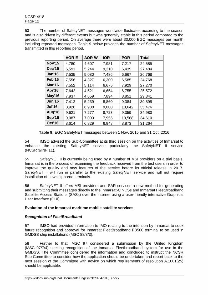
Inmarsat-3 F2 15.5°W
Inmarsat-3 F3 178°E
Inmarsat-3 F5 54°W
Table 1: Inmarsat-3 satellites
Figure 2: Inmarsat-3 satellites coverage map with NAV/METAREAs 16 On 1 April 2016, Inmarsat permanently decommissioned the I-3 F4 satellite at 54°W (AOR-W) and transferred all existing services on to the I-3 F5 satellite, which had been relocated from 25°E to 54°W. The I-3 F4 satellite was launched on 3 June 1997 and had remained in service for more than 18 years before it was decommissioned. In accordance with provisions of the PSA signed between IMSO and Inmarsat, Inmarsat kept IMSO informed of the decommissioning process by providing regular updates and briefings during planning, managing and execution of the procedure. A report on the decommissioning of Inmarsat-3 F4 is provided in the annex. 17 In addition to the constellation of I-3 satellites, Inmarsat also operates four Inmarsat 4 (fourth generation, I-4) satellites to provide non-GMDSS safety and commercial services but also to ensure rapid restoration of essential GMDSS services in the unexpected event of a prime (I-3) satellites failure. The names and coverage map of the I-4 satellites are provided below in table 2 and figure 3, respectively. In July 2016, I-4 F2 satellite was transitioned from 25°E to a new position at 64°E to form a fourth ocean region MEAS to improve coverage over the southern Indian Ocean and over the northern part of the Russian Federation.
NCSR 4/18 Page 5
https://edocs.imo.org/Final Documents/English/NCSR 4-18 (E).docx
APAC Asia and Pacific
Alphasat Europe, Middle East and Africa
AMER Americas
MEAS Middle East and Asia
Inmarsat-4 F1 143.5°E
Inmarsat-4 F4A 25°E
Inmarsat-4 F3 98°W
Inmarsat-4 F2 64°E
Table 2: Inmarsat-4 satellites
Figure 3: Inmarsat-4 satellites coverage map with NAV/METAREAs Inmarsat ground segment 18 Inmarsat's ground segment comprises a network of Land Earth Stations (LESs), Network Coordination Stations (NCSs) and the Network Operations Centre (NOC). 19 Inmarsat LESs provide the essential interface between the space segment and the terrestrial networks using data, messaging, voice and IP services. At present, there are 78 Inmarsat B/F77 and 32 Inmarsat-C LESs located at various sites worldwide. These figures include also virtual LESs (hosted services) and illustrate the total number of points of access to the Inmarsat network. The number of LESs for each system is sufficient to ensure robust operation and provide redundancy in the event of local LES failures. These LESs support distress priority traffic, follow-up distress communications for Search and Rescue purposes and Inmarsat-C LES are also used for promulgation of MSI messages. 20 Inmarsat operates an NCS in each ocean region to monitor and control the Inmarsat-C communications traffic in that region. Each NCS communicates with the LESs in its ocean region, the other NCSs and the NOC.
NCSR 4/18 Page 6
https://edocs.imo.org/Final Documents/English/NCSR 4-18 (E).docx
21 The Inmarsat NOC is located in London at the Inmarsat headquarters and functions around the clock to monitor and coordinate the activities of the NCSs and the LESs in each ocean region. 22 According to resolution A.801(19) on the Provision of radio services for the GMDSS, each LES "should have a registered associated Rescue Coordination Centre (RCC) and have reliable communications by telephone, telex or other means". Table 3 below provides the list of Inmarsat-C LESs as well as their operators, names, geographical locations and IDs together with names of the associated RCCs where ship-to-shore distress alerts and distress priority messages are automatically routed to.
Country LES Name Region LES Operator LES ID
Associated RCC
Netherlands Burum
AOR-E
Stratos Global
102 MRCC Falmouth
AOR-E 112 JRCC Den Helder
AOR-W 002 MRCC Falmouth
AOR-W 012 JRCC Den Helder
Norway Eik
AOR-E
Vizada
101 USCG Norfolk
AOR-E 104 JRCC Stavanger
AOR-W 001 USCG Norfolk
AOR-W 004 JRCC Stavanger
France Yamaguchi at Assaguel
AOR-E KDDI 103 Opr. Centre, Tokyo
AOR-E Vizada 121 CROSS Griz-Nez
AOR-W KDDI 003 Opr. Centre, Tokyo
AOR-W Vizada 021 CROSS Griz-Nez
IOR Vizada 321 CROSS Griz-Nez
Italy Fucino AOR-E
Telecom Italia 105 CG Rome
IOR 335 CG Rome
USA Santa Paula
POR Vizada
201 USCG Alameda
POR 204 JRCC Stavanger
India Pune IOR TATA Comm 306 MRCC Mumbai
Australia Perth
IOR
Stratos Global
302 MRCC Falmouth
IOR 312 RCC Australia
POR 202 MRCC Falmouth
POR 212 RCC Australia
China Beijing IOR
MCN 311 MRCC Beijing
POR 211 MRCC Beijing
Japan Yamaguchi
IOR KDDI
303 Opr. Centre, Tokyo
POR 203 Opr. Centre, Tokyo
Assaguel at Yamaguchi
POR Vizada 221 CROSS Griz-Nez
Singapore Sentosa IOR Singapore
Telecom
328 Port Opr. Control Centre
POR 210 Port Opr. Control Centre
Viet Nam Hai Phong IOR Vishipel 330 MRCC Viet Nam
Russian Federation
Nudol IOR Morsviazsputnik 317 MRCC Moscow
Nakhodka POR Morsviazsputnik 217 MRCC Vladivostok Note: Information on LES names is correct as at October 2016 based on the most up-to-date information
available to Inmarsat
Table 3: Inmarsat-C Land Earth Stations and associated MRCCs
NCSR 4/18 Page 7
https://edocs.imo.org/Final Documents/English/NCSR 4-18 (E).docx
Maritime mobile terminal 23 According to the reports received from Inmarsat, more than 176,000 Inmarsat-B, Inmarsat-C, Mini-C and Inmarsat F77 terminals were registered with Inmarsat at the end of October 2016. This includes more than 86,000 Inmarsat-C and in excess of 73,000 mini-C terminals, some of which are GMDSS compliant. Terrestrial networks 24 Inmarsat's network is connected to RCCs, NAVAREA Coordinators and METAREA Issuing Services in order to facilitate distress priority traffic, follow-up distress communications and promulgation of Maritime Safety Information (SafetyNET). The means of interconnection between Inmarsat network and RCCs or MSI providers varies from country to country and in some cases include the use of dedicated lines or public switched telephone networks. 25 For instance, some LESs provide email, or internet (direct) drop access to the SafetyNET service that allows registered MSI providers to send Enhanced Group Call (EGC) messages using email from any computer with access to the internet. Each user interface has its own access procedure and syntax command, which should be checked with the Inmarsat-C LES operator or service provider. 26 In accordance with resolution A.801(19), the availability and robustness of the communication links between LESs and the associated RCCs, or other shore-based national agencies, are under the responsibility of the Government(s) in whose territory the LES is located. Nevertheless, at least two LESs are located in each ocean region under Inmarsat's coverage area in order to provide sufficient level of robustness as well as redundancy. Availability 27 In accordance with section 3.5.2 of resolution A.1001(25), IMSO monitors the availability of Inmarsat's space segment, provision of spare satellite capacity and network control function, and reports to IMO on an annual basis. The network availability of a recognized mobile satellite communication system is expected to achieve at least 99.9% in a given year. In this context, the network availability of the Inmarsat-C and B/F77 systems during the 12-month period from 1 November 2015 to 31 October 2016 is shown below.
IOR POR AOR-E AOR-W
Space Segment (I-3 satellites) 100.00% 100.00% 100.00% 100.00%
Inmarsat B/F77 100.00% 100.00% 100.00% 100.00%
Inmarsat C 100.00% 100.00% 100.00% 100.00%
The definition of availability and methods of calculation in the Maritime Mobile Satellite Service are given in ITU Recommendation ITU-R M.828-2 (03/06), which superseded ITU-R M. 828-1 of 1992-1994.
Table 4: Inmarsat B/F77/C availability figures
NCSR 4/18 Page 8
https://edocs.imo.org/Final Documents/English/NCSR 4-18 (E).docx
28 With reference to the application of Inmarsat, through the United Kingdom, to IMO (MSC 97/7/4) for seeking GMDSS recognition of the FleetBroadband services, the following table shows the network availability of FleetBroadband service and the I-4 satellite constellation during the 12-month period from 1 November 2015 to 31 October 2016.
AMER APAC Alphasat MEAS*
Space Segment (I-4 satellites) 99.98% 99.97% 99.93% 99.93%
FleetBroadband 99.98% 99.97% 99.93% 100.00%
* MEAS figures are from 12th July 2016 to 31st October 2016
Table 5: Inmarsat FleetBroadband availability figures
29 These figures affirm that the core GMDSS systems operated by Inmarsat for distress alerting, SAR coordination, promulgation of MSI and general communications have achieved an availability above the 99.9% benchmark set out by resolution A.1001(25) during the reporting period. Restoration of service and spare satellites 30 In accordance with section 3.6.1 of resolution A.1001(25), GMDSS service providers are required to provide spare satellite capacity and make arrangements to restore the recognized maritime distress and safety communications services to their normal availability not more than one hour after a partial or total satellite failure. 31 Inmarsat satisfies this requirement through its I-4 satellites constellation which ensures rapid restoration of essential GMDSS services in the unexpected event of a prime (I 3) satellite failure. Specific distribution of I-3 and I-4 satellites across the geostationary orbit provides sufficient level of overlap over the four ocean regions that are primarily covered by I- 3 satellites. Contingency exercises 32 In accordance with section 3.6.2 of resolution A.1001(25), IMSO and Inmarsat conduct contingency exercises to prove efficiency and effectiveness of the arrangements put in place by Inmarsat to restore the essential GMDSS services within one hour in case of a prime satellite failure. These exercises are performed according to the contingency change-over procedures prepared by Inmarsat for each of the primary I-3 satellites. 33 IMSO and Inmarsat have agreed, in principle, to perform one exercise for each I-3 satellite in a year. These exercises are usually performed at the Inmarsat Network Operational Centre (NOC) in London with the active participation of staff from the Inmarsat Satellite Control Centre (SCC), Network Operations Centre (NOC), company management as well as operators from the relevant LESs. IMSO and Inmarsat have also agreed to conduct at least one exercise at Inmarsat's Operations Backup Centre (OBC), at Burum in the Netherlands, in order to test the operational capacity and communication links there as well as to familiarize the NOC staff with the arrangements available at OBC.
NCSR 4/18 Page 9
https://edocs.imo.org/Final Documents/English/NCSR 4-18 (E).docx
34 IMSO participates actively in the planning, execution and review of all satellite contingency exercises and works with Inmarsat to broaden the scope of these events. During this reporting period, four contingency exercises were successfully carried out as shown in table 6 below:
AOR-W AOR-E POR IOR
10 November 2015 Burum
20 April 2016 London
15 June 2016 London
28 September 2016 Burum
Table 6: Contingency exercises conducted within the current reporting period
35 Following each exercise, Inmarsat submits a report to IMSO providing information on the outcome of the exercise, including lessons learned and areas identified for further improvement. Inmarsat keeps contingency change-over procedures under review and updates them based on the feedback received from OBS staff, LESs and IMSO. In addition to the regulatory nature, these exercises have proven to be an essential part of Inmarsat's ongoing training programme for the new and existing staff members stationed at London Headquarters, the backup facility and LESs. Distress Priority Calls/Alerts through the Inmarsat systems 36 Inmarsat provides maritime distress and safety services, including distress alert/calls at no cost to the ships at sea in accordance with the provisions of resolution A.707(17) on Charges for distress, urgency and safety messages through the Inmarsat system. 37 Inmarsat uses the Distress Alert Quality Control System (DAQCS) to provide quantitative data on the number of Inmarsat-C distress alerts and Inmarsat F77 priority calls processed. According to this, all distress alerts and calls through the Inmarsat-C/B/F77 systems during the period between 1 November 2015 and 31 October 2016 were handled correctly and delivered promptly to the associated MRCCs. Absence of ship-to-shore Inmarsat-B distress alert/call in this period reflects the diminishing use of this legacy system, which is due for closure in December 2016. 38 An Inmarsat-C distress alert is a pre-formatted data packet transmitted from the shipborne terminal to the associated MRCC upon activation of a dedicated distress button on the shipborne terminal. Number of ship-to-shore Inmarsat-C distress alerts received during the aforementioned period is tabulated below.
Nov Dec Jan Feb Mar Apr May Jun Jul Aug Sep Oct
Distress Alert
270 245 445 490 372 978 828 1,870 2,277 1,206 268 267
Table 7: Inmarsat-C distress alerts received between 1 Nov. 2015 and 31 Oct. 2016
39 There was an increase in the number of Inmarsat-C Distress Alerts during the months of April to August. Inmarsat and IMSO carried out investigations into these Distress Alerts to ascertain their validity. Further explanation can be found below under section "false alerts".
NCSR 4/18 Page 10
https://edocs.imo.org/Final Documents/English/NCSR 4-18 (E).docx
40 The numbers of ship-to-shore Inmarsat Fleet-77 priority voice calls in the same period was as follows:
AOR-E AOR-W IOR POR Total (previous year)
Safety 4 4 7 2 17 (66)
Urgency 8 9 15 9 41 (110)
Distress 12 1 21 20 54 (171)
Table 8: Fleet-77 voice priority calls received between 1 Nov. 2015 and 31 Oct. 2016
False alerts 41 Resolution A.814(19) on Guidelines for the avoidance of false distress alerts, highlights the role and responsibility of Administrations to avoid and stop transmission of false distress alerts from ships under their registries. The resolution contains in the annex guidelines for Administrations and invites Administrations to consider establishing and using national enforcement measures to prosecute those who:
.1 inadvertently transmit a false distress alert without proper cancellation, or who fail to respond to a distress alert due to misuse or negligence;
.2 repeatedly transmit false distress alerts; and .3 deliberately transmit false distress alerts.
42 Each Inmarsat-C distress alert is considered as a real case by Inmarsat unless it is proven otherwise by the MRCC that receives it. Inmarsat monitors distress alert records daily for any suspected false alerts. When a suspected false alert is detected by this monitoring system or when notified by an MRCC of a suspected false alert, Inmarsat attempts to contact the ship concerned to find the reasons behind the multiple alerts and offers assistance if required. Unfortunately, not all the ships respond to these contacts and cooperate with Inmarsat at the expected level. Where ships respond to such contacts, the reasons given for initiating false distress alerts invariably are attributed to human error, equipment test (use a real distress alerting service to test the terminal instead of built-in testing function) or equipment fault. 43 Inmarsat reported to IMSO in 2014 about the large number of false distress alerts received from Inmarsat-C terminals installed on Moroccan fishing vessels. Further investigation of the issue had revealed that false distress alerts were initiated by improper Inmarsat-C terminals (with no display, keyboard or printer) without the knowledge of the ship's crew. The problem at that time had been largely resolved with the assistance of the flag State administration of Morocco. 44 In July 2016, Inmarsat notified IMSO about the same problem and indicated that the number of false distress alerts received from Moroccan fishing vessels since the beginning of this year (2016) had reached to a level where it may pose a serious risk for the successful coordination, planning and execution of search and rescue operations in the region. 45 According to the feedback Inmarsat had received from its local partners in the region, these false distress alerts were suspected to have been transmitted: deliberately in protestation against the implementations of the local Administration; by malfunctioning terminals due to poor maintenance; or inadvertently by improper Inmarsat-C terminals as happened in 2014.
NCSR 4/18 Page 11
https://edocs.imo.org/Final Documents/English/NCSR 4-18 (E).docx
46 With regard to the decision of the Sub-Committee on Radiocommunications and Search and Rescue (document COMSAR 15/16, paragraph 5.4), the Director General of IMSO brought this issue to the attention of the flag State with a request for its prompt resolution. In this regard, the Director General met with the Permanent Representative of the Kingdom of Morocco to IMO and wrote to the Ambassador of the Kingdom of Morocco to the United Kingdom and to the Moroccan Maritime Administration in order to notify them and seek their assistance. 47 Following the constructive cooperation between IMSO, Moroccan authorities and Inmarsat, the situation was stabilized around mid-November 2016 and the false distress alerts initiated by Moroccan fishing vessels were diminished. However, new reports received from Inmarsat at the end of November revealed that the problem had not been resolved completely as 192 false distress alerts were received from two Moroccan fishing vessels within just six days. 48 IMSO will continue to follow the situation with Inmarsat as well as the Moroccan authorities in order to make sure SAR services in the region do not experience unnecessary burden from false distress alerts, which may potentially lead to serious implications on real distress situations and on the safety of life at sea. Broadcasting Maritime Safety Information 49 Inmarsat manages and operates the SafetyNET service to facilitate the broadcast of Maritime Safety Information (MSI) from the registered information providers, such as NAVAREA Coordinators, METAREA Issuing Services and RCCs, to ships at sea. SafetyNET receiving capability is part of the Inmarsat-C shipborne equipment, which is one of the mandatory carriage requirements for ships engaged on voyages within the sea area A3 according to the provisions of chapter IV of SOLAS Convention 1974, as amended. 50 Inmarsat SafetyNET service supports the ability to broadcast MSI messages, which include navigational and meteorological warnings, meteorological forecasts, SAR coordination information and distress alert relays, to the entire region covered by Inmarsat, to the NAVAREAs/METAREAs or to a user defined circular or rectangular area. 51 Registered information providers submit their MSI messages, with the appropriate priority i.e. distress, urgency or safety, to LESs providing Inmarsat-C services for further broadcast of their messages to the appropriate satellite ocean region(s). The International SafetyNET Coordinating Panel, in co-operation with IHO and WMO, undertakes the co-ordination of times for scheduled transmissions. 52 In accordance with resolution A.707(17) on Charges for Distress, Urgency and Safety Messages Through the Inmarsat System, there are no charges to the mariner for reception of SafetyNET messages. Message transmission charges set at a special SafetyNET tariff apply to MSI providers.
NCSR 4/18 Page 12
https://edocs.imo.org/Final Documents/English/NCSR 4-18 (E).docx
53 The number of SafetyNET messages worldwide fluctuates according to the season and is also driven by different events but was generally stable in this period compared to the previous reporting period. On average there were about 30,000 EGC messages per month including repeated messages. Table 9 below provides the number of SafetyNET messages transmitted in this reporting period.
AOR-E AOR-W IOR POR Total
Nov'15 4,780 4,607 7,981 7,217 24,585
Dec'15 6,591 5,244 9,210 6,439 27,484
Jan'16 7,535 5,080 7,486 6,667 26,768
Feb'16 7,556 4,327 6,300 6,585 24,768
Mar'16 7,552 5,114 6,675 7,929 27,270
Apr'16 7,642 4,521 6,654 6,755 25,572
May'16 7,937 4,659 7,894 8,851 29,341
Jun'16 7,412 5,239 8,860 9,384 30,895
Jul'16 8,926 6,908 9,000 10,642 35,476
Aug'16 9,621 7,277 8,723 9,359 34,980
Sep'16 9,087 7,000 7,955 10,568 34,610
Oct'16 8,614 6,829 6,948 8,873 31,264
Table 9: EGC SafetyNET messages between 1 Nov. 2015 and 31 Oct. 2016
54 IMSO advised the Sub-Committee at its third session on the activities of Inmarsat to enhance the existing SafetyNET service particularly the SafetyNET II service (NCSR 3/INF.11).
55 SafetyNET II is currently being used by a number of MSI providers on a trial basis. Inmarsat is in the process of examining the feedback received from the test users in order to improve the quality and new features of the service before its official release in 2017. SafetyNET II will run in parallel to the existing SafetyNET service and will not require installation of new shipborne terminals. 56 SafetyNET II offers MSI providers and SAR services a new method for generating and submitting their messages directly to the Inmarsat-C NCSs and Inmarsat FleetBroadband Satellite Access Stations (SASs) over the internet using a user-friendly interactive Graphical User Interface (GUI). Evolution of the Inmarsat maritime mobile satellite services Recognition of FleetBroadband 57 IMSO had provided information to IMO relating to the intention by Inmarsat to seek future recognition and approval for Inmarsat FleetBroadband FB500 terminal to be used in GMDSS ship installations (MSC 88/8/3). 58 Further to that, MSC 97 considered a submission by the United Kingdom (MSC 97/7/4) seeking recognition of the Inmarsat Fleetbroadband system for use in the GMDSS. The Committee considered the information and concluded to instruct the NCSR Sub-Committee to consider how the application should be undertaken and report back to the next session of the Committee with advice on which requirements of resolution A.1001(25) should be applicable.
NCSR 4/18 Page 13
https://edocs.imo.org/Final Documents/English/NCSR 4-18 (E).docx
Inmarsat-6 satellites 59 Inmarsat has announced its programme for the next-generation of satellites – Inmarsat-6 with the first launch expected in 2020 followed by another soon thereafter. Inmarsat-6 satellites will reportedly feature dual-band technology that will support reliability of the L-band and performance of the Ka-band simultaneously. Furthermore, Inmarsat-6 satellites will provide backward compatibility with the I-3 and I-4 satellites, which also operate on L-band frequencies, thus ensuring continuation of GMDSS services by Inmarsat beyond 2020. Conclusions 60 In view of the aforementioned information, it is IMSO's overall assessment that, during the period covered by this report, Inmarsat Global Ltd has continued to provide fully operational maritime mobile satellite distress and safety communication services for the GMDSS and fulfilled the company's public service obligation as stated in the PSA. Action requested of the Sub-Committee 61 The Sub-Committee is invited to note the information provided in this document, including the conclusion of IMSO's overall assessment (paragraph 60) and, in particular, the:
.1 closure of Inmarsat-B services on 30 December 2016 and the need for consequential amendments in annexes 1, 5 and 6 of the GMDSS Master Plan (paragraphs 6 to 9);
.2 report on the decommissioning of Inmarsat-3 F4 (annex); .3 availability of the mobile satellite communication systems operated by
Inmarsat between 1 November 2015 to 31 October 2016 (paragraphs 27 to 29);
.4 arrangements by Inmarsat for restoration of service and spare satellites
capacity (paragraphs 30 and 31); .5 ongoing programme of satellite contingency exercises (paragraphs 32 to 35);
and .6 ongoing efforts to reduce false alerts (paragraphs 41 to 48).
***

NCSR 4/18 Annex, page 1
https://edocs.imo.org/Final Documents/English/NCSR 4-18 (E).docx
ANNEX
REPORT ON THE DECOMMISSIONING OF INMARSAT-3 F4 SATELLITE
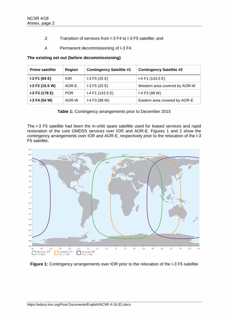
Background The Director General, as a part of IMSO's GMDSS oversight role, provided relevant information to the Advisory Committee, at its thirty-eight session held at IMO Headquarters on 10 May 2016 on the decommissioning of the Inmarsat-3 F4 satellite and the measures taken by Inmarsat to avoid interruption of the GMDSS services in the affected ocean region. This report has been prepared by the Director General in response to the request of the Advisory Committee and it contains detailed information on the decommissioning procedure, including its impact on the recognized GMDSS services provided by Inmarsat. Introduction / I-3 F4 satellite The I-3 F4 satellite was manufactured by Lockheed Martin for Inmarsat and launched from French Guiana on 3 June 1997 using an Ariane 44L rocket. The satellite was the fourth of the five third-generation satellites launched by Inmarsat between 1996 and 1998. The spot-beam technology, which enables greater control on satellite connectivity and capacity over a given geographic area on Earth, was used on Inmarsat-3 satellites for the first time. The I-3 F4 satellite featured one global and seven spot-beams for this purpose. The I-3 F4 satellite used the L-band frequencies (1.5/1.6 GHz) allocated to Inmarsat and supported the "existing and evolved" (E&E) services within Inmarsat's range of communication solutions. Inmarsat-B (will be closed on 31 December 2016), Inmarsat-C and Inmarsat-F77 are some of the E&E services that are of interest to the maritime users particularly. The I-3 F4 satellite was located at 54 W in geostationary orbit and was the prime satellite for the GMDSS services over AOR-W. Notification and planning In October 2015, Inmarsat announced plans for replacing the I-3 F4 satellite with the I-3 F5 satellite and for eventual decommissioning of I-3 F4. In accordance with the Public Services Agreement signed between IMSO and Inmarsat, Inmarsat subsequently notified the Director General in relation to the planned decommissioning of the I-3 F4 satellite. Upon the request of the Director General, Inmarsat provided relevant information in relation to the decommissioning procedure including measures taken to ensure spare satellite capacity and restoration of GMDSS services (within 60 minutes) as set out in resolution A.1001(25) on Criteria for the Provision of Mobile Satellite Communication Systems in the Global Maritime Distress and Safety System (GMDSS). The planned decommissioning of the I-3 F4 satellite led to the relocation of the I-3 F5 satellite from 25E to 54W to ensure continuation of the GMDSS services over AOR-W. The decommissioning was planned and conducted in four phases:
.1 The existing set out; .2 Relocation of I-3 F5 satellite;
NCSR 4/18 Annex, page 2
https://edocs.imo.org/Final Documents/English/NCSR 4-18 (E).docx
.3 Transition of services from I-3 F4 to I-3 F5 satellite; and .4 Permanent decommissioning of I-3 F4.
The existing set out (before decommissioning)
Prime satellite Region Contingency Satellite #1 Contingency Satellite #2
I-3 F1 (64 E) IOR I-3 F5 (25 E) I-4 F1 (143.5 E)
I-3 F2 (15.5 W) AOR-E I-3 F5 (25 E) Western area covered by AOR-W
I-3 F3 (178 E) POR I-4 F1 (143.5 E) I-4 F3 (98 W)
I-3 F4 (54 W) AOR-W I-4 F3 (98 W) Eastern area covered by AOR-E
Table 1: Contingency arrangements prior to December 2015
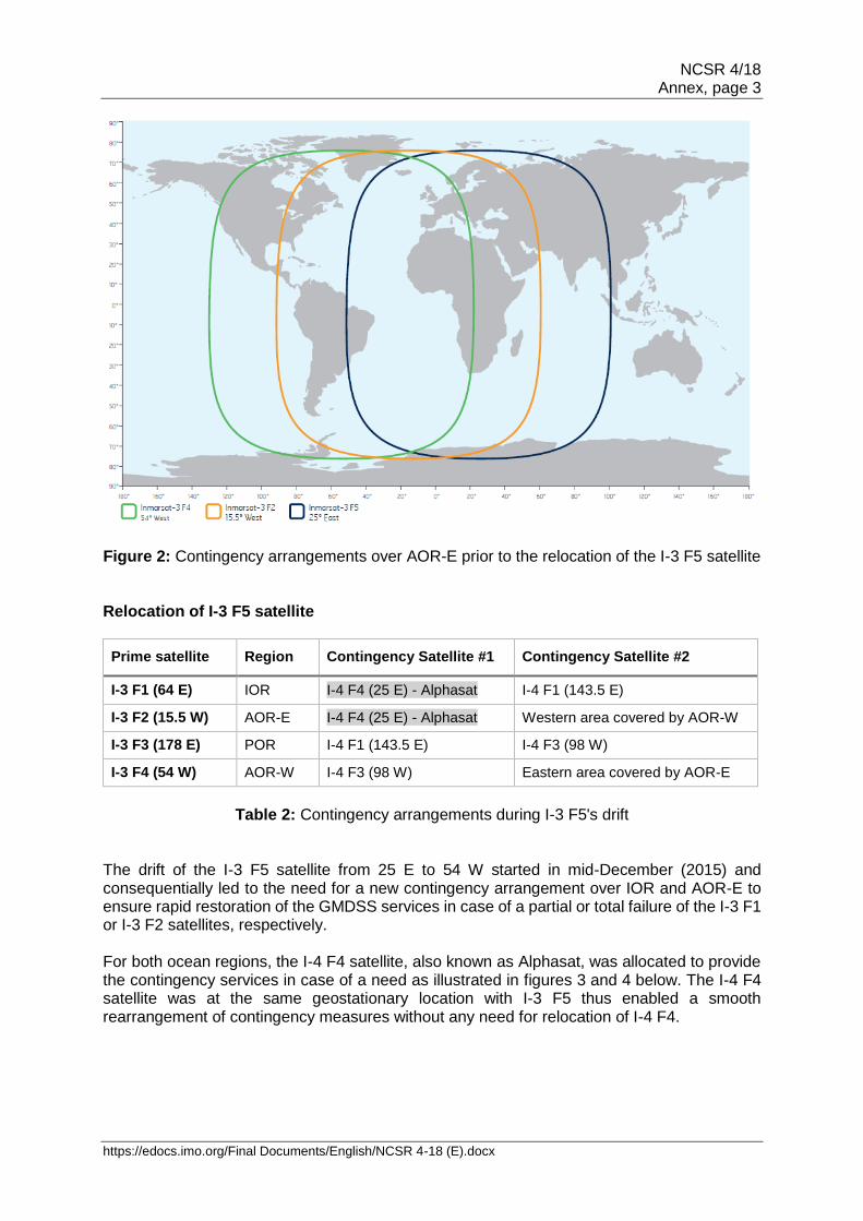
The I-3 F5 satellite had been the in-orbit spare satellite used for leased services and rapid restoration of the core GMDSS services over IOR and AOR-E. Figures 1 and 2 show the contingency arrangements over IOR and AOR-E, respectively prior to the relocation of the I-3 F5 satellite.
Figure 1: Contingency arrangements over IOR prior to the relocation of the I-3 F5 satellite
NCSR 4/18 Annex, page 3
https://edocs.imo.org/Final Documents/English/NCSR 4-18 (E).docx
Figure 2: Contingency arrangements over AOR-E prior to the relocation of the I-3 F5 satellite
Relocation of I-3 F5 satellite
Prime satellite Region Contingency Satellite #1 Contingency Satellite #2
I-3 F1 (64 E) IOR I-4 F4 (25 E) - Alphasat I-4 F1 (143.5 E)
I-3 F2 (15.5 W) AOR-E I-4 F4 (25 E) - Alphasat Western area covered by AOR-W
I-3 F3 (178 E) POR I-4 F1 (143.5 E) I-4 F3 (98 W)
I-3 F4 (54 W) AOR-W I-4 F3 (98 W) Eastern area covered by AOR-E
Table 2: Contingency arrangements during I-3 F5's drift
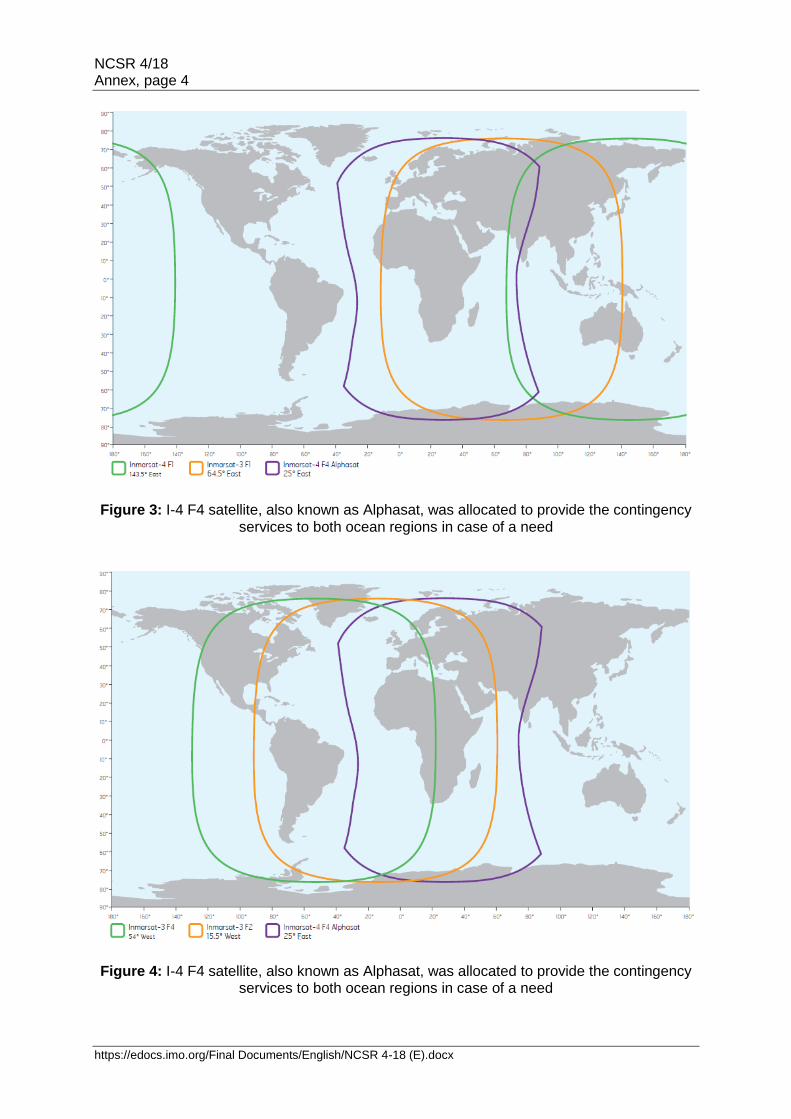
The drift of the I-3 F5 satellite from 25 E to 54 W started in mid-December (2015) and consequentially led to the need for a new contingency arrangement over IOR and AOR-E to ensure rapid restoration of the GMDSS services in case of a partial or total failure of the I-3 F1 or I-3 F2 satellites, respectively. For both ocean regions, the I-4 F4 satellite, also known as Alphasat, was allocated to provide the contingency services in case of a need as illustrated in figures 3 and 4 below. The I-4 F4 satellite was at the same geostationary location with I-3 F5 thus enabled a smooth rearrangement of contingency measures without any need for relocation of I-4 F4.
NCSR 4/18 Annex, page 4
https://edocs.imo.org/Final Documents/English/NCSR 4-18 (E).docx
Figure 3: I-4 F4 satellite, also known as Alphasat, was allocated to provide the contingency services to both ocean regions in case of a need
Figure 4: I-4 F4 satellite, also known as Alphasat, was allocated to provide the contingency services to both ocean regions in case of a need
NCSR 4/18 Annex, page 5
https://edocs.imo.org/Final Documents/English/NCSR 4-18 (E).docx
Transition of services from I-3 F4 to I-3 F5 satellite
Prime satellite Region Contingency Satellite #1 Contingency Satellite #2
I-3 F1 (64 E) IOR I-4 F4 (25 E) - Alphasat I-4 F1 (143.5 E)
I-3 F2 (15.5 W) AOR-E I-4 F4 (25 E) - Alphasat Western area covered by AOR-W
I-3 F3 (178 E) POR I-4 F1 (143.5 E) I-4 F3 (98 W)
I-3 F5 (54 W) AOR-W I-3 F4 (54 W) Not needed
Table 3: Contingency arrangements transition of services from I-3 F4 to I-3 F5 satellite
The I-3 F5 satellite completed its drift from 25 E to 54 W by 11 February 2016. Prior to the actual transition of services from I-3 F4 to I-3 F5 satellite in AOR-W, Inmarsat performed a rehearsal on 18th of February 2016 in order to familiarize the personnel and to make sure the transition procedure was fit for purpose. The Director General was invited by Inmarsat to join the Management Bridge during the rehearsal.
The actual transition of services from I-3 F4 to I-3 F5 satellite took place on 21 March 2016 and it was successfully completed without encountering any operational issues. The transition of the Inmarsat-C services took priority and confirmed to be restored within 14 minutes only. This was followed two minutes later by the restoration of the Inmarsat-F77 services.
After completion of the transition, the I-3 F4 satellite remained in orbit to provide the necessary backup for the I-3 F5 satellite, which has now become the new prime satellite for the GMDSS services over AOR-W.
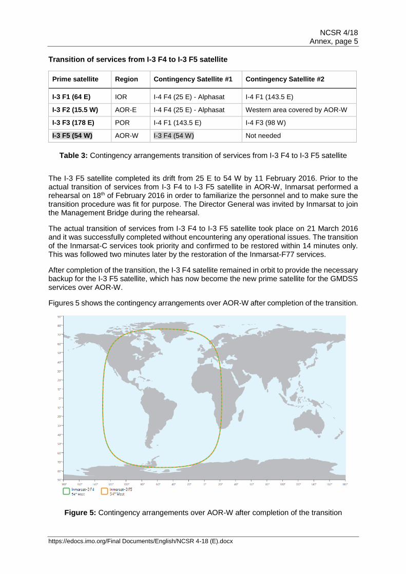
Figures 5 shows the contingency arrangements over AOR-W after completion of the transition.
Figure 5: Contingency arrangements over AOR-W after completion of the transition
NCSR 4/18 Annex, page 6
https://edocs.imo.org/Final Documents/English/NCSR 4-18 (E).docx
Permanent decommissioning of I-3 F4
Prime satellite Region Contingency Satellite #1 Contingency Satellite #2
I-3 F1 (64 E) IOR I-4 F4 (25 E) - Alphasat I-4 F1 (143.5 E)
I-3 F2 (15.5 W) AOR-E I-4 F4 (25 E) - Alphasat Western area covered by AOR-W
I-3 F3 (178 E) POR I-4 F1 (143.5 E) I-4 F3 (98 W)
I-3 F5 (54 W) AOR-W I-4 F3 (98 W) Eastern area covered by AOR-E
Table 4: Contingency arrangements transition of services from I-3 F4 to I-3 F5 satellite
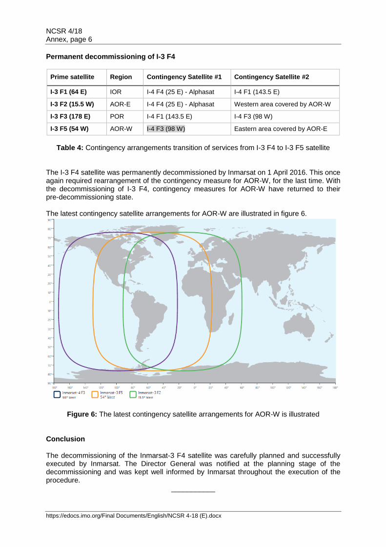
The I-3 F4 satellite was permanently decommissioned by Inmarsat on 1 April 2016. This once again required rearrangement of the contingency measure for AOR-W, for the last time. With the decommissioning of I-3 F4, contingency measures for AOR-W have returned to their pre-decommissioning state. The latest contingency satellite arrangements for AOR-W are illustrated in figure 6.
Figure 6: The latest contingency satellite arrangements for AOR-W is illustrated Conclusion The decommissioning of the Inmarsat-3 F4 satellite was carefully planned and successfully executed by Inmarsat. The Director General was notified at the planning stage of the decommissioning and was kept well informed by Inmarsat throughout the execution of the procedure.
___________