Embed Size (px)
Citation preview
Kaleidoscope
Volume 1 Article 15
2002
WWII Pacific Theatre MapsJacqueline D. GoinsUniversity of Kentucky, [email protected]
Follow this and additional works at: https://uknowledge.uky.edu/kaleidoscope
Part of the Geography Commons, and the Military History CommonsRight click to open a feedback form in a new tab to let us know how this document benefitsyou.
This Article is brought to you for free and open access by the The Office of Undergraduate Research at UKnowledge. It has been accepted for inclusionin Kaleidoscope by an authorized editor of UKnowledge. For more information, please contact [email protected].
Recommended CitationGoins, Jacqueline D. (2002) "WWII Pacific Theatre Maps," Kaleidoscope: Vol. 1, Article 15.Available at: https://uknowledge.uky.edu/kaleidoscope/vol1/iss1/15
:dhow
~aped;
d stop to see
lready
o.ed in 1t as a
!dly at
of the l deep Y.
Jrash, L neat 'scurt face sweet back-
P ACI F IC T H E ATRE M APS
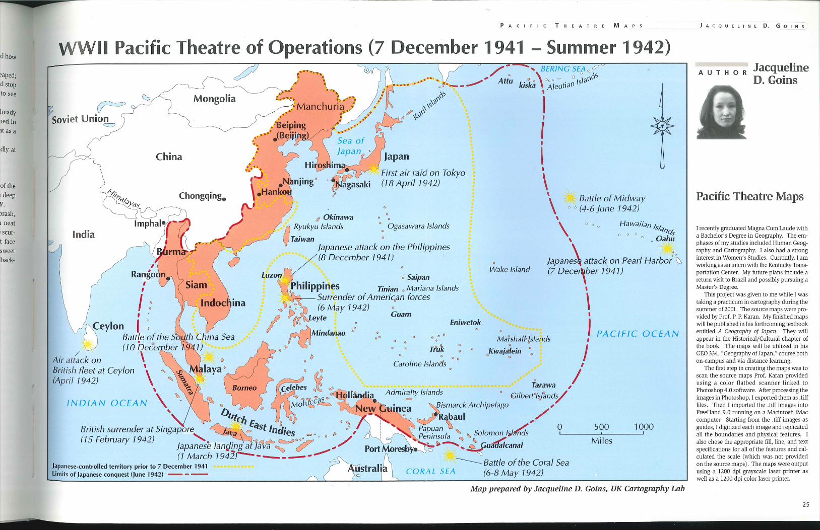
WWII Pacific Theatre of Operations (7 December 1941 -Summer 1942)
Soviet Uni~7 Mongolia
China
Chongqing.
India
Japanese-controlled territory prior to 7 December 1941 Limits of Japanese conquest (June 1942) - - -
500 1000
Miles
Map prepared by Jacqueline D. Goins, UK Cartography Lab
J A C Q U E L I N E D. G 0 1 N S
AUTHOR Jacqueline D. Goins
Pacific Theatre Maps
I recently graduated Magna Cum Laude with a Bachelor's Degree in Geography. The emphases of my studies included Human Geography and Cartography. I also had a strong interest in Women's Studies. Currently, I am working as an intern with the Kentucky Transportation Center. My future plans include a return visit to Brazil and possibly pursuing a Master's Degree.
This project was given to me while I was taking a practicum in cartography during the summer of 2001. The source maps were provided by Prof. P. P. Karan. My finished maps will be published in his forthcoming textbook entitled A Geography of Japan. They will appear in the Historical/Cultural chapter of the book. The maps will be utilized in his GEO 334, "Geography of Japan," course both on-campus and via distance learning.
The first step in creating the maps was to scan the source maps Prof. Karan provided using a color flatbed scanner linked to Photoshop 4.0 software. After processing tl1e images in Photoshop, I exported them as . tiff files. Then I imported the .tiff images into FreeHand 9.0 running on a Macintosh iMac computer. Starting from the .tiff images as guides, I digitized each image and replicated all the boundaries and physical features. I also chose the appropriate fill, line, and text specifications for all of the features and calculated the scale (which was not provided on the source maps). The maps were output using a 1200 dpi grayscale laser printer as well as a 1200 dpi color laser printer.
25
rf,
Mentor: P. P. Karan, Professor, Geography
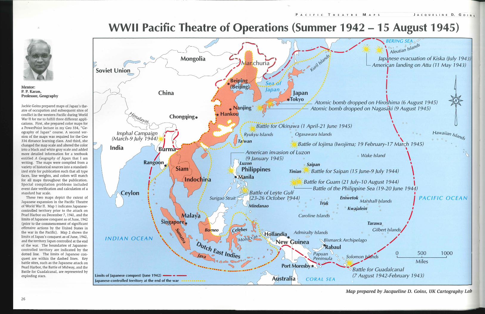
Jackie Goins prepared maps of Japan's theatre of occupation and subsequent sites of conflict in the western Pacific during World War II for me to fulfill three different applications. First, she prepared color maps for a PowerPoint lecture in my Geo 334, "Geography of Japan" course. A second version of the maps was required for the Geo 334 distance learning class. And third, she changed the map scale and altered the color into a black and white gray scale and added more detailed information for a textbook entitled A Geography of Japan that I am writing. The maps were compiled from a variety of historical sources into a standardized style for publication such that all type faces, line weights, and colors will match for all maps throughout the publication. Special compilation problems included event date verification and calculation of a standard bar scale.
These two maps depict the extent of Japanese expansion in the Pacific Theatre of World War II. Map 1 indicates Japanesecontrolled territory prior to the attack on Pearl Harbor on December 7, 1941, and the limits of Japanese conquest as of June, 1942 (prior to the commencement of significant offensive actions by the United States in the war in the Pacific). Map 2 shows the limits of Japan's conquest as of June, 1942, and the territory Japan controlled at the end of the war. The boundaries of Japanesecontrolled territory are indicated by the dotted line. The limits of Japanese conquest are within the dashed lines. Key
. battle sites, such as the Japanese attack on Pearl Harbor, the Battle of Midway, and the Battle for Guadalcanal, are represented by exploding stars.
26
- ---- -- ---------------~---------------------------------------------------------------------
PACIFIC THEATRE MAPS J A C Q U E L I N E D. G 0 I N s
WWII Pacific Theatre of Operations (Summer 1942 15 August 1945)
~ Mongolia
Soviet Union ~
China
Chongqing e
India
ina
, aO , __ , /
~ BERING SEA oc? ' o os r 'ol 0 \ C>o 0 "' 0 ° \s\3(1
- \ A/eut1an L }ap1nese evacuation of Kiska Uuly 1943) Ameri, an landing on Attu (11 May 1943)
I
I I
~----- Atomic bomb dropped on Hiro, hima (6 August 1945) +----=--------- Atomic bomb dropped on Nagasaki (9 August 1945)
\ \ 0 0
\ ' 0
' Battle for Okinawa (1 April-21 june 1945) ~? 00 0
0 0 0
0 Ryukyu Islands o Ogasawara Islands Ta.iwan a ,
\
\ Hawaiian t ., s,a17
0 0 0 0,5-0
. Battle of lojima (/wojima; 19 February-17 March 1945) \
American invasion of Luzon \ o Wake Island
(9 january 1945) o
Cl
0 0
~
zon o Saipan ' hilippines Tinian o,' Battle for Saipan (15 }une-9 july 1944) \ nil a I o ,
"'\)':: dP ' . Battle for Guam (21 }uly-1 0 August 1944) \
I J)llr~... Battle of the Philippine Sea (19-20 june 1944) ull(j ~ Battle of Lef te Gulf 1
Surigao Strait (23-26 Ocfober t944~ o o o o Eniwetok ~arshalr 's/ands J PACIFIC 0 C E AN o Trill< 6
'V () Mindanao o o o o : o Kwajaleitf oo I
Limits of Japanese conquest (June 1942) - - -Japanese-controlled territory at the end of the war
oD o Oo o o I Caroline Is/antis
~J o Tarawa 1
J~ Gilb;rt Islands/ Admiralty Islands o o o o ,
= ~smarck Archipelago o /
~abaul /' Papuan D ~ , 0 500 1 000 Pen i nsu Ia ~ Solomon j;Jtfhds ~--------'-------~
S:> 11. ' ' M'l "" ~ .... ~ __, 1 es ~ ~-··'
SJ Battle for Guadalcanal
=" 0 [)
CORAL SEA (7 August 1942-February 1943)
Map prepared by Jacqueline D. Goins, UK Cartography Lab