Embed Size (px)
Citation preview
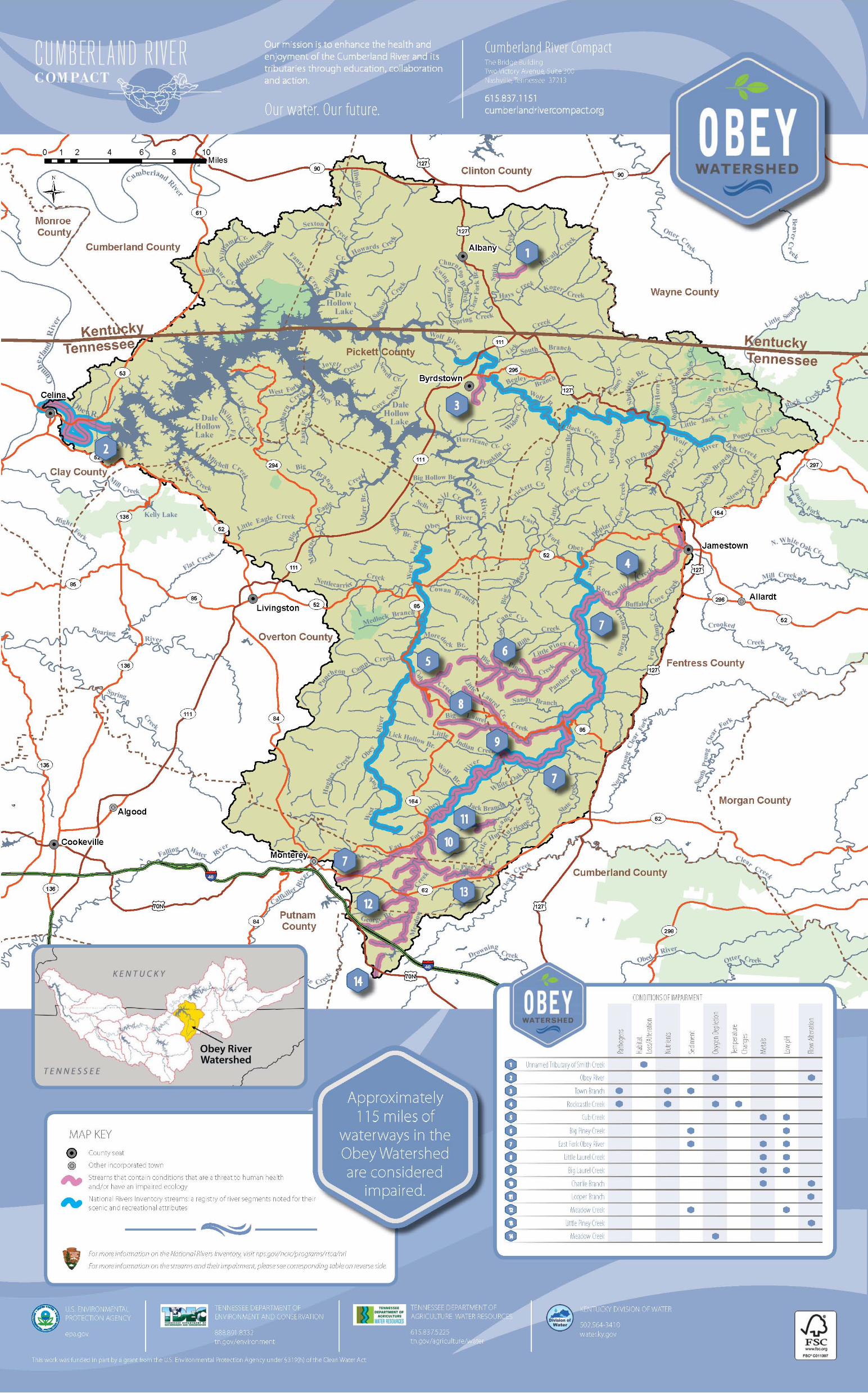
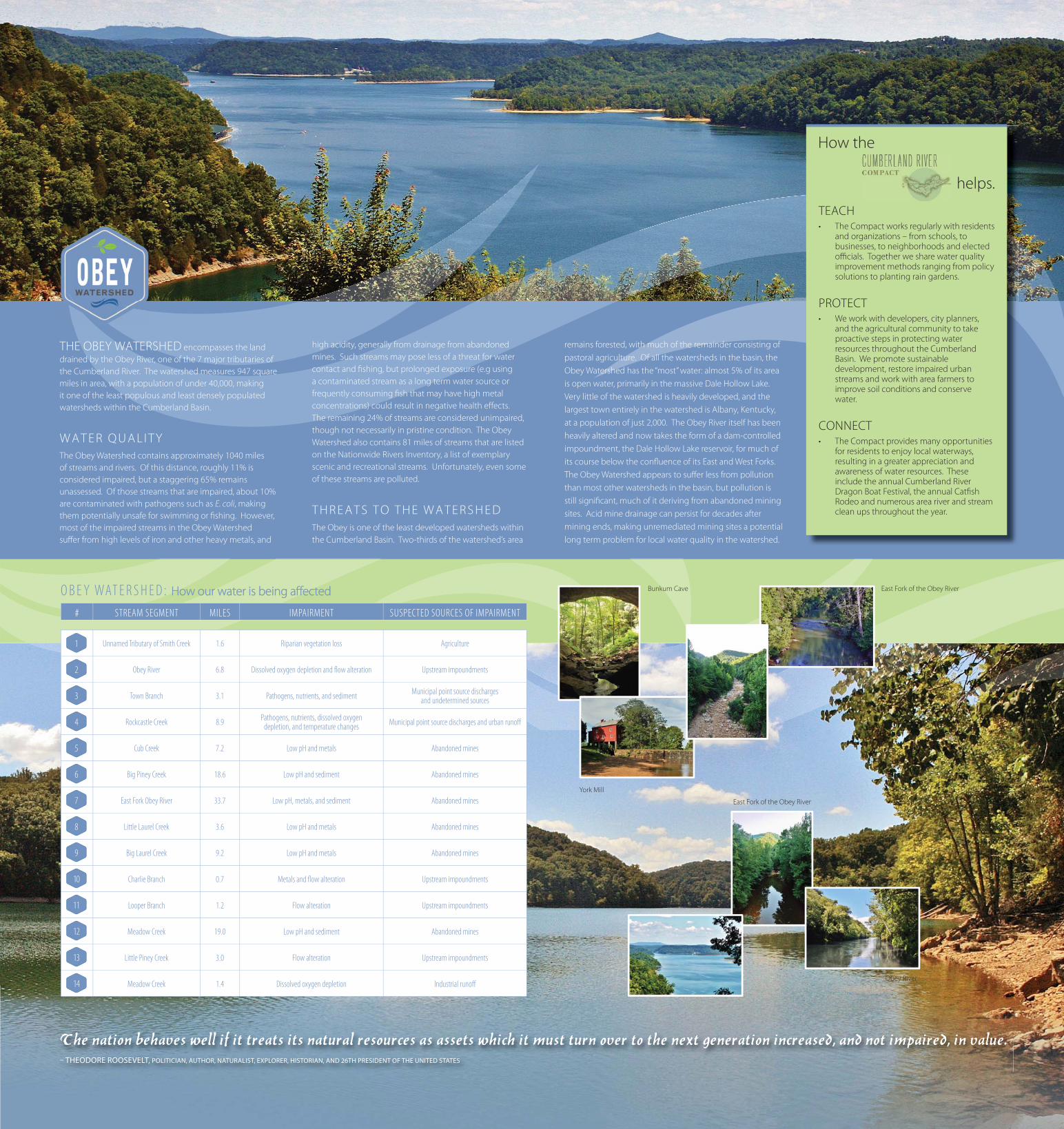
#STREAM SEGMENTMILESIMPAIRMENTSUSPECTED SOURCES OF IMPAIRMENT
Unnamed Tributary of Smith Creek1.6Riparian vegetation lossAgriculture
Obey River6.8Dissolved oxygen depletion and fl ow alterationUpstream impoundments
Town Branch3.1Pathogens, nutrients, and sedimentMunicipal point source discharges
and undetermined sources
Rockcastle Creek8.9Pathogens, nutrients, dissolved oxygen
depletion, and temperature changesMunicipal point source discharges and urban runoff
Cub Creek7.2Low pH and metalsAbandoned mines
Big Piney Creek18.6Low pH and sedimentAbandoned mines
East Fork Obey River33.7Low pH, metals, and sedimentAbandoned mines
Little Laurel Creek3.6Low pH and metalsAbandoned mines
Big Laurel Creek9.2Low pH and metalsAbandoned mines
Charlie Branch0.7Metals and fl ow alterationUpstream impoundments
Looper Branch1.2Flow alterationUpstream impoundments
Meadow Creek19.0Low pH and sedimentAbandoned mines
Little Piney Creek3.0Flow alterationUpstream impoundments
Meadow Creek1.4Dissolved oxygen depletionIndustrial runoff
OBEY WATERSHED: How our water is being aff ected How our water is being aff ected
THE OBEY WATERSHED encompasses the land
drained by the Obey River, one of the 7 major tributaries of
the Cumberland River. The watershed measures 947 square
miles in area, with a population of under 40,000, making
it one of the least populous and least densely populated
watersheds within the Cumberland Basin.
WATER QUALITY
The Obey Watershed contains approximately 1040 miles
of streams and rivers. Of this distance, roughly 11% is
considered impaired, but a staggering 65% remains
unassessed. Of those streams that are impaired, about 10%
are contaminated with pathogens such as E. coli, making
them potentially unsafe for swimming or fi shing. However,
most of the impaired streams in the Obey Watershed
suff er from high levels of iron and other heavy metals, and
high acidity, generally from drainage from abandoned
mines. Such streams may pose less of a threat for water
contact and fi shing, but prolonged exposure (e.g using
a contaminated stream as a long term water source or
frequently consuming fi sh that may have high metal
concentrations) could result in negative health eff ects.
The remaining 24% of streams are considered unimpaired,
though not necessarily in pristine condition. The Obey
Watershed also contains 81 miles of streams that are listed
on the Nationwide Rivers Inventory, a list of exemplary
scenic and recreational streams. Unfortunately, even some
of these streams are polluted.
THREATS TO THE WATERSHED
The Obey is one of the least developed watersheds within
the Cumberland Basin. Two-thirds of the watershed’s area
remains forested, with much of the remainder consisting of
pastoral agriculture. Of all the watersheds in the basin, the
Obey Watershed has the “most” water: almost 5% of its area
is open water, primarily in the massive Dale Hollow Lake.
Very little of the watershed is heavily developed, and the
largest town entirely in the watershed is Albany, Kentucky,
at a population of just 2,000. The Obey River itself has been
heavily altered and now takes the form of a dam-controlled
impoundment, the Dale Hollow Lake reservoir, for much of
its course below the confl uence of its East and West Forks.
The Obey Watershed appears to suff er less from pollution
than most other watersheds in the basin, but pollution is
still signifi cant, much of it deriving from abandoned mining
sites. Acid mine drainage can persist for decades after
mining ends, making unremediated mining sites a potential
long term problem for local water quality in the watershed.
TEACH• The Compact works regularly with residents
and organizations – from schools, to businesses, to neighborhoods and elected offi cials. Together we share water quality improvement methods ranging from policy solutions to planting rain gardens.
PROTECT• We work with developers, city planners,
and the agricultural community to take proactive steps in protecting water resources throughout the Cumberland Basin. We promote sustainable development, restore impaired urban streams and work with area farmers to improve soil conditions and conserve water.
CONNECT• The Compact provides many opportunities
for residents to enjoy local waterways, resulting in a greater appreciation and awareness of water resources. These include the annual Cumberland River Dragon Boat Festival, the annual Catfi sh Rodeo and numerous area river and stream clean ups throughout the year.
helps.
How the
York Mill
East Fork of the Obey River
Dale Hollow Lake
Obey River
East Fork of the Obey River
Bunkum Cave
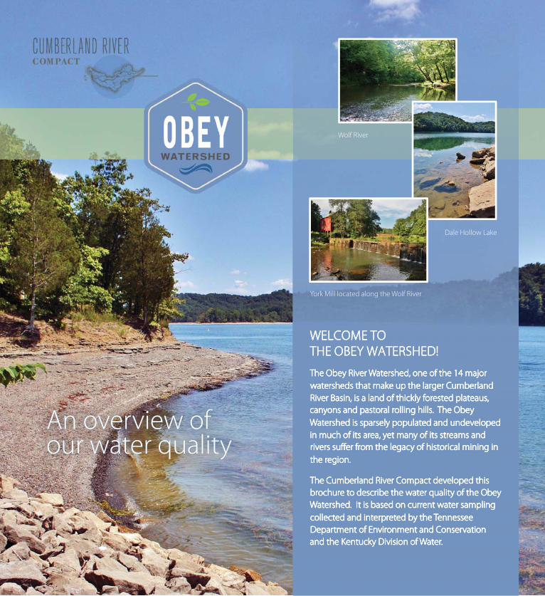
WELCOME TO WELCOME TO
THE OBEY WATERSHED!THE OBEY WATERSHED!
The Obey River Watershed, one of the 14 majorThe Obey River Watershed, one of the 14 major
watersheds that make up the larger Cumberlandwatersheds that make up the larger Cumberland
River Basin, is a land of thickly forested plateaus,River Basin, is a land of thickly forested plateaus,
canyons and pastoral rolling hills. The Obeycanyons and pastoral rolling hills. The Obey
Watershed is sparsely populated and undevelopedWatershed is sparsely populated and undeveloped
in much of its area, yet many of its streams andin much of its area, yet many of its streams and
rivers suff er from the legacy of historical mining in rivers suff er from the legacy of historical mining in
the region.the region.
The Cumberland River Compact developed this The Cumberland River Compact developed this
brochure to describe the water quality of the Obeybrochure to describe the water quality of the Obey
Watershed. It is based on current water sampling Watershed. It is based on current water sampling
collected and interpreted by the Tennesseecollected and interpreted by the Tennessee
Department of Environment and ConservationDepartment of Environment and Conservation
and the Kentucky Division of Water.and the Kentucky Division of Water.
What can I do to What can I do to keep my streams keep my streams and rivers clean?and rivers clean?
• Leave a 35’ to 100’ no mow zone between streams and
activity that disturbs, compacts, or removes soil.
• Harvest rainwater from rooftops using rain barrels or
larger cisterns.
• Keep livestock fenced away from streams and rivers.
• Don’t pour toxic household chemicals down the drain;
take them to a hazardous waste center.
• Use hardy plants that require little or no watering,
fertilizers, or pesticides in your yard.
• Do not over apply fertilizers. Consider using organic or
slow release fertilizers instead.
• Recycle yard waste in a compost pile and use a
mulching mower.
• Use pervious surfaces like wood, brick or gravel for
decks and walkways; this allows rain to soak in and not
run off .
• Never pour used oil or antifreeze into the storm drain
or the street.
• Pick up after your dog, and dispose of the waste in the
toilet or the trash.
• Drive less – walk or bike; many pollutants in our waters
come from car exhaust and car leaks.
• Join watershed clean-up eff orts and restoration
activities.
• Encourage greenways, conservation easements, and
other practices that protect the land around our rivers
and streams.
• Become a member of the Cumberland River Compact
and visit www.cumberlandrivercompact.org often to
keep up-to-date.
An overview of An overview of our water qualityour water quality
Wolf River
Dale Hollow Lake
York Mill located along the Wolf River
TW
O V
ICT
OR
Y A
VE
NU
E, S
UIT
E 3
00
|
NA
SH
VIL
LE, T
EN
NE
SS
EE
37
21
3
# STREAM SEGMENT MILES IMPAIRMENT SUSPECTED SOURCES OF IMPAIRMENT
Unnamed Tributary of Smith Creek 1.6 Riparian vegetation loss Agriculture
Obey River 6.8 Dissolved oxygen depletion and fl ow alteration Upstream impoundments
Town Branch 3.1 Pathogens, nutrients, and sedimentMunicipal point source discharges
and undetermined sources
Rockcastle Creek 8.9Pathogens, nutrients, dissolved oxygen
depletion, and temperature changesMunicipal point source discharges and urban runoff
Cub Creek 7.2 Low pH and metals Abandoned mines
Big Piney Creek 18.6 Low pH and sediment Abandoned mines
East Fork Obey River 33.7 Low pH, metals, and sediment Abandoned mines
Little Laurel Creek 3.6 Low pH and metals Abandoned mines
Big Laurel Creek 9.2 Low pH and metals Abandoned mines
Charlie Branch 0.7 Metals and fl ow alteration Upstream impoundments
Looper Branch 1.2 Flow alteration Upstream impoundments
Meadow Creek 19.0 Low pH and sediment Abandoned mines
Little Piney Creek 3.0 Flow alteration Upstream impoundments
Meadow Creek 1.4 Dissolved oxygen depletion Industrial runoff
O B E Y WAT E R S H E D : How our water is being aff ectedHow our water is being aff ected
THE OBEY WATERSHED encompasses the land
drained by the Obey River, one of the 7 major tributaries of
the Cumberland River. The watershed measures 947 square
miles in area, with a population of under 40,000, making
it one of the least populous and least densely populated
watersheds within the Cumberland Basin.
W A T E R Q U A L I T Y
The Obey Watershed contains approximately 1040 miles
of streams and rivers. Of this distance, roughly 11% is
considered impaired, but a staggering 65% remains
unassessed. Of those streams that are impaired, about 10%
are contaminated with pathogens such as E. coli, making
them potentially unsafe for swimming or fi shing. However,
most of the impaired streams in the Obey Watershed
suff er from high levels of iron and other heavy metals, and
high acidity, generally from drainage from abandoned
mines. Such streams may pose less of a threat for water
contact and fi shing, but prolonged exposure (e.g using
a contaminated stream as a long term water source or
frequently consuming fi sh that may have high metal
concentrations) could result in negative health eff ects.
The remaining 24% of streams are considered unimpaired,
though not necessarily in pristine condition. The Obey
Watershed also contains 81 miles of streams that are listed
on the Nationwide Rivers Inventory, a list of exemplary
scenic and recreational streams. Unfortunately, even some
of these streams are polluted.
T H R E A T S T O T H E W A T E R S H E D
The Obey is one of the least developed watersheds within
the Cumberland Basin. Two-thirds of the watershed’s area
remains forested, with much of the remainder consisting of
pastoral agriculture. Of all the watersheds in the basin, the
Obey Watershed has the “most” water: almost 5% of its area
is open water, primarily in the massive Dale Hollow Lake.
Very little of the watershed is heavily developed, and the
largest town entirely in the watershed is Albany, Kentucky,
at a population of just 2,000. The Obey River itself has been
heavily altered and now takes the form of a dam-controlled
impoundment, the Dale Hollow Lake reservoir, for much of
its course below the confl uence of its East and West Forks.
The Obey Watershed appears to suff er less from pollution
than most other watersheds in the basin, but pollution is
still signifi cant, much of it deriving from abandoned mining
sites. Acid mine drainage can persist for decades after
mining ends, making unremediated mining sites a potential
long term problem for local water quality in the watershed.
TEACH• The Compact works regularly with residents
and organizations – from schools, to businesses, to neighborhoods and elected offi cials. Together we share water quality improvement methods ranging from policy solutions to planting rain gardens.
PROTECT• We work with developers, city planners,
and the agricultural community to take proactive steps in protecting water resources throughout the Cumberland Basin. We promote sustainable development, restore impaired urban streams and work with area farmers to improve soil conditions and conserve water.
CONNECT• The Compact provides many opportunities
for residents to enjoy local waterways, resulting in a greater appreciation and awareness of water resources. These include the annual Cumberland River Dragon Boat Festival, the annual Catfi sh Rodeo and numerous area river and stream clean ups throughout the year.
helps.
How the
York Mill
East Fork of the Obey River
Dale Hollow Lake
Obey River
East Fork of the Obey River
Bunkum Cave
WELCOME TO WELCOME TO
THEOBEYWATERSHED! THEOBEYWATERSHED!
The Obey River Watershed, one of the 14 major The Obey River Watershed, one of the 14 major
watersheds that make up the larger Cumberland watersheds that make up the larger Cumberland
River Basin, is a land of thickly forested plateaus, River Basin, is a land of thickly forested plateaus,
canyons andpastoral rollinghills. The Obey canyons andpastoral rollinghills. The Obey
Watershedis sparsely populatedandundeveloped Watershedis sparsely populatedandundeveloped
in muchof its area, yet many of its streams and in muchof its area, yet many of its streams and
rivers suff er from the legacy of historical mining in rivers suff er from the legacy of historical mining in
the region. the region.
The Cumberland River Compact developed this The Cumberland River Compact developed this
brochure to describe the water quality of the Obey brochure to describe the water quality of the Obey
Watershed.It is based on current water sampling Watershed.It is based on current water sampling
collected and interpreted by the Tennessee collected and interpreted by the Tennessee
Department of Environment and Conservation Department of Environment and Conservation
and the Kentucky Division of Water. and the Kentucky Division of Water.
What can I do to What can I do to keep my streams keep my streams and rivers clean? and rivers clean?
• Leave a 35’ to 100’ no mow zone between streams and
activity that disturbs, compacts, or removes soil.
• Harvest rainwater from rooftops using rain barrels or
larger cisterns.
• Keep livestock fenced away from streams and rivers.
• Don’t pour toxic household chemicals down the drain;
take them to a hazardous waste center.
• Use hardy plants that require little or no watering,
fertilizers, or pesticides in your yard.
• Do not over apply fertilizers. Consider using organic or
slow release fertilizers instead.
• Recycle yard waste in a compost pile and use a
mulching mower.
• Use pervious surfaces like wood, brick or gravel for
decks and walkways; this allows rain to soak in and not
run off .
• Never pour used oil or antifreeze into the storm drain
or the street.
• Pick up after your dog, and dispose of the waste in the
toilet or the trash.
• Drive less – walk or bike; many pollutants in our waters
come from car exhaust and car leaks.
• Join watershed clean-up eff orts and restoration
activities.
• Encourage greenways, conservation easements, and
other practices that protect the land around our rivers
and streams.
• Become a member of the Cumberland River Compact
and visit www.cumberlandrivercompact.org often to
keep up-to-date.
An overview of An overview of our water quality our water quality
Wolf River
Dale Hollow Lake
York Mill located along the Wolf River
TW
O V
ICT
OR
Y AV
EN
UE, S
UIT
E 30
0 | N
AS
HV
ILL
E, TE
NN
ES
SE
E 37
21
3