Embed Size (px)
Citation preview
copyright © 2010 Starpath Online Navigation Course, www.starpath.com
Wrinkles in Practical ECSThe use of ECS (Electronic Chart Systems) is fundamental to modern navigation, just as much as it is fundamental that we know how to navigate without it. The term means con-necting a GPS to an echart display and navigating by moving map technology. An icon representing the boat shows where you are at all times on an electronic version of a nautical chart. You can view the chart in dedicated echart plotters or in the chart display of a GPS unit, or in your smart phone, but the most functionality comes with viewing the charts in a PC program dedicated to the task, running in a laptop.
The acronym ECDIS (Electronic Chart Display and Informa-tion System) means essentially the same thing, but it refers to the official system of the International Maritime Organi-zation (IMO) that has strict standards on the types of charts, the hardware, and the format of the display. Ships must use ECDIS; yachts can use anything they like and call it ECS.
The types of GPS units and the types of echart display devices we can choose from are changing rapidly. A blue tooth GPS running one of several excellent programs in a small laptop offers excellent mobility if you sail on different boats. The full package including a few custom echarts is around $900 or so.
Some one dozen years ago, when we were asked “Should I take a computer along on my cruise?” the answer was if you need one for your work and entertainment, then Yes, but otherwise the hassle might not be worth the reward in navigation and communication. Now if we get the same question, the answer is No, you should not take a computer along, you should take two. Build two of these laptops with
all of your navigation, communications, and weather soft-ware installed and running, so you have a mirror image back up. It takes some tweaking to get a PC dependably commu-nicating with several external devices and then sharing this input with several programs running at once, so there is no point in doing it twice.
The hassle of protecting a PC and its even more vulnerable attachments when underway in the ocean has not changed at all over the years, but the reward you get from the system is so very much higher. For now we are discussing just navi-gation, but modern high seas communications and weather data gathering and analysis requires a computer. Needless to say, there are sailors who successfully sail around the world without these aids, but in doing so they give up tremendous resources for safety and efficiency.
ECS is perhaps more immediately important on inland and coastal waters, but even in the ocean the same basic proce-dures and advantages apply. Here is a brief outline, which we might call…
How to Navigate TodayStep 1. Start with waypoints. Every voyage, 2 miles or 2,000 miles, proceeds by waypoints. Spend the time to choose the best way to go, taking all factors into account.
Generally we do this selection with the echart program, zoomed out to see an overview of most of the route. Use the
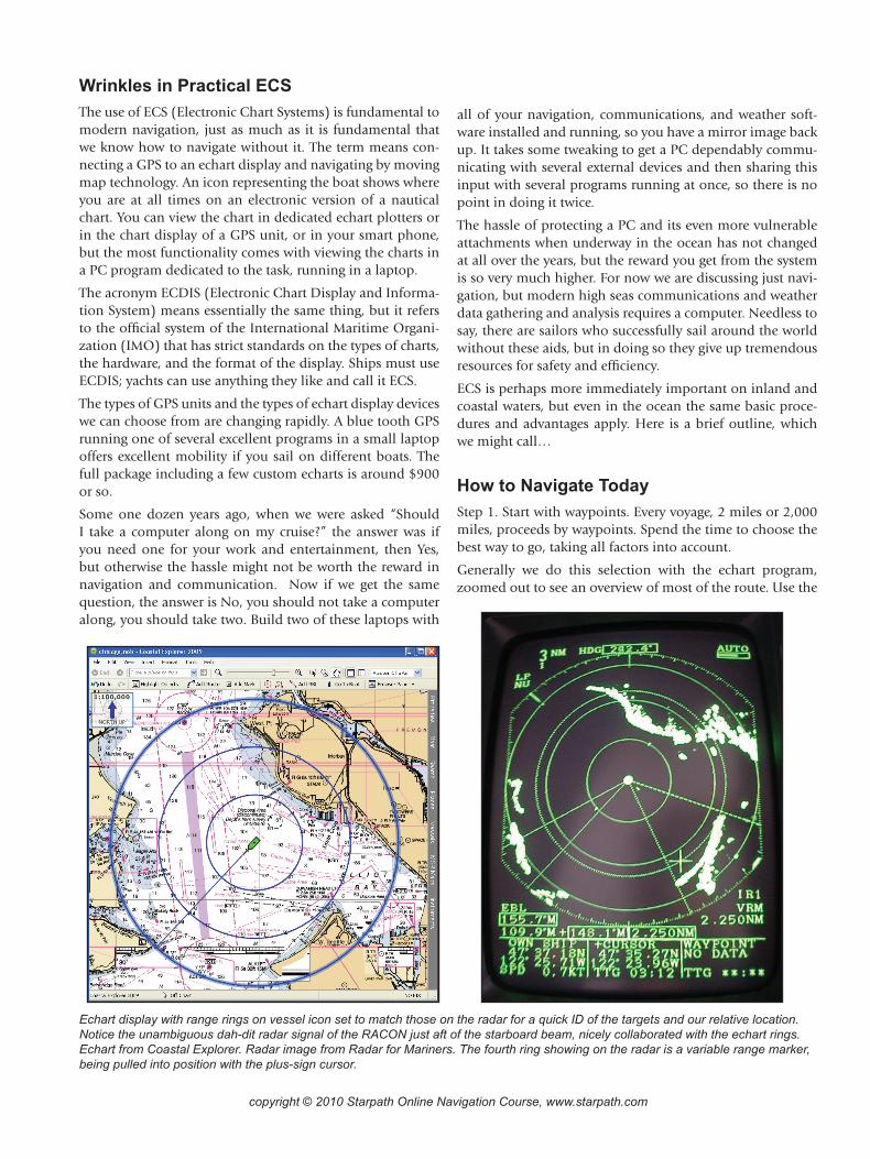
Echart display with range rings on vessel icon set to match those on the radar for a quick ID of the targets and our relative location. Notice the unambiguous dah-dit radar signal of the RACON just aft of the starboard beam, nicely collaborated with the echart rings. Echart from Coastal Explorer. Radar image from Radar for Mariners. The fourth ring showing on the radar is a variable range marker, being pulled into position with the plus-sign cursor.
copyright © 2010 Starpath Online Navigation Course, www.starpath.com
route tool to quickly set the approximate location of each of the main turning points, then zoom in to drag the way-points to the best position, and add more as needed. Then give them each a real name and lock their position. The real name should be preceded by a number, so you can order them, and know where you are along a route. Just numbers or just names is not good.
Then make a printed voyage plan table or spread sheet with the names and lat, lon of each point, and the course and distance between them. Also add estimated speeds for each leg of the route. Most echart programs will format this data for you and figure the times at each way point and then export or print this record directly for you. Some-how we should end up with a printed record. We are deal-ing with computers after all, and we don’t want to do this twice.
For inland waters, the way-points are best when in view of a prominent radar target, or other way to uniquely identify the location by visual means. In broad terms, it is the job of a good navigation course to teach you how to choose these waypoints. It is the key step in the navigation.
If you are planning for a yacht race, or if any part of your cruising voy-age calls for crucial navigation, then I would immediately export these waypoints from the PC program into your hand-held GPS. It takes some instructions manual reading to learn the process of transferring waypoints, routes, or actual tracts between PC and hand-held, but well worth it. If anything goes wrong at a crucial mo-ment, you will then be ready instantly with a solution. As navigator, you can also be monitoring progress along the route as you sit on deck when you have your hand-held programmed.
Then the job is to follow the way-points. If you cut corners or skip waypoints then the set up was wrong. There will be discoveries along the way that call for waypoint changes,
but if so, change the waypoint and then sail the waypoints you now have. Remember, you might be sailing the route again someday, so you can record it properly now for the next time. In a sense, if you do not follow the waypoints you are not navigating; you are just sailing there.
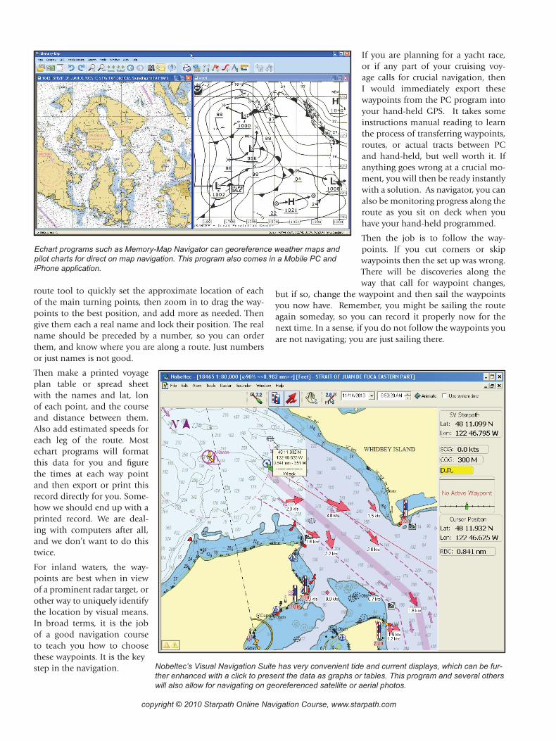
Echart programs such as Memory-Map Navigator can georeference weather maps and pilot charts for direct on map navigation. This program also comes in a Mobile PC and iPhone application.
Nobeltec’s Visual Navigation Suite has very convenient tide and current displays, which can be fur-ther enhanced with a click to present the data as graphs or tables. This program and several others will also allow for navigating on georeferenced satellite or aerial photos.
copyright © 2010 Starpath Online Navigation Course, www.starpath.com
Step 2. Successive waypoints define the line between them. Our job is to stay on that line to the very best we can. When under sail, we will have obvious limitations on our route, but we still must keep that line in mind at all times. Let’s look at the simplest case first, under power or reaching so we have control over our heading.
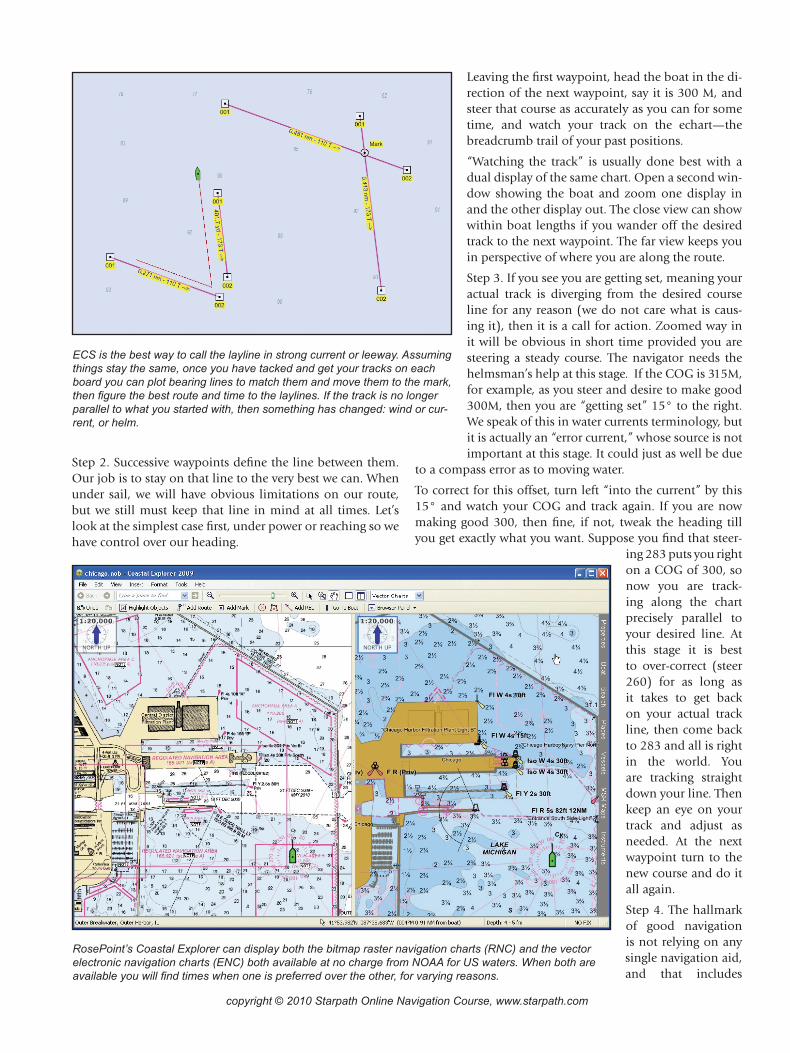
ECS is the best way to call the layline in strong current or leeway. Assuming things stay the same, once you have tacked and get your tracks on each board you can plot bearing lines to match them and move them to the mark, then figure the best route and time to the laylines. If the track is no longer parallel to what you started with, then something has changed: wind or cur-rent, or helm.
Leaving the first waypoint, head the boat in the di-rection of the next waypoint, say it is 300 M, and steer that course as accurately as you can for some time, and watch your track on the echart—the breadcrumb trail of your past positions.
“Watching the track” is usually done best with a dual display of the same chart. Open a second win-dow showing the boat and zoom one display in and the other display out. The close view can show within boat lengths if you wander off the desired track to the next waypoint. The far view keeps you in perspective of where you are along the route.
Step 3. If you see you are getting set, meaning your actual track is diverging from the desired course line for any reason (we do not care what is caus-ing it), then it is a call for action. Zoomed way in it will be obvious in short time provided you are steering a steady course. The navigator needs the helmsman’s help at this stage. If the COG is 315M, for example, as you steer and desire to make good 300M, then you are “getting set” 15° to the right. We speak of this in water currents terminology, but it is actually an “error current,” whose source is not important at this stage. It could just as well be due
to a compass error as to moving water.
To correct for this offset, turn left “into the current” by this 15° and watch your COG and track again. If you are now making good 300, then fine, if not, tweak the heading till you get exactly what you want. Suppose you find that steer-
ing 283 puts you right on a COG of 300, so now you are track-ing along the chart precisely parallel to your desired line. At this stage it is best to over-correct (steer 260) for as long as it takes to get back on your actual track line, then come back to 283 and all is right in the world. You are tracking straight down your line. Then keep an eye on your track and adjust as needed. At the next waypoint turn to the new course and do it all again.
Step 4. The hallmark of good navigation is not relying on any single navigation aid, and that includes
RosePoint’s Coastal Explorer can display both the bitmap raster navigation charts (RNC) and the vector electronic navigation charts (ENC) both available at no charge from NOAA for US waters. When both are available you will find times when one is preferred over the other, for varying reasons.
copyright © 2010 Starpath Online Navigation Course, www.starpath.com
GPS. A versatile ECS can implement quick checks of your GPS position and rate of travel. Radar and depth sounder are often the first instruments to check.
Using raster echarts (graphic images of paper charts, called RNC), you can read or interpolate the depth at your position from the printed soundings, correct for tide height, and com-pare it with your depth sounder. Or easier still, note when the echart display shows you crossing a prominent ledge within soundings, and watch to see the depth sounder confirm the crossing. This method is less sensitive to your sounder’s cali-bration. Vector echarts on the other hand, since they are ren-dered images of digitized chart data (called ENC), can actu-ally compute and display the charted depth at your location to compare with your depth sounder. Many echart programs include digital tide predictions, which expedite the process.
Several echart programs allow the user to set multiple range rings on the vessel icon. This is a very handy feature. You can set these range rings to match the range rings on your pres-ent radar display and also set the display mode (head-up or north-up) to match, and then use the echart display for an instant interpretation of the radar screen. This comparison is one of the best ways possible to confirm your position—or when disoriented, it is a quick way to regain what is formally
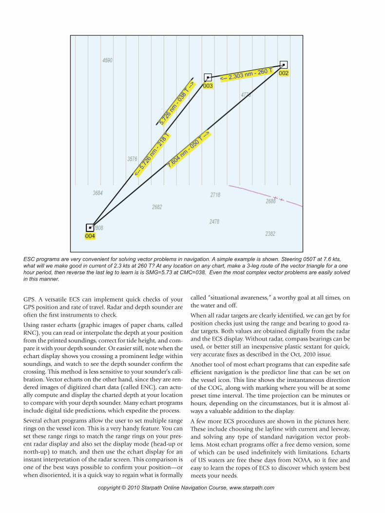
ESC programs are very convenient for solving vector problems in navigation. A simple example is shown. Steering 050T at 7.6 kts, what will we make good in current of 2.3 kts at 260 T? At any location on any chart, make a 3-leg route of the vector triangle for a one hour period, then reverse the last leg to learn is is SMG=5.73 at CMC=038. Even the most complex vector problems are easily solved in this manner.
called “situational awareness,” a worthy goal at all times, on the water and off.
When all radar targets are clearly identified, we can get by for position checks just using the range and bearing to good ra-dar targets. Both values are obtained digitally from the radar and the ECS display. Without radar, compass bearings can be used, or better still an inexpensive plastic sextant for quick, very accurate fixes as described in the Oct, 2010 issue.
Another tool of most echart programs that can expedite safe efficient navigation is the predictor line that can be set on the vessel icon. This line shows the instantaneous direction of the COG, along with marking where you will be at some preset time interval. The time projection can be minutes or hours, depending on the circumstances, but it is almost al-ways a valuable addition to the display.
A few more ECS procedures are shown in the pictures here. These include choosing the layline with current and leeway, and solving any type of standard navigation vector prob-lems. Most echart programs offer a free demo version, some of which can be used indefinitely with limitations. Echarts of US waters are free these days from NOAA, so it free and easy to learn the ropes of ECS to discover which system best meets your needs.

copyright © 2010 Starpath Online Navigation Course, www.starpath.com
Step 1. Spot the set. The red line is the course to next mark at 300M. Knotmeter speed is 6 kts. A current of about 2 kts is flowing N-NE, causing a set of about 15°. The black line on the vessel icon is the heading line (at 300M), the blue line shows the COG (at 315M) and predicted location of the boat in 2 minutes. Notice that in less than 2 minutes we have a good idea of our set when zoomed in to this scale.
Step 1
Step 3
Step 2
Step 4
Step 2. Correct the course and check the results. After turning into the current by 15° (to heading 285M), we find we need a bit more correction and 283 M tracks parallel to the desired course with COG = 300M.
Step 3. Over correct (heading = 260M) to get back on desired track. Making good the right course is not enough. We want to make good the right course in the right place.
Step 4. Once back on the track, we can turn to the proper course that we know corrects for current, namely 283M, and we are now tracking right down the line as desired. It is easy to do. We should not except less.