Embed Size (px)
Citation preview

WRIA 14 Watershed Management PlanKennedy–Goldsborough Watershed
Final Unadopted Draft / May 2006
Prepared for the WRIA 14 Planning Unit under Grant G0000107 by Plateau Technical Communication Services
Not approved or adopted by the WRIA 14 Planning Unit

Page 1
Table of Contents INTRODUCTION........................................................................................... 2
Watershed Planning in WRIA 14 ......................................................... 2 Disclaimers ........................................................................................... 2
CHARACTERISTICS OF WRIA 14 ............................................................... 3 Physiography & Climate....................................................................... 3 Hydrogeology ....................................................................................... 4
CURRENT CONDITIONS .............................................................................. 4 Water Quantity...................................................................................... 5
Water Budget .................................................................................. 5 Water Rights Issues......................................................................... 5
Water Quality........................................................................................ 6 Instream Flows...................................................................................... 7 Habitat................................................................................................... 7
RECOMMENDATIONS .................................................................................. 8 Monitoring & Data Analysis................................................................. 8
Key Issues........................................................................................ 8 Recommendations ........................................................................... 9
Sewage Management .......................................................................... 11 Key Issues...................................................................................... 11 Recommendations ......................................................................... 12
Stormwater Management .................................................................... 13 Key Issues...................................................................................... 13 Recommendations ......................................................................... 13
Conservation ....................................................................................... 14 Key Issues...................................................................................... 14 Recommendations ......................................................................... 15
Habitat................................................................................................. 16 Key Issues...................................................................................... 16 Recommendations ......................................................................... 16
Public Education & Outreach ............................................................. 17 Key Issues...................................................................................... 17 Recommendations ......................................................................... 18
Compliance & Enforcement ............................................................... 19 Key Issues...................................................................................... 19 Recommendation........................................................................... 19
Future Planning................................................................................... 19 Key Issues...................................................................................... 19 Recommendations ......................................................................... 20
REFERENCES............................................................................................. 21
WRIA 14 Watershed Management Plan Grant G000107 Final Draft — May 2006

Page 2
Introduction Introduction
Watershed Planning in WRIA 14
Watershed planning is essential to ensure that abundant, clean water con-tinues to be available—not only for growing communities, but also for fish and wildlife. Recognizing this need, the Washington State legislature passed the Watershed Planning Act (Chapter 90.82 RCW) in 1998. This legislation established a process for preparing watershed plans for 62 Wa-ter Resource Inventory Areas (WRIAs), which roughly correspond with physiographic boundaries of drainage basins in Washington. WRIA 14, the Kennedy-Goldsborough watershed, is one of these basins. This largely rural area includes the City of Shelton and lies mostly within Mason County, with an additional 15 percent in Thurston County and less than 1 percent in Grays Harbor County. In accordance with the Watershed Plan-ning Act, several governments initiated watershed planning in WRIA 14:Mason County (the lead entity) Thurston County The Squaxin Island Tribe The City of Shelton Mason County Public Utility District (PUD) No. 1 Port of Shelton State of Washington
Representatives of these governments formed a Planning Unit. Participat-ing organizations include the Washington Department of Ecology (Ecol-ogy), fisheries, the development community, the shellfish industry, envi-ronmental and salmon recovery groups, water providers, the timber indus-try, recreational groups, and citizens, among others. As a result, the WRIA 14 Watershed Management Plan represents a wide range of interests in the local community. Grays Harbor County opted out of the planning process because it contains only a small area within WRIA 14.
This document was prepared for the WRIA 14 Planning Unit. Work was funded by Grant G000107, which was awarded to Mason County by Ecology under the Watershed Planning Act.
Grant G000107 Final Draft — May 2006
Disclaimers This document is the only component of the WRIA 14 planning process that the Planning Unit has approved for formal consideration by participat-ing Counties as outlined in RCW 90.82. Unapproved documents include the Draft WRIA 14 Watershed Management Plan, numerous technical re-ports, and various other products of this planning process. This document is the only product that should be interpreted or used as an approved plan
WRIA 14 Watershed Management Plan Grant G000107 Final Draft — May 2006

Page 3
component; other materials should be considered informational resources that provide a record of the planning process. component; other materials should be considered informational resources that provide a record of the planning process.
This plan only addresses State-issued water rights—not Federal- or Tribal-based rights. It only acknowledges that Tribal rights have not been quanti-fied and that, in most cases, they are likely senior to specific State water rights. Nothing in this plan shall be construed by the State as providing grounds for issuing water rights under provisions related to “overriding consideration of the public interest” per 90.82.130 (4) RCW.
This plan only addresses State-issued water rights—not Federal- or Tribal-based rights. It only acknowledges that Tribal rights have not been quanti-fied and that, in most cases, they are likely senior to specific State water rights. Nothing in this plan shall be construed by the State as providing grounds for issuing water rights under provisions related to “overriding consideration of the public interest” per 90.82.130 (4) RCW.
Nothing in this plan creates an obligation unless funding is available for the specified task. Government members may also prioritize tasks based on available funding and need. Many of these issues will be clarified in Phase IV, when the Planning Unit prepares a detailed implementation plan.
Nothing in this plan creates an obligation unless funding is available for the specified task. Government members may also prioritize tasks based on available funding and need. Many of these issues will be clarified in Phase IV, when the Planning Unit prepares a detailed implementation plan.
Characteristics of WRIA 14 Characteristics of WRIA 14
Physiography & Climate
WRIA 14 is divided into five sub-basins—Case Inlet, Goldsborough, Kennedy, Skookum, and South Shore. However, the South Shore Sub-Basin, which runs along Hood Canal, is considered part of WRIA 16 for watershed planning purposes; consequently, it is covered under the WRIA 16 Watershed Management Plan. The Goldsborough Sub-Basin is the largest of the four covered under this plan. It includes all of Oakland Bay and Hammersley Inlet, as well as the City of Shelton (the only incorpo-rated area in WRIA 14). The Case Inlet Sub-Basin includes Harstine and Squaxin Islands, as well as Case Inlet. The Kennedy Sub-Basin includes parts of Totten and Eld Inlets. The Skookum Sub-Basin is the smallest; it includes Skookum Inlet.Like other parts of south Puget Sound, WRIA 14 features an extensive network of streams that issue from springs, wetlands, small lakes, and sur-face water drainages. These streams empty into shallow bays and inlets. Principal drainages include Cranberry, Goldsborough, Kennedy, Mill, Sherwood, Johns, Deer, and Skookum Creeks. Despite its abundance of creeks, WRIA 14 has no major rivers.
An aquifer is a geo-logic unit that bears significant quantities of water. It often con-sists of unconsoli-dated sediments (such as sand and gravel) or fractured bedrock.
Because of its low elevation, WRIA 14 receives very little snow. How-ever, between 53 and 93 inches of rain falls each year on various parts of
WRIA 14 Watershed Management Plan Grant G000107 Final Draft — May 2006
Grant G000107 Final Draft — May 2006

Page 4
the watershed1. Part of this rain becomes runoff that flows overland into streams and other water bodies. Another portion, however, percolates into the ground to replenish—or “recharge”—the aquifer system.
the watershed1. Part of this rain becomes runoff that flows overland into streams and other water bodies. Another portion, however, percolates into the ground to replenish—or “recharge”—the aquifer system.
Hydrogeology Hydrogeology WRIA 14’s aquifer system consists of layered sediments deposited by gla-ciers that covered the region up until 10,000–14,000 years ago. These sediments cover most of the watershed’s surface except the Black Hills area, which is located in the southwestern portion of the WRIA 14 at the foothills of the Cascades, where a type of volcanic rock known as basalt appears at ground surface. This basalt bedrock also underlies the glacial sediments, forming a hard boundary to the aquifer system. Although most of WRIA 14’s wells tap the glacial sediments, their ability to provide wa-ter supplies depends on several factors. First, the sediments must be thick enough to store significant amounts of water. Thickness varies widely throughout the watershed, from a few feet to a few hundred feet. Second, the sediments must be permeable enough to allow water to move easily through the aquifer. Another important factor in determining where future supplies can be developed is the hydraulic continuity between surface wa-ter and groundwater. Levels of continuity vary across the watershed. In ar-eas of high hydraulic continuity, pumping a well will reduce the flows in a nearby stream, potentially impairing habitat and conditions for fish and wildlife.
WRIA 14’s aquifer system consists of layered sediments deposited by gla-ciers that covered the region up until 10,000–14,000 years ago. These sediments cover most of the watershed’s surface except the Black Hills area, which is located in the southwestern portion of the WRIA 14 at the foothills of the Cascades, where a type of volcanic rock known as basalt appears at ground surface. This basalt bedrock also underlies the glacial sediments, forming a hard boundary to the aquifer system. Although most of WRIA 14’s wells tap the glacial sediments, their ability to provide wa-ter supplies depends on several factors. First, the sediments must be thick enough to store significant amounts of water. Thickness varies widely throughout the watershed, from a few feet to a few hundred feet. Second, the sediments must be permeable enough to allow water to move easily through the aquifer. Another important factor in determining where future supplies can be developed is the hydraulic continuity between surface wa-ter and groundwater. Levels of continuity vary across the watershed. In ar-eas of high hydraulic continuity, pumping a well will reduce the flows in a nearby stream, potentially impairing habitat and conditions for fish and wildlife.
Hydraulic continuity is the degree of connec-tion between two or more aquifers or be-tween an aquifer and a surface water body such as a stream, lake, or wetland.
In some areas, wells may produce a thousand gallons per minute or more; in others, 10 gallons per minute or less. Likewise, in some areas, sedi-ments contain layers of clays and silts, which do not transmit water easily; in other areas, however, a mixture of gravel and sand forms a highly per-meable aquifer layer.
In some areas, wells may produce a thousand gallons per minute or more; in others, 10 gallons per minute or less. Likewise, in some areas, sedi-ments contain layers of clays and silts, which do not transmit water easily; in other areas, however, a mixture of gravel and sand forms a highly per-meable aquifer layer.
Current Conditions Current Conditions The Watershed Planning Act specifies four key elements that Planning Units may consider for their WRIAs: water quantity, water quality, habi-tat, and instream flows. Of these, only the water quantity element is re-quired; however, the WRIA 14 Planning Unit elected to address all four in the watershed plan.
1 Based on PRISM data from University of Oregon
WRIA 14 Watershed Management Plan Grant G000107 Final Draft — May 2006
Grant G000107 Final Draft — May 2006

Page 5
Water Quantity To effectively manage our water supplies, we must understand how much water is available and how much we will need to meet future demands. Most of WRIA 14’s water comes from wells owned by municipal provid-ers, community systems, and individuals. As part of the watershed plan-ning process, a water balance—that is, an equation describing annual rates of inflow and outflow—was used to estimate the amount of water avail-able in this basin2. It is essential to understand that the water balance was developed with preliminary estimates of usage, streamflow, and other pa-rameters. Much more data must be collected before we can really quantify water availability and understand how pumping from WRIA 14’s aquifers will affect streamflows and habitat.
Related Recommendations
Monitoring & Data Analysis (page 7)
Conservation (page 12)
Public Education & Outreach (page 15)
Compliance & En-forcement (page 17)
Water Budget According to this analysis, WRIA 14 receives an estimated 1,360,000 acre-feet per year (AF/yr) of water through rainfall3. About 930,000 AF/yr leaves the watershed via natural processes (creek flow and evapotranspira-tion), not counting the water that flows underground into Puget Sound. Much less water—6,600 AF/yr, according to this analysis—is actually used, suggesting that WRIA 14 has a surplus of about 420,000 AF/yr. However, this number is misleading because many other factors play a role in determining water availability. One is location within the basin; quantities vary significantly from area to area. Another is the impact to streamflows if groundwater supplies are developed in areas of high hy-draulic continuity. Streams are especially vulnerable during the summer and early fall, when flows are at their lowest and demands on groundwater supplies are at their highest (so wells are pumping at their highest capaci-ties). Climate trends, short- and long-term, will also continue to influence water supplies.
Water Rights Issues Washington State requires anyone who diverts surface water or who pumps more than 5,000 gallons per day (gpd) from a well to have either a permit, certificate, or claim. Permits and certificates are valid water rights issued by Ecology and its predecessors since 1917. Claims are based on continuous beneficial use that predates the passage of surface or ground-water laws; however, they are not considered valid water rights unless af-firmed by a court. Claimants must file with Ecology.
2 Details of this water balance appear in the Level I hydrogeologic assessment (Golder, 2003). 3 Level I hydrogeologic assessment (Golder, 2003).
WRIA 14 Watershed Management Plan Grant G000107 Final Draft — May 2006

Page 6
In WRIA 14, over ten times the amount of water used—68,800 AF/yr—has been allocated in groundwater and surface water rights. Most of this water (about 60 percent) is for commercial-industrial uses, and most use occurs within the Goldsborough Sub-Basin. Residential uses comprises about 25 percent of allocations; however, this estimate does not consider exempt wells.
In WRIA 14, over ten times the amount of water used—68,800 AF/yr—has been allocated in groundwater and surface water rights. Most of this water (about 60 percent) is for commercial-industrial uses, and most use occurs within the Goldsborough Sub-Basin. Residential uses comprises about 25 percent of allocations;
Grant G000107 Final Draft — May 2006
however, this estimate does not consider exempt wells.
Surface Water Groundwater Both Use
AF % AF % AF %
Municipal 504 1.7 4034 11.0 4538 7.0
Irrigation 5328 17.7 5363 13.7 10691 15.5
Domestic 579 1.9 9697 24.8 10276 14.9
Commercial-Industrial
22236 74.0 19415 49.7 41651 60.3
Other 1417 4.7 271 0.7 1688 2.4
Total 30064 100.0 38780 100.0 68844 100.0
Of this total amount, about 30,000 AF/yr is from surface water. The re-mainder—nearly 39,000 AF/yr—has been allocated from groundwater. The large discrepancy between allocations and actual use suggests that many permit and certificate holders are not exercising their rights to their fullest.
Two other types of water rights, instream flows and tribal rights, are also important to watershed planning. Instream flows are discussed on page 7. Tribal water rights are reserved whenever federal lands are set aside for Indian reservations. They also support treaty fishing rights. Each water right has a priority date that corresponds at least to the date the reservation was established, if not earlier. These rights precede all others because the Medicine Creek Treaty was signed in 1854. Related
Recommendations
Monitoring & Data Analysis Water Quality (page 7)
Sewage Management (page 8) The quality of water in many of WRIA 14’s streams, lakes, and nearshore
areas has been degraded. Five marine areas, including parts of Oakland Bay and Hammersley Inlet, are on the most recent 303(d) list of impaired waters because of high fecal coliform bacteria and/or low stream tempera-tures. Parts of Oakland Bay and Hammersley Inlet are also closed to shell-fish harvesting because of high fecal coliform concentrations. Much of Oakland Bay is conditionally approved.
Stormwater Man-agement (page 10)
Public Education & Outreach (page 15)
Compliance & En-forcement (page 17)
WRIA 14 Watershed Management Plan Grant G000107 Final Draft — May 2006

Page 7
Likewise, 14 creeks in WRIA 14 have been included on the most recent 303(d) list for fecal coliform, temperature, dissolved oxygen, and/or pH. Water temperatures become elevated in response to a reduction in groundwater inflow to streams, as well as a reduction in shade along stream corridors. Listings and closures have been documented for many years.
Likewise, 14 creeks in WRIA 14 have been included on the most recent 303(d) list for fecal coliform, temperature, dissolved oxygen, and/or pH. Water temperatures become elevated in response to a reduction in groundwater inflow to streams, as well as a reduction in shade along stream corridors. Listings and closures have been documented for many years.
Grant G000107 Final Draft — May 2006
303(d) Constituent (Category 5 - Impaired)
Creeks The 303(d) list is de-veloped by the state every 2 years to fulfill the requirements specified in Section 303(d) of the 1972 Clean Water Act. Its purpose is to identify polluted waters so we can clean them up.
Dissolved Oxygen (3) Kennedy, Pierre, and Schneider
Fecal Coliform (11) Burns, Campbell, Goldsborough, Kennedy, Malaney, Perry, Pierre, Schneider, Shelton, Uncle Johns, and Skookum
pH (2) Burns and Pierre
Temperature (4) Cranberry, Johns, Mill, and Skookum
Water quality has also degraded some lakes. Island Lake is included on the 303(d) list because of concerns about phosphorous. However, the Category 2 status means that water in this lake is not considered impaired.
Other water quality problems include excessive sediment in streams, which creates unfavorable habitat conditions for salmonids. Sediment originating from erosion along roads and streambanks is carried into streams by stormwater runoff.
Instream Flows Instream flow rights are established to maintain or safeguard aquatic biota and fish, and to support recreational and other beneficial uses. Minimum instream flows were set on January 23, 1984. Streamflow data is sparse but indicates that these flow requirements are often unmet. Although the Planning Unit considered how to manage and achieve minimum instream flow values, it made no recommendations on existing administrative flow targets.
Related Recommendations
Habitat Habitat (page 14)
Sewage Management (page 8) WRIA 14’s streams support two species of salmonids—chum and coho—
as well as winter steelhead and coastal cutthroat. These species also use nearshore areas, along with chinook salmon, which have recently been listed under the Endangered Species Act. WRIA 14 is also home to many shellfish species. In addition, many of the water quantity and water quality
Stormwater Man-agement (page 10)
Public Education & Outreach (page 15)
WRIA 14 Watershed Management Plan Grant G000107 Final Draft — May 2006

Page 8
issues addressed here have profound implications for fish and shellfish habitat. The limiting factors analysis conducted for WRIA 14 indicates that salmonid habitat has been degraded by land use practices associated with forest management, removal of large woody debris (LWD), devel-opment, and agriculture4. Other issues include culvert problems, nearshore habitat and riparian degradation, loss of channel complexity, and high sedimentation levels.
issues addressed here have profound implications for fish and shellfish habitat. The limiting factors analysis conducted for WRIA 14 indicates that salmonid habitat has been degraded by land use practices associated with forest management, removal of large woody debris (LWD), devel-opment, and agriculture4. Other issues include culvert problems, nearshore habitat and riparian degradation, loss of channel complexity, and high sedimentation levels.
Recommendations Recommendations Through a collaborative process, the Planning Unit has identified key is-sues in the areas of water quantity, water quality, and habitat. Options
were then researched for addressing these issues through policy and man-agement-based actions. The recommendations presented below are the re-sult of a lengthy process that entailed considering a wide range of options. The Planning Unit developed these recommendations based on their over-all benefit to watershed processes and their feasibility of implementation.Monitoring & Data Analysis The Planning Unit finds that additional information is necessary to effec-tively manage water resources in WRIA 14. Ongoing gathering of water quality and quantity data will achieve several objectives. First, it will help us determine where and how to accommodate future growth while achiev-ing and sustaining instream flows. Second, it will improve our understand-ing of the hydrogeology of each sub-basin.
Key Issues Current, reliable, long-term data is largely unavailable in WRIA 14 for pa-rameters related to water quality and water quantity. Important water qual-ity parameters include fecal coliform, stream temperatures, and nutrients such as nitrogen. Many entities in WRIA 14 currently monitor surface and marine water quality—Ecology, the Squaxin Island Tribe, and Mason and Thurston Counties, among others. Some of this monitoring is part of ef-forts to set Total Maximum Daily Loads (TMDLs) for some streams and nearshore areas that fail to meet 303(d) standards5. In addition, the first tier of monitoring specified in the WRIA 14 Surface Water Quality Moni-
4 Kuttel, 2002. 5 Ahmed and Sullivan, 2004a, 2004b; Ahmed, 2004
WRIA 14 Watershed Management Plan Grant G000107 Final Draft — May 2006
Grant G000107 Final Draft — May 2006

Page 9
toring Strategy has already been completed6. Other monitoring efforts in-clude the WDOH’s Shellfish Programs, which ensure that commercial shellfish growing areas meet federal marine water-quality standards. However, no single database currently exists where planners can access monitoring data from a variety of sources. Likewise, we know little about groundwater-quality conditions because no comprehensive analysis has been conducted to date.
Important water-quantity parameters include precipitation, evapotranspira-tion, aquifer recharge and storage capacity, and use (both current and fu-ture). An especially pressing data need is the lack of long-term streamflow data for WRIA 14 creeks.
Recommendations
The Planning Unit recommends that Mason County, Thurston County, and the State of Washington (Departments of Health and Ecology) support a comprehensive water-resource monitoring program for WRIA 14. This program will address data gaps in the areas of water quality and water quantity. In developing this monitoring program, the Planning Unit faces several important tasks:
Prioritizing sub-basins Suggesting a schedule for investigation Identifying lead agencies Identifying potential funding sources, including Phase IV money
To facilitate the first task, the program should be organized by stream ba-sins—that is, the drainage areas for major creeks7 and Chapman Cove (see Figure 1, next page).
6 Envirovision, 2003; Kenny, 2004 7 Creeks should include, but not be limited to, Sherwood, Malaney, Deer, Cranberry, Johns, Goldsborough, Mill, Skookum, Kennedy, Schneider, and Perry.
WRIA 14 Watershed Management Plan Grant G000107 Final Draft — May 2006

Page 10
Figure 1: Stream Basins for Water Resource Monitoring Prepared by Northwest Land & Water, Inc.
WRIA 1Final D
4 Watershed Management Plan Grant G000107 raft — May 2006

Page 11
The program should also integrate an adaptive-management approach that incorporates emerging technologies and new information. Specific data-gathering and analysis tasks should include:
Implementing the WRIA 14 Surface Water Quality Monitoring Strate-gy.8
Developing science-based sub-basin plans that specify management strategies for protecting and restoring natural flow regimes.
Developing a detailed current and historical water budget that accounts for precipitation, evapotranspiration, groundwater recharge, aquifer storage, creek flows, nearshore discharge, pumping, and surface-water diversions. In addition, historic trends should be identified in these pa-rameters. Note that streamflow analyses should account for both the runoff component, which originates from precipitation, and the base-flow, which is fed by groundwater.
Assessing the impact of changes in streamflow on physical habitat and channel geomorphology; use information on historical climate trends, hydrostratigraphy, fish production, land use, and forestry practices to expand the analysis.
Sewage Management
The Planning Unit finds that the quality of water WRIA 14’s creeks, lakes, aquifers, and nearshore areas will continue to degrade unless appropriate actions are taken to control sources of pollution. The Planning Unit be-lieves that inappropriately sited, designed, or maintained septic systems contribute to this problem, along with sewage outfalls from wastewater treatment plants.
Fecal coliform origi-nate as organisms in the intestinal tract of warm-blooded ani-mals (and humans). This group of bacteria has long been an in-dicator of contamina-tion.
Pathogens are the bacteria, protozoa, and viruses that make people sick.
Key Issues Much of WRIA 14’s large rural population uses septic systems to manage its wastewater. These systems are designed to treat and remove bacteria, viruses, chemicals, and other contaminants on site. However, failing septic systems can contribute pathogens and fecal coliform to WRIA 14’s marine and fresh waters9; even properly operating systems can contribute nutri-ents and pharmaceuticals. The input of excessive nutrients into these wa-ters can accelerate algal blooms that in turn can cause detrimental fluctua-tions in pH and DO. Compounding the water quality problems are inap-propriate land development practices, which often disturb the natural processes that would help prevent nutrient and pathogen pollution. Devel-
8 Envirovison, 2003. 9 Bauman and Schafer, 1985; Canter and Knox, 1985; Kimsey, 1992; Satak, 1998
WRIA 14 Watershed Management Plan Grant G000107 Final Draft — May 2006
Page 12
opment has both reduced the amount of riparian vegetation and increased the amount of impervious surfaces, thereby increasing runoff. Conse-quently, contaminant-laden groundwater and runoff may reach streams and, ultimately, marine waters where shellfish grow.
Other sources of pathogens in WRIA 14 include waste from wildlife, live-stock and pets, along with poor stormwater controls. In addition, several wastewater treatment plants currently discharge treated effluent directly into marine water bodies via outfall pipes. The largest of these systems be-longs to the City of Shelton, which discharges into Oakland Bay. Harstine Island, Rustlewood, and Carlyon Beach also have wastewater treatment plants that discharge into marine waters. The North Bay / Allyn treatment system relies on upland discharge.
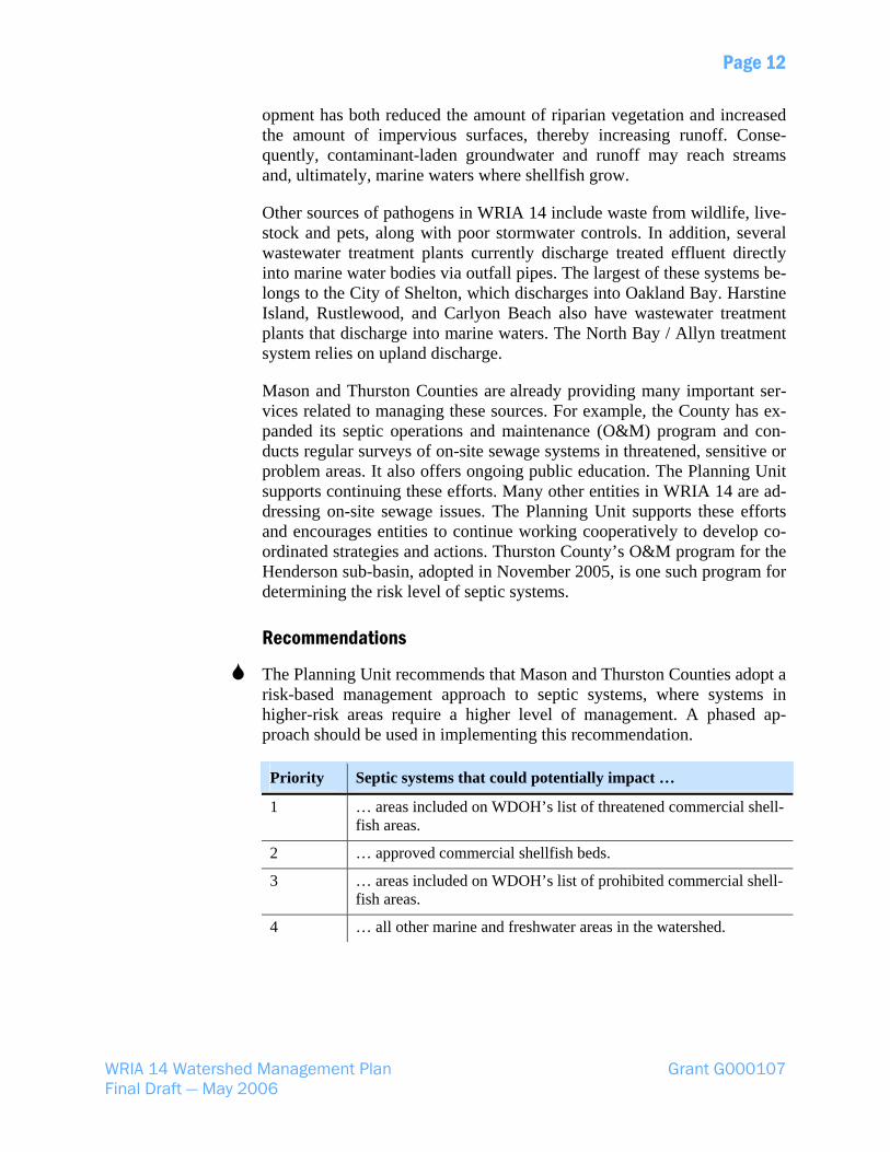
Mason and Thurston Counties are already providing many important ser-vices related to managing these sources. For example, the County has ex-panded its septic operations and maintenance (O&M) program and con-ducts regular surveys of on-site sewage systems in threatened, sensitive or problem areas. It also offers ongoing public education. The Planning Unit supports continuing these efforts. Many other entities in WRIA 14 are ad-dressing on-site sewage issues. The Planning Unit supports these efforts and encourages entities to continue working cooperatively to develop co-ordinated strategies and actions. Thurston County’s O&M program for the Henderson sub-basin, adopted in November 2005, is one such program for determining the risk level of septic systems.
Recommendations
The Planning Unit recommends that Mason and Thurston Counties adopt a risk-based management approach to septic systems, where systems in higher-risk areas require a higher level of management. A phased ap-proach should be used in implementing this recommendation.
Priority Septic systems that could potentially impact …
1 … areas included on WDOH’s list of threatened commercial shell-fish areas.
2 … approved commercial shellfish beds.
3 … areas included on WDOH’s list of prohibited commercial shell-fish areas.
4 … all other marine and freshwater areas in the watershed.
WRIA 14 Watershed Management Plan Grant G000107 Final Draft — May 2006

Page 13
The Planning Unit recommends that…
… WDOH review existing guidelines and regulations. WDOH should recommend updates to the Washington State Board of Health if needed to address nutrient issues or to incorporate new findings of relevant studies.
… Mason and Thurston Counties track all septic system waivers and variances and publish this list in an easily accessible format on their websites.
… all new treatment plants use upland discharge and that existing treatment plants develop a strategy to shift marine discharge to upland discharge, where feasible.
… Ecology encourage or require denitrification of sewage discharged via marine sewage outfalls.
Stormwater Management The Planning Unit finds that stormwater is a significant source of water quality problems and habitat degradation10.
Key Issues Stormwater carries a range of contaminants—oil, petroleum compounds from roads, and other and fine sediment into fresh and marine water bod-ies. In the more urbanized parts of WRIA 14, major storm events some-times tax the capacity of stormwater drainage systems, causing storm sew-ers and manholes to overflow. The resulting runoff flows into streams and eventually marine water bodies. Runoff also originates from rural parts of the watershed and carries contaminants into downgradient water bodies via streams and subsurface flow. An excess of fine sediment has been identified as a habitat limiting factor for several WRIA 14 streams, includ-ing Johns Creek11. Although this sediment originates mostly from eroding streambanks, other contributors include runoff from logging roads, high-ways, and development.
Recommendations In many cases, the most effective and economical method to manage stormwater is to allow natural infiltration and recharge by maintaining adequate pervious surfaces and vegetative cover12. In areas where this is
10 Satak, 1998 11 Kuttel, 2002 12 Booth, 2000
WRIA 14 Watershed Management Plan Grant G000107 Final Draft — May 2006

Page 14
not feasible, stormwater runoff should be carefully managed to minimize its impacts to water quality and habitat. not feasible, stormwater runoff should be carefully managed to minimize its impacts to water quality and habitat.
The Planning Unit recommends that Mason and Thurston Counties and the City of Shelton develop a comprehensive stormwater program by adopting the current Western Washington Stormwater Manual or its equivalent. The Stormwater Program should include:
The Planning Unit recommends that Mason and Thurston Counties and the City of Shelton develop a comprehensive stormwater program by adopting the current Western Washington Stormwater Manual or its equivalent. The Stormwater Program should include:
Stormwater controls for all new development and redevelopment Stormwater controls for all new development and redevelopment Stormwater site plan reviews Stormwater site plan reviews Stormwater control at construction sites Stormwater control at construction sites Proper operation and maintenance at stormwater facilities Proper operation and maintenance at stormwater facilities Pollution source controls Pollution source controls Illicit discharges and water quality response Illicit discharges and water quality response Problem identification and ranking Problem identification and ranking Low impact development (LID) Low impact development (LID) Public education and outreach on stormwater Public education and outreach on stormwater
The Planning Unit also recommends that Mason and Thurston Counties and the City of Shelton…
The Planning Unit also recommends that Mason and Thurston Counties and the City of Shelton…
… consider stormwater impacts and infrastructure improvements (par-ticularly retrofitting aging stormwater systems) a very high priority when they are prioritizing projects for limited capital funds.
… consider stormwater impacts and infrastructure improvements (par-ticularly retrofitting aging stormwater systems) a very high priority when they are prioritizing projects for limited capital funds.
… encourage private landowners to limit the amount of effective im-pervious surface on their properties and maintain native cover.
… encourage private landowners to limit the amount of effective im-pervious surface on their properties and maintain native cover.
… consider developing ordinances to set minimum standards for limit-ing effective impervious surfaces.
… consider developing ordinances to set minimum standards for limit-ing effective impervious surfaces.
Conservation Conservation The Planning Unit finds that there are multiple benefits when all users in WRIA 14 conserve water. Many streams in the basin are not meeting in-stream flows and are thus closed to further withdrawals. Conservation may be the optimal method to provide water for growth in the watershed with-out impacting stream flows.
The Planning Unit finds that there are multiple benefits when all users in WRIA 14 conserve water. Many streams in the basin are not meeting in-stream flows and are thus closed to further withdrawals. Conservation may be the optimal method to provide water for growth in the watershed with-out impacting stream flows.
Key Issues Key Issues A number of factors affect the adequacy of future water supplies in WRIA 14—the aquifer system, climate trends, withdrawals from regulated and unregulated wells, and limited conveyance infrastructure, among others. Despite these limitations, the population of WRIA 14 is projected to grow by 30 percent over the next 10 years. As a result, water demands will also
A number of factors affect the adequacy of future water supplies in WRIA 14—the aquifer system, climate trends, withdrawals from regulated and unregulated wells, and limited conveyance infrastructure, among others. Despite these limitations, the population of WRIA 14 is projected to grow by 30 percent over the next 10 years. As a result, water demands will also
WRIA 14 Watershed Management Plan Grant G000107 Final Draft — May 2006 WRIA 14 Watershed Management Plan Grant G000107 Final Draft — May 2006

Page 15
grow—by about 1,560 AF/yr, based on a daily consumption rate of 120 gallons per person and a population increase of 11,600. Conservation should be the first strategy considered to provide water for growth.
Recommendations
The Planning Unit recommends that Mason County, Thurston County, and the City of Shelton coordinate closely with the Planning Unit to develop and implement comprehensive water conservation plans for all water us-ers. These plans should be consistent with WAC 246-290-100 and WAC 246-291-140. They should also attempt to maximize conservation in the watershed in order to minimize the need for new water withdrawals. In preparing the plans, Counties should consider all conservation options and not be limited by minimum state standards. The conservation plans should include:
Incentives to retrofit existing homes with water-saving devices
Incentives or requirements for developers to leave natural vegetation in place in new developments
Standards for infrastructure in new developments to allow for water reuse
Measures to identify and correct leakage
Requirements for new developments to implement conservation meas-ures
Tiered-rate structures for water use to encourage conservation
Low impact development requirements
Financial incentives for water conservation
These plans should also specify conservation measures that should be im-plemented before a municipality can exercise inchoate rights in closed ba-sins.
The Planning Unit also recommends that Mason and Thurston Counties use water quantity and conservation information to develop or revise co-ordinated water system plans.
In addition, the Planning Unit recommends that Ecology or another state agency prepare a model conservation plan for consideration by watershed Planning Units. The plan should identify a wide range of potential strate-gies, summarize knowledge about how much water can be conserved, and estimate costs for implementation.
WRIA 14 Watershed Management Plan Grant G000107 Final Draft — May 2006

Page 16
Finally, the Planning Unit recommends that Ecology develop a definition of di minimus use of captured rainwater and request that the legislature al-low such uses without a permit.
Finally, the Planning Unit recommends that Ecology develop a definition of
Habitat Habitat The Planning Unit finds that many strong efforts are underway in WRIA 14 to restore and protect aquatic habitat. The Planning Unit finds that many strong efforts are underway in WRIA 14 to restore and protect aquatic habitat.
Key Issues Key Issues A number of factors affect the quality of habitat for salmonids, shellfish, and forage fish in WRIA 14. For optimum survival, salmonids require adequate streamflows, good-quality water, ample gravels that are rela-tively free of fine sediment, a functional riparian zone, and structures such as large woody debris, riffles, and pools. They also require cool stream temperatures. Some salmonids use WRIA 14’s nearshore areas for rearing, feeding, and migration. To transition successfully to the marine environ-ment, these fish require healthy, productive nearshore and estuarine habi-tats with high salt marshes, eelgrass, and shallow areas. In many areas, these factors have been compromised because of land use practices.
A number of factors affect the quality of habitat for salmonids, shellfish, and forage fish in WRIA 14. For optimum survival, salmonids require adequate streamflows, good-quality water, ample gravels that are rela-tively free of fine sediment, a functional riparian zone, and structures such as large woody debris, riffles, and pools. They also require cool stream temperatures. Some salmonids use WRIA 14’s nearshore areas for rearing, feeding, and migration. To transition successfully to the marine environ-ment, these fish require healthy, productive nearshore and estuarine habi-tats with high salt marshes, eelgrass, and shallow areas. In many areas, these factors have been compromised because of land use practices.
The marine waters of WRIA 14 have historically supported shellfish pro-duction. However, water quality in many marine areas has suffered due to high levels of fecal coliform bacteria. Parts of Shelton Harbor, Oakland Bay, and Hammersley Inlet are included on the most recent 303(d) list, which was finalized in 2005, because of fecal coliform. Other areas (Case Inlet and Squaxin, Peale, Pickering Passages) are listed for low dissolved oxygen. Furthermore, WDOH has prohibited, conditionally approved, or restricted shellfish harvesting in much of Oakland Bay and Hammersley Inlets.
The marine waters of WRIA 14 have historically supported shellfish pro-duction. However, water quality in many marine areas has suffered due to high levels of fecal coliform bacteria. Parts of Shelton Harbor, Oakland Bay, and Hammersley Inlet are included on the most recent 303(d) list, which was finalized in 2005, because of fecal coliform. Other areas (Case Inlet and Squaxin, Peale, Pickering Passages) are listed for low dissolved oxygen. Furthermore, WDOH has prohibited, conditionally approved, or restricted shellfish harvesting in much of Oakland Bay and Hammersley Inlets.
Recommendations Recommendations The Planning Unit supports ongoing habitat restoration, preservation and recovery activities funded through the Salmon Recovery Funding BoardThe Planning Unit supports ongoing habitat restoration, preservation and recovery activities funded through the
WRIA 14 Watershed Management Plan Grant G000107 Final Draft — May 2006
di minimus use of captured rainwater and request that the legislature al-low such uses without a permit.
Salmon Recovery Funding Board, the National Fish &Wildlife Foundation’s Community Salmon Fund, and other sources. These activities include:
The Lead Entity process The South Sound Salmon Sustainability Initiative The Shared Strategy for Puget Sound The Puget Sound Conservation and Recovery Plan The Puget Sound Nearshore Ecosystem Restoration Project (PSNERP) Co-manager initiatives (WDFW and Tribes)
WRIA 14 Watershed Management Plan Grant G000107 Final Draft — May 2006
Page 17
Furthermore, the Planning Unit suggests that all entities working on wa-tershed issues use technical resources to guide restoration / preservation activities in WRIA 14. Examples of such resources include technical documents, models, and guidelines:
Furthermore, the Planning Unit suggests that all entities working on wa-tershed issues use technical resources to guide restoration / preservation activities in WRIA 14. Examples of such resources include technical documents, models, and guidelines:
WRIA 14 Watershed Management Plan Grant G000107 Final Draft — May 2006
Type Resources
Documents Salmonid Habitat Limiting Factors, Water Resource Inventory Area 14 Salmon Habitat Protection and Restoration Plan for Water Resource Inventory Area 14, Kennedy-Goldsborough Chinook & Bull Trout Recovery Approach for the South Puget Sound Nearshore Reports on the nearshore studies
Models SHIRAZ (a habitat model) Ecosystem Diagnostic and Treatment (“EDT,” an analytical eco-system model) River history models
Guidelines WDFW’s aquatic habitat guidelines Integrated streambank protection guidelines Federal stream corridor restoration guidelines Design of Road Culverts for Fish Passage Stream habitat restoration guidelines Integrated streambank protection guidelines
Public Education & Outreach The Planning Unit finds that education and outreach is an essential first step in changing our approach to water use and management. Education helps us understand the importance of the issues, the voluntary actions we can take, and the need to enforce water laws to protect our resources.
Key Issues Many of the recommendations listed in this plan will require residents of WRIA 14 to change their behavior or their thinking. The success of these recommendations, therefore, will depend largely on education efforts. There is also a need for broad public education because, in many cases, residents and landowners are unaware of problems with water quantity and, to some degree, water quality.
WRIA 14 Watershed Management Plan Grant G000107 Final Draft — May 2006

Page 18
Recommendations
The Planning Unit recommends that outreach programs should be pro-vided by the local agency or organization best suited to address a particu-lar topic and reach key audiences effectively. Those implementing pro-grams can use a number of methods, including:
Volunteer programs (such as Stream Teams or Water Watchers) Mass media Mailings Presentations to specific organizations One-on-one assistance Workshops Outreach at public events
Programs should be designed to:
Reach key audiences Ensure that they understand the importance of the issue Provide technical resources to support actions and behavior changes Evaluate effectiveness
The Planning Unit recommends that effective education and outreach be consistently provided on the following topics:
Type Topic
Source control Septic system operation, maintenance and failure recognition Best management practices for farms (large, small, hobby) Best management practices for pet waste
Landscape management
Landscape management methods that protect water quality and minimize water use The retention and use of native vegetation in the landscape Stewardship practices for riparian areas, wetlands, and lake and marine shorelines Regulations governing development in the vicinity of streams, wetlands, and shorelines (presented as a clear sum-mary for landowners or prospective purchasers) Land management for salmon recovery
Stormwater management
Stormwater management methods that reduce runoff quan-tity, as well as minimizes contamination of water bodies Low impact development
General Water conservation methods Protection of groundwater from contamination
WRIA 14 Watershed Management Plan Grant G000107 Final Draft — May 2006

Page 19
The Planning Unit recommends that the entities listed below should ac-tively pursue funding. They should also work cooperatively to ensure that audiences receive consistent information and that public education pro-grams minimize overlap between entities and maximize efficiency.
The Planning Unit recommends that the entities listed below should ac-tively pursue funding. They should also work cooperatively to ensure that audiences receive consistent information and that public education pro-grams minimize overlap between entities and maximize efficiency.
Mason and Thurston Counties Mason and Thurston Counties Mason and Thurston Conservation Districts Mason and Thurston Conservation Districts City of Shelton City of Shelton Squaxin Island Tribe Squaxin Island Tribe WSU Extension WSU Extension Washington Sea Grant Washington Sea Grant South Puget Sound Salmon Enhancement Group South Puget Sound Salmon Enhancement Group Water purveyors Water purveyors
Compliance & Enforcement Compliance & Enforcement The Planning Unit finds that there are many potentially effective laws and regulations in place that govern the management of water. The Planning Unit finds that there are many potentially effective laws and regulations in place that govern the management of water.
Key Issues Key Issues If people complied fully with existing laws and regulations, many of the problems identified in the watershed plan would be minimized. The Plan-ning Unit believes that increasing compliance through both incentives and enforcement should be a high priority of state and local governments.
If people complied fully with existing laws and regulations, many of the problems identified in the watershed plan would be minimized. The Plan-ning Unit believes that increasing compliance through both incentives and enforcement should be a high priority of state and local governments.
Recommendation Recommendation
The Planning Unit recommends that the State, Mason and Thurston Coun-ties, and the City of Shelton give high priority to funding increased com-pliance and enforcement activities.
The Planning Unit recommends that the State, Mason and Thurston Coun-ties, and the City of Shelton give high priority to funding increased com-pliance and enforcement activities.
WFinWFin
Future Planning Future Planning The Planning Unit finds that the current WRIA 14 boundaries are not op-timal for addressing watershed issues in Hood Canal and Eld Inlet. The Planning Unit also finds that water availability should be considered as part of land use planning activities.
The Planning Unit finds that the current WRIA 14 boundaries are not op-timal for addressing watershed issues in Hood Canal and Eld Inlet. The Planning Unit also finds that water availability should be considered as part of land use planning activities.
Key Issues Key Issues South Shore Sub-Basin. Lands within WRIA 14 drain into one of two marine discrete water bodies: south Puget Sound or Hood Canal. Like much of south Puget Sound, the water in Hood Canal has been degraded.
South Shore Sub-Basin. Lands within WRIA 14 drain into one of two marine discrete water bodies: south Puget Sound or Hood Canal. Like much of south Puget Sound, the water in Hood Canal has been degraded.
RIA 14 Watershed Management Plan Grant G000107 al Draft — May 2006
RIA 14 Watershed Management Plan Grant G000107 al Draft — May 2006

Page 20
A variety of measures and studies have been undertaken to address these issues. Water quality cleanup efforts in Hood Canal hinge largely on con-trolling the pollution sources that originate from land use practices. The efficiency of these efforts could be improved if all the areas that drain into Hood Canal were consolidated. This would mean administering the South Shore Sub-Basin, which borders Hood Canal but lies within WRIA 14, as part of WRIA 16. WRIAs 14 and 16 have already agreed to include this sub-basin in WRIA 16 under the watershed planning process.
Eld Inlet. Like Hood Canal, Eld Inlet is currently split between two WRIAs—13 and 14. This water body could be managed more efficiently if it were within a single WRIA.
Planning & Future Water Availability. Future availability is not always considered in land use planning. Although the Growth Management Act (GMA) guides planning efforts in Washington State, it does not require governments to consider water availability at a parcel level when deter-mining land use designations. It is important that land use planners con-sider the information and recommendations provided in watershed plans such as this one. It is also important that planning efforts consider future water demands projected under GMA guidelines for each sub-basin. These demands should be addressed at both the watershed scale and at the local scale, by water purveyors.
Recommendations
The Planning Unit recommends that Mason and Thurston Counties and the City of Shelton estimate the anticipated demand for water and then recon-cile discrepancies between water demand and availability, using a process consistent with GMA. The water-demand estimates should be based on land use designations, as well as on population projections and allocations in the comprehensive plans.
The Planning Unit recommends that the Legislature separate WRIA 14 into two WRIAs—14A and 14B. The South Shore of Hood Canal (which is included in the WRIA 16 planning process under an agreement between WRIAs 14 and 16) should be designated “WRIA 14B.” The Planning Unit also recommends that WRIA 14B be administered as part of WRIA 16.
The Planning Unit recommends that, in the future, the State consider con-solidating all areas that drain into Eld Inlet into the same WRIA.
elton coordinate planning under the GMA with water resource
planning.
The Planning Unit recommends that Mason and Thurston Counties and the City of Sh
WRIA 14 Watershed Management Plan Grant G000107 Final Draft — May 2006
Page 21
References Ahmed, A. 2004. Quality Assurance Project Plan Tributaries to Totten, Eld, and
Little Skookum Inlets Temperature and Fecal Coliform Bacteria Total Maximum Daily Load Study. Olympia, WA: Washington State Department of Ecology Publication No. 04-03-106, dated May 2004.
Ahmed, A., and Sullivan, L. 2004a. Draft Quality Assurance Project Plan Total Maximum Daily Load Analysis for Temperature in Tributaries to Oakland Bay-Hammersley Inlet: Mill Creek, Cranberry Creek and Johns Creek. Olympia, WA: Washington State Department of Ecology Publication No.__ dated July 26, 2004.
_____________________. 2004b. Draft Quality Assurance Project Plan Fecal Coliform Bacteria TMDL for Oakland Bay-Hammersley Inlet and Tribu-taries. Olympia, WA: Washington State Department of Ecology Publica-tion No. 03-03-1__ dated July 21, 2004.
Bauman, B., and Schafer, W. 1985. “Estimating Ground-Water Quality Impacts from On-Site Sewage Treatment Systems.” On-Site Wastewater Treat-ment: Proceedings of the Fourth National Symposium on Individual and Small Community Sewage Systems. American Society of Agricultural En-gineers, St. Joseph, Michigan.
Booth, D. 2000. Forest Cover, Impervious Surface Area, and the Mitigation of Urbanization Impacts in King County, Washington. Prepared for the King County Water and Land Resources Division. Seattle, WA.
Canter, L., and Knox, R. 1985. Septic Tank System Effects on Ground Water Quality. Lewis Publishers, Inc. ASTM.
Envirovision Corporation. 2003. WRIA 14 Surface Water Quality Monitoring Strategy.
Golder Associates. 2003. Kennedy-Goldsborough Watershed (WRIA 14) Phase II-Level 1 Assessment. Consultant's report prepared for the WRIA 14 Plan-ning Unit, dated March 2003.
Kenny, S. 2004. Task 5—Implementation of Tier I of the WRIA 14 Water Quality Monitoring Plan, Quarterly and Final Report of Grant activities, October 27, 2003–December 31, 2004. Prepared for the Washington State Depart-ment of Ecology by Mason County Heath Services, under the WRIA 14 Water Quality Grant – GO300147.
WRIA 14 Watershed Management Plan Grant G000107 Final Draft — May 2006

Page 22
Kimsey, M. 1992. Ground Water and On-Site Sewage Disposal Systems: Estab-lishing Density Criteria to Protect Ground Water Quality. Washington State Department of Ecology, Water Quality Program.
Kuttel, M. 2002. Salmonid Habitat Limiting Factors Water Resource Inventory Area 14, Kennedy-Goldsborough Basin, Final Report—November 2002. Olympia, WA: Washington State Conservation Commission.
Satak, W. 1998. “Real-World Sanitary Survey Results and Correction of On-Site Problems in Two Important Shellfish Growing Areas in Mason County, Washington” in Proceedings of the 1998 Puget Sound Research Confer-ence from Puget Sound Seafood—The Human Health Link.
WRIA 14 Watershed Management Plan Grant G000107 Final Draft — May 2006