Embed Size (px)
Citation preview

1
Wrexham County Borough Rights of Way Improvement Plan 2019
Appendix 2

2
Foreword
Wrexham County Borough Council is committed to working towards improving its rights of way network. We have taken a strategic look at what we have and how it could be improved for people living, working and visiting Wrexham. The Rights of Way Improvement Plan (ROWIP) process, as required by the Welsh Government, sets out how we will do this.
There have been major improvements to Wrexham’s public rights of way network over the last ten years, funded by Wrexham County Borough Council and grants from the Welsh Government.
The new Rights of Way Improvement Plan needs to be viewed in the context of the continued reduction in Wrexham County Borough Council Budget, which has led to less resources available for Council services. The Council budget reductions coupled with the ceasing of the Welsh Government Rights of Way Improvement Plan grant means, the Plan is of necessity focused in its approach on the highest priorities.
I hope you will take time to read the plan, it is a result of an extensive consultation from December 2016 to October 2018. We have consulted many different groups and people and we hope we have captured their priorities and put them in the Statement of Action.
We can continue to improve our rights of way and we believe this plan sets out how we will do this.
3
ContentsPage No Content
6 Executive Summary
8 Vision
8 Introduction
9 Background to this Work
9 Public Rights of Way Network
9 Other Publicly Accessible Greenspace and Countryside
10 The Management of the Public Rights of Way
10 Access Forum
11 What is a ROWIP?
11 What’s in a ROWIP?
12 The Need for a Rights of Way Improvement Plan
12 How will Wrexham County Borough Council be held accountable for the Rights of Way Improvement Plan?
12 How will Wrexham County Borough Council ensure the Targets are Achieved in the Rights of Way Improvement Plan?
12 Partnership Working
13 Policy Context

4
13 The Well-Being of Future Generations (Wales) Act 2015
14 Environment (Wales) Act (2016)
14 Natural Resources Policy (2017)
15 Wrexham County Borough Council Plan 2017-22
16 Wrexham’s Well-Being Plan, Wrexham Public Service Board
18 Active Travel Plan
19 Wrexham Local Development Plan 2 (LDP2) 2013-2028
20 Strategic Environmental Assessment and Equality Impact Assessment
21 Assessment Phase
21 Introduction
21 Evaluating the Delivery of Previous ROWIP
31 Evaluating the Current Condition of the Network and its Legal Record
31 2017 Condition Survey of the ROW Network – Bridges
32 Evaluating the Record of Limitations and Authorised Structures on the Public Rights of Way Network
33 Consultation Process
33 Public Rights of Way Consultation Survey Results - Initial Consultation - 1 December 2016 – 30 January 2017
33 Community Councils Views on Public Rights of Way

5
34 Other Views from Initial Consultation
36 On-line Public Targeted Consultation
37 Consultation on Draft Rights of Way Improvement Plan 2018
38 Wales Outdoor Recreation Survey 2014
39 Assessing Public Need and Identifying Opportunities
39 Breakdown of Electoral Wards into Population, Area and Length of Public Rights of Way
41 Strategic Aims of the Rights of Way Improvement Plan
43 Wrexham Rights of Way Improvement Plan Statement of Action
52 Rights of Way Improvement Delivery Plan
52 Funding
53 Monitoring and Evaluation
53 References
6
1 Executive Summary
Wrexham’s first Rights of Way Improvement Plan 2007 has seen the steady investment over 10 years yield improvements in the accessibility of the rights of way network. Approximately three quarters of the network are easy to use and accessible now. Between 2008/9 and 2016/17 , a total of 1726 lengths of paths received work, 177 bridges and bridge crossings were repaired, 713 new kissing gates and 528 stiles installed/repaired and 1053 finger posts erected to indicate the right of way. The funding from the Rights of Way Improvement Grant from Welsh Government has allowed extensive use of kissing gates to replace stiles. This has been an important aspect of the Wrexham ROWIP over the last 10 years. The new gates have made many footpaths much more accessible for people with some mobility impairments.
The target of a copy of the Definitive Map to be available to view on line was completed. This has been well utilised by members of the public and changed the way people access the service.
To maintain this improvement for the next ten years of the plan requires further steady investment, particularly in making the path system more accessible for people with reduced mobility. As local authority budgets and staff continue to reduce, the challenge will be to identify external funding and encourage more self help from the community to develop and improve the rights of way. The best way of maintaining public rights of way is to encourage more use of the paths, this keeps vegetation down and helps in finding out where there are footpath problems.
This needs to be part of a broader Welsh Government drive to get people more active. The plan seeks to work more closely with Community Councils and to encourage a much greater involvement in improving rights of way by local people. The Joint Local Access Forum has an important part to play through encouraging different sections of the community to work together, such as landowners and the users, to improve the network, also to advise Wrexham County Borough Council on how it considers improvements are needed in countryside access.
The consultation process revealed that regular users of the public rights of way system are interested in accessible paths which are well maintained and waymarked. They are less keen on information on where to walk or accessing walking groups. There is good support for continuing to make paths more accessible through the use of gates rather than stiles.
7
Those most likely to be interested in visiting the outdoors more often included 16 to 54 year olds (67%), people with children in the household (68%) and those in paid employment (66%). Those who had taken a visit in the last 4 weeks were more likely than those who had not, to indicate that they would like to visit more often (61% and 56%). A lower than average proportion of people aged 55 and over (48%) and those not in paid employment (54%) expressed an interesting visiting the outdoors more often.
The priority in the new Rights of Way improvement Plan must be to continue to improve the existing rights of way system before major additions are made to the network. This doesn’t preclude the development of key links to help improve connectivity of the rights of way network.
The core of the Rights of Way Improvement Plan is a Statement of Action, which sets out the work the Authority with its partners, proposes to undertake, to maintain the network of rights of way and access opportunities in the County Borough. The proposed policies are presented under 8 aims.
The document is strategic and long term. Each aim is supported by a section on the issues and a statement of intent. Due to the long term nature of the plan, there are no indication of costs, timescale or funding. The Rights of Way Improvement Delivery Plan will set out in detail what the local Authority will deliver with timescales, targets and budget. This document is likely to be an annual plan.
Improvements in the network, developmental and promotional work must come from external funding, sourced and delivered mainly by external groups and organisations.
Core funding for the statutory duties of maintenance of the rights of way network and managing the definitive map will continue to be supported by Wrexham County Borough Council.

8
2 Vision
A vision for Wrexham’s Rights of Way Network
2.1 The long term vision for Wrexham’s rights of way network, is a network of paths, easy to use and useful, connecting the countryside with the towns and villages. The network is well used by people of all ages and abilities, walking or riding for leisure or for work. People are able to easily download a variety of information from the Council website, whether it’s for a walk, cycle ride or horse-riding route in their area or for specific information about their rights and responsibilities. The Definitive Map is up-to-date and published on the web. Any problems with obstructions are reported back through a network of volunteers, in each community or direct to the Council. The paths are well maintained, signed and the pride of each community.
3 Introduction
3.1 Providing access to greenspace, parks or the countryside through the rights of way network, for the majority of the local population, is an important part of the work of Wrexham County Borough Council. It brings health benefits and is a relatively low cost way of gaining fresh air and exercise and improving mental well-being. Whether this is walking in a group, alone or with a dog, running, cycling or horse-riding, encouraging more people to take exercise is a key goal of the Welsh Government. Fitter, healthier people reduce the strain on the National Health Service, which helps the economy.
3.2 The first Rights of Way Improvement Plan has seen huge improvements in the accessibility of the public rights of way across Wrexham. The percentage of public rights of way which are easy to use has risen from 35% across the network in 2005/6 to 77% in 2016/17.
3.3 This improvement has been largely due to sustained investment in the network, through the Countryside Council for Wales followed by Natural Resources Wales (Welsh Government grant aid), European funding, through the Rural Development Plan and capital money from Wrexham County Borough Council. This has produced investment and grant aid of £544,610 over the plan period.
3.4 To maintain this improvement for the next ten years of the plan requires further steady investment, particularly in making the path system more accessible for people with reduced mobility. As Local Authority budgets and staff continue to reduce, the

9
challenge will be to identify external funding and encourage more self-help from the community to develop and improve the rights of way.
3.5 However, the best way of maintaining public rights of way is to encourage more use of the paths, this keeps vegetation down and helps in finding out where there are footpath problems. This needs to be part of a broader Welsh Government drive to get people more active.
4 Background to this Work
4.1 The Wrexham Rights of Way Improvement Plan was produced in 2007, following the assessment phase work which was completed between 2005 and 2006. The work was part funded by Welsh Government and the document was ambitious in what it set out to achieve. The new Rights of Way Improvement Plan needs to be set in the context of significantly less staff resources and budget in Wrexham County Borough Council. There are less than half the staff working in rights of way in 2018, compared to 2007, their role is to deliver the statutory requirements in terms of rights of way and highway law. The actions above and beyond this work need to be delivered by volunteers, Community Councils and other interested parties, using different ways of working.
5 Public Rights of Way Network
5.1 The public rights of way network in Wrexham County Borough consists of 783 kms of footpaths, 60 kms of bridleway and 7 kms of byways open to all traffic. This gives a figure of 850 kms of rights of way in Wrexham County Borough. The length of national trails/long distance routes/other promoted routes in Wrexham County Borough is 367 kms.
6 Other Publicly Accessible Green Space and Countryside
6.1 Wrexham is very fortunate to have a good Country Park and urban park network of 11 parks, serving the majority of the population of Wrexham. There are large areas of access land on Ruabon Mountain and the Berwyn’s . Nant y Ffrith valley has an access agreement for walkers to use the valley. The National Trust and Woodland Trust also own publicly accessible land, such as Erddig, Chirk Castle, Nant Mill Woods, Plas Power Woods and Coed Collfryn. There are publicly accessible National Nature Reserves at Fenns Whixall Moss on the border of England and on the Berwyns along the Denbighshire County Council border to the west. The Natural Resources Wales woodland of Nantyr forms a link between the north Berwyn Way

10
and the Ceiriog Trail. There is also a network of unclassified roads, which are used for recreation, particularly in the Ceiriog Valley.
6.2 The Clwydian Range and Dee Valley AONB covers a section of Wrexham along the Dee Valley and Minera Mountain. Public rights of way cross these areas and public access is encouraged.
7 The Management of the Public Rights of Way
7.1 The network of public rights of way in Wrexham County Borough is managed by the Council’s Rights of Way team. The Rights of Way team is part of the Environment Department of Wrexham County Borough Council.
7.2 The small Rights of Way team integrate the management of the definitive map and maintenance and enforcement work into their daily work. They deal with all rights of way issues and liaising with members of the public, contractors and landowners. Advice and support is gained from the County Borough Council’s Legal officers, as required.
8 Access Forum
8.1 The Wrexham Local Access Forum merged with the Flintshire Access Forum in 2019, to form a joint strategic forum covering Wrexham County Borough Council and Flintshire County Council. Flintshire County Council and Wrexham County Borough Council provide a joint secretariat for the Forum.
8.2 This joint forum takes a more strategic approach to rights of way and access issues across the two counties and can integrate with the management of the Area of Outstanding Natural Beauty, which covers sections of Denbighshire, Flintshire and Wrexham.
8.3 The Wrexham Access Forum worked with Wrexham County Borough Council on developing the new Rights of Way Improvement Plan across 2017. The joint Local Access Forum will continue to provide advice and assistance to the two counties in terms of the rights of way improvement plans.

11
9 What is a ROWIP?
9.1 The Rights of Way Improvement Plan (ROWIP) is a strategic document which will help the Authority to manage the rights of way network for the residents of Wrexham County Borough and visitors to the area. This Plan lays out how Wrexham County Borough Council will deliver improvements to the rights of way network and how we will continue to improve the management of rights of way.
9.2 The plan is a strategic document and lays out a ten year programme for the Wrexham County Borough rights of way network. There is a statutory duty to publish the plan (Wrexham County Borough Council, as a Highway Authority, is required (under Section 60 of The Countryside and Rights of Way Act 2000) to develop and publish a Rights of Way Improvement Plan).
10 What’s in a ROWIP?
10.1 The legislative guidance (Section 60(3)(a) and 60(2) Countryside and Rights of Way Act 2000) makes it clear that the Rights of Way Improvement Plan (ROWIP) should assess:
“…the extent to which local rights of way meet the present and likely future needs of the public.” “…the opportunities provided by local rights of way (and in particular by footpaths, cycle tracks, bridleways and restricted
byways) for exercise and other forms of open air recreation, the enjoyment of their area and the accessibility of rights of way to blind or partially sighted persons and others with mobility problems.”
10.2 The Rights of Way Improvement Plan (ROWIP) should also include a statement of the actions that the Council propose to take for the management and improvement of the network of rights of way.
10.3 In addition, revised ROWIP assessments (Guidance for Local Authorities on Rights of Way Improvement Plans, July 2016, Welsh Government) should ensure that they address the following:
An evaluation of the degree to which the previous ROWIP has been delivered An evaluation of the present condition of the network and its record Opportunities to contribute to active travel objectives

12
Opportunities to contribute to well-being objectives Opportunities to contribute to the delivery of other plans and priorities
11 The Need for a Rights of Way Improvement Plan?
11.1 Wrexham County Borough Council, as the Highway Authority, has a statutory responsibility to write and publish a plan. It is also a sensible approach to the management of a service to possess a long term vision and plan for its development and improvement. The published plan should help everyone to see what our goals and policies are and how they can help us in achieving this. It will also help in applying for grant aid or other money to support the work that needs to be done.
12 How will Wrexham County Borough Council be held accountable for the Rights of Way Improvement Plan?
12.1 A report on the progress in meeting targets for the Rights of Way Improvement Plan will be regularly submitted to the joint Flintshire and Wrexham Local Access Forum and to members of Wrexham County Borough Council and Flintshire County Council. Wrexham County Borough Council Members have considered and commented upon the Rights of Way Improvement Plan, as it has developed and undergone the consultation process to create the final document.
13 How will Wrexham County Borough Council ensure the Targets are Achieved in the Rights of Way Improvement Plan?
13.1 It is intended that an Annual Action Plan will be produced to coincide with Wrexham County Borough Council budgeting system. This will outline annual projects and commitments for the network over the coming year and will ensure the targets laid out in the Rights of Way Improvement Plan are realistic and achievable within the current financial resources of that year and matched to any relevant grant aid applications.
14 Partnership Working
14.1 Partnership working is essential to deliver the Rights of Way Improvement Plan. Wrexham County Borough Council does not have the resources in terms of staff or budgets to undertake more than statutory work. It is important that to support the plan, voluntary organisations such as the Rambler’s Association and the North East Bridleways Association and Walkabout Wrexham take a much more proactive role in improving and maintaining the rights of way network.

13
14.2 The plan seeks to work more closely with Community Councils and to encourage a much greater involvement in improving rights of way by local people. The Joint Local Access Forum has an important part to play through encouraging different sections of the community to work together, such as landowners and the users, to improve the network, also to advise Wrexham County Borough Council on how it considers improvements are needed in countryside access. New partnerships are needed, possibly through link ups with business, getting them to volunteer and help improve areas.
15 Policy Context
15.1 The key area of new legislation is the Well-being of Future Generations (Wales) Act. This is underpinned by the Environment (Wales) Act and this is supported by the Natural Resources Policy. The Natural Resources Policy of the Welsh Government also supports the delivery of ‘Prosperity for All - the national strategy’. The Wrexham County Borough Council Plan and the subsidiary Rights of Way Improvement Plan sit within this environmental framework.
16 The Well-Being of Future Generations (Wales) Act (2015)
16.1 This seeks to improve the social, economic, environmental and cultural well-being of Wales by requiring public bodies to work together to create a sustainable Wales. It is intended to help create a Wales that we all want to live in, now and in the future. The Act places a “well-being duty” on public bodies, including Local Authorities in Wales. The well-being duty states:
Each public body must carry out sustainable development. The action a public body takes in carrying out sustainable development must include:a. setting and publishing objectives (“well-being objectives”) that are designed to maximise its contribution to achieving
each of the well-being goals, andb. taking all reasonable steps (in exercising its functions) to meet those objectives.
16.3 This means that each public body listed in the Act must work to improve the economic, social, environmental and cultural well-being of Wales. To do this they must set and publish well-being objectives.

14
17 Environment (Wales) Act (2016)
17.1 The Environment (Wales) Act requires public bodies to manage the natural resources of Wales in a sustainable way – securing healthy, resilient and productive ecosystems for the future, whilst still meeting the challenges of creating jobs, housing and infrastructure. It also requires authorities to maintain and enhance biodiversity when undertaking all their duties.
17.2 The Environment (Wales) Act 2016 sets out the requirement for the ‘sustainable management of natural resources’ together with new ways of working to achieve this. The Act requires us to set out the challenges our natural resources and ecosystems face and the opportunities they can provide. This means looking at the ways we currently manage our natural resources and how we can reduce the pressures on them. Through actions such as increasing resource efficiency or reducing pollution, the aim is to build greater resilience into our ecosystems. The Environment (Wales) Act 2016 supports and reinforces the WFG Act and should also drive the development of Local Authorities’ plans.
18 Natural Resources Policy 2017
18.1 The focus of the Natural Resources Policy (NRP) is on improving the way we manage our natural resources. This is a key part of the delivery framework for the sustainable management of natural resources established by the Environment (Wales) Act.
18.2 The Natural Resources Policy states “Areas with more accessible green space are associated with better mental and physical health and health inequalities can be significantly reduced in greener areas. Attractive and accessible green and blue spaces, such as country or community parks, provide a focus for community activities and identity and can be a stimulus to regeneration and investment.
18.3 Welsh Government states in the Policy under Local Environmental Quality and Community Well-Being:
“Plan the development of green infrastructure at the heart of our communities to deliver space for recreation, transport corridors for cycling and walking.”

15
18.4 Ensure our communities benefit from healthy environments, by identifying opportunities to take actions that improve respiratory conditions, inactivity and mental health. These include increasing green space and tree cover and improving public access to green infrastructure. We will support communities to improve places where they live and work, tackling local environmental issues such as litter and fly tipping which affects mental and physical health”.
18.5 Welsh Government states in the Policy under Transport:
“Improve the connectivity and diversity of our ecosystems through initiatives that promote green corridors, strategic tree planting and appropriate vegetation management and further improvements to the environmental quality of urban and rural transport networks. Integrate nature based solutions into the planning and development of new transport related infrastructure.”.
19 Wrexham County Borough Council Plan 2017-22
19.1 The Council Plan is the means by which Wrexham County Borough Council has published its Well-Being Statement and has defined its Well-Being Objectives as required by the Well-Being of Future Generations (Wales) Act 2015. It is also the means by which the Council sets its Improvement Objectives and meets the requirements of the Local Government (Wales) Measure 2009 for the Council to put an ‘Improvement Plan’ in place as soon as practicable after the start of the financial year.
19.2 The Council Plan sets out 4 key themes, these are: Economy People Place Organisation
The relevant sections of the Council Plan that integrate with the Rights of Way Improvement Plan are:
PE5 (People theme) – Enabling access to leisure and cultural activities

16
There are strong links between people’s access to green space, leisure and cultural activities and their overall well-being. The more people use these things, the greater the quality of life they can have. Our long term vision is to: have a County Borough where people can still access the countryside and a wide range of leisure, cultural and heritage activities and events according to their interests and budget. In the medium to long term, to achieve this we will: review and implement the Rights of Way Improvement Plan, assessing the current position and identifying improvements to the public rights of way network that will support a better experience for walkers, cyclists, equestrians and other users.
Pl4 (Place theme) – Well-connected and sustainable communitiesThe availability of jobs or the existence of green spaces, shopping and cultural opportunities, mean little if people cannot access them easily and affordably. We will seek to ensure that local people have a range of sustainable transport options by lobbying and working with partners to maintain and improve our transport infrastructure and by doing what we can to support local public transport providers.Our long term vision is to: have an accessible, efficient transport network which allows people a choice between transport options which are convenient and sustainable.In the medium to long term, to achieve this we will: Review and implement the Rights of Way Improvement Plan, assessing the current position and identifying improvements to the public rights of way network that will support a better experience for walkers, cyclists, equestrians and other users; and invest in and improve our transport systems including promoting more sustainable transport options as part of the Active Travel (Wales) Act 2013.
20 Wrexham’s Well-Being Plan, Wrexham Public Service Board20.1 Wrexham Public Service Board (PSB) is a statutory body established in April 2016 as a result of the enactment of the Well-
Being of Future Generations (Wales) Act 2015. The purpose of the PSB is to improve the economic, social, environmental and cultural well-being of Wrexham County Borough.
To do this they must: • Assess the state of the economic, social, environmental and cultural well-being in their area; and

17
• Set objectives that are designed to maximise the PSB’s contribution to the well-being goals.
20.2 A well-being assessment provides an analysis of social, economic, environmental and cultural well-being in a local area. The well-being assessment has been undertaken and provides an analysis of well-being in Wrexham County Borough as of March 2017.
20.3 The local well-being plan setting out the objectives and the steps the PSB proposes to take to meet them was published 2018. The PSB Plan covers the period 2018-2023. Each year there are key objectives the plan will focus on. The PSB has created a long list of 15 priority areas. The most relevant to the rights of way improvement plan are outlined below -
PSB Long List of Priorities
Priority 2 – children and young people are given a healthy start in life
Parents, children and young people are able to make healthy choices
Priority 5 People are able to make healthy choices
People eat and drink healthily and take part in physical activity.
Priority 8 There is a range of things for people to do in their spare time
All people can access a range of social, cultural, sporting and leisure activities. People make use of the countryside, parks and woodlands.
Priority 9 - The economy in rural areas is well supported and can thrive
The agricultural sector is adaptable, diverse and resilient.

18
Rural areas are better connected by good transport links.
Priority 11 People can travel easily around the county and beyond.
People can access a range of sustainable and community based transport options.
The PSB Plan also commits to developing in the medium term, the following.
Develop a green infrastructure plan for Wrexham to identify what we have and how best to connect and developour green spaces in order to promote an active lifestyle.
Lead a campaign to ‘share the space’ for public sector organisations in Wrexham to encourage the use of thegreen spaces they have for physical activity and play, promoting an active lifestyle in order to have a betternights sleep.
21 Active Travel Plan
21.1 The Active Travel (Wales) Act 2013 places new duties on Local Authorities in Wales to produce and publish active travel maps. The first stage of the Act required Local Authorities to produce an ‘Existing Routes Map’ and submit this to the Welsh Government for approval by January 2016. The Existing Routes Map relates to specific areas in Wales, which are determined by population as specified in the Active Travel (Wales) Act 2013.
21.2 The Existing Active Travel Routes Maps do not show all walking cycling routes in the County Borough. The map only includes those routes that meet the definition of an Active Travel Route as set down in the Active Travel (Wales) Act 2013. In summary:
Routes suitable for walking and cycling (including the use of mobility scooters).

19
Routes that fall within or link settlements specified designated localities within the County Borough of Wrexham. These are: Rossett, Llay, Sydallt, Gresford, Bradley, Tan-y-Fron, Wrexham, Coedpoeth, Rhostyllen, Rhosllanerchrugog, Ruabon, Trevor and Chirk.
Routes that fit with definition of an ‘Active Travel Journey’. Broadly this includes journeys made to or from a workplace or educational establishment in order to access health, leisure or other services of facilities.
Routes that are considered fit for purpose in line with the requirements of the Welsh Government’s ‘Design Guidance Active Travel Wales (Act) 2013’.
21.3 Following a public consultation in 2015 on Wrexham’s Draft Existing Route Maps (ERM), amendments were made as a result of the responses received and the revised ERM was submitted to Welsh Ministers in January 2016 for approval. There are 14 maps covering each of the designated settlements in Wrexham which make up Wrexham’s Existing Route Map.
21.4 The Integrated Network Map sets out Wrexham Council’s 15-year vision to improve cycling and walking routes across the County Borough, in order to meet the requirements of the Active Travel (Wales) Act 2013 to plan for the provision of routes and improvements for active travel.
22 Wrexham Local Development Plan 2 (LDP2) 2013 to 202822.1 Wrexham County Borough Council is preparing the Local Development Plan (LDP) which will replace the current
adopted Unitary Development Plan. The LDP will be a long-term land use and development strategy focused on achieving sustainable development and will: guide development for housing, employment, retail and other uses, set out policies that will be used to decide planning applications, and safeguard areas of land requiring protection or enhancement.
The Plan’s current projected adoption date is towards the end of 2019.
22.2 Strategic Policy SP20: Green Infrastructure in Wrexham’s Local Development Plan sets out the approach to caring for and protecting the green infrastructure of the County Borough. The policy aims to ensure that the County Borough’s new green
20
and blue infrastructure assets are strategically planned and delivered through a high quality and locally distinct infrastructure network and that existing green infrastructure assets are protected and enhanced. The rights of way improvement plan fits within the green infrastructure framework.
22.3 Wrexham’s distinctive natural heritage provides a network of green and blue infrastructure. Protection, conservation and enhancement of natural heritage networks needs to be reconciled with the benefits of development.
22.4 Development will be required to maintain the extent, quality and connectivity of multi-functional green infrastructure on or near a site and where appropriate to enhance it by :
Creating new interconnected areas of green infrastructure between the proposed site and the existing network, Filling gaps in the existing network to improve connectivity, Protecting the features most valuable for both nature and people, and In instances where loss of green infrastructure is unavoidable, provide mitigation and compensation for the lost assets
on a site specific basis.
22.5 Strategic Environmental Assessment and Equality Impact Assessment
The Wrexham Rights Of Way Improvement Plan has been screened using the information supplied in “A Practical Guide to the Strategic Environmental Assessment Directive- practical guidance on applying European Directive 2001/42/EC”on the assessment of the effects of certain plans and programmes on the environment”. The screening by the Parks, Countryside and Rights of Way Lead, indicated that a Strategic Environmental Assessment did not need to be carried out on the Wrexham Rights Of Way Improvement Plan, as the plan did not fall within the scope of the Strategic Environmental Assessment. An Equality Impact Assessment screening was also undertaken for the plan.

21
23 Assessment Phase
Introduction
23.1 The assessment phase of the new rights of way improvement plan was carried out between December 2016 and December 2017. This reviewed the work of the previous rights of way improvement plan and considered its successes and failures. It undertook targeted consultation work with interest groups and people with sight impairments, as indicated in the national guidance (Guidance for Local Authorities on Rights of Way Improvement Plans, July 2016, Welsh Government). A review of the condition of the rights of way network was undertaken and a bridges survey was completed. The current position in terms of the definitive map has been set out, including the number of definitive map modification orders that are outstanding.
24 Evaluating the Delivery of Previous ROWIP
24.1 A review of the Wrexham Rights of Way Improvement Plan 2007 (ROWIP) was undertaken as part of the preparation for the development of the new Wrexham ROWIP. The performance of each action since 2007 was considered under a comments column and a summary of the performance of each section was undertaken below the main aim and issues of the 2007 ROWIP Action Plan. This work was shared with the Wrexham Local Access Forum, during 2017 and their comments incorporated into the document. The complete review of the actions in the 2007 ROWIP plan can be seen in Appendix 2.
Outlined below are the key actions in the 2007 ROWIP and the performance in achieving the objectives.
9.0 Aim - Looking after our rights of way - A well maintained, signposted network, free from obstruction
Performance since 2007
Access to the rights of way network
During the period of the ROWIP, an annual survey on the condition of the rights of way network has been collected. The performance indicator measures paths or links that are easy to use, using set criteria. The data is collected each year through a 5% sample of the network, following national guidelines for data collection. The baseline figure of 35% of the network open and easy to use in 2006/7 was recorded at the start of the ROWIP.

22
There has been sustained investment in the network, through the Countryside Council for Wales followed by Natural Resources Wales (Welsh Government grant aid) , European funding, through the Rural Development Plan and capital money from Wrexham County Borough Council. This has produced grant aid investment of £544,610 over the plan period and has resulted in three quarters of the rights of way network opened up for use by 2017. The ROWIP 2012 target figure of 70% of the network open and easy to use, was achieved by 2013. This represents one of the major achievements of the Wrexham ROWIP.
There has been year on year investment during the period of the ROWIP, in small and large bridge structures, surfacing, waymarking and the use of pedestrian/kissing gates to replace stiles. This has resulted in a much more accessible public rights of way network.
The statistics below indicate between 2008/9 and 2016/17, a total of 1,726 lengths of paths received work, 177 bridges and bridge crossings were repaired, 713 new kissing gates and 528 stiles installed/repaired and 1,053 fingerposts erected to indicate the right of way. The resurfacing and repair of the rights of way paths made the network easier to use, 101 paths were resurfaced between 2008/9 and 2016/17.
Year Percentage of total length ofrights of way which are easy to use
2006/7 35%2007/8 33%2008/9 40%
2009/10 42%2010/11 51%2011/12 61%2012/13 68%2013/14 75%2014/15 76%2015/16 70%2016/17 77%2017/18 51%

23
2018/19 70%
10.0 Aim - Updating the Definitive Map
Performance since 2007
24 DMMO’s (Definitive Map Modification Orders) completed since 2007. 7 DMMO decisions with no order.
Improvement work carried out on therights of way network during the ROWIP
2008/9 2009/10 2010/11 2011/12 2012/13 2013/14 2014/15 2015/16 2016/17 Total
Paths receiving work
150 120 113 275 234 180 211 184 100 1,726
Bridges/ditch crossings replaced
5 large bridges plus boardwalk
5 large bridges
4 large bridges
22 27 28 36 23 10 including 1 x 10 metre footbridge installed
177
Kissing gates installed
3 27 80 94 95 97 94 88 52 713
Paths resurfaced/ repaired
3 6 3 27 28 11 19 4 0 103
Stiles replaced/ repaired
33 37 45 85 82 69 69 58 13 528
Fingerposts replaced
93 111 126 345 132 65 78 53 17 1,053
24
21 DMMO applications received since 2007. 7 public inquiries held. 38 Public Path Orders (diversions and extinguishments) have been completed. Backlog of DMMO’s at the start of December 2018 is 22. At the start of December 2018, PPO (Public Path Orders) backlog is 8, excluding redundant applications. ROWIP backlog of DMMO’s in 2007 was 32. When the backlog was reviewed, this figure was found to include 5
applications which were historical and were not valid applications. A copy of the Definitive Map is available to view on-line. The publication of an updated and consolidated Definitive
Map has not been achieved.
At the end of the current ROWIP, many of the old DMMO cases stretching back many years have been completed and all the cases within the current backlog are from 2005 onwards. The table of DMMO and PPO applications indicate there has been steady progress in managing the PPO’s and DMMO’s are dealt with in a timely manner with public inquiries held where required.
There has been little progress in completing legal modification orders (LEMO’s) and the DMMO backlog remains, as new applications are added to the list regularly. The ambitious target of completing 5 DMMO’s per year has not been achieved during the period of the ROWIP.
The estimated 130 -500 anomalies on the Definitive Map identified in the previous ROWIP have not been addressed, nor the issue of unrecorded routes. There are now 600 anomalies on the Definitive Map .The aim of consolidation whereby a new Definitive Map can be drawn up which incorporates the effects of all modification orders made since the last definitive map was published remains a future goal, no nearer to completion.
The target of a copy of the Definitive Map to be available to view on-line was completed. This has been well utilised by members of the public and changed the way people access the service. People will e-mail definitive map queries, if they need more detail than what is available on-line. The number of people requesting to see the paper copies of the Definitive Map available in the Council Offices at Abbey Road Depot is very low.

25
Date DMMO Public Path Order Public Inquiry Schedule 14 Appeal
2007 1 diversion 2008 4 DMMO’s 1 extinguishment
1 diversion2009 1 DMMO
1 DMMO decisionno order
1 diversion 3 Public Inquiries
2010 1 DMMO1 DMMO decisionno order
6 diversions 1 Public Inquiry 1
2011 3 DMMO’s1 DMMO decisionno order
2 diversions1 creation agreement
1 Public Inquiry2 written representations
2012 2 DMMO’s2 DMMO decisionno order
5 diversions 1
2013 1 DMMO1 DMMO decisionno order
2 diversions 1
2014 3 DMMO’s 9 diversions(2) extinguishment(6) diversions(1) no order
1 written representations 1
2015 3 DMMO’s 2 diversions1 creation agreement
2016 0 DMMO 2 diversions1 extinguishment
1 written representations1 Public Inquiry
2017 1 DMMO 2 diversions N/A2018 5 DMMO
1 DMMO decisionno order
1 diversion

26
11.0 Aim - Protecting our Rights of Way – Making sure the rights of way network is protected from development and kept open, free from development obstructions
Performance since 2007
Commenting on planning applications and ensuring the protection of rights of way in new developments and their sympathetic landscaping has continued across the ROWIP. The use of the Town and Country Planning Act 1990, where this is required in the development process to improve the network has been undertaken. Further consideration to providing planning guidance on public rights of way as part of development will be undertaken as the new Local Development Plan is produced.
12.0 Aim - Making the network more accessible, with more opportunities for use
Performance since 2007
Progress has been made in ensuring the bridleway network is accessible and easy to use by users. The disused railway line from Moss Valley to the edge of Wrexham urban area (close to the Maelor Hospital) has been opened up and resurfaced to make it accessible to cyclists, walkers and riders. A project undertaken through the AVOW voluntary organisation (Northern Marches Cymru funding) to way mark a series of routes on unclassified roads to provide routes for horse-riders was also completed. The Wats Dyke Way and Dee Way have been opened and waymarked as new regional routes across Wrexham.
The funding from the ROWIP grant from Welsh Government has allowed extensive use of kissing gates to replace stiles. This has been an important aspect of the Wrexham ROWIP over the last 10 years. The new gates have made many footpaths much more accessible for people with some mobility impairments.
Improving the surfacing of rights of way routes has taken place across the County Borough to make access better for less able bodied persons, through funding from the ROWIP grant from Welsh Government.

27
There has been less progress in extending the bridleway network through creating new areas for horse-riding, such as the improvement of bridleways by developing linkages with existing routes to extend them or the opening up of new bridleways, through creation agreements. There has also been little development of new routes onto access land. The bridleway network in Wrexham remains fragmented and relatively small in extent (60 km of bridleway and 7 km of byways open to all traffic).
The project to develop new parking opportunities in rural areas for walking has also not been developed.
13.0 Aim - Better information about the network and awareness of people’s responsibilities
Performance since 2007
Web information on the Wrexham County Borough Council website has been updated during the period of the ROWIP, but requires further updating as information changes. The volunteer section of the web page was created, but hasn’t been used much and requires further thought to improve its relevance. The on-line version of the Definitive Map was published during the period of the ROWIP and new Definitive Map Modification Orders and Public Path Orders are added to the website as they are processed.
During the course of the ROWIP, over 20 downloadable web based walks leaflets on the WCBC website were made available, varying from short walks around villages to longer walks across the open countryside. The longer distance routes such as the Maelor Way, Wats Dyke Way, Dee Valley Way continue to be available as walks booklets are available on external websites. Three web based horse-riding routes were developed by AVOW, with funding from Northern Marches Cymru.
Sustrans produced a downloadable cycling leaflet showing cycling routes across Wrexham town urban areas and the Wrexham Industrial Estate.
There has been no progress on the development of a community map project for each area to show rights of way within each community, due to lack of funding and staff resources.

28
Wrexham County Borough Council Parks, Countryside and Rights of Way Service has worked with landowners on rights of way issues and continue to meet with landowners on a weekly basis across the year, to encourage responsible management of the rights of way network.
The public are informed of the countryside code through the work of Natural Resources Wales, which has taken over this responsibility from the Countryside Council for Wales.
There has not been any progress on a pilot project by landowners and the Local Access Forum on responsible access to the countryside by dog owners.
14.0 Aim - Getting people fitter and healthier – Encouraging more people to use the rights of way network and use it more regularly
Performance since 2007
Wrexham County Borough Council Parks, Countryside and Rights of Way Service have continued during the period of the plan to promote access to the countryside through guided walks on the rights of way network, particularly along new routes opened up.
The number of guided walks per year has varied from 3 to 20, depending on staff resources. The walks have been a mixture of lengths and some have been suitable for the less able and for children. Guided walks have also been undertaken on many of the newly opened up routes to publicise them.
A walking the way to health project to encourage more walking in the community and the training of walks leaders was led by Groundwork Wrexham and Flintshire. The scheme finished and Walkabout Wrexham and District, a voluntary organisation took over the management of the programme and have continued to run a large walking scheme in Wrexham and district. Up to 13 weekly walks and a variety of extra monthly walks have continued across Wrexham led by the Walkabout Wrexham and District Group and they remain well attended. Groundwork Wrexham and Flintshire also ran a grant funded project with Wrexham schools to participate in the Healthy Schools Scheme and develop activities on physical activity and the environment, Draig Challenge, cycling proficiency. This work was completed midway through the ROWIP.

29
15.0 Aim - Getting the community involved - More community ownership and active involvement in the rights of way system
Performance since 2007
The project to develop a volunteer page on the WCBC website was completed. An active volunteer network has not been established during the period of the ROWIP. Partnerships with Community Councils were established during the Community Paths project, when Community Council areas were targeted to open up the rights of way network in their area. This work was largely completed by 2013. Dialogue continues with Community Councils on individual cases. There has been no progress in encouraging interest groups and businesses to help in carrying out practical improvements to the rights of way network.
16.0 Aim - Getting people out of the car - Encouraging people to access rights of way without using the car or using rights of way for journeys to work
Performance since 2007
The safe routes to school programme has been undertaken during the period of the plan to make routes safer for children accessing school. The work depended on Welsh Government funding.
The Active Travel Plan published in 2018 may provide opportunities for improvements to the rights of way network where such routes contribute to the development and expansion of the existing Active Travel Network and objectives.
Groundwork Wrexham and Flintshire developed a series of bus walks (routes close to bus links). The project was part of a Groundwork initiative and was completed.
In recent years, the local bus network has been impacted significantly through the loss of a number of key operators in the County Borough. This has resulted in the loss of a number of services and frequency of existing services.

30
25 Evaluating the Current Condition of the Network and its Legal Record
2016/17 Condition Survey of Rights of Way Network
25.1 In 2006 Spatial Data Management Consultants, Exegesis, undertook a 16% survey of the 850 kms of public rights of way within Wrexham in order to identify standard costings for improving and maintaining the network. As part of the ROWIP review an additional 16% survey was undertaken in 2016 to determine the current condition of the network and to establish whether or not continued investment has resulted in an improved public rights of way network in Wrexham.
25.2 Based on the data generated by the 2016 sample survey, Exegesis estimated that the whole network has approximately 733 path problems to be dealt with. This figure includes about 620 problems of unsatisfactory furniture (eg stiles, gates and signage).
25.3 Each of these 733 problems has been identified as requiring work to resolve, for instance installing a stile or repairing a gate. Using fixed estimated costs for each of these work items it is possible to calculate the cost of resolving all the problems on the existing path network. A similar approach can be adopted to estimate the cost of non-furniture problems such as overgrown vegetation.
25.4 The cost of resolving all existing furniture and other path problems is estimated at £6,884 for the 16% survey sample and £110,142 for the whole of the network. This equates to £130 per km.
25.5 Additional to this is the cost of routine vegetation management work and other non-furniture related problems. This is particularly difficult to estimate as only a percentage of the network is strimmed. These costs were estimated at 15p per metre (based on current contractor costs), with approximately 8% (108,000 metres) of the network being strimmed annually at a total cost of £16,200. No costs have been included for major capital items such as bridges.
The following table illustrates the comparisons between the 2006 and 2016 Exegesis survey:
Year 2006 2016
Number of path problems that need to be dealt with across the whole network 3,400 733

31
Number of unsatisfactory furniture items recorded 1,570 620Cost of resolving existing furniture and path problems for the 16% survey sample £105,382 £6,884Cost of resolving existing furniture and path problems for the whole network. £658,750 £110,142Percentage of paths easy to use 35% 77% (2016/17)
25.6 The 2016/17 Best Value Performance Indicator pass rate of 77% of paths which are easy to use in comparison to the 2006 pass rate of 35% clearly indicates that continued investment has resulted in the gradual improvement to the public rights of way network across the County Borough. There was a drop in the Performance Indicator pass rate of 51% for 2017/18. The sample is random and a number of paths failed in 2017/18 year due to poor path conditions when the survey was completed in Winter 2018. The Performance Indicator pass rate for easy to use paths in 2018/19, rose back to 70%. This suggests the 2017/18 result was an anomaly.
26 2017 Condition Survey of Rights of Way Network - Bridges
26.1 Between January 2017 and November 2017 the Public Rights of Way section inspected 342 bridges. For the purposes of this survey, bridges were subdivided into three types of structure. Details of the inspection of the structures are outlined in the table below:
Bridge Structure Number Percentage requiring work
Ditch Crossings (typically low wooden structures – either over a watercourse or dry ditch – or low earth covered pipes).
169 36 of these (or 21.3%) needed work carrying out.
Footbridges (typically larger and often with handrails – either over a larger watercourse or gulley).
171 36 of these (or 21%) needed work carrying out.
Stepped crossings (stones or concrete blocks spaced regularly across a watercourse).
2 1 of these needed replacing with a ditch crossing
In total 74 structures (or 21.6%) needed work. No structures were considered dangerous or in need of urgent work. Improvement works on the bridges were completed in 2017/18 using ROWIP grant monies.

32
27 Evaluating the Record of Limitations and Authorised Structures on the Public Rights of Way Network
27.1 The definitive statement for Clwyd (relevant date 31 October 1978) recorded just a single limitation for that section of the Definitive Map covered by the administrative boundary of the County Borough of Wrexham.
27.2 Given the number of structures (probably running to several thousand) noted on the draft parish maps from the early 1950’s, it would appear very unlikely that no legitimate gates or stiles existed when the original definitive maps and statements for predecessor authorities (Flintshire and Denbighshire) were drawn up.
27.3 Under the National Parks and Access to the Countryside Act 1949, the inclusion of limitations in a definitive statement was discretionary so it is perhaps unsurprising that no legitimate limitations were originally recorded; indeed the Denbighshire definitive statement did not contain a section to record limitations or conditions.
27.4 The task of adducing evidence to prove the existence, or otherwise, of limitations across the whole network would be a massive undertaking and the requirement to be able to prove that limitations were in place when dedication of a right of way took place would in many cases be impossible, as dedication would have taken place at ‘a time out of mind’.
27.5 Taking into account legal orders made since the relevant date of the Clwyd definitive map and statement, there are currently 71 limitations to be recorded when the definitive map and statement are republished (58 stiles, 7 pedestrian/kissing gates and 6 field gates).
27.6 With regard to new structures erected on rights of way, Wrexham County Borough Council will authorise these under section 147 of the Highways Act 1980 and if the conditions contained within the authorisation are not met, the authorisation will be withdrawn. There is no publicly available schedule of authorised structures in the County Borough.
27.7 When negotiating public path orders and agreements, Wrexham County Borough Council is keen to ensure there is an emphasis on keeping the number of structures to a minimum. The inclusion of limitations in public path orders and agreements is considered on a case by case basis. If limitations are included in an order, the order will contain the option which is the least restrictive under the individual circumstances.
33
28 Consultation Process
Public Rights of Way Consultation Survey Results - Initial Consultation - 1 December 2016 - 30 January 2017
28.1 Initial consultation on the rights of way improvement plan was undertaken with stakeholders, between 1 December 2016 and 30 January 2017. Thirty five general letters to interested parties and neighbouring Authorities and 34 letters to Community Councils were sent out (total of 69). There was a response to the consultation of 18 replies, 9 from Community Councils.
Consultees were asked two key questions:
How can the rights of way network be improved or developed to make it more accessible for blind or partially sighted persons and others with mobility problems?
Does the current rights of way network meet the present needs of the public? If not, why not?
28.2 The views from the Vision Support Group, a group of people visually impaired and support workers who meet regularly and are available for consultation on their area of interest was undertaken on 30 January 2017. A group of 7 people were consulted, only one had not used rights of way in the last 6 months. They felt putting in gates rather than stiles would help to encourage the use of public rights of way. Having a good surface also helps, but they weren’t in favour of tarmacing in the countryside. There was not enough directional information on stiles when walking to tell you which way to go. There was concern over bulls in fields. Many felt they would need help in walking in the countryside. Possible information sources included the provision of tactile maps and podcasts on walks. They were interested in notices having raised lettering, not necessarily braille. Walking groups could help in accessing the countryside, but the group weren’t aware of the Walkabout Wrexham Group. They had no view in terms of whether rights of way were in the right place or not and made the point people with visual impairment are not a homogenous group.
29 Community Council Views on Public Rights of Way
29.1 Esclusham Community Council felt the public rights of way network doesn’t meet the needs of horse-riders, but overall the network is well maintained and satisfactory. Members of Offa Community Council felt that the current rights of way network does meet the needs of the public. Caia Park Community Council stated that lack of regular maintenance sometimes proved

34
a barrier for users, Gwersyllt Community Council asked for particular account of the needs of the disabled. Sesswick Community Council felt paths became overgrown and needed to be better way marked. Chirk Town Council considered stiles could be replaced by gates and signposting could be improved. Willington Worthenbury Community Council thought the many local footpaths are well maintained and well used. Cefn Community Council stated access was being denied to a number of footpaths, they were fenced off and/or unsafe. Cycle paths could be provided. They suggested providing and publicising safe routes alongside busy roads. Maelor South Community Council, stated new gates replacing stiles are very helpful as is putting steps into steep slopes. Pathways do need to be clearly marked. Sometimes the surfaces of pathways are poor, being muddy, churned up or overgrown with weeds, so better surfaces are needed in places. Better signage again, not just onto the path from the road, but along it too. Erbistock and Eyton Community Council, felt the stiles/bridges etc in their area are in good condition.
30 Other Views from the Initial Consultation
30.1 A local landowner’s view sent in as part of the consultation indicated “there is a good rights of way network in the county already which caters for all ages and levels of ability. Its network is sufficient and any upgrading should be concentrated on the existing network”.
30.2 CPRW (Council for the Protection of Rural Wales) acknowledged that there had been a significant improvement over the previous ROWIP period in the accessibility of the rights of way network. They considered “there remains more to do both in terms of improving the existing rights of way and in filling in missing links, especially for bridleways, the network of which is disjointed and too often requires the use of busy country roads with narrow or overgrown verges. There also remains a long unresolved problem of illegal off-roading in the Ceiriog valley, causing damage to both agriculture and sensitive ecosystems”. CPRW also felt “there remains a significant backlog in processing definitive map modification orders (DMMO). It is in our view very important that the definitive map be kept up to date”.
30.3 The NFU Cymru response was detailed and was “supportive of a prioritisation process which must be backed up with legislative changes to facilitate rationalisation of the rights of way network with closures, diversions and opening of paths where necessary. They also stressed “ that there should be no new routes or higher access rights without the full consent

35
and compensation of landowners”. NFU Cymru is in favour of making improvements to the administration of current access legislation. This includes the need for digitisation of definitive maps and statements and for allowing definitive map modification orders (DMMOs) and other applications relating to rights of way to be made electronically. The NFU Cymru considers that there should be “a duty to provide access to this information on-line and there should be a single pan-Wales data source for all types of access including footpaths, bridleways, CRoW Act land etc”.
30.4 NE Wales Bridleway Association felt that “only a small amount of Wrexham’s 60 km of bridleways are rideable and this distance itself is very poor compared with Denbighshire County Council (180kms). They also stated “bridleways turn into footpaths creating a dead end for riders, and are often bordered by extremely busy roads”.
30.5 North Wales Wildlife Trust believe “that sustainable partnerships are crucial to raising awareness about public rights of way around the Wrexham Industrial Estate and the surrounding rural area. This includes local businesses, ecological consultancies, local walking groups, charities and Community Councils”. They thought there should be improvements to cycle ways and bridleways, around the Wrexham Industrial Estate.
30.6 Ramblers Association Wales has a number of strategic targets which were sent in as part of the consultation :
1. Protecting the path network by regularly walking footpaths, reporting problems (The Big Pathwatch) and helping with maintenance.
2. Encouraging more people to walk, especially young people, families and disabled people.
3. Urging Local Authorities to publish definitive footpath maps.
4. Asking Local Authorities to have Improvement Plans and Local Access Forums.
5. Improvement of the Wales coastal path, which includes the round-Wales ‘missing link’ between Offa’s Dyke Path and the border near Chester. Maintenance of long distance paths such as Offa’s Dyke, Wats Dyke and the Maelor Way.

36
31 On-Line Public Targeted Consultation was Undertaken during August and September 2017
31.1 A consultation on the use of Wrexham’s public rights of way was undertaken as part of the public consultation on the Council portal. It was also sent out to the subscribers of consultations, Wrexham Panel and Your Voice Wrexham Panel (2,128 recipients).
31.2 A total of 362 people accessed the consultation, 94% of respondents used the public rights of way indicating the survey was completed by users of the network, with a very low response rate from non-users. A figure of 89% of the respondents had used the public rights of way network in the last month, suggesting respondents were active users.
31.3 Respondents were asked what would encourage them to use the public rights of way network in Wrexham through ranking a number of proposals:
Removal of obstructions was ranked by 75% of people in their 1st to 3rd priority. Better maintenance, such as surface improvements of public rights of way and strimming received strong support, 71%
ranked this in their 1st to 3rd priority listing. There was strong support for better way-marking and signage on paths, 68% of people considered this to be their 1st to
3rd priority. The use of pedestrian gates rather than stiles was given lower support, 40% ranked this in their 1st to 3rd priority listing. Similarly, better information on where to walk, cycle or ride on the Council website was given lower priority, 32% ranked
this in their 1st to 3rd priority listing. Information on groups you could join to walk or ride in your area, had the lowest priority ranking, only 19% ranked this in
their 1st to 3rd priority listing.
31.4 The question “how can public rights of way be improved or developed to make them more accessible” was an open question. The answers from respondents strongly supported better signage and maintenance of surfaces and gates replacing stiles.
31.5 The open question “are public rights of way in the right place, for you to use them, do we need new public rights of way in the Wrexham area, if so where?” was answered in a mixture of ways. Some people thought there were enough rights of way,

37
some found it hard to answer the question, as they didn’t know where all the public rights of way were, others gave specific examples as to where they would like new public rights of way across the County Borough.
31.6 The Walkabout Wrexham group were also consulted on this rights of way survey using the same questions. Their response was similar to the main consultation. Eleven responses were received from their members. The priorities were the removal of obstructions, better maintenance of rights of way, and better way-marking. Some of the members also considered that the replacement of stiles with pedestrian gates was important and placed this high in terms of prioritisation.
31.7 The results above, indicate that regular users of the public rights of way system are interested in accessible paths which are well maintained and way-marked. They are less keen on information on where to walk or accessing walking groups. There is good support for continuing to make paths more accessible through the use of gates rather than stiles.
31.8 Consultation on Draft Rights of Way Improvement Plan 2018
The Draft Rights of Way Improvement Plan was circulated for consultation to all Community Councils in Wrexham County Borough, adjacent local authorities and organisations with an interest in access, from June to the end of October 2018. Information was also put into the local media about the draft plan and an item written for the Council news website, again to encourage public response to the draft plan. There were 9 responses to the draft plan, 5 of which were Community Councils. There was general support for the plan and the request to balance the needs of landowners and walkers. There was an acknowledgement of reduced resources and the suggestion of working with neighbouring authorities. Natural Resources Wales made specific and detailed comments on the plan. A copy of the comments and the responses to them is available as part of the reference material for the Rights of Way Improvement Plan.

38
32 Wales Outdoor Recreation Survey 2014
32.1 The report was published July 2015. Welsh Government guidance for Local Authorities on Rights of Way Improvement Plans, July 2016, indicated that Welsh Government anticipates that the document will provide a keystone of ROWIP assessments.
Key findings
32.2 Walking remains the dominant activity undertaken in outdoor visits and was likely to be undertaken by people with children in the household, dog owners and those in paid employment. In terms of active pursuits, running, outdoor swimming, road cycling and off road cycling had the highest levels of participation. Running increased in popularity with participants on visits taken in the last 12 months from 24% in 2008 to 28% in 2014. Horse-riding had a relatively low participation rate of 6% over the period of the survey with participants on visits taken in the last 12 months and was lower (3-4%) for activities undertaken by participants in the last 4 weeks.
32.3 Health related barriers to visiting the outdoors were prominent in the survey for not visiting the outdoors in the last 12 months, lack of time and the weather were more frequent reasons for not visiting in the last 4 weeks.
32.4 Health or exercise was the most frequent motivation for visiting the outdoors (23%), followed by exercising a dog (22%). Health or exercise was more likely to be a motivation on visits taken by 55-74 year olds (29%), those who don’t own a dog (28%), and those where running (81%) was the main activity undertaken.
32.5 Age was a consistent factor in the likelihood of visiting the outdoors, members of the adult population in Wales from the age of 75 and over were the least likely to have taken a visit to the outdoors in the last 12 months or 4 weeks.
32.6 Levels of outdoor visits in the last 4 weeks were least likely amongst people living in the 10% most deprived areas, not in paid employment, those with a household income below £15,500 a year and those resident in Community First areas.
32.7 There has been a decrease in short duration visits and a decrease in visits close to home (taken within a mile of the visit start point), from 46% in 2008 to 38% in 2014.

39
32.8 Those most likely to be interested in visiting the outdoors more often included 16 to 54 year olds (67%), people with children in the household (68%) and those in paid employment (66%). Those who had taken a visit in the last 4 weeks were more likely than those who had not to indicate that they would like to visit more often (61% and 56%). A lower than average proportion of people aged 55 and over (48%) and those not in paid employment (54%) expressed an interest in visiting the outdoors more often.
33 Assessing Public Need and Identifying Opportunities
33.1 The public rights of way network is not distributed evenly across Wrexham County Borough. The table below gives a breakdown of the population, the area of each Community Council and the length of public rights of way in the community. The table shows the highest concentration of public rights of way are in the rural areas such as the Ceiriog Valley, Maelor, Esclusham and Rossett. These are also the lowest areas of population. However, all areas of the County Borough have access to public footpaths.
Breakdown of electoral wards into population, area, and length of Rights of Way
PopulationArea (Ha)
Popn / Ha
PROW (km)
Prow / Ha
Prow / Popn
Abenbury 1678 718 2.3 10.07 14.0 6.00Bangor Is-y-coed 1110 852 1.3 18.39 21.6 16.57Bronington 1242 3482 0.4 41.66 12.0 33.54Broughton 7454 470 15.9 11.96 25.5 1.60Brymbo 4836 1027 4.7 29.82 29.0 6.17Cefn 7051 804 8.8 22.20 27.6 3.15Ceiriog Ucha 317 5410 0.1 58.55 10.8 184.71Chirk 4468 1909 2.3 18.37 9.6 4.11

40
Coedpoeth 4702 536 8.8 13.78 25.7 2.93Erbistock 383 1211 0.3 16.33 13.5 42.65Esclusham 3515 1658 2.1 50.79 30.6 14.45Glyntraian 822 2970 0.3 46.79 15.8 56.93Gresford 5010 910 5.5 6.00 6.6 1.20Gwersyllt 10677 788 13.6 16.35 20.8 1.53Hanmer 665 1822 0.4 12.06 6.6 18.14Holt 1521 1715 0.9 23.54 13.7 15.48Isycoed 388 1360 0.3 24.58 18.1 63.34Llangollen Rural 2059 533 3.9 21.64 40.6 10.51Llansantffraid Glyn Ceiriog 1040 2964 0.4 38.58 13.0 37.10Llay 4814 907 5.3 14.27 15.7 2.96Maelor South 1268 1866 0.7 60.54 32.4 47.74Marchwiel 1379 1489 0.9 20.47 13.7 14.84Minera 1617 1176 1.4 22.22 18.9 13.74Overton 1382 1837 0.8 42.68 23.2 30.88Penycae 3389 1909 1.8 30.02 15.7 8.86Rhosllanerchrugog 9694 610 15.9 15.34 25.2 1.58Rossett 3231 2555 1.3 66.43 26.0 20.56Ruabon 4274 2316 1.8 41.62 18.0 9.74Sesswick 609 1070 0.6 17.53 16.4 28.78Willington / Worthenbury 827 2144 0.4 35.25 16.4 42.63Wrexham Town * 43422 1362 135.3 15.98 11.7 0.37
TOTAL 134844 50377 863.79AVERAGE 7.7 27.86 18.99 **23.96
* Acton, Caia Park, Erddig, Offa, Rhosddu, etc** An average of 23.96 metres of public rights of way per head of population for Wrexham County

41
Borough
33.2 The bridleway network in Wrexham is more fragmented than the public footpath network and relatively small in extent (60 km of bridleway and 7 km of byways open to all traffic). Horse-riding groups remain interested in improving the network through creating new areas for horse-riding, such as the improvement of bridleways by developing linkages with existing routes to extend them or the opening up of new bridleways, through creation agreements.
33.3 Improving and developing new routes onto access land was a target in the last Rights of Way Improvement Plan. This hasn’t been shown to be a high priority in terms of the public consultation.
33.4 There doesn’t seem to be a strong desire for new public footpaths from users of the networks. The consultation undertaken with mainly residents of Wrexham County Borough on whether they felt there was a need for new public rights of way suggested some people thought there were enough rights of way, some found it hard to answer the question as they didn’t know where all the 33.5 public rights of way were, others gave specific examples as to where they would like new public rights of way across the County Borough. The priority in the new Rights of Way improvement Plan must be to continue to improve the existing rights of way system before major additions are made to the network. This doesn’t preclude the development of key links to help improve connectivity of the rights of way network. An increase in the network of public rights of way, may also arise as a result of claims for historic paths, using the definitive map modification order process.
33.5 The desire for better surfaced paths, free from obstructions, accessible for people with visual impairments or physical disabilities, close to car parking and facilities is currently met through the parks infrastructure. This is likely to be the case for the future.
34 The First Wrexham Rights of Way Improvement Plan 2007-2017 set out the following Strategic Aims:
Looking after our rights of way - A well maintained, signposted network, free from obstruction. Updating the map - An updated Definitive Map.

42
Protecting our rights of way – Making sure the rights of way network is protected from development and kept open, free from development obstructions.
More accessible, more opportunities - An improving network for all users. Better information - Better information about the network and awareness of people’s responsibilities. Getting people fitter and healthier – Encouraging more people to use the rights of way network and use it more
regularly. Getting the community involved - More community ownership and active involvement in the rights of way system. Getting people out of the car - Encouraging people to access rights of way without using the car or using rights of way
for journeys to work
These strategic aims remain valid and will continue as the strategic aims of the next Wrexham Rights of Way Improvement Plan.

43
35 Wrexham Rights of Way Improvement Plan Statement of Action
35.1 The core of the Rights of Way Improvement Plan is a Statement of Action, which sets out the work the Authority with its partners, proposes to undertake, to maintain the network of rights of way and access opportunities in the County Borough. The proposed policies are presented under 8 aims.
35.2 The document is strategic and long term. Each aim is supported by a section on the issues and a statement of intent. Due to the long term nature of the plan, there is no indication of costs, timescale or funding. The Rights of Way Improvement Delivery Plan will set out in detail what the Local Authority will deliver with timescales, targets and budget. This document is likely to be an annual plan.
36 Aim - Looking after our Rights of Way - A well maintained, signposted network, free from obstruction
Issue
36.1 The 2016/17 Best Value Performance Indicator pass rate of 77% of paths which are easy to use in comparison to the 2006 pass rate of 35% clearly indicates that continued investment has resulted in the gradual improvement to the Public Rights of Way network across the County Borough. However, some public rights of way continue to be obstructed through overgrown vegetation, crops planted by landowners or are difficult to follow on the ground. The results of the consultation indicate that the highest priority for regular users of the public rights of way system are accessible paths which are well maintained, way-marked and free from obstruction. This was a priority in the last Rights of Way Improvement Plan and remains the highest priority in the new plan.
Aim - Looking after our Rights of Way - A well maintained, signposted network, free from obstruction.
Statement of IntentPolicy - We will continue to work towards a well maintained , signposted network easy to use and free of obstruction over the next 10 years of the plan. The work will remain as a priority for the service.Policy - We will publish on the Wrexham County Borough Council website our Public Rights of Way Maintenance and Enforcement Policy. The policy sets out how Wrexham County Borough Council deals with obstructions and what the

44
priorities are for the maintenance of the public rights of way network.
37 Aim - Updating the Map - An updated Definitive Map
Issue
37.1 At the end of the current Rights of Way Improvement Plan, many of the old Definitive Map Modification Orders cases stretching back many years have been completed and all the cases within the current backlog are from 2005 onwards. There has been steady progress in managing the Public Path Orders and Definitive Map Modification Orders are dealt with in a timely manner with public inquiries held where required.
37.2 There has been little progress in completing legal modification orders (LEMO’s) and the Definitive Map Modification Orders backlog remains, as new applications are added to the list regularly. The ambitious target of completing 5 Definitive Map Modification Orders per year has not been achieved, during the period of the ROWIP.
37.3 The estimated 130 - 500 anomalies on the Definitive Map identified in the previous ROWIP have not been addressed, nor the issue of unrecorded routes. The aim of consolidation whereby a new definitive map can be drawn up which incorporates the effects of all modification orders made since the last definitive map was published remains a future goal, no nearer to completion.
37.4 The National Farmers Union Cymru is in favour of making improvements to the administration of current access legislation. This includes the need for digitisation of definitive maps and statements and for allowing definitive map modification orders (DMMOs) and other applications relating to rights of way to be made electronically.
37.5 The NFU Cymru considers that there should be “a duty to provide access to this information on-line and there should be a single pan-Wales data source for all types of access including footpaths, bridleways, CRoW Act land etc”. CPRW also felt “there remains a significant backlog in processing definitive map modification orders (DMMO). It is in our view very important that the definitive map be kept up to date”. Ramblers Association Wales were keen for Local Authorities to publish definitive

45
footpath maps on-line. There was little public feedback on the management of the definitive map process or public path orders.
Aim - Updating the map - An updated Definitive Map
Statement of IntentPolicy - We will continue to manage and process applications for Definitive Map Modification Orders and Public Path orders. The work will remain as a priority for the service.Policy - We will publish on the Wrexham County Borough Council website our Public Rights of Way Policy on Public Path Orders and Definitive Map Modifications Orders. The policy sets out how Wrexham County Borough Council deals with Public Path Orders and Definitive Map Modifications Orders and how it prioritises applications.
38 Aim - Protecting our Rights of Way, Making sure the rights of way network is protected from development and kept open, free from development obstructions
Issue
38.1 Rights of way staff and Planners continue to deal with matters arising from the development side of the Local Development Plan. Rights of way staff are consulted upon planning applications and provide guidance and advice on rights of way to planners and developers. A legal search on a property to reveal if there are public rights of way is compulsory. This helps in identifying the presence of public rights of way and reduces the problem of new buildings and development works obstructing public rights of way. The aim in any new development is not only to protect the public rights of way, but to ensure they are well integrated into the new landscape and form a pleasant walking, cycling or riding route, part of the green infrastructure.
Aim - Protecting our rights of way – Making sure the rights of way network is protected from development and kept open, free from development obstructions.

46
Statement of IntentPolicy - We will continue to monitor planning applications and provide the relevant advice to developers and planning officers to protect, improve and develop the rights of way network. Policy - We will provide written planning guidance that can help support the Local Development Plan and ensure rights of way remain an important part of the green infrastructure of the County Borough.
39 Aim - More Accessible, More Opportunities - An improving network for all users
Issue
39.1 The issue facing many horse-riders, carriage drivers and cyclists when the Rights of Way Improvement Plan was published in 2007 was “where to ride safely away from road traffic, and gain access to the countryside”. The issue in 2007, facing many people with disabilities was “how to access the countryside and negotiate the many obstacles put in place, such as difficult surfaces, stiles, gates and cattle grids”.
39.2 These issues remain in 2018, despite 10 years of investment and improvement in the public rights of way. They remain difficult areas to address, due to the nature of rights of way, crossing farm land and the needs of the landowners managing the land and the heavy traffic much of the road network carries across Wrexham County Borough.
39.3 The consultation indicated horse-riding groups remain interested in improving the network through creating new areas for horse-riding, such as the improvement of bridleways by developing linkages with existing routes to extend them or the opening up of new bridleways through creation agreements.
39.4 In terms of the visually impaired, the consultation indicated putting in gates rather than stiles would help to encourage the use of public rights of way, but help was needed in accessing the countryside and there is no universal view from disabled and visually impaired people, in terms of accessing the countryside.
39.5 If the network were improved to accommodate the needs of cyclists, horse-riders and disabled people, undoubtedly everyone benefits, especially families with pushchairs and experienced and not so experienced walkers.
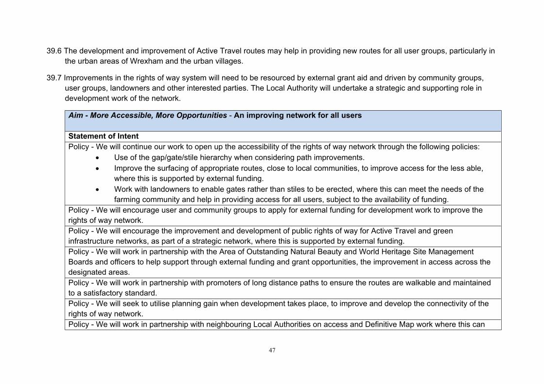
47
39.6 The development and improvement of Active Travel routes may help in providing new routes for all user groups, particularly in the urban areas of Wrexham and the urban villages.
39.7 Improvements in the rights of way system will need to be resourced by external grant aid and driven by community groups, user groups, landowners and other interested parties. The Local Authority will undertake a strategic and supporting role in development work of the network.
Aim - More Accessible, More Opportunities - An improving network for all users
Statement of IntentPolicy - We will continue our work to open up the accessibility of the rights of way network through the following policies:
Use of the gap/gate/stile hierarchy when considering path improvements. Improve the surfacing of appropriate routes, close to local communities, to improve access for the less able,
where this is supported by external funding. Work with landowners to enable gates rather than stiles to be erected, where this can meet the needs of the
farming community and help in providing access for all users, subject to the availability of funding.Policy - We will encourage user and community groups to apply for external funding for development work to improve the rights of way network.Policy - We will encourage the improvement and development of public rights of way for Active Travel and green infrastructure networks, as part of a strategic network, where this is supported by external funding.Policy - We will work in partnership with the Area of Outstanding Natural Beauty and World Heritage Site Management Boards and officers to help support through external funding and grant opportunities, the improvement in access across the designated areas. Policy - We will work in partnership with promoters of long distance paths to ensure the routes are walkable and maintained to a satisfactory standard.Policy - We will seek to utilise planning gain when development takes place, to improve and develop the connectivity of the rights of way network.Policy - We will work in partnership with neighbouring Local Authorities on access and Definitive Map work where this can

48
lead to efficiencies and a better rights of way network.
40 Aim - Better Information - Better information about the network and awareness of people’s responsibilities
Issue
40.1 Information is key to encouraging the local community to use the rights of way network, but it is also important to help tourists and visitors coming into Wrexham to be aware of how they can access our beautiful countryside.
40.2 Digital access to information has developed at a tremendous speed over the last ten years and is likely to continue to change as digital information and how people access it evolves.
40.3 User groups, such as the Ramblers Association, Walkabout Wrexham and North East Bridleways Association can disseminate information about the rights of way network to their members. Wrexham County Borough Council has a number of downloadable walks and riding routes and has developed Active Travel routes. It has also provided a copy of the Definitive Map on-line to help users wanting to access the map on-line.
40.4 The indication from the consultation amongst existing users was that, better information on where to walk, cycle or ride on the Council website was a lower priority, as was information on groups you could join to walk or ride in your area. This suggests the priority for any improvement in information should be targeted at people that don’t currently access the rights of way network, within the local community and visitors to the area. The Wales Outdoor Recreation Survey 2014, indicated “levels of outdoor visits in the last 4 weeks were least likely amongst people living in the 10% most deprived areas, not in paid employment, those with a household income below £15,500 a year and those resident in Community First areas”.
Aim - Better information - Better information about the network and awareness of people’s responsibilities.
Statement of IntentPolicy - We will continue to publish rights of way information on the Wrexham County Borough Council website, providing
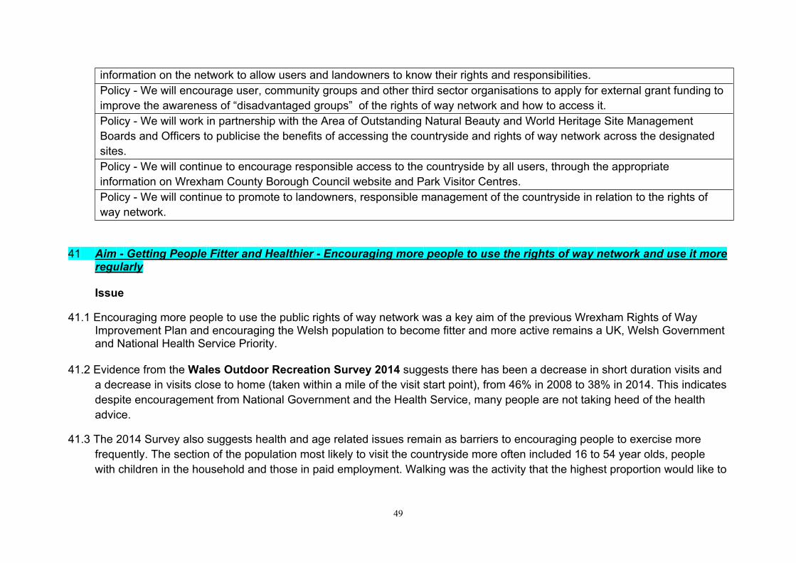
49
information on the network to allow users and landowners to know their rights and responsibilities.Policy - We will encourage user, community groups and other third sector organisations to apply for external grant funding to improve the awareness of “disadvantaged groups” of the rights of way network and how to access it. Policy - We will work in partnership with the Area of Outstanding Natural Beauty and World Heritage Site Management Boards and Officers to publicise the benefits of accessing the countryside and rights of way network across the designated sites.Policy - We will continue to encourage responsible access to the countryside by all users, through the appropriate information on Wrexham County Borough Council website and Park Visitor Centres.Policy - We will continue to promote to landowners, responsible management of the countryside in relation to the rights of way network.
41 Aim - Getting People Fitter and Healthier - Encouraging more people to use the rights of way network and use it more
regularly
Issue
41.1 Encouraging more people to use the public rights of way network was a key aim of the previous Wrexham Rights of Way Improvement Plan and encouraging the Welsh population to become fitter and more active remains a UK, Welsh Government and National Health Service Priority.
41.2 Evidence from the Wales Outdoor Recreation Survey 2014 suggests there has been a decrease in short duration visits and a decrease in visits close to home (taken within a mile of the visit start point), from 46% in 2008 to 38% in 2014. This indicates despite encouragement from National Government and the Health Service, many people are not taking heed of the health advice.
41.3 The 2014 Survey also suggests health and age related issues remain as barriers to encouraging people to exercise more frequently. The section of the population most likely to visit the countryside more often included 16 to 54 year olds, people with children in the household and those in paid employment. Walking was the activity that the highest proportion would like to
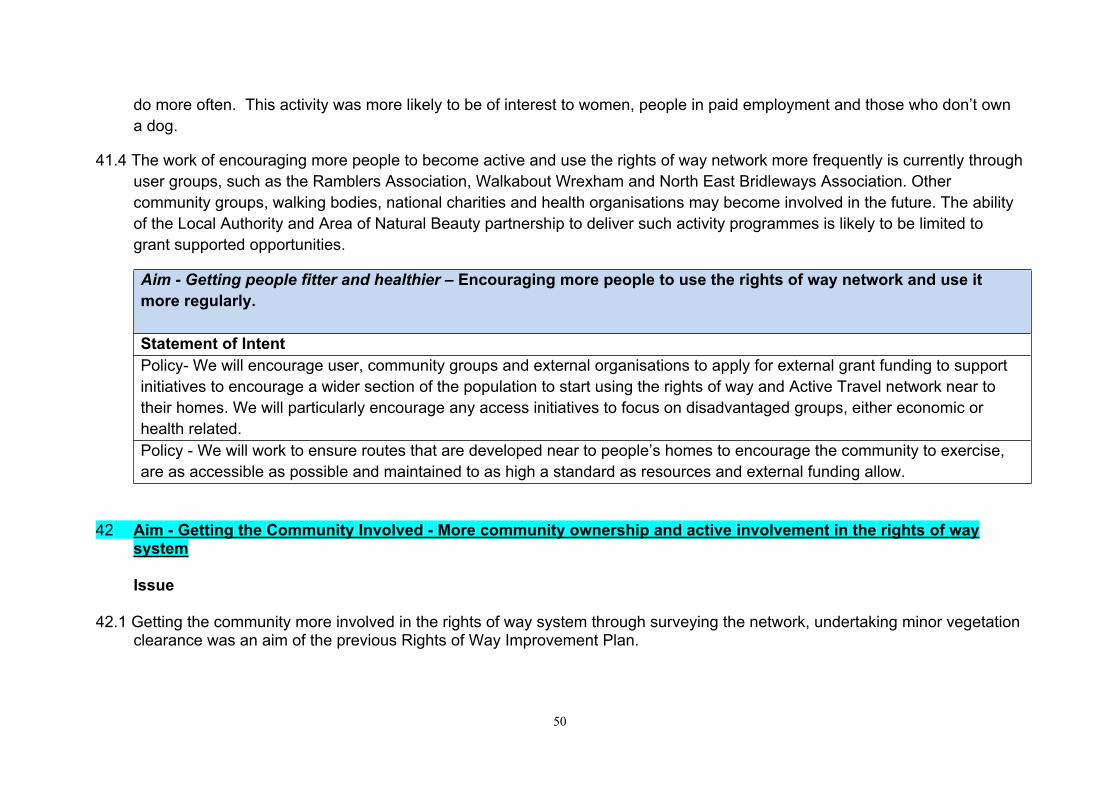
50
do more often. This activity was more likely to be of interest to women, people in paid employment and those who don’t own a dog.
41.4 The work of encouraging more people to become active and use the rights of way network more frequently is currently through user groups, such as the Ramblers Association, Walkabout Wrexham and North East Bridleways Association. Other community groups, walking bodies, national charities and health organisations may become involved in the future. The ability of the Local Authority and Area of Natural Beauty partnership to deliver such activity programmes is likely to be limited to grant supported opportunities.
Aim - Getting people fitter and healthier – Encouraging more people to use the rights of way network and use it more regularly.
Statement of IntentPolicy- We will encourage user, community groups and external organisations to apply for external grant funding to support initiatives to encourage a wider section of the population to start using the rights of way and Active Travel network near to their homes. We will particularly encourage any access initiatives to focus on disadvantaged groups, either economic or health related. Policy - We will work to ensure routes that are developed near to people’s homes to encourage the community to exercise, are as accessible as possible and maintained to as high a standard as resources and external funding allow.
42 Aim - Getting the Community Involved - More community ownership and active involvement in the rights of way system
Issue
42.1 Getting the community more involved in the rights of way system through surveying the network, undertaking minor vegetation clearance was an aim of the previous Rights of Way Improvement Plan.
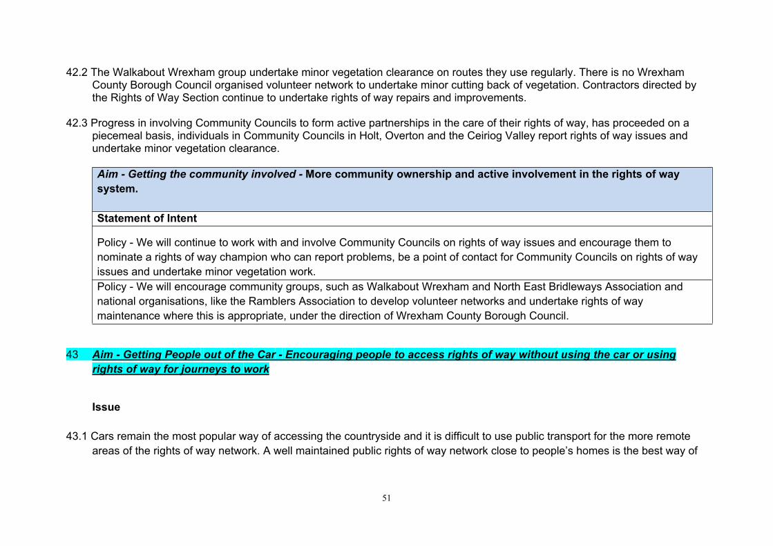
51
42.2 The Walkabout Wrexham group undertake minor vegetation clearance on routes they use regularly. There is no Wrexham County Borough Council organised volunteer network to undertake minor cutting back of vegetation. Contractors directed by the Rights of Way Section continue to undertake rights of way repairs and improvements.
42.3 Progress in involving Community Councils to form active partnerships in the care of their rights of way, has proceeded on a piecemeal basis, individuals in Community Councils in Holt, Overton and the Ceiriog Valley report rights of way issues and undertake minor vegetation clearance.
Aim - Getting the community involved - More community ownership and active involvement in the rights of way system.
Statement of Intent
Policy - We will continue to work with and involve Community Councils on rights of way issues and encourage them to nominate a rights of way champion who can report problems, be a point of contact for Community Councils on rights of way issues and undertake minor vegetation work. Policy - We will encourage community groups, such as Walkabout Wrexham and North East Bridleways Association and national organisations, like the Ramblers Association to develop volunteer networks and undertake rights of way maintenance where this is appropriate, under the direction of Wrexham County Borough Council.
43 Aim - Getting People out of the Car - Encouraging people to access rights of way without using the car or using rights of way for journeys to work
Issue
43.1 Cars remain the most popular way of accessing the countryside and it is difficult to use public transport for the more remote areas of the rights of way network. A well maintained public rights of way network close to people’s homes is the best way of

52
encouraging people to leave the car at home. The Active Travel Plan may encourage more people to travel to work or commute between communities without a car.
Aim - Getting people out of the car - Encouraging people to access rights of way without using the car or using rights of way for journeys to work
Statement of IntentPolicy- An Integrated Network Map of Active Travel Routes across the County Borough will be developed and implemented, subject to availability of external funding. This will provide the infrastructure to encourage more people to travel to work or commute between communities without a car.
44 Rights of Way Improvement Delivery Plan
44.1 The Rights of Way Improvement Plan is a strategic document for the 10 year period. It does not include timescales, budgets or specific projects. The Rights of Way Improvement Delivery Plan will set out in detail what the Local Authority will deliver with timescales, targets and budget. This is likely to be an annual plan.
45 Funding
45.1 The first Rights of Way Improvement Plan was an ambitious 10 year strategy to develop and improve public rights of way in Wrexham. There were difficult and stretching targets in the plan which required additional external funding. The work for the 2007 strategy was supported throughout the plan period by Welsh Government funding. This enabled delivery of many of the targets and significant improvements in the condition of the network.
45.2 Welsh Government have indicated they will not be supporting the new Rights of Way Improvement Plans in Wales with grant funding. This coupled with the reduction in staffing resources in the Rights of Way Section means the new plan is a less ambitious document.

53
45.3 Improvements in the network, developmental and promotional work must come from external funding, sourced and delivered mainly by external groups and organisations.
45.4 Core funding for the statutory duties of maintenance of the rights of way network and managing the definitive map will continue to be supported by Wrexham County Borough Council.
46 Monitoring and Evaluation
The progress in delivering the plan will monitored by the Local Access Forum and Wrexham County Borough Council Members.
References
Review of Statement of Action, Rights of Way Improvement Plan 2017
Consultation Results Following Consultation On Draft Rights of Way improvement Plan 2018
The Well-Being of Future Generations (Wales) Act 2015
Environment (Wales) Act (2016)
Natural Resources Policy (2017)
Wrexham County Borough Council Plan 2017-22
Wrexham’s Well-Being Plan, Wrexham Public Service Board
Active Travel Plan
Wrexham Local Development Plan 2 (LDP2) 2013-2028

54