Embed Size (px)
Citation preview
www.digitalglobe.com Corporate (U.S.) +1.303.684.4561 or +1.800.496.1225 | London +44.20.8899.6801 | Singapore +65.6389.4851
DATA SHEE T
Features » Very high resolution
» The most spectral diversity commercially available - 4 standard colors: blue, green, red,
near-IR1
- 4 new colors: coastal, yellow, red edge, and near-IR2
» Industry-leading geolocation accuracy
» High capacity over a broad range of collection types
» Bi-directional scanning
» Rapid retargeting using Control Moment Gyros (>2x faster than any competitor)
» Direct downlink to customer sites available
» Frequent revisits at high resolution
Benefits » Provides highly detailed imagery
for precise map creation, change detection, and in-depth image analysis
» Geolocate features to less than 5 m to create maps in remote areas, maximizing the utility of available resources.
» Collects, stores, and downlinks a greater supply of frequently updated global imagery products than competitive systems
» Stereoscopic collection on a single pass, ensures image continuity and consistency of quality
» Provides the ability to perform precise change detection, mapping and analysis at unprecedented resolutions in 8-band multispectral imagery
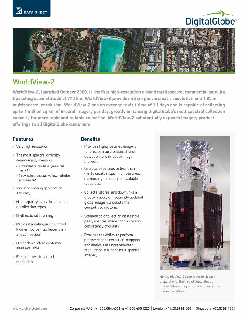
WorldView-2WorldView-2, launched October 2009, is the first high-resolution 8-band multispectral commercial satellite. Operating at an altitude of 770 km, WorldView-2 provides 46 cm panchromatic resolution and 1.85 m multispectral resolution. WorldView-2 has an average revisit time of 1.1 days and is capable of collecting up to 1 million sq km of 8-band imagery per day, greatly enhancing DigitalGlobe’s multispectral collection capacity for more rapid and reliable collection. WorldView-2 substantially expands imagery product offerings to all DigitalGlobe customers.
New WorldView-2 clean room pre-launch
preparations. The third of DigitalGlobe’s
state-of-the-art high-resolution commercial
imagery satellites.

www.digitalglobe.com Corporate (U.S.) +1.303.684.4561 or +1.800.496.1225 | London +44.20.8899.6801 | Singapore +65.6389.4851
DIGITALGLOBE CONSTEL L ATION » WORL DVIE W-2
DATA SHEE T
DS-WV2 02/16
Altitude and slew timeDesign specifications
All imagery complies with U.S. regulation.
Launch Information Date: October 8, 2009Launch Vehicle: Delta 7920 (9 strap-ons)Launch Site: Vandenberg Air Force Base, California
Orbit Altitude: 770 kmType: Sun synchronous, 10:30 am descending nodePeriod: 100 min.
Mission Life 10-12 years, including all consumables and degradables (e.g. propellant)
Spacecraft Size, Mass and Power
5.7 m (18.7 ft) tall x 2.5 m (8 ft) across7.1 m (23 ft) across the deployed solar arrays2615 kg (5765 lbs)3.2 kW solar array, 100 Ahr battery
Sensor Bands Panchromatic: 450 - 800 nm8 Multispectral: Coastal: 400 - 450 nm Red: 630 -690 nmBlue: 450 - 510 nm Red Edge: 705 - 745 nmGreen: 510 - 580 nm Near-IR1: 770 - 895 nmYellow: 585 - 625 nm Near-IR2: 860 - 1040 nm
Sensor Resolution Panchromatic: 0.46 m GSD at nadir, 0.52 m GSD at 20° off-nadirMultispectral: 1.85 m GSD at nadir, 2.07 m GSD at 20° off-nadir
Dynamic Range 11-bits per pixel
Swath Width 16.4 km at nadir
Attitude Determination and Control
3-axis stabilizedActuators: Control Moment Gyros (CMGs)Sensors: Star trackers, solid state IRU, GPS
Pointing Accuracy and Knowledge
Accuracy: <500 m at image start and stopKnowledge: Supports geolocation accuracy below
Retargeting Agility Time to Slew 200 km: 10 sec
Onboard Storage 2199 Gb solid state with EDAC
Communications Image and Ancillary Data: 800 Mbps X-bandHousekeeping: 4, 16 or 32 kbps real-time, 524 kbps stored, X-bandCommand: 2 or 64 kbps S-band
Max Contiguous Area Collected in a Single Pass(30° off-nadir angle)
Mono: 138 x 112 km (8 strips)Stereo: 63 x 112 km (4 pairs)
Revisit Frequency(at 40°N Latitude)
1.1 days at 1 m GSD or less3.7 days at 20° off-nadir or less (0.52 m GSD)
Geolocation Accuracy (CE90)
Demonstrated <3.5 m CE90 without ground control
Capacity 1 million km2 per day
LARGE AREACOLLECT
MULTIPLE POINTTARGETS
STEREO AREACOLLECT
LONG STRIP
360 km
16.4 km
16.4 km
16.4 km
112 km
63 km
112 km
138 km
Altitude770 km
10 seconds
200 km
Collection scenarios (300 off-nadir angle)
Panchromatic
Multispectral
Sensor bands
4 additional bands