Embed Size (px)
Citation preview
123
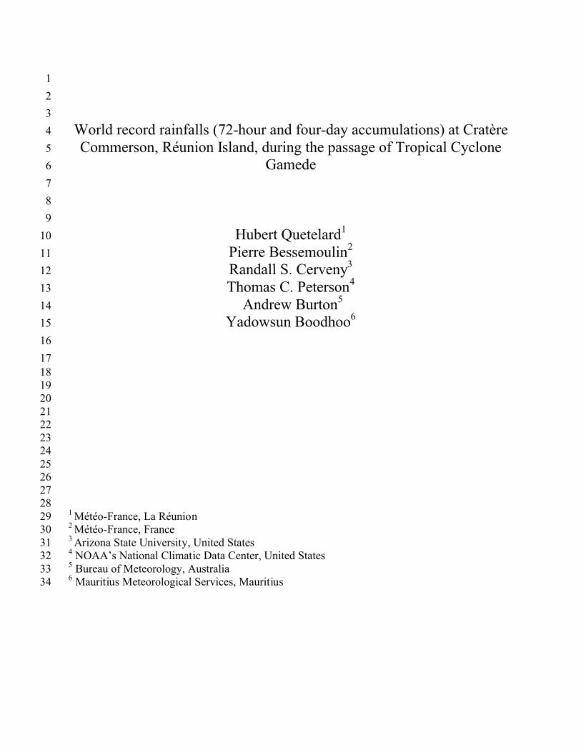
World record rainfalls (72-hour and four-day accumulations) at Cratère 4Commerson, Réunion Island, during the passage of Tropical Cyclone 5
Gamede6789
Hubert Quetelard110Pierre Bessemoulin211Randall S. Cerveny312Thomas C. Peterson413
Andrew Burton514Yadowsun Boodhoo615
16171819202122232425262728
1 Météo-France, La Réunion292 Météo-France, France303 Arizona State University, United States314 NOAA’s National Climatic Data Center, United States325 Bureau of Meteorology, Australia336 Mauritius Meteorological Services, Mauritius34
ABSTRACT1
The World Meteorological Organization (WMO) Commission for Climatology (CCl) 2
evaluation process is applied to two extreme rainfall records occurring at Cratère Commerson on 3
La Réunion Island during the passage of the major Tropical Cyclone (TC) Gamede for inclusion 4
into the WMO CCl World Weather and Climate Extremes Archive. In February 2007, TC 5
Gamede made two approaches to La Réunion Island as it traversed a rather complex path in the 6
Indian Ocean. Gamede’s main feature was massive rainfall accumulation inland, with several 7
three- and four-day rainfall totals exceeding two meters. Specifically, an extreme rainfall rate of 8
3929 mm over 72 hours was recorded at Cratère Commerson, well above previous world record9
of 3240 mm which had been measured at Grand-Ilet during TC Hyacinthe in 1980. Additionally, 10
the Cratère Commerson raingauge registered a rainfall total of 4869 mm over four days; also 11
well above the previous world record. The evaluation committee found consistent regional 12
rainfall measurements, reliable calibrated equipment, and correct recording procedures were 13
followed throughout the event. Problems with potential wind-induced measurement errors were 14
discussed but the committee consensus is that such errors tend to under- rather than over-15
estimate rainfall accumulations. As shown by analysis of this event, the validation process for 16
the WMO CCl Weather and Climate Extremes Archive provides essential documentation and 17
certification for weather extremes across the world.18
1. Introduction1
A critical aspect of identifying climate change is the establishment and maintenance of 2
verifiable weather data of weather and climate extremes (Cerveny et al., 2007). Since reported 3
incidents of weather extremes are often used as indicators that the Earth’s climate is changing 4
and/or becoming more variable, confirmation of new weather extreme records should be 5
recognized as a high priority in the meteorology community. Although several countries across 6
the world have initiated weather and climate extremes committees (e.g., U.S. National Climate 7
Extremes Committee, see http://www.ncdc.noaa.gov/oa/climate/monitoring/extremes/ncec.html) 8
to identify, verify and archive weather extremes within their own borders, until recently similar 9
measures for documenting and archiving world weather extremes have not been established. In 10
2006, the World Meteorological Organization (WMO) Commission for Climatology (CCl) 11
appointed a Rapporteur on Climate Extremes to launch and maintain an official, unbiased list of 12
weather and climate extremes for the world and, additionally, to establish procedures for the 13
verification of future weather records.14
Upon receipt of a new purported record, an ad hoc extremes committee is organized to 15
provide an expert and unbiased recommendation whether the extreme in question should be 16
added to the list. The committee consists of the President of the Commission for Climatology, 17
the Chair of the CCl Open Programme Area Group (OPAG) on Monitoring and Analysis of 18
Climate Variability and Change (the Rapporteur is part of this OPAG), and a representative of 19
the relevant Member State’s National Meteorological and Hydrologic Service as well as experts 20
in the appropriate meteorological phenomenon and observing instrumentation as required. The 21
committee may also consult with a wide variety of additional experts as the need arises. Based 22
on the available data from the event, the committee creates an evaluation and recommendation 23
for the Rapporteur of Climate Extremes, who then makes a judgment of the record’s inclusion 1
into the WMO CCl World Weather and Climate Extremes Archive.2
A critical aspect of the committee’s evaluation process is to ascertain potential errors 3
arising in the recording of the purported weather extreme. For example, a recent report (Dhar 4
and Nandargi, 2006) indicated that on 10 June 2003 Cherrapunji, India, recorded a daily (24-5
hour) rainfall total of 1840 mm, which would have been a new world record. However, upon 6
examination, an investigation conducted by Dr. Rupa Kumar Kolli at the request of the 7
Rapporteur proved that the published value was a misprint and that no 24-hour rainfall record 8
had been achieved at Cherrapunji for that date.9
10
2. Tropical Cyclone Gamede11
We detail in this paper the investigation of two possible new world record rainfall events 12
associated with the passage of a tropical cyclone in the South Indian Ocean. Recently, in 13
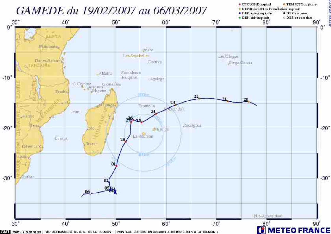
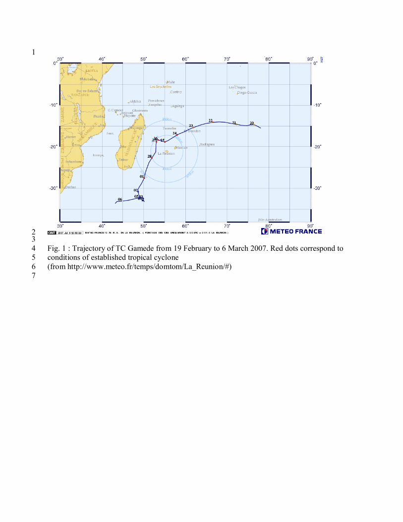
February of 2007, the major tropical cyclone, Gamede, made two approaches to the island of La 14
Réunion as it traversed a complex looping path in the Indian Ocean (Fig. 1). During the first 15
passage, at a distance slightly more than 200 km northwest of the island on Saturday, the 24th of 16
February 2007, winds first oriented from east-southeast veered progressively to east-northeast on 17
Sunday, the 25th of February. They were particularly strong in the highlands and over northern 18
and southern coasts. Heavy rains started over the island’s main volcano (Piton de la Fournaise) 19
during the night from the 23th to the 24th, extending then progressively to the whole highlands. 20
Rainfall was more irregular at the coast, because of the succession of peripheral rain bands 21
associated with the whole system. Following this first passage, TC Gamede moved away along a 22
complicated trajectory involving two successive loops, and a prolonged stop on the evening of 23
Monday the 26th of February. Despite the distance (400 km) to the TC’s center, storm conditions 1
over the island remained intense, with heavy rain continuing, especially in the highlands, and 2
strong winds blowing from the east-northeast.3
During a second close passage, to within 250 km west of the island on Tuesday (27 4
February) evening, while the cyclone was moving south, winds turned from north-east to north-5
north-east, and again strengthened over the highlands, so the western part of the island was hit in 6
its turn. Rainfall intensity decreased close to the coast, but remained heavy in the highlands. It is 7
only on morning of the 28th that conditions improved across the entire island as the system 8
moved away to the southwest.9
10
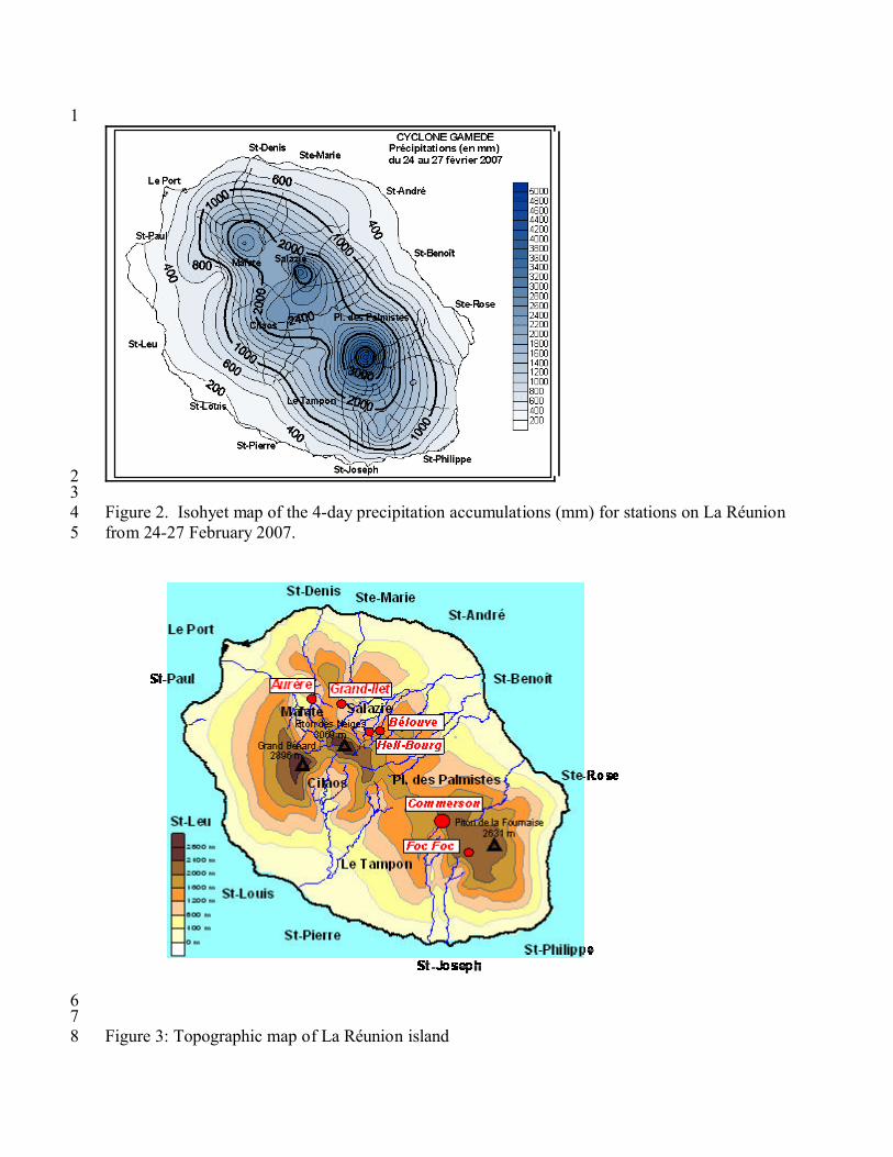
3. TC Gamede Precipitation over La Réunion11
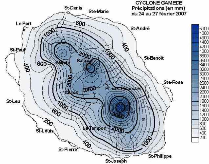
The main feature of TC Gamede was a huge amount of rainfall inland, with several 3- and 12
4-day rainfall totals over two meters across the island (Table 1). Rainfall was not associated 13
with any extreme intensity peaks, but the cumulative totals over periods of 12 hours and more 14
reached remarkable, even exceptional levels in the high altitude sites of Salazie and Cilaos and 15
over the volcano (Figure 1).16
It is important to note that the accumulated rainfalls mentioned in this chapter are 17
sometimes differing from the sums of daily totals appearing in Table 1, which correspond to 18
fixed time intervals starting and ending at 03UTC (07 local time). The accumulated rainfall 19
amounts mentioned in the table are the maximum running totals beginning at 01,02, to 23 hours 20
(all times mentioned are local time: UTC+4) over periods of 24, 48, 72, 96 hours.21
Specifically, the highest of 24 hour rainfall amount of 1625 mm was recorded at Cratère 22
Commerson from 15h on the 24th to 15h on the 25th, which is somewhat less than the current 23
world record of 1825 mm measured at Foc-Foc during TC Denise in 1966 (Krause and Flood, 1
1997), while additional impressive amounts of 1489 mm (from 21h on the 24th to 21h on the 2
25th) and 1295 mm (from 23h on the 24th to 23h on the 25th) were measured at Hell-Bourg and 3
Bélouve, respectively. Even more impressively, over 48 hours, a rainfall total of 2463 mm at 4
Cratère Commerson was recorded from 07h on the 24th to 07h on the 26th, very close to the 5
world record of 2467 mm at Aurère during an unnamed TC (8-10 April 1958) (Holland, 1993). 6
Other extreme precipitation values included 2358 mm at Hell-Bourg over 48 hours (from 22h on 7
the 24th to 22h on the 26th) and 2185 mm at Bélouve (from 23h on the 24th to 23h on the 26th) 8
over the same time period.9
Most importantly, an extreme rainfall of 3929 mm over 72 hours (from 16h on the 24th to 10
16h on the 27th) was recorded at Cratère Commerson and a rate of 3264 mm over the same time 11
period at Hell-Bourg (from 14h on the 24th to 14h on the 27th). Both of these values are well 12
above previous world record of 3240 mm over 72 hours which had been measured at Grand-Ilet 13
(see location Fig. 3) during tropical cyclone Hyacinthe in 1980 (Cerveny et al., 2007; Krause and 14
Flood, 1997). Somewhat smaller, but still impressive rainfall totals of 2824 mm and 2321 mm 15
over 72 hours were recorded at Bélouve and Cilaos, respectively.16
New world records associated with this event have also been established for rainfall totals 17
over a four-day interval. The Cratère Commerson raingauge registered a rainfall total of 4869 18
mm over four days while a rainfall amount of 3633 mm was recorded at Hell-Bourg. These two 19
values are well above previous world record of 3551 mm at Cratère Commerson during TC 20
Hyacinthe in 1980 (Cerveny et al., 2007; Krause and Flood, 1997). Other high rainfall values 21
recorded on La Réunion during TC Gamede included 3139 mm at Bélouve and 2586 mm at 22
Cilaos.23
Additionally, although these categories are not yet a part of the official WMO weather 1
and climate archive, new world records were also established for rainfall totals over 5, 6, 7, 8 and 2
9 days with respectively 4979 mm, 5075 mm, 5400 mm, 5510 mm and 5512 mm at this same 3
location (Cratère Commerson). 4
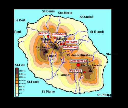
The Commerson station is located north of the volcano at 21°12.48’ S and 55° 38.62’ E 5
and is 2310 m above sea-level. It became operational on 1st January 1968. The local 6
environment of the station is very open, which is relatively unusual at La Réunion due to the 7
island’s mountainous topography and vegetation. The instrumentation used to measure the 8
rainfall at this location was a Précis-Mécanique Tipping Bucket Raingauge, type 3020, (20 g 9
plastic buckets) with an aperture of 400 cm², installed at the site in May 2004.10
Logs of maintenance and sensor calibration indicate that the raingauge had been 11
calibrated not long before the event (4 December 2006) and was rechecked on 9 January 2007. 12
Following the passage of TC Gamede, the raingauge was again examined on 10 April 2007. No13
problems with calibration were discovered.14
One of the critical missions of the ad hoc investigation committee was to ascertain if 15
there could be any anomalies in the manner in which data were collected. In this case, according 16
to the person responsible for the climatological network in La Réunion, there is no objective 17
reason to question measurements made at this site. The equipment was, and is, well protected 18
inside an impervious aluminium cylinder, and well fixed to the ground. Numerous studies have 19
demonstrated that wind induces a loss of precipitation measured by the raingauge (e.g., Chvila et 20
al., 2005; World Meteorological Organization 2006). Indeed, a comparison by one of the 21
committee members (Y. Boodhoo) of co-located wind shielded and non-shielded precipitation 22
measurements taken during the passage of TC Gamede at nearby Mauritius (Station Vacoas) 23
reveals that the shielded raingauge received more rainfall (11 mm over the course of 6 days from 1
February 21st to the 27th) in excess than its unshielded counterpart. Because the precipitation 2
gauge is not shielded, it is considered likely that the record values observed at Cratère 3
Commerson are conservative totals of the rainfall.4
Tropical cyclones are affecting La Réunion Island from December to April, during the 5
hot season, with a maximum probability in January and February. Statistically, a significant 6
event is affecting the island every five to ten years, but it is not impossible to observe this type of 7
phenomena during two consecutive years (e.g. Colina in 1993, Hollanda in 1994). Over the 2-3 8
days when the cyclone generally affects La Réunion weather, typical rainfall range from 300 to 9
600 mm close to the coast, from 1000 to 1500 mm in the highlands (even much more in some 10
cases). Tropical cyclone precipitation always starts in the highlands of La Réunion as a result of 11
the extreme orography (70% of the island lies between altitudes from 400m to 3069m, see Fig. 12
3). At the end of a TC passage, again due to orographic uplift, precipitation tends to continue in 13
the highlands even as the lowland rains have stopped. Consequently, it is not surprising that the 14
highlands of the island recorded the greatest rainfall amounts (Figure 2). It is normal during 15
tropical cyclone passages for the Commerson site, which is at high elevation, to receive the 16
highest quantities of any observing site on the island (Table 1). In addition, because of its 17
geographical position, the orographic effect at Commerson is at a maximum, no matter what the 18
wind direction. This is not true for other stations in the highlands, where this orographic effect is 19
dependent on the wind direction.20
21
4. Summary and Conclusions22
In summary, a fairly even distribution of rain was observed over the four days for more 1
than half of the island stations and, on the 24th, the two highest sites, Commerson and 2
Bellecombe, received the greatest rainfall total with comparable values. On the 25th and 26th, 3
comparable daily rainfall rates were again observed at Commerson, Hell-Bourg and Bélouve. 4
On the 27th, rainfall rates were decreasing at stations in the northern half of the island, while 5
keeping the same order of magnitude in the southern half.6
Even if one can question the behaviour of raingauges in such extreme conditions (a 7
general concern for verification of rainfall extremes), it appears that the observed record rainfalls 8
are indeed credible. Under strong winds, errors in tipping bucket raingauge measurements tend 9
to be underestimates rather than overestimates because of aerodynamic effects around the 10
instrument. However, it should be noted that the previous official world record rainfall values at 11
La Réunion (at Commerson for most of them) were recorded with the same type of raingauges.12
Consequently, it was the recommendation of the committee and subsequent approval of 13
the Rapporteur, that two new world rainfall records have been established at La Réunion 14
associated with the passage of the intense TC Gamede. First, an extreme rainfall rate of 3929 15
mm over 72 hours as recorded at Cratère Commerson is now the new 72-hour world rainfall 16
total. Second, a new world rainfall record is established for the Cratère Commerson raingauge 17
when it registered a rainfall total of 4869 mm over a four-day period. These records are now a 18
part of the WMO World Weather and Climate Archive currently housed at http://wmo.asu.edu/19
As the perception or the actual occurrence of more frequent extreme weather events 20
grows, the goal of WMO World Weather and Climate Extremes database is to archive and verify 21
extreme record events, such as the highest/lowest recorded temperatures and pressures on the 22
Earth, the strongest winds, the greatest precipitation (over different time intervals) as well as 23
records involving the world’s most destructive storms, hurricanes and tornadoes. In the past, 1
without the existence of such an official designate to determine and maintain regional or world 2
records of extreme weather events, the critical supportive documentation needed to assess the 3
validity of a weather record event was often hard to find or simply did not exist. The WMO CCl 4
Extreme Weather and Climate Archive, together with the procedures for evaluating potential 5
new records, now provides the essential documentation and certification for weather extremes 6
across the world.7
8
9Acknowledgements: The authors thank the members of WMO CCl Open Programme Area 10
Group (OPAG) on Monitoring and Analysis of Climate Variability and Change (see 11
http://www.wmo.int/pages/prog/wcp/ccl/index_en.html) for their support and input to the 12
formation of the Archive.13
References:12
Cerveny, R.S., J. Lawrimore, R. Edwards and C. Landsea, 2007: Extreme Weather Records: 3
Compilation, Adjudication and Publication. Bulletin of the American Meteorological 4
Society. 88 (6): 853-860.5
Chvila, B., B. Sevruk, and M. Ondras, 2005: The wind-induced loss of thunderstorm 6
precipitation measurements. Atmospheric Research. 77(1-4):29-38.7
Dhar, O.N. and S. Nandargi, 2006: Cherrapunji breaks the world precipitation record for one-8
day duration. Int. J. of Meteor.. 31:146-147.9
Holland, G.J. (1993): "Ready Reckoner" - Chapter 9, _Global Guide to Tropical Cyclone 10
Forecasting. WMO/TD-No. 560, Report No. TCP-31, World Meteorological 11
Organization, Geneva, Switzerland. 12
Krause, P.F. and K.L. Flood, 1997: Weather and Climate Extremes, TEC-0099, US Army Corps 13
of Engineers Topographic Engineering Center, Alexandra VA, 89 pp.14
World Meteorological Organization, 2006: Guide to Meteorological Instruments and Methods of 15
Observation. WMO-No.8, World Meteorological Organization, Geneva, Switzerland, 16
569 pp.17
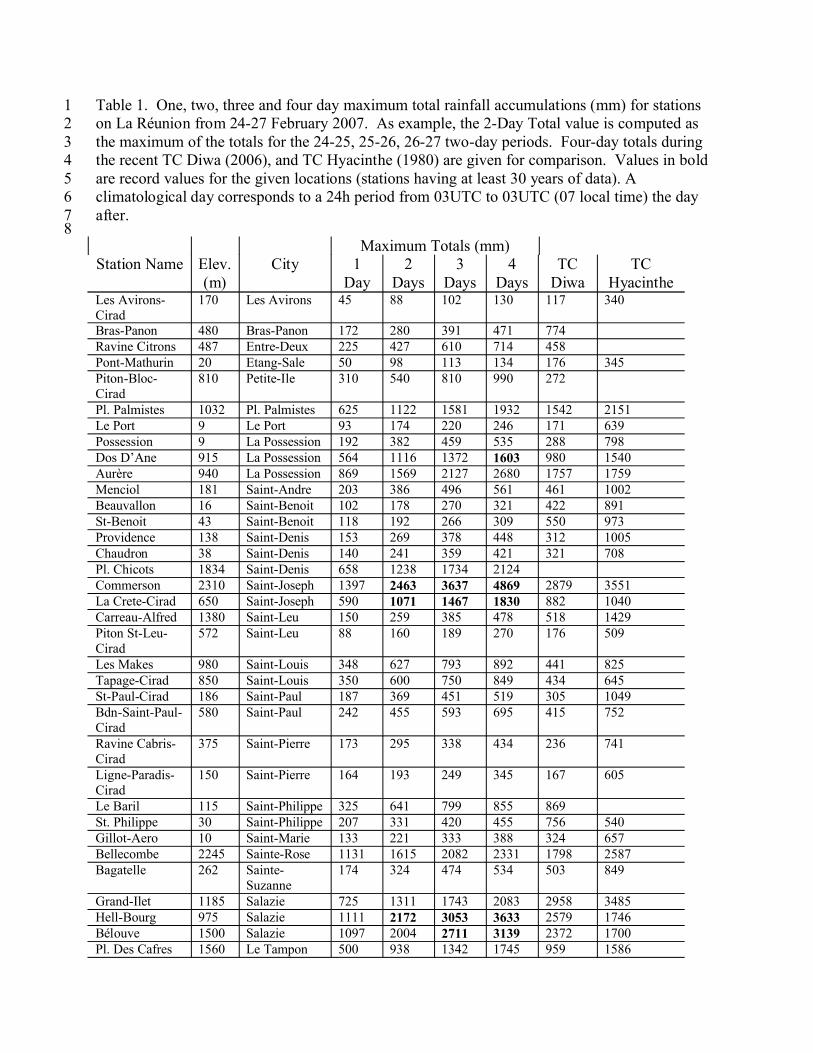
Table 1. One, two, three and four day maximum total rainfall accumulations (mm) for stations 1on La Réunion from 24-27 February 2007. As example, the 2-Day Total value is computed as 2the maximum of the totals for the 24-25, 25-26, 26-27 two-day periods. Four-day totals during 3the recent TC Diwa (2006), and TC Hyacinthe (1980) are given for comparison. Values in bold 4are record values for the given locations (stations having at least 30 years of data). A 5climatological day corresponds to a 24h period from 03UTC to 03UTC (07 local time) the day 6after.7
8Maximum Totals (mm)
Station Name Elev.(m)
City 1 Day
2 Days
3 Days
4 Days
TC Diwa
TC Hyacinthe
Les Avirons-Cirad
170 Les Avirons 45 88 102 130 117 340
Bras-Panon 480 Bras-Panon 172 280 391 471 774Ravine Citrons 487 Entre-Deux 225 427 610 714 458Pont-Mathurin 20 Etang-Sale 50 98 113 134 176 345Piton-Bloc-Cirad
810 Petite-Ile 310 540 810 990 272
Pl. Palmistes 1032 Pl. Palmistes 625 1122 1581 1932 1542 2151Le Port 9 Le Port 93 174 220 246 171 639Possession 9 La Possession 192 382 459 535 288 798Dos D’Ane 915 La Possession 564 1116 1372 1603 980 1540Aurère 940 La Possession 869 1569 2127 2680 1757 1759Menciol 181 Saint-Andre 203 386 496 561 461 1002Beauvallon 16 Saint-Benoit 102 178 270 321 422 891St-Benoit 43 Saint-Benoit 118 192 266 309 550 973Providence 138 Saint-Denis 153 269 378 448 312 1005Chaudron 38 Saint-Denis 140 241 359 421 321 708Pl. Chicots 1834 Saint-Denis 658 1238 1734 2124Commerson 2310 Saint-Joseph 1397 2463 3637 4869 2879 3551La Crete-Cirad 650 Saint-Joseph 590 1071 1467 1830 882 1040Carreau-Alfred 1380 Saint-Leu 150 259 385 478 518 1429Piton St-Leu-Cirad
572 Saint-Leu 88 160 189 270 176 509
Les Makes 980 Saint-Louis 348 627 793 892 441 825Tapage-Cirad 850 Saint-Louis 350 600 750 849 434 645St-Paul-Cirad 186 Saint-Paul 187 369 451 519 305 1049Bdn-Saint-Paul-Cirad
580 Saint-Paul 242 455 593 695 415 752
Ravine Cabris-Cirad
375 Saint-Pierre 173 295 338 434 236 741
Ligne-Paradis-Cirad
150 Saint-Pierre 164 193 249 345 167 605
Le Baril 115 Saint-Philippe 325 641 799 855 869St. Philippe 30 Saint-Philippe 207 331 420 455 756 540Gillot-Aero 10 Saint-Marie 133 221 333 388 324 657Bellecombe 2245 Sainte-Rose 1131 1615 2082 2331 1798 2587Bagatelle 262 Sainte-
Suzanne174 324 474 534 503 849
Grand-Ilet 1185 Salazie 725 1311 1743 2083 2958 3485Hell-Bourg 975 Salazie 1111 2172 3053 3633 2579 1746Bélouve 1500 Salazie 1097 2004 2711 3139 2372 1700Pl. Des Cafres 1560 Le Tampon 500 938 1342 1745 959 1586
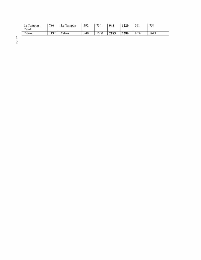
Le Tampon-Cirad
786 Le Tampon 392 734 948 1220 561 754
Cilaos 1197 Cilaos 840 1550 2185 2586 1632 164312
1
23
Fig. 1 : Trajectory of TC Gamede from 19 February to 6 March 2007. Red dots correspond to 4conditions of established tropical cyclone5(from http://www.meteo.fr/temps/domtom/La_Reunion/#)6
7
1
23
Figure 2. Isohyet map of the 4-day precipitation accumulations (mm) for stations on La Réunion 4from 24-27 February 2007.5
67
Figure 3: Topographic map of La Réunion island8