Embed Size (px)
Citation preview

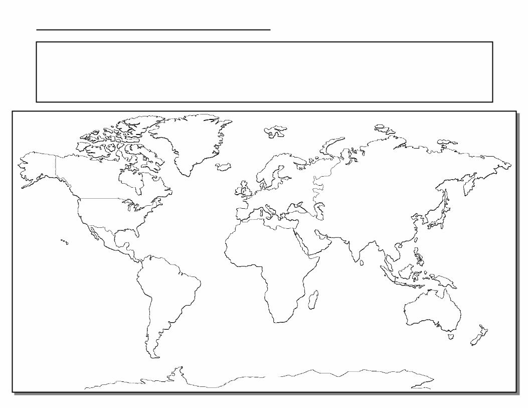
World Geography Copywork Copyright ©2015 Homeschool Giveaways
This copywork pack is intended to enhance your child's knowledge of World Geography. It is not a Geography Curriculum or a complete Geography study and therefore, is not inclusive of all Geography facts. When researching facts, there were so many things I wanted to place on each map that I had to be careful not to over crowd them or they wouldn't be legible for copying. I sorted through all the information and only included facts that are the most important, the largest, the longest, the most well-known, or the must-know of each map topic. These facts will enhance the learning your child is already getting from their Geography program. I recommend that your child copy the names of the continents and oceans on every map they produce. This will help them quickly learn the most important basic facts. I also recommend that when copying the maps with color distributions, have your child copy one color at a time so they can see the distribution of that particular item on the map, for example, Mineral Distributions Map - color all of the iron shapes first so the child will see where all the iron deposits are located around the world and proceed with each mineral until complete. Credits and Acknowledgments Author - Janeen Herlugson of Sprouting Tadpoles, created for Homeschool Giveaways. Cover designed by Richele McFarlin of Crisp Apple Design. Graphics by Zip-A-Dee-Doo-Dah Designs.
© Copyright 2015 Homeschool Giveaways. Original subscriber is granted permission to photocopy pages for use within their single family. All other rights reserved. You are not allowed to post this file, link directly to this file, or re-
distribute this file by any means.
north
America
south
America
Asia
Europe
Antarctica
Australia
Africa
Pacific Ocean
Indian Ocean
Atlantic Ocean
Pacific Ocean
Arctic Ocean Arctic Ocean
Southern Ocean
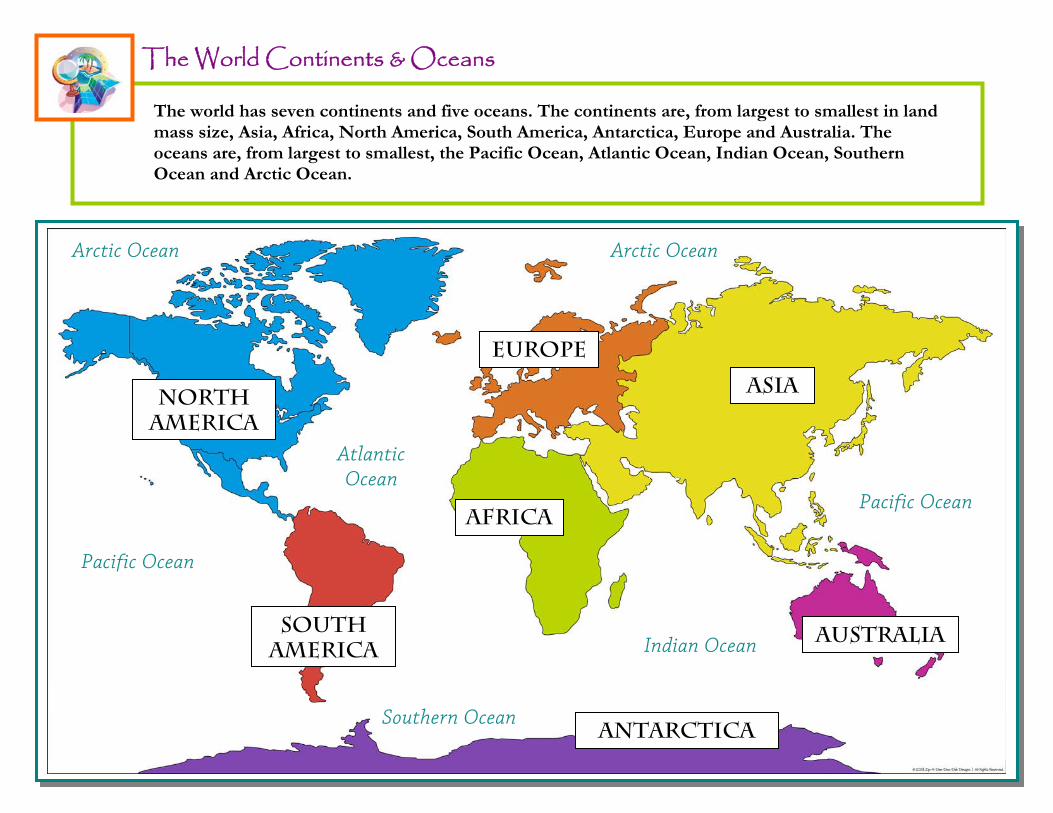
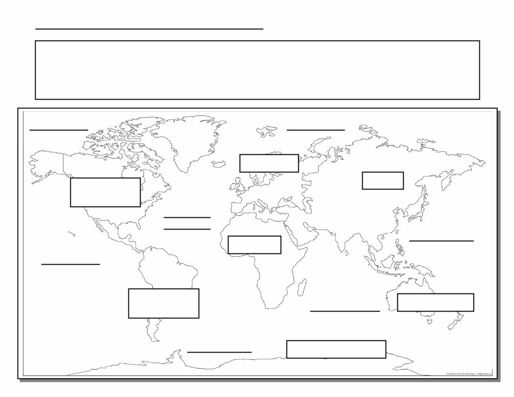
The World Continents & Oceans
The world has seven continents and five oceans. The continents are, from largest to smallest in land mass size, Asia, Africa, North America, South America, Antarctica, Europe and Australia. The oceans are, from largest to smallest, the Pacific Ocean, Atlantic Ocean, Indian Ocean, Southern Ocean and Arctic Ocean.
2

3
Pri
me
Mer
idia
n 1
80°
Equator 0°
Tropic of Cancer 23°N
Tropic of Capricorn 23°S Lines of Latitude run east to west
Arctic Circle 66°N
Antarctic Circle 66°S
Line
s of
Long
itude
run
nort
h to
sout
h
EA
STE
RN
HE
MIS
PH
ER
E
WE
STE
RN
HE
MIS
PH
ER
E
NORTHERN HEMISPHERE
SOUTHERN HEMISPHERE
North Pole 90°N
South Pole 90°S
The World's Great Lines & Divisions
Lines of latitude run parallel to the equator around the earth's surface with the equator being designated at 0° parallel. The equator also separates the Northern and Southern Hemispheres. The Prime Meridian separates the Eastern and Western Hemisphere and is located at 180°. The combination of these two components specifies the position of any location on the surface of the earth.
4
-
5
TransAntarctic Mountains
The Himalayas
Andes Mountains
Pacific Ocean
Indian Ocean
Atlantic Ocean
Pacific Ocean
Arctic Ocean Arctic Ocean
Southern Ocean
Africa
Asia Europe
Australia
Antarctica
Atlas Mountains
Great Dividing Range
Kunlun Mountains
South America
Rocky Mountains
North America
Ural Mountains
Appalachian Mountains
The Alps
Mt. Everest Mt. Fuji Cascade Range
Mt. St. Helens
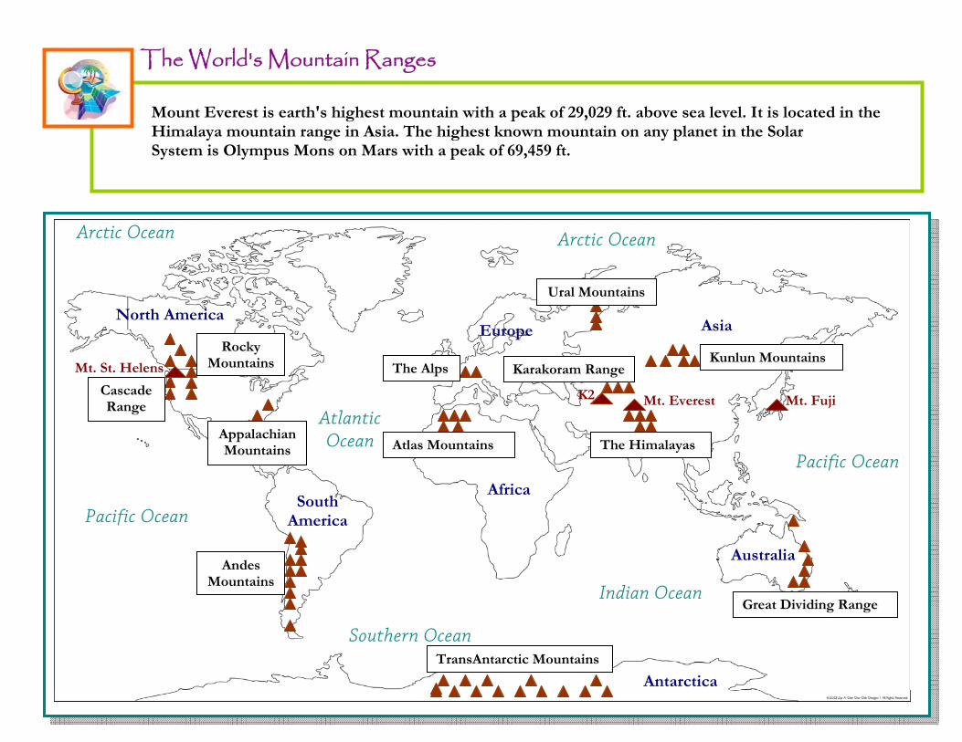
The World's Mountain Ranges
Mount Everest is earth's highest mountain with a peak of 29,029 ft. above sea level. It is located in the Himalaya mountain range in Asia. The highest known mountain on any planet in the Solar System is Olympus Mons on Mars with a peak of 69,459 ft.
Karakoram Range
K2
6
7
Pacific Ocean
Indian Ocean
Atlantic Ocean
Pacific Ocean
Arctic Ocean Arctic Ocean
Southern Ocean
Africa
Asia
Europe
Australia
Antarctica
South America
North America
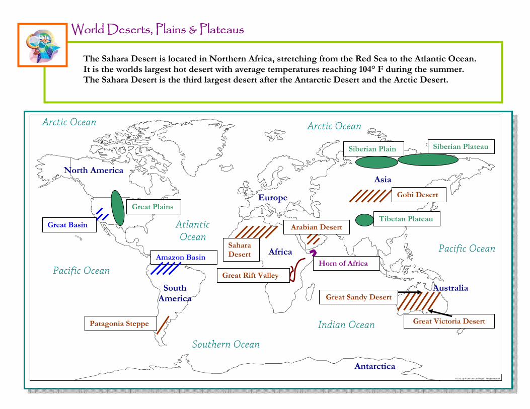
Tibetan Plateau
Gobi Desert
Siberian Plateau Siberian Plain
Arabian Desert
Amazon Basin
Patagonia Steppe
Sahara Desert
Great Plains
Great Basin
Great Victoria Desert
Great Sandy Desert
Great Rift Valley
Horn of Africa
World Deserts, Plains & Plateaus
The Sahara Desert is located in Northern Africa, stretching from the Red Sea to the Atlantic Ocean. It is the worlds largest hot desert with average temperatures reaching 104° F during the summer. The Sahara Desert is the third largest desert after the Antarctic Desert and the Arctic Desert.
8
9
Pacific Ocean
Indian Ocean
Atlantic Ocean
Pacific Ocean
Arctic Ocean Arctic Ocean
Southern Ocean
Africa
Asia Europe
Australia
Antarctica
South America
North America
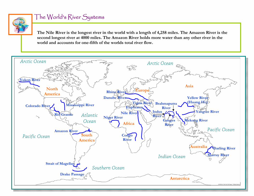
Amazon River
Drake Passage
Strait of Magellan
Darling River
Murray River
Yellow River (Huang He)
Yangtze River Indus River
Ganges River
Brahmaputra River
Mekong River
Tigris River Euphrates
Nile River
Danube River
Niger River
Congo River
Colorado River
Rio Grande
Mississippi River
Yukon River
The World's River Systems
The Nile River is the longest river in the world with a length of 4,258 miles. The Amazon River is the second longest river at 4000 miles. The Amazon River holds more water than any other river in the world and accounts for one-fifth of the worlds total river flow.
Rhine River

10
11
World Seas, Bays & Gulf's
Pacific Ocean
Indian Ocean
Atlantic Ocean
Pacific Ocean
Arctic Ocean Arctic Ocean
Southern Ocean
Africa
Asia
Europe
Australia
Antarctica
South America
North America
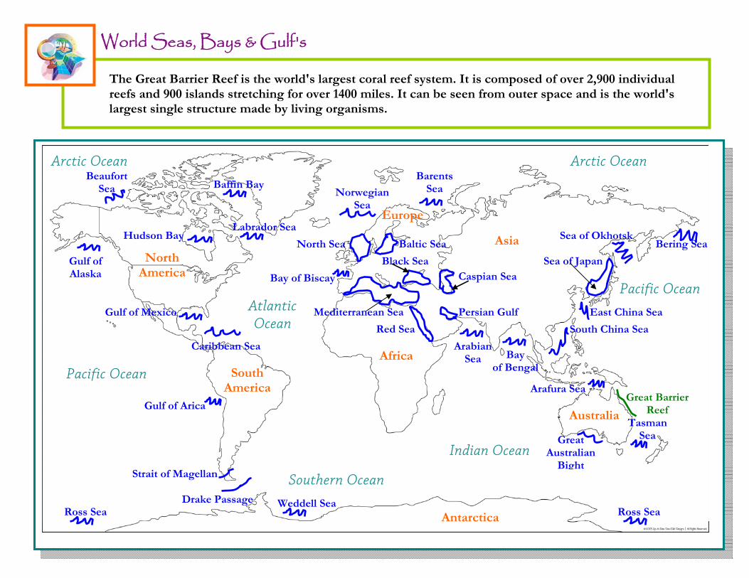
Mediterranean Sea
Red Sea
Persian Gulf
Black Sea Caspian Sea
North Sea Baltic Sea
Norwegian Sea
Barents Sea Baffin Bay
Tasman Sea
Arafura Sea Great Barrier
Reef
Great Australian
Bight
Sea of Japan
East China Sea
Sea of Okhotsk
Arabian Sea Bay
of Bengal
South China Sea
Bering Sea
Bay of Biscay
Gulf of Mexico
Caribbean Sea
Hudson Bay Labrador Sea
Gulf of Alaska
Beaufort Sea
Drake Passage
Strait of Magellan
Gulf of Arica
Ross Sea Ross Sea Weddell Sea
The Great Barrier Reef is the world's largest coral reef system. It is composed of over 2,900 individual reefs and 900 islands stretching for over 1400 miles. It can be seen from outer space and is the world's largest single structure made by living organisms.

12
13
V V
ff
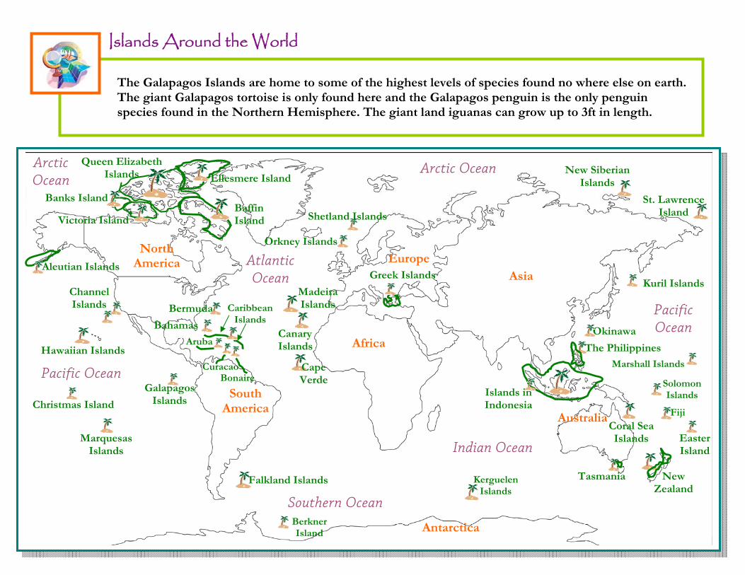
Islands Around the World
Pacific Ocean
Indian Ocean
Atlantic Ocean
Pacific Ocean
Arctic Ocean
Arctic Ocean
Southern Ocean
Europe
Australia
Antarctica
South America
North America
Africa
Asia
Hawaiian Islands
New
Zealand
Solomon Islands
Marshall Islands
Coral Sea Islands
Easter Island
Tasmania
The Philippines
Islands in Indonesia
Okinawa
St. Lawrence Island
Kuril Islands
Canary Islands
Madeira Islands
Cape Verde
Greek Islands
Orkney Islands
Shetland Islands
Falkland Islands
Aruba
Curacao Bonaire
Bahamas
Caribbean Islands
Bermuda
Channel Islands
Aleutian Islands
Ellesmere Island
Baffin Island Victoria Island
Banks Island
Queen Elizabeth Islands
New Siberian Islands
Fiji
Berkner Island
Kerguelen Islands
Galapagos Islands
Christmas Island
Marquesas
Islands
The Galapagos Islands are home to some of the highest levels of species found no where else on earth. The giant Galapagos tortoise is only found here and the Galapagos penguin is the only penguin species found in the Northern Hemisphere. The giant land iguanas can grow up to 3ft in length.

14
15
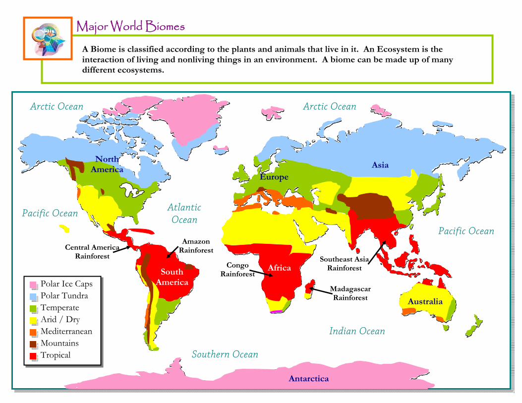
Major World Biomes
Pacific Ocean
Indian Ocean
Atlantic Ocean
Pacific Ocean
Arctic Ocean Arctic Ocean
Southern Ocean
Antarctica
Africa
Asia
Amazon Rainforest
North America
Australia
Africa
Asia Europe
Antarctica
Polar Ice Caps Polar Tundra Temperate Arid / Dry Mediterranean Mountains Tropical
South America
Congo Rainforest
Madagascar Rainforest
Southeast Asia Rainforest
Central America Rainforest
A Biome is classified according to the plants and animals that live in it. An Ecosystem is the interaction of living and nonliving things in an environment. A biome can be made up of many different ecosystems.
16
17
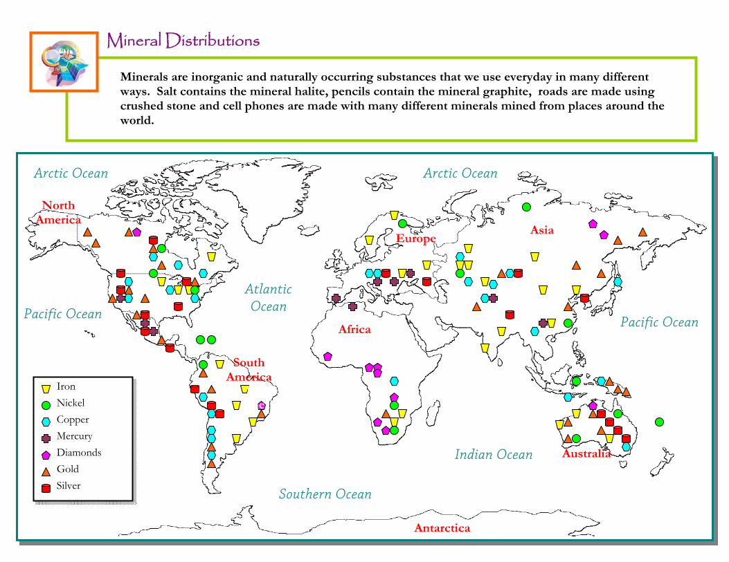
Mineral Distributions
Iron
Nickel
Copper
Mercury
Diamonds
Gold
Silver
Pacific Ocean
Indian Ocean
Atlantic OceanPacific Ocean
Arctic Ocean
Southern Ocean
North America
Australia
Asia Europe
Antarctica
South America
South America
Africa
Arctic Ocean
Minerals are inorganic and naturally occurring substances that we use everyday in many different ways. Salt contains the mineral halite, pencils contain the mineral graphite, roads are made using crushed stone and cell phones are made with many different minerals mined from places around the world.

18

19
Hurricanes & Tornadoes
Cyclones October - November
Typhoons May - December
(The strongest area of all ocean storms)
Hurricanes August - October
Hurricanes June - October
Cyclones December - March
Tornado Alley
Cyclones January - March
Areas where Tornadoes can form
Areas where Hurricanes can form
Arrows show the direction of the storms. The months are when they
occur.
Pacific Ocean
Indian Ocean
Atlantic Ocean
Pacific Ocean
Arctic Ocean
Southern Ocean
North America
Australia
Asia Europe
Antarctica
South America
South America
Arctic Ocean
Africa
The United States has the most tornadoes of any country, as well as the strongest and most violent tornadoes. The United States averaged 1,274 tornadoes per year in the last decade with most of those occurring in Tornado Alley.
20
Areas where Tornadoes can form
Areas where Hurricanes can form
Arrows show the direction of the storms. The months are when they
occur.
21
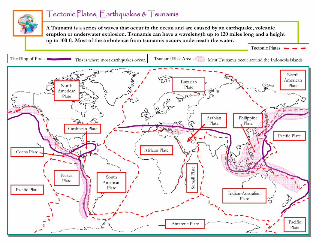
Tectonic Plates, Earthquakes & Tsunamis A Tsunami is a series of waves that occur in the ocean and are caused by an earthquake, volcanic
eruption or underwater explosion. Tsunamis can have a wavelength up to 120 miles long and a height up to 100 ft. Most of the turbulence from tsunamis occurs underneath the water.
Pacific Plate
Pacific Plate
African Plate
Arabian Plate
Nazca Plate
Philippine Plate
Indian-Australian Plate
Antarctic Plate
South American
Plate
North American
Plate
Cocos Plate
Caribbean Plate
Som
ali P
late
Eurasian Plate
North American
Plate
Pacific Plate
The Ring of Fire - This is where most earthquakes occur. Tsunami Risk Area - Most Tsunamis occur around the Indonesia islands.
Tectonic Plates
22
The Ring of Fire - Tsunami Risk Area -
Tectonic Plates -
23
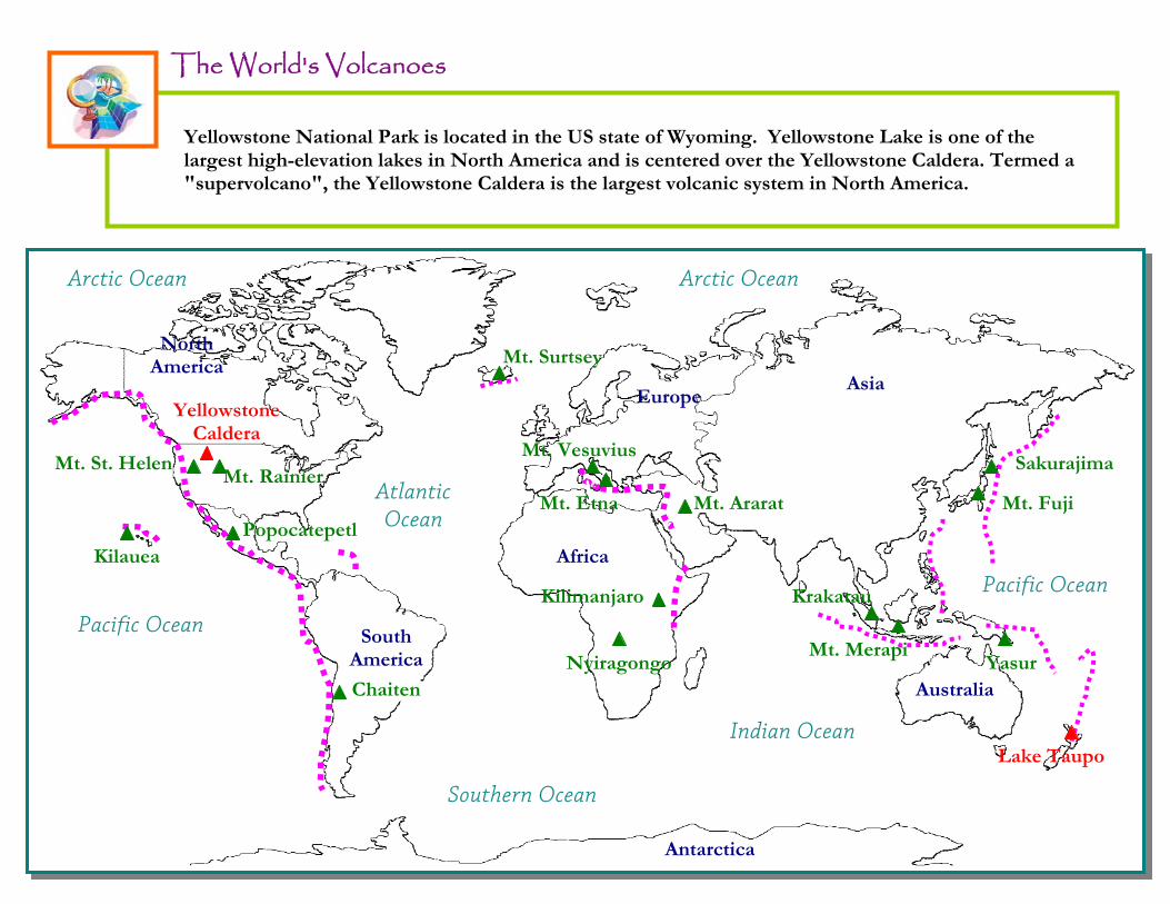
The World's Volcanoes
Pacific Ocean
Indian Ocean
Atlantic Ocean
Pacific Ocean
Arctic Ocean
Southern Ocean
North America
Australia
Asia Europe
Antarctica
South America
South America
Arctic Ocean
Africa
Yellowstone Caldera
Mt. Vesuvius
Popocatepetl
Sakurajima
Kilauea
Lake Taupo
Mt. Etna Mt. Fuji
Chaiten
Mt. Merapi Nyiragongo
Mt. Rainier Mt. St. Helen
Mt. Ararat
Kilimanjaro Krakatau
Mt. Surtsey
Yasur
Yellowstone National Park is located in the US state of Wyoming. Yellowstone Lake is one of the largest high-elevation lakes in North America and is centered over the Yellowstone Caldera. Termed a "supervolcano", the Yellowstone Caldera is the largest volcanic system in North America.
24

25
Reference Map
Pacific Ocean
Indian Ocean
Atlantic Ocean
Pacific Ocean
Arctic Ocean
Southern Ocean
North America
Australia
Asia Europe
Antarctica
South America
Arctic Ocean
Africa