Embed Size (px)
Citation preview
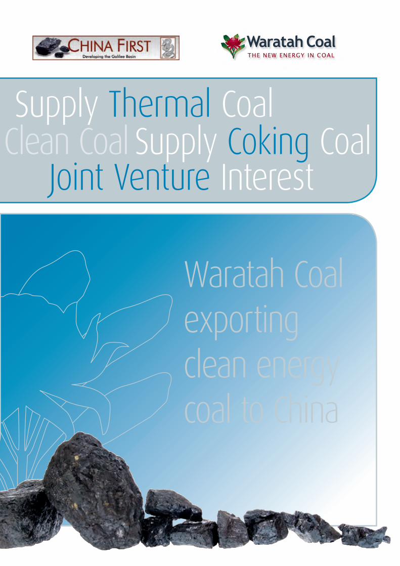
Supply Thermal CoalWorld Class Coal AssetsSupply Coking CoalTo Power the Globe with Clean Coal
Joint Venture InterestDeveloping Infrastructure
Waratah Coal exporting clean energy coal to China
Signing Ceremony of the China First Coal Development Cooperation Agreement held at Parliament House in Canberra, Australia on 21 June 2010. Group Photo (from left to right): Mr Yuan Xingyong, Assistant President of the Export-Import Bank of China; Madame Li Xiaolin, Chairperson of China Power International Holding Ltd; Mr Xi Jinping, Vice President (President Elect) of the People’s Republic of China; The Honourable Kevin Rudd, Prime Minister of Australia at the time; Mr Shen Heting, President of Metallurgical Corporation of China Ltd; Mr Domenic Martino, Director of Waratah Coal Pty Ltd.
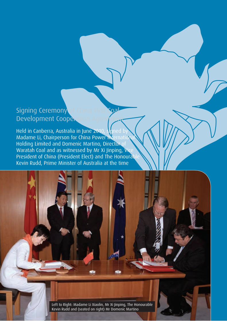
Signing Ceremony of China First Coal Development Cooperation Agreement
Held in Canberra, Australia in June 2010, signed by Madame Li, Chairperson for China Power International Holding Limited and Domenic Martino, Director of Waratah Coal and as witnessed by Mr Xi Jinping, Vice President of China (President Elect) and The Honourable Kevin Rudd, Prime Minister of Australia at the time
Left to Right: Madame Li Xiaolin, Mr Xi Jinping, The Honourable Kevin Rudd and (seated on right) Mr Domenic Martino
Contact Details
BEIJING OFFICE: Waratah Coal Pty Ltd
Physical Address: Room 401 Building 13 YanJingJiaYuan Beijing Economic-Technological Development Area China 100176
Phone: +86 10 8498 2099
Fax: +86 10 8498 2099
Email: [email protected]
Web: www.waratahcoal.com
Contact: Mr Yi Ning Beijing Manager Waratah Coal Pty Ltd
Mobile: +86 135 2042 4158
Email: [email protected]
HONG KONG OFFICE: Waratah Coal Pty Ltd
Physical Address: Level 19 Two International Finance Centre 8 Finance Street Central Hong Kong China
Phone: +852 3101 7055
Fax: +852 2251 1818
BRISBANE OFFICE: Waratah Coal Pty Ltd
Physical Address: Mineralogy House Level 7, 380 Queen Street Brisbane QLD 4000, Australia
Postal Address: GPO Box 1538 Brisbane QLD 4001, Australia
Phone: +61 7 3233 0800
Fax: +61 7 3221 8870
Contact: Mr Keith Zhong Manager Procurements & Logistics Waratah Coal Pty Ltd
Phone: +61 7 3233 0800
Email: [email protected]

Metallurgical Corporation of China
China Railway Group
China Communications Construction
Sino-coal International
China Eximbank
China Power
Professor Clive Palmer with Li Ruogu – Exim Bank President and Chairman
Waratah Coal’s Chinese PartnershipsWaratah Coal’s parent company Mineralogy Pty Ltd (Mineralogy) has been operating within the exploration, mining and infrastructure sector for the past 25 years. This period has seen Mineralogy build strategic alliances with the major resource and infrastructure companies from the People’s Republic of China.
Major Chinese companies such as Metallurgical China Corporation, Sino-coal International, China Railway Group and China Communication Construction Company have signed statements of intent with Waratah Coal to design, develop and operate mines and strategic infrastructure within Australia.
Project finance procured through Eximbank to provide debt funding for Waratah Coal’s projects have been secured. Statements of intent have been signed between Eximbank and Waratah Coal.
Coal off take agreement of 20Mtpa over 21 years have been signed between Waratah Coal and China Power International.
Beijing Coaltrans Conference | 1
ContentsWaratah Coal’s Chinese Partnerships 1
Our Vision 3
Our Business 3
Our History 5
Our Projects 6
Galilee Basin Projects 7
China First Coal Project – Galilee Basin 12
Alpha North Coal Project – Galilee Basin 16
Styx Coal Project – Styx Basin 20
Blackwater EPC 1186 – Bowen Basin 24
Capella EPC 1183 – Bowen Basin 25
Fairlight EPC 1058 – Laura Basin 26
Cooktown EPC 1059 – Laura Basin 27
Strathpine EPC 1015 – Surat Basin 28
Kolan River EPC 1268 – Maryborough Basin 29
Our Consultants 30
Our Team 32
Our Future 36
Contact Directory Inside Back Cover
2 | Beijing Coaltrans Conference

Beijing Coaltrans Conference | 3
Our Vision• To power the globe with clean coal
• Empower our people to achieve the extraordinary
• Ensure zero harm to our people and the environment.
Professor Clive Palmer
Our BusinessWaratah Coal commenced operations in 2001 as an Australian based explorer, exploring for coal in central Queensland, Australia.
Waratah Coal is part of the Mineralogy Group and the company is 100 per cent owned by Mineralogy Pty Ltd. The Mineralogy Group and associated entities have 25 years’ experience developing, managing, and funding a range of major projects. Mineralogy Group has a current market capitalisation of approximately A$11 billion.
The Group currently employs around 2,200 Queenslanders in its activities in the state. Through its diversified interests (which includes the A$6 billion Yabulu Nickel refinery in Townsville, oil and gas exploration in Papua New Guinea and
the A$5 billion Sino Iron iron ore development in Western Australia) the Group has formed major international alliances in China and domestically.
Waratah Coal intends to explore the world class coal assets under its management and prove up these highly valued coal resources to JORC compliant status. Waratah Coal will add value to its coal resources by designing and developing coal infrastructure and supply chains to deliver coal to the export markets at a cost competitive rate.
By 2015 Waratah Coal will have in operation coal mines producing high quality thermal and coking coals. Thermal coal will be destined for the export power generation markets of China, India, Europe and Japan. While coking coal product is destined for the steel export markets of China and Japan.
Waratah Coal prides itself on its commitment to the economic development of regional Australia through the growth of mineral wealth while operating with an excellent record in the areas of safety, health and the environment.
Professor Clive Palmer
Nui Harris

4 | Beijing Coaltrans Conference
Our HistoryWaratah Coal commenced operating in 2001 as an Australian based explorer listed on the Toronto Stock Exchange.
Prior to being privatised Waratah Coal was previously listed on the Toronto Stock Exchange and Australian Stock Market. Waratah Coal was incorporated into the resource development company Mineralogy Pty Ltd in 2009, owned by Professor Clive Palmer.
Since 2001 Waratah Coal has acquired extensive exploration permits for coal and minerals within the states of Queensland and New South Wales and the Northern Territory. The company now has a total of 79 exploration permits for coal and minerals in the granted and application stages. These tenures combined, cover an area of 59,660km², firmly placing Waratah Coal as one of Australia’s leading exploration and coal developers. In the Galilee Basin, central west Queensland, Waratah Coal alone has an exploration coal target of 465 Billion tonnes (Bt) under tenure. Through attentive exploration and mine planning Waratah Coal has developed JORC resources of 7.253Bt and 1.1Bt of probable coal reserves.
Since 2009 Waratah Coal has been developing several thermal and coking coal projects within the state of Queensland. They include the China First Coal Project
and Alpha North Project within the Galilee Basin, central west Queensland and Styx Coal Project, central Queensland, a joint venture project with Queensland Nickel. Combined, these projects require an estimated capital of A$15.0 billion to construct mine, rail and port infrastructure, which when operational will produce 85Mtpa of high quality thermal and coking coal.
Now in 2012 these projects are well advanced with their Environmental Impact Statements, approvals, development plans and securing all important port space. The anticipated coal production commencement date for these projects is Q1 of 2015.
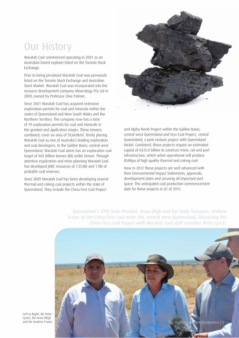
Queensland’s 37th State Premier, Anna Bligh and her State Treasurer, Andrew Fraser at the China First Coal mine site, central west Queensland. Discussing the
China First Coal Project with Waratah Coal staff member Peter Lynch.
Beijing Coaltrans Conference | 5
Left to Right: Mr Peter Lynch, Ms Anna Bligh and Mr Andrew Fraser
6 | Beijing Coaltrans Conference
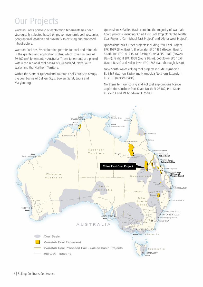
Our ProjectsWaratah Coal’s portfolio of exploration tenements has been strategically selected based on proven economic coal resources, geographical location and proximity to existing and proposed infrastructure.
Waratah Coal has 79 exploration permits for coal and minerals in the granted and application status, which cover an area of 59,660km² Tenements – Australia. These tenements are placed within the regional coal basins of Queensland, New South Wales and the Northern Territory.
Within the state of Queensland Waratah Coal’s projects occupy the coal basins of Galilee, Styx, Bowen, Surat, Laura and Maryborough.
HOBART
MELBOURNE
ADELAIDE
PERTH
SYDNEY
CANBERRA
DARWIN
BRISBANE
Gladstone
Newcastle
Coffs Harbour
Wollongong
Rockhampton
MackayDalrymple Bay
Abbot Point
Wiggins IslandRG Tannah
BowenMt Isa
Normanton
Port Keats
Kunnanurra
Alpha
Miles
Moree
Townsville
RichmondPort Hedland
Cairns
Weipa
Cooktown
Nhulunbuy
Groote Eylandt
Waratah Coal Tenement
Waratah Coal Proposed Rail - Galilee Basin Projects
Railway - Existing
Coal Basin
W e s t e r n
A u s t r a l i a
A U S T R A L I A
Q u e e n s l a n d
V i c t o r i a
T a s m a n i a
A . C . T
N o r t h e r n
T e r r i t o r y
S o u t h
A u s t r a l i a
N e w
S o u t h
W a l e s
China First Coal Project
Queensland’s Galilee Basin contains the majority of Waratah Coal’s projects including ‘China First Coal Project’, ‘Alpha North Coal Project’, ‘Carmichael East Project’ and ‘Alpha West Project’.
Queensland has further projects including Styx Coal Project EPC 1029 (Styx Basin), Blackwater EPC 1186 (Bowen Basin), Strathpine EPC 1015 (Surat Basin), Capella EPC 1183 (Bowen Basin), Fairlight EPC 1058 (Laura Basin), Cooktown EPC 1059 (Laura Basin) and Kolan River EPC 1268 (Maryborough Basin).
New South Wales coking coal projects include Nymboida EL 6467 (Morten Basin) and Nymboida Northern Extension EL 7186 (Morten Basin).
Northern Territory coking and PCI coal explorations licence applications include Port Keats North EL 25482, Port Keats EL 25463 and Mt Goodwin EL 25483.

Galilee Basin Projects
Beijing Coaltrans Conference | 7
LAKE CARGOON
LAKE POWLATHANGA
.
.
.
LAKE NUGA NUGA
.
Lake Barcoorah
Lake Buchanan
Webb Lake
Lake Galilee
Lake Mueller
PALUMA RESERVOIR
ROSS RIVER RESERVOIR
LAKE DALRYMPLE
EUNGELLA RESERVOIR
LAKE KINCHANT
AWOONGA RESERVOIR
CALLIDE RESERVOIR
LAKE MONDURAN
WURUMA RESERVOIR
LENTHALLS RESERVOIR
LAKE MARABOON
FORSAYTH
MAXWELTON RICHMOND
STAMFORD
CORFIELD
WINTON
MORELLA
DILLCAR
STONEHENGE
JUNDAH
WINDORAH
EINASLEIGH
KIDSTON
TREBONNE
UPPER STONE
HALIFAXLUCINDA
CORDELIA
BAMBAROO
INGHAM
ABERGOWRIE
PALM ISLAND ABORIGINAL COMMUNITOOBANNA
PICNIC BAY
MINGELA
NELLY BAY
ROLLINGSTONEPALUMA
PALLARENDA
WOODSTOCK
CLARE
GIRU
RITA ISLAND
BRANDON
GUMLUGUTHALUNGRA
HOME HILL
AYR
PENTLAND
PRAIRIEHUGHENDEN
TORRENS CREEK
CHARTERS TOWERS
BALFES CREEK
HOMESTEAD
RAVENSWOOD
COLLINSVILLE
MERINDA
PROSERPINE
CALEN SEAFORTH
BLOOMSBURY
GOONYELLA
Mount Coolon
GLENDEN
MORANBAH
EUNGELLA (DALRYMPLE HEIGHTS)
BAKERS CREEK
SARINA
HALF TIDE
FINCH HATTON
NEBO
SARINA BEACH
BUCASIA
ETON
HABANA
MIRANI
ILBILBIE
KOUMALA
MARIAN
AramacCLERMONT
Blair Athol
MARLBOROUGH
ST LAWRENCE
MIDDLEMOUNT
ILFRACOMBE
Barcaldine
AlphaJericho
TIERI
FAIRBAIRN DAM
EMERALD
CAPELLA
RUBYVALE
GINDIE
ANAKIE
DINGO
BLUFF
BLACKWATER
DUARINGA
COMET
YARAKA
ISISFORD Blackall
EMMET
TAMBO
SPRINGSURE
ROLLESTONMOURA
WOORABINDA ABORIGINAL COMMUNITBARALABA
ADAVALE
AUGATHELLA
INJUNE
TAROOM
YAAMBATHE CAVES
ROCKHAMPTON
MOUNT LARCOM
MOUNT MORGAN
STANWELL
OLD WESTWOOD
GRACEMERE
GOGANGO
WOWAN
DULULU
BOULDERCOMBE
RAGLANMARMOR
BAJOOL
EMU PARK
YEPPOON
KEPPEL SANDSPARKHURST
TANNUM SANDSCALLIOPE
UBOBOBANANA THANGOOL
BOROREN
MONTO
BILOELA
CALLIDE
THEODORE
GIN GIN
MIRIAM VALE
YANDARAN
BUNDABERGBINGERA
MOORE PARKBURNETT HEADS
ELLIOTT HEADS
AVONDALE
CRACOW
EIDSVOLD
MUNDUBBERA
ABERCORN
GAYNDAH
HERVEY BAY
WOODGATE
BURRUM HEADSCHILDERS
MOUNT PERRY
WALLAVILLE
HOWARD
BIGGENDEN
TIARO
MARYBOROUGH
BAUPLE
TORBANLEA
CARMILA
FAIRYMEAD
OGMORE
ELALIE
WHITEWOOD
BLUEWATER
PORT ALMA
AIRLIE BEACH
DYSART
GREENVALE
MUTTABURRA
EPC1290
EPC1289
EPC1105
EPC1105
EPC1157
EPC1079
EPC1053
EPC1287
EPC1281
EPC1285
EPC1283
EPC1286
EPC1040
EPC1079
EPC1156
EPC1155
EPC1280
EPC1284
EPC1288
G A L I L E E
B A S I N
China First Coal Project
Alpha West Coal Project
Alpha North Coal Project
Carmichael East Coal Project
Waratah Coal
TENEMENTS
50km0
A U S T R A L I A
Overview
Waratah Coal is the largest exploration tenement holder within the Galilee Basin. The tenements comprise 19 contiguous exploration permits for coal being granted or application tenures.
Waratah Coal also holds 7 exploration permits for minerals within the Galilee Basin. The Galilee Basin covers an area of approximately 247,000km² of which Waratah Coal’s coal and mineral tenements account for 16,930km² Tenements – Galilee Basin or just under 7% of the Galilee Basin.
Waratah Coal’s major projects within the basin are ‘China First Coal Project’, ‘Alpha North Coal Project’, ‘Carmichael East Project’ and ‘Alpha West Project’.

Galilee Basin Regional Geology
The Galilee Basin covers an area estimated at 247,000km² in central west Queensland. This basin is entirely intracratonic and is filled with late carboniferous to middle triassic sediments. These rocks are dominantly fluvial in origin with minor glacial material developed at the base of the succession.
The basin is almost entirely overlain by the jurassic / cretaceous Eromanga Basin. Only along the eastern margin of the Galilee Basin are the permian / triassic rocks exposed in a long, narrow, gently curved belt. The maximum stratigraphic thickness of the basin is found in the Koburra Trough, in the
centre of the basin, where 2,818m of sediments have been penetrated.
The Tertiary comprises unconsolidated to semi-consolidated sediments ranging in thickness from 30m to 125m. The Rewan Formation, consisting of triassic competent claystones and siltstones, is situated unconformably between the overlying Tertiary and the underlying late permian Bandanna Formation.
Within the Galilee Basin coal is present in the early permian Aramac Coal Measures and two units of the late permian sequence of the Galilee Basin; the Bandanna Formation equivalents, and the Colinlea Sandstone, which are the lateral equivalents of the Betts Creek Beds. The Bandanna Formation equivalents and Colinlea Sandstone both out crop along the eastern margin of the Galilee Basin where petrographic analysis show the coals to be subhydrous and of low rank, ranging from bright seams in the south to thick dull seams in the north.
BRISBANE
Gladstone
Rockhampton
Bowen
Townsville
Mt Isa
Source: DERM Queensland
Cairns
Cooktown
Weipa
Mackay
Q U E E N S L A N D
Abbot Point
Dalrymple Bay
Wiggins Island (WICET)RG Tannah
G A L I L E E
S U R A T
C A L L I D E
M U L G I D I E
T A I R O
B L A I RA T H O L
C A L E N
T A R O N G
I P S W I C H
M A R Y B O R O U G H
B U R R U M
S T Y X
L A U R A
O L I V E R I V E R
M O U N T M U L L I G A N
C O O P E R
E R O M A N G A
E R O M A N G A
B O W E N
400km0
8 | Beijing Coaltrans Conference
Galilee Basin Target Resources
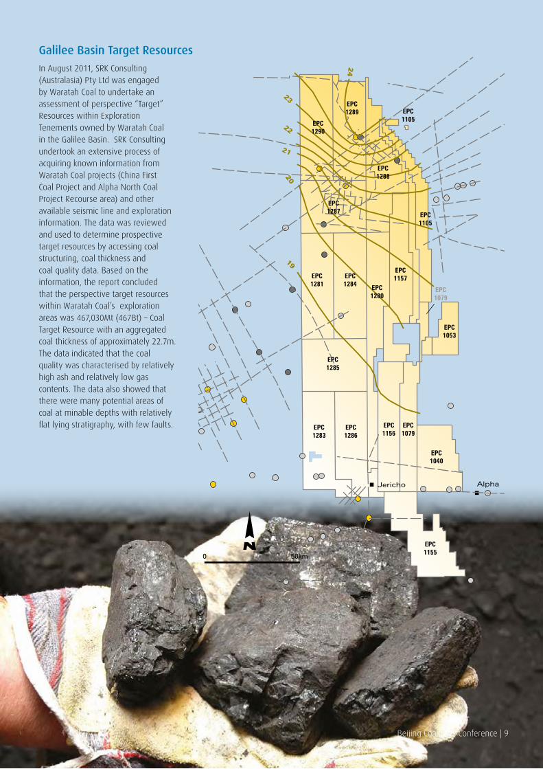
In August 2011, SRK Consulting (Australasia) Pty Ltd was engaged by Waratah Coal to undertake an assessment of perspective “Target” Resources within Exploration Tenements owned by Waratah Coal in the Galilee Basin. SRK Consulting undertook an extensive process of acquiring known information from Waratah Coal projects (China First Coal Project and Alpha North Coal Project Recourse area) and other available seismic line and exploration information. The data was reviewed and used to determine prospective target resources by accessing coal structuring, coal thickness and coal quality data. Based on the information, the report concluded that the perspective target resources within Waratah Coal’s exploration areas was 467,030Mt (467Bt) – Coal Target Resource with an aggregated coal thickness of approximately 22.7m. The data indicated that the coal quality was characterised by relatively high ash and relatively low gas contents. The data also showed that there were many potential areas of coal at minable depths with relatively flat lying stratigraphy, with few faults.
AlphaJericho
50km0
EPC1290
EPC1289 EPC
1105
EPC1105
EPC1157
EPC1079
EPC1053
EPC1287
EPC1281
EPC1285
EPC1283
EPC1286
EPC1040
EPC1079
EPC1156
EPC1155
EPC1280
EPC1284
EPC1288
24
23
22
21
2019
Beijing Coaltrans Conference | 9
10 | Beijing Coaltrans Conference
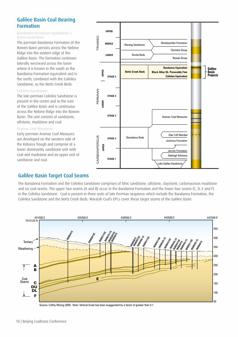
Galilee Basin Coal Bearing FormationBandanna Formation Equivalents / Betts Creek Beds:
The permian Bandanna Formation of the Bowen Basin persists across the Nebine Ridge into the eastern edge of the Galilee Basin. The formation continues laterally westward across the basin where it is known in the south as the Bandanna Formation equivalent and in the north, combined with the Colinlea Sandstone, as the Betts Creek Beds.
Colinlea Sandstone:
The late permian Colinlea Sandstone is present in the centre and to the east of the Galilee Basin and is continuous across the Nebine Ridge into the Bowen Basin. The unit consists of sandstone, siltstone, mudstone and coal.
Aramac Coal Measures:
Early permian Aramac Coal Measures are developed on the western side of the Koburra Trough and comprise of a lower dominantly sandstone unit with coal and mudstone and an upper unit of sandstone and coal.
Moolayember Formation
Clematis Group
Rewan Group
Bandanna Equivalent
Black Alley Sh. Peawaddy FmnColinlea Equivalent
Aramac Coal Measures
Edie Tuff Member
GalileeBasinProjects
Jochmus FormationBoonderoo Beds
Jericho Formation
Oakleigh Siltstone
Lake Galilee Sandstone
Dunda Beds
Betts Creek Beds
Warang Sandstone
TR
IAS
SIC
UPPER
MIDDLE
LOWER
STAGE 4
STAGE 5
STAGE 3
STAGE 2
STAGE 1
LOW
ERU
PPER
UPP
ER
PER
MIA
NC
AR
BO
NIF
ER
OU
S
Galilee Basin Target Coal Seams
The Bandanna Formation and the Colinlea Sandstone comprises of lithic sandstone, siltstone, claystone, carbonaceous mudstone and six coal seams. The upper two seams (A and B) occur in the Bandanna Formation and the lower four seams (C, D, E and F) in the Colinlea Sandstone. Coal is present in three units of late Permian sequence which include the Bandanna Formation, the Colinlea Sandstone and the Betts Creek Beds. Waratah Coal’s EPCs cover these target seams of the Galilee Basin.
WAR
3415
WAR
3615
C
WAR
3715
CW
AR37
5-15
WAR
3815
CW
AR38
15
WAR
4015
WAR
4015
CW
AR40
5-15
WAR
4115
C
WAR
4215
RW
AR42
5-15
WAR
4315
CW
AR43
5-15
WAR
4415
CW
AR44
15W
AR44
5-15
WAR
45-1
5CW
AR45
5-15
WAR
4615
435500 E 439500 E 443500 E 447500 E431500 E7415125 N
Tertiary
Weathering
CoalSeams
300
400
350
450
250AB
CDUDL
E
F
200
150
100
50Source: Coffey Mining 2009. Note: Vertical Scale has been exaggerated by a factor of greater than 5:1.

Beijing Coaltrans Conference | 11
Metallurgical Corporation of China
China Railway Group
China Communication Construction Company
Sino-coal International China’s Eximbank
China Power International
China’s state-owned enterprises & Waratah Coal exporting clean energy coal to China
12 | Beijing Coaltrans Conference
COKING COAL PROJECTOverview
The China First Coal Project is an integrated project to develop a new coal mine, high capacity rail system and coal export facilities to export high volatile low sulphur steaming coal to international markets.
The coal will be sourced from EPC 1040 and EPC 1079 near the township of Alpha in the Galilee Basin, 160km west of Emerald.
The annual run of mine (ROM) coal production will be 56Mtpa to produce 40Mtpa of saleable export product coal.
The coal will be transported by a heavy haul standard gauge rail system to the North Queensland Port of Abbot Point ready for export.
To date China First Coal Project has proven up 1.1Bt of coal reserves and 3.68Bt of coal resources, JORC code compliant.
The project elements include:
• Coal mining from both open-cut and underground longwall sources
• Coal handling and preparation
• Heavy haul standard gauge rail transportation
• Coal port export facilities
• Associated project infrastructure.
Exploration
The proposed mine is situated in EPC 1040 and EPC 1079, north-west of Alpha.
Exploration to date has identified sufficient resources to develop a 56Mtpa ROM tonne mine with a mine life of 25 years.
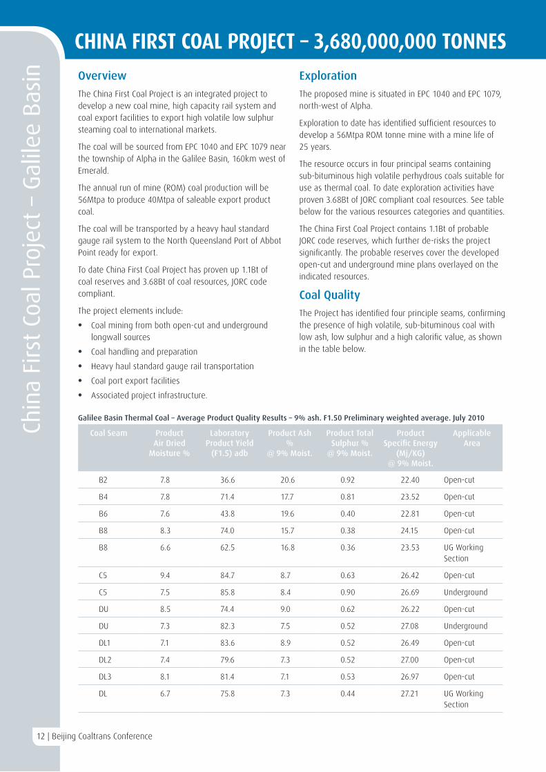
The resource occurs in four principal seams containing sub-bituminous high volatile perhydrous coals suitable for use as thermal coal. To date exploration activities have proven 3.68Bt of JORC compliant coal resources. See table below for the various resources categories and quantities.
The China First Coal Project contains 1.1Bt of probable JORC code reserves, which further de-risks the project significantly. The probable reserves cover the developed open-cut and underground mine plans overlayed on the indicated resources.
Coal Quality
The Project has identified four principle seams, confirming the presence of high volatile, sub-bituminous coal with low ash, low sulphur and a high calorific value, as shown in the table below.
Chin
a Fi
rst
Coal
Pro
ject
– G
alile
e B
asin
12 | Beijing Coaltrans Conference
Coal Seam Product Air Dried
Moisture %
Laboratory Product Yield
(F1.5) adb
Product Ash %
@ 9% Moist.
Product Total Sulphur %
@ 9% Moist.
Product Specific Energy
(Mj/KG) @ 9% Moist.
Applicable Area
B2 7.8 36.6 20.6 0.92 22.40 Open-cut
B4 7.8 71.4 17.7 0.81 23.52 Open-cut
B6 7.6 43.8 19.6 0.40 22.81 Open-cut
B8 8.3 74.0 15.7 0.38 24.15 Open-cut
B8 6.6 62.5 16.8 0.36 23.53 UG Working Section
C5 9.4 84.7 8.7 0.63 26.42 Open-cut
C5 7.5 85.8 8.4 0.90 26.69 Underground
DU 8.5 74.4 9.0 0.62 26.22 Open-cut
DU 7.3 82.3 7.5 0.52 27.08 Underground
DL1 7.1 83.6 8.9 0.52 26.49 Open-cut
DL2 7.4 79.6 7.3 0.52 27.00 Open-cut
DL3 8.1 81.4 7.1 0.53 26.97 Open-cut
DL 6.7 75.8 7.3 0.44 27.21 UG Working Section
Galilee Basin Thermal Coal – Average Product Quality Results – 9% ash. F1.50 Preliminary weighted average. July 2010
CHINA FIRST COAL PROJECT – 3,680,000,000 TONNES
Mining
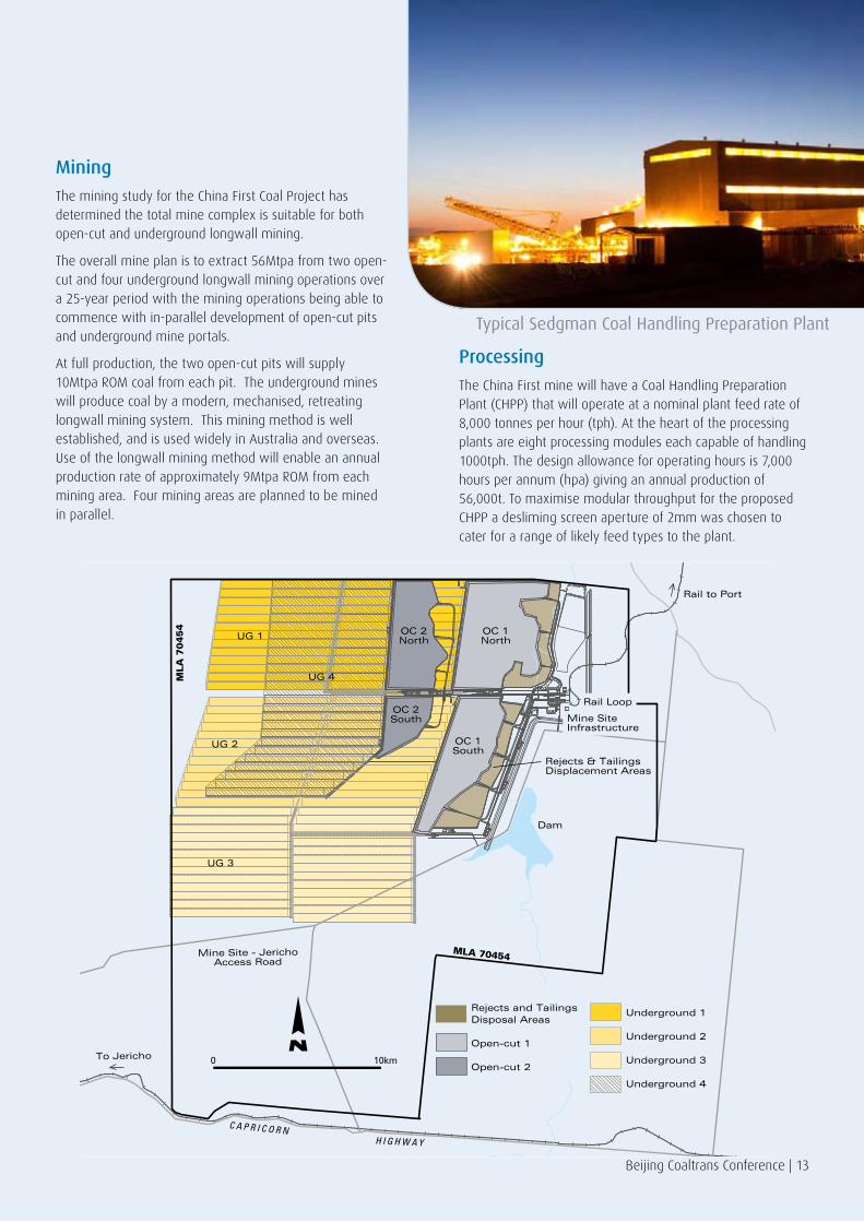
The mining study for the China First Coal Project has determined the total mine complex is suitable for both open-cut and underground longwall mining.
The overall mine plan is to extract 56Mtpa from two open-cut and four underground longwall mining operations over a 25-year period with the mining operations being able to commence with in-parallel development of open-cut pits and underground mine portals.
At full production, the two open-cut pits will supply 10Mtpa ROM coal from each pit. The underground mines will produce coal by a modern, mechanised, retreating longwall mining system. This mining method is well established, and is used widely in Australia and overseas. Use of the longwall mining method will enable an annual production rate of approximately 9Mtpa ROM from each mining area. Four mining areas are planned to be mined in parallel.
Processing
The China First mine will have a Coal Handling Preparation Plant (CHPP) that will operate at a nominal plant feed rate of 8,000 tonnes per hour (tph). At the heart of the processing plants are eight processing modules each capable of handling 1000tph. The design allowance for operating hours is 7,000 hours per annum (hpa) giving an annual production of 56,000t. To maximise modular throughput for the proposed CHPP a desliming screen aperture of 2mm was chosen to cater for a range of likely feed types to the plant.
Mine Site - JerichoAccess Road
To Jericho
C A P R I C O R NH I G H W A Y
MLA 70454
MLA
70454 OC 1
NorthOC 2NorthUG 1
UG 2
UG 4
UG 3
OC 1South
OC 2South
Rail to Port
Underground 1
Underground 2
Underground 3
Underground 4
Rejects and TailingsDisposal Areas
Open-cut 1
Open-cut 2
Rail Loop
Rejects & TailingsDisplacement Areas
Dam
Mine SiteInfrastructure
10km0
Beijing Coaltrans Conference | 13
Typical Sedgman Coal Handling Preparation Plant
Rail
Waratah Coal will transport processed coal using a new railway system approximately 471km in length that will run from the Galilee Basin to the existing Port of Abbot Point. The rail project includes a state of the art, heavy haul, standard gauge
Townsville
Abbot Point
Alpha NorthCoal Project
Carmichael EastCoal Project
Alpha WestCoal Project
0 100km
Bowen
Mackay
Rockhampton
Gladstone
Middlemount
Blackwater
Blair Athol
Capella
Emerald
Alpha
Moranbah
Collinsville
Charters Towers
40 Mtpa 2 Berth Coal Loading Terminal
471km Standard Gauge Heavy Haul Rail
China First Coal Project
G A L I L E E
B A S I N
B O W E N
B A S I N
S T Y X
B A S I N
Dalrymple Bay
Wiggins Island (WICET)RG Tannah
A U S T R A L I A
14 | Beijing Coaltrans Conference
railway to support 20,000t payload train units. The rail project is currently being designed to support a 60Mtpa payload with planning works being undertaken to support up to 400Mtpa.
The current design allows for the following basic modifications to be made to the base case project design to facilitate increase capacity.
• Single line with up to 6 passing loops = 40Mtpa;
• Single line with up to 9 passing loops = 60Mtpa;
• Single line with up to 12 passing loops = 80-120Mtpa; and
• Single line with up to 16 passing loops with incremental duplicated sections between passing loops up to full duplication = 120-400Mtpa.
The flexibility in the current rail project design enables the Waratah Coal rail project to enable other third-parties to utilise the rail infrastructure with minor infrastructure upgrades providing for significant increases in capacity.
Standing behind signing table from
Left to Right: Madame Yu Wen –
Deputy Division Chief, Buyer Credit
Division II, Corporate Business
Department II of the Export-Import
Bank of China; Madame Zou Hongying
– Vice CFO of Metallurgical Corporation
of China Ltd; Mr Li Shiyu – CFO of
Metallurgical Corporation of China Ltd;
Mr Zhang Yujing – President of China
Chamber of Commerce for Import
& Export of Machinery & Electronic
Products; Mr Shen Heting – President
of Metallurgical Corporation of China
Ltd; Madame Li Xiaolin – Chairperson
of China Power International Holding
Ltd; Mr Li Jichen – General Manager,
Corporate Business Department II of
the Export-Import Bank of China; Mr Li
Changjin – President of China Railway
Group Ltd; Mr Chen Yusheng – Vice
President of China Communications
Construction Company; Mr Liang
Jun – Chairman of Ambitious Treasure
Global Ltd, Singapore; Mr Zheng Youyi
– President of ChinaCoal International
Engineering Design & Engineering
Institute.
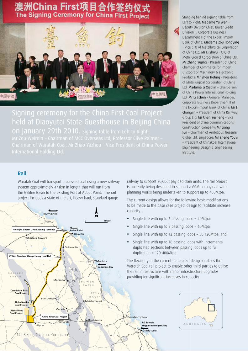
Signing ceremony for the China First Coal Project held at Diaoyutai State Guesthouse in Beijing China on January 29th 2010. Signing table from Left to Right: Mr Zou Weimin – Chairman of MCC Overseas Ltd; Professor Clive Palmer – Chairman of Waratah Coal; Mr Zhao Yazhou – Vice President of China Power International Holding Ltd.
Eight BerthStand Alone Jetty
Stand Alone JettyCoal Stockyards
Stand Alone JettyRail Loops
Abbot Point State Development Area
T4-T9Rail
Loop
T4-T9 Stockyard
Great Barrier Reef Marine Park
ExistingAbbot Point'T1' Terminal
NorthBruce
CoastHighw
ayRailw
ay
Waratah Proposed Stand Alone Jetty Development
Proposed Development - Others
0 4km
Beijing Coaltrans Conference | 15
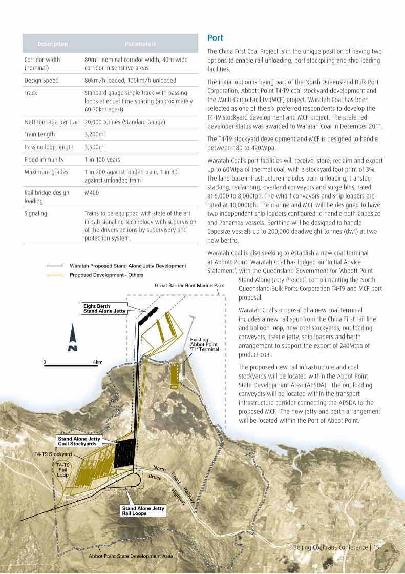
Description Parameters
Corridor width (nominal)
80m – nominal corridor width, 40m wide corridor in sensitive areas
Design Speed 80km/h loaded, 100km/h unloaded
Track Standard gauge single track with passing loops at equal time spacing (approximately 60-70km apart)
Nett tonnage per train 20,000 tonnes (Standard Gauge)
Train Length 3,200m
Passing loop length 3,500m
Flood immunity 1 in 100 years
Maximum grades 1 in 200 against loaded train, 1 in 80 against unloaded train
Rail bridge design loading
M400
Signaling Trains to be equipped with state of the art in-cab signaling technology with supervision of the drivers actions by supervisory and protection system.
Port
The China First Coal Project is in the unique position of having two options to enable rail unloading, port stockpiling and ship loading facilities.
The initial option is being part of the North Queensland Bulk Port Corporation, Abbott Point T4-T9 coal stockyard development and the Multi-Cargo Facility (MCF) project. Waratah Coal has been selected as one of the six preferred respondents to develop the T4-T9 stockyard development and MCF project. The preferred developer status was awarded to Waratah Coal in December 2011.
The T4-T9 stockyard development and MCF is designed to handle between 180 to 420Mtpa.
Waratah Coal’s port facilities will receive, store, reclaim and export up to 60Mtpa of thermal coal, with a stockyard foot print of 3%. The land base infrastructure includes train unloading, transfer, stacking, reclaiming, overland conveyors and surge bins, rated at 6,000 to 8,000tph. The wharf conveyors and ship loaders are rated at 10,000tph. The marine and MCF will be designed to have two independent ship loaders configured to handle both Capesize and Panamax vessels. Berthing will be designed to handle Capesize vessels up to 200,000 deadweight tonnes (dwt) at two new berths.
Waratah Coal is also seeking to establish a new coal terminal at Abbott Point. Waratah Coal has lodged an ‘Initial Advice Statement’, with the Queensland Government for ‘Abbott Point
Stand Alone Jetty Project’, complimenting the North Queensland Bulk Ports Corporation T4-T9 and MCF port proposal.
Waratah Coal’s proposal of a new coal terminal includes a new rail spur from the China First rail line and balloon loop, new coal stockyards, out loading conveyors, trestle jetty, ship loaders and berth arrangement to support the export of 240Mtpa of product coal.
The proposed new rail infrastructure and coal stockyards will be located within the Abbot Point State Development Area (APSDA). The out loading conveyors will be located within the transport infrastructure corridor connecting the APSDA to the proposed MCF. The new jetty and berth arrangement will be located within the Port of Abbot Point.

0 10km
EPC 1053EPC 1079
EPC 1156 EPC 1079
UG 1
UG 3
UG 4
UG 2
OC 1
OC 1
OC2
Underground 1
Underground 2
Underground 3
Underground 4
Open-cut 1
Open-cut 2
Alpha West Mine Site
Future Railto Port
RailLoop
Mining
Preliminary mining studies for the Alpha North Coal Project has determined the total mine complex is suitable for both open-cut and underground longwall mining.
The overall mine plan is to extract 56Mtpa from two open-cut and four underground longwall mining operations over a 25-year period with the mining operations being able to commence with in-parallel development of open-cut pits and underground mine operations.
At full production, the two open-cut pits will supply 10Mtpa ROM coal from each pit. The underground mines will produce coal by a modern, mechanised, retreating longwall mining system. This mining method is well established, and is used widely in Australia and overseas. Use of the longwall mining method will enable an annual production rate of approximately 9Mtpa ROM from each mining area. Four mining areas are planned to be mined in parallel.
Processing
The Alpha North Coal Project will have a CHPP that will blend and wash ROM coal. With a yield of 70% the expected product coal specification will have an energy ranking of 6000 kcal/kg (adb). The plant setup will be similar to technology being proposed for the China First Coal model with eight modules each processing 1000tph.
Rail
The Alpha North rail spur will tie to the proposed China First rail system transporting coal to the port site of Abbott Point from the Galilee Basin.
Like the proposed Galilee Basin rail system Alpha North will run the latest rail technology, heavy haul standard gauge system able to handle 20,000t train consists.
Approximately 6 to 7 trains will depart the mine on a daily basis to transport 40Mt of product coal per annum.
Port
Alpha North Coal Project will have port capacity to support 40Mtpa of product coal within the port precinct of the China First port area. The China First port precinct will be developing a 240Mtpa port allowing third-party users access to spare capacity.
The port site will have port facilities to receive, store, reclaim and export up to 240Mtpa of product coal.
Alpha North Coal project will be part of the China First development of new coal stockyards, out loading conveyors, trestle jetty, ship loaders and berth arrangement to support the export of 240Mtpa of product coal.
Beijing Coaltrans Conference | 17
PROJECT AVAILABLE FOR JOINT VENTURE

18 | Beijing Coaltrans Conference
COKING COAL PROJECTSt
yx C
oal P
roje
ct –
Sty
x B
asin Overview
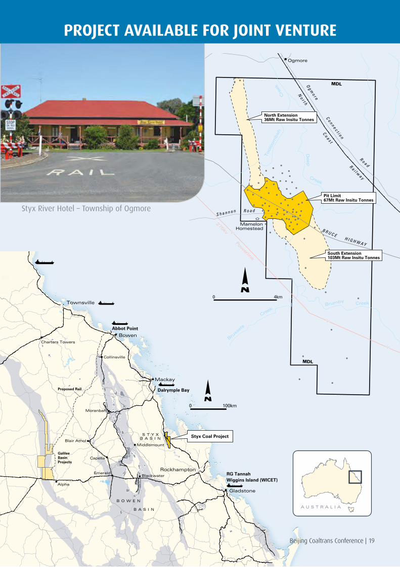
The Styx Coal Project is seeking to develop an integrated coal project of new coal mine, rail connection and connection to existing coal port facilities. The coal will be sourced from EPC 1029, located north of Marlborough Township in the Styx Basin, 160km north of Rockhampton.
The Styx Coal Project will produce semi-soft coking coal through two open-cut operations with a ROM annual output of 2Mtpa ramping up to 6.5Mtpa within four years of project commencement.
Coal will be transported utilising the existing rail infrastructure ‘North Coast Line’, which traverses through the Project’s EPC 1029. The coal will then be able to be delivered to the port sites of Dalrymple Bay, Abbott Point, Townsville and Wiggins Island Coal Export Terminal (WICET).
The Styx Coal Project is well advanced with mine design, processing analysis and environmental approvals. Late in 2010 management commenced design and environmental studies and now expect to be in production as early as 2013.
The project elements include:
• Proven JORC Coal Resources of 232.2Mt of coal
• Coal mining open-cut operations
• Coal handling and preparation
• Narrow gauge rail spur and connection to North Coast Line
• Connection to existing port facilities
• Associated project infrastructure.
Exploration
The Styx Coal Project area lies within EPC 1029, part of the Styx Basin.
The Styx Basin covers an area of approximately 300km² onshore and 500km² offshore, under water depths of 100m. The basin is located approximately 120km north of the major regional city of Rockhampton and 170km south of the international export port facility of Dalrymple Bay.
The known coal bearing strata of the basin are referred to as the Styx Coal Measures and consist of quartzose, calcareous, lithic and pebble stones, pebbly conglomerate, siltstone, carbonaceous shale and coal. The environment of deposition was freshwater, deltaic to paludal with occasional marine incursions.
The coal seams are relatively shallow with average cumulative thickness of the full sequence of coal of approximately 6m.
The coal seams dip generally to the east with the Violet seam, the lowest coal seam in the sequence sub cropping in the west of EPC 1029.
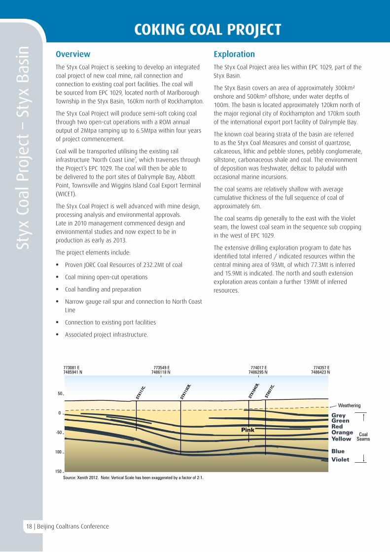
The extensive drilling exploration program to date has identified total inferred / indicated resources within the central mining area of 93Mt, of which 77.3Mt is inferred and 15.9Mt is indicated. The north and south extension exploration areas contain a further 139Mt of inferred resources.
773081 E7485941 N
774357 E7486423 N
-100
0
773549 E7486118 N
774017 E7486295 N
50
-50
-150
STX1
17C,
STX0
77C,
STX1
04CR
,
STX1
13CR
,
Weathering
GreyGreenRedPink OrangeYellow
BlueViolet
Source: Xenith 2012. Note: Vertical Scale has been exaggerated by a factor of 2:1.
CoalSeams
COKING COAL PROJECT
18 | Beijing Coaltrans Conference
COKING COAL PROJECTSt
yx C
oal P
roje
ct –
Sty
x B
asin Overview
The Styx Coal Project is seeking to develop an integrated coal project of new coal mine, rail connection and connection to existing coal port facilities. The coal will be sourced from EPC 1029, located north of Marlborough Township in the Styx Basin, 160km north of Rockhampton.
The Styx Coal Project will produce semi-soft coking coal through two open-cut operations with a ROM annual output of 2Mtpa ramping up to 6.5Mtpa within four years of project commencement.
Coal will be transported utilising the existing rail infrastructure ‘North Coast Line’, which traverses through the Project’s EPC 1029. The coal will then be able to be delivered to the port sites of Dalrymple Bay, Abbott Point, Townsville and Wiggins Island Coal Export Terminal (WICET).
The Styx Coal Project is well advanced with mine design, processing analysis and environmental approvals. Late in 2010 management commenced design and environmental studies and now expect to be in production as early as 2013.
The project elements include:
• Proven JORC Coal Resources of 232.2Mt of coal
• Coal mining open-cut operations
• Coal handling and preparation
• Narrow gauge rail spur and connection to North Coast Line
• Connection to existing port facilities
• Associated project infrastructure.
Exploration
The Styx Coal Project area lies within EPC 1029, part of the Styx Basin.
The Styx Basin covers an area of approximately 300km² onshore and 500km² offshore, under water depths of 100m. The basin is located approximately 120km north of the major regional city of Rockhampton and 170km south of the international export port facility of Dalrymple Bay.
The known coal bearing strata of the basin are referred to as the Styx Coal Measures and consist of quartzose, calcareous, lithic and pebble stones, pebbly conglomerate, siltstone, carbonaceous shale and coal. The environment of deposition was freshwater, deltaic to paludal with occasional marine incursions.
The coal seams are relatively shallow with average cumulative thickness of the full sequence of coal of approximately 6m.
The coal seams dip generally to the east with the Violet seam, the lowest coal seam in the sequence sub cropping in the west of EPC 1029.
The extensive drilling exploration program to date has identified total inferred / indicated resources within the central mining area of 93Mt, of which 77.3Mt is inferred and 15.9Mt is indicated. The north and south extension exploration areas contain a further 139Mt of inferred resources.
773081 E7485941 N
774357 E7486423 N
-100
0
773549 E7486118 N
774017 E7486295 N
50
-50
-150
STX1
17C,
STX0
77C,
STX1
04CR
,
STX1
13CR
,
Weathering
GreyGreenRedPink OrangeYellow
BlueViolet
Source: Xenith 2012. Note: Vertical Scale has been exaggerated by a factor of 2:1.
CoalSeams
COKING COAL PROJECT
MamelonHomestead
Toolo
om
bah
Deep
Creek
Bruss
els
CreekBrumby Creek
Cre
ek
No r t h
C o a s t
R a i l wa y
Ogmore
B R U C EH I G H W A Y
R o a dS h a n n o n
R o a d
C o n n e c t i o n
Og m
o r e
275kv Powerline
North Extension36Mt Raw Insitu Tonnes
South Extension103Mt Raw Insitu Tonnes
Pit Limit67Mt Raw Insitu Tonnes
MDL
MDL
0 4km
PROJECT AVAILABLE FOR JOINT VENTURE
Bowen
Townsville
Mackay
Rockhampton
Gladstone
Middlemount
Blackwater
Blair Athol
Capella
Emerald
Alpha
Moranbah
Collinsville
Charters Towers
GalileeBasinProjects
Proposed Rail
Styx Coal ProjectS T Y XB A S I N
B O W E N
B A S I N
100km0
Dalrymple Bay
Abbot Point
Wiggins Island (WICET)RG Tannah
A U S T R A L I A
Beijing Coaltrans Conference | 19
Styx River Hotel – Township of Ogmore
20 | Beijing Coaltrans Conference
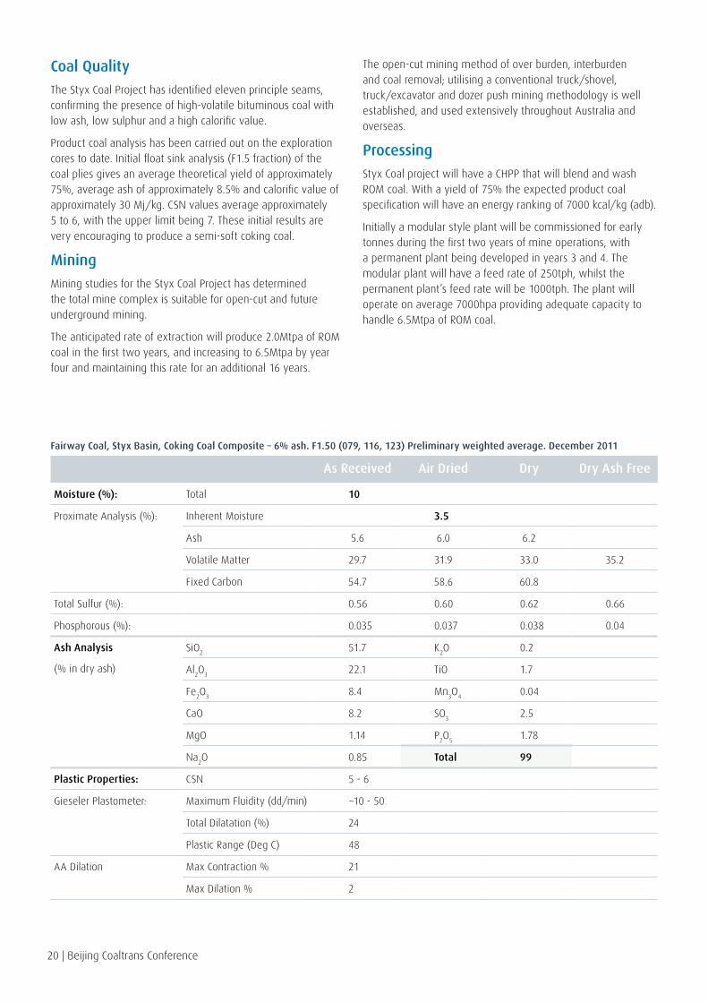
Coal Quality
The Styx Coal Project has identified eleven principle seams, confirming the presence of high-volatile bituminous coal with low ash, low sulphur and a high calorific value.
Product coal analysis has been carried out on the exploration cores to date. Initial float sink analysis (F1.5 fraction) of the coal plies gives an average theoretical yield of approximately 75%, average ash of approximately 8.5% and calorific value of approximately 30 Mj/kg. CSN values average approximately 5 to 6, with the upper limit being 7. These initial results are very encouraging to produce a semi-soft coking coal.
Mining
Mining studies for the Styx Coal Project has determined the total mine complex is suitable for open-cut and future underground mining.
The anticipated rate of extraction will produce 2.0Mtpa of ROM coal in the first two years, and increasing to 6.5Mtpa by year four and maintaining this rate for an additional 16 years.
The open-cut mining method of over burden, interburden and coal removal; utilising a conventional truck/shovel, truck/excavator and dozer push mining methodology is well established, and used extensively throughout Australia and overseas.
Processing
Styx Coal project will have a CHPP that will blend and wash ROM coal. With a yield of 75% the expected product coal specification will have an energy ranking of 7000 kcal/kg (adb).
Initially a modular style plant will be commissioned for early tonnes during the first two years of mine operations, with a permanent plant being developed in years 3 and 4. The modular plant will have a feed rate of 250tph, whilst the permanent plant’s feed rate will be 1000tph. The plant will operate on average 7000hpa providing adequate capacity to handle 6.5Mtpa of ROM coal.
As Received Air Dried Dry Dry Ash Free
Moisture (%): Total 10
Proximate Analysis (%): Inherent Moisture 3.5
Ash 5.6 6.0 6.2
Volatile Matter 29.7 31.9 33.0 35.2
Fixed Carbon 54.7 58.6 60.8
Total Sulfur (%): 0.56 0.60 0.62 0.66
Phosphorous (%): 0.035 0.037 0.038 0.04
Ash Analysis
(% in dry ash)
SiO2
51.7 K2O 0.2
Al2O
322.1 TiO 1.7
Fe2O
38.4 Mn
3O
40.04
CaO 8.2 SO3
2.5
MgO 1.14 P2O
51.78
Na2O 0.85 Total 99
Plastic Properties: CSN 5 - 6
Gieseler Plastometer: Maximum Fluidity (dd/min) ~10 - 50
Total Dilatation (%) 24
Plastic Range (Deg C) 48
AA Dilation Max Contraction % 21
Max Dilation % 2
Fairway Coal, Styx Basin, Coking Coal Composite – 6% ash. F1.50 (079, 116, 123) Preliminary weighted average. December 2011

Rail
Styx Coal rail spur will tie into the existing Queensland Rail (QR) rail network, transporting coal to the port sites of Dalrymple Bay, Abbott Point, Townsville and WICET. The mines geographical location allows for port flexibility to supply a variety of customers.
The QR North Coast Line travels through the eastern portion of EPC 1029, allowing for cost effective rail spur construction. The QR North Coast Line is rated at 20t axle load and capable of handling train lengths of 700m. The train configuration consists of 3 locomotives and 42 wagons each carrying 62.5t of coal for a total train payload of 2,625t. Planned upgrades by QR to the North Coast Line will allow larger train consists of 4 locomotives and 66 wagons with payloads of 4,125t to deliver coal to the nominated ports.
Port
Coal ports within close proximity of the mine site include Dalrymple Bay, Abbott Point, Townsville and Wiggins Island (Gladstone).
The port of Dalrymple Bay, located 163km north of the mine site is operated by Dalrymple Bay Coal Terminal management. Dalrymple Bay currently handles 68Mtpa with planned expansion of up to 85Mtpa.
The terminal has a purpose-built rail in-loading facilities, on-shore stockpile yards, and off-shore wharves. The off-
shore wharves service three shiploaders, with berths cable of handling Capsize vessels.
Abbot Point located further north is 405km from the mine site. Waratah Coal is currently developing the China First Coal port facilities at Abbott Point which will have a handling capacity of 240Mtpa. The port facilities include rail load out, coal stockyards, out loading conveyors, trestle jetty, ship loaders and berth arrangement to support the export of 240Mtpa of product coal. These facilities are due to come online in year 2015.
Port of Townsville managed by Port of Townsville Limited is approximately 515km north of mine site. Through port user BHP existing infrastructure can be utilised to export up to 2Mtpa of Styx coal. Port of Townsville limited is investigating and securing approvals for expansion works for future capacities of 20Mtpa.
WICET is located in Gladstone located 242km south and will be operated by Gladstone Ports Corporation on behalf of the WICET consortium.
WICET will have an ultimate throughput capacity of about 87Mtpa which will be a staged development consistent with port capacity demands from the various coal proponents. The port facilities will include train load out, stockyard storage, reclaim, conveying and wharfing.
275kv Powerline
Toolo
om
bah
Deep
Cre
ek
Cre
ek
Barrack
Creek
B R U C E H I G H WA Y
R o a dS h a n n o n
Og m
o r e
Co n n e c t i o n
R o a d
No r t h
C o a s t
R a i l wa y
Bowman
Train Loading Facility
ROM Stockpile
ProductStockpile
Coal Handling and Preparation Area
Rail Siding
Site Access Road
Spoil
Spoil
MDL
MD
L
Pit 2
Pit 1North
Pit 1South
2500m0
MamelonHomestead
Beijing Coaltrans Conference | 21

22 | Beijing Coaltrans Conference
COKING COAL PROJECTBl
ackw
ater
EPC
118
6 –
Bow
en B
asin Bowen Basin
The Bowen Basin covers an area approximately 160,000km² in Central Queensland and contains gently folded strata of permian and triassic age. The basin is bounded along its western margin by a relatively stable block of older sedimentary, metamorphic, and intrusive rocks (the Clermont Stable Block). To the east of the Bowen Basin lies a mobile belt of volcanic, intrusive and sedimentary rocks. This belt, the Eungella-Cracow Mobile Belt, was tectonically active during the main phases of deposition in the Bowen Basin, and contains some pene-contemporaneous sedimentary units.
The permian coals of the Bowen Basin account for approximately 70%, of Queensland’s coal inventory. Shallow coal that is potentially amenable to open-cut mining makes up about 55% of the inventory, with the remaining 45% present at greater depths.
Waratah Coal holds several exploration permits for coal in the central Bowen Basin two of which are, the Blackwater Project (EPC 1186) and the Capella Project (EPC 1183), covering an area of approximately 740km².
The Capella Project (EPC 1183) is targeting coal seams in the Freitag Formation, whilst the Blackwater Project (EPC 1186) is targeting coal seams in the Rangal Coal Measures.
Blackwater Project EPC 1186 – Bowen Basin
The Blackwater Project covers an area of 75km² and is located 8km east of Blackwater in central Queensland.
Coal Bearing Formation
The coal bearing units in the lease are the Rangal Coal Measures, which are the uppermost permian unit of the Bowen Basin. The coal seams found within the Rangal Coal Measures in the project area are known to be the Aries, Gemini, Orion and Pisces. Historical data states that the thickness of the Rangal Coal Measures in the southern Bowen Basin increases to the west, while the rank increases to the east. The Blackwater Project lies to the west of the north-west trending Jellinbah Thrust fault.
Target Coal Seams
The Blackwater Project is targeting the Rangal Coal Measures. The neighbouring BMA Blackwater and Caledon Cook mine extract seams from the Rangal Coal Measures with an average thickness of 7m. Stanmore Coal’s project to the south of the Blackwater Project area report an average cumulative coal thickness of 15m across EPC 1114.
Coal Quality
The Rangal Coal Measures in the Blackwater area are known to include thermal and export quality medium volatile coking coals and historical data states an increase in the rank of the coals moving to the east, in the area of the Blackwater Project.
Exploration
Waratah Coal has completed an initial exploration drilling program in the Blackwater Project area in 2009. Chip samples taken from this program and analysed proximate the results of which show moderate ash values (16-20% ad) and CSN values of 6.5 in the deepest intersection of coal.
Stamore Coal hold the EPC “Belview” directly to the south of the Blackwater Project (EPC 1114), and have publically reported a high quality, underground coking coal resource of 95Mt Indicated resource (JORC) and an exploration target for a further 205Mt to 345Mt. It is likely with the understanding of the geology in the Blackwater area that the high quality coking coal seams would extend north into the Blackwater Project area.
Mining
The depth, thickness and low dip (3° to 4°) makes the target Rangal Coal Measures in the Blackwater Project potentially suitable for underground mining. It should be noted that there are several thrust fault complexes in this area of the Bowen Basin, however many underground mines have operated in the Blackwater area for many years.
Infrastructure
The southern Bowen Basin region is serviced by the Blackwater rail system, which travels through EPC 1186. This existing system currently transports export coal from twelve existing coal mines to the Port of Gladstone RG Tanna Coal terminal and Barney Point Coal terminal.
Queensland Rail National is currently increasing rail capacity to a further 130Mtpa, being delivered to Stages 1 and 2 of the WICET. Stage 1 WICET capacity is 27Mtpa and Stage 2 is 60Mtpa. Spare capacity of rail and port will be utilised by the Blackwater Project.
EMERALDGERMAN CREEK
AREA
COMETAREA
GERMAN CREEKAREA
BLACKWATERGROUP
GERMANCREEK
FORMATION
INGELARAFORMATION
MARIAFORMATION
FREITAG FORMATION
CROCKERFORMATION
REWAN FORMATION
RANGAL COAL MEASURES
BURNGROVE FORMATION
FIAR HILL FORMATION
MACMILLAN FORMATION
GERMAN CREEKCOAL MEASURES
BLENHEIMGROUP
Beijing Coaltrans Conference | 23
PROJECT AVAILABLE FOR JOINT VENTURE
FAULT
0 5km
ARTHURS BLUFFSTATE FOREST
BLACKDOWN TABLELANDNATIONAL PARK
710 000mE
700 000mE
7 400 000mN
7 380 000mN
7 390 000mN
Waratah Coal Inc.
BLACKWATER EPCA 1186
REGIONAL GEOLOGY
Blackwater CAPRICORN
CENTRAL
HIGHWAY
RAILWAY
Bluff
Rail to GladstoneRoad to Rockhampton
BLACKWATER
CREEK
Sand, soil, gravel, ferruginous gravel and reworked laterite
Sandy gravel
Alluvial sand, silt and gravel
Sandstone, siltstone, claystone, conglomerate, oil shale, Minor basalt
Sandstone breccia
Rewan FormationMudstone, interbeds of lithic sandstone
Clematis SandstoneCross-bedded quartz sandstone, some siltstone interbeds
Sagittarius SandstoneFeldspathic and lithic sandstone with mudstone interbedsRangal Coal MeasuresCarbonaceous mudstone, siltstone, coal, feldspathic and lithic sandstone, calcareous in places, tuff
This map has been prepared for the Information Memorandum of Waratah Coal Inc. by David Campbell who is a qualified person for the purpose of the Listing Rules.This map utilises data sourced from 1 :250 000 surface geology mapping and Bowen Basin Solid Geology mapping sheets.This map contains data provided by the Environmental Protection Agency 2008 which give no warranty in relation to the data (including accuracy, reliability, completeness or suitability) and accepts no liability (including without limitation, liability in negligence) for any loss, damage or costs (including consequential damage) relating to any use of the data.
Road - minor / track
Road - secondary
Railway
EPC - Granted
Protected Areas
Town
River / Creek
Road - major / highway
EPC 1186
Blackwater EPC 1186 – Bowen Basin – Regional Geology
Blackwater EPC 1186
24 | Beijing Coaltrans Conference
COKING COAL PROJECTCa
pella
EPC
118
3 –
Bow
en B
asin Capella Project EPC 1183 – Bowen Basin
The Capella Project covers an area of 663km² and is located approximately 40km north of Emerald and 15km east of Capella in central Queensland.
Coal Bearing Formation
The coal bearing unit in the Capella Project area, is the Freitag Formation which contains the Liskeard Seam and its Rider seam.
The German Creek Formation is known to exist in the majority of the Bowen Basin and hosts many economically extractable coal seams. The German Creek formation is present in the tenement area. Tertiary basalt overlies large parts of the permian strata in the Capella Project area.
Target Coal Seams
The upper 10m of the Frietag Formation contains the Liskeard and Liskeard Rider seams. The Rider seam ranges in thickness from 0.1m to 0.3m and is separated from the underlying Liskeard seam by 0.2m to 2m of fine to medium grained, bioturbated sandstone and carbonaceous siltstone. The Liskeard seam ranges from 0.5m to 1.7m in thickness, and averages at approximately 1m. The recent Waratah Coal drilling confirmed the presence of the Liskeard and the Liskeard Rider seams in the Capella Project area.
Examination of historical data and the compilation of more recent data available in the public domain, have resulted in the delineation of an initial target area that is thought to have the greatest potential for the delineation of potential coking coal seams. This target area is in the east of the tenement adjacent to the mining leases held by Gregory Mine (BHP) and the Kestrel extension (Queensland Coal Pty Ltd).
Coal Quality
The target Liskeard seam is known to be a high fluidity coking coal with elevated sulphur. Historical literature reports a raw ash of approximately 26% and total sulphur approximately 9%, this is dominated by pyritic sulphur which can be substantially washed out with a clean coal fluidity of >30,000ddpm reported. The swell is typically in the order of 7.5.
Mining
Mining potential for the Capella Project is reliant on defining shallow open-cut potential areas with reasonably low strip ratios. The coal seam thicknesses currently modelled lean towards this method of mining.
Infrastructure
The Capella Project requires a 10km rail spur to access the Goonyella and Blackwater rail network. The Goonyella rail network is fully electrified and uses 10,000t trains with high utilisation, giving the system an overall capacity of 132Mtpa. Goonyella rail network transports export coal to the ports of Dalrymple Bay and Hay Point. Dalrymple Bay Coal Terminal has a capacity of 85Mtpa with future expansions up to 153Mtpa. Connection to Blackwater rail network enables an option to export coal via Gladstone’s 105Mtpa ports.
Power will come directly from Lillyvale substation, located 10km east of the Capella Project. The substation is managed by Power Link.

Beijing Coaltrans Conference | 25
PROJECT AVAILABLE FOR JOINT VENTURECapella EPC 1183 – Bowen Basin – Regional Geology
BURNSTATE
FORESTKETTLESTATE
FOREST
CRYSTAL CREEKSTATE FOREST
BUNDOORASTATE
FOREST
LLANDILLOSTATE_FOREST
FAIRBAIRNSTATE FOREST
600 000mE 650 000mE
7 450 000mN
7 400 000mN
0 20km
CAPRICORN
GREGORY
CENTRAL RAILWAYHIGHWAY
HIG
HW
AY
Capella
Tieri
EMERALD
Rai l to G ladstoneRoad to Rockhampton
To C lermont
Road - minor / track
Road - secondary
Railway
EPC - Granted
Protected Areas
Town
River / Creek
Road - major / highway
This map has been prepared for the Information Memorandum of Waratah Coal Inc. by David Campbell who is a qualified person for the purpose of the Listing Rules.This map utilises data sourced from 1 :250 000 surface geology mapping and Bowen Basin Solid Geology mapping sheets.This map contains data provided by the Environmental Protection Agency 2008 which give no warranty in relation to the data (including accuracy, reliability, completeness or suitability) and accepts no liability (including without limitation, liability in negligence) for any loss, damage or costs (including consequential damage) relating to any use of the data.
Waratah Coal Inc.
EPC 1183
REGIONAL GEOLOGY
EPC 1183
Nogoa
River
Rewan Formation
Rangal Coal Measures
Peak Range Volcanics
Burngrove Formation
Faith Hill Formation
Macmillan Formation
German Creek Formation
Ingelara Formation
Back Creek Group
Aldebaran Sandstone
Colinlea Sandstone
Reids Dome Beds
Torsdale Volcanics
Retreat Granite Suite
Fork Lagoon Beds
Anakie Metamorphics
Metamorphics - palaeozoic
Capella EPC 1183
26 | Beijing Coaltrans Conference
COKING COAL PROJECTFa
irlig
ht E
PC 1
058
– La
ura
Bas
in Laura Basin
The Laura Basin is located in north Queensland; the centre of the basin is approximately 145km west, northwest of Cooktown, and approximately 260km northwest of Cairns. The basin is a shallow, elongate intracratonic sag basin approximately half of which is off-shore.
The Laura Basin is relatively undeveloped as a coal resource but historical exploration and mining noted the presence of two main coal bearing formations the permian age Little River Coal Measures (and equivalents) that are overlaid unconformably by the jurassic age Dalrymple Sandstone. Coking coal resources have been defined by Bathurst Coal and Power Ltd in the far north of the basin.
Waratah Coal holds two exploration tenements for coal in the Laura Basin, north Queensland. The Cooktown Project (EPC 1059) that is located approximately 25km west of Cooktown covers an area of approximately 170km² and the Fairlight Project (EPC 1058) which is located approximately 40km west of Laura, covers an area of 430km².
Fairlight EPC 1058
Within EPC 1058 the permian coal measures occupy a narrow tract of country some 25km long and up to 2km wide, bounded on both sides by meridional faults which are part of the Palmerville Fault System. The major Palmerville Fault lies to the west; to the east is a high angle reverse fault (known as the Fairlight Fault) which was associated with the late permian orogenesis. widespread deposition of jurassic and early cretaceous sandstones in the Laura Basin took place across much of the northern part of the Hodgkinson Basin. The permian rocks are overlain unconformably by the Jurassic Dalrymple Sandstone, a conglomerate and sandstone sequence which forms a prominent scarp 100m high on the western side of the Little Kennedy River valley. Late permian orogenesis has resulted in intense deformation of the Little River Coal Measures.
Coal Bearing Formation
The Fairlight Project is interpreted to contain two coal bearing formations, the Permian age Little River Coal Measures that are overlain unconformably by the jurassic age Dalrymple Sandstone Coal Measures.
The permian age Little River Coal Measures crop out at surface and are thought to be equivalents of the Bandanna and Rangal coals found in central Queensland. Both the Dalrymple Sandstone and the Little River Coal Measures based on the regional mapping are interpreted to crop out at surface in the Fairlight Project area covered by EPC 1058.
Target Coal Seams
The Dalrymple Sandstone is known to contain four coal bearing units/seams – Marrett seams, Kalpowar seams, Melaville seam and the Bathurst seam. Historical data reports that Bathurst Coal and Power Ltd, then Utah Development Company (Utah-BHP), developed a 50.8Mt resource of high quality coking coal of the Bathurst seam in EPCs in the northeast of the Laura Basin approximately 100km north of the Fairlight Project. The Bathurst seam, found in the Dalrymple Sandstone is composed of high quality coking coal.
Coal Quality
Bathurst Coal and Power Ltd noted that the coking coal of the Bathurst seam could be washed to produce a high yielding, low ash, high swelling coking coal.
Beijing Coaltrans Conference | 27
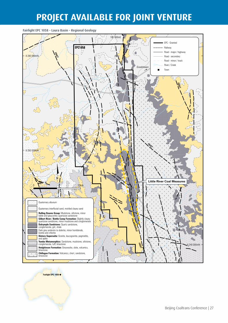
PROJECT AVAILABLE FOR JOINT VENTUREFairlight EPC 1058 – Laura Basin – Regional Geology
FAULT
FAULT
PALMERSVILLE
FAULT
FAULT
FAUL
T
0 10km
180 000mE
8 280 000mN
8 260 000mN
8 240 000mN
Waratah Coal Inc.
FAIRLIGHT EPC1058
REGIONAL GEOLOGY
This map has been prepared for the Information Memorandum of Waratah Coal Inc. by David Campbell who is a qualified person for the purpose of the Listing Rules.This map utilises data sourced from 1 :250 000 surface geology mapping and Bowen Basin Solid Geology mapping sheets.
Chillagoe Formation: Volcanics, chert, sandstone,limestone
Yambo Metamorphics: Sandstone, mudstone, siltstone,conglomerate, tuff, limestone
Dark grey andesite to dolerite, minor hornblende,biotite and chloriteKintore Supersuite: Granite, leucogranite, pegmatite,and aplite
Gilbert River / Battle Camp Formation: Slightly clayeyquartzose sandstone, minor mudstone and conglomerate
Rolling Downs Group: Mudstone, siltstone, minorlabile and glauconitic quartzose sandstone
Quaternary interfluvial sand, mottled clayey sand
Quaternary alluvium
Hodgkinson Formation: Greywacke, slate, volcanics,limestone
Dalrymple Sandstone: Quartz sandstone,conglomerate, grit, shale
Road - minor / track
Road - secondary
Railway
EPC - Granted
Town
River / Creek
Road - major / highway
EPC1058
Cooktown
Little River Coal Measures
Fairlight EPC 1058
28 | Beijing Coaltrans Conference
COKING COAL PROJECTCo
okto
wn
EPC
1059
– L
aura
Bas
in Coal Bearing Formation
The Cooktown Project is interpreted to contain a coal bearing sequence in the permian age Normanby Formation, which occurs as three small faulted outliers within a preserved rift basin in the Barron Range.
The permian age sequence data has been collated from a review of historical data, namely works carried out by or on behalf of, CRA Exploration in the mid-1970s. Seams were reported to be vitrinite rich, strongly deformed and high rank. A total of 21 outcrops were documented.
Target Coal Seams
Three coal outcrops are reported to exist along a fault zone within EPC 1059, particularly in the area immediately north of Mt McCormack.
Coal Quality
Historical data reports the coal to be possible anthracite rank. Further coal quality testing is required to fully understand the coal quality attributes of the Normanby Formation.
Infrastructure
The port of Cape Flattery is a deep water port located 45km north of Cooktown. The port services Cape Flattery Mining activities and facilitates the exporting of silica sands.
The port has a single berth established on a 500m trestle and is serviced by a travelling ship loader. The seaway approach has a lowest astronomical tide (LAT) depth of 26m and berthing pocket depth of 14.1m LAT. Panamax sized vessels with cargo carrying capacities of 50,000 to 70,000dwt are able to utilise berthing this pocket.
In shipping terms Cape Flattery has a two to three day sea way cost advantage over Gladstone, Dalrymple Bay and Abbott Point, being up to 780 nautical miles closer to China.
Beijing Coaltrans Conference | 29
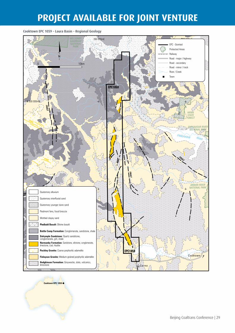
PROJECT AVAILABLE FOR JOINT VENTURECooktown EPC 1059 – Laura Basin – Regional Geology
DYKE
DYKE
MELSONBYGAARRAAYNATIONAL
PARK
HANNSTATE
FOREST
ENDEAVOUR RIVERNATIONAL PARK
ANNAN RIVERNATIONAL PARK
FAULT
FAULT
FAULT
0 10km
280 000mE 300 000mE
8 300 000mN
8 280 000mN
Cooktown
Cai rns
ENDEAVOUR RIVER
Quaternary interfluvial sand
Quaternary younger dune sand
Quaternary alluvium
Battle Camp Formation: Conglomerate, sandstone, shale
Mottled clayey sand
Piedbald Basalt: Olivine basalt
Hodgkinson Formation: Greywacke, slate, volcanics,limestone
Dalrymple Sandstone: Quartz sandstone,conglomerate, grit, shaleNormanby Formation: Sandstone, siltstone, conglomerate,limestone, coal, rhyolite
Finlayson Granite: Medium-grained porphyritic adamelite
Puckley Granite: Coarse porphyritic adamelite
Piedmont fans, fossil breccia
This map has been prepared for the Information Memorandum of Waratah Coal Inc. by David Campbell who is a qualified person for the purpose of the Listing Rules.This map utilises data sourced from 1 :250 000 surface geology mapping.This map contains data provided by the Environmental Protection Agency 2008 which give no warranty in relation to the data (including accuracy, reliability, completeness or suitability) and accepts no liability (including without limitation, liability in negligence) for any loss, damage or costs (including consequential damage) relating to any use of the data.
Road - minor / track
Road - secondary
Railway
EPC - Granted
Protected Areas
Town
River / Creek
Road - major / highway
EPC1059
EPC1059
COOKTOWN EPC1059
REGIONAL GEOLOGY
Cooktown EPC 1059

30 | Beijing Coaltrans Conference
THERMAL COAL PROJECTSt
rath
pine
EPC
101
5 –
Sura
t B
asin Surat Basin
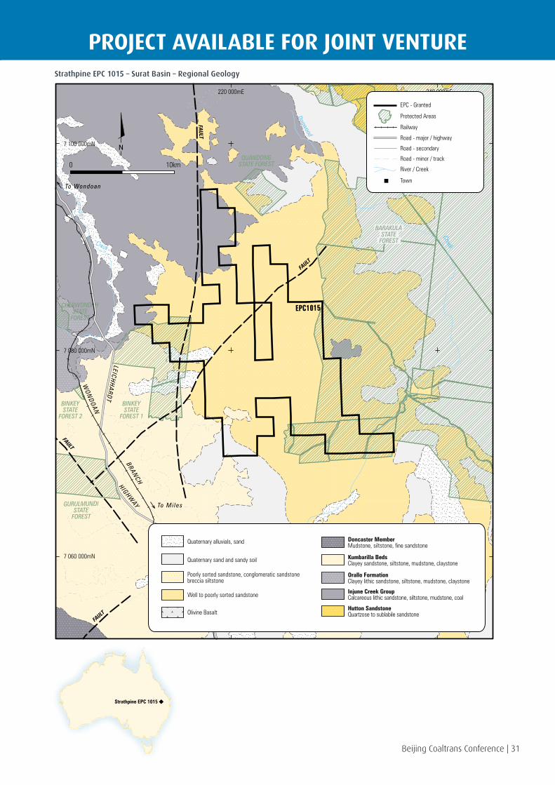
The Surat Basin covers an area of approximately 270,000km² of Southern Queensland, with the main economic coal bearing formation being the jurassic age Walloon subgroup.
The Strathpine Project area lies within the Surat Basin, which is continuous with the Moreton Basin across the Kumbarilla ridge near Dalby.
Regionally the Walloon subgroup dips gently towards the south-west, and is comprised of a thick sequence of interbedded coal and sediments with two major coal measures informally named the Juandah and the Taroom.
Waratah Coal holds one exploration lease for coal in the Surat Basin, Central Queensland. The Strathpine Project is located approximately 25km north of Miles and 15km south of Wandoan and covers an area of 186km².
Coal Bearing Formation
The coal seams in the Strathpine Project area are interpreted to be found within the Taroom Coal Measures. The immediately overlying Tangalooma sandstone unit is known to occur in the western portion of the tenement, and in some areas it is possible that the lower seams of the Juandah coal measures (Argyle and Iona) may also subcrop. Coal deposits in the Surat Basin are known to exist in pods with areas of increased coal thickness, somewhat like a sub-basin.
Target Coal Seams
Waratah Coal is targeting the coal seams in the Juandah and the Taroom Coal Measures. Historical data and data available in the public domain from adjacent EPCs indicated that the Juandah and Taroom Coal Measures are present and are viable for open-cut mining.
Regionally, the Taroom Coal Measures have an approximate cumulative coal thickness of 7-10m, and the Juandah Coal Measures of 10-20m.
Stanmore Coal’s project “The Range” is immediately to the north of EPC 1015, and this project has progressed to a Mining Lease Application for an open-cut pit mining the three main seam groups of the Taroom Coal Measures. To date Stanmore Coal has reported 229Mt of JORC compliant coal resources.
Waratah Coal has further exploration drilling planned with the aim of defining the same coal seams as the Cockatoo Coal Tin Hut Coal Resource who hold a mining development lease application immediately west of the Strathpine Project area. Cockatoo has announced a JORC Resource of 344Mt (Indicated and Inferred) in their Tin Hut Project area.
Exploration
The area of the present EPC was selected based on information available from the Geological Survey of Queensland (GSQ) who undertook several studies of the area including geological mapping, geophysical studies and exploration drilling. The results of one of the exploration drill holes, ‘Strathpine 1’, reported a cumulative coal thickness of 38m within the first 100m of drilling.
Further exploration is planned during 2012 in the areas closer to the surrounding advanced projects of The Range and Tin Hut Creek.
Coal Quality
Historical data of the area covered by the Strathpine Project state the coal has high volatile content. Taroom coal measures can be washed with high yields to produce high volatile and low ash thermal product coal.
Mining
With further exploration and development it is proposed to define a potential shallow open-cut mining area, with selective mining methods to be adopted to maximise coal recovery and yield.
Infrastructure
Significant work is underway on major infrastructure projects to enable coal export from the Surat Basin through the WICET at the Port of Gladstone.
The proposed Surat Basin Railway (SBR) will connect the mine activity in the Surat Basin to the existing Moura rail system through to WICET. QR is progressing plans for upgrading track capacity on the Moura rail system up to 70Mtpa to support the development of the WICET and SBR. WICET will initially create capacity of 27Mtpa ramping up to 87Mtpa of additional terminal capacities. Strathpine Project will connect to the SBR via a new 25km rail spur and export coal through Stage 2 of WICET.
Springbrook Sandstone
Kogan
SEAM
Macalister UpperMacalister LowerNangram
Wambo
Iona
Argyle
AuburnBulwer UpperBulwer Lower
Condamine
0
150
300
Juandah Coal Measures
Tangalooma Sandstone
Taroom Coal MeasuresWA
LL
OO
N
S
UB
GR
OU
P
Durabilla Formation
Eurombah Formation
Beijing Coaltrans Conference | 31
PROJECT AVAILABLE FOR JOINT VENTUREStrathpine EPC 1015 – Surat Basin – Regional Geology
BARAKULASTATE
FOREST
BINKEYSTATE
FOREST 1
BINKEYSTATE
FOREST 2
CHERWONDAHSTATE
FOREST
GURULMUNDISTATE
FOREST
FAULT
FAULT
FAULT
FAULT
220 000mE 240 000mE
7 100 000mN
7 080 000mN
7 060 000mN
Dogwood
Creek
Juanadah
Creek
EPC1015
To Wondoan
To Mi les
WO
ND
OA
N
LEICH
HA
RD
T
H IGHWAY
BRANCH
Quaternary sand and sandy soil
Poorly sorted sandstone, conglomeratic sandstonebreccia siltstone
Quaternary alluvials, sand
Olivine Basalt
Well to poorly sorted sandstone
Kumbarilla BedsClayey sandstone, siltstone, mudstone, claystone
Doncaster MemberMudstone, siltstone, fine sandstone
Orallo FormationClayey lithic sandstone, siltstone, mudstone, claystone
Injune Creek GroupCalcareous lithic sandstone, siltstone, mudstone, coal
Hutton SandstoneQuartzose to sublabile sandstone
This map has been prepared for the Information Memorandum of Waratah Coal Inc. by David Campbell who is a qualified person for the purpose of the Listing Rules.This map utilises data sourced from 1 :250 000 surface geology mapping and Bowen Basin Solid Geology mapping sheets.This map contains data provided by the Environmental Protection Agency 2008 which give no warranty in relation to the data (including accuracy, reliability, completeness or suitability) and accepts no liability (including without limitation, liability in negligence) for any loss, damage or costs (including consequential damage) relating to any use of the data.
QUANDONGSTATE FOREST
Road - minor / track
Road - secondary
Railway
EPC - Granted
Protected Areas
Town
River / Creek
Road - major / highway
0 10km
STRATHPINE EPC1015
REGIONAL GEOLOGY
Strathpine EPC 1015
32 | Beijing Coaltrans Conference
COKING COAL PROJECT
Beijing Coaltrans Conference | 32
Kola
n Ri
ver
EPC
1268
– M
aryb
orou
gh B
asin Maryborough Basin
The Maryborough Basin is an extensive sedimentary basin occupying part of the Central Queensland coastal belt running between Gympie in the south to Bundaberg in the north. The Maryborough Basin began as a region of marine sedimentation during the permian age. After a time-break, evidenced by geological unconformity, fresh water sediments were deposited during the triassic and jurassic. Several horizons of coal measures are represented, the most important commercially being the uppermost cretaceous sequence – known as the Burrum Coal Measures.
Waratah Coal holds one exploration lease for coal in the Maryborough Basin, in Central Queensland. The Kolan River Project (EPC 1268) is located approximately 15km west of the major regional town of Bundaberg, and covers an area of 30 sub-blocks.
Coal Bearing Formation
The Burrum Coal Measure formation occupies over 1500km² of low lying coastal terrain. The best of the known seams occur towards the top of the formation and are preserved in a series of north, north-west trending synclines distributed in an en echelon pattern throughout the basin. Coal seams are well defined in particular within the vicinity of the Burrum Syncline in the south of the Maryborough Basin which have been extensively worked by underground methods since the late 1800s.
Target Coal Seams
The Burrum Coal Measures support relatively thin coal seams of high volatile bituminous coal and are one of the few examples of cretaceous coal deposits in Australia. Coal seams of the Burrum Coal Measures can vary in thickness and quality over relatively short distances.
Coal Quality
Historic sampling from previous drilling and outcrop sampling has indicated that the coal is very clean (ash 4.4%) with a quality acceptable for metallurgical use (medium volatile coal with a reported swelling index of 8.5) which significantly increases the attractiveness of this prospective region.
Infrastructure
The Kolan River Project would connect to the existing North Coast railway and transport export coal using the narrow gauge rail system to access the new WICET expansion at the Port of Gladstone. Stage 1 of the WICET will initially create export capacity of 27Mtpa this will expand in stages to possibly 87Mtpa of additional terminal capacity depending on demand.
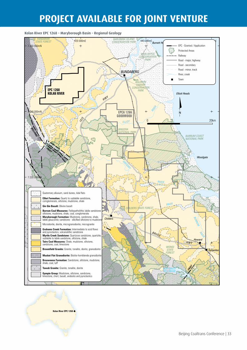
Beijing Coaltrans Conference | 33
PROJECT AVAILABLE FOR JOINT VENTUREKolan River EPC 1268 – Maryborough Basin – Regional Geology
WONGISTATE
FOREST
CHILDERS STATE FOREST
BURRUM COASTNATIONAL PARK
BINGERANATIONAL PARK
BALDWINSWAMP
CONSERVATIONPARK
MON REPOSCONSERVATION
PARK
BARUBBRA ISLANDCONSERVATION PARK
YANDARANSTATE FOREST
ELLIOTRIVERSTATE
FOREST
BULLYARD
FAULT
FAULT
FAUL
T
0 20km
420 000mE 440 000mE 460 000mE
7 260 000mN
7 240 000mN
7 220 000mN
7 200 000mN
BUNDABERG
Burnett Heads
Elliott Heads
Woodgate
Childers
Howard
Torbanlea
LENTHALLSRESERVOIR
EPC 1268KOLAN RIVER
EPCA 1266GOODWOODBURNETT ELLIOT
GREGORY
ISIS BURRUM
RIVER
RIVER
RIVER
RIVE
RRIVER
BRUCE
IS IS
ISIS
HWY
HWY
HWY
Road - minor, track
Road - secondary
Railway
EPC - Granted / Application
Protected Areas
Town
River, creek
Road - major, highway
Tawah Granite: Granite, tonalite, diorite
Gympie Group: Mudstone, siltstone, sandstone,limestone, chert, basalt, andesite and pyroclastics
Brooweena Formation: Sandstone, siltstone, mudstone,shale, coal, tuff
Musket Flat Granodiorite: Biotite-hornblende granodiorite
Broomfield Granite: Granite, tonalite, diorite, granodiorite
Tairo Coal Measures: Shale, mudstone, siltstone,sandstone, coal, limestone
Myrtle Creek Sandstone: Quartzose sandstone, quartzite,sublabile to labile sandstone, siltstone, shale
Grahams Creek Formation: Intermediate to acid flowsand pyroclastics, volcanolithic sandstone
Maryborough Formation: Mudstone, sandstone, shale,labile glauconitic sandstone - silicified siltstone to mudstone
Burrum Coal Measures: Feldspatholithic labile sandstonesiltstone, mudstone, shale, coal, conglomerate
Gin Gin Basalt: Olivine basalt
Elliot Formation: Quartz to sublabile sandstone,comglomerate, siltstone, mudstone, shale
Quaternary alluvium, sand dunes, tidal flats
Microdiorite, diorite, microgranodiorite, microgranite
Waratah Coal Inc.
EPC 1268 KOLAN RIVER & EPCA 1266 GOODWOOD
REGIONAL GEOLOGY
This map has been prepared for the Information Memorandum of Waratah Coal Inc. by David Campbell who is a qualified person for the purpose of the Listing Rules.This map utilises data sourced from 1 :250 000 surface geology mapping and Bowen Basin Solid Geology mapping sheets.This map contains data provided by the Environmental Protection Agency 2008 which give no warranty in relation to the data (including accuracy, reliability, completeness or suitability) and accepts no liability (including without limitation, liability in negligence) for any loss, damage or costs (including consequential damage) relating to any use of the data.
Kolan River EPC 1268
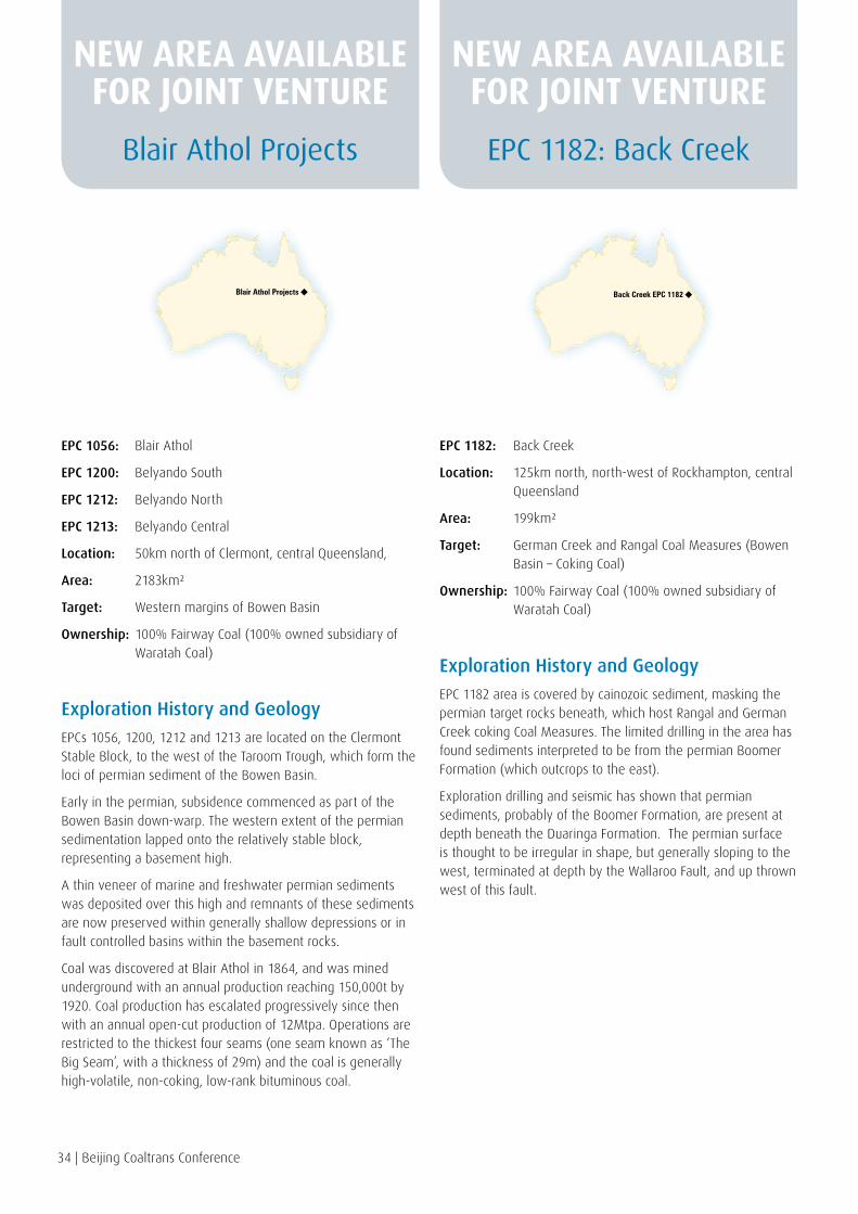
34 | Beijing Coaltrans Conference
EPC 1056: Blair Athol
EPC 1200: Belyando South
EPC 1212: Belyando North
EPC 1213: Belyando Central
Location: 50km north of Clermont, central Queensland,
Area: 2183km²
Target: Western margins of Bowen Basin
Ownership: 100% Fairway Coal (100% owned subsidiary of Waratah Coal)
Exploration History and Geology
EPCs 1056, 1200, 1212 and 1213 are located on the Clermont Stable Block, to the west of the Taroom Trough, which form the loci of permian sediment of the Bowen Basin.
Early in the permian, subsidence commenced as part of the Bowen Basin down-warp. The western extent of the permian sedimentation lapped onto the relatively stable block, representing a basement high.
A thin veneer of marine and freshwater permian sediments was deposited over this high and remnants of these sediments are now preserved within generally shallow depressions or in fault controlled basins within the basement rocks.
Coal was discovered at Blair Athol in 1864, and was mined underground with an annual production reaching 150,000t by 1920. Coal production has escalated progressively since then with an annual open-cut production of 12Mtpa. Operations are restricted to the thickest four seams (one seam known as ‘The Big Seam’, with a thickness of 29m) and the coal is generally high-volatile, non-coking, low-rank bituminous coal.
EPC 1182: Back Creek
Location: 125km north, north-west of Rockhampton, central Queensland
Area: 199km²
Target: German Creek and Rangal Coal Measures (Bowen Basin – Coking Coal)
Ownership: 100% Fairway Coal (100% owned subsidiary of Waratah Coal)
Exploration History and Geology
EPC 1182 area is covered by cainozoic sediment, masking the permian target rocks beneath, which host Rangal and German Creek coking Coal Measures. The limited drilling in the area has found sediments interpreted to be from the permian Boomer Formation (which outcrops to the east).
Exploration drilling and seismic has shown that permian sediments, probably of the Boomer Formation, are present at depth beneath the Duaringa Formation. The permian surface is thought to be irregular in shape, but generally sloping to the west, terminated at depth by the Wallaroo Fault, and up thrown west of this fault.
Blair Athol Projects EPC 1182: Back Creek
Blair Athol Projects Back Creek EPC 1182
NEW AREA AVAILABLE FOR JOINT VENTURE
NEW AREA AVAILABLE FOR JOINT VENTURE
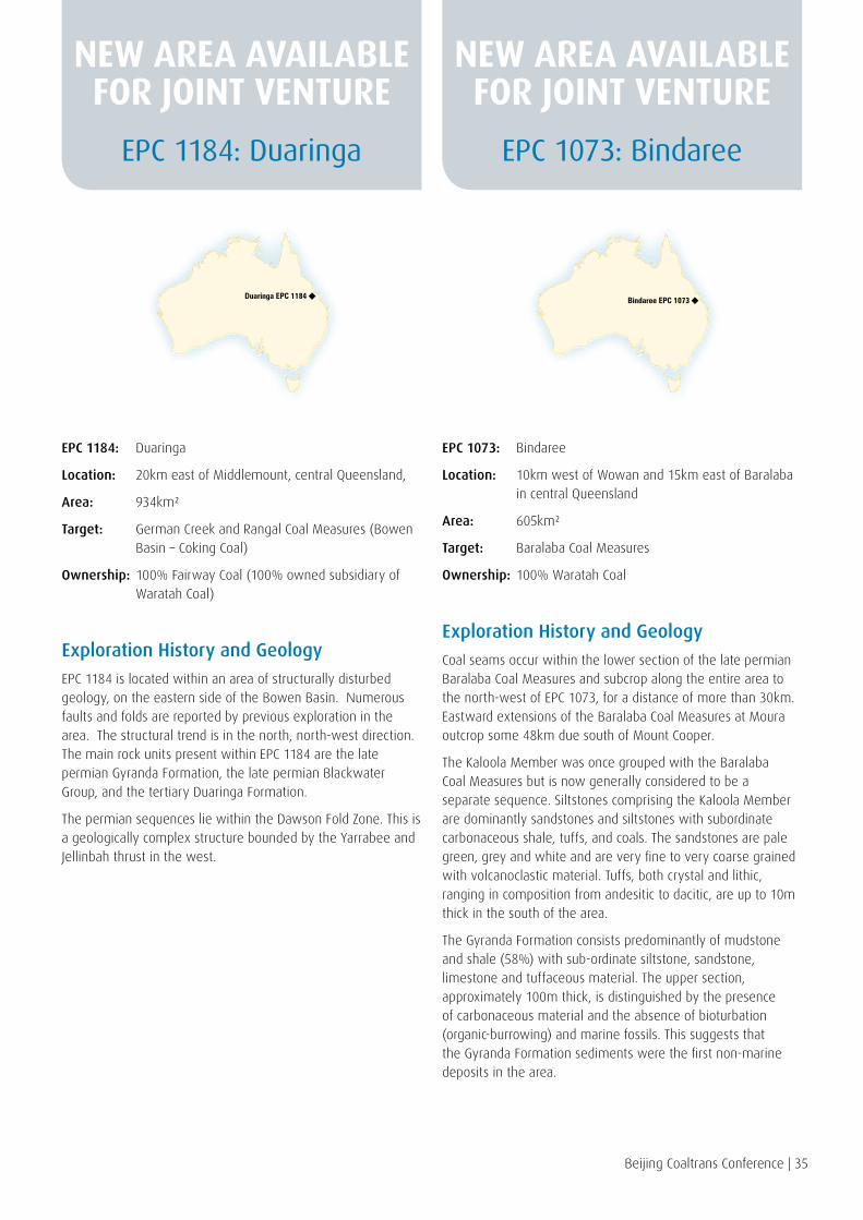
Beijing Coaltrans Conference | 35
EPC 1184: Duaringa
Location: 20km east of Middlemount, central Queensland,
Area: 934km²
Target: German Creek and Rangal Coal Measures (Bowen Basin – Coking Coal)
Ownership: 100% Fairway Coal (100% owned subsidiary of Waratah Coal)
Exploration History and Geology
EPC 1184 is located within an area of structurally disturbed geology, on the eastern side of the Bowen Basin. Numerous faults and folds are reported by previous exploration in the area. The structural trend is in the north, north-west direction. The main rock units present within EPC 1184 are the late permian Gyranda Formation, the late permian Blackwater Group, and the tertiary Duaringa Formation.
The permian sequences lie within the Dawson Fold Zone. This is a geologically complex structure bounded by the Yarrabee and Jellinbah thrust in the west.
EPC 1073: Bindaree
Location: 10km west of Wowan and 15km east of Baralaba in central Queensland
Area: 605km²
Target: Baralaba Coal Measures
Ownership: 100% Waratah Coal
Exploration History and Geology
Coal seams occur within the lower section of the late permian Baralaba Coal Measures and subcrop along the entire area to the north-west of EPC 1073, for a distance of more than 30km. Eastward extensions of the Baralaba Coal Measures at Moura outcrop some 48km due south of Mount Cooper.
The Kaloola Member was once grouped with the Baralaba Coal Measures but is now generally considered to be a separate sequence. Siltstones comprising the Kaloola Member are dominantly sandstones and siltstones with subordinate carbonaceous shale, tuffs, and coals. The sandstones are pale green, grey and white and are very fine to very coarse grained with volcanoclastic material. Tuffs, both crystal and lithic, ranging in composition from andesitic to dacitic, are up to 10m thick in the south of the area.
The Gyranda Formation consists predominantly of mudstone and shale (58%) with sub-ordinate siltstone, sandstone, limestone and tuffaceous material. The upper section, approximately 100m thick, is distinguished by the presence of carbonaceous material and the absence of bioturbation (organic-burrowing) and marine fossils. This suggests that the Gyranda Formation sediments were the first non-marine deposits in the area.
EPC 1184: Duaringa EPC 1073: Bindaree
Duaringa EPC 1184 Bindaree EPC 1073
NEW AREA AVAILABLE FOR JOINT VENTURE
NEW AREA AVAILABLE FOR JOINT VENTURE
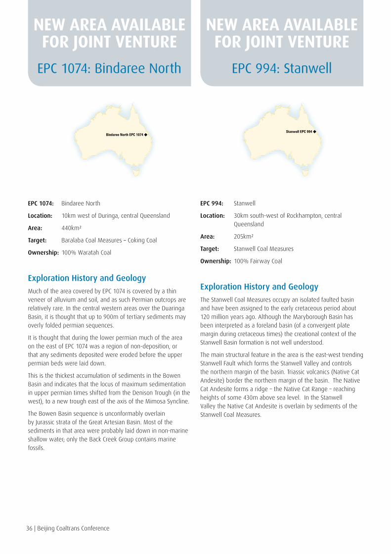
36 | Beijing Coaltrans Conference
EPC 1074: Bindaree North
Location: 10km west of Duringa, central Queensland
Area: 440km²
Target: Baralaba Coal Measures – Coking Coal
Ownership: 100% Waratah Coal
Exploration History and Geology
Much of the area covered by EPC 1074 is covered by a thin veneer of alluvium and soil, and as such Permian outcrops are relatively rare. In the central western areas over the Duaringa Basin, it is thought that up to 900m of tertiary sediments may overly folded permian sequences.
It is thought that during the lower permian much of the area on the east of EPC 1074 was a region of non-deposition, or that any sediments deposited were eroded before the upper permian beds were laid down.
This is the thickest accumulation of sediments in the Bowen Basin and indicates that the locus of maximum sedimentation in upper permian times shifted from the Denison Trough (in the west), to a new trough east of the axis of the Mimosa Syncline.
The Bowen Basin sequence is unconformably overlain by Jurassic strata of the Great Artesian Basin. Most of the sediments in that area were probably laid down in non-marine shallow water; only the Back Creek Group contains marine fossils.
EPC 994: Stanwell
Location: 30km south-west of Rockhampton, central Queensland
Area: 205km²
Target: Stanwell Coal Measures
Ownership: 100% Fairway Coal
Exploration History and Geology
The Stanwell Coal Measures occupy an isolated faulted basin and have been assigned to the early cretaceous period about 120 million years ago. Although the Maryborough Basin has been interpreted as a foreland basin (of a convergent plate margin during cretaceous times) the creational context of the Stanwell Basin formation is not well understood.
The main structural feature in the area is the east-west trending Stanwell Fault which forms the Stanwell Valley and controls the northern margin of the basin. Triassic volcanics (Native Cat Andesite) border the northern margin of the basin. The Native Cat Andesite forms a ridge – the Native Cat Range – reaching heights of some 430m above sea level. In the Stanwell Valley the Native Cat Andesite is overlain by sediments of the Stanwell Coal Measures.
EPC 1074: Bindaree North EPC 994: Stanwell
Bindaree North EPC 1074Stanwell EPC 994
NEW AREA AVAILABLE FOR JOINT VENTURE
NEW AREA AVAILABLE FOR JOINT VENTURE
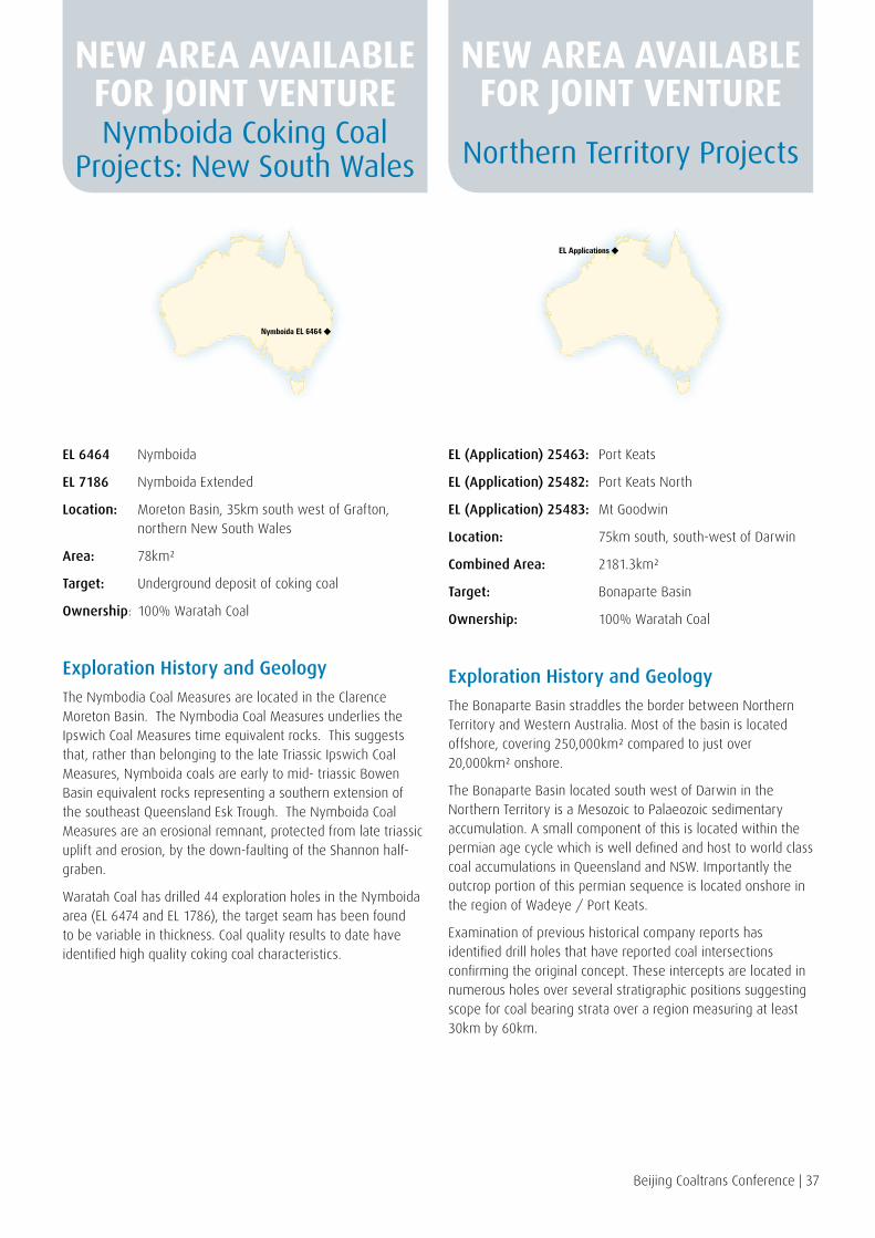
Beijing Coaltrans Conference | 37
EL 6464 Nymboida
EL 7186 Nymboida Extended
Location: Moreton Basin, 35km south west of Grafton, northern New South Wales
Area: 78km²
Target: Underground deposit of coking coal
Ownership: 100% Waratah Coal
Exploration History and Geology
The Nymbodia Coal Measures are located in the Clarence Moreton Basin. The Nymbodia Coal Measures underlies the Ipswich Coal Measures time equivalent rocks. This suggests that, rather than belonging to the late Triassic Ipswich Coal Measures, Nymboida coals are early to mid- triassic Bowen Basin equivalent rocks representing a southern extension of the southeast Queensland Esk Trough. The Nymboida Coal Measures are an erosional remnant, protected from late triassic uplift and erosion, by the down-faulting of the Shannon half-graben.
Waratah Coal has drilled 44 exploration holes in the Nymboida area (EL 6474 and EL 1786), the target seam has been found to be variable in thickness. Coal quality results to date have identified high quality coking coal characteristics.
EL (Application) 25463: Port Keats
EL (Application) 25482: Port Keats North
EL (Application) 25483: Mt Goodwin
Location: 75km south, south-west of Darwin
Combined Area: 2181.3km²
Target: Bonaparte Basin
Ownership: 100% Waratah Coal
Exploration History and Geology
The Bonaparte Basin straddles the border between Northern Territory and Western Australia. Most of the basin is located offshore, covering 250,000km² compared to just over 20,000km² onshore.
The Bonaparte Basin located south west of Darwin in the Northern Territory is a Mesozoic to Palaeozoic sedimentary accumulation. A small component of this is located within the permian age cycle which is well defined and host to world class coal accumulations in Queensland and NSW. Importantly the outcrop portion of this permian sequence is located onshore in the region of Wadeye / Port Keats.
Examination of previous historical company reports has identified drill holes that have reported coal intersections confirming the original concept. These intercepts are located in numerous holes over several stratigraphic positions suggesting scope for coal bearing strata over a region measuring at least 30km by 60km.
Nymboida Coking Coal Projects: New South Wales Northern Territory Projects
Nymboida EL 6464
EL Applications
NEW AREA AVAILABLE FOR JOINT VENTURE
NEW AREA AVAILABLE FOR JOINT VENTURE
Our ConsultantsManagement and staff at Waratah Coal have engaged leading consultants to cover the various disciplines of exploration and mine development.
Waratah Coal fosters a creative and co-operative team spirit with consultants to plan sustainable and integrated exploration and mine development sites.
Waratah Coal through their exploration and development activities look to benefit key stakeholders and communities and strive to eliminate harm to the environment.
consulting engineers
38 | Beijing Coaltrans Conference
Beijing Coaltrans Conference | 39
TRAFFIC PARKING ACOUSTICS. .
ENGENYW A T E R M A N A G E M E N T

40 | Beijing Coaltrans Conference40 | Beijing Coaltrans Conference
Professor Palmer has over 25 years’ experience in the Australian resource industry and has had significant success with major projects. He is Chairman and Founder of Mineralogy Pty Ltd, a private Australian Company that has successfully concluded major transactions with a number of companies including the Chinese Government-owned CITIC Pacific Limited (HK Listed), Australasian Resources Limited (ASX Listed) and a Memorandum of Understanding with Fortescue Metals Limited (ASX Listed). Professor Palmer is also a director of 28 other companies and a leader in the Australian community with business affiliations throughout the world.
Mr Harris has 25 years’ experience in the Mining and Construction industries. He has successfully filled a variety of positions including Owners Representative, Design Manager, Project Manager and Construction Manager. In Queensland he has been involved with the successful development, construction and operations of numerous mine sites within the Bowen Basin. These include Southern Colliery (Shell Coal), Oaky North and Oaky Number One (Xstrata), Moorvale Open-cut (McArthur Coal), Carborough Downs Underground (Vale), Isaac Plains Open-cut (Bowen Central Coal Joint Venture).
He has been involved as a consultant on large scale engineering and mining projects such as Brisbane Bus Way Tunnels managed by Leighton’s, Paradise Dam managed by Sun Water and McArthur River Zinc Open-cut Mine managed by Xstrata. Mr Harris has a Bachelor of Applied Science from Queensland University of Technology.
Mr Nui HarrisMANAGING DIRECTOR
Professor Clive PalmerEXECUTIVE CHAIRMAN
Our TeamDIRECTORS AND MANAGEMENT

Beijing Coaltrans Conference | 41 Beijing Coaltrans Conference | 41
Mr Smith has 28 years’ experience as a lawyer and a senior partner in the prominent Queensland legal firm of Bell Legal Group. Mr Smith has gained extensive experience in commercial litigation, intellectual property and corporate work throughout his long career and has been a registered arbitrator for over 10 years. He is also on the board of a number of community organisations in Gold Coast City including the Gold Coast Titans Community Foundation. Mr Smith retired as a principal of his legal practice to take up his appointment as Managing Director Legal in Mineralogy Pty Ltd.
Ms Singh was appointed Legal Director of Mineralogy in 2008, having joined the Mineralogy Group in 2006. She is also Legal Counsel for Mineralogy’s group company, Waratah Coal Pty Ltd. Since joining Mineralogy, Ms Singh has managed legal matters for the Group’s operations in Western Australia, Queensland, South Australia, Papua New Guinea and Hong Kong. She is experienced in litigation, environmental and native title law and corporate and commercial law in Australia and Hong Kong.
Prior to joining Mineralogy, Ms Singh worked for a law firm specialising in taxation where she gained experience in the Federal Court and the High Court of Australia. Ms Singh holds a Bachelor of Laws and Diploma in Legal Practice from Bond University and is admitted to practice in the Supreme Courts of Queensland and Western Australia and the High Court of Australia.
Mr Payne has a Bachelor of Commerce majoring in Accounting and Finance and in Information Systems and Management Science. He is a Certified Practising Accountant with CPA Australia and a Fellow of the Hong Kong Institute of Public Accountants. He is currently engaged by Mineralogy as Finance Director and as company secretary for the Mineralogy group of companies.
Mr Payne has a wide range of experience in business and financial management issues within a diverse range of industries including broadcasting, performing arts, corrections, financial services, training and mining development.
Mr Geoff SmithLEGAL DIRECTOR
Ms Baljeet SinghLEGAL DIRECTOR
Mr Derek PayneCOMPANY SECRETARY

42 | Beijing Coaltrans Conference42 | Beijing Coaltrans Conference
Mr Tam has a Bachelor degree of Civil & Resources Engineering (University of Auckland, New Zealand), a Master degree of Practising Accounting (Monash University, Australia) and an Executive MBA degree (Richard Ivey School of Business, Canada). He is a Certified Accountant with CPA Australia and the Hong Kong Institute of CPAs, and a CFA/FRM charter-holder. Mr Tam has over 10 years experience in corporate and investment banking in Asia Pacific. He was previously senior Vice President of JPMorgan. He is an Asia Society Asia 21 Young Leader and one of CPA Australia’s Top 40 under 40 (years of age) leaders.
Mr Schoch is a Senior Executive and a Director within the Mineralogy Pty Ltd Group. He has served the Palmer group of companies over a thirty-three year period in a number of capacities and roles. Mr Schoch is a Fellow of the Institute of Chartered Accountants in Australia and is a graduate of the University of Queensland with a Bachelor of Commerce and a Bachelor of Laws.
Mr Yi has a Master of Metallurgical Engineering and also a Master of Mechanical Engineering. He is currently engaged by Waratah Coal as the Beijing Manager.
Mr Yi has over 12 years of mining and industrial experience.
He plays a key role in Mineralogy Pty Ltd’s cooperation with the PRC in iron ore projects and the China First Coal Project. He has been instrumental with relations between Metallurgical Corporation of China and Waratah Coal.
Mr Raymond TamCHIEF FINANCIAL OFFICER
RESOURCE HOUSE
Mr Williamm SchochCHIEF FINANCIAL OFFICER
WARATAH COAL
Mr Yi NingBEIJING MANAGER
WARATAH COAL

Beijing Coaltrans Conference | 43 Beijing Coaltrans Conference | 43
Mr Stodart has a Bachelor degree of Commerce (University of Queensland, Australia), and trained as an Accountant with Ernst & Young Chartered Accountants. He has since worked in the banking, corporate and private sectors, across all industry sectors in Australia, and with a focus on venture and expansion capital with private companies, start up and early stage commercialisation of technology and new businesses. Simon has over 30 years’ experience in Australia and Asia Pacific. He was previously with Ernst & Young and AIFC Merchant Bank (ANZ Bank), and has more recently focused on Australian clean tech technologies, and with applications for the mining and industrial sectors, and specifically was on a project team with an early stage renewable energy (biodiesel) project in China.
Text for Ian ferguson still to come
Mr Keith Zhong has a Bachelor of Accounting Degree (University of Ballarat, Australia), a Master Degree of International Finance (Deakin University, Australia).
Mr Zhong was born and grew up in Beijing, China before embarking on higher education for International Studies in Australia.
Mr Zhong graduated with a Bachelor of Accounting Degree at The University of Ballarat, Australia, and then completed a Master’s Degree of International Finance at Deakin University, Australia.
Mr Zhong commenced his career with Gans Channels Pty Ltd (Telecommunications company) as their National Accounts Manager. He then joined the resources sector working for Queensland Nickel as Finance and Accounts Manager.
Mr Zhong occupies a senior management role with Waratah Coal as their ‘Procurement and Logistics Manager’. As Procurement and Logistics Manager for Waratah Coal, Mr Zhong manages the progress of projects within the Waratah Coal portfolio and frequently travels to China for negotiations and associated duties for contracts and procurement.
Mr Simon StodartCOMMERCIAL DIRECTOR
STYX COAL JOINT VENTURE
Mr Ian FergusonCOMMERCIAL DIRECTOR
STYX COAL JOINT VENTURE
Mr Keith ZhongMANAGER OF CONTRACTS, LOGISTICS &
PROCUREMENT – WARATAH COAL

44 | Beijing Coaltrans Conference
Our FutureWaratah Coal is focused on exporting clean energy coal to the export markets of China, India, Japan and Europe.
With Mineralogy our parent company, Waratah Coal is optimistic of the future with exciting global opportunities and new business success.
Waratah Coal’s future is assured with partnerships and opportunities to compliment and grow our already world class business.
Our people will continue to build a great company that will provide prosperity, growth, jobs and opportunities for Australia and China.
Our Chinese FriendsWaratah Coal has formed close relations with the People’s Republic of China major state owned enterprises. Metallurgical Corporation of China, Sino-coal International, China Railway Group, China Communication Construction Company with Waratah Coal have progressed the China First Coal Project.
China’s Eximbank has signed a letter of intent with Waratah Coal to fund the China First Coal Project.
Coal off take agreement letter of intent has been signed between China Power International and Waratah Coal.
Madam Li Xiaolin – Chairperson of China Power International Holding Ltd, Mr Shen Heting – President of Metallurgical Corporation of China Ltd and Professor Clive Palmer at signing ceremony for China First Project January 29th 2010
Metallurgical Corp. of China
China Railway Group
China Communications Construction
Sino-coal International
China Eximbank
China Power

Signing Ceremony of China First Coal Development Cooperation Agreement
Held in Canberra, Australia in June 2010, signed by Madame Li, Chairperson for China Power International Holding Limited and Domenic Martino, Director of Waratah Coal and as witnessed by Mr Xi Jinping, Vice President of China (President Elect) and The Honourable Kevin Rudd, Prime Minister of Australia at the time
Left to Right: Madame Li Xiaolin, Mr Xi Jinping, The Honourable Kevin Rudd and (seated on right) Mr Domenic Martino
Contact Details
BEIJING OFFICE: Waratah Coal Pty Ltd
Physical Address: Room 401 Building 13 YanJingJiaYuan Beijing Economic-Technological Development Area China 100176
Phone: +86 10 8498 2099
Fax: +86 10 8498 2099
Email: [email protected]
Web: www.waratahcoal.com
Contact: Mr Yi Ning Beijing Manager Waratah Coal Pty Ltd
Mobile: +86 135 2042 4158
Email: [email protected]
HONG KONG OFFICE: Waratah Coal Pty Ltd
Physical Address: Level 19 Two International Finance Centre 8 Finance Street Central Hong Kong China
Phone: +852 3101 7055
Fax: +852 2251 1818
BRISBANE OFFICE: Waratah Coal Pty Ltd
Physical Address: Mineralogy House Level 7, 380 Queen Street Brisbane QLD 4000, Australia
Postal Address: GPO Box 1538 Brisbane QLD 4001, Australia
Phone: +61 7 3233 0800
Fax: +61 7 3221 8870
Contact: Mr Keith Zhong Manager Procurements & Logistics Waratah Coal Pty Ltd
Phone: +61 7 3233 0800
Email: [email protected]
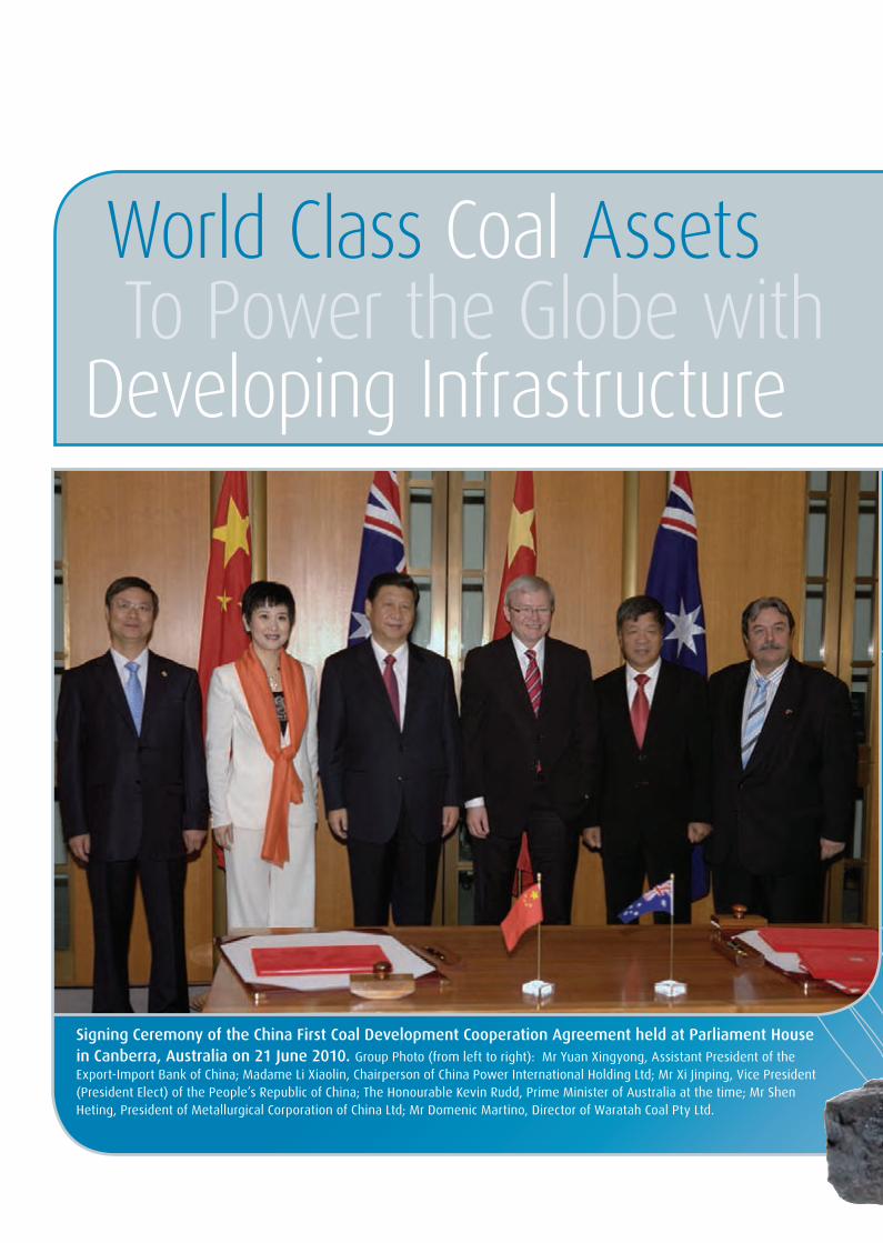
Supply Thermal CoalWorld Class Coal AssetsSupply Coking CoalTo Power the Globe with Clean Coal
Joint Venture InterestDeveloping Infrastructure
Waratah Coal exporting clean energy coal to China
Signing Ceremony of the China First Coal Development Cooperation Agreement held at Parliament House in Canberra, Australia on 21 June 2010. Group Photo (from left to right): Mr Yuan Xingyong, Assistant President of the Export-Import Bank of China; Madame Li Xiaolin, Chairperson of China Power International Holding Ltd; Mr Xi Jinping, Vice President (President Elect) of the People’s Republic of China; The Honourable Kevin Rudd, Prime Minister of Australia at the time; Mr Shen Heting, President of Metallurgical Corporation of China Ltd; Mr Domenic Martino, Director of Waratah Coal Pty Ltd.