Embed Size (px)
Citation preview

A WORLD BANK COUNTRY STUDY
Pw
BRAZILIntegrated Development of the Northwest Frontier
r
N,
JUNE 1981
Pub
lic D
iscl
osur
e A
utho
rized
Pub
lic D
iscl
osur
e A
utho
rized
Pub
lic D
iscl
osur
e A
utho
rized
Pub
lic D
iscl
osur
e A
utho
rized
Pub
lic D
iscl
osur
e A
utho
rized
Pub
lic D
iscl
osur
e A
utho
rized
Pub
lic D
iscl
osur
e A
utho
rized
Pub
lic D
iscl
osur
e A
utho
rized
Pub
lic D
iscl
osur
e A
utho
rized
Pub
lic D
iscl
osur
e A
utho
rized
Pub
lic D
iscl
osur
e A
utho
rized
Pub
lic D
iscl
osur
e A
utho
rized

BRAZIL
Integrated Development of the Northwest Frontier
This report is based on the findings of a mission which visited Brazil during the period fromOctober 15 to November 7, 1979. The mission was composed of:
Dennis J. Mahar, chief of missionMaurice Asseo, deputy chief of mission
James Coates, agricultural economistRobert Goodland, ecologist
Simon Hocombe, agronomist, FAO/CPJohn Landers, agronomist, consultant
John Redwood, regional planner, consultantRenato Schulz, transport economist
Nils Tcheyan, agricultural settlement expert, consultantGeorge Watson, tree crops specialist, consultant
The findings of subsequent missions have been employed to update the discussions of: demo-graphic trends, Amerindians, agriculture and transportation.
Latin America and the Caribbean Regional OfficeThe World Bank
Washington, D.C., U.S.A.

The World Bank issues country economic studies in two series. This report is a working documentand is, as such, part of an informal series based wholly on materials originally prepared forrestricted use within the Bank. The text is not meant to be definitive, but is offered so as to makesome results of internal research widely available to scholars and practitioners throughout theworld. A second, more formal series entitled World Bank Country Economic Reports is pub-,lished for the Bank by The Johns Hopkins University Press, Baltimore and London. Titles ofthese and all other bank publications may be found in the Catalog of Publications, which isavailable free of charge from World Bank, Publications Unit, 1818 H Street, N.W., Washington,D.C. 20433, U.S.A.
This report is a free publication. A small charge may be made if airmail postage is required.
The views and interpretations in this report are the authors' and should not be attributed to theWorld Bank, to its affiliated organizations, or to any individual acting in their behalf.
Copyright i 1981 The International Bank for Reconstructionand Development/The World Bank
The World Bank enjoys copyright under Protocol 2 of the Universal Copyright Convention.Nevertheless, permission for reproduction of any part of this report is hereby granted providedthat full citation is made.

CURRENCY EQUIVALENTS
Cruzeiros/US$ at End of Period
1975 9.07
1976 12.35
1977 16.05
1978 20.92
1979 42.53
1980 64.21
1981 January 68.44
Source Central Bank Bulletins

TABLE OF CONTENTS
Page No.
COUNTRY DATA
GLOSSARY OF ACRONYMS
MAP
SUMMARY AND CONCLUSIONS .................. i- vi
I. INTPODOCTION .................................................... 1
II. DEVELOPMENT PLANNING FOR THE NORTHWEST ........................ 3
Administrative Structure ................................ 3
Federal Special Programs ................................ 4
State Development Plans ....................................... 8
III. POPULATION, MIGRATION AND SOCIAL INDICATORS .................. 10
Population Growth and Spatial Distribution ................... 10
Migration ...................................................... 14
Education and Health .......................................... 19
IV. AMERINDIANS .................................................... 23
Legislation .............................................. 23
The National Indian Foundation (FUNAI) ....................... 24
Identification and Protection of Indian Lands ......... 29
The Situation of the Indian in the Northwest ................. 31
The FTNAI Program for the Northwest ........................... 34
Issues and Recommendations .............................. 36
V. ENVIRONMENTAL ISSTE.S AND POLICY ......................... 38
The Natural Environment of the Northwest ..................... 38
Land UTse and the Environment ................................. 41
Covernment Institutions and Policies ......................... 43
VI. LAND SETTLEMENT ................................................ 46
General Background ............................................. 46
Jlato Grosso ................................................... 46
Pondonia .................................................... 49
Proposed Settlement Programs ................................. 54

TA.RIE OF CONTENTS (Continued)
Page No
VII. AGRICULTUR .................................................... 57
Introduction ........................................ 57Resource Base ....................................... 57Current Development Patterns ........................... 59Land Tenure .................................................... 65Government Support Services .................................. 72Constraints and Recommendations ........................ 75Production Forecasts .................................. 77
VIII. INDIJSTRY .............................................. 83
Industrial Structure .................................. 83Constraints and Prospects .................................... 84Industrial Policy ...................................... 85
IX. TRANSPORTATION ......................................... 87
Overview ....................................................... 87The Present System ............................................. 87Current Traffic Flows ......................................... 91Estimated Futulre Traffic Flows ............................... 93Issues and Recommendations ................................... 94
ANNEX: Agricultural Production Forecasts ................... 98

TABLE OF CONTESi'S (Continued)
LIST OF FIGURES
Page No.
1. FUNAI: Present Organization ................................. 26
2. Sequence of Land Use Under Present
System of Agriculture ........................................ 62

TABLE OF CONTENTS (Continued)
LIST OF TABLES
Page No.
1. POLONOROESTE Budget, 1981-85 ........................... 62. Northwest Region: Total Population,
Land Area and Population Density, 1980 ............... 123. Northwest Region: Average Annual Rates of
Population Growth, 1960-70, 1970-80, 1960-80 ......... 134. Number of Persons Processed at Rondonia
Migration Orientation Center (CETREMI), 1976-80 .... 155. Rondonia: Previous Agricultural Experience of
Settlers in Selected Official Colonization Areas 196. FUNAI Budget, 1979 ..................................... 277. Northwest Region: Population, Size and
Status of Official Indian Areas ............................ 328. Northwest Region: Major Vegetation Types ................... 409. Size and Capacity of INCRA Settlement
Projects in Rondonia ....................................... 4910. Titles Issued by INCRA in Rondonia Settlement
Projects, 1973-80 .................................... 5111. INCRA Road Building in Rondonia Settlement
Projects, 1971-78 .................................... 5212. Northwest Region: Land Capability Classification ...... 5813. Northwest Region: Agricultural Land Use, 1978 ......... 6014. Mato Grosso and Rondonia: Area, Output, and
Yield Date for Key Crops, 1978-79 .................... 6415. Northwest Region: Distribution of Farms by
Major Tenure Groups, 1975 ............................ 6916. Northwest Region: Size Distribution of Farms, 1975 7117. Northwest Region: Forecast of Total Agricultural
and Timber Output, 1984, 1989 and 1994 ................... 8018. Northwest Region: Estimated Value of Key
Traded Commodities, 1984 and 1989 ................... 82
Annex Tables
A - 1. Population and Consumption Assumptions ...................... 99A - 2. Underlying Price Assumptions for Selected
Commodities, 1979, 1984 and 1989 ..................... 100A- 3. Northwest Region: Forecast of Exportable Agricultural
and Timber Output, 1984, 1989 and 1994 .................. 101
Page 1 of 2
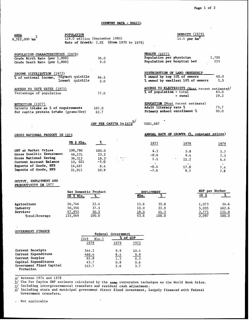
COUNTRY DATA - BRAZIL
AREA POPULATION DENSITY (1979)
8,512,000 km 119.0 million (September 1980) 14.4 per kmRate of Growth: 2.8% (from 1970 to 1979)
POPULATION CHARACTERISTICS (1978) HEALTH (1977)Crude Birth Rate (per 1,000) 36.0 Population per physician 1,700Crude Death Rate (per 1,000) 9.0 Population per hospital bed 253
INCOME DISTRIBUTION (1972) DISTRIBUTION OF LAND OWNERSHIP70 of national income, highest quintile 66.6 % owned by top 10% of owners 45.0
lowest quintile 2.0 % owned by smallest 10% of owners 1.5
ACCESS TO SAFE WATER (1975) ACCESS TO ELECTRICITY (Most recent estimatea/
Percentage of population 77.0 % of population - total 63.0- rural 19.2
NUTRITION (1977) EDUCATION (Most recent estimate)Calorie intake as % of requirements 107.0 Adult literacy rate % 75.7Per capita protein intake (grams/day) 62.7 Primary school enrollment % 90.0
GNP PER CAPITA in1979 US$1,687
GROSS NATIONAL PRODUCT IN 1979 ANNUAL RATE OF GROWTH (%. constant prices)
1977 1978 1979
GNP at Market Prices 198,790 100.0 4.5 5.8 5.7Gross Domestic Investment 46,176 23.2 -0.6 9.4 7-3
Gross National Saving 36,313 18.3 1 11.2 4.4Current Account Balance 10, 021 -5.0 1.1Exports of Goods, NFS 16,697 8.4 -0.4 17.8 7.4
Imports of Goods, NFS 21,915 10.9 -7.6 9.5 7.8
OUTPUT, EMPLOYMENT ANDPRODUCTIVITY IN 1977
Net Domestic Product EMPLOYMENT NDP per WorkerUS $Mln. % Mln. % US$ %
Agriculture 16,746 12.4 15.6 35.8 1,073 34.6Industry 50,350 37.3 10.0 22.9 5,035 162.6Services 67,953 50.3 18.0 41.3 3,775 121.9
Total/Average 135,049 100.0 43.6 100.0 3,097 100.0
GOVERNMENT FINANCEFederal Government
(Cr$ Bln.) % of GDP1979 1979 1972
Current Receipts 544.2 9.9 10.4Current Expenditure 460.4 8.4 9.9Current Surplus 83.8 1.5 0.5Capital Expenditures 43.7 0.8 0.6Government Fixed Capital 145.7 2.6 3.7
Formation
a/ Between 1974 and 1978b/ The Per Capita GNP estimate calculated by the same conversion technique as the World Bank Atlas.c/ Including intergovernmental transfers and residual cash adjustment.d/ Including state and municipal government direct fixed investment, largely financed with Federal
Government transfers.
Not applicable

Page 2 of 2
COUNTRY DATA - BRAZIL
MONEY, CREDIT and PRICES 1975 1976 1977 1978 1979 1980(Billions Cr$ outstanding end period)
Money Supply 157.8 220.6 304.3 428.5 746.6 1,340Bank Credit to Public Sector 22.6 49.8 70.6 117.2 236.4 477.5Bank Credit to Private Sector 297.3 461,3 695.1 1,029 ,4 1 730.4. 2,913,4
(Percentages or Index Numbers)
Money as % of GDP 15.6 14.1 13.1 12.6 13.5 10.7General Price Index (1965-67=100) 613 866 1,236 1,714 2,639 5,542
Annual percentage changes in:General Price Index 27.7 41.3 4207 38.7 54.0 110Bank credit to Public Sector 56.9 120.4 41.8 66.0 101.7 101.9Bank credit to Private Sector 55.2 50.1 50.6 48.1 68.1 95.9
BALANCE OF PAYMENTS MERCHANDISE EXPORTS (AVERAGE 1976-1980)1977 1978 1979 1980 US 2 Mln %
(Millions US$) Coffee (beans + soluble) 2,481 17.6Soybean products 1,565 11.1Sugar 554 4.0Exports of Goods, NFS 13,344 14,025 16,714 21,892 Cacao 378 2.7Imports of Goods, NFS 14,823 16,854 2L,748 26,921 Cotton 22 20.2Resource Gap (deficit -) -1,479 -2,829 -5,034. -5,029 Iron Ore 1,215 8.7Manufactured Goods 5,003 35.6Interest Payments (net) -2,103 -2,694 -4,104 -6,004 All other commodities 2,838 20.1Other Factor Payments (net) -455 -563 -636 -1,296 Total 14,056 100.0Net transfers - 71 17 150
Balance on Current Account -4,037 -6,015 -9,757 -12,179 EXTERNAL DEBT, DECEMBER 31,
Direct Private Foreign 810 1,071 1,505 1,202 US $ MlnInvestment (net)Net MLT Borrowing Public Debt, incl. guaranteed 40,049Disbursement 8,765 14,284 11,658 12,451 Non-Guaranteed Private Debt 16,358Amortization 4,135 5,439 6,536 7,000 Total outstanding & Disbursed 56,407Net Disbursements 4,630 8,845 5,122 5,451
DEBT SERVICE RATIOS for 1979Other Capital (net)
%and capital n.e.i. -773 361 -88 2,027Increase in Reserves (+) 630 4,262 -3,218 -3499 Net Debt Service Ratio- 61.0
Public Debt Service Ratio (gross) 36.6Gross Reserves (end year)-' 7,256 11,894 9,688 6,911
Petroleum Imports a/ 4,081 4,483 6,698 10,210Petroleum Exports a/I 32 46 57 195.
IBRD/IDA LENDING, (July 1, 1980) (Million US $):RATE OF EXCHANGE
IBRD IDAAVERAGE 1979 AVERAGE 1980US $ 1.00 = Cr $26.955 US $ 1.00 = Cr $52.605 Outstanding & Disbursed 2,382Cr $ 1.0b = US $ 0.037 Cr $ 1.00 = US $ 0.190 Undisbursed 2,579
Outstanding incl. Undisbursed 4,961
a Crude and derivatives.b/ Debt Service on both public and private external debt net of interest earned on foreign exchange reserves asa percentage of Exports of Goods and Non-Factor Services.c/ Change in level of reserves differs from reserve change in balance of payments by valua-tion adjustment.
May 1982.

66- 64- 62- 621 O 5'8'L ~JUY1
A M A Z 0 N A S THmiaogc a
Taba~arTab / L.
R 0i E rR L0 A b B IC L C LG IC A L 0 F L ORLO G II AA1AREE~ERvE2 9E!ER..EL.BPAZ1L>QIE
~~~ ~NORTHWESTRGO
E-" PI .-A1rPuOna
VEHO *'~1UKIOEESN
A't C/ A . C n eI CoT ' \ 'sILrRcEI . 'I\,,1\0 50 100 150 200[25*\ho L -5.i0 5010 5
NE CLAA EU~.OTTEA
RO -OO ,. O
Rr'TC \G UCE I7Z= dRE MORENA (
V\. N eT V'*\\ EDTFENE /-AKL/ P ExM\ ~ .' / //o
~ EA tAT iT 1,-.., RoAIN r EAED
J /ni e - - - " L R O Y~TE Z ' / A - \.A N OrB RTE Sk\V A Bei%/a/ ('on
UAJAA NII R A/
LHEN EN 7
124
P,,incIEpe ElWFM'.....REre .* 'ETTEi~ ERCATED
COLOMBIo~l M ,cue E-AE~RsEe' ' ". : ~ -- A K E) E(
\XE, EI ___ Ra t e aedl A Pae RE BIOL G
T E
-R - An~rn-aClanoze bordoy lqRColonalzoud ary INCRA. ''
r/ARGEIIDIA/< VencIE
11N Noon0lPrknU PrA F.,%) 4EDT IndiaE AEreEsJIEea:n
Ecd giol taiongial la62nLa

GLOSSARY OF ACRONYIIS
ASTER-RO Associacao de Assistencia Tecnica e Extensao Rural --
Rondonia(Technical Assistance and Rural Extension Association --
Rondonia)
BB Banco do Brasil(Bank of Brazil)
BASA Banco da Amazonia(Bank of the Amazon)
CEPLAC Comisao Executiva do Plano da Lavoura Cacaueira
(Executive Commission for the Cocoa Development Plan)
CETREMI Centro de Triagem e Encaminhamento do ttigrante
(Migrant Orientation Center)
CIBRAZEtI Companhia Brasileira de Armazenamento(Brazilian Storage Company)
DEMIAT Departamento de Estradas de Rodagem do Estado de Itato
Grosso(HIato Grosso State Roads Department)
DNER Departamento Nlacional de Estradas de Rodagem
(National Highways Department)
EtIATER-MT Empresa de Assistencia Tecnica e Extensao Rural --
Mato Grosso(Technical Assistance and Rural Extension Enterprise --
Mato Grosso)
EtIBRAPA Empresa Brasileira de Pesquisa Agropecuaria
(Brazilian Agricultural Research Enterprise)
FIBGE Fundacao Instituto Brasileiro de Geografia e Estatistica
(Brasilian Institute of Geography and Statistics)
FSESP Fundacao Servico Especial de Saude Publica
(Special Public Health Service)
FUNAI Fundacao Nacional do Indio
(National Indian Foundation)

IBDF Instituto Brasileiro de Desenvolvimento Florestal(Brazilian Institute of Forestry Devc'opment)
INCPA Instituto Nacional de Colonizacao e Reforma Agraria(National Institute for Colonization and Agrarian Reform)
POLAMAZONTIA Programa de Polos Agropecuarios e Agrominerais daAmazonia(Amazon Agricultural and Mineral Poles Program)
POLONOROESTE Programa Integrado de Desenvolvimento do Noroeste doBrasil(Northwest Brazil Integrated Development Program)
PROMAT Programa Especial de Desenvolvimento do Estado deMato Grosso(Special Development Program for the State of Mato Grosso)
SEAC Secretaria de Agricultura e Colonizacao do Territorio deRondonia(Rondonia Territorial Agriculture and Colonization,'ecretariat)
SEMA Servico Especial do Meio Ambiente(Special Secretariat for the Environnent)
SUCAM Superintendencia de Companhas de Saude Publica(Superintendency for Public Health Campaigns)
SUDAM Superintendencia do Desenvolvimento da Amazonia(Superintendency for the Development of Anazonia)
SUDECO Superintendencia do Desenvolvimento da Regiao Centro-Oeste(Superintendency for the Development of the Center-WestRegion)

SUNIARY AND CONCLUSIONS
The Setting
i. The Northwest of Brazil, as officially defined, covers 410,000
square kilometers -- about three-quarters the size of France -- and is com-
prised of the federal territory of Rondonia and part of the state of Mato
Grosso. It forms a part of the legally-defined Amazon region, and is hetero-
geneous in terms of climate, vegetation, agricultural aptitude, and population
density. Until the mid-1960s, the Northwest was practically uninhabited
except for scattered Indian tribes and itinerant rubber-tappers and prospectors.
However, with the completion of a 1,500 kilometer earth road linking the two
major cities of the region, Cuiaba and Porto Velho, a massive wave of migrants
started arriving in search of land and employment opportunities. Today, the
population of the Northwest totals approximately 1.2 million, after growing at
a rate of about 11% per annum during the 1970-80 period.
ii. One of the distinctive characteristics of the Northwest, shared by
few other parts of Amazonia, is the existence of climatic conditions and
soils suitable for agriculture. While the extent and types of soils present
in the Northwest are not fully known, existing farms are situated, by and
large, in relatively fertile areas appropriate for the cultivation of tree
crops such as coffee, cocoa, and rubber. Annual crops are also grown in
these areas, but further research on the agronomics and economics of fertilizer
use, and stronger extension services, are needed before sustained annual
cropping can be recommended as an appropriate form of land use. Mluch less is
known about the agricultural aptitudes of the presently unoccupied areas of
the Northwest, although preliminary surveys have indicated some additional
pockets of relatively fertile soils. Detailed land-use capability surveys,
now underway, are being employed to determine the suitability of these areas
for new settlement projects based on small-scale farms (see para. xiii below).
iii. The possibility of obtaining inexpensive agricultural land has been
the main attraction of the Northwest to the hundreds of thousands of migrants
who have arrived spontaneously over the past decade. As of end-1979, about
24,000 migrant families had been settled in government-sponsored settlement
projects scattered along the Cuiaba-Porto Velho road. Others, probably the
majority, have established squatters' rights on the fringes of the official
settlement areas, or have found temporary employment on the farms of those
already settled or in the rapidly-growing towns of the region.
iv. Official colonization projects, based on 100-hectare lots, are
presently confined to Pondonia. They were started in 1970 and now total
seven. These projects are under the responsibility of the National Institute
for Colonization and Agrarian reform (INCRA), an agency which also has juris-
diction over the disposition of lands within 150 kilometers of an international
boundary and those located within 100 kilometers of any federal road or
highway in Amazonia. As such, INCRA is a key institution responsible for
bringing order to the rapid human occupation of the Northwest. To date, INCRA
has been unable to fully accomodate the huge flow of migrants entering Rondonia.
Though the situation is improving, the provision of land titles to prospective

settlers (an essential element in the settlement process) has lagged, as hasthe provision of necessary physical and social infrastructure and services.As a result, a sense of insecurity and isolation pervades much of the territcand crop losses, for lack of physical access to markets, are high.
v. The Mato Grosso part of the Northwest, like Rondonia, is beingoccupied primarily by migrants from the South and Northeast of Brazil.However, no federally-sponsored settlement schemes have yet been estab-lished in the state and the role of INCRA has been confined to regularizingthe land tenure situation (a process known as "land discrimination") andsetting norms for private colonization projects. The land discriminationprocess is still far from complete in Mato Grosso and the de facto pattern ofland distribution is much more heterogeneous than that of Rondonia. WithinMato Grosso, the area of older settlement north of the city of Caceres has ahigh potential for agricultural development. Here, the size distribution offarms is fairly equitable and the soils and climate permit an economy based oncoffee and rice cultivation. Like the situation in Rondonia, the principalconstraint to further development is the presently inadequate infrastructureand services.
vi. As in other parts of Amazonia, the recent and rapid human occupationof the Northwest has raised concerns about the possible impact of economicdevelopment on the natural environment.and on the indigenous Amerindianpopulation. In regard to the environment, it is increasingly evident that thewet tropical forest ecosystem is among the most complex and fragile on earthand that deforestation can have some very negative effects, including leachingand erosion of the soil and, possibly, changes in the climate. Fortunately,and contrary to the conventional wisdom, relatively little of the Northwesthas been deforested to date--certainly less than 5% of the original forestedarea. However, the potential for environmental degradation exists and ecolo-gists are almost unanimous in their preference for farm systems based on treecrops and/or forestry over those emphasizing annual crops. This view is, byand large, also shared by government authorities, and programs to promote thecultivation of coffee, cocoa, and rubber have already been initiated invarious areas of the Northwest.
vii. The size of the Northwest's Amerindian population is not reliablyknown although estimates run as high as 8,000. It is known, however, that therecent swell of migration to the region has intensified pressures on Indianlands and has increased the transmission of diseases, such as tuberculosis,measles and influenza, to which the indigenous population has little or noimmunity. Though the rights of Indians are protected, in principle, throughthe Brazilian Constitution and implementing legislation, the National IndianFoundation (FUNAI) has, for lack of funds and staff, been unable to preventinvasions of Indian lands or to provide adequate medical care when epidemicshave erupted. In the future, it is inevitable that contacts between settlersand Indians will increase, and FUNAI will need to improve its capacity forameliorating the possible negative effects of such contacts.
Emerging Regional Policy
viii. The further settlement and economic development of the Northwest
is currently one of the high priorities of the federal government. To this
end, a federal Special Program, called the Northwest Brazil Integrated Devel-
opment Program (POLONOROESTE), was established for the region in 1981 and
budgeted at Cr$77.3 billion (about US$1.1 billion equivalent at the end-January
1981 official exchange rate) for the 1981-85 period. In essence, POLONOROESTE
is directed to helping bring order to the large, spontaneous migratory flow
to the Northwest and, consequently, at increasing the productivity, incomes
and social welfare of the region's present and future population. These basic
objectives would be reached through the execution of' a number of integrated
measures. Though the details of specific projects to be financed through
POLONOROESTE are still evolving, the major components of the program may be
generally described.
ix. In order to help resolve the problem of inadequate physical farm-to-
market access (probably the most urgent of the current problems), about 57%
of the total POLONOROESTE budget would be used for the reconstruction and
paving of the Cuiaba-Porto Velho road and the improvement of the secondary
and feeder roads network in the areas of greatest agricultural potential.
These related measures, in themselves, should greatly benefit the region by
lowering the cost, and increasing the accessibility, of inputs (both agricul-
tural and industrial) and by facilitating the evacuation of regional production.
x. It seems clear that improving the regional transport system is a
necessary, though not sufficient, step in the process of promoting the produc-
tive settlement of the Northwest. This point is explicitly recognized in the
POLONOROESTE program proposal (exposicao de motivos) which, in addition to the
construction and improvement of roads, also provides for the consolidation of
existing settlement projects and the establishment of new ones, improvements
in the region's physical and social infrastructure and services (including
land titling), and measures to protect the natural environment and the interests
of the indigenous population.
xi. In regard to the consolidation of existing settlement projects, it
is the intention of the Rondonia government to establish a number of urban
support centers (nucleos urbanos de apoio rural) in the rural areas furthest
removed from the Cuiaba-Porto Velho road. These support centers would make
available to previously isolated settlers a wide range of infrastructure and
services, including technical assistance; credit, storage and marketing
facilities; schools and health posts; communications facilities; and recreation
areas. In addition to the production benefits these centers would bring to
the settlers, they would be instrumental in creating a sense of community -- a
crucial factor in the process of fixing settlers to the land. The role of
INCRA in the existing settlement areas is expected to gradually diminish over
the next few years as preparations are made to transfer existing settlement
projects to the jurisdiction of the territory (which is expected to become a
state in 1981).
- iv -
xii. The major responsibilities of INCRA under POLONOROESTE would be toregularize the region's land tenure situation and to escablish new settlementprojects in presently unoccupied areas. The first responsibility, if carriedout successfully, would significantly reduce the insecurity of many settlerswho do not now possess definitive titles to their land, while increasing theilopportunity to obtain investment credit through the formal banking system.Though the land tenure services of INCRA would be upgraded throughout theNorthwest, high priority would be given to providing definitive titles tosettlers who have already established squatters' rights on the fringes o theexisting settlement projects. This measure would help fix this population tothe land and, hence, take some of the pressure off the new settlement areas.
xiii. The new settlement areas would be initially located in Rondonia(to be extended later to Mato Crosso) along a road now under constructionbetween the towns of Ouro Preto and Costa Marques. It is INCRA's intentionto settle at least 30,000 families in these areas (22,000 in Rondonia and8,nOO in Mato Grosso) over the 1981-85 period. Originally, the new INCRAprojects were to be implanted in the form of square-shaped "modules" measur-ing nine kilometers on a side, with the capacity to settle 120 families eachon 45-hectare lots (supplemented by 3.45-hectare lots for housing and sub-sistence agriculture). While this "module" concept has been retained forplanning purposes, in practice the design of the new settlement projectswould be a function of the agricultural aptitudes of the selected sites andthe socioeconomic characteristics of the expected settler population. INCRAhas commissioned land-use capability and demographic surveys to serve as thebases for subsequent project preparation.
xiv. The specific measures aimed at protecting the natural environ-ment and the interests of the Amerindian population are still being developed.It is expected, however, that POLONOROESTE funds will be mainly used forstrengthening the administrative capacities of the agencies entrusted withthese tasks (the Brazilian Institute for Forestry Development - IBDF andthe Special Secretariat for the Environment - SEMA in the case of environ-mental protection, and FUNTA.I in the case of Indian affairs). In regard tothe environment, institution-building would be directed to improving IBDF'sability to monitor deforestation and to prevent invasions of forest reserves.Funds would also be made available for the financing of new national parks(IBDF) and ecological research stations (SEMA). Likewise, FUNAI would bestrengthened and provided with funds for the demarcation and monitoring ofIndian lands, the contacting of as yet uncontacted tribes, and for improvingits social and production services.
Xv. A forest policy for Amazonia is being developed parallel toPOLONOROESTE, and its implementation should also have a beneficial impact onthe future development of the Northwest. This policy, elaborated by theMinistries of the Interior and Agriculture, in effect calls for the zoning ofAmazonia and the promotion of environmentally-preferred modes (e.g., sustainedlogging operations) of development. It also provides for the monitoring offorest reserves, Indian lands, national parks and other types of land-usezones, and for severe penalties for unauthorized land use within these zones.The implementing legislation for this policy is currently under review by theNational Security Council.

Agricultural Production Forecasts
xvi. In order to better evaluate the agricultural potential of the
Northwest and to assess in a preliminary manner the possible impact of proposed
regional development policies, an attempt was made to project regional agricul-
tural and timber production to 1984, 1989, and 1994. These projections were
made according to two scenarios -- one representing a simple extrapolation of
past trends and the other assuming a full array of government assistance,-much
as proposed under POLONOROESTE. The results of this exercise strongly suggest
that the Northwest has considerable potential in agriculture and forestry and
that the production response to public investments in infrastructure and
services could be both rapid and extensive.
xvii. Under the assumptions of Scenario I (that is, extrapolation of past
trends), total agricultural production could be expected to grow
at a 8% average annual rate over the next 15 years. Though this is in excess
of the historical growth of all Brazilian agriculture of about 5%, the absence
of expanded government activity under this scenario could very well jeopardize
the long-term development of the region in ways (e.g., through an aggravation
of social tensions over issues related to land tenure, and needless environmental
degradation) not fully reflected in the production figures. The clear prefer-
ence, therefore, would be for Scenario II (which assumes a full range of govern-
ment asistance). Under this scenario, not only would production be expected to
grow at a 13% average annual rate (resulting in a level of production which by
1989 would be 2.3 million tons in volume, or US$827 million in value, higher
than would be the case under Scenario I), but indiscriminate land clearing
would be checked, and by good initial land selection, improved land titling
and technical support, there would be a move toward sustained cropping (empha-
sizing tree crops) rather than the short-term exploitation of the land.
Conclusions
xviii. The principal conclusion of the present report is that the Northwest
has the potential to become an important agricultural and timber-producing region
of Brazil, and a place where migrants from other parts of the country may be pro-
ductively and permanently settled on small-scale farms. Thus,the measures pro-.
posed under POLONOROFSTF in support of the future settlement and development of
the region seem justified on both economic and social grounds. Such measures
also seem justified on the grounds that a sizeable population already exists in
the region -- a significant proportion of which now finds itself in insecure
land tenure situations and without access to basic infrastructure and services.
xix. Though the measures contemplated in POLONOROESTE deal with most of
the region's major problem areas, it may also be concluded that the execution
of this program will entail a higher-than-normal degree of risks. Most of
these risks emanate from the basic characteristics of the Northwest: (i) its
huge land area and frontier status; (ii) its rapidly-growing population;
(iii) its confused land tenure situation; (iv) its fragile, and imperfectly-
known, natural environment; (v) its Amerindian population, now in the early
stages of contact with modern society; and (vi) its thin administrative
structure.
- vi -
xx. Perhaps the greatest risk is that the administration of POLONOROESTand those of the executing agencies, may be unable to fully control and monit:the future occupation and development of the Northwest. Thus, the governmentshould be prepared to accept some of the negative effects frequently associatwith accelerated development in frontier areas. Included among these negativceffects are likely to be: (i) continued conflicts over land-related issues,including some invasions of Indian lands; (ii) some indiscriminate deforesta-tion and unsound farming practices; and (iii) instances of general lawlessness.While such effects are to some extent inevitable, they would certainly bemore widespread and serious in the absence of the special measures contemplatedunder POLONOROESTE.

THE INTEGRATED DEVELOPM.NT OFBRAZIL'S NORTHWEST FRONTIER
I. INTRODUCTION
1.01 The Northwest Region of Brazil is officially defined as the area
of influence of the 1,500 kilometer Cuiaba-Porto Velho road. This area
encompasses all of the federal territory of Rondonia, plus 14 municipios
located in the central and western parts of the state of Mato Grosso. In
total, the Northwest covers approximately 410,000 square kilometers, or
slightly less than 5% of the national territory. The 1981 regional popula-
tion, including the municipio of Cuiaba, is estimated to be in the neighborhood
of 1.2 million. While relatively short-lived economic booms (based on gold in
Mato Grosso and on wild rubber in Rondonia) have lured migrants to the region
in the past, most of the present population has arrived since the mid-1960s
-- a period coinciding with the opening of the Cuiaba-Porto Velho road.
Despite this recent growth, however, the average population density is still
less than three inhabitants per square kilometer, and vast areas of forest
remain virtually uninhabited.
1.02 Within Brazil, the Northwest is perceived as a region of rich soils
and great economic potential and, as such, has attracted the attention of both
the public and private sectors in recent years. To the government, the region
is viewed as an important future source of agricultural production for export
and for domestic consumption, as well as a location where migrants from other
parts of Brazil can be productively and permanently settled on small-scale
farms. To private firms and individuals, the region is viewed more in terms
of profits arising from current or potential initiatives in agriculture and
livestock, forestry, mining, light industry, private land development,
and outright land speculation and fraud (grilagem). Though the aims of the
public and private sectors complement each other in many ways, the disorderly
pattern of the region's past occupation makes it imperative that its future
development be closely guided by the government in a manner which promotes
both rational land-use patterns and social equity. If such guidance is not
fortlhcoming, there is a substantial risk of replicating in the Northwest the
highly skewed distribution of income and wealth, chronic migration, and
environmental degradation observed elsewhere in Brazil.
1.03 The desire of the present govertnment to steer the future socio-
economic development of the region in the directions recommended above is
evident from the Northwest Brazil Integrated Development Program (Programa
Integrado de Desenvolvimento do Noroeste do Brasil-POLONOROESTE) first proposed
in 1979 and formally established in 1981. At the core of this program is a
project to reconstruct and pave the Cuiaba-Porto Velho road budgeted at
approximately US$568 million equivalent at the end-January 1981 official
exchange rate, excluding allowances for physical and price contingencies.
However, in order to maximize the economic and social benefits of this improve-
ment in the transport system, the program also calls for the implementation of
parallel projects to promote land settlement, agricultural development, and
feeder roads construction in the main road's area of influence. These parallel
projects, budgeted at around US$520 million, are specifically aimed at improving
the socioeconomic conditions of small-scale farmers already residing in the
area and establishing colonization schemes to accomodate the expected flow of
new immigrants. An additional IJS$36 million is allocated for environmental
protection and for support of Indian communities.

-2-
1.04 In principle, the measures contemplated in the integrated developmenprogram could lead to significantly higher levels of output and employment inthe region, coupled with a socially-acceptable distribution of income andwealth. However, the existence of certain conditioning factors imply that thesuccessful execution of any overall development program for the Northwest willrequire a flexible and creative approach and exceptionally strong centralmanagement. Among the more important of such factors are: (i) the region'sgreat heterogeneity in terms of present levels of development, natural resourceendowments, population densities, structures of land ownership, availabilitiesof physical and social infrastructure and services, and other socioeconomicvariables; (ii) its extremely high rate of population growth based mainly onimmigration; (iii) the rudimentary knowledge of its soils, forests, andpopulation; (iv) its precarious transport system, particularly roads; (v) theundefined land tenure situation prevailing in some areas; (vi) its fragilenatural environment subject to rapid degradation after clearing; (vii) theexistence of an indigenous population subject to threats from new immigrantsover land rights; and (viii) the weak managerial capacities of some potentiallyimportant executing agencies.
1.05 The basic purpose of the present report is to describe the physicaland human environments of the Niorthwest, with a view to assessing this region'spotential and prospects for sustained economic development. Emphasis willbe placed on further describing the aforementioned conditioning factors andon 'analyzing how they influenced in the past, and might influence in thefuture, the design and implementation of public policies, including POLONOROESTE.As implied La the previous paragraph, the available statistical informationl onthe Northwest is limited, often outdated, and of questionable quality -- aproblem which is common to most dynamic frontiers. It was frequently necessaryto choose among several conflicting sources of information or to extrapolatefrom limited field observations. Thus, while the descriptions and analysescontained in the present report are believed to be based on the best informa-tion available, the report's findings may be subject to a wider margin oferror than would be those of studies of less dynamic regions of oldersettlement.
-3-
II. DEVELOPMENT PLANNING FOR THE NTORTHWEST
2.01 The elaboration of plans and the execution of programs for the
development of the Northwest involve a host of agencies at different levels
of government. The development of the Northwest entails benefits (e.g.,
improving the national balance of payments and domestic food supply, providing
settlement areas for poor migrants from other parts of the country, promoting
national integration, etc.) which transcend regional boundaries. At the same
time, subnational governments in the region have neither the financial re-
sources nor the administrative capacities to mount a comprehensive development
effort. For these reasons, the role of the federal government is currently
dominant. The present chapter briefly describes the basic administrative
structure of the Northwest and the federal Special Programs operating in the
region. Recent development plans elaborated by the state of tNato Grosso and
territory of Rondonia will also be described and evaluated. Specific comments
and recommendations pertaining to the major federal, state, and territorial
executing agencies are scattered throughout subsequent chapters.
A. Administrative Structure
Federal
2.02 At the federal level, it is the Ministry of the Interior that
is largely responsible for administering and monitoring regional develop-
ment programs. The federal Secretariat of Planning (SEPLAN), however, also'
plays an important role by setting national planning objectives (which the
regional plans must follow) as well as broad guidelines for public expendi-
tures. In order to decentralize regional development efforts, a number of
regional development agencies, all linked to the Ministry of the Titerior,
have been established over the years and it is the intention of the present
government to further strengthen them. Two of these agencies, the Super-
intendency for the Development of Amazonia (SIJDAM) and the Superintendency for
the Development of the Center-West Region (SUDECO), have overlapping jurisdic-
tions in the Northwest.
2.03 SUJDAM is the principal planning agency for "Legal Amazonia", which,
in addition to Rondonia and Mato Grosso (the Northwest), includes the states
of Para, Amazonas and Acre, the federal territories of Amapa and Roraima,
and parts of the states of Maranhao and Goias. It is headquartered in Belem
and is responsible for elaborating the overall development plans for Amazonia,
for administering fiscal incentive funds in collaboration with the Banco da
Amazonia (BASA), and for administering and monitoring the federal Special
Programs in its jurisdiction. SLIDECO, whose main offices are located in
Brasilia, is in charge of development planning for the Center-West, defined
as the Northwest, plus the states of Mato Grosso do Sul, Goias, and the
Federal District, and for administering and monitoring a number of federal
Special Programs, not under the responsibility of SUDAN. Unlike SUDAM, SUDECO
does not administer fiscal incentive funds.

-4-
Territory, State, and Local
2.04 Parallel to the regional development agencies are the governmentsof the federal territory of Rondonia (with seven municipios) and the state ofMato Grosso (with 14 municipios included in the Northwest region). Rondoniahas been a federal territory since 1943 and is considered a "decentralizedunit" of the federal government, linked to the Ministry of the Interior. Itsgovernor is nominated by the Minister of the Interior and confirmed by thePresident of the Republic. UJntil recently, Rondonia had little financialautonomy and taxes normally in the sphere of the states (principally thevalue-added tax - ICM) were collected by the federal government and returnedto the territory upon the approval (by the Mlinistry of the Interior) of aspending plan. Starting in 1979, however, Rondonia began collecting its owntaxes while gaining a certain degree of autonomy over how the proceeds wouldbe spent. Taxes collected by the territory are supplemented by variousrevenue-sharing arrangements, the most important being the State and Terri-torial Participation Fund which, in recent years, has accounted for aboutone-fourth of Rondonia's total revenues. Municipal government is at anembryonic stage in the territory, but the present administration of Rondoniais seeking to strengthen the local administrative apparatus as part of itspreparations for statehood, expected in 1981.
2.05 The present state of Mato Grosso was established on January 1, 1979when the former state of Mato Grosso was divided into two parts, the southernportion becoming the state of Mato Grosso do Sul. As a result of this division,which left the state with two-thirds of the land area of the former state, butonly one-third of its population and economic activity, Mato Grosso has beenundergoing severe financial difficulties. In addition, the new state of MatoGrosso includes the former capital, Cuiaba, and it has been obliged by stringentcivil service laws to maintain much of the payroll of the old state. In orderto ease this financial problem, a federal Special Development Program for theState of Mato Grosso (PROMAT) was established in 1977 to supplement thestate's budget (see paras. 2.14-2.16 below for mo.e details).
2.06 The strength of local government varies considerably within MatoGrosso. The most developed municipios tend to be located in the area ofolder settlement between Cuiaba and Caceres. In the frontier areas of thestate (i.e., Vila Bela and Aripuana), municipal governments, like thoseof Rondonia, are at an early stage of development and frequently requirefinancial and technical assistance from the state.
B. Federal Special Programs
2.07 Three federal Special Programs are currently directed at the Northwest:PROMAT, POLONOROESTE, and POLAMAZONIA (Amazon Agricultural and Mineral PolesProgram). As mentioned above, the responsibility for the administration andmonitoring of these programs lies with the Ministry of the Interior (throughSUDECO and SUDMA), in collaboration with SEPLAN, other federal ministries, andthe subnational governments involved in the programs' execution. A discussionof these programs' objectives and accomplishments to date follows.

-5-
POLONOROESTE
2.08 POLONOROESTE, formally created in 1981, is Brazil's newest Special
Program and the first specifically designed for the Northwest. Its primary
objective is to promote the orderly human occupation and development of the
tegion through government support of productive activities, and the implantation
of economic and social infrastructure. The reconstruction and paving of the
Northwest's main overland artery (the Cuiaba-Porto Velho road), a key element
of POLONOROESTE, had been considered by the Ministry of Transport as early as
the mid-1970s, but it was not until 1979 that the government officially called
for a program in which highway construction was integrated with agricultural
development and settlement. In this year, Regulation (Portaria) 126, signed
by the Ministers of Interior, Transport, and Agriculture, established an
interministerial working group charged with the task of designing a settlement
strategy for the region, and of proposing specific settlement and infrastruc-
ture projects. The findings of this working group were subsequently issued as
a two-volume report. 1/ Although hastily prepared, this document served to
highlight the problems and potential of the Northwest. It also stimulated a
constructive debate in regard to the approaches that could be taken to bring
order to the region's settlement and agricultural development. A broad
consensus was finally reached on this point and, while the details of specific
projects are still evolving, the main thrust of the interministerial report
now forms the basis of POLONOROESTE.
2.09 According to the program proposal (exposicao de motivos), POLONOROESTE's
principal undertakings during the 1981-85 period are to be: (i) reconstruction
and paving of the Cuiaba-Porto Velho road; (ii) construction and consolidation
of the secondary and feeder roads network; (iii) implantation and consolidation
of settlement projects; (iv) execution of land tenure regularization services;
(v) support of agricultural, forestry and agroindustrial activities and
provision of social services and infrastructure to small rural communities 2/;
and (vi) environmental protection and support of indigenous communities. The
investment budget for POLONOROESTE for the 1981-85 period totals Cr$77.3 billion,
approximately US$1.1 billion at the end-January 1981 official exchange rate.
More than half of this budget would be allocated to the transport sector (see
Table 1). Sources of funds for the entire period have not yet been identified,
but are expected to emanate from the regular budgets of the executing agencies,
allocations from the National Integration Program (PIN), and domestic and
foreign loans (including one or more from the World Bank).
1/ Ministries of Interior, Agriculture, and Transport, Programa Integrado
do Desenvolvimento do Noroeste do Brasil (Brasilia, 1979).
2/ Integrated rural development projects would be implemented in Ariquemes
and Ji-Parana/Cacoal (Rondonia) and Caceres/Mirassol d'Oeste and Tangara
da Serra/Barra do Bugres (Mato Grosso).

-6-
Table 1
POLONOROESTE BUDGET, 1981-85(millions of January 1981 cruzeiros)
Component Cr.$ % of Total
Transport 44,305.3 57.3
- Cuiaba-Porto Velho Road 38,690.0 50.0- Feeder Roads 5,615.3 7.3
Settlement of New Areas 17,813.2 23.0
Land Tenure Services 2,179.3 2.8
Rural Development 9,783.0 12.7
- Arquemes (RO) 2,041.8 2.6- Ji-Parana/Cacoal (RO) 2,463.6 3.2- Caceres/Mirassol d'Oeste (MT) 3,335.6 4.3- Tangara da Serra/Barra do Bugres (MT) 1,942.0 2.5
Environmental Protection 791.1 1.0
Amerindian Affairs 1,646.1 2.1
Administration 790.0 1.0
TOTAL 77,308.0 100.0
Source: POLONOROESTE, ExposiQao de Motivos.

-7-
2.10. At present, the preparation of the agricultural development and
settlement, feeder roads, environmental, and Indian protection components of
POLONOROESTE, though proceeding well, is still incomplete, and the reconstruc-
tion and paving of the Cuiaba-Porto Velho road is only just beginning.
However, the integrated nature of the program, its concentration in an area
with a rapidly growing rural labor force and considerable agricultural poten-
tial, and its explicit concern for the natural environment and the indigenous
population, represent a vast improvement over previous road-building programs
in the Amazon region in which such factors were generally absent.
POLAMAZONIA.
2.11. POLAMAZONIA, created through Decree 74,607 of September 25, 1974,
operates in 15 areas of "Legal Amazonia" selected for their development
potential. Its principal objectives are: (i) the incorporation of regional
resources into the national productive process; (ii) the improved distribution
of income; (iii) the promotion of productive activities oriented toward both
local consumption and export; (iv) the fixing of population through the
creation of employment and improvements in the quality of life; and (v) the
improvement of urban infrastructure. POLAMAZONIA, jointly administered by
SUDAM and SUDECO, effectively began operations in July 1975.
2.12. During the 1975-78 period, Cr$1.l billion in 1978 cruzeiros (US$61
million), or about 14% of POLAMAZONIA's total budget, was allocated to Rondonia.
An additional Cr$478 million (IJS$17 million), 16.3% the program's total
annual budget, went to the territory in 1979. The funds for 1979 were dis-
tributed among 24 projects for physical infrastructure in transport and energy
(47% of the total), health and education (21%), support of agriculture and
industry (20%), and urban development (13%).
2.13. Many of the specific projects receiving POLAMAZONIA funds in Rondonia
in 1979 were also granted resources through this program in previous years.
This was the case, for example, with agricultural research and technical assis-
tance; land tenure services; the construction of grain storage facilities in
Ariquemes, Ouro Preto, Ji-Parana, and Vilhena; support of agroindustrial
projects in Porto Velho and Ji-Parana; and the initial phases of the road
planned to link Costa Marques with Ouro Preto. Other proj-ects, completed during
the 1975-78 period, include: (i) a road from Ariquemes to Rio Machado (in the
cassiterite mining areaO; (ii) improvement of the airports in Porto Velho,
Ji-Parana, and Guajara-Mirim; (iii) the preparation of urban development plans
for Porto Velho, Ariquemes, Ji-Parana, Pimenta BLiono, and Vilhena; (iv) urban
water and sewer projects in Ouro Preto, Cacoal, Jaru, Ariquemes, Presidente
Medici,, and Vilhena; (v) a study of industrial opportunities in the territory;
the installation of a major health facility in Ji-Parana and of smaller health
posts in. Espigao d'Oeste, Riozinho, Ariquemes, Pimenta Bueno, Jaru, Ouro Preto,
President Medici, Cacoal, and Vilhena; and (vii) studies for the implantation of
a hydroelectric project at the Cachoeira Samuel.

PROMAT
2.14. PROIIAT was established through Complementary Law 31 of October 11,1977 at the time of the decision to divide the former state of Mato Grosso.It was to run for ten years, starting in 1979, with an expenditure program tobe elaborated by a special federal commission under the coordination of SUDECO,SUDECO, in turn, contracted the basic studies and the preparation of a six-yearinvestment program (1980-85) for Mato Crosso to the Joao Pinheiro Foundation.
2.15. The principal concerns of the federal government in Mato Grosso, tobe partially dealt with through PROMAT, are the precarious nature of thestate's physical infrastructure, especially energy and transportation, and thecurrent financial crisis described above. The subregions of the state givenpriority for PROMAT funds by the federal government include the area ofinfluence of the Cuiaba-Porto Velho road and secondarily, the Pantanal andthe areas of influence of the Cuiaba-Santarem road (BR-163), and roads BR-158(in the area of Barra do Carcas) and AR-1 (in the private colonization area inthe municipio of Aripuana). It was originally felt that PROMAT funds shouldnot be used in parts of Mato Grosso already encompassed in other federalSpecial Programs, but a decision was subsequently reached to repass Cr$500million of the 1980 budget to POLONOROESTE.
2.16. Owing to a national policy of reducing public expendittures, rela-tively little was accomplished during 1979, PROMAT's first year of operation.The original investment program, which gave emphasis to transportation (26%of the total), urban development (7%) and rural development (3%), could simplynot be carried out for lack of funds. The initial budgetary allocation toMato Grosso of Cr$1.7 billion was first reduced to Cr$1.4 billion and then toCr$450 million. The funds actually received were used exclusively for coveringthe state's current expenditures. In order to make up for the shortfall in1979, a Cr$1.05 billion supplement to the regular PROMAT budget was to beallocated to Mato Grosso in 1980.
C. State Development Plans
2.17. In addition to the Joao Pinheiro investment plan for PROMAT mentione±dabove, there are two other multi-sectoral development planning documents witha state/territory scope. The first of these, the I Plano Geral de CTovernopara o Estado de N4ato Grosso (I PAGEMAT), was prepared for the government ofMato Grosso by CAFEB (Companhia Auxiliar de Empresas Eletricas Brasileiras), agovernment enterprise subordinated to the Mfinistry of Mines and Energy. Thesecond, the I Plano de Desenvolvimento de Rondonia (hereafter I Plano), wasprepared by the Secretariat of Planning of the territory.
I PAGEMAT
2.18. The I PAGEMAT, which covers the period 1980-84, is an attempt todevelop a growth strategy for the new state of Mato Grosso. Throughout thedocument, the Center-West, in general, and Mato Grosso, in particular, areviewed as "natural alternatives" for migration and agricultural expansion.

-9-
The economic growth strategy proposed in the I PAGMAT is a variation of the
primary export-based model, although a degree of industrial processing is
called for in order to maximize value-added locally and, hence, state tax
revenues. Emphasis is given to investments in physical infrastructure,
particularly energy and transportation, with the objective of attracting
private capital to the state. In general, economic growth promoting measures
are given explicit precedence over social development programs.
2.19. The expenditure program proposed in the I PAGEIIAT totals Cr$42
billion in June 1979 cruzeiros (US$1.8 billion) to be disbursed over the
1980-84 period. As implied above, the largest budgetary allocations are to
the transport, energy, and agricultural sectors, accounting for 24%, 20%, and
17%, respectively, of the total. With regard to transportation, the principal
concern of the plan is with the paving of the primary road system (including
the Cuiaba-Porto Velho road) and the implantation of feeder roads (with
first priority given to the Caceres/Barra do Bugres area). In the energy
sector, the I PAGEMAT gives major emphasis to the construction of major
hydroelectric projects near Cuiaba. Finally, in agriculture, the plan recom-
mends that priority be given to the establishment of storage and marketing
facilities, and meat packing plants.
2.20. Most investment would be concentrated in the axis formed by the
cities of Cuiaba, Caceres and Rondonopolis (the latter falling outside of the
POLONOROESTE area). However, the I PAGEMAT is essentially an indicative
document, and the availability of resources to finance the proposed investment
projects would depend on transfers from the federal government, PROMAT funds
and other sources, and, thus, on a process of negotiation between the state
and federal administrations.
T Plano
2.21. The principal objective of the I Plano would be to facilitate the
transformation of Rondonia into a state. In order to accomplish this, the
plan recommends that economic and social development over the 1980-85 period
be based on: (i) balanced population growth through the settlement of
previously unoccupied areas and the development of agricultural and silvi-
cultural activities; (ii) the intensification of mining operations, particularly-
cassiterite; (iii) the establishment of industries for processing regional raw
materials, especially agricultural commodities; and (iv) the development of
urban support centers in rural areas.
2.22. According to the I Plano, present and future migrants should be
productively settled in the territory through the development of a colonization
model which includes the necessary physical and social infrastructure as well
as sufficient lots for those seeking land. It goes on to state that proposed
improvements in the social services should be primarily directed at ex'sting
settlement areas, and that these services should be provided, together with
production services, through urban support centers to be established in the
more isolated parts of the presently occupied official colonization projects.
In short, the basic guideline for settlement would be to provide assistance to
small farmers through the provision of physical infrastruicture and a variety
of services, while taking advantage of, and reinforcing, existing concentrations
of population at all levels of Rondonia's emerging urban hierarchy.

- 10 -
2.23. The I Plano proposes a total budget of Cr$64.4 billion in 1979cruzeiros (US$2.4 billion) between 1980 and 1985 -- an amount substantiallylarger thani the POLONOROESTE budget for the same period. Among the 15 sectorincluded in the expenditure program, the most important are "regional development" (26% of the total), planning and administration (17%), agriculture andfood supply (14%), and transportation (11%). The largest individual expenditu;'items contemplated in the I Plano are: the paving of the Cuiaba-Porto Velhoroad (budgeted at Cr$8.3 billion); general administration of the territory(Cr$6.4 billion); the provision of low-income housing (Cr$6.1 billion); theconstruction of secondary and feeder roads (Cr$5.7 billion); the implantationof a hydroelectric facility at Cachoeira Samuel near Porto Velho (Cr$4.9billion); and colonization and land tenure services (Cr$4.5 billion).
General Observations
2.24. It is evident that the I PAGEMAT and the I Plano were elaborated,for the most part, independently of the interministerial report andPOLONOROESTE. Though most of the investments contemplated in POLONOROESTE(e.g., road construction, settlement schemes, and the provision of otherphysical and social infrastructure and services) are also included in thestate/territory plans, some of the additional concerns of the state andterritorial governments, particularly in regard to energy, urban development,and administration have not been explicitly considered in the new federalspecial program for the region. In subsequent discussions between federaland state/territorial officials it was agreed that POLONOROESTE would beprimarily directed at resolving problems in the rural areas of the region, andthat energy and urban development programs would need to be financed eitherthrough local funds or through other programs of the federal government.
III, POPULATION, MIGRATION AND SOCIAL INDICATORS
A. Population Growth and Spatial Distribution
Total Population Estimates
3.01 Brazil's most recent demographic census was conducted in 1980,but only the preliminary findings, confined to data on total population bymunicipio and sex, have been published so far. However, it is already evidentthat the Northwest was the fastest growing region of the country over thepast decade. The total 1980 regional population, according to the census,was around one million (versus about 350,000 in 1970). This figure exceedsby a significant margin the official inter-censal estimates made by FIBGE(Brazilian Institute of Geography and Statistics) since the latter did nottake adequate account of the extremely high rates of migration to the Northwestbetween 1970-80 (see Table 2 and paras. 3.09-3.19). This agency, for example,predicted a 1980 total population for Rondonia of 172,000 -- a level probablysurpassed by 1975.
3.02 Owing to the proposed reconstruction of the Cuiaba-Porto Velhoroad and associated investments in economic and social infrastructure and
services, plus the continuing lure of inexpensive farmland, it is unlikely
that the migratory flow to the Northwest will abate significantly during
the 1980s. In fact, some official projections suggest that the rate of
migration will actually increase. In this regard, forecasts prepared by
the Interministerial working group for the Northwest (see para. 2.08)
predict a total regional population of 2 million by 1985 and 2.8 million
by 1988.
Population Densities
3.03 Because the Northwest is a frontier area in the process of settle-
ment, its average population density (2.5 inhabitants per km2) continues to be
far lower than the national average (about 14 inhabitants per km2). Moreover,
given the heterogeneous nature of the region in terms of such factors as means
of access, agricultural potential, and land ownership patterns, it is not
surprising that average population densities vary considerably among municipios.
In general, average densities tend to be relatively highest in older urbanized
areas, such as Varzea Grande (113 inhabitants per km2), and in recently
occupied farming areas enjoying relatively easy access. Municipios falling
into the latter category include Mirassol d'Oeste (12.7 inhabitants per km2),
Cacoal (8.4 inhabitants per km2), and Ji-Parana (5.3 inhabitants, per km2). In
contrast, population densities considerably below one inhabitant per square
kilometer may be observed in Aripuana, Vila Bela, and Guajara-Mirim. Though
many factors explain these extremely low population densities, the most
important are difficulty of access, concentrated land ownership and, in the
case of Guajara-Mirim, limited soils suitable for small-scale farming.
- 12 -
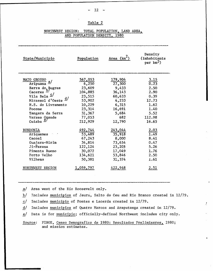
Table 2
NORTHWEST REGION: TOTAL POPULATION, LAND AREA,AND POPULATION DENSITY, 1980
2 DensityState/Municipio Population Area (km ) (inhabitantsper km 2)
MATO GROSSO 567,053 179,904 3.15Aripuana - 6,250 27,300 0.23Barra do bugres 23,609 9,433 2.50Caceres - / 104,885 36,143 2.90Vila Bela - d/ 23,515 60,633 0.39Mirassol d'Oeste - 53,902 4,233 12.73N.S. do Livramento 10,229 6,315 1.62Pocone 23,314 16,691 1.40Tangara da Serra 31,367 5,684 5.52Varzea Gyande 77,053 682 112.98Cuiaba - 212,929 12,790 16.65
RONDONIA 492,744 243,044 2.03Ariquemes 53,489 35,918 1.49Cacoal 67,243 8,000 8.41Guajara-Mirim 34,814 73,654 0.47Ji-Parana 122,124 23,203 5.26Pimenta Bueno 30,072 17,049 1.76Porto Velho 134,621 53,846 2.50Vilhena 50,381 31,374 1.61
NORTHWEST REGION 1,059,797 2.51
a/ Area west of the Rio Roosevelt only.
b/ Includes municipios of Jauru, Salto do Ceu and Rio Branco created in 12/79.c/ Includes municipio of Pontes e Lacerda created in 12/79.d/ Includes municipios of Quatro Marcos and Araputanga created in 12/79.e/ Data is for municipio; officially-defined Northwest includes city only.
Source: FIBGE, Censo Demografico de 1980: Resultados Preliminares, 1980;and mission estimates.

- 13 -
General Growth Patterns, 1960-80
3.04 The most striking demographic characteristic of the Northwest, and
probably the most significant for regional planners, is the extremely high rate
of population growth this region has experienced in recent years, particularly
since 1970. As indicated in Table 3, the region's total population increased
at an average annual rate of 6.5% during the 1960-70 period, and accelerated
to a rate of 10.8% during 1970-80. Population growth during both periods
was thus much greater than could be explained by natural rates of increase
alone. The data also indicate important intraregional variations in the
population growth rate. During the 1960s, Mato Grosso's population grew at
a rate far above that experienced by Rondonia, owing primarily to the rapid
growth of Cuiaba and the municipios of Caceres and Barra do Bugres, the latter
two of which received a large contingent of rural migrants during the decade.
3.05 From 1970 to 1980, the situation described above reversed, with
Rondonia's population growing at the extraordinarily high annual rate of
15.8%, versus the still very substantial 7.8% rate registered in Mato Grosso.
Within M4ato Grosso, the areas of most rapid population growth have been the
Cuiaba-Varzea Grande urban agglomeration and the rural zones to the north,
including the municipios of Aripuana, Barra do Bugres, Caceres, Mirassol
d'Oeste, and Tangara da Serra. In Rondonia, recent demographic expansion has
occurred almost exclusively within the boundaries of the former municipio of
Porto Velho, that is, in or near the official agricultural settlemernt areas
adjacent to the Cuiaba-Porto Velho road.l/
Table 3
NORTHWEST REGION: AVERAGE ANNUAL RATES OF POPULATION GROWTH,
1960-70, 1970-80, 1960-80(%)
State/ Time Period
Territory 1960-70 1970-80 1960-80
Mato Grosso * 7.2 7.8 7.5
Rondonia 4.8 15.8 10.2
Northwest Region 6.5 10.8 8.6
* Includes municipio of Cuiaba and excludes municipio of Aripuana.
Source: FIBGE, Censo Demografico, 1960, 1970 and 1980.
1/ The former municipio of Porto Velho has been recently subdivided into
five new municipios: Ariquemes, Ji-Parana, Cacoal, Pimenta Bueno, and
Vilhena. The latter also occupies a part of the former municipio of
Guajara-Mirim.

- 14 -
Rural-Urban Growth Patterns
3.06 At the time of the 1970 census, the population of the Northwest wasdistributed more or less equally between rural and urban areas, with a slightpredominance of rural population in Mato Grosso (50.9%) and of urban inhabital sin Rondonia (53.6%). Official estimates for 1978 suggest that this urban-ruraLIdemographic balance has remained essentially unchanged, although rural areashave apparently grown somewhat faster than urban centers in northwestern MatoCrosso and in Rondonia. As was the case with rates of population growth,however, significant inter-municipal differences exist with respect to theurban-rural populatiorn distribution.
3.07 The rate of urbanization in the Northwest, like the rate of popula-tion growth generally, has been very rapid, especially since 1970. This maybe observed in the two major urban "poles" of Cuiaba-Varzea Grande and PortoVelho whose populations grew at rates estimated at 6.2% and 12.3% per annum,respectively, during the 1970-78 period. It may be even more readily observedin the smaller cities and towns of Rondonia (e.g., Ariquemes, Ouro Preto,Vilhena, Cacoal) situated adjacent to the Cuiaba-Porto Velho road, whereaverage annual growth rates above 50% are not uncommon. In Mato Grosso,outside of the Cuiaba-Varzea Grande urban agglomeration, the rate of urbani-zation has been considerably lower.
B. Migration
3.08 As implied by the high growth rates discussed above, migration hasbeen responsible for most of the post-1970 demographic expansion of the North-west. Even before this period, however, migration to areas of Mato Grossosuch as Cuiaba and the municipios of Caceres and Barra do Bugres explainedmuch of their population growth. While most migrants to Cuiaba came fromother parts of the state (especially nearby rural areas), those arriving inCaceres and Barra do Bugres generally originated in rural areas of the statesof Minas Gerais, Sao Paulo, and Espirito Santo. The migrants to Caceresand Barra do Bugres were apparently motivated by the availability of inexpen-sive land in state government settlement projects that were being implementedat the time, and often arrived in the region with financial resources derivedfrom the sale of their previous landholdings. Pre-1970 migration to Rondoniaoccurred on a much smaller scale than in Mato Grosso (roughly 25,000 versus100,000). The Northeast and Southeast were the regions of origin for approxi-mately 60% and 20%, respectively, of the total flow.
3.09. Prior to 1970, unlike the more recent situation, the principalmotive for migration to Rondonia was the opportunity for employment in extrac-tive activities such as rubber-tapping and Brazil-nut gathering, and cassiter-ite and gold mining. IWith the improvement of the Cuiaba-Porto Velho roadin 1969 and the rapid spread of information (frequently erroneous) about thehigh quality of soils and wide availability of inexpensive or "free" land inthe area cut by the highway, the flow of migrants to the Northwest, andparticularly to Rondonia, increased sharply. The implantation of a number of

- 15 -
official agricultural settlement projects in Rondonia also tended to reinforce
the attractiveness of the Northwest to potential migrants. In addition to
these "pull" factors, it would appear that several factors acted to "push"
rural workers from the South and Center-West of Brazil. Among the factors
most frequently cited are: (i) agricultural mechanization and a consequent
decline of rural employment opportunities; (ii) sales of smallholdings to
large commercial farmers seeking to expand the production of export crops,
particularly soybeans; (iii) excessive fragmentation of landholdings through
inheritance in regions of earlier small farmer settlement, such as northern
Parana and southern Mato Grosso; (iv) the substitution of agricultural produc-
tion by ranching activities; and (v) periodic climatic problems (especially
frosts) in southern coffee-growing regions.
Size and Time Pattern
3.10 The total size of the migratory flow to the Northwest during the
past decade will not be known precisely until the full results of the 1980
census are published. However, given the estimates of total population
presented earlier, and assuming a 3% per annum rate of natural increase for
the region, the total flow must have been on the order of 500,000 (335,000 to
Rondonia and the balance to Mato Grosso). In regard to the time pattern, one
knowledgeable researcher argues that the flow of migrants to Rondonia has
tended to accelerate since 1974 -- perhaps by coincidence the year in which
the policy of establishing official settlements along the Transamazon highway
was essentially abandoned (see para. 6.03). 1/ As illustrated in Table 4, the
available data on migrants passing through the Migrant Orientation Center
(CETREMI) in Vilhena during the 1976-80 period generally corroborate this
assertion, although one may observe considerable annual variations. 2/ Though
these variations may only reflect deficiencies in the statistical base, some
authorities attribute them to the implementation, and subsequent abandonment,
of a government-sponsored program to discourage migration to Rondonia. 3/
1/ See G. Martine, "Recent Colonization Experiences in Brazil: Expectations
Versus Reality". Paper presented at the Symposium on Internal Migration
and Development, Cuernavaca, Mexico, September 18-21, 1978.
2/ Seasonal variations are also important. In recent years, roughly two-
thirds of the migratory flow has entered Rondonia during the drier
months (April-September).
3/ The data contained in Table 4 greatly understate the total annual flow of
migrants; probably by more than half. This is mainly because CETREMI
only counts those persons declaring themselves to be migrants, and
because young children are excluded from the totals. Moreover, until
very recently, CETREMI only processed migrants entering the territory
during the daylight hours when the facility was open.

- 16 -
Table 4
NUMBER OF PERSONS PROCESSED AT RONDONIAMfIGRANT ORIENTATION CENTER (CETREMI), 1976-80*
1976 17,129
1977 6,319
1978 14,755
1979 44,278
1980 57,572
* Excludes children under 5 years of age.
3.11 This program contained elements of both persuasion and coercion.The first element is best exemplified by the propaganda campaign mounted inlate 1977. The major feature of this campaign was the distribution in thestates of Parana, Mato Grosso, Minas Gerais, and Espirito Santo (areas fromwhich. much of the migration was coming) of pamphlets purporting to describethe potential risks and hardships involved in migrating to Rondonia. 1/ Inaddition to this attempt at persuasion, it is reported that highway policewere employed to force the return of trucks carrying migrants. It is sus-pected, however, that many migrants posing as "tourists" crossed the borderin buses or entered the territory during hours when the control post wasunmanned. 2/
Origin and Destination
3.12 A rough comparison of the migrants' places of birth and previousresidences before arriving in Rondonia can be extracted from the INCRA andCETREMI data. As of early 1977, the INCRA data reveal that about one--thirdof the settlers (colonos) surveyed were born in Minas Gerais, 10% in Bahia,and roughly 5% each in Parana and Ceara. However, the CETREMI data, which aretabulated on the basis of previous residence, convey quite a different picture.According to this source, of those migrants surveyed between August 1977 and.March 1979, about 30% of all family heads had come from Parana, with roughlyan equal percentage last residing in N4ato Grosso. Much smaller numbers ofmigrants had come directly to the territory from Minas Gerais, Espirito Santo,Sao Paulo, and the Northeast.
1/ These pamphlets read as follows: "Pondonia has soils of excellent qualityfor agricultural exploitation. But, for all practical purposes, theselands are already occupied. Therefore, only a limited number of lotsare available for sale. Moreover, a large part of these lands (over 2million hectares) are located either in official colonization projectsor in areas which have been ceded by INCRA, in public auction, to farm-ing and cattle-ranching companies." Cited in G. Martine, op. cit.
2/ See C. Mueller, "Recent Frontier Expansion in Brazil: The Case ofRondonia." Paper presented at the conference on the Development ofAmazonia in Seven Countries, Cambridge, England, September 23-26, 1979.

- 17 -
3.13 The data cited above suggest either that a significant change oc-
curred after 1977 with respect to the migrants' geographical origin, or that
many of the settlers who last resided in Parana and Mato Grosso were born
somewhere in the southeast or northeast of Brazil. While both of these hypo-
theses may be correct to some extent, in all probability the latter accounts
for most of the discrepancies between the two sets of data. This contention
is supported by the findings of a UJniversity of Brasilia study on the Ouro
Preto colonization project. Of the settlers surveyed for this study, roughly
55% were born in Minas Gerais and Espirito Santo, as compared with only 10% in
Parana and Mato Grosso. On the other hand, among those who had lived in
more than one place before arriving in Rondonia, nearly half had resided
in Parana and Mato Grosso, this being especially the case for settlers born
in Minas Gerais and the Northeast. Overall, 71% of the Ouro Preto colonos
had lived in at least two places, and 27% in at least three places, prior
to entering the territory.
3.14 Within Rondonia, migrants have gone primarily to official coloni-
zation areas. Moreover, during the past few years, the overall flow has
become more directed to the central and northern parts of the territory.
During the period from August to October 1977, for example, the principal
destinations were: Colorado (39%), Cacoal (18%), Vilhena (14%), Ji-Parana
(9%), and Ariquemes (8%). During the first three months of 1979, slightly
more than half of the migrants interviewed at the CETREMI post intended to
head for Ariquemes (27%) and Ji-Parana (25%). With respect to Mato Grosso,
the destinations of migrants may be indirectly inferred from the data on the
changes in agricultural employment between 1970 and 1975. On this basis,
one may hypothesize that the most intense inflows occurred in the municipios
of Vila Bela (where the total number of persons employed in agriculture in
1975 was up 300% from the 1970 level, Barra do Bugres (up 265%), Caceres (up
230%), and Cuiaba and Varzea Grande (up 215%).
Age, Sex and Employment Experience of Migrants
3.15 The available data indicate that the migrant population of Rondonia
is predominantly young, male and from an agricultural background. The INCRA
data on settlers in official colonization projects, for example, shows that
about 46% of the population is under 15 years of age, as compared to the
national average in this age bracket of about 42%. This age structure
implies a high dependency ratio and a great potential demand for social
services, particularly health and education. For the overall settler popula-
tion, the male-female ratio is on the order of 1.1. However, the average
rises to 1.3 in the rural areas and falls to 1.0 in urban zones. These ratios
suggest that many males migrate alone and that employment opportunities in the
territory are strongly differentiated by sex.
3.16 Most migrants to Rondonia have come from rural areas and the
principal reported occupation of the family head has been agriculture. Between
March and December 1978, approximately 70% of all migrants interviewed at the
CETREMI post originated in rural areas, although the share of families coming

- 18 -
from urban areas tended to rise during the period. 1/ This latter tendencycontinued in early 1979. During the first quarter of 1979, for example,44% of all migrants entering the territory originated in towns and cities.Paralleling the change in the rural versus urban origins of migrants toRondonia, an increasing percentage of family heads report non-agriculturaloccupational backgrounds. While in 1977 roughly 90% of all household headsgave their occupation as farmers, this share had fallen to about 50% by thefirst quarter of 1979. Throughout the 1977-79 period, the most importantnon-agricultural occupations have been those associated with transportation,construction, domestic activities, and commerce.
3.17 The INCRA data on migrants settled in official colonization projectsreveal that the previous agricultural experience of most has included thecultivation of perennial (unspecified) crops. However, it appears thatrelatively few colonos had made use of rural credit, or had marketed theirproduce through formal channels (e.g., wholesalers, cooperatives, publicagencies) prior to arriving in Rondonia. Table 5 summarizes the availableinformation on these aspects disaggregated by project.
3.18 From Table 5, it may be observed that, on the average, 62% of thesettlers in the official projects had worked with perennial crops in theirplaces of origin. However, considerable inter-project variations in thisaverage are evident; ranging from a high of 84.3% in the case of Rolim deMoura to a low of 41.1% in the case of Sidney Girao. In the projects forwhich data is available, less than one-fourth of the settlers had ever usedrural credit. For those who had, the most frequently cited source was theBanco do Brasil. Finally, the majority of settlers, independent of whetherthey worked with annual or perennial crops, had before coming to the territorymarketed their produce exclusively through intermediaries.
3.19 In sum, the available information for Rondonia suggests that many,if not most, of the recent settlers have come from market-oriented, albeitrelatively low-income, agricultural backgrounds. These data also suggestthe need for a strong extension service to provide advice on agronomic tech-niques (especially those pertaining to tree crops), the use of rural credit,marketing, and cooperative development. Moreover, the actions of this exten-sion service would need to be flexible enough to take into account the widedifferences in agricultural experience among the settlers.
1/ On the basis of a sample of farmers interviewed in 1977 as part of thestate planning secretariat's study on migration, it would appear thatabout 80% of the recent migrants to Mato Grosso originated in rural areas.

- 19 -
Table 5
RONDONIA: PREVT'OUS AGRICULTURAL EXPERIENCE OF SETTLERSIN SELECTED OFFICIAL COLONIZATION AREAS
(% of total household heads)
Perennial Use of InformalProject Crops * Credit Marketing **
Rolim de Moura 84.3 16.0 80.2Ji-Parana 68.9 18.2 67.3Ouro Preto 71.1 48.0 68.6
P. de Assis Ribeiro 50.9 19.9 27.5Sidney Girao 41.1 - 75.9Adolfo Rohl 85.1 - 44.7
MEANi 62.0 23.5 57.5
* Exclusively, or in association with annual crops.
** Exclusive use of intermediaries.
Source: M. H. da Trinidade Henriques, "Diagnostico e Perspectivas para o
Territorio Federal de Rondonia: Demografia" (Brasilia, 1979).
C. Education and Health
3.20 Certain factors complicate the education and health problems of the
Northwest and make them especially difficult to deal with. First of all, the
origins of most of the migrants appear to be extremely humble, and hence they
may be expected to bring with them the poor education and health standards
prevailing in their places of origin. Second, the age structure of the
migratory flow is such that the potential demand for social services, particu-
larly education and health, is unusually high. Third, the process of deforesta-tion and rapid settlement causes changes in the environment which may, in
turn, increase the incidence of certain tropical diseases, especially malaria,
to which the majority of migrants have no resistence. 1/ Fourth, the absence
of an adequate secondary and feeder roads network in the region tends to
isolate the new settlers and thus impede their physical access to education
and health facilities now concentrated in the cities and towns. Fifth, because
of the incipient stage of settlement and agricultural development in many
parts of the region, the extra demand for public education and health services
1/ Moreover, it should be pointed out that the migrants often bring in
diseases (e.g., measles, influenza, tuberculosis) to which the indigenous
population has no resistance (see Chapter IV).

- 20 -
generated by the new migrants is not, in the short run, accompanied by anequivalent increase in the means to finance these services at the local level.Finally, health planning (and to a certain extent education planning) isimpeded by the lack of an adequate statistical base upon which to make deci-sions. With these factors serving as a general background, the followingparagraphs describe the education and health conditions currently prevailingin the region and comment on government programs in these sectors.
Education
3.21 The available evidence shows that recent migrants to Rondonia havebeen, on the whole, very poorly educated. In this respect, INCRA data revealthat over 50% of the family heads in the official colonization projects areilliterate, with the average illiteracy rate rising to almost 70% in the caseof the Adolfo Rohl project. Of those settlers who had received some formaleducation, no more than 2% in any project had graduated from primary school.The educational status of migrants to rural areas of Mato Grosso is also lowbut, on the average, considerably better than that of settlers in Rondonia.Of some 1,000 migrants interviewed in 1977, about 36% of the family heads werefound to be illiterate. Among those with some formal education, 9% hadcompleted four or more years of schooling.
3.22 The large and continuing inflow of migrants and their school-agedchildren has put considerable strain on the region's educational system. Thisis particularly evident in the case of Rondonia where the number of primaryand secondary school students increased by 240% (from 41,148 to 140,311)between 1975 and 1979. Though the number of schools in the territory has alsoincreased rapidly in recent years, as of 1978 about 28% (roughly 32,000persons) of the 7-14 years population cohort was not enrolled in primaryschool. At the secondary level, almost 90% (about 34,000 persons) of theeligible population (15-18 years) was not enrolled in school. In MatoGrosso, the rates of non-attendance at the primary and secondary levelq.in 1977 were 25% (29,000 persons) and 58% (20,000 persons), respectively.
3.23 In Rondonia, the most serious deficiencies in the educationalsystem are found in the rural parts of new settlement areas. Here the chiefproblems are lack of physical access to the formal educational system,which tends to be concentrated in the towns and cities, and the inabilityto attract qualified teachers. In response to these problems, settlers inRondonia have constructed a large number of "provisional" schools on the basisof self-help arrangements and have staffed them with members of the localcommunity. Though these grass roots efforts are commendable, they areclearly inadequate. As of 1978, there was a shortage of almost 900 classroomsin the territory. Moreover, in 1979 only 17 of the 1,257 teachers in the ruralareas (1.3% versus 61% in urban areas) of the territory were officiallyqualified (habilitados). However, a teacher training facility is now operatingin Ji-Parana and others are expected to be established in the near future. Itremains to be seen, though, whether, once trained, these teachers will returnto the rural areas where salaries and living conditions are generally thepoorest.

- 21 -
3.24 Though the available information is sketchy, it would appear that
the problems of rural education in Mato Grosso are similar to those observed
in Rondonia -- deficient infrastructure, poorly-trained teachers, and limited
physical access. In regard to the first; aspect, official statistics for 1977
show a deficit of around 700 classrooms for the entiXe survey area. Unfortu-
nately, the statistics do not allow a spatial disaggregation of this deficit,
but it must be presumed that a major proportion is accounted for by rural
areas. Likewise, the statistics do not permit a urban-rural breakdown of
teachers' qualifications. However, in municipios characterized by recent
occupation, such as Aripuana and Vila Bela, less than half of the primary
school teachers have themselves completed a primary education. This may be
compared to the situation in the older urbanized areas of Cuiaba and Varzea
Grande where 95% of the primary school teachers have a secondary level or
higher education.
3.25 In the short-run, it will be extremely difficult to substantially
improve the rural education system of Mato Grosso given the current financial
problems of the state and the municipios, the latter responsible for rural
education. However, some stop-gap measures, such as the state paying teachers'
salaries in the poorer municipios, and sub-contracting educational services to
private colonization companies located in the far north, are now in effect.
In additicn, state authorities look with favor on a new rule which obliges
cattle ranches receiving fiscal incentive funds to provide primary schooling
to the children of their employees.
Health
3.26 The dearth of health statistics for the Northwest makes it virtually
impossible to evaluate current conditions precisely. Owing to the isolation
of much of the population, deficient infrastructure, and poor diagnostic
capabilities, both births and deaths tend to be under-recorded. Thus, tradi-
tional measures of health conditions such as life expectancies and infant
mortality rates are either not available or of questionable reliability.
Still, the available evidence suggests that regional health conditions are
generally poor.
3.27 In Rondonia, the part of the region for which health statistics
are most complete, the average infant mortality rate in 1978 was on the order
of 137 per 1,000 live births; a rate 40-50% higher than the national average.
Within the territory, the infant mortality rate ranged from a "low" of 84 in
the municipio of Guajara-Mirim to an extraordinarily high 414 in Ji-Pare aa
According to the Rondonia health secretariat, the most common transmissible
diseases in the territory are malaria, leishmaniasis, measles, and whooping
cough; the most frequent causes of death (1977-78) are malaria, hepatitis,
tuberculosis, and measles. 1/ Work accidents associated with land clearing
are also cited as a major health problem.
1/ In 1977 the leading causes of death in Mato Grosso were infectious and
parasitic diseases, respiratory ailments, and anemia. No further
details are available.

- 23 -
3.31 In Rondonia, general public health services are coordinated by
the territorial secretariat of health. 1/ However, in the towns along the
Cuiaba-Porto Velho road (from Ariquemes south) these services have been
sub-contracted to the federal Foundation for Public Health Services (FSESP).
As of 1979, FSESP operated nine health facilities of various levels of
complexity in the territory, and four others were under construction. This
agency has also implanted five urban water supply systems. The state of Mato
Grosso has raised the possibility of entering into a similar agreement with
FSESP to provide health services in the southern portion of the Cuiaba-Porto
Velho road, but this has not yet been finalized. Though the services of
FSESP are generally of high quality, the problem of delivering health care to
the rural population remains unresolved because this agency's facilities and
manpower are concentrated in urban areas. However, it is expected that the
current plan of the Rondonia government to establish urban support centers
(nucleos urbanos de apoio rural) away from the main road should ameliorate
the situation considerably. As currently envisaged, these support centers
would contain not only health posts, but schools as well (see Chapter VI,
paras. 6.29-6.30 for more details)
IV. AMERINDIANS
4.01 Since the colonial period, Brazil's Amerindian population has fallen
from an estimated two to five million to a present-day population of less than
200,000. This dramatic decline (which is similar to that of other lowland
South American Indians) has been the result of a combination of factors,
including eaTly slave raiding expeditions, exposure to disease, and intermar-
riage. More recently, the progressive occupation and economic development of
Amazonia has placed the Amerindian population in an increasingly precarious
position. Diseases transmitted by new settlers have decimated whole tribes
and illegal seizures of Indian lands have reduced the area available for
traditional hunting, fishing and agricultural activities.
A. Legislation
4.02 The indigenous population of Brazil has its status and rights
defined in a body of legislation comprised of Article 198 of the Constitution
of 1969, the Indian Statute of 1973 (Law No. 6,001), and a series of laws and
decrees enacted between 1967 and 1980 which established and now govern FINAI.
This legislation was designed to assure the survival of the Indian population,
regulate the contact and interaction of this population with the larger
national community, and to provide adequate time for the acculturation of
the Indian society to the modern world.
4.03 The most important parts of the legislation are the guarantees
regarding Indian land rights. Prior to the 1969 Constitution, Indians
were considered to own the lands they inhabited. Article 198 of the 1969
Constitution modified this precept. It guarantees to Indians the inalienable
right to the use of the lands they inhabit, but grants ownership to the Union.
1/ The provision of health care services to the indigenous population
is the responsibility of FUNAI. The nature of these services is
discussed in Chapter IV.

- 24 -
4.04 The Indian Statute protects native lands from illegal trespassand gives FUNAI the right to call on the armed forces and on the federalpolice for enforcement of this law. It also states that squatters' rightsdo not apply to Indian lands. According to the Indian Statute, interventionwithin native lands is permitted through presidential decrees, but only underthe following conditions: (i) to put an end to fighting between tribalgroups; (ii) to combat serious outbreaks of epidemics that may lead to exter-mination of the native community or any disease that may endanger the integrityof the forest dwellers or tribal group; (iii) for the sake of national security;(iv) to carry out public works of interest to national development; (v) torepress encroachments upon Indian lands; or (vi) to work valuable subsoildeposits of outstanding interest for national security and development.If, for any of the above reasons, a tribal aroup must be removed to anotherarea, the native community is to be assigned an area equivalent, in allrespects, to the former one.
4.05 The Indian Statute thus clearly provides for the maintenance and pro-tection of native lands and the right to the natural wealth thereon, with thequalifications stated. These qualifications can, and in some cases have,reduced the force of the legal guarantees provided in the Indian legislation.Nevertheless, it is important to note that the main thrust of the legislationis to provide for protection of the rights of the Indian population in wayswhich duly recognize their cultural distinctness and their need, given theirexisting economic systems, for large areas of land.
B. The National Indian Foundation (FUNAI)
Historical Background
4.06 The Indian Protection Service (SPI) was created in 1910 by Colonel(later MarsP'al) Candido Mariano da Silva Rondon, and under his guidanceguaranteed protection for the Indians in their own territory, prohibitedfamilial disruption, and assured each Indian equal citizenship rights withother Brazilians, In its later years, the SPI strayed from its foundingprinciples. By 1967, widespread corruption within the SPI was revealed in theproceedings of a special investigation commission (known as the Figueiredoreport) and the organization was disbanded. Of a total 700 employees in theSPI, 238 were dismissed and 134 were charged formally with crimes.
4.07 A new agency, FUINAI, was then established to deal with the problemsof the Amerindian in Brazil. 1/ Since 1970, the growing emphasis on the devel-opment of the Brazilian Amazon--evidenced by the creation of PIN with itsambitious sub-programs of highway construction, mineral and other naturalresource surveys, and agricultural development; the SUDAM fiscal incentive
1/ It should be noted, however, that the legislation creating FUNAI specific-ally stipulated that personnel previously serving the SPI would automa-tically be employed by FUNAI, with Lhe exception of those who weredismissed for misconduct.

- 25 -
program; and official and spontaneous settlement--has intensified the press-
ures on Indian lands. In principle, this has made the role of FUNAI as
a mediator between "developmentalists" and "protectionists" increasingly
important.
Administrative Structure
4.08 FUMAI is administratively linked to the Ministry of the Interior,
like the territorial governments, SUDAM and SUDECO. Its objectives sometimes
conflict with those of the other, more economic development oriented, insti-
tutions. 1/ For this reason, it often has been suggested that FINAI be removed
from the Ministry of the Interior and placed instead in the office of the
President of the Republic. There is no indication, however, that such a step
is under serious consideration by the Government.
4.09 FUNAI maintains a large administrative headquarters in Brasilia,
which is responsible for coordinating and overseeing the work of 13 regional
delegations. The Presidency, Administrative Superintendency, Planning
Advisory Unit (ASPLAN), and operational divisions are all located in Brasilia
(see Figure 1). Regional delegations and local Indian posts are subordinated
to the Department of General Operations, which is also responsible for executing
the various programs designed by the Community Planning Department and ASPLAN.
The Indian Patrimony Department is responsible for commercial activities
involving Indian lands, resources, or production (including handicrafts).
4.10 Direct, daily contact with the indigenous population mainly takes
place at the local Indian posts. The area, population, and number of villages
attended by these posts varies considerably, sometimes encompassing a large
area with a dispersed population. During the early 1970s, Indian post managers
were given a training course organized by the education division with lectures
on basic anthropology, medical care, accounting, and other relevant subjects.
This training was discontinued in the late 1970s for lack of funds.
4.11 In principle, each Indian post is equipped with a medical dispensary.
In practice, not all of them are. However, some regional delegations maintain
mobile health teams (equipes volantes de saude) staffed by a doctor, dentist,
nurse, and laboratory technician. These teams carry out routine inspection
missions and emergency missions (e.g., for the control of an epidemic).
Mobile health teams generally service operate only in the area of their
respective regional delegations, but in emergency cases they may be called
upon to assist other delegations. Transport for the medical teams is pro-
vided by FUNAI, which employs boats, small aircraft and, in emergencies, an
air taxi service.
1/ In order to minimize possible conflicts of this nature, the government
has recently decided to place a representative of FUNAI on the Delibera-
tive Councils of SUDAM and SUMECO.

- 26 6
FIGURE 1
FUNAI: Present Organization
Supervisory Council Pres dent Indian Council
Secretariat |Technical Administrative Dept
Legal ------ Auditing
Accounting
Administrative-Planning AdvisorySuperintendent Group (AS PLAN)
General Indian General CommunityAdministration Patrimony Operations Planning
RegionalOrganization
Field Staff
IndianPosts

- 27 -
Funding
4.12 FUNAI depends on a number of revenue sources for financing its
activities. The most important source, however, is the annual allocation
from the national budget (see Table 6). This source is followed in impor-
tance by allocationrs from the FAS (Social Assistance Fund) and PIN/PROTERRA.
Funds generated by FUATI itself, largely through the sale of Indian artifacts,
are relatively insignificant. In 1979, FIUAI was budgeted at slightly less
than US$17.5 million equivalent, of which over half was used for administration.
Table 6
FIJNAI Budget, 1979
Sources % of Total Uses % of Total
National Budget 57 General Administration 56
FAS 23 Community Development 17
PIN/PROTFRPA 10 Community Assistance 14
F UAI 3 Demarcation of Lands 6
Other 7 Other 7
Source: FIJNAI
4.13 A serious problem in the history of FUNAI has been the chronic
shortage of funds which has forced the postpo-nement or cancellation of impor-
tant programs, including the demarcation of Indian lands and the training
provided to Indian post managers (see para. 4.10). There are indications,
however, that this situation is changing. First, the government has recently
announced a new program to accelerate the pace of demarcation (see para 4.23).
Second, the allocation to FUNAI in the final POLONOROFSTE budget is substan-
tially higher, in both absolute and relative terms, than it was in earlier
drafts (i.e.,Cr.$1.6 billion out of a Cr.$77 billion total,versus Cr.$500
million out of Cr.$59 billion).
Management Style
4.14 Although FUNAI operates through a three-tier hierarchy (i.e.,
national, regional and local), planning and decision-making functions tend
to be centralized in Brasilia. One result is that programs and projects
elaborated at the national level do not always accurately reflect the local
situation and the self-perceived needs of the Indians. Another result is
that actions to be taken at the local level are often delayed as requests
for authorizations of various types work their way up through the bureaucracy.

- 28 -
These related problems stiggest the need for more frequent and open communi-cation between the three administrative levels of FJNAI, and the delegationof more decision-making authority to the regional and local levels. FUNAIis aware of the need to streamline its operations and to make its programsmore responsive to local needs and is now reviewing possible administrativereforms directed to these ends (see paras 4.16 and 4.17).
4.15 A lack of continuity in management has compounded the problemsdescribed above. FINAI has had three different presidents in the past threeyears, and top managerial posts have changed with each change in the pres-idency. As a consequence, many senior administrators (commonly retiredmilitary officers) have little knowledge of, and experience with, Indianaffairs and are not always able to anticipate problems of concern to FUNAI.This factor has tended to reduce the effectiveness of FUNAI and has increasedthe chances for friction between decision-makers on the one hand and pro-fessional "Indianists" (both government and non-government) on the other.One way in which to improve this situation would be to establish a careerservice through which Indian specialists could move into senior operationalpositions.
Proposed Administrative Reforms
4.16 In late 1979 President Figueiredo issued a decree authorizing therestructuring of FIJNAI to bring greater order and efficiency to its adminis-tration. There are ongoing discussions concerning the kinds of changes to bemade, but as yet no specific structure has been decided upon. Some of theproposals which have been made (not mutually exclusive) include: (i) readjust-ing the boundaries of the regional delegations to conform to political-administrative boundaries; (ii) changing, the administrative superintendentinto an executive director who would assume responsibility for general opera-tions as well as for community planning; and, (iii) decentralizing FUNAI'soperational responsibility, to allow greater autonomy at the regional level.
4.17 The proposed decentralization of FUNAI (item iii above) has metwith criticism from private pro-Indian organizations such as CIMI (theMlissionary Indian Council) and the Comissoes Pro-Indio. They believe that thiswould give local and state political and economic interests greater influencein FUNAI activities, and that the developmentalist attitude of these interestswill lead to areater infringements of Indian rights. 1/ Advocates of decen-tralization within FUNAI, however, feel that the regional delegate needs toexercise a greater influence on the society in his area. The regional delegatewould, in his expanded role, participate in the process of sensitizing localpoliticians and social groups to the needs and problems faced by the Indians.This greater awareness of the community would, it is believed, make FITNAI'soperations easier in the future. In order to prevent the application of localpolitical pressures on the regional delegate, proper and consistent normswould be established as a guide to his activity. This would entail defininosome difficult issues, suclh as what Lype of action is appropriate for atribe or tribes at various stages of accutlturation.
1/ Most disputes with FUNAI concern land, and regional delegates subjectto local influence might be encouraged to hasten the "emancipation"of an area in order to shift reserve boundaries.

- 29
C. Identification and Protection of Indian Lands
4.18 The demarcation of Indian lands, in a way which is clear and
unmistakable, is essential to ensuring the protection of Indian territory.
The recent migration into frontier areas such as the Northwest, and the
disorganized pattern of settlement, has made demarcation one of the most
critical issues for the Indian population. Protection of Indian lands is
necessary in order to provide Indian groups with the continued ability to
maintain their subsistence while they adjust and adapt to the modern world,
and to shield them from the initial shock of contact with the expanding
Brazilian economy.
4.19 The existing legislation provides that prior to the establishment
of any project in the national territory, the responsible individual or
corporation must receive from FUNAI a "negative certificate" (certidao
negativa) which essentially states that no Amerindian groups are present
in the area of the proposed project. In most cases, presentation of a negative
certificate is required by banks prior to making a loan. If it is established
that there are no Indians in the area, then no further action by FUNAI is
necessary after the negative certificate is issued. If not, however, FUNAI
must take measures to demarcate and protect the Indian area.
FUNAI Procedures for Demarcation
4.20 The first step, after the presence of an Indian group has been
verified, is to declare an area "interdicted". This is an administrative
measure which prohibits the entrance of anyone, with the exception of FUNAI
staff, into an area believed to be inhabited by Indians. The boundaries
of the interdicted areas are only approximate, however, and little or no
monitoring is possible with FTNAI's small field staff. At the same time
an area is interdicted, a FUNAI "pacification" mission is sent into the field.
The objective of this mission is to make initial contact with the Indian
group in order to determine its size, origins, traditional territory and
language. Once the group is contacted, a team is left behind to evaluate the
needs of the tribe for land, based upon the types of land use and economic
activity, as well as factors such as religious or other traditions.
4.21 After an Indian group is contacted -- a process which can require
as little as a month, but may last a period of years -- FUNAI can begin
to identify the range of the Indian group. The second step taken is to
"delimit" the area, based on information gathered in field work with the
Indians. Delimitation is done on a map and, once determined, serves as the
basis for a presidential decree, or a regulation of the president of FUNAI,
granting to the Indians rights over those lands contained within the delineated
boundaries.
4.22 The third and final step is the actual "demarcation" of lands at
the ground level and registration of the Indians' legal right to the land in
the Federal Register. According to FUNAI norms, demarcation requires the
clearing and maintenance of a six-meter swath of land around the reservation,
the marRing of the boundary lines with surveyors' markers, and the placing of

- 30 -
concrete posts every 1,000 meters. Alumunium signs are also to be posted atregular five kilometer intervals. Demarcation is generally contracted outto private firms through the General Operations Department in Brasilia. Thecost per kilometer demarcated is estimated at Cr$42,000 in May 1980 cruzeiros(about US$830).
4.23 Discussions with Indian post managers and regional delegates indicatethat the first and most important step to take with respect to protection ofthe rights of Indians to their land is to demarcate and monitor borders ofreservations. The common wisdom is that this would discourage a good deal ofthe illegal trespassing taking place in the region which many people believeoccurs out of ignorance. Initially, the deadline for the demarcation ofall Indian lands was December 1978. Owing to budgetary constraints, thisdeadline was not met. Recently, in the wake of two well-publicized violentclashes between Indians and settlers, the Government has announced that thepace of demarcation would be accelerated. Priority would be given to demar-cating areas where Indian-settler relationships are most tense. 1/
Posseiros vs. Indians
4.24 As implied above, a recurring, and difficult, problem for FUNAIhas been the presence of squatters (posseiros) and other intruders (e.g.,prospecters, hunters, rubber-tappers) within the boundaries of Indian re-serves. 2/ Squatters are subject to arrest and have no claim to compensationfor improvements made on Indian lands if they arrived after the land wasdeclared a reserve. FUNAI feels that if such compensation were offered, itwould encourage land invasion by squatters whose major objective would be thecompensation. However, if it is determined that a squatter was present beforethe establishment of a reserve, he is entitled to some compensation. This isdone on the assumption that, prior to the detection of Indians, there were norestrictions on ownership of the land. In the case of those who have receivedtitle to lands which are later declared a reserve, compensation is mandatory.
4.25 One continuing problem for FUNAI has been the removal of squattersfrom Indian lands. FUNAI, with the aid of the police, has the power to removethe settlers, but cannot resettle them elsewhere, as this is the responsi-bility of INCRA. There are often considerable delays because of the failureof the two agencies to coordinate their activities, and much may depend uponthe personal relationship of the administrators involved. However, draftlegislation is now being considered which would, if enacte-d, establishnorms and assign responsibility to the relevant agencies for the removal andsubsequent resettlement of squatters.
1/ In such troubled areas, the government has recently decided to entrustthe engineering aspects of demarcation to the Army Construction Battalions.
2/ FUNAI uses a variety of (as many as eight) classifications for Indianlands. However, the distinctions are not clearly defined. The basiccategories are a "reserve" (an area set aside for one tribe) and a"park" (an area for several tribes).
- 31 -
D. The Situation of the Indians in the Northwest
4.26 It is, at present, difficult to describe accurately the situation
of the Indians in the Northwest for two reasons. First, information sources
(FUNAI, anthropologists, publications, etc.) disagree in their presentation
of the facts, and there is no complete central source of information. Second,
because settlement of the area has been relatively recent, contacts with
hitherto uncontacted Indian tribes are still being made. The data on the
number and location of the Northwest's Indian population presented below
should be considered in this light.
4.27 The indigenous population of the Northwest located in official
Indian areas (i.e., demarcated, delimited or interdicted tracts) is estimated
to be in the neighborhood of 4,600 (see Table 7) 1/. These Indians occupy an
area totalling about 5.3 million hectares, of which 1.6 million hectares (30%
of the total) have been demarcated. There are more than 20 different tribal
groups though some may be related as evidenced by certain language affinities.
These tribal groups are attended, in principle, by a FUNAI network of 24
Indian posts. However, according to FINAI only 12 of the posts are presently
manned by Indian agents (chefes de posto). The ability of the FUNAI agent to
assist the population under his jurisdiction varies according to local access
conditions. In many cases, the agent can assist only those Indians who seek
him out.
4.28 The smallest tribal group in the Northwest, the Jaboti of northeastern
Rondonia, has only ten members, while the largest, the Cinta Larga (also in
northeastern Rondonia) has 1,750. The population of the Uru-Eu-Wau-Wau group
is unknown in as much as initial contact has been only recently established.
Some of the tribes, regardless of their total size, are subdivided into smaller
groups, and are present in a number of reservations. For example, Indian bands
known as the Nambikwara are found in seven reservations, and the Pareci in
five. Thus, an Indian agent in a particular post may sometimes assist a number
of groups each with a different culture and social organization.
Northeastern Rondonia
4.29 The Indian groups in northeastern Rondonia were contacted only
recently (about ten years ago), or are completely isolated. Much of the
contact was due to the expansion of the agricultural and mining frontier,
as a result of the rapid and intense migration of small-scale farmers and
prospectors from the South.
4.30 Two areas have been interdicted in northeastern Rondonia. To the
southeast of Ariquemes, 878,000 hectares were interdicted in late 1979 for the
Uru-Eu-Wau-Wau. Their presence was discovered when a small group of these
Indians clashed with a family of colonists on the outskirts of an INCRA
1/ The total indigenous population of the Northwest may reach 8,000 if one
includes uncontacted groups and contacted groups for whom an official
area has not yet been designated.

32 -
Table 7
NORTHWEST REGION: POPULATION, SIZE, AND STATUS OF OFFICIAL INDIAN AREAS
Population Size (ha. 10 ) Status
RONDONIA 2,540 2,841.1
Roosevelt 191 233.1 DemarcatedRibeirao 79 47.9 DemarcatedLage 175 107.3 DemarcatedLourdes 446 185.5 DemarcatedRio Guapore 131 69.8 DemarcatedRio Negro Ocaia 193 104.1 DemarcatedPacaas Novas 463 279.9 DemarcatedSete de Setembro 165 247.9 DemarcatedKaritiana 80 89.7 DemarcatedRio Branco 206 n.a. DemarcatedPanorama n-n. 205.0 DelimitedLinha 14 /1 n.a. DemarcatedTubaroes-Massaca 106 200.0 InterdictedKaxarari 109 83.0 DelimitedUru-eu-wau-wau n.a. 878.0 InterdictedSerra Morena 125 110.0 Demarcated
MATO GROSSO 2,260 2,484.0 -
Negarote 31 12.3 DemarcatedSantana 184 6.3 DemarcatedBakairi 262 50.0 DemarcatedUmutina 117 24.6 DemarcatedSarare 35 69.3 DelimitedNambikwara 165 912.0 DelimitedWasusu 39 14.3 DemarcatedAlantesu 30 10.8 DemarcatedHahaintesu 56 28.3 DemarcatedMamainde 58 63.4 DelimitedSaluma 123 640.0 InterdictedIrantxe 122 58.0 DelimitedPareci 806 556.0 DelimitedBrito 10 1.9 DelimitedFigueira 14 16.2 DelimitedFormoso 30 20.5 Delimited
TOTAL 4,622 5,325.1
Source: FUNAI, Projeto de Apoio as Communidades Indigenas da Area de Influencia daRodovia Cuiaba/Porto Velho, 1980-85 (Brasilia, September 1980); mission estimates.

- 33 -
settlement project. A "pacification" team has been in the field since January
1980 and face-to-face contact has been recently established. Since INCCRA is
planning to implant a number of new settlement projects in areas near to where
the IJru-eu-Wau-Wau are located, it is particularly urgent that traditional
Indian lands be delimited and preventive medical care provided. Another
200,000 hectares have been interdicted for the Tubaroes-Massaca Indians and
it is expected that this area will be demarcated by the end of 1981.
4.31 Because the interdicted areas are so large, it has been very diffi-
cult to monitor their borders. However, because the Indian groups are thought
to be aggressive, squatters have avoided entering the interdicted lands. Of
the remaining groups, six in the Rio Branco post have no area reserved. The
Arara, Gaviao, Digint, Surui, Pareci and Cinta Larga all have lands demarcated
by FUNAI, which includes the Aripuana park. The Aripuana park itself strad-
dles the border of Rondonia and N4ato Grosso, and its size is on the order of
1.5 million hectares.
4.32 Despite the demarcation of most of the Indian lands in northeastern
Rondonia squatters remain within Indian reserves. The most visible case is
the Sete de Setembro reserve, where approximately 90 squatter families (who
arrived after the reserve was demarcated) have been identified. The Government
has recently begun to move some of these families elsewhere, and it is now
thought that there are 50-60 families remaining.
Northwestern Rondonia
4.33 The administrative unit of FUNAI responsible for Indians in north-
western Rondonia is the Ajudancia de Guajara Mirim,. Some of the groups in
this area have been in contact with the national society for almost 20 years,
as is the case with the largest, the Pacaas-NTovos. In some cases, Indians
have adopted the way of life of rubber-tappers, with correspondingly poor
socioeconomic situations. Flowever, a commtnity development project, based
on rubber-gathering, has eliminated the middleman and now allows the Indians
to trade on their own. The Indians of northwestern Rondonia are generally
considered to be in a period of "demographic recovery". That is, their popu-
lations are recovering from the shocks of disease and armed conflict with
rubber-tappers and settlers during the early period of contact. MIost groups
remain near the various Indian posts in the area.
4.34 The land situation is relatively tranquil in northwestern Rondonia.
Almost all of the areas have been demarcated. However, official FIUNAI sources
disagree on the status of the Rio Guapore post. One source claims it is
demarcated but another claims demarcation was halted when the firm which had
been contracted went bankrupt. This has affected the NTakurap, Jaboti, Kanoe,
and Tupari, some of which are beyond the access of the post agent. The
Kaxarari and Panorama reserves must also be demarcated.

- 34 -
Mato Crosso
4.35 Most of the Indians in the portion of Mato Grosso in the areaof influence of the Cuiaba-Porto Velho road are at relatively advanced stagesof acculturation. In fact, some groups engage in mechanized agricultureand maintain commercial relationships with the n-ational society. The Salumaand Menku are exceptions to this as they were contacted as late as 1974.
4.36 As elsewhere in the Northwest, the most important issues in MatoGrosso are related to land rights. Perhaps the most well-known case inpoint involves the Nambikwara bands of the Guapore Valley. These bands,who once controlled almost one million hectares, are today in possessionof six small reserves totalling less than 200,000 hectares (of which lessthan 60,000 hectares have been demarcated). 1/ Since a new 203 kilometerstretch of the Cuiaba-Porto Velho road is expected to cut through the GuaporeValley in the near future, it is most urgent that demarcation of Nambikwaraareas be completed in order that fuirtlher encroachments on Indian lands maybe avoided. Other major priorities for Mato Grosso include completing theredefinition and demarcation of the Pareci area and the demarcation of theTrantxe, Saluma, Brito, Figueira and Formoso areas.
F. The FUNAI Program for the Northwest
4.37 FUNAI has prepared a program aimed at minimizing the negativeeffects of POLONOROFSTKF on the Northwest's indigenous population. 2/ Thisprogram has a duration of six years (1980-85) and is budgeted at Cr$1.07billion, or around US$21 million equivalent. Expected sources of ftndsinclude allocations from POLAM4AZONIA and POLONOROESTE, in addition tothe regular FUNAI budget.
Sectoral Objectives
4.38 The FIUJAI program is organized according to sub-projects forhealth, education, agriculture and demarcation. 3/ Each of these sub-projects is, in turn, disaggregated to the level of individual Indianareas. Little Drovision, however, is made for assisting Indians locatedoutside of official Indian areas, that is, uncontacted groups and contactedgroups for whom an area has not yet been designated.
1/ A Nambikwara band located to the north of the Valley has had a 912,000hectare reserve demarcated for it. However, it is reported that thisarea has little game and is largely unsuitable for the cultivation ofcrops.
2/ Fundacao Nacional do Indio (Fr.T,NAI), Projeto de Apoio as CommunidadesIndigenas da Area de Influencia da Rodovia Cuiaba/Porto Velho, Periodo1980-8 (Brasilia, 1980).
3/ "Administration" is also dealt with-i through a separate stub-project.This aspect is described in paras. 4.42-4.43 below.

- 35
4.39 Demarcation. Of the sub-projects, priority is given to accel-erating the demarcation of Indian lands. In more specific terms, this; sub-project provides for the demarcation of almost 4,000 kilometers of reserveperimeters (approximately 2.6 million hectares) by the end of 1982. Thisobjective, if met, would leave around one million hectares left to demarcate.Most of thiis remaining area is inhabited by newly contacted Indians, suchas the Uru-Eu-Wau-Wau (Rondonia), whose needs for land have not yet beendetermined.
4.40 Health. The sub-project for the health sector would be directedat upgrading preventive and curative services and at implanting basic sani-tation systems. With respect to preventive health care, the primary objec-tive would be to immunize the region's indigenous population against "imported"diseases such as tuberculosis, measles, influenza and polio. Mobile healthteams attached to FUNAI regional delegations would be primarily responsiblefor administering the necessary inoculations. Curative care for commonhealth problems like dysentery, malaria and injuries would be treated, exceptfor severe cases, in existing facilities in the Indian areas and in 28 newinfirmaries to be constructed, equipped and staffed during the 1980-85period.
4.41 Education. The education sub-project emphasizes the need toadapt all instruction to the culture of each Indian community. Althoughit is implied that some communities (i.e., those with a relatively longhistory of contact with the national society) may already be prepared toreceive training in Portuguese, most would first require literacy coursestaught in their own languages. In order to improve educational opportuni-ties in the Indian areas, 15 new schools would be constructed and two othersupgraded. In addition, six new teachers and five bilingual "monitors" wouldbe hired.
4.42 Agriculture. In agriculture, the primary objective would be topromote increased production in selected Indian areas. According to theFUNAI program document, increased production of such crops as corn, manioc,rice and beans would help compensate For the declines in traditional foodsources (i.e., fish, game and forest products) which usually accompany theintrusions of the national society. The document also suggests that proceedsfrom the sales of agricultural surpluses could be used by the Indians forpurchasing consumer goods. Increases in agricultural production would bebrought about through the provision of infrastructure, farm implements andmachinery and technical assistance. In addition, FUNTAI would establish anumber of trading posts (called cantinas reembolsaveis) in the Indian areaswhere Indians could buy consumer goods on credit; their accumulated debtspresumably to be paid off with money earned by selling excess agriculturalproduction.

- 36
Administration
4.43 The execution of each stub-projec:t would be the responsibility ofthe local Indian agents who would be required to submit quarterly progressreports to their respective regional delegations. The regional delegations,in turn, wotuld verify these reports in the field and transmit their findingsto FIJNAI's Department of C-eneral Operations in Brasilia. The latter wouldhe responsible for the administration and monitoritig of the overall program.Additional supervision of the health and education sub-projects would beprovided by the Comtinity Planning Department and by the Indian PatrimonyDepnrtment in. the case of demarcation.
4.44 In order to strengthen FUJNAI's administrative capacity at theregional and local levels, the program provides for the construction ofnew infrastructure (administrative centers, employee housing, landingstrips, etc.), the acquisition of transportation and communications equip-ment, and the hiring of incremental staff. Of the 42 new staff membersenvisaig,ed, however, only four -- two Indian agents and two agriculturalextensionists -- would work directly with the Indians. Practically allof the rest, including 13 tractor drivers and eight radio operators, wouldperform ancillary services.
F. Isstues and Recommendations
4.',9 Protecting the Northwest's indigenotus population from the negativeefFects of settlement and economic development will he a formidable task,Cdemanding the effective implementation of special mitigatory measures andthe rigorotus enforcement of existing Indian legislation. It is the purposeof this section to review some of the major issues associated with thistask and to make recnmmendati.ons on1 ways and means throuLgh which these issuesmight be resolved. The institutional aspects of dea±ing witlh the Indianqtuestion are consiclered first. This is follovwed by a general assessmentof the FITNAT program for the Northwest.
Tnstitutional Issuies
4.46 Despite2 the dynamism, sense of dedication and relative efficiencyobserved at many of F[TNAT's local and regional offices, experience to da.tewith the central organization in Brasilia indicates thlat tlhe institution needsto improve considerably its approachl-es, image, staffing and operating proce-dures in order to deal effectively witlh tlht increased tlhreats to the IndianpoTpilnt ion posed by the devel opment measures contemplated tinder POLONOROESTF.Vhi le tlhe ndninistrative shortcomings of FITNAT are largely recogni7led, theirresollt ion wi 1 1 almost certainly re qui re thie enactment of some wide-rangingrelorms, including inter alia a decentraliz.ation of lIrUI's staffing and((deeision-malki sg potwers e oupl ed witlh measures to as sure greaater conitinLi tyin its t-of) rannageent . Bec.auLse of tlhe broader pol itical conflicts involvedin the Tnilain issrim in 1Brazil , reforms of this nature woiuld most likely need1) hbe ipplitmonved gradual l1y over the long-term. Powever, the following, stepseonlld he n immedi ately to beg in the institutit ion-building process:

- 37 -
(i) timely and consistent financing to permit the establishment ofadditional Indian posts, to improve the equipment and suppliesof these posts, and to develop a field staff of sufficient numberand quality;
(ii) more frequent and direct commuLnication between local and Brasiliastaff to help remove the isolation and some of the frustrationof the former; and
(iii) formulation of a plan to establish a career service that wouldfacilitate the movement of Indian specialists into high decision-making positions.
Program Issues
4.47 While the FUNAI program for the Nort{lwest is directed quite cor-rectly at the crucial problems regarding land, health, education, agricultureand administration, it would appear that many of the measures proposed in
these areas are exceedingly comiplex, costly and, in some cases, inappropriate.Most of the issues of this type are the result of an inadequate knowledgeof conditions in the field -- including the self-perceived wants and needsof the Indians -- on the part of the program's authors. In principle, thiscould have been avoided if, before or during the elaboration of the program,its authors had visited each of the Indian reserves in the program area toreceive substantive inputs from the regional delegates, local Indian agentsand the Indians themselves.
4.48 As a result of this initial error, and in order for the programto respond more closely to the problems perceived in the field, a thoroughre-programming exercise should be undertaken. The specific mechanism throughwhich this exercise is executed could take various forms. However, the keyelement would involve the establishment of means to increase the depth andfrequency of interchange between the program management in Brasilia on theone hand and FUNAI's regional and local staff and the Indians on the other.This process could begin with extended visits to the Indian areas by Brasiliastaff, followed by discussions in the regional offices of FLJNAI and inBrasilia with a view to reaching a consensus on the changes to be introducedin the overall program.
4.49 Another issue of a general nature is that the FUNAI program doesnot clearly establish spatial priorities for the meastures it proposes. Oneway in which FINAI could facilitate the establishment of these prioritieswould be through close and continuing contacts with the various other agenciesand governments (e.g., SUDECO, INCRA, Territory of Rondonia, State of MatoGrosso, etc.) involved in the planning and execution of POLONOROESTE. If,through such contacts, the FITNAI program becomnes an integral part of theoverall regional development program it coul; be siL;nificantly improved.Furthermore, the implementation of the FUNAI program ought to be synchro-nized, to the extent possible, wi-th that of POLONORORSTE so that Indiansin presently uninvaded areas will be spared the serious consequences ofunregulated new contact with non-Indians.
4.50 Finally, special precautions to be taken during roadl construction,
though not forming part of the FINAI program per se, have already been pub-lished in the bidding documents prepared by the Tinistry of Transport.

- 38 -
These documents provide that all contact between construction crews andIndians be reported to FUNAI and that no health care be given to Indianswithout first notifying the local FIJNAI representative. It is expectedthat the construction firms will maintain separate health facilities for theindigenous population, but further clarification as to who is responsiblefor administering health care to the Indians is necessary.
4.51 Of course, even the most imaginative program for protecting Indianlinterests in the Northwest will be doomed to failure if it is not givenstrong support at the highest levels of government. Such support could bemanifested in many important ways including the promotion of administrativereforms for FIJNAI and the provision of adequate and timely program funding.Most of all, however, strong political support would mean a firm commitmentto enforcing the provisions of the Indian Statute, even in the face of eco-nomic pressures to the contrary. Recent pro-Indian statements by high-rankinggovernment officials are encouraging in this respect.
V. ENVIRONNENTAL ISSUES AND POLICY
5.01 The Amazon region holds the world's largest tropical evergreenrainforestO and most diverse biological stock. The forest forms a delicatelybalanced ecosystem, still only partially understood, in which most of thenutrient capital is held in the biomass rather than in the soil. Nutrientsrecycle very quickly into the shallow root structures of the trees owing tothe rapid degradation of falling detritus in the high humidity. When theforest is removed and is not replaced by other protective vegetation, mostof these nutrients are lost through leaching and erosion.
5.02 A further reason for conservation of the Amazon forest is theenormous variety of flora and fauna it contains. Many species of its plantand animal life are as yet unidentified, with unknown possible value to humanbeings. This fact highlights the importance of basic biological research andargues for the maintenance of large biological reserves in representativeecosystems, since the stock of flora and fauna varies greatly from one sub-region of Amazonia to another.
A. The Natural Environment of the Northwest
Climate
5.03 The climate of the Northwest favors plant growth. Monthly meantemperatures within the region are between 21 and 27 C0 , and sunshine hoursaverage from 30% of the potential maximum in the wetter months to 80% inthe dry season. Mean annual rainfall ranges from 1,200 mm in the southern-most parts of the area (Cuiaba and Caceres), to 1,800-2,000 mm at Vilhena andin the agricultural areas to the north of Cuiaba and Caceres, and to 2,200 mmin the center and west of Rondonia. In all. areas there is a single summerrainy season increasing from five months dt,ration (November-March) in parts of

- 39 -
Mlato Grosso to seven (October-April) in Pondonia. The rains open and close
with a month of intermediate rainfall, leaving a dry season of five months(Mtarch-September) in southern Mato Grosso and three months (June-August) in
Rondonia.
Topography
5.04 The topography of the region is highly variable. The northern andeastern sections consist of the geologically ancient sandstone plateau, mostlygently undulating at around 500 meters altitude, which forms the southernlimit of the Amazon basin. The southern and western sections of the region
consist of undulating country at around 200 meters which merges into riverineswamp and drains into the Amazon and Paraguay rivers. The eroded edge of theplateau forms the watershed between the Amazon and Paraguay basins and variesfrom a distinct escarpment to a band of broken terrain which can be over 200kilometers wide. In Mato Crosso, the Cuiaba-Porto Velho road runs from 20to 200 kilometers south of the plateau edge until it approaches Vilhena, whichlies on the plateau. In central Rondonia, the plateau edge is indistinct, and.the highway traverses undulating terrain, then descending into more levelcountry some 200 kilometers before Porto Velho.
Main Vegetation Types
5.05 The Northwest region comprises six principal types of vegetation --three forest and three grasslandI types. As Table 8 indicates, these six
types differ greatly in extent and grade into each other. The three types ofAmazon forest are evergreen wet forest, semideciduous forest and wet varzeaforest. The latter is lowland, occasionally flooded forest; the two formertypes are upland forest. Mlajor tree species, such as cerejeira, mahogany, andBrazil nut, oc-cur throughout the region although with different abundancies.All the tree species, prime grade as well as lowest quality, are dispersedthroughout the forest and rarely occur in homogeneous stands, making extractiontime-consuming and costly. The evergreen canopy is about 20 to 30 meters in
height with emergents to 50 meters, whereas the semnideciduous canopy is lower
by five to 15 meters. The semideciduous forest contains more Brazil nut andbabacu, whereas the varzea forest contains more rubber.
5.06 The three types of non-forest vegetation are cerrado or savanna,grassland or campos, and sedge meadow. Sedge meadows or inundated varzeagrasslands are very appropriate for water buffalo and rice. Grasslands orcampo limpo usually occur on uplands and provide inferior grazing. Cerrado,a variably treed form of savanna, also is an upland formation, often onplateaux with poor grazing and almost negligible wood value. The southwestportion of the region is occupied partially by the Pantanal, a 173,015 squarekilometer mosaic of vegetation nasarly all of which is flooded seasonally. ThePantanal teems with wildlife and supports a cattle industry. Most of thesouthern portion of the region (in Mato Grosso) is covered *by this mixture ofswamp, sedge meadow, grassland, and cerrado with patches of woodland andforest

- 40 -
Table 8
NORTHWEST REGION: MAJOR VEGETATION TYPES
Region* Rondonia Mato GrossoVegetation Type Fm z Kmh/ Km %
Upland wet forest 696,181 47.2 191,514 78.8 504,667 41.0
Wet varzea forest 16,472 1.1 16,472 6.8 - -
Semideciduous forest 39,160 2.7 - - 39,160 3.2
Cerrado 493,738 33.5 20.701 8.5 473,037 38.4
Campo Grassland 54;808 3.7 14,357 5.9 40,451 3.3
Pantanal 173,015 11.7 - - 173,015 14.0
Rocky scarp 1,219 0.0 - - 1,219 0.1
TOTAL 1,474,593 100.0 243,044 100.0 1,231,549 100.0
* Does not conform to concept of "Northwest Region" used elsewherebecause data for Mato Grosso refer to total land area of old state.
Source: FIBGE, Anuario Estatistico do Brasil - 1978

- 41
Soils
5.07 Although the state of pedological knowledge of the Northwest is
still far from ideal, it is possible to broadly identify the types and
locations of the major soils. The dominant soils of the region are red-yellow
podzols formed by prolonged weathering of poor parent materials. In Rondonia,
areas of relatively good red-yellow eutrophic podzolic soils are found on both
sides of the Cuiaba-Porto Velho road between Ariquemes and Pimenta Bueno.
Similar soils also occur in the Colorado area interspersed with fertile terra
roxa soils. The northern part of the territory (between Ariquemes and Porto
Velho) is dominated by a belt of low fertility/high aluminum content red-yellow
and yellow latosols, the latter following the Mamore-Guapore Valley in a wide
swath southwest from Guajara-Mirim. Areas of highly erodible quartz sands of
low intrinsic fertility occur to the east of Pimenta Bueno under both forest
and cerrado. In Mato Grosso, the areas of better soils derived from more
favorable parent materials are concentrated to the north of Caceres and in the
Guapore Valley between Vila Bela and Vilhena.
B. Land Use and the Environment
Forests and Forestry
5.08 The most abundant and valuable natural resource of the Northwest
is undoubtedly the forest itself. Although a complete inventory of the
region's forest resources has yet to be taken, the published findings of
the RADAM Project of the Ministry of Mines and Energy are illustrative in
this respect. Volume 16 of the RADAM findings, which covers a 262,110 square
kilometer area including most of Rondonia and small portions of Amazonas
and Mato Grosso, shows a total potential of 2.4 billion cubic meters of
timber. Half of this volume is accounted for by species presently traded
on international and domestic markets. The total value of this timber in
1978 was conservatively estimated by RADAM to be around US$21 billion
(CIF, port or sawmill).
5.09 Contrary to popular thought, the extent of deforestation in the
region so far is estimated through Landsat imagery to be less than 5% of the
total land area. However, the pace of deforestation has accelerated in recent
years. The deforested area of Rondonia, for example, rose from 121,000 to
297,000 hectares between 1975 and 1978. Some of thlis deforestation has been
an inevitable consequence of new settlement and agricultural development.But field observations made in various parts of the Northwest indicate that
land has been cleared in areas with little or no agricultural potential and that
some clearing has been undertaken for the sole purpose of establishing a legal
claim to the land and/or for speculation. It is imperative that such wasteful
uses of the forest be halted. Given the large volume of migration to the
Northwest expected in the coming years, this will not be an easy task. It
will require the development of comprehensive land-use zoning and the rigorous
enforcement of environmental legislation.

- 42 -
5.10 The necessity of developing and enforcing effective protectivemeasures does not imply that all of the Northwest's forested areas shouldbe preserved in their natural states. On the contrary, forestry should be-come an important sustainable source of income and employment for the regionalpopulation. Many options for the development of the region's forests mightbe considered, including inter alia mixed agro-forestry systems, plantationforestry and sustained yield management. However, more local research onthe silvics and economics of these models is required before they can becomeoperational in the Northwest. In the meantime, new settlers should beencouraged to clear no more land than is absolutely necessary for subsistenceagriculture and to make fuller use (e.g., for conversion to alternativeenergy sources) of the lower grade woods that are commonly burned duringthe land clearing process (see paras. 5.13-5.14).
Choice of Crops
5.11 Owing to the inherent fragility of the Northwest's environment,the choice of crops is crucial. Tree crops are strongly preferred overannuals on environmental grounds because they protect the fragile soils,reduce soil deterioration, and produce on a sustainable basis. Those treecrops grown with the most protective cover will conserve the soils longer thanthose with more open canopies. Similarly, those tree crops harvested withoutkilling the tree (e.g., oil palm) are more protective of the soils than thosewhich kill the tree (e.g., heart of palm).
5.12 The appropriate mix of crops should be determined as an integralpart of the development program for the Northwest. At this stage it is clearthat a sustainable, rational land use plan wouild include, in addition toforestry, perennial crops such as coffee, cocoa and rubber. fHowever, one ofthe major problems in developing both Forestry and tree crops will be thehigh rate of inflow of migrants who initially exploit the land primarily wi`:annual crops. Nevertheless, forestry and tree crop-based development ought .obe the dominant objectives of regional policy.
Energy Relations
5.13 The Northwest is currently dependent on petroleum for the bulk ofits energy requirements. All the official settlement projects are based ondiesel-fueled electricity and most of the region's imports andc exports arecarried by trucks. While there are plans to tap the hydroelectric potentialof the region (see para. 8.08), little has been done to develop forest-basedenergy sources. This is paradoxical given Brazil's heavy reliance on foreignoil, and the huge amount of biomass present in the Nortlhwest.
5.14 The forest may be converted into a number of alternative energysources, including firewood, sawdust, charcoal, methyl alcohol, and biogas.Wood or sawdust-fueled steam engines are now used in the Northwest for

- 43 -
powering sawmills and mining operations, but these are the exceptions. Char-
coal, which is easily produced, could be used for all domestic cooking and
for supplying energy to towns and some types of industry. The production of
methyl alcohol and biogas (largely methane) would involve somewhat higher
levels of technology than charcoal, but these energy sources could serve
various additional purposes including fuel for tractors and trucks. Eventual
reliance on the above energy sources should be stressed by the government in
the context of planning for the Northwest.
C. Government Institutions and Policies
5.15 Brazilian government policies regarding conservation and preserva-
tion of the environment have undergone many revisions since 1970. In 1972,
in a paper submitted to the UN Conference on the Environment, the government
emphasized the commitment to rapid economic growth and stated its belief that
development should not be negatively affected by sometimes exaggerated
concern for preservation of the environment." Since then, the government
has shown a marked and increasing concern about the environmental impact of
projects in general, but especially about the effects of resource use in
Amazonia. In February 1980, in a statement to a UN meeting on Tropical
Forests, the government emphasized its strong interest in forest management,
particularly in its potential as a substitute for energy inputs. It has
indicated its intention to make a strong effort to prove the technical,
ecological, and economic possibilities of sustained forest management, in
order to prevent the spread of other, less desirable, forms of land use.
5.16 In May 1979, an Interministerial Commission wqas created by the
President of Brazil, with the objective of preparing recommendations for
an integrated forest policy for Amazonia. The final report of this Commission
calls for the establishment of a "conservation unit system", a system providing
for the development of a basic strategy for the conservation of Amazonia's
renewable natural resources, and for the rational utilization of financial and
human resources for the system's management and control. The general lines of
action for this system, as stated in the Commission's report, would be to:
(i) establish a system of ecological and economic zoning for Amazonia; 1/
(ii) establish new, and enlarge existing, protected or conservation
areas;
(iii) demarcate and regularize Amerindian lands;
(iv) bring order to the land tenure situation;
1/ The government of Rondonia has already proposed a land-use zoning plan
that would reserve 50% of the territory's land area for the indigenous
population and for non-agricultural uses (e.g., forest reserves, national
parks, etc). An additional 20% of the area would be used for tree crops,
and 30% for other uses (urban areas, industry and annual crops).

- 44 -
(v) establish national forest areas for multiple-purpose usewith an emphasis on sustained-yield logging with naturalregeneration;
(vi) strengthen the forest administration system;
(vii) intensify research efforts, and aid the development ofqualified researchers;
(viii) recuperate degraded lands;
(ix) intensify river fishing, taking care to guird againstover-fishing;
(x) promote conservation in education; and
(xi) re-examine and reformulate forestry legislation.
The legislation to implement the above measures is currently under reviewby the National Security Council.
5.17 The major institution responsible for carrying out national forestrypolicies is the National Institute for Forestry Development (IBDF). IBDF wascreated in 1967 as a semi-autonomous organization linked to the Ministry ofAgriculture. To date, its main activity has been the administration of fiscalincentives for reforestation, most of which has taken place in southern andcentral Brazil. However, IBDF also bears the primary responsibility in thefederal government for conservation, national parks, forest reserves and gen-eral forestry development. The main tracts in the Northwest are listed below:
(i) the Pacaas Novos National Park (Rondonia) was created in October1979. An interdicted Indian area and a forest reserve lie withinthis 764,800 hectare park;
(ii) the Pedras Negras Forest Reserve (Rondonia) was created in 1961with 176,000 hectares, but recently rescinded;
(iii) the 679,000 hectare Jaru Biological Reserve (Rondonia) createdin 1961, since largely lost to CEPLAC's Burareiro cocoa project;and
(iv) the Cara Cara Biological Reserve (Mato C , created in 1971,eventually to cover 80,000 hectares in the municipio of Cacereson the frontier with Bolivia. A Pantanal National Park of about300,000 hectares has been proposed, which would include thisreserve.
5.18 In addition to the establishment of government conservation tracts,IBDF does not permit any private landovner to clear more than half of hisproperty, a measure known as the "50% rule." However, if land is sold ortransferred, the new landowner is free to clear 50% of his parcel, thusleading to additional deforestation. In order to close this loophole in the

- 45 -
legislation, the Interministerial Commission has recommended the creation of
central forest reserves and that new development projects (including land
settlement) include forest reserves equivalent to 50% of the land available.
Such reserves would be continuous and not depend on individual landowners for
maintenance. This will greatly improve chances of enforcement. INCRA, in
consultation with IBDF, is now planning its new settlement schemes in accor-
dance with the Commission's recommendation (see Chapter VI).
5.19 IBDF is presently considered to be a weak institution, lacking in
funds and human resources to carry out its broad responsibilities in the
forest use area. The Interministerial Commission's report makes recommenda-
tions for basic measures to strengthen IBDF, including the creation of a
department of Amazonian natural forest resources, which would be respons-
ible for implementing the forest policy being developed, and would receive
adequate equipment and stations for the purposes of:
(i) surveying the land tenure situation in areas of national
forest and resource reserves;
(ii) selecting areas for national forests and conservation units;
(iii) enforcing the boundaries of national parks, forests and
other conservation units;
(iv) carrying out forest inventories, to identify commercially
desirable species;
(v) preparing programs for logging and milling operations; and
(vi) most importantly, developing long-term forest use systems, based
on the development of methods of log extraction and reforestation.
Further, the Commission's report calls for the strengthening of IBDF's super-
visory capacity, including the use of state and territorial agencies for
such supervision. This would expand IBDF's ability to monitor and enforce
conservationist practices, as well as to implement a forest policy taking
into account the dual objective of economic development and conservation.
5.20 A second agency involved with environmental matters is the Special
Secretariat for the Environment (SEM.A) in the Ministry of the Interior. SEMA
was established in 1973 for the purposes of monitoring the utilization of the
country's natural resources and environment, establishing pollution control
norms and standards, coordinating federal pollution control activities, and
assisting state pollution control agencies. This agency has established a
266,000 hectare ecological station in the Northwest (in the municipio of
Aripuana, Yato Grosso) to serve as a base for the scientific study of the
region's natural environment. Basic research on possible uses of the
tremendously varied flora and fauna of Amazonia is still extremely scarce.
Thus, the program of ecological research stations ought to be expanded. By
placing them strategically in the region, it would be possible to reserve
areas for study which cumulatively preserve the forest variety. SEMA and
the government of Rondonia are now considering the establishment of a new
ecological station in the territory.

- 46 -
5.21 The measures discussed above are promising, and reflect the commit-ment of the Brazilian government to improve their management of environmentalissues in the nation and in Amazonia in particular. The proposed plans andprograms will, however, require some time for implementation. In view of therapid migration into the area, it is clear that there are some environmentalrisks, and that some damage will undoubtedly occur. However, by establishingusable criteria for program planning, and by promoting the process of institution-building, this damage can be kept to a minimum.
VI. LAND SETTLEMENT
A. General Background
Historical Precedents
6.01 Amazonia has long been regarded as a potential home for marginalizedpeople from overpopulated parts of Brazil, especially the Northeast. Duringthe rubber boom of the late nineteenth and early twentieth centuries, as wellas during World War II, there was a significant flow of workers from theNortheast to gather wild rubber in Para, Amazonas, Rondonia and Acre. However,these earlier settlements, based on extractive agriculture, generally declinedwith the recovery of the world economy after the war.
6.02 During the postwar years, the Brazilian government has made severalattempts to establish small-scale land settlement projects. In the 1960s,the Superintendency for the Development of the Northeast (SUDENE) initiatedthe Alto Turi Project, which was expected to settle 26,000 families on threemillion hectares of land. SUDENE was unable to administer the project effec-tively and the use of just annual crops proved to be unsuitable for therelatively weak soils of the area. Therefore, in 1972 the scale of theproject was reduced to a program for 5,200 families on 939,000 hectares ofland and a public company, the Companhia do Colonizacao do Nordeste (COLOME),was formed to administer the project. In its reduced form, the Alto Turiproject has been moderately successful.
6.03 In 1970, President Medici announced the beginning of the construc-tion of the Transamazon highway, which was expected to provide the meansfor northeasterners to find new employment opportunities in the Amazon Basin.It was then confidently predicted that as many as 100,000 families (about500,000 persons) would be settled along the highway in ten years. To thisend, major small-scale settlement projects were established near Maraba,Altamira, and Itaituba, all in the state of Para. By mid-1978, however, only7,900 families had been settled. Administration of these projects, by theNational Institute for Colonization and Agrarian Reform (INCRA), was weak andfailed to provide titles which were required for credit applications. Supportservices, including storage, and technical assistance, also failed to reachthe settlers. These failures, combined with inadequate feeder roads construc-tion, seriously stalled the development of the projects. Partly because ofthese initial setbacks, the Geisel Administration, which came to office in1974, deemphasized colonization and small-scale land settlement, choosinginstead to concentrate on promoting larger agricultural and ranching enter-prises associated with POLAMAZONIA.

- 47 -
6.04 During the period when national policies for Amazonia were shifting,
migrants began pouring into Mato Grosso and Rondonia via the newly-opened
Cuiaba-Porto Velho road. When this rush occurred, the government was not
prepared to allocate land, assign titles, build feeder roads, or to provide
agricultural extension services and credit. Serious land conflicts and
the hardships experienced by the landless migrants made clear the need for
greater governmental action and control in the area if its occupation was to
be orderly and consistent with the existing ecological and economic constraints.
In the Northwest of Brazil, specifically in the area of influence of the
Cuiaba-Porto Velho road, the development of a strategy to provide for such
an orderly occupation, as well as the strengthening of the institution involved,
is still going on. But the development of settlement schemes based on small
farms will require greater efficiency from the institutions involved as well
as correction of the major errors made in the previous settlement models.
National Institute for Colonization and Agrarian Reform (INCRA)
6.05 INCRA, the major agency concerned with land settlement, was estab-
lished in 1970 as a result of the merger of two other public agencies (i.e.,
IBRA and INDA) which had been, since 1964, responsible for the distribution
and administration of federal lands. It was at first expected to concentrate
its energies on the execution of an extensive land reform in the Northeast
but, as there was little political commitment to that reform, it made little
progress. INCRA soon concentrated on settlement along the Transamazon highway,
and subsequently on bringing order to the situation in R6ndonia. INCRA has
jurisdiction over the disposition of all federal lands, including land within
150 kilometers of international boundaries and 100 kilometers each side of
federal roads and highways in the Amazon region, and it must approve land
division projects carried on by any entity in Brazil -- federal, state or
private. Moreover, it is responsible for assessing and collecting the
graduated rural land tax.
B. Mato Grosso
6.06 Land settlement projects in Mato Grosso have been managed primarily
by private development companies which have submitted projects to INCRA and
received approval. These projects are primarily located in the central part
of the state, along the Cuiaba-Santarem road, and in the municipio of Aripuana.
While it is not the purpose here to analyze the private settlements in detail,
it is useful for comparative purposes to make some comments about them.
6.07 In general, settlers who enter private settlement projects in Mato
Grosso are, or were, owners of land in the south of Brazil. Agricultural land
in the south is expensive, and smallholders cannot compete with larger landholders
to buy additional lands. Smallholders may choose, therefore, to sell their
lands in the south in order to purchase larger parcel1 of land in the north.
This initial capital, combined with the returns from timber extraction, allow
the settler to support himself and accompanying family until the land is produc-
tive. Private settlement projects, because of the cost of the land, do not
generally absorb settlers from the region itself. However, local persons are
frequently employed as wage laborers in the projects to help with clearing the
original forest. Though other opportunities for more steady employment some-
times arise, local persons are seldom able to afford a lot within the project.

- 48 -
6.08 The Juina project, located in the Aripuana Valley in northwestMato Grosso, is the only public colonization scheme now underway in the state.It was initiated in 1977 by the Nato Grosso Development Company (CODEMAT), andthe first settlers entered the area in late 1978. Project administration andsettler selection are based on tlhe system used in private settlement projects(but with a modified payment schedule) so that Juina is presently the leastexpensive project for the prospective settler to enter. The motivations forestablishing Juina were to allow the state to capture the benefits of theland sale, and to populate an area of the state with relatively good soils.
6.09 The Juina project occupies a total area of 411,000 hectares.The project design includes an urban nucleus which has a commercial andindustrial (primarily sawmills) center. Around this urban center is a beltof smaller lots (12 ha.) for private residences and the growing of fruitsand vegetables. Rural lots, for agricultural production, surround theentire nucleus. They are presently divided into lots of 110, 164, and 220hectares, though larger areas (up to 3,000 ha.) may be made available.The following data show the distribution of lots as of 1979:
Urban Rural
Total available: 265 1,500
Total sold: 200 500
Total occupied: 154 190
Source: CODEMAT, 1979
6.10 Initial plans for the project base land use on a combination ofcoffee and cocoa, supported by adequiate technical extension for settlers.In fact, there is no technical assistance program at the present time. Ingeneral, settlers bring to the area whatever previous agricultural or technicalknow-how they acquired. It is not clear why no technical assistance has beenextended to the settlers. However, the necessity for technical assistance inmany phases of land clearing and crop management is evident. rFor examptleV-steep slopes have been clear cut and burned which, in the first season ofrains, tend to erode away.
6.11 The recent history and pattern of land settlement in Mato Grossosuggests that the state will have to modify its policies if small scaleland settlement projects are to achieve a higher level of government priority.Given the increasing intensity of occupation of the region and the correspondingrise in land values, such an approach would require an expensive program ofcompensation to the landowners. The structure of land tenure in Mato Grossothus remains an important obstacle to the development of small-scale land-settlement project.

- 49 -
C. Rondonia
6.12 INCRA has been the major agency responsible for controlling and or-
ganizing the massive migratory flow into Rondonia. In fact, until the new
territorial government took office in Mlarch 1979, the planning and executior
of programs for land use were carried out by INCRA with little input from
territorial officials. The rapid increase in the demands for services from
public agencies resuilting from the in-migration was the maior motive for the
founding of seven INCRA land-settlement projects between 1970 and 1975 (see
Table 9). However, despite the rapid migration into the region and the
consequent rise in social tension, it was not until 1978 that INCPA established
a separate administrative office in Porto Velho to deal with the emerging
problems. This office, the Coordenadoria Especial do Territorio de Rondonia,
was to deil exclusively with all phases of land tenure, settlement, and
organization in the area. By 1978 the need for such a unit was very serious:
a five-fold increase in population had taken place with no sign of slowing and
a proliferation of projects, smaller administrative units, and special issues
required overall integration into a concerted plan of action.
Table 9
SIZE AND CAPACITY OF INCRA SETTLEMFNT PROJECTS IN RONDONIA
Project Year Founded Size (Ha.) Family Capacity *
Ouro Preto 1970 512,585 5,133Sidney Girao 1971 76,300 500
Ji-Parana 1972 479,737 4,756
Paulo de Assis Fibeiro 1973 293,560 2,974
Padre Adolpho Rohl 1975 456,366 4,341
Burareiro 1975 304,925 1,215
Marechal Dutra 1975 494,661 4,5202,618,134 23,439
* As of end-1979, almlost 24,000 families had been effectively settled.
Source: INCRA
6.13 The increase in the rnumber of settlement projects, as well as the
growth in demand for public services (until 1975 provided almost exclusively
by INCPA in the settlement projects), made it difficult for INCRA to pro-portion its budget adequately between the needs for investment in infrastruc-
ture on the one hand, and current expenses on the other. In both 1977 and
1978, for instance, only 10% of the total annual budget for the projects
went for investment. Furthermore, there was a shortage of trained personnel
to manage the projects in Rondonia. The INCRA salary scale is not sufficientto attract skilled people from other regions of Brazil, and the staff workingin Rondonia is generally young with little experience. The resulting highrate of staff turnover in INCRA projects has made continuity in planning and
management a serious problem for the agency.

- 50 -
6.14 The lack of long-range planning in the establishment and implemen-tation of the INCRA projects in Rondonia had an overall negative impact onthe situation in the territory. The promise of land with good soils alreadyhad a strong attractive power for southern and ncrtheastern rural workers. Theadditional prospect of entering an INCRA settlement project, often nurtured bystories from friends and relatives who had moved into the territory, reinforcedthe tendency to migrate. Hlowever, as described in the next section, INCRA hasyet to meet the minimum requirements for establishing an effective settlementsystem in the territory.
6.15 INCRA project design. Over the past decade, the Integrated Coloni-zation Project (PIC) has been the model used by INCRA for land settlementschemes. It consists of three phases of operation:
(i) selection of the settlement site, mapping of 100-hectarelots, and selection of settlers;
(ii) establishment of the urban nucleus consisting of the projectheadquarters, offices of other public agencies working in theproject, and residences for public employees; and
(iii) constructior of infrastructure and completion of titlingaccording to project specifications.
With the completion of the third phase -- which means that all settlers havedefinitive title to land, road access to markets and urban centers, andhealth and school facilities -- the projects are to be transferred to stateauthorities. Of the seven existing projects in Rondonia, only Sidney Girao isconsidered ready for transfer to territorial administration, a process knownas emancipacao. Present plans call for transfer of the other six projectsover the next few years.
6.16 The physical layout of each of the settlement projects is essentiallythe same. The total area of the project is mapped, and then a grid-like patternof roads conforming to rectangular 100-hectare lots is superimposed upon it.In theory, feeder roads are to be built prior to the arrival of the settlers.In practice, however, INCRA has fallen far behind the needs of the settlersfor roads as well as titling. Because titling and road construction arethe basis for the settlers' access to credit and markets it is worthwhile toreview INCRA's historical performance in these two areas.
6.17 Titling. Until 1979, INCRA used a two-stage titling system, thepurpose of which was to title only those settlers who had demonstratec acommitment to remain in the project. After registering with INCRA (generallywhen the INCRA agent visited the farmer) colonists received the Autorizacaode Ocupacao (AO), a provisional title recognizing their right to settleand work the land but not conferring ownership. Seasonal crop credit was madeavailable for those with the AO. After a two-year interval and a visit byItNCRA agents to evaluate the progress of the settler, the Titulo Definitivo(TD) was issued, a formal title of owmership with the restriction that nosale or transfer could be made without EDICRA approval for a period of fiveyearb. With the TD, both production and investment credits were made availableto the settler.

- 51 -
6.18 she system described above had two major disadvantages. First, the
system severely limited the farmer's access to credit for at least a two-year
period (not counting the period prior to receipt of the AO) and hence made
settlement much more difficult. Second, the requirement of a number of
documents of personal identification often delayed the processing and issuance
of titles. In an effort to resolve this latter problem, the Army undertook a
campaign to issue full and adequate documentation to settlers in the projects.
However, inadequate documentation on the part of applicants continues to delay
the processing of titles.
6.19 Before 1979, INCRA's performance in titling was slow and uneven.
The maximum number of titles issued during any one year (1978) was 2,586.
In 1974, no titles were issued, despite the fact that four of the seven
projects lhad already been initiated. As Table 10 shows, however, the pace of
titling accelerated substantially during 1979 and the first half of 1980
when more titles were issued than in the previous six years combined. Still,
the actual numbers of titles issued remain well below the targets set for
several projects.
6.20 A large part of the problem in titling has been due to a shortage of
staff in the field and the difficulty of access to farm sites. In the Ouro
Preto project, for example, only three technicians responsible for processing
documents were assigned to the settlement division in mid-1979. One result of
the uneven distribution of titles has been the development of a land tenure
situation which varies according to the distance of the settlers' lot from the
Cuiaba-Porto Velho road. In general, the area of definitive titles extends
in a band extending to 20 kilometers on either side of the road. Ihe area
betwieen 20 and 40 kilometers on either side of the road consists primarily
of lots with provisional titles. Beyond that range any documentation of
landholding is scarce, and it is in this area that land tenure is most unstable.
Table 10
TITLES ISSUED BY INCRA IN RONDONIA SETTLEMIENT PROJECTS, 1973-80
% of
Target 1973/78 1979 1980 * Total Target
Ouro Preto 5,133 2,854 487 719 4,060 79
Sidney Girao 500 383 123 63 569 114
Ji-Parana 4,725 1,294 908 1,242 3,444 73
Paulo de Assis Ribeiro 2,974 712 718 870 2,300 77
Padre Adolpho Rohl 4,341 1,131 216 636 1,983 46
Burareiro 1,594 158 242 216 616 39
Marechal Dutra 4,649 397 120 904 1,421 31
Total 23,916 6,929 2,814 4,650 14,393 60
* Through July.
Source: INCRA.

- 52 -
6.21 As implied by the data in Table 10, the new national INCRA admin-istration has given increased emphasis to titling, and staff from otherdivisions have been assigned to this task. The system also has been streamn-lined in accordance with the aim of speeding transfer of the projects toterritorial jurisdiction. The required personal identification documents havebeen reduced from eight to only three, and titles can be approved directly inPorto Velho instead of Brasilia as was previously tlhe case. Most importantly,INCRA has apparently decided to rescind the two-tier system and to issuedefinitive titles to qualified settlers with no waiting period.
6.22 Roads. Roads are a major element in the success or failure ofany settlement project, as they guarantee access to marlets, to medical careand schools, and to technical assistance agents working in the field. As withtitling, INCRA performance in road building has been erratic. In 1973 only150 kilometers were built, while in 1976, 1,258 kilometers were built (seeTable 11). Moreover, the ratio of kilometers of road per settler, given thegrid-like configuration used by INCRA, is a relatively high 0.33. In contrast,the Alto Turi project in Maranhao, which uses a different settlement patternto serve a number of settlers equal to the Ouro Preto project, has a ratio of0.07 kilometers per settler. Project design thus demands a fairly heavy roadconstruction component. Elowever, INCRA has neither been able to meet thedemand for roads nor used an effective project design to minimize thisrequirement.
Table 11
INCRA ROAD BUILDING IN RONDONIA SETTLEMENT PROJECTS, 1971-78(Kilometers)
Realized % ofTarget 1971/74 1975 1976 1977 1978 Total Target
Ouro Preto 1,770 567 94 428 31 0 1,120 63Sidney Girao 224 142 0 26 0 0 168 75Ji-Parana 1,427 172 40 237 142 32 623 44Paulo de Assis Ribeiro 1,003 56 105 245 150 0 556 55Padre Adolpho Rohl 1,300 n.a. 406 0 0 0 406 31Burareiro 896 n.a. 23 106 36 96 261 29Marechal Dtutra 1,123 n.a. 10 217 85 63 375 33
Total. 7,743 937 678 1,259 444 191 3,509 45
n.a. = not available.
Source: INCRA, Porto Velho.
6.23 It should be pointed out that the figures for road construction aredeceptive, as most "roads" are narrow and only seasonally useful. In theOtiro Preto project, for instance, it is estimated that during the dry seasonroads give access to 70% of the project area while during the rains access drops

- 53 -
to only 10%. As rice and corn are harvested during the rainy season, much
of this production is lost owing to lack of access to proper storage facilities
or to markets.
6.24 Two efforts involving greater colonist participation have been
made to eage the road situation. In 1978, road construction and maintenance
was carried out through a program of limited cooperation between INCRA and
settlers in which settlers paid for fuel and INCRA provided machinery for the
work. In 1979, this effort was expanded, and coordination was passed by INCRA
to the Secretariat of Agriculture and Colonization (SEAC) of the territory of
Rondonia. This effort involves the participation of all agencies working in
the projects, as well as municipal governments and settlers. It is centrally
coordinated by the SEAC and involves specific commitments of manpower, funds,
and material resources by all participants. 1/
6.25 To serve the areas of most critical need, it was estimated that
1,500 kilometers of roads would be required by the end of 1979 and, according
to the SEAC, this target was reached. However, owing to unforeseen detours it
is now estimated that an additional 400 kilometers will be necessary. The
results of this self-help effort have been quite positive, both in the sense
of pooling resources to meet the critical need for roads and in providing a
basis for coordinating agencies such that further similar community development
efforts may be possible. However, despite the positive effects this type of
community effort may have, such a program makes a significant demand on
settlers whose first priority is to care for their farms.
6.26 Support Services. 2/ In 1974, INCRA began to reduce its responsibil-
ities in the settlement projects by passing the responsibility for praviding
specific services to other state and federal agencies. These other agencies
were to pravide the necessary support services--adequate credit facilities,
storage areas, technical assistance, and medical and educational services--
that would help fix the settler to the land. While there are some project-
to-project differences, the interagency division of responsibilities is
usually as follows: Technical Assistance and Rural Extension Association-
Rondonia (ASTER-RO): technical assistance for rubber, cattle, and subsistence
crops; Executive Commission for the Cocoa Development Plan (CEPLAC): cocoa
development, including, technical assistance research, and marketing; Brazilian
Agricultural Research Enterprise (EMBRAPA): farm system and crop specific
research; and Speeial Public Health Service (FSESP): medical assistance.
6.27 In general, though performance varies from agency to agency, the
administrative set-up outlined above has been ineffective in implementing
services on a scale large enough to adequately serve the settler population.
To a great extent, the performance of a given agency has depended on the
availability and consistency of funding, the ability to pay salaries that
1/ Settlers are responsible for clearing a 30 meter wide swath of forest
along the road path; government agencies provide technical direction,
machinery, and funds.
2/ A more detailed evaluation of the existing agricultural support services
in the Northwest is contained in Chapter VII.

- 54 -
attract qualified personnel, and local managerial capability. The lack ofcooperation among agencies operating in the projects has also been a problem.Examples include lack of coordination in the use of vehicles (at present eachagency maintains its own fleet of vehicles) and overlap in the provision ofsome services leading to conflicting instructions to the farmers. Thiscoordination problem is primarily a reflection of the piecemeal approachto land settlement so far taken by INCRA.
D. Proposed Settlement Programs
6.28 The population forecasts for the 1980s, which assume migratory.inflows even larger than those of the previous decade, clearly suggest thatsettlement programs for the Northwest will need to be expanded considerably.In addition, steps will need to be taken to consolidate existing settle-ments in order to rectify the errors in planning and execution discussedabove. Although the past performances of INCRA and other agencies involvedin land settlement have often been less than ideal, much useful experiencehas been accumulated -- experience that should be utilized to guide thedesign of new programs.
Consolidation of Older Settlement Areas
6.29 In order to consolidate areas of older settlement, the Rondoniagovernment, under the direction of the SEAC, has developed a plan to extendthe present network of support services to locations situated from 20 to 80kilometers on either side of the Cuiaba-Porto Velho road. Central to thisplan xwould be the establishment of a number of urban support centers (nucleosurbanos de apoio rural - NARs) at strategic locations in the rural zone. 1/These proposed support centers would be of various sizes, depending uponthe population to be served. Smaller ("primary") centers would be linkedto larger ("district"), market-oriented centers, and a system of storage,which would permit settlers to hold crops until prices were better or tomove them to where transport Twas easier, would help deal with the currentproblem of crop losses. NARs would also contain a technical assistance agent,schools, health posts, a commercial district, recreation facilities, andpolice, telephone, and postal agencies. The new Rondonia agricultural devel-opment company (CODARON) would be responsible for managing the network'sproduction and marketing system, perhaps also acting as a buying agent for theBank of Brazil.
1/ Thirty-nine such centers would be financed under POLONOROESTE duringthe 1980-85 period. These centers would be located in the municipiosof Ariquemes, Ji-Parana, and Cacoal.

- 55 -
6.30 The major advantage of the proposed network of NARs is that it
would provide previously-isolated settlers with access to economic and
social services which until now have been available almost exclusively to
settlers located in. or near the urban centers along the main road. In
economic terms, this implies that the incomes of many producers would
increase over current levels as a result of greater access to technical
assistance on the one hand, and a decline in their dependence on inter-
mediaries for credit and marketing services on the other. The social well-
being of these producers and their families would also be greatly enhanced
through the greater availability of schools, health posts, communications
facilities, and recreation areas. iforeover, a significant secondary benefit
of the NAP network would be the creation of a sense of community among the
settlers -- a crucial ingredient in the process of fixing them to the land.
Settlement of New Areas
6.31 Owing to the limited possibilities for increasing the absorptive
capacities of existing settlement projects, TNCRA is planning to establish
a number of new projects in presently unoccupied areas of the Northwest.
These projects would be initially sited in Rondonia along the partially-
constructed Ouro Preto to Costa Marques road and later externded to the
Ciiapore V'alley of M4ato Crosso. The objective of INCRA would be to settle
at least 3n,ono famiies (22,000 in Pondonia and 8,000 in Mato Grosso)
over the IQSl-85 period. About Cr817.8 billion (US$261 million), or
TTSA8,7O0 per family settled, is allocated to this end in the POLONOROFSTE
budget,
6.32 The design of the new INCRA settlement projects is still evolving.
Originally, they were to be implanted in the form of square-shaped "modules"
measuring nine kilometers on a side with the capacity to settle 120 families
each on 45-hectare lots (supplemented by 3.45-hectare lots for housing and
subsistence agriculture). Thile this "module" concept has been retained for
planning purposes, in practice the design of the new settlement projects
would be a function of the agricultural aptitudes of the selected sites and
the socioeconomic characteristics of the expected settler population. INCRA
has commissioned land-use capability and demographic surveys to serve as
the bases for subsequent project preparation.
6.33 Although the new settlement projects are still under preparation,
it would appear that in several respects the set of general preparation
guidelines now being followed by INCBA represents a distict improvement over
past practices. First, INCRA planners have indicated. their willingness to
diverge from the standard 100-hectare lot size established. for existing
projects in. Pondonia and elsewhere in Amazonia. According to INCR.A, lot
sizes in the new projects would not be standardized, but would be determined
instead by factors such as soil fertility, topography and the availability
of farm labor. This decisiori. is, in itself, a big step forward since pre-
liminary field observations suggest that, in the areas of better soils,
lO-hectare plots of coffee or cocoa may be all than can be bandled effectively
by family labor.

- 56 -
6.34 Second, INCRA has expressed its preference for maintaining thesettlement projects' legally-required ferest reserves (equal to 50% ofthe area of the lots) in block fdrm rather than on the individual lots ashas been the case in the past. This proposed modification in project designwould have certain ecological advantages and would also simplify the taskof monitoring and controlling, on the part of IBDF, unauthorized deforestation(see para. 5.18).
6.35 Finally, INCRA has demonstrated a greater interest than formerly inassuring that timber felled during the land clearing process is fully utilizedby the settler. To this end, it is proposed that technical assistance in thearea of forest management (including instruction on rational clearing practicesand marketing) be provided to each settler. Alternatively, INCRA is studyingthe possibility of providing settlers with lots that have been already partiallyor fully cleared. In this case, the settler would be given the net proceedsfrom the sales of timber extracted from his land to help satisfy subsistence,and working capital requirements during the first one or two crop years.
6.36 The innovations described above suggest that INCRA has benefittedfrom its long years of experience with official settlement in Amazonia andthat some past errors will be avoided in the new project areas. However,other crucial factors such as settler selection criteria are still of concern.Research on settlement projects along the Trans-Amazon highway, for example,indicates that INCRA was erroneous in assuming that the area of origin,educational level and years of previous agricultural experience of prospectivesettlers would determine the success or failure of colonization programs. Infact, it was whether settlers had been farm owners or managers before comingto the frontier area and whether they had stable residence in the past whichaccounted for differential performances. 1/ In this respect, one might questionINCRA's plan to recruit up to one-third of the settlers for its new settlementprojects from cooperatives established in other parts of Brazil. While it ispossible that such individuals could create a salutary "demonstration effect"for the other (spontaneous) contingent, this anticipated (but by no meanscertain) benefit must be carefully weighed against the disadvantages associatedwith further increasing the size of the already massive migratory flow to theNorthwest.
1/ Emilio F. Moran, "Criteria for Choosing Successful Homesteaders in Brazil",Research in Economic Anthropology, Vol. 2 (1979), 339-59.

- 57 -
VII. AC.RICULTIIPR
A. Introduction
7.01 The agricultural development of the Northwest is still at an early
stage, especially in the more isolated areas away from the main road. 1/
However, the potential for increasing production is considerable. In contrast
to most other parts of Amazonia where agroclimatic conditions are generally
unfavorable, the Northwest has areas of soils suitable for some crops and a
pronounced dry season which inhibits the propagation of plant diseases. The
region also bas a rapidly growing rural labor force resulting from the large
migratory inflows and, in Pondonia and, the older developed area of tMato
Grosso, a fairly equitable division of farm areas.
7.02 It is increasingly evident that, despite the favorable factors men-
tioned above, inadequate infrastructure and support services, a confused land
tenure situation, the weak administrative capabilities of key institutions,
and a number of other factors are impeding the full realization of the North-
west's agricultural potential. A. discussion of these constraints and the
formulation of recommendations as to how they may be overcome is a major objec-
tive of the present chapter. First, however, it is useful to review briefly
the regional resource base and present agriculttural development patterns.
B. Pesource Base
Land. Capability
7.03 At present, the nature and extent of the various soils occurring in
the Northwest is not precisely known. There are only two sources of data
concerning land capability: the Brazilian Agricultural Pesearch Enterprise
(FMBPAPA) survey (1975) with maps at a scale of 1:5 million and the PADAMBRASIL
survey (1978) at 1:1 million. The findings of these surveys, summarized in
Table 12 in terms of land-use capability, indicate that more than half of the
region's land area is suitable ("good" or "moderate") for annual or permanent
crops. However, the areas which prove on more detailed survey to be suitable
for agriculture may differ from the figures shown.
Labor Force
7.n4 Data on the regional. agricultural labor force are contained in the
1975 Agricultural Census. A.t the time of the census, approximately 202,000
persons were employed in agriculture in the Northwest, of which 136,000 were
14 years of age or over. The total labor force was divided about equally
between Pondonia (51%) and Mlato Crosso (49%). Within Fondonia, over 90% of
1/ As of 1975, for example, agriculture accounted for only 18% of Rondonia's
net product. Nio recent social accounts are available for Nlato Crosso,
but in 1970 the agricultural sector's relative participation in the old
state's net product was just over 30%.

- 58 -
Table 12
NORTHWEST REGION: LAND CAPABILiTY CLASSIFICATION
Class Rondonia Mato Grosso RegionKm2 KZ K
Good 24,120 9.9 5,187 3.1 29,307 7.1
Moderate 145,823 60.0 36,062 21.6 181,885 44.4
Marginal 17,982 7.4 68,834 38.2 81,816 20.0
Unsuitable 55,125 22.7 61,867 37.1 116,996 28.5
T 0 T A L S 243,050 100.0 166,950 100.0 410,000 100.0
Note: "'Good" = Soils dominantly terra roxa or eutrophic podsols,frequently with eutrophic lithosols in patches.Suitable for annual or perennial crops on asustained basis.
"Moderate" = Soils dystrophic, deep latosols with clayey orloamey textures. Normally require liming andfertilizers for sustained agricultural production.
"Marginal" = Soils dystrophic, sandy or concretionary, alwaysrequiring liming and fertilizers in agriculture,texturally unsatisfactory for fertilizers.
"Unsuitable" = Unsuitable for known land uses.
Sources: RADAMBRASIL; FAO - UNESCO Soil Map; mission estimates.

- 59 -
the agricultural labor force was concentrated in the former municipio of Porto
Velho, that is, in the areas closest to the Cuiaba-Porto Velho road. In
Plato Grosso, almost three-fourths of the labor force was located in the older
developed area of Caceres, Mirassol d'Oeste, Tangara da Serra, and Barra do
Bugres. As of 1975, the municipio of Aripuana (west of the Roosevelt River)
was practically empty with only 49 persons identified as working in agriculture.
7.05 During the 1970-75 period, the regional agricultural labor force
increased very rapidly, reflecting the intense migratory flow and the estab-
lishment of the INCRA. settlement projects. The average annual growth rate for
the entire Northwest was 25%, with the labor force of Mato Grosso growing at
about 13% and that of Pondonia increasing at a phenomenal 38%. Despite these
high growth rates, farm labor is reported to be in short supply in the region,
particularly dturing the land clearing and harvest seasons. As a result, wages
tend to be relatively high (averaging Cr$250 per day in some of the colonization
projects versus Cr$100-150 in the Northeast), and sharecropping arrangements
are very favorable to the sharecropper. Under a typical coffee development
scheme, for example, the sharecropper receives a parcel of cleared land and
the coffee seedlings. He plants the coffee, intercropped with rice and corn,
and keeps 100% of the production during the first three years. After this
initial period, the sharecropper has the option of planting new coffee under
the same scheme, or maintaining and harvesting the older coffee stands, for
which he receives 50% of the crop.
C. Current Development Patterns
7.06 Agricultural development began in the southern portions of the
region in the 1940s, while in Rondonia little land was cleared until the
1970s. The extent of land utilization therefore varies, being greatest on the
better soils, and particularly in the older developed areas of Plato Grosso
(the municipios of Mlirassol d'Oeste, Tangara da Serra, Barra do Bugres,
and the northern part of Caceres). The data in Table 13 summarize the
estimated areas under seeded and natural pasture, crops, and extractive
activities and forestry as of 1978. It should be noted that about 80% of the
region's land area (60% of Plato Grosso and 92% of Rondonia) was not utilized
for any of the activities listed above. Presumably, much of this unused land
is still in the public domain.
Production Practices
7.07 At present, the dominant system of agricultural development in-the
Northwest is highly traditional. That is, the forest or cerrado is cleared;
the timber of a few valuable species is extracted; and the remaining debris
is burned. This sequence is usually followed by a single upland rice crop,
although several annual crops may be planted if soil fertility is adequate.
Fertilizers and lime are seldom used and seeded pasture may eventually degen-
erate or be invaded by scrub to the point where it produces very little,
depending on the quality of the soil and level of management applied. Mean--
while, clearance of new land continues.

- 60.-
Table 13
NORTHWEST REGION: AGRICULTURAL LAND USE, 1978
Extractive Seeded Natural Annual andState/Territory Total Unused and Forestry Pasture Pasture Tree Crops*
Rondon4a'000 ha 24,304.4 22,255.4 802.2 907.0 121.0 219.0% 100.0 91.6 3.3 3.7 0.5 0.9
Mato Grosso**'000 ha 13,981.4 8,447.0 853.0 1,664.0 2,772.0 245.4% 100.0 60.4 6.1 11.9 19.8 1.8
Region'000 38,285.4 30,702.0 1,655.0 2,571.0 2,893.0 464.4% 100.0 80.2 4.3 6.7 7.6 1.2
* Probably overestimates actual area. Some double-counting present owing tointercropping.
** Excludes Aripuana.
Source: INCRA Cadastre, 1978

- 61 -
7.08 On better soils, particularly in recent years, there has been a move
to more intensive land use. In such areas, tree crops have been planted on a
substantial scale, and repeated annual crops are cultivated either in pure stand
or as intercrops. Here there is some use of fertilizers and lime, but it is
too early yet to know whether soil correctives can permit annual crops to be
grown indefinitely on an economically viable basis. It should be pointed out,
howev.,er, that experiments with annual crops carried in various parts of
Amazonia suggest that the use of fertilizers can be profitable to farmers in
the region. 1/ The sequences described above are shown diagrammatically in
Figure 2.
7.09 Coffee is the most widely planted perennial crop in the Northwest.
Since many settlers in the region originate from traditional coffee growing areas,
production practices are similar to those in the South. Intercropping is wide-
spread and pesticides are often used. However, present spray programs are
reportedly unable to completely eradicate the coffee leaf ruc7t present in
the area. Cocoa is well suited to the better soils of Rondonia, and its culti-
vation is supported by the CEPLAC technical assistance and credit programs
(see paras. 7.34 and 7.39). Sweet bananas are often interplanted to give
shade for the first three to four years and to provide income before the cocoa
comes into bearing (usually in the third year). Witch's broom disease
(vassoura de bruxa) is the most important production problem, but is usually
controlled by a combination of sprays and pruning. Rubber, although native to
Brazil, has never been grown on the scale of Asian countries due to the
ravages of South American leaf blight (Microcyclus ulei). However, the
climate of Rondonia does not favor leaf blight and this, combined with the
availability of tolerant varieties and modern fungicides, has led to a govern-
ment program (PROBOR) to promote the cultivation of rubber in the territory.
This program stipulates that only annual intercrops may be grown but, owing to
their desire for a higher cash income during the rubber's six to seven year
maturing period, many farmers have interplanted with coffee or cocoa.
Production and Yields
7.10 Throughout the region, agricultural development is rapid and is
often going on in inaccessible places. Government crop statistics are based
on rough estimates by a few technical staff who also have other duties,
there being neither systematic recording of planted areas nor output to
estimate yields. For annual crops there is no indication whether the area
recorded is intercropped or in pure stand, and it is possible that the same
hectare of intercropped land is recorded more than once. The figures cited
below should therefore be regarded as very tentative.
1/ See T.T. Cochrane and P.A. Sanchez, "Land Resources, Soil Properties
and their Management in the Amazon Region: A State of Knowledge Report",
paper presented at the International Conference on Amazon Land Use, Cali,
Colombia, April 16-18, 1980.

- 62 -
Figure 2
SEQUENCE -OF -LAND -USE UINDER PRESENT 'SYSTEM OF -AGRICULTURE
FOREST SAVANNA
LAND CLEARING
RICE
TREE/BUSH CROPS
CONTINUED ANNUAL CROPPING

- 63 -
7.11 Crops. Table 14 shows basic production data for various key
crops as of the late 1970s. hle figures for the most recent year available
(1978) indicate that the land area devoted to the main annual crops is increas-
ing at 20 to 30% annually in lNato Grosso. In Rondonia, the emplasis is on
tree crops with the cultivated area increasing at up to 40% per year. Crop
yields show few variations over recent years, but marked differences from
1970 levels. In Mato Grosso, for example, rice has fallen from 2.0 to 1.5
metric tons per hectare, corn from 1.9 to 1.5, and beans from 1.3 to 0.5. In
Rondonia, rice and corni both increased from 0.9 to 1.7 metric tons per
hectare. Average tree crop yields say little owing to the high proportion of
plantings which are still immature. The changes in yields cited for Mato
Grosso might be partially explained by the fact that the quality of land being
cleared has progressively declined as better areas were occupied. So far,
such yield declines have been avoided in Rondonia because of the continued
availability of land with better soils.
7.12 Though the production figures for each crop are small in comparison
to national totals, 1/ average an-nual growth rates (with the exception of manioc,
bananas, and sugar cane in Nlato Grosso) have been extremely high (generally in
the 20-307 range) over the past decade. However, these high growth rates
are mainly due to the rapid increase in the land area under cultivation and
the small bases upon which they were calculated. The gross value of tlle crops
listed in Table 14 is about Cr$2.9 billion at 1979 prices, or approximately
US$95 million at the official exchange rate.
7.13 Livestock. Official statistics show about 1.2 million head of
cattle in Nfato Grosso, but only 130,000 head in Rondonia. However, the Rondonia
herd is reported to be increasing at over 30% per year, while for Mato Grosso
it is static. The total annual offtake of cattle in the Northwest is abouL
150,000 head. Assuming an average carcass weight at slaughter of 220 kg,
total regional beef production would amount to some 33,000 metric tons per
year, with a value of Cr$2 billion at 1979 prices (US$65 million). Dairying
is of local importance around towns in Niato Grosso and Rondonia. The only
data received for Mato Grosso refer to 1976 and 1977 and show an increase from
12 to 20 million liters of milk. The current annual production 'Level in
Rondonia is on the order of 10 million liters.
7.14 Timber. Much of the land suitable for agriculture, especiallv in
Rondonia, is under forest which contains a range of commercial varieties. The
volume of standing timber has been estimated at 85 m3 per hectare in the Vila
Bela area of Mato Grosso and between 100 and 170 m3 per hectare in Rondonia.
However, loggers often extract only the most valuable species, and the remaining
timber is burned or allowed to rot. Thus, the effective yield per hectare is
seldom more than 5 m3 of timber, and sometimes as little as 1 m3.
1/ The national production of rice in recent years has been in the 8-10 million
ton range; that of coffee has been in the range of 6-7 million tons.

- 64 -
Table 14
MATO GROSSO AND RONDONIA: AREA. OUTPUT. AND YIELD DATAFOR'KEYCROPS. 1978-79
M-to Grosso (1978) Rondonia (1979)Area Output Yield Area Output Yield
Crop ('000 ha) ('000 mt) (mt/ha) ('000 ha) ('000 mt) (mt/ha)
Rice 131.0 187.7 1.4 76.2 128.0 1.7
Corn 38.4 55.6 1.5 40.9 67.9 1.7
Beans 37.8 17.1 0.5 15.9 10.7 0.7
Manioc 8.0 120.4 15.0 10.7 144.5 13.5
Banana 2.3 18.1 9M9 23.9 92.0 7.1
Coffee 23.7 n.a. n.a. 25.8* 27.0 2.0
Cocoa n.a. n.a. n.a. 24.9** 0.5 0.2
Rubber n.a. n.a. n.a. 1.0 nia. n.a.
a.a. = not available.
* Area actually producing = 13,700 hectares.
** Area actually producing = 2,400 hiectares.
!ources CEPA-MT; CEPA-RO.

- 65 -
7.15 3 According to IBDF, legal thmber exports from Rondonia increased from
22,500 m in 1974 to almost 90,000 m in 1978. In addition, much timber is
consumed within the territory where most houses are constructed of wood. Fuel
and fence posts are the next largest local consumption items. Unfortunately,
no estimates are available for local consumption, or for production illegally
exported to avoid3paying sales taxes and the compulsory reforev. 8ttion fee
of Cr$33.60 per m extracted. It is estimated that 75% of all imber exported
is cerejeira, with the balance accounted for by mahogany and other woods of
lower quality. The value of timber legally exported from Rondonia in 1978 was
Cr$246.7 million, or about US$13.5 million at the official exchange rate.
D. Land Tenure 1/
General Considerations
7.16 As is the case in many frontier areas, the land tenure situation in
the Northwest is exceedingly complex, fraught with problems, and subject to
rapid change. In fact, the existing uncertainties over boundary lines and
rights of possession must be considered one of the major constraints on the
region's agricultural development. To a certain extent, the land tenure prob-
lems of today are rooted in the region's historical dependence on extractive
activities. At the turn of the century, large imperfectly surveyed tracts of
land, principally in the Guapore Valley of Rondonia, wete occupied by persons
exploiting the region's stands of wild rubber. Apparently little of this
occupation was legally sanctioned, but a number of dubious titles issued
during this period are still used to claim private ownership over vast
landholdings.
7.17 Improvements in overland access to the region in the mid-1960s
furi7X complicated the regional land tenure situation. The construction of
the uuiaba-Porto Velho road had the dual effect of facilitating migration
to the region and increasing land values in the highway's area of influence.
The combined impact was to create a land rush of large proportions in which
corporate cattle interests, private settlement companies, land speculators,
migrants and others competed for the choicest real estate. Since the pre-
existing land structure was so poorly defined, this land rush was (and conti-
nues to be) the source of innumerable legal irregularities and much social
tension; most attributable to the sale of fraudulent titles to prospective
settlers by groups known as grileiros, and to the invasion of public, private,
and Indian lands by squatters (posseiros).
1/ This section mainly refers to the situation in areas outside of official
settlement projects. The situation in the latter is more fully discussed
in Chapter VI. The issue of Indian land rights is discussed in Chapter IV.

- 66 -
Land Distribution Policies and Procedures
7.18 INCRA has jurisdiction over most of the land in the area of influenceof the Cuiaba-Porto Velho road. In such newly opened frontier regions, one ofthe first tasks of INCRA is to assess the validity of pre-existing privateclaims to land so that the remaining lands (terras devolutas) can be assigneda use. In order to accomplish this, the agency initiates a process known as"land discrimination" through which contested land claims are examined andresolved either through admintistrative or legal procedures. Under the admin-istrative procedure, the legitimacy of land claims is decided by a three-membercommission composed of the president (who should be a lawyer), an agronomist,and a secretary. The judicial procedurc. which employs normal legal channels,is used for appeals to administrative decisions and in cases where the admin-istrative procedure breaks down.
7.19 Squatters' rights0 The claims of squatters are taken into accountin the discrimination process. Posseiros occupying less than 100 hectares ofpublic land, for example, have a legitimate claim if they have been presentfor at least 12 months, have cultivated the land using family labor, and haveno other land in their name in Brazil. Upon fulfillment of these conditions,such persons may be provided w: th a provisional document (licenca de ocupacao)which they must hold for at least four years before receiving a definitiveland title. 1/ During this waiting period, the farmer is only eligible forproduction credit.
7.20 Posseiros claiming over 100 hectares, and who have the resources forcultivating larger tracts of land, are permitted to make preferential bidswhen the land is offered for sale at public auction. Under this scheme, theposseiro has the right to match any bidder and to have the value of theimprovements he has made count toward the price of the land. Deforestation isconsidered to be a land improvement, thus providing an incentive for thecutting of trees. Tracts of up to 3,000 hectares may be sold under thisprocedure; sales of larger tracts must be approved by the federal senate.
7.21 Land tenure projects. In order to facilitate the land discrimina-tion process, INCRA has established a number of land tenure proje-ts (projetosfundiarios). At present there are four such projects in Rondonia (Alto Madeira,Corumbiara, Guajara-Mirim, and Jaru-Ouro Preto) and a like number in MatoGrosso (Caceres, Diamantino, Cuiaba, and Vale do Araguaia). 2/ Work on theseprojects began in the mid-1970s.
1/ It should be pointed out that under existing legislation a posseiro maybe legally evicted from his claim if he has occupied privately-ownedlands without permission. In such cases, the owner is obliged to indem-nify the posseiro for any improvements he has made on the land. Ifduring a 20-year period the legal landowner has made no attempt to evictthe posseiro, the latter may apply for legal title to his claim.
2/ The Vale do Araguaia and Diamantino land tenure projects fall outside ofthe Northwest region; the others in Mato Grosso are at least partiallyincluded.
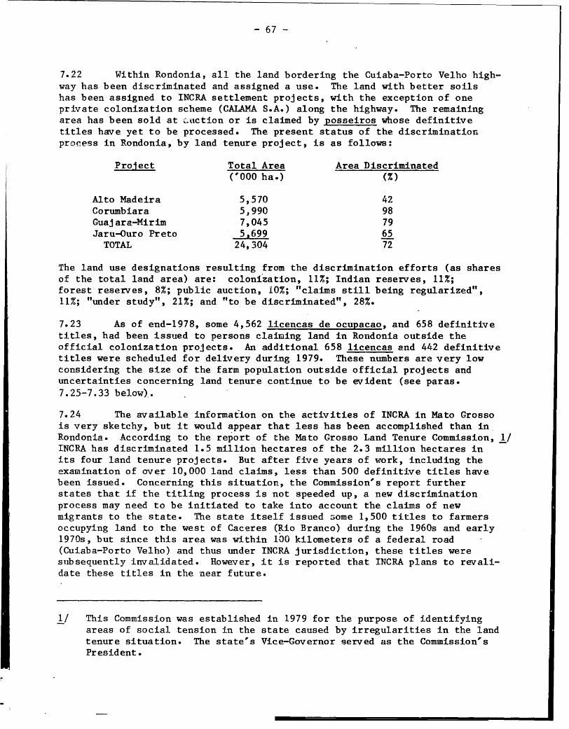
- 67 -
7.22 Within Rondonia, all the land bordering the Cuiaba-Porto Velho high-
way has been discriminated and assigned a use. The land with better soils
has been assigned to INCRA settlement projects, with the exception of one
private colonization scheme (CALAMA S.A.) along the highway. The remaining
area has been sold at Lauction or is claimed by posseiros whose definitive
titles have yet to be processed. The present status of the discriminatiorn
pro,ess in Rondonia, by land tenure project, is as follows:
Project Total Area Area Discriminated('000 ha.) (%)
Alto Madeira 5,570 42
Corumbiara 5,990 98
Guajara-Mirim 7,045 79
Jaru-Ouro Preto 5.699 65
TOTAL 24,304 72
The land use designations resulting from the discrimination efforts (as shares
of the total land area) are: colonization, 11%; Indian reserves, 11%;
forest reserves, 8%; public auction, 10%; "claims still being regularized",
11%; "under study", 21%; and "to be discriminated", 28%.
7.23 As of end-1978, some 4,562 licencas de ocupacao, and 658 definitive
titles, had been issued to persons claiming land in Rondonia outside the
official colonization projects. An additional 658 licencas and 442 definitive
titles were scheduled for delivery during 1979. These numbers are very low
considering the size of the farm population outside official projects and
uncertainties concerning land tenure continue to be evident (see paras.
7.25-7.33 below).
7.24 The available information on the activities of INCRA in Mato Grosso
is very sketchy, but it would appear that less has been accomplished than in
Rondonia. According to the report of the Mato Grosso Land Tenure Commission, 1/
INCRA has discriminated 1.5 million hectares of the 2.3 million hectares in
its four land tenure projects. But after five years of work, including the
examination of over 10,000 land claims, less than 500 definitive titles have
been issued. Concerning this situation, the Commission's report further
states that if the titling process is not speeded up, a new discrimination
process may need to be initiated to take into account the claims of new
migrants to the state. The state itself issued some 1,500 titles to farmers
occupying land to the west of Caceres (Rio Branco) during the 1960s and early
1970s, but since this area was within 100 kilometers of a federal road
(Cuiaba-Porto Velho) and thus under INCRA jurisdiction, these titles were
subsequently invalidated. However, it is reported that INCRA plans to revali-
date these titles in the near future.
1/ This Commission was established in 1979 for the purpose of identifying
areas of social tension in the state caused by irregularities in the land
tenure situation. The state's Vice-Governor served as the Commission's
President.

- 68 -
Types of Land Tenure
7.25 Owing to the confused land tenure situation prevailing in most ofthe Northwest, little is known about the distribution of land tenure arrange-ments by type. Data available from the 1975 Agricultural Census are sunmmarizedin Table 15. It appears that most farm units in the region are run by"owner-operators" and "squatters." These two groups account for about 85% ofthe establishments and almost all of the area under farms. Farms operatedunder tenancy and sharecropping arrangements accotnt for about 14% of theestablishments and have average sizes of 11 and 20 hectares, respectively.
7.26 The data suggest that the tenure situation of many producers isinsecure, and indeed it is probable that the number of non-owners was underes-timated by the census. First of all, the census coverage corresponds to only2% of the region's land area. Secondly, the census does not reflect theintense migration to the region which has taken place since 1975. Finally,the census does not provide information on the apparently frequent practiceaccording to the Ifato Grosso Land Tenure Commission, of issuing severaltitles to a given parcel of land.
7.27 Given the slow pace of titling observed over the past few years, itis reasonable to assume that the majority of the new settlers in the regionhave entered into tenancy or sharecropping arrangements with already estab-lished farmers, or have invaded public or private lands in newly opened areas.In Pondonia, for example, recently arrived families often take up residence onlots of others, usually relatives, and work for the owner until INCRA providesthem with their own lots. Arnother compmon practice is for the new settler tostake a squatters' claim on the fringe of an official colonization project,while at the same time working as a laborer on one of the farms within theproject.
7.28 The incidence of farmers without titles is also high in the MatoGrosso portion of the survey area. At present, there are estimated to be some30,000 posseiro families residing in the state, of which almost one-fourth(6,400) are in the municipios of Caceres, Barra do Bugres and Vila Bela.Though no information is available on the proportion of these families ille-gally occupying privately-owned land, the Mato Grosso Land Tenure Commissionhas I'.entified 34 areas in the zone of influence of the Cuiaba-Porto Velhoroad where conflicts over land tenure issues have arisen. The largestnumber (eight) of these areas are found in V7ila Bela, followed by Caceres(seven), Barra do Bugres (six), Tangara da Serra (six), Mirassol d'Oeste(three), Pocone (two) and Livramento and Varzea Grande (one each). For theseareas, the Commission has recommended that a special program be set up toaccelerate the regularization of land claims and to establish at least aminimuin level of infrastructure.

- 69 -
Table 15
NORTHWEST REGION: DISTRIBUTION OF FARMS BY MAJOR'TENURE GROUPS, 1975
Region Rondonia Mato-Grosso
Tenure Groups % farms % area % farms % area % farms % area
Owner-Operators 55.4 87.5 66.1 78.4 42.7 92.2
Tenants 10.4 0.6 1.7 0.2 20.6 0.9
Sharecroppers 3.5 0.4 3.4 0.8 3.6 0.2
Squatters 30.8 11.5 28.9 20.8 33.1 6.7
2- 2-
TOTAL 47,088 9,001 km2 25,483 3,082 kmn 21,605 5,918 km
Note: The total land areas (as opposed to farm areas) of the region, Rondonia, and
Mato Grosso are:. 410,158 kr.2, 243,044 km2, and 167,144 km2, respectively.
Source: FIBGE, Censo Agropecuario, 1975

- 70 -
Farm Size
7.29 Data on the size distribution of farms, drawn from the 1975 Agricul-tural Census (Table 16), indicate that a major proportion of the region's areaunder farms is in the hands of large landholders. More specifically, whilefarms of over 1,000 hectares comprised only 2.3% of the total establishments,they accounted for over two-thirds of the land area under farms. In contrast,smaller farms (up to 100 hectares) constituted about two-thirds of the estab-lishments, but only 7% of the land area.
7.30 The data summarized above, though clearly indicating a concentrationof farm ovnership in the region, do not adequately reflect the significantintraregional variations in the size distribution of farms. Such variationsare an important characteristic of the land tenure situation in the Northwestand are attributable to a number of factors incluc1 ing differences in land--use capability, the rate and extent of settlement, historical precedents,and government policy. Large differences in the size distribution of farmsare evident even at the state/territory level of disaggregation. From thisperspective, farm areas appear to be far more evenly distributed in Rondoniathan in Nato Grosso. Small (up to 100 hectares) and mledium (100-1,000 hec-tares) sized farms account for about two-thirds of the farm area in the fonnerbuit less than 15% of the area in the latter. The relatively more equaldistribution of farms in Rondonia is largely attributable to the implantationof the INCRA colonization projects which, as discussed earlier, are based on100-hectare lots. 1/ As yet, no INCRA colonization projects have been estab-lished in Mato Grosso, and settlement has generally proceeded on an ad hocbasis. Consequently, there is a wider array of farm sizes in the state,including a number of very large corporate cattle ranches.
7.31 Within Mato Crosso, the greatest concentrations of small and medium-sized establishments occur in the municipios of Varzea Grande, Caceres,Mirassol d'Oeste, Tangara da Serra, Barra do Bugres and, to a lesser extent,in Nossa Senhora do Livramento. In these areas, average farm sizes range from49 to 195 hectares, versus the 273 hectare average for the entire Mato Grossoportion of the survey area. By and large, these are areas of older settlementwhere agricultural development, based on annual and tree crops, is already ata fairly advanced stage, but where intense in-migration may still be observed.
7.32 The laLgest farms in Mato Grosso tend to be located in the nmunicipiosof Aripuana, Pocone and Vila Bela. In all three areas, establishments largerthan 1,O0 hectares account for well over 90% of the total area under farms.With regard to Aripuana, the highly skewed pattern of farm size distributionis largely due to the physical isolation of the area which, until recently,has impeded its occupation by migrants. In the two other municipios, the highincidence of large farms is associated with the predominance of extensivecattle raising. Particularly in Vila Bela, livestock development has beenencouraged by the federal government through the provision of generolus fiscaland credit incentives to corporations desiring to implant projects in the area.
1/ The impact of the INCRA projects on the distribution of farm sizes isreflected in the census data which show the average farm size in Rondoniafalling from 230 hectares in 1970 to 121 hectares

.- 71 -
Table 16
NORTHWEST REGION: SIZE DISTRIBUTION OF FARMS, 1975
Area Interval Region Rondonia Mato Grosso
(in hectares) % farms .% area % farms % area. % farms. % area
,410 35.0 0.8 19.1 0.5 53.8 0.9 .
10 - 100 30.2 6.1 28.0 10.0 32.8 4.0
100 - 1,000 32.4 25.8 51.8 56.3 9.7 10.7
1,000 - 10,000 2.0 28.8 1.0 16.8 3.2 35.0
, 10,000 0.3 38.6 0.0 16.4 0.5 50.2
TOTAL 47,149 9,001 km2 25,483 3,082 km2 21,666 5,919 km2
Note: The total land areas (as opposed to farm areas) of the region, Rondonia, and
Mato Grosso are: 410,158 km2, 243,044 km2, and 167,144 km2, respectively.
Source: FIBGE, Censo Agropecuario, 1975

- 72 -
7.33 Pegistered corporations may reduce their income tax liabilities byup to 50% if the resulting savings are invested in approved projects locatedwithin the legally defined Amazon region. Such funds may be used to financeup to 75% of the project. Land purchases are not financed through fiscalincentives, though the value of the land may be counted toward the minimum 25%share of "fresh money" to be contributed by the project owners. Between 1967and 1972, 16 such projects, ranging in size from 13,000 to 152,000 hectares,located in the municipio of Vila Bela and were approved for fiscal incentivesadministered by STJDAN+. hTowever, in recent years this form of development hasbeen discouraged by the government and proposals for livestock projects indensely forested areas of Amazonia are no longer approved by SUDALM.
F. Government Support Services
Agricultural Research
7.34 Agricultural research in Rondonia is mainly the responsibility ofthe Brazilian Agricultural Research Enterprise (EMIBRAPA), although specificstudies on cocoa are undertaken by the federal cocoa development agency(CFPLAC) in Ouro Preto, and simple fertilizer trials by the territorialextension agency (ASTEP-PO) under an agreement with the FA0_ An EMBRAPAresearch station is located just outside of Porto Velho and is staffed by 14agronomists. During 1979, investigations were programmed in the followingareas: rubber, cattle, coffee, corn, beans, rice, soils, and water buffalo.Research work is carried out at the Porto Velho station, in the Ouro Pretocolonization project, in Pimenta Bueno, and in six private holdings inVilhena, Cacoal, and Ji-Parana.
7.35 To date, the main priority of EMBFAPA has been pasture research, butthis is clhanging to give more emphasis to rubber and coffee cultivated withintercrops. In 1980, work was extended to soybeans and wheat, and to fruitcrops in general. In pastures, evaluation of new grass and legume species isunder way, and promising results are evident on the red-yellow latosolscharacteristic of the region.. A project to further investigate water buffaloproduction started in 1980; as yet no work is planned with pigs or other smallanimals. Work on subsistence crops is mainly directed at variety evaluationand fertilizer experiments.
7.36 Following the division of the original state, Mato Grosso is withoutany agricultural research facilities. The establishment of such facilities,to be partially financed by a World Bank loan (No. BR-1249) to EMBRAPA underthe first agricultural research project, is planned for 1981. In the meantime,a few variety tests and other simple agronomic trials are done by the stateextension service (EtfATER -M-T) in order to fill the gap.
Agricultural Extension
7.37 Institutions providing agricultural extension services in Rondoniaare specialized by crop: all annual crops, tree crops (except for cocoa andcoLfee), and livestock are under the responsibility of ASTER-PO; cocoa is the
I-

- 73 -
responsibility of CEPLAC; and coffen will be the responsibility of the BrazilianCoffee Institute (IBC), which has recently received authorization to startwork in the territory. ASTER-RO, established in 1971, is the principalinstitution providing technical assistance to low-income farmers; about 65% ofits budget is devoted to this end. Within this program, farmers are providedwith assistance in improving the production practices and marketing of rice,corn, beans, coffee, manioc and livestock. Instruction is also provided inthe areas of health, nutrition, and education. The central office of ASTER-ROis located in Porto Velho, and there are two regional offices, in Ji-Paranaand Pimenta Bueno, and nine local offices covering the various INCRA coloniza-tion projects. The number of local level extension agents was 46 in 1978 and45 in 1979.
7.38 During 1978, some 5,800 farmers were assisted by ASTER-RO, implyinga farmer-to-extension agent ratio of 125:1. However, the number of farmersassisted fell by more than half in 1979 as a result of insufficient funds forvehicle purchase, maintenance and operation, which seriously limited themobility of the extension agents. The shortfall in funds was primarily causedby INCRA's decision to revoke its financial support for ASTER-RO, supportwhich had previously accounted for between 35-40% of the latter's budget.Subsequently, the Rondonia agriculture secretariat has agreed to assumeresponsibility for INCRA's portion of the budget.
7.39 CEPLAC has an extension service to provide cocoa growers withassistance in technical matters and in obtaining credit from the PROCACAOline. 1/ The agency maintains a regional office, a -local office and a researchstation in Ouro Preto staffed by six agronomists, three tree crop specialists,and 11 middle-level technicians working as extension agents. CEPLAC is alsorepresented in Porto Velho (one upper-level professional), Cacoal (two agrono-mists and four extension agents),-Ariquemes (three agronomists and fourextension agents), and Jaru (two agronomists and seven extensioni agents).
7.40 The principal responsibility for extension work in Mato Grossorests with the state office of the federal Technical Assistance and RuralExtension Enterprise (EMATER-MT). This agency has 35 field extension staffbased in the area of influence of the Cuiaba-Porto Velho road. They aresupported by 21 headquarters staff in Cuiaba. Six of the Cuiaba staff operatethe state seed testing laboratory and seven are engaged full time in supportprograms for cooperatives. Thirty-five extension staff are graduates (20agronomists, 14 veterinarians and a forester), and they are supported by 15techn[cians (14 agricultural, onie zoological). The department has one vehiclefor every two field staff and adequate facilities for preparing written andaudio-visual extension material. Salaries are reasonably competitive withalternative private-sector employment. The service aims to work with groupsof 15 to 20 farmers, each field man supporting about five groups. This givesa theoretical coverage of about 3,000 farmers.
1/ The PROCACAO program, established in 1977, calls for an increase inBrazilian cocoa output to 700,000 tons by 1992, and includes the plantingof an additionral 100,000 hectares (out of a national total of 330,000)in Rondonia.

- 74 -
7.41 The effectiveness of EMATER-MT is hampered by the large distanceswhich have to be traveled, and no coverage is possible between Vila Bela andVilhena. Access is difficult except to farms located on main roads, and evenhere it is often restricted during the rainy season when advice is mostneeded. As a result, extension staff often have to wait for farmers to cometo them, rather than vice versa. Further limitations arise from the lack ofvalid extension messages due to the absence of supporting adaptive research,and to the other duties which extension staff also have to undertake which, inaddition to the gathering of crop. statistics, include'technical appraisals ofcredit applications on behalf of the Banco do Brasil, and family health programs.
Storage
7.42 In Rondonia, the Brazilian Storage Company (CIBRAZEM) operates 14warehouses - six equipped for grain drying and cleaning - with capacities from2,400 to 9,000 mt and a total capacity of 48,000 mt; 73 people are employedand the annual budget in 1979 was CR$31 million. A further small amount ofstorage is operated by cooperatives and the private sector. In Mato Grosso,storage is divided between CIBRAZEM (2,400 int), the state storage enterprise--CASEMAT (36,000 mt) and the private sector (72,000 mt). Rice is the mainproduct stored, although corn, beans, coffee, Brazil nuts and pasture seedsare also handled in smaller amounts. Both administrations have plans to buildmore warehouses which, in the case of Rondonia, would be sited off the mainroad and within colonization schemes.
7.43 Utilization of existing public sector storage is highly variablebetween seasons and usually well below theoretical capacity. The main reasonis the difficulty which the farmer experiences in transporting his rice,harvested during the rains, from his farm to the main centers in which mostexisting warehouses are located. Lack of marketing credit may also forcefarmers to sell immediately after harvest without storing, even though theywould get a better price by delaying. Thus, even though there may be a needfor increased storage and especially for greater drying capacity, it seemsunlikely that it will all be used effectively unless the constraints imposedby lack of access and credit can first be removed.
Credit
7.44 Credit is available to producers from a range of government programsincluding POLAMAZONIA, PROTERRA, PROPEC, PROCACAO and PROBOR. Funds areallocated for medium and long-term capital investment, seasonal or produc-tion credit, and marketing. Until December 1979, interest rates ranged from10 to 18% with no monetary correction. Presently, both principal and interestare adjusted by a factor equal to 40% or 70% (depending on the size of theloan) of the national monetary correction index (ORTN).
7.45 The principal credit channel is the Banco do Brasil (BB) which hasfive branches in Mato Grosso and five in Rondonia. In Rondonia in October1979, BB had a portfolio of Cr$900 million (US$36 million) covering about8,000 contracts. In Mato Grosso, 1977 BB disbursements were estimated tototal almost Cr$1.7 billion, of which 56% was for investment, 32% for pro-duction and 12% for marketing. The next most important official creditchannel is the Banco da Amazonia (BASA). Significant amounts of credit alsoreach agriculture from the private sector, mainly from the Brazilian DiscountBank (BRADESCO), with six branches in Rondonia. In total, there are 25 bankbranches in Rondonia and 12 in Mato Grosso.
- 75 -
7.46 Despite the apparent availability of adequate funds and the existence
of bank outlets in major population centers, the credit needs of many producers
are not satisfied.. I'ost farmers have no land title and are therefore at a
disadvantage when seeking rural credit. Those with title often have difficulty
in reaching the urban areas where applications must be made. Finally, the
bureaucratic procedures of the-banks, which often require loan decisions to be
referred from branches to central offices, can result in serious delays.
Cooperatives
7.47 The cooperative sector is poorly developed despite government
support programs through INCRA and the agricultural extension services.
There are only six operational cooperative societies in Mato Grosso and six
in Rondonia, four in each area being concerned with agricultural production.
Other cooperatives have failed from lack of management ability or enthusiasm
among members and several of the survivors have severe financial problems.
Total membership is less than 2,000 and even in Rondonia, with its prep-onder-
ance of small farmers, includes less than 5% of the farming population.
F. Constraints and Recommendations
7.48 Agricultural production is constrained by numerous factors, many of
which interact with each other. Among those discussed below, the limitations
imposed by poor physical access, lack of land title, and inadequate support
services are of the most immediate concern.
Physical Access
7.49 Main roads are often impassable in the rainy season and the n.etwork
of feeder and farm access roads is poorly developed. It is therefore diffi-
cult, and sometimes impossible, for the farmer to market his output when he
wishes. If he can do so, transport is costly. If he cannot move the crop
himself, he may sell to an intermediary at far below the urban market price.
Alternatively, the crop may spoil while held on the farm -- on-farm losses
have been estimated at up to 50%. In each. case farm gate returns are lowered,
leaving little incentive to produce. Poor roads, by restricting the inward
transport of bulky inputs, such as lime or fertilizers, and limitting the
farmer's access to government extension services and to neighbors, also
constrain intensive land-use and innovation. The farmer is instead pressed
tow>ard the exploitive use of land under extensive grazing; the cattle can at
least be walked. to market at the end of the rains. In order to rectify the
problems caused by poor access, the regional secondary and feeder roads
network must be upgraded and expanded in the areas of greatest agricultural
potential. (More detailed recommendations pertaining to regional roads are
presented in Chapter IX, paras. q.26-9.32).
Land Title
7.50 The fact that many farmers do not have title to their land is the
second major constraint to production. With no guarantee of occupancy, there
is little incentive to abandon the present low input/low output systems of

- 76 -
production or invest in long-term farm improvements. Furthermore, much labormay be wasted in excessive land clearance undertaken as a means of establish-ing occupancy for titling purposes. The land discrimination process should beconcluded as expeditiously as possible and titles issued with a minimum ofbureaucratic delay to qualified farmers occupying land in areas alreadydiscriminated.
Support Services
7.51 Agr4cultural research, which is at present confined to Rondonia,needs to be focused more directly on the production problems currentlyfaced by farmers. Research should therefore initially concentrate on topicssuch as: (i) selection and evaluation of crop varieties with better localclimatic adaptation and disease resistance; (ii) crop timing and productiontechniques aimed at intensifying production per hectare of land cleared,and increasing net financial returns per man day of available family labor;(iii) development of improved methods to reduce losses during crop growth andpost-harvest; and (iv) development of species mixtures and management systemsto increase the stability and carrying-capacity of seeded pastures. Thedelivery of research results to farmers, via demonstration plots and othertechniques formulated by a production-oriented extension service, alsoneeds to be Aiven more support. In addition, access to production and invest-ment cred_3t should be improved through the establishment of additional bankagencies (postos avancados) in the various settlement areas. This measurewould, in turn, need to be coupled with improvements in the efficiency of theextension serrices--the principal link between the farmer and the bank. To beeffective, the above measures would depend on prior improvement of farmaccess, so that there are adequate incentives for farmers to respond to advice,and adequate access to the inputs needed to do so.
Crop Drying and Storage
7.52 The use of existing crop drying and storage facilities is oftendenied to farmers because facilities are in main centers which they cannotreach. Improved access would have to be accompanied by expanded facilities tohandle present levels of production. Some post-harvest loss could also beavoided by the establishment of simple on-farm storage facilities, andby greater attention to preliminary sun-drying %Ahen weather permits.
Climate, Soils and Zonation
7.53 The high rainfall favors crop growth, but compounds the accessproblem because it accelerates the deterioration of roads. It thus acceler-ates post-harvest losses of crops which cannot be rapidly dried and stored.Combined with high humidity, rains also promote the development of weeds,pests and diseases (see para. 7.55 below). Partly due, aaain, to the accessproblem, farmers lack the technical skills and materials to make the bestreturns from the potentially usable soils, wlhile many, through lack of know-ledge, or a desire for short-term gain, have cleared and subsequently abandonedunsuitable soils, causing avoidable ecological damage.

- 77 -
7.54 In order to limit ecological damage in the future, land suitability
surveys should be made at a scale of 1:250,000 to cover all unoccupied
areas considered likely to contain soils which have potential for agriculture
and which are not already allocated to another purpose (forest and biological
reserves, ecological stations, national parks, etc.). Agricultural zones
should be delimited for those areas where potential is confirmed, and the
remaining land should be allocated to non-agricultural uses. Within the
agricultural zones, land suitability surveys should be done at scales ranging
from 1:25.000 to 1:100,000, depending on the potential intensity of land use,
to form a basis for infrastructure and settlement planning. The feeder road
network should then be concentrated within the identified agricultural zones.
Given the high rates of migration to the region, it is clear that current
settlement plans cannot be completely halted pending the outcome of the
land capability surveys and zoning exercise.recommended above. However,
such measures should be given high priority and completed as soon as possible.
Weeds, Pests and Diseases
7.55 Weeds are few in newly cleared forest land, but the humid climate
fosters rapid establishment if they are left uncontrolled. Forest regrowth
almost invariablyleads to the eventual abandonment of seeded pasture. Many
pests and diseases also develop rapidly. Rice blast and insect pests of maize
are particularly common, and diseases of beans are severe unless planting is so
late in the rains that there is an alternative risk of loss due to drought.
Witch's broom disease in cocoa, South American leaf blight on rubber, and coffee
leaf rust have already been mentioned. Although so far none of these constraints
are overwhelming, they may raise production costs and/or reduce yields, and im-
pose a need for resistant varieties which cannot always be met by the existing
sources.
Labor Availability
7.56 In the future, labor shortages are likely to continue (see para. 7.05).
Much of the area recently put under tree crops is in larger holdings than can
be managed by the labor of a single family. Most immigrants arriving in the
area wwith the aim of making a living in agriculture are seeking land, and will
develop a plot of their own, legally or illegally, rather than seek paid
employment. As plantings of coffee and cocoa mature, the availability of hired
labor for harvest is therefore likely to become an increasing constraint,
unless new arrivals are systematically given more opportunities to participate
in tree crop farming -- for instance as sharecroppers.
G. Production Forecasts
7.57 The agricultural production of the Northwest is expected to increase
rapidly over the next decades as immigration and the incorporation of new land
corm,,,es. In order to show the order of magnitude of this expected growth,
prw+LSb'ions of production were attempted for the years 1984, 1989, and 1994.
- 78 -
Thase projections were disaggregated spatially and were further broken downinto total, marketable, and exportable production. Moreover, recognizingthe paramount importance of public sector activity in the region, the projec-tions were made according to two separate scenarios. 1/ The basic assump-tions of these scenarios are as follows:
Scenario I
7.58 The first scenario envisages the future essentially as a continuationof past trends. That is, it is based on the assumptions that 'there will be nospecial investments to improve the Cuiaba-Porto Velho road or the feederroads network; no strengthening of institutions responsible for land-usezoning, Indian affairs, and environmental protection; and no improved landtitling or additional technical support for agriculture. Inappropriate landis developed by inappropriate means, leading to a continluation of the present,largely exploitative, methods of agriculture. Yields decline in tlle mediumand long terms. Market access becomes increasingly difficult as the agricul-tural perimeter expands, preventing access to inputs and leading to largeron-farm losses because farmers cannot evacuate their production.
Scenario II
7.59 The second scenario represents the future with a full range ofgovernment assistance along the lines proposed in the previous section anid inthe legislation establishing POLONOROFSTE. More specifically, the upgradingof the Cuiaba-Porto Velho road and improvement of the-feeder roads network islinked to a comprehensive program of agricultural development. The latterwould include measures to ensure that land is zoned according to agriculturalpotential and that feeder roads, physical and social infrastructure, andservices (including land titling) are implanted only in agricultural zones.Institutions responsible for non-agricultural reserves would be strengthenedto prevent, as much as possible, land clearing in these areas. Indiscriminateland clearing would be checked and, by good initial land selection, improvedland titling and technical support, there would be a move toward sustainedcropping, emphasizing tree crops, rather than the short-term exploitation ofland. Better land plus research and technical support would lead to an upwardtrend in yields in the medium to long terms, and the integration of feederroads with agricultural support would reduce on-farm losses.
Results
7.60 The results of the forecasting exercise described above are sum-marized in Tables 17 and 18. In the first of these tables, the expectedtotal production of various commodities are shown for the years 1984, 1989,and 1994. From this table it may be readily observed that the agricultural andtimber potential of the Northwest is considerable, especially if government
1/ More detailed information on the methodology and underlying assumptionsof these projections are presented in the Annex.

- 79 -
activity in the region expands along the lines and to the extent envisaged
under Scenario II. The average annual growth of agricultural production
between 1979 and 1994 could be in excess of 13%, as compared to the real
historical growth, rate for all Brazilian agriculture of about 5% per annum.
Potential rates of growth are particularly high for tree crops and, under the
conditions of Scenario II, the regional production of cocoa in 1994 would be
close to the national total reached in th2 late 1970s.
7.61 Fven if government activity remains at current levels, the growth
in agriculture over the next 15 years could be on the order of 8% annually.
However, this finding does not imply that the proposed improvements in the
region's physical and social infrastructure and services should not be carried
out. On the contrary, by not making such improvements the region would be
foregoing almost 2.9 million tons of agricultural production per year by i994.
In addition, failure to institute measures dealing with the regularization of
land ownership, environmental protection, Indian rights, and land-use planning
could very well jeopardize the future development of the region in ways (e.g.,
through an, aggravation of social tensions and needless environmental degrada-
tion) not fully reflected in the production figures.
7.62 Future market conditions for the major traded agricultural commo-
dities of the Northwest are mixed. For coffee, real prices are expected
to decline gradually until the mid-1980s and then rise moderately for the
rest of the decade. The real unit price in 1989 (US$3,024 per mt at 1980
constant prices), however, is expected to be only 80% of that reached in 1979
(IJS$3,789 per mt). TTnder the assumptions of Scenario II, the annual coffee
production of the Northwest could, by 1989, be accounting for about 15% of the
national total, equivalent to approximately 5% of world imports. The market
for cocoa is expected to weaken considerably over the present decade, owing
primarily to high levels of world production assumed for the late 1980s, and
the increasing success in the use of cocoa substitutes in chocolate and
confectionery. As a consequence of these factors, the unit price of cocoa at
1980 constant prices is expected to decline by about 40% over the decade, from
TJS$3,489 per metric ton in 1979 to TJS$2,073 in 1989. ITnder Scenario II, the
Northwest's output of cocoa could account for 20% of Brazil's total, and equal
7% of world imports by 1989. In contrast to coffee and cocoa, the market
prospects for rubber, rice and timber are good and their real unit prices are
projected to increase at annual rates averaging 0.6%, 0.4%, and 4.0%, respec-
tively, over the 1979-89 period.
7.63 Despite the fact that prices for coffee and cocoa in both 1984
and 1989 are expected to be lower than those prevailing in 1979, the real
value (at border prices) of the combined production of coffee, cocoa, rubber,
rice and timber should increase substantially. ITnder the assumptions of
Scenario II, coffee becomes the region's most important cash comnmodity by the
mid-1980s, followed by rice, timber, cocoa and rubber (see Table 18). The
total value (in constant 1980 IJS dollars) of the five commodities in question
is expected to reach around TJS$772 million by 1984 and IJS$1.6 billion by 1989,
the latter figure being over six times the 1979 baseline. The large differences
between these totals and, those attained under Scenario I are particularly

TABLE 17
NORTH-EST REGION: FORECAST OF TOTAL AGRICULTURAL AND TIMBER OUTPUT, 1984, 1989 AND 1994
('000 metric tons)
BASE SCENARIO I SCENARIO II1979 1984 1989 1994 1984 1989 1994
Tree Crops
Coffee (processed) 28 52 68 80 98 224 272Cocoa 5 8 53 100 34 129 191Rubber - - 4 26 1 17 120
Annual Crops
Rice (milled) 128 293 428 532 429 697 861 1Corn 114 203 305 392 355 586 694 coBeans ** 14 38 57 68 57 98 115 0Other 244 400 600 640 1,080 1,845 2,232
M e a t 43 51 65 83 74 139 216
Sub-Total 577 1,045 1,580 1,921 2,128 3,735 4,701
Timber 221 375 550 628 513 650 734
TOTAL 798 12420 2,130 2,549 2,641 4,385 5,435
* Less on-farm losses, use as seed, etc.** Manioc taken as proxy to represent all other crops (peanuts, cotton, vegetables, tc.)
Source: IBRD, Northwest Economic Survey mission. Subsequently revised.

- 81 -
striking (US$319 million in 1984 and US$827 million in 1989) and suggest that
the POLONOROESTE program aimed at upgrading the regional road network, coupled
with measures to improve land use planning and agricultural practices, could
have a very rapid and high return.

TABLE 18
NORTHWEST REGION: ESTIMATED VALUE OF KEY TRADED COMMODITIES, 1984 AND 1989 *(millions of constant 1980 US$)
BASE SCENARIO I SCENARIO II
1979 1984 1989 1984 1989
Coffee 106.1 140.4 205.6 264.6 677.4
Cocoa 17.4 22.7 109.9 96.5 267.4
Rubber - - 6.5 1.5 27.5
Rice 62.0 141.8 216.6 207.2 352.7
Timber 61.0 148.1 224.4 202.6 265.2
TOTAL 246.5 453.1 763.0 772.4 1,590.2 X
* Based on forecasts of tota'l output as shown in Table 17.
Source: IBRD, Northwest Economic Survey mission. Subsequently re-4ised.

- 83 -
VIII. INDUSTRY
8.01 Industrial activity is still of relatively little significance in
the Northwest. The industrial sector of Mato Grosso accounted for only 9% of
the state's product in 1970 and, as late as 1978, was the source of just 5%
of its value-added tax (ICM) revenues. Industry is of far greater relative
importance to the economy of Rondonia, accounting for about 20% of the terri-
tory's product in 1975, but almost all industrial production is attributable
to a few large-scale cassiterite mining operations. 1/
8.02 At the time of the 1970 Industrial Census, the Northwest contained
a total of 584 industrial establishments, employing about 3,500 persons. In
Mato Grosso, industry was (and still is) concentrated in the Cuiaba-Varzea
Grande urban agglomeration (accounting for 73% of the firms, 84% of the employ-
ment, and 65% of the value-added), although Caceres is emerging as an important
second-level center. In 1970, about three-fourths or Rondonia's industrial
establishments were located in Porto Velho, with most of the balance being
accounted for by firms in Ji-Parana and Guajara-Mirim.
A. Industrial Struccure
8.03 As is typical of natural resource and agricultural frontier areas in
rapid expansion, industrial activities in the Northwest are of two basic types:
extractive or primary product/raw material processing activities or local
service industries, especially those involving food processing, furniture
making, and construction. Firms are generally small and characterized by re-
latively primitive technologies and low levels of fixed capital investment,
the large mining companies being the major exception. This industrial
structure is typical of both Mato Grosso and Rondonia. In the former,
for example, among the 652 industries registered by the state Secretariat
of Finance in April 1977, 22% were food processing establishments (primarily
grain drying and cleaning operations, and small bakeries), 18% were
construction firms, 12% were sawmills, and 11% were vehicle repair shops.
In Rondonia, 36% of all industrial establishments registered by the
territorial Secretariat of Planning in 1978 were sawmills, 29% were food
processing activities, 11% were furniture making operations, and 9% were
brick and tile making enterprises.
8.04 Thie available data permit us a more accurate view of industrial
structure and growth in Rondonia than in Mato Grosso. Since 1970, the
number of establishments in Rondonia has doubled, and industrial employment
has grown at about the same rate. Lumber, food processing, and non-metallic
mineral establishments predominate. The recent growth of lumbering concerns
is a consequence of the process of land clearance and settlement in the
territory. From the standpoint of employment, mining, lumber, food products,
and non-metallic minerals (brick and tile making), are the most important
1/ Rondonia, northwest Mato Grosso, and southern Amazonas are estimated
to contain 82,000 metric tons of cassiterite, or 95% of Brazil's
provbn reserves of this mineral.

- 84 -
industrial subsectors. In terms of the total value of industrial production,1975 data reveal that cassiterite mining activities accounted for 53%; sawmills,15%; rubber processing plants 11%; rice processing firms, 5%; and furnituremakers, bakeries, frozen fish plants, and brick and tile makers, 2% each.Three subsectors were thus responsible for more than three-fourths of thetotal value of industrial production in the territory.
8.05 Most industrial establishments in,Rondonia are relatively small,the major exception being the cassiterite operations which average more than400 employees per firm. All other activities, except rubber processing (with35 employees per firm) had an average of ten employees. In nearly all cases,part of the output of these firms is exported either to the south (Sao Paulo,Rio de Janeiro, Minas Gerais, and Rio Grande do Sul), or to the north (Acreand Manaus). However, processed Brazil nuts and some of the lumber produc-tion are also sold on international markets.
8.06 Small firms are also the rule in Mato Grosso. According to 1977data, there were only 31 firms having more than 50 employees in this part ofthe Northwest. Two firms having more than 1,000 employees were both locatedin Cuiaba, one being a large construction company (with a total of 2,149workers), and the other the state electrical energy company (with a total of1,588 employees). Outside the Cuiaba-Varzea Grande area, and with the except-ion of a single wood-processing operation and two medium-sized food process-ing and non-metallic minerals firms in Caceres, industrial establishmentswere all relatively small. The largest employers in Barra do Bugres, Mirassold'Oeste, Pocone, Tangara da Serra, and Vila Bela, for example, are sawmillswhich employ up to 20 workers each. In 1977, the total industrial employmentin these municipios amounted to only 58 jobs, as compared with 292 positionsin Caceres, 1,416 in Varzea Grande, and 7,952 in Cuiaba (of which 6,606 were inconstruction and electrical energy production).
B. Constraints and Prospects
8.07 The relative insignificance of industrial activity in the Northwestis primarily the result of serious deficiencies in physical infrastructureand a reduced, albeit rapidly growing, regional market. The principal obs-tacles to regional industrial development as seen by local government officialsand entrepreneurs alike, are an inadequate supply of electrical energy and poorroads. The former represents an obvious constraint on industrial activitieswhich demand large quantities of electrical energy, while the latter resultsin high freight costs sharply reducing the competitiveness of local manufac-tured products in extra-regional markets and increasing the cost of necessaryinputs and raw materials originating both within and outside the region.
8.08 Both Mato Grosso and Rondonia are currently attempting to increasetheir electrical energy generating capacity and to improve their primary andfeeder road systems. Construction of the 217 MW Samuel hydroelectric facil-ityand associated transmission lines would significantly increase the supply ofenergy in the northern part of Rondonia, between Porto Velho and Ji-Parana.Plans in Mato Grosso to increase hydroelectricity capacity are concentrated inthe area near the capital, extending as far east as Rondonopolis and as far

- 85 -
west as Caceres. The paving of the Cuiaba-Porto Velho road will have a sig-nificant effect in reducing freight costs, especially in Rondonia, both ofimported and local inputs and final products, thereby directly stimulatingindustrial production in the territory.
8.09 The current rates of migration and population growth in the region,moreover, guarantee wile growth of localrmarkets for a broad range of finalconsumption and intermedi.ate commodities, many of which are now importedfrom the South. Prospects over the medium run also continue to be very goodfor the major extractive industries in the region, especially those based oncassiterite, lumber and extractive agricultural products. Agroindustrialproduction, in turn, should expand significantly, especially as the productionof coffee and cocoa in colonization areas in Rondonia increases, as well asthe continued production of cattle in Mato Grosso and rice and other foodproducts in both Mato Grosso and Rondonia.
C. Industrial Policy
8.10 The principal instrument of local industrial policy in the Northwestis the creation of industrial districts, consisting of lots for the installa-tion of manufacturing activities sold to private entrepreneurs at nominalprices and with physical infrastructure provided by the state government. Anindustrial district has begun in Cuiaba, and three firms, employing 180 people,have already located there. Five additional firms are scheduled to initiateoperations in the near future. Nearly 300 firms have expressed interest inthe industrial district of Cuiaba, most of which are in the lumber, food pro-cessing, or construction materials industries. The government of Mato Grossoalso intends to install a smaller industrial district in Caceres. The govern-ment of Rondonia plans to establish industrial districts in Porto Velho,Ji-Parana and Vilhena.
8.11 In addition to the installation of industrial districts and theimprovement of energy and transport infrastructure, both the state of MatoGrosso, through its Secretariat of Industry and Commerce, and the territoryof Rondonia, throurh the Secretariat of Planning, are studying industrialdevelopment opportunities to stimulate the private sector (both local andnon-local capital) to initiate activities in sub-sectors where there is alocal comparative advantage. More specifically, Mato Grosso is prepar-ing industrial profiles for the following products: lumber, grains, vegeta-ble oils, rubber and rubber products, babacu, vegetable charcoal, meat pro-cessing, leather and leather goods, dairy products, sugar refining, alcohol,and cement products. Rondonia is analysing investment opportunities in:fruit processing, tile and brick making, soaps, wooden furniture, and animalfeeds. Both Mato Grosso and Rondonia also plan to provide technical assistanceto small and medium industries. In Rondonia, finally, plans also exist to usePOLAMAZONIA funds to implant meat processing and dairy operations in Porto Velho,as well as a cocoa processing establishment in Ouro Preto. A second dairy pro-ducts operation is scheduled for implementation in Ji-Parana in 1981.

- 86 -
8.12 In Mato Grosso, a state Secretariat of Industry, Commerce, andTourism and an Industrial and Commercial Development Council have recentlybeen installed, and the government also plans to create a general deve-lopment credit program (carteira) in the state commercial bank destined, inpart, to promote industrial investments. The use of ICM reductions as afiscal incentive to industrial activities on the local level is also beingconsidered in both Mato Grosso and Rondonia, although no specific measureshave yet been taken. While Mato Grosso and Rondonia are both in LegalAmazonia, to date neither has been a significant recipient of SUDAM fiscalincentives ior industrial projects. But both the state and territorialgovernments wish to increase local participation in this program. Rondonia,moreover, is currently seeking to have the full benefits of the Manaus FreeTrade Zone extended to Porto Velho in order to stimulate industrial devel-opment. 1/
1/ At present, only imports of "first necessity" items are permitted toenter Rondonia duty free. For more details on the Manaus Free TradeZone, see D.J. Mahar, "Fiscal Incentives and the Economic Developmentof Western Amazonia", Brazilian Economic Studies, 2(1976), pp. 147-74.

- 87 -
IX. TRAMNSPORTATION
A. Overview
9.01 The construction of the Cuiaba-Porto Velho road has had, and con-
tinues to have, a profound effect on the rate and pattern of the Northwest's
occupation anld development. In fact, before the 1960s much of the region was
inaccessible (except with great difficulty) by overland means and both popula-
tion and economic activity were largely confined to riverine areas. Today,
rapidly growing towns and cities exist at numerous points along the road
and a significant increase of agricultural production may be observed in the
hinterlands. However, the ,resent condition of the main road is now a major
constraint on the future development of the Northwest. So too is the region's
inadequate system of secondary and feeder roads, which hampers farm-to-market
access, as well as the population's use of social infrastructure and services.
In light of the government's intention to improve the transport system as part
of its overall development program for the Northwest, it is useful to describe
the present situation in more detail, calling special attention to some of,the
more important problems and issues.
B. The Present System
9.02 The Northwest is served by air, river and road transport. Of the
three, overland transport is the most important in terms of moving goods and
people within 'he region, and between it and the rest of Brazil. In 1978,
the region was estimated to have produced about 1.1 million tons of goods,
mostly agricultural products (about 900,000 tons), wood either in logs
or semi-processed (about 130,000 tons), cattle (about 30,000 tons), and
minerals (mainly cassiterite in Rondonia). About 513,000 tons are estimated
to have been exported from the area; 98% by truck and the rest by air and
river transport. An estimated 840,000 tons of goods were brought into the
region, consisting mainly of manufactured products and construction materials
originating in the Sao Paulo area, fuel and oil mostly barged in from Manaus,
and household goods accompanying the strong migratory flows.
Airports and Landing Strips
9.03 There are 28 airports in the Northwest. Two of them (Cuiaba and
Porto Velho) are main line, trunk airports capable of handling jet aircraft,
and three are secondary paved airports (Ji-Parana, Guajara-Mirim and Viihena).
The 23 remaining facilities, with gravel and earth runways, are scattered
throughout the area. In addition to these airports, there are countless
landing strips at smaller localities and farms. Air navigation facilities in
the region are reported to be poor and widely scattered, making flying in the
area hazardous, particularly during the rainy season when demand for this mode
of transportation is high.

- 88 -
9.04 In Rondonia, and to a certain extent in Mato Grosso, it has beenmainly the federal government that has taken the initiative of providingpublic airports and landing strips. Local authorities in the region arestill financially and structurally too weak to undertake these activitiesalone. However, the government of Rondonia and INCRA have set up a jointprogram to build landing strips at remote localities and this effort ishaving a favorable impact on the economies of some of the official coloniza-tion projects.
Navigable Rivers and Ports
9.05 Some of the rivers of the Northwest flow north toward the Amazon(practically all rivers in Rondonia) and some flow south toward the Parana andthe Plate (practically all rivers in the Mato Grosso part of the region).There are two important navigable river systems in Rondonia -- the Madeiraand the Mamore-Guapore. The latter is an affluent of the first, but notconnected to it by navigation owing to a series of rapids located betweenPorto VeTho and Guajara-Mirim. The Madeira is formed by the Beni and theMamore rivers, both of which mark the .border between Brazil and Bolivia.It runs for 3,240 kilometers before joining the Amazon only a short distancefrom Manaus. Like most amazonic rivers, it is wide (over 800 meters atplaces) and deep (about ten meters on average). However, its curves are oftennarrow, and the navigable channel is constantly shifting. Moreover, the manyfloating logs in the river (giving the river its name) are hazardous tonavigation. Nonetheless, the Madeira is navigable year-round for ships andbarges of up to 600 ton capacity, from its mouth to Porto Velho.
9.06 Porto Velho is the region's only port on the Madeira. However,it is a precarious facility built on a river bank in one of the few areasclose to Porto Velho without a silting problem. The port's limited infra-structure consists of two small cranes (1.5 tons at 30 meters and 4.5 tonsat 20 meters), a paved yard, and a storage shed. As such, it is inadequatefor handling large volumes of freight. The port of Porto Velho is administeredby the federal port authority (PORTOBRAS). In addition to the PORTOBRASfacility, there are a number of private wharfs and landings used by small,local shipping enterprises which operate mostly mixed passenger and freightservices to riverine communities to the north.
9.07 The Mamore-Guapore system borders Rondonia on the south where itdelimits the Brazil-Bolivia border. It is navigable, with restrictionsin the summer, from Guajara-Mirim in Rondonia to Vila Bela in Mato Grosso --a distance of about 1,100 kilometers. There are no port facilities along thebanks. In general, the area through which this system flows is swampy andperiodically inundated. Hence, most economic activities, except for theexploitation of rubber, tend to be seasonal.
9.08 Both the Madeira and the Mamore-Guapore river systems were themajor avenues of access to Rondonia in the past, when the regional economywas mostly based on the extraction of natural rubber. Since the Mamoreand Madeira could not be joined by navigation, a railway was built betweenPorto Velho and Guajara-Mirim to move the rubber produced in the area.However, with the decline in the demand for rubber, the railway lost mostof its traffic and has since been abandoned and replaced by a road.

- 89 -
9.09 There are two important navigable rivers in the Mato Grosso part
of the survey area: the Paraguay, which eventually runs into the Parana and,
in turn, into the Plate; and the Cuiaba, one of the Paraguay's affluents.
The Paraguay river rises north of Caceres at the foot of the Parecis plateau
and runs south through Caceres where it becomes navigable for its next
1,300 kilometers. It is joined by the Cuiaba about 950 kilometers south of
Caceres, continues parallel to the Brazil-Bolivia border and at Coimbra,
becomes the Brazil-Paraguay border. Of relevance to the survey area is the
720 kilometer section from Caceres to Corumba in Mato Grosso do Sul, where
the river is navigable for ships and barges of up to 500 tons. At Caceres
there are limited port facilities which include a transit shed and a conveyor
loading belt. The situation is similar at Ladario (located next to Corumba)
where a rail terminal of the Estrada de Ferro Noroeste do Brasil exists.
Despite its limited facilities, the waterway is reported to have been used
successfully in recent years by grain shippers from the Caceres-Mirassol
d'Oeste area.
9.10 The Cuiaba river is an important affluent of the Paraguay. It
runs 625 kilometers before joining the latter (of which 367 kilometers are
navigable) between Porto Cercado and the junction. Porto Cercado is 145
kilometers by road from Cuiaba and has had a growing cement traffic in
the last few years. At present, the only port facility available at Porto
Cercado is owned by the Itau Cement Company, but the Mato Grosso state
government has plans to build a wharf there. This wharf would facilitate
navigation destined for riverine communities in the state and for those
located in Mato Grosso do Sul (including the rail terminal at Corumba).
Roads
9.11 Roads are the core of the Northwest's transport system. In Mato
Grosso part, there are two overland axes which concentrate all area flows:
BR-163/364, the northern route from Cuiaba to the Rondonia border; and BR-070/
174/364, the southern route, which passes through the cities of Caceres, Porto
Espiridiao, and Pontes e Lacerda before joining the northern route close to
the Rondonia border. 1/ There is just one spinal axis in Rondonia, that is,
BR-364. These routes are all federal roads and represent the heart of the
regional network. In total, there are 1,303 kilometers of federal roads in
the Mato Grosso part of the region, and 1,450 kilometers in Rondonia. Except
for 45 kilometers in Mato Grosso and 75 kilometers in Rondonia, all roads are
unpaved. About half are gravelled and the rest are earth and natural terrain
roads. Quite a few of them, particularly in Rondonia, are essentially tracks
opened for seasonal use.
9.12 The federal road network is generally in fair condition. However,
some sections, particularly the more travelled ones of the primary axis, have
deteriorated to a very bad conditions In fact, during the rainy season, these
poor sections may be cut off altogether, isolating much of the Northwest from
the rest of Brazil for weeks at a time. During the last few rainy seasons,
for example, BR-364 has been closed to all vehicles with more than two axles.
1/ The southern route in Mato Grosso, plus BR-364 in Rondonia, is commonly
referred to as the Cuiaba-Porto Velho road.

- 90 -
9.13 Responsibility for the federal network rests with the NationalHighways Department (DNER). While DNER maintains a well staffed regionaloffice in Mato Grosso, it has no representation in Rondonia. Federalresponsibilities are shared between DNER's regional offices in Cuiaba andin Manaus. Owing to the remoteness of the region and its border-area status,DNER, in turn, has delegated its responsibility for maintaining the mostimportant sections of the federal network to the Army. However, maintenancehas been difficult, and parts of the Cuiaba-Porto Velho road have deterioratedto a point where normal maintenance is no longer feasible and where only areconstruction of the road would ensure year-round traffic.
9.14 In addition to the federal network, there are 1,828 kilometersof state roads -- 1,082 kilometers in Mato Grosso and 746 kilometers inRondonia. Except for 76 kilometers which are double surface treated, andsome 650 kilometers which are gravelled, all state roads in the survey areaare earth roads. Their condition is generally poor, and many are only seasonalroads. In Mato Grosso, responsibility for state roads rests with the HighwayDepartment (DERMAT). In Rondonia, this function is exercised by the Secretariatof Works. This latter agency is, however, understaffed. BERMAT, in contrast,is well-staffed and reasonably well-equipped. Moreover, recent investments inequipment by the state government have significantly improved its maintenancecapability.
9.15 Finally, the Northwest has about 6,500 kilometers of municipalroads, distributed about equally between Mato Grosso and Rondonia. Theseare local roads generally of a very low standard. A few are collectorroads built in accordance with some engineering criteria, but most areaccess roads built without engineering designs on the basis of self-helparrangements (mutirao). Responsibility for these local roads would normallyrest with the municipal government of the area in which they were located.However, few municipalities are capable of carrying out this function. As aconsequence, the state and territorial governments have been assisting somemunicipalities with equipment and engineering know-how. Because the construc-tion standards of state and municipal roads are similarly low, it is difficultto identify clearly (particularly in Rondonia) the scope and area of action ofthe different levels of government in road building and maintenance.
9.16 In addition to the overall lack of local rrads in the Northwest(there is 1 kilometer of local Eoads for every 50 km of area in Mato Grossoand 1 kilometer for every 75 km in Rondonia), there is a serious problemwith the maintenance of the few roads that do exist. Since local roads aregenerally those which provide direct access to the farming areas where mosteconomic activities are presently taking place they should be able to sup-port year-round traffic. Yet these roads were built, for the most part, tostandards that do not allow them to stay open year-round.

- 91 -
9.17 In sum, the Northwest's road system is weak. The federal spinal
network requires reconstruction and, as will be suggested below, paving as
well. The state network is of an extremely low standard and hardly ever
maintained. Thus, to ensure year-round access, it would need both upgrading
and systematic maintenance. Finally, the local network is limited and in poor
condition and also needs to be upgraded and maintained adequately. While
these numerous tasks might be carried out efficiently by the federal, state
and municipal agencies presently operating in Mato Grosso, the organization
in Rondonia is, at present, less capable of doing so.
C. Current Traffic Flows
Air Transport
9.18 Two main trunk carriers serve the Northwest--VASP (Viacao Aerea
de Sao Paulo) and Cruzeiro, a Varig subsidiary. Both airlines provide
regular daily service to Cuiaba and Porto Velho from other parts of Brazil
with modern jet aircraft. One regional carrier, TABA (Transportes Aereos da
Bacia Amazonica), operates in the region with smaller aircraft and regularly
serves towns like Guajara-Mirim, Ji-Parana, and Vilhena. There are also anumber of air taxi services operating mostly out of the capital cities.Considering only the main trunk carriers, the airports of Cuiaba and Porto
Velho had a combined through-put of 155,000 passengers in 1977, the most
recent year for which such data are available. In the same year, these two
airports handled a rather insignificant 2,000 tons of air freight. However,
despite this low level of activity, air transport is, when road conditions are
poor, about the only means of connecting the region with the south.
Inland Navigation
9.19 Porto Velho is the most important inland port of the region. It
is served by a number of small shipping companies and occassionally by ships
of the government-owned Amazon Shipping Company (ENASA). There are, howev"er,
no regular services. Traffic is quite imbalanced at Porto Velho and inbound
flows are over four times greater than outbound flows at the PORTOBRAS-operated
facility (34,000 and 8,000 tons, respectively, in 1978). Although overall
traffic is reported to be higher on the private wharves and landings near
Porto Velho (about 160,000 tons in 1978), the imbalance of inbound to outbound
traffic is estimated to be on tne order of eight to one.
9.20 A number of small companies provide intraregional transport services
on the Mamore-Guapore river system. It is estimated that the largest of these
companies, the Guapore Navigation Service, carries only about 2,700 passengers,
and 1,500 tons of freight, per year. The Paraguay system in Mato Grosso is
also serviced by comparatively small shippers, the largest being the government-
supported Plate Basin Navigation Service (SNBP). Unfortunately, no official
data are available on the overall traffic on this river system or on thefreight handled by the two major ports in the survey area, Caceres and PortoCercado. According to one unofficial report, about three million sacks(roughly 150,000 t6ns) of r'ice were shipped from Caceres to the rail terminal

- 92 -
in Corumba (Ladario) in 1978. Though this report probably exaggerates thetonnage actually hauled, it does point out the possibility of further utilizingriver-road or river-rail connections. This, and the more intensive use ofthe M4adeira river, would appear to be the only reasonable inland navigationprospects for the future.
Road Transport
9.21 Road transport accounts for the vast majority of regional trafficflows. In 1978, an estimated 1.3 million tons of freight, and well overfive million passengers, were carried by this means. Though complete infor-mation on the composition of freight carried overland is not available, itwould appear that the major items are those typical of a frontier area at anearly stage of development. Regional exports consist mainly of primarygoods such as minerals, lumber, and agricultural products; and impor.tsare mainly manufactnred goods such as machinery, parts, chemicals, andpharmaceuticals.
Q.22 Although the flow of vehicles along the main trunk highway (Cuiaba-Porto Velho) varies seasonally, the average daily flow may be inferred fromscattered traffic counts. Traffic for each of seven sections was estimatedon the basis of counts carried out in Rondonia (June, July, August and October1980) by the Brazilian Transport Planning Enterprise (GFIPOT) and in MatoGrosso (1979 and first, second and third quarters of 1980) by DERMAT. Theresults of these counts are summarized below:
Section Average Daily Traffic(No. of vehicles)
Porto Velho to Ariquemes 407Ariquemes to Ji-Parana 506Ji-Parana to Rio Rondon 603Rio Rondon to Barracao Queimado 365Barracao Oueimado to Porto Espiridiao 230Porto Espiridiao to Caceres 684Caceres to Cuiaba 486
9.23 Virtually no information is available on traffic flows on stateand local roads. Yet, a sizeable proportion of the passengers and freightmoved on the main trunk roads originated in areas removed from these roadsand, therefore, must have initially used the secondary and local network.However, only case-by-case reviews of activities in relevant sub-areas wouldprovide the necessary information.

- 93 -
D. Estimated Future Traffic Flows
9.24 Because road transport accounts for such a large proportion of
regional traffic flows, it is important to estimate the future development
of such traffic to assess its implications for future project design. Based
on the agricultural, forestry and livestock production estimates, presented in
Chapter VII, estimates were made of likely traffic on BR-364 for 1984, 1989
and 1994. In order to arrive at the traffic estimates of future traffic
columes, two categories of traffic were distinguished and handled separately,
viz., agricultural export traffic and other traffic. For the agricultural
export traffic the forecasts of exportable agricultural surpluses (Annex Table
3) were allocated to specific geographically defined administrative units and,
thence to road construction lots, thus establishing a direct link between
agricultural export production and traffic. *Next, these relationships were
translated into the number of originating trucks. It was assumed that exports
originating in 1lato Grosso would all go towards the Southeast whereas exports
from Rondonia would be evenly split between the Southeast and Manaus.
9.25 The balance of the traffic, i.e., non-agricultural export traffic,
has been assumed to develop at the same rate as the agricultural production
which is taken as a proxy for general economic development. The results of
the traffic forecasting exercise are summarized below:
Section Average Daily Traffic (no. of vehicles)1984 1989 1994
Port Velho to Ariquemes 1,116 2,104 2,691
Ariquemes to Ji-Parana 1,007 2,062 2,112
Ji-Parana to Rio Rondon 1,289 2,245 2,785
Rio Rondon to Barracao Queimado 874 1,594 2,265
Barracao Queimado to P. Espiridiao 676 1,139 1,446
Porto Espiridiao to Caceres 1,896 2,924 3,324
Caceres to Cuiaba 704 946 1,076
E. Issues and Recommendations
neneral
9.26 Based on the review of the existing transport system, current
traffic flows, and anticipated future flows, the future development of the
sector should center around improving the safety of air transport, increasing
the efficiency of river transport, and expanding and upgrading the road
network. Major new investments in infrastructure, however, are indicated only
for the latter. There seems to be some capacity available in river and air
transport, and the nature of the Nqorthwlest's development, with its emphasis on
expanding the agricultural frontier and consolidating existing agricultural
undertakings, would indicate that providing access to farms should receive
precedence.

- 94 -
9.27 Though the future demand for, and supply of, transportation serviceswill most likely be concentrated on the main road network and year-roundstate and local roads, the reported lack of adequate air navigation facilitiesis a matter of serious concern, particularly because passengers, rather thanfreight, are primarily involved. A thorough study of this problem thereforeseems warranted. With regard to inland navigation, a more efficient interfacebetween trucks and ships needs to be achieved on both the Madeira and Paraguayrivers. Wlhile this would generally entail improvements in administration,labor productivity, and equipment on the land and river sides of the interface,a detailed study is needed.
9.28 Roads will require the largest infrastructure investments. First ofall, given the level of traffic flows and the generally poor condition of theCuiaba-Porto Velho road, it will need to be reconstructed and paved. Secondly,the region's inadequate state and local roads network will require expansionand upgrading in close coordination with existing and proposed agriculturaldevelopment and settlement programs. Federal and state agencies operating inthe region have already proposed, and are currently preparing the necessarystudies to implement, both undertakings (see paras. 9.30-9.32 below). However,it will be necessary to strengthen the agencies directly involved, especiallyin Rondonia. Furthermore, provision would have to be made for the futuremaintenance and continued construction, as needed, of additional highways androads.
9.29 Before undertaking the ambitious program described above, inter-governmental responsibilities and financial obligations need to be clearlydefined. Given the embryonic stage of municipal government in much of theregion (particularly in Rondonia), the responsibility for part of the localroads may need to be assumed by the state and territorial governments, Acoordinated program and budgeting system also needs to be established. Underthis system, programs would be carried out by the responsible administrativeentity according to an overall action plan tailored to take into account eachentity's financial capacity. Finally, the executing agencies need to bestrengthened through improvements in both staff and equipment. In sum, takingcare of the road transport needs of the Northwest should not be just anexercise in building infrastructure, but also one of building the institutionsthat would be responsible for this subsector's future development.
Reconstruction and Paving of the Cuiaba-Porto Velho Highway
9.30 Plans to improve the Cuiaba-Porto Velho road were first consideredin 1974. At that time, DNER commissioned detailed engitneering designs forthe highway's reconstruction and paving. Since the completion of thesestudies, about 150 kilometers (50 km. at the Cuiaba end and 100 km at thePorto Velho end), of the road's 1,444 kilometer total length, have actuallybeen reconstructed and paved. Of the roughly 1,294 kilometers remaining,the government has decided that the reconstruction and paving of 252 kilometerswould be the responsibility of the Army. The rest (Caceres to Ariquemes)would be carried out by private contractors.
- 95 -
9.31 The budget allocation for reconstructing and paving the 1,294
kilometers is about $568 million at January 1981 prices, excluding allowances
for physical and price contingencies. Initial expectations are that these
costs will be financed under POLONOROESTE using funds from the National
Integration Program (PIN) 1/, DNER's budget, and a loan requested from the
World Bank. The government expects that the works will be completed during
the three-year period from 1981 to 1983 2/. Execution of the road project
should present no unusual engineering problems. However, special care will
have to be taken in the design and construction of the section from Bio Rondon
and Barracao Queimado to prevent further erosion of embankments and cuts.
Measures to protect Amerindians in the area will also be necessary, particu-
larly when constructing the proposed new stretch of the road between Barracao
Oueimado and Pontes e Lacerda near the Rondonia-Mato Grosso border (see
Chapter IV).
Local Roads Program
9.32 As noted, the region's local collector and feeder roads system is
seriously deficient. Present plans call for the construction of about 3,000
kilometers of collector roads between 1981 and 1985; 1,500 kilometers in Mato
Grosso and 1,500 kilometers in Rondonia. The road construction program in
llato Grosso would be concentrated in already settled areas, while in Rondonia
roads would be built both for the purpose of incorporating new areas and to
serve existing colonization and settlement projects. The cost of constructing
collector roads is estimated at IUS$25,000 per kilometer.
1/ PIN was created by the federal government in 1970 for the purpose of.
financing infrastructure development in Amazonia and the Northeast.
2/ This scheduling may be somewhat optimistic because there is a six month
rainy season during which relatively little can be done.

-o~

ANNEX: Agricultural Production Forecasts

- 98 -
ANNEX
THE INTEGRATED DEVELOPMENT OF BRAZIL' S NORTHWEST FRONTIER
Methodology for Agricultural Production Forecasts
1. The production forecasts are based for the most part on assumedpopulation growth, on the premise that the existing relationship between the
extent of agricultural activity and the number of people involved will remainabout the same. Thus, the area of land cleared annually and the total areaunder annual crops follow population growth initially. In the longer term,both land clearance and the area devoted to annual crops are assumed to lagsomewhat behind population growth, reflecting the increasing urbanization of
the population. In the case of tree crops (coffee, rubber, and cocoa) logis-
tical limits are assumed at the outset, owing principally to constraints onthe supply of planting material. The underlying assumptions for populationgrowth are shown in Annex Table 1.
2. For each crop, production and consumption tables were prepared.These tables incorporate changes in total area, yields, on-farm losses(including production retained for seeds), on-farm human consumption, andother on-farm utilization (e.g., livestock feed), to calculate total quanti-ties transported off the farm. A similar method was used to derive transportedtonnages of timber and livestock. UJrban consumption within the area was then
deducted to calculate quantities available for export from the region.Consumption tables and estimates of exportable production are shown in AnnexTables 1 and 3, respectively.
3. Finally, an attempt was made to value the projected productionof the key traded commodities (coffee, cocoa, rubber, rice, and timber)for the years 1984 and 1989. The price assumptions were based on projectionsof the World Bank Economic Analysis and Projections Department, converted to
Brazilian border prices and adjusted to talce into account quality differencesbetween the Brazilian commodities and those considered by the Bank. Theadjustment factors were calculated by dividing a three-year average (1977-79)of Brazilian FOB export prices (CIF import price in the case of rubber) forthe five commodities in question by a three-year average of world prices for
the same (though not necessarily the identical quality) commodities. The
Bank commodity prices projected for 1984 and 1989 were then multiplied bythe adjustment factors derived as above to attain projected Brazilian borderprices. The final step was to multiply the production forecasts for eachselected commodity under each of the scenarios by the respective projectedborder prices. The underlying price assumptions for the selected commoditiesare presented in Annex Table 2.

- 99 -
ANNEXTable 1
POPULATION AND CONSUMPTION ASSUMPTIONS
Population Growth
% Annual Increase- - - years - --1-5 6-10 11-15
Scenario I - Rural 11 10 8- Urban 11 11 11
Scenario II - Rural 12 12 10- Urban 12 12 8
Per capita annual consumption (Kg.)
Rural Urban
Rice (milled) 80 50Beans 30 20Corn (grain equivalent) 10 10Meat 25 25Coffee (processed) 6 6Manioc(wet root equivalent) 100 50

- 100 -
ANNEXTable 2
UNDERLYING PRICE ASSUMPTIONS FOR SELECTED COMMODITIES, 1979, 1984 and 1989
(constant 1980 US$ per wetric ton)
1979(Actual) 1984 1989
Coffee (FOB) 3,789 2,700 3,024
Cocoa (FOB) 3,489 2,837 2,073
Rubber (CIF) 1,517 1,495 1,615
Rice (FOB) 484 483 506
Timber (FOB) 276 395 408
Source: IBRD, Economic Analysis and Projections Department;updated mission estimates.

ANNEXTable 3
NORTHWEST REGION FORECAST OF EXPORTABLE AGRICULTURAL AND TIMBER OUTPUT, 1984, 1989 AND 1994
('000 metric tons)
BASE SCENARIO I SCENARIO II1979 1984 1989 1994 1984 1989 1994
Tree Crops
Coffee (processed) 21.5 40.5 48.5 49.7 87.0 203.4 239.7Cocoa 4.7 8.0 52.5 100.0 34.4 129.2 190.6Rubber - - 4.2 25.8 0.5 17.0 119.6
Annual Crops
Rice (milled) 52.3 164.1 216.8 203.9 294.9 461.4 493.9Corn 57.8 139.7 197.2 241.2 235.1 354.1 335.2Beans ** 10.1 11.4 24.2 58.4 21.2 54.3 57.6Other 32.8 49.2 75.4 123.1 44.0 88.0 129.0
M e a t 21.1 22.6 43.6 71.8 29.4 54.2 95.0
SUB-TOTAL 200.3 435.5 662.4 873.9 746.5 1362.5 1660.6
Timber 111.0 189.0 275.0 316.0 256.5 330.4 367.0
T 0 T A L 311.3 624.5 937.4 1189.9 1003.0 1692.9 2027.6
* Total output less local urban and rural consumption.** Manioc taken as proxy to represent all other crops (peanuts, cotton, vegetables, etc.)
Source : IBRD, Northwest Economic Survey mission. Subsequently revised.