Embed Size (px)
Citation preview
Integrated Services Program | James Monroe Building | Richmond, VA | www.vita.virginia.gov | April 2020
Contents Introduction ......................................................................................................................................................... 1
Connecting in ArcCatalog .................................................................................................................................. 2
Getting Features in ArcMap .............................................................................................................................. 3
Connecting in ArcGIS Pro ................................................................................................................................. 5
Getting Features in ArcGIS Pro ........................................................................................................................ 6
Next Steps for Provisioning to NG9-1-1 ............................................................................................................ 7
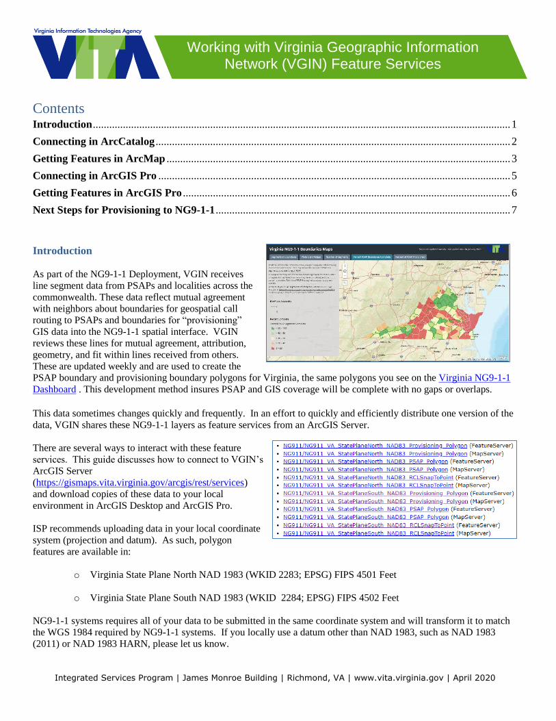
Introduction
As part of the NG9-1-1 Deployment, VGIN receives
line segment data from PSAPs and localities across the
commonwealth. These data reflect mutual agreement
with neighbors about boundaries for geospatial call
routing to PSAPs and boundaries for “provisioning”
GIS data into the NG9-1-1 spatial interface. VGIN
reviews these lines for mutual agreement, attribution,
geometry, and fit within lines received from others.
These are updated weekly and are used to create the
PSAP boundary and provisioning boundary polygons for Virginia, the same polygons you see on the Virginia NG9-1-1
Dashboard . This development method insures PSAP and GIS coverage will be complete with no gaps or overlaps.
This data sometimes changes quickly and frequently. In an effort to quickly and efficiently distribute one version of the
data, VGIN shares these NG9-1-1 layers as feature services from an ArcGIS Server.
There are several ways to interact with these feature
services. This guide discusses how to connect to VGIN’s
ArcGIS Server
(https://gismaps.vita.virginia.gov/arcgis/rest/services)
and download copies of these data to your local
environment in ArcGIS Desktop and ArcGIS Pro.
ISP recommends uploading data in your local coordinate
system (projection and datum). As such, polygon
features are available in:
o Virginia State Plane North NAD 1983 (WKID 2283; EPSG) FIPS 4501 Feet
o Virginia State Plane South NAD 1983 (WKID 2284; EPSG) FIPS 4502 Feet
NG9-1-1 systems requires all of your data to be submitted in the same coordinate system and will transform it to match
the WGS 1984 required by NG9-1-1 systems. If you locally use a datum other than NAD 1983, such as NAD 1983
(2011) or NAD 1983 HARN, please let us know.
Working with Virginia Geographic Information Network (VGIN) Feature Services
P a g e | 2
Integrated Services Program | James Monroe Building | Richmond, VA | www.vita.virginia.gov | April 2020
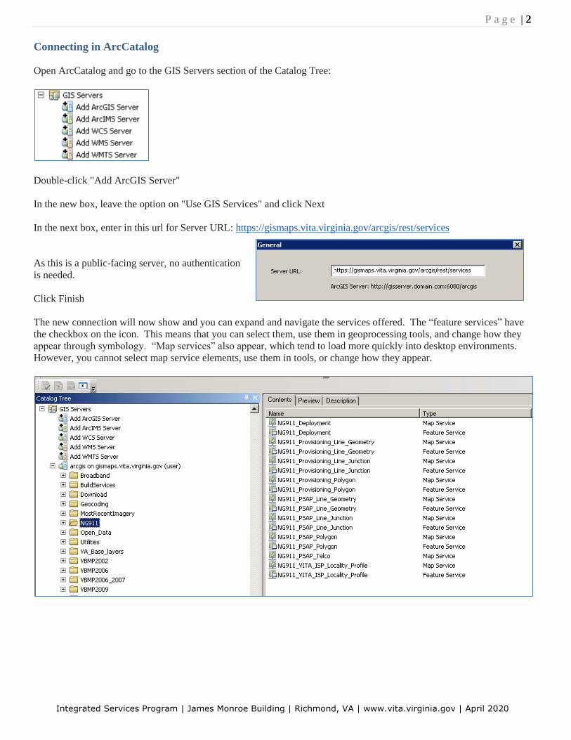
Connecting in ArcCatalog
Open ArcCatalog and go to the GIS Servers section of the Catalog Tree:
Double-click "Add ArcGIS Server"
In the new box, leave the option on "Use GIS Services" and click Next
In the next box, enter in this url for Server URL: https://gismaps.vita.virginia.gov/arcgis/rest/services
As this is a public-facing server, no authentication
is needed.
Click Finish
The new connection will now show and you can expand and navigate the services offered. The “feature services” have
the checkbox on the icon. This means that you can select them, use them in geoprocessing tools, and change how they
appear through symbology. “Map services” also appear, which tend to load more quickly into desktop environments.
However, you cannot select map service elements, use them in tools, or change how they appear.
P a g e | 3
Integrated Services Program | James Monroe Building | Richmond, VA | www.vita.virginia.gov | April 2020
Getting Features in ArcMap
Using ArcMap, there are two main ways to turn feature services in to a locally stored file geodatabase or a
shapefile copy on your C:\ drive or network drive.
The first choice you have is if you want to extract the whole dataset, or only a selection of the dataset. If you
want the whole dataset, skip to the next paragraph. If you only want a few features, select them interactively
or based on another feature so they show up in bright blue. When you move to the next steps, only these
features will be copied.
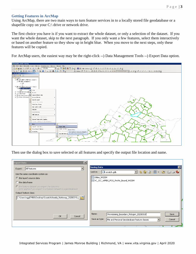
For ArcMap users, the easiest way may be the right-click --) Data Management Tools --) Export Data option.
Then use the dialog box to save selected or all features and specify the output file location and name.

P a g e | 4
Integrated Services Program | James Monroe Building | Richmond, VA | www.vita.virginia.gov | April 2020
The CopyFeatures geoprocessing tool is also available.
In ArcToolbox, look under Data Management --) Features --) Copy Features.
From the Python window, start with arcpy.CopyFeatures_management.
P a g e | 5
Integrated Services Program | James Monroe Building | Richmond, VA | www.vita.virginia.gov | April 2020
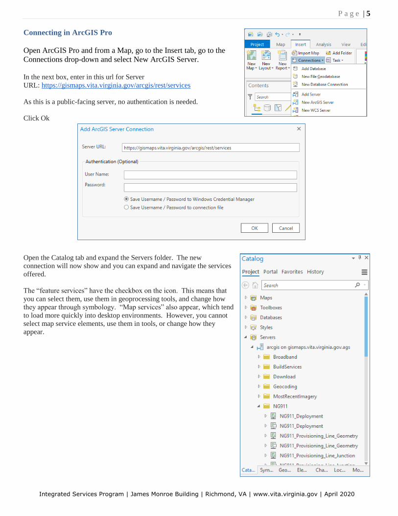
Connecting in ArcGIS Pro
Open ArcGIS Pro and from a Map, go to the Insert tab, go to the
Connections drop-down and select New ArcGIS Server.
In the next box, enter in this url for Server
URL: https://gismaps.vita.virginia.gov/arcgis/rest/services
As this is a public-facing server, no authentication is needed.
Click Ok
Open the Catalog tab and expand the Servers folder. The new
connection will now show and you can expand and navigate the services
offered.
The “feature services” have the checkbox on the icon. This means that
you can select them, use them in geoprocessing tools, and change how
they appear through symbology. “Map services” also appear, which tend
to load more quickly into desktop environments. However, you cannot
select map service elements, use them in tools, or change how they
appear.
P a g e | 6
Integrated Services Program | James Monroe Building | Richmond, VA | www.vita.virginia.gov | April 2020
Getting Features in ArcGIS Pro
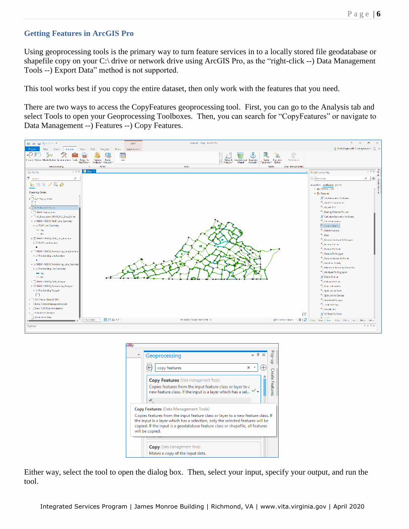
Using geoprocessing tools is the primary way to turn feature services in to a locally stored file geodatabase or
shapefile copy on your C:\ drive or network drive using ArcGIS Pro, as the “right-click --) Data Management
Tools --) Export Data” method is not supported.
This tool works best if you copy the entire dataset, then only work with the features that you need.
There are two ways to access the CopyFeatures geoprocessing tool. First, you can go to the Analysis tab and
select Tools to open your Geoprocessing Toolboxes. Then, you can search for “CopyFeatures” or navigate to
Data Management --) Features --) Copy Features.
Either way, select the tool to open the dialog box. Then, select your input, specify your output, and run the
tool.
P a g e | 7
Integrated Services Program | James Monroe Building | Richmond, VA | www.vita.virginia.gov | April 2020
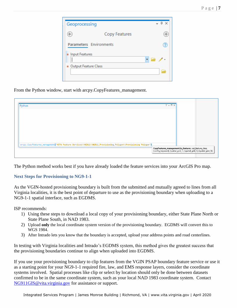
From the Python window, start with arcpy.CopyFeatures_management.
The Python method works best if you have already loaded the feature services into your ArcGIS Pro map.
Next Steps for Provisioning to NG9-1-1
As the VGIN-hosted provisioning boundary is built from the submitted and mutually agreed to lines from all
Virginia localities, it is the best point of departure to use as the provisioning boundary when uploading to a
NG9-1-1 spatial interface, such as EGDMS.
ISP recommends:
1) Using these steps to download a local copy of your provisioning boundary, either State Plane North or
State Plane South, in NAD 1983.
2) Upload only the local coordinate system version of the provisioning boundary. EGDMS will convert this to
WGS 1984. 3) After Intrado lets you know that the boundary is accepted, upload your address points and road centerlines.
In testing with Virginia localities and Intrado’s EGDMS system, this method gives the greatest success that
the provisioning boundaries continue to align when uploaded into EGDMS.
If you use your provisioning boundary to clip features from the VGIN PSAP boundary feature service or use it
as a starting point for your NG9-1-1 required fire, law, and EMS response layers, consider the coordinate
systems involved. Spatial processes like clip or select by location should only be done between datasets
confirmed to be in the same coordinate system, such as your local NAD 1983 coordinate system. Contact
[email protected] for assistance or support.