Embed Size (px)
Citation preview

Working The Stones Of BranscombeFrom Flint-Knappers To Pebble-Pickers
John Torrance
Until the 20th century this was a relatively self-sufficient community. By exploiting the natural environment they created a landscape. These were some of their resources:
The red line shows what I'm going to talk about: the extraction of minerals, and the labour and knowledge involved in that.
So what was there to extract? Geology has the answer. Branscombe has a considerable but not exceptional variety of mineral resources – no metals, for instance. No coal. No stone suitable for millstones — the stones at Manor Mill came from Derbyshire and France. In the 14th century millstones were apparently brought by sea from Wales via Bridgwater and the river Parrett and by wagon from Dinnington near Crewkerne.
This map shows the surface geology, what would be exposed if the vegetation and topsoil were removed. On the high ground, brown is a layer of brown clay full of flints, debris left behind by layers of chalk which have eroded away. This forms the subsoil of the high flat fields around the village.
LAND SURFACE(VEGETATION, ANIMALS)
wood, hunting, agriculture, domestic animals for food and carrying.
EXTRACTION (MINERALS)
stone, sand, clay, etc.
(Traded in) iron, coal, oil,millstones, etc.
SEA
fish, seaweed
salt
Surface geologySurface geology
SURFACE GEOLOGY
LOGO

In the valley bottoms, mauve is alluvium — gravel, sand and soil washed down by the streams. The streams have carved out the three valleys which give Branscombe its characteristic shape, as seen in the old contour map, from which was taken the Project’s logo. The valley slopes cut down through layers beneath the clay and expose the underlying rocks: green is upper greensand, a kind of sandstone. Red is red mudstone. Quarries (black-and white diagonals) show that chalk is hidden beneath the clay-with-flints.
This solid geology map above shows the underlying bedrock, with the surface layers of clay and alluvium removed. Three layers:1. Red: the oldest, at base, is red mudstone or Keuper marl2. Green: on top of that, sandstones of the Upper Greensand formation 3. Whitish: on top of that, a cap of chalk
These are sedimentary rocks, laid down in prehistoric seas.
SOLIDGEOLOGY
KEUPER MARL (RED MUDSTONE)
CHALK
GREENSAND

The three layers are exposed in the cliffs. The red mudstone to the west (top of picture) dips under the sea after Branscombe Mouth. Sandstone takes over, with thickening chalk above. After the Hooken landslip (in foreground) the sandstone dips under the sea, and at Beer Head (off picture, lower right) the cliffs are entirely of chalk.
Above is a cliff section from Ramues Gallois’s and Ian West’s fine website on the geology of E. Devon, which shows this. For a clearer image visit the webpage at http://www.soton.ac.uk/~imw/jpg-Beer/6BR-cliff-section-general.jpg The reason the strata all dip towards the east at Branscombe is because of faults at Beer. These have caused the bedrock to sink, producing a chalk landscape at Beer. But Branscombe has a mixed landscape.
The Triassic Red Mudstone is over 200m years old, laid down when Branscombe was roughly where the Sahara desert is now. (The next era, the Jurassic, is not represented at Branscombe because it was then dry land.) The Upper Greensand is about 135m years old and the chalk dates from about 100m to 65m years ago.
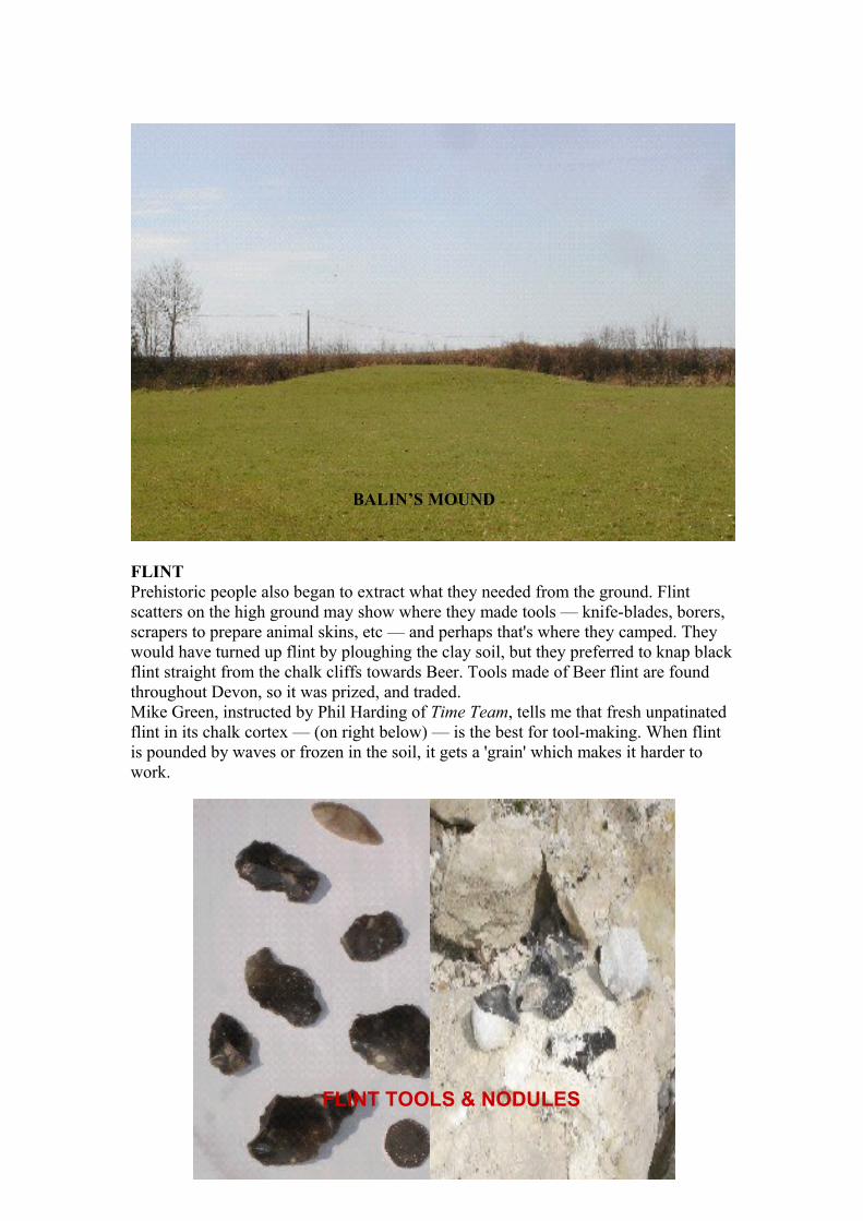
The first people to settle at Branscombe were Neolithic and Early Bronze Age people, a mere 4000 years ago. They only scratched the surface of the landscape. They hunted and domesticated animals, cleared forests, ploughed and planted crops, made houses for themselves and for the dead. This burial mound at Bovey Fir was probably some 3000 years old when the Saxons used it to mark the parish boundary between Branscombe and Beer, coming south from the Hangman Stone.Later a windmill stood on it until it was blown down in the 19th century.
cliff section
FLINTPrehistoric people also began to extract what they needed from the ground. Flint scatters on the high ground may show where they made tools — knife-blades, borers, scrapers to prepare animal skins, etc — and perhaps that's where they camped. They would have turned up flint by ploughing the clay soil, but they preferred to knap black flint straight from the chalk cliffs towards Beer. Tools made of Beer flint are found throughout Devon, so it was prized, and traded.Mike Green, instructed by Phil Harding of Time Team, tells me that fresh unpatinated flint in its chalk cortex — (on right below) — is the best for tool-making. When flint is pounded by waves or frozen in the soil, it gets a 'grain' which makes it harder to work.
BALIN’S MOUND
FLINT TOOLS & NODULES

CHERTFlint is the result of micro-crystals of silica consolidating in cavities in chalk. When the same thing happens in sandstone the result is chert, a similar rock but less hard and usually brown in colour. Branscombe sandstone contains large blocks and seams of chert, and it has been used for building.Prehistoric people didn’t rate it as highly as flint for tools and weapons, because it was harder to work and less durable. But this fine chert axe-head, about 5” long, belonging to Angela Lambert, was found in the stream in the valley below Hole House. It is unusually dark. It may have been made more for ceremonial than practical purposes, and appears to be unfinished.
CLAYThe clay with flints on the hilltops was not of much practical use, but prehistoric people could have found pockets of flint-free red clay in the valleys, and would probably have used it to make pots. There is no prehistoric pottery from Branscombe at Exeter Museum, but Orlando Hutchinson drew a picture of a potsherd from a burial at Watercombe, probably late Neolithic or Bronze Age.Since Saxon times at least, if not earlier, clay was combined with mud, sand and straw to make cob walls. At first all the village houses were built of timber and cob, not stone.

There’s not much cob left in Branscombe now. This cob wall at Berry Barton may be several hundred years old.
SANDSTONEThe Romans quarried stone at Beer and they built in stone at Seaton, but so far as we know there were no Roman buildings in Branscombe. The Saxons were probably the first people to build in stone here, when they built the first church, about 1000 AD. This is part of the north wall of the nave, where a little bit of Saxon stonework has been labelled, on the left; it’s what is called ‘long and short work’.
Quarrying for sandstone may have started then, to build the first church, and the first sandstone quarry may be the one just across the road. In the early 20th century, it held allotments, then an egg-packing station, now houses. The quarry continues to the east, behind Church Living, as can be seen on the map.
SANDSTONE QUARRY
QUARRY BEHIND CHURCH LIVING

Another view of the quarry. English Heritage say the present church, which was built in the 12th and 13th centuries, is built of Salcombe stone, so not from this quarry.Salcombe sandstone is similar to Branscombe sandstone but of better quality for building.
In the 1200s this house — Church Cottage — was built opposite the church by the Dean and Chapter of Exeter Cathedral. They owned the manor, and the canons of Exeter used this building. Church Living farmhouse next door was built in the 1400s on the site of what had been the medieval manor house, where the Dean and Chapter’s steward lived.The position of the cottage in front of the quarry shows that the quarry was already there when it was built, perhaps at about the same time as the church. Its back wall is of roughly dressed sandstone, like the church, possibly also from Salcombe Regis. The accounts for rebuilding Exeter Cathedral 1279-1353 show that two main sources of stone were Beer, for chalk freestone that could be carved for the traceries of roof and windows, and Salcombe Regis for sandstone for walls.
QUARRY

But Branscombe supplied stone for the cathedral too. This is an entry from 1341, a few years before the Black Death. On can imagine the heavy labour involved. One 'tontight' in the boat equals one cartload on land. La Sege was either Topsham or Countess Wear. Where was the quarry in Branscombe? The carriage cost there was a sixth of the cost from La Sege, which is 4 or 5 miles from the cathedral, so the quarry can't have been much more than three quarters of a mile from the sea at Branscombe. This rules out some stone quarries, but would include, for example:
. . . this one, on Castle Hill. Trying to tell the age of a quarry is like trying to tell the age of an actress. (I think this is also the one where, according to Brian Dowell, Clem Ford used to blow out sand with dynamite for building purposes.)I've suggested that stone for the church was quarried, at first, from the nearest suitable place, and this was true of many old farms at Branscombe. The farms were built in sheltered positions on the slopes, near spring-lines which occur where the porous sandstone rests on the impermeable red clay. And further up the hillside above each farm there's usually an old sandstone quarry, from which it was built.
REAR WALL
CHURCH COTTAGE
REAR WALL
17 tontight of stones from Branscombe bought from J. Stone 14s 2d, 10d each tontight. In carriage of the same stones from the quarry to the sea 2s 10d. For loading a boat 2s 10d. In carriage of the same stones by sea to 'La Sege' 17s. For unloading the boat at 'La Sege' 13d. 17 cartloads from 'la Sege' to Exeter 12s.6d, 9d a cartload.
From fabric accounts of Exeter Cathedral, 1341

The first private house to be built of stone would have been Edge Barton. In the Middle Ages it was the home of the Branscombe and Wadham families, who were the local gentry. What you see here is Elizabethan, or later, and faced with Beer stone, but there is 13th century stonework in the house. Behind are the old sandstone quarries in the hillside nearby from which much of the house was probably built. All the old sandstone quarries are now overgrown. They appear to have 'gone back to nature' but they are really cultural sites with natural ecosystems adapted to their unnatural forms.Already by the 14th century there were farmhouses at Berry, Hole, Culverwell, Rockenhayne, Watercombe, Barnells, Seaside and elsewhere, already known by similar names, but probably built of cob. The present stone-built farmhouses mostly date from the 16th,17th or 18th centuries.
CASTLE HILL SANDSTONE QUARRY
EDGE BARTON

At Branscombe, unlike Salcombe Regis, the sandstone often contains thick veins of chert, and houses often repeat this pattern, with chert blocks in the stone courses, as here at Great Seaside Farm. Much of the sandstone wasn't good enough to cut and dress, so houses, cottages and outbuildings were often built of sandstone and chert rubble with dressed cornerstones, often of Beer stone, as here.The Vicarage, built in 1884, and Eastcotte, the Edwardian house nearby, were both, like Great Seaside, built of sandstone from Stockham's Hill directly above, and they are well built of dressed stone. All three houses show reddish coloration from iron oxide characteristic of the stone from this hillside, where there used to be a field called Redpit.
VICARAGE
EASTCOTTEGREAT SEASIDE
GYPSUM

GYPSUMAnother mineral that Branscombe contributed to Exeter Cathedral was gypsum. The Fabric Accounts about 1330 show plaster of Paris coming from Salcombe Regis and Beer. It must have been made from gypsum seams in in the red mudstone cliffs, which appear both at Little Weston, just in Salcombe parish, and at Branscombe. The cathedral accounts show there was a lime kiln at Beer in the 14th century, so perhaps local lime-burning skills were adapted to burn Branscombe gypsum to make plaster of Paris.Plaster of 'Pallis', as it was called, was bought from Branscombe for work in Woodbury church 200 years later, in 1618 and 1640 (Gill Selley).
John Stuckey’s grand house at Weston was burnt down in the 1820s. The Rev. John Swete tells us that Stuckey was quarrying and selling gypsum in the 1790s for plastering ceilings and cornices in Sidmouth, and no doubt he used it himself when he built this house. In 1808 Charles Vancouver wrote that Branscombe gypsum was 'much in demand for stucco and fine mason-work, and usually sold for about 2s 6d per hundredweight'. This was the Regency period, stucco rendering was in fashion. After Stuckey died in 1810 the industry was carried on by Exeter merchants.
Sue Dymond has spoken to us about an attempt by William Wheaton of Exeter to mine and grind up gypsum in this mill, built on Branscombe beach in 1855. Branscombe gypsum was not plentiful or pure enough to compete for long in the plaster of Paris market, and Wheaton, who had an artificial fertilizer factory at Ebdon, in Woodbury parish, sold ground gypsum as a manure. It contains calcium sulphate and other trace elements.
FACADE OF JOHN STUCKEY’S HOUSE AT WESTON

WILLIAM WHEATON’S GYPSUM MILL 1855
Sue Dymond also drew my attention to this reference in Orlando Hutchinson's diary. In 1851 — just before Wheaton built his gypsum mill — Hutchinson picked up some gypsum on Weston beach, 'which a lad told me the common people call "spear".' The old English name for gypsum and other crystalline rocks is 'spar', and this local version of it — 'spear' —may have been used in Branscombe for a very long time.
WILLIAM WHEATON’S GYPSUM MILL 1855
PETER ORLANDO HUTCHINSON’SDIARY 1851

SALT. The shingle banks which nearly closed the mouths of the rivers Otter, Sid and Axe were built up between the 14th and 16th centuries by storms during the ‘Little Ice Age’, when the climate deteriorated for about 400 years. There were salt-pans in the rivers before that, as names like Budleigh Salterton and Salcombe Regis show. Branscombe would have had a small tidal estuary and salt marsh where the beach car park is, and might have had salt-pans too. Southern Brittany is the furthest north that sea-salt can be obtained just by evaporation. In Devon salt-pans were used for evaporation up to a point, then the concentrated brine was scooped out and boiled dry in shallow containers over a fire to form salt crystals.A record of 1278 shows that John Walrond of Bovey House acquired a house and land at Celer — Seller's Wood, which belonged to the Bovey estate from then until 1868. The name Sellers Wood may contain the French word sel for salt, and has also been related to salarium, a fish-curing shed.
SALT PANS IN BRITTANY

CHALKThe biggest and most numerous diggings at Branscombe were for chalk. Chalk was quarried to make lime, and the quarries date from the heyday of lime-burning, roughly from 1750 to 1860. The map shows them as bites out of the chalk bedrock above Woodhouse and Gays.This was a period of urban growth and building, and lime was in demand for mortar until the introduction of Portland cement in the 19th century, which used much less lime and made a tougher bond. It was also a period of agricultural improvement, when the need to spread lime on the land, especially on acid and heavy soils, became generally recognised and required by farm leases.

Here is the John Swete's drawing of a lime quarry and kiln at Branscombe in 1795. Where was it?
LIME KILN by JOHN SWETE 1795

In his diary Swete describes riding in his carriage, with his wife and daughter, from Beer, and how he found the quarry after losing his way. This old OS map of 1807, copied for me by Phil Planel, shows a lime kiln in a quarry on Stockham’s Hill above Hazelwood, and I think this may be what he painted, having failed to turn down Vicarage Lane and continued over what is now a field but was then a busy track.
And here is the quarry today.
CHALK QUARRY ON STOCKHAM’S HILL
LIME KILN, GAYS FARM
LIME KILN, WOODHOUSE FARM

The chalk at Beer and Branscombe gave them a near monopoly of lime production in this corner of East Devon, but there was no coal to burn it with. So small coal (culm) for the lime-kilns had to be shipped from South Wales, around Land's End, and landed on the beach at Weston Mouth and Branscombe Mouth. This was the coalyard built by the Fords of Gays Farm and later Lower House (Eastcombe). It’s now part of the Sea Shanty tearooms.
A good deal is known about these lime-burning families. The Fords were the most successful. In the 19th century John Ford expanded the business to Beer and worked the lime quarry opposite the stone quarry caves. John Scott tells me that in the 1880s Henry Ford (John’s grandson) held an explosives license, and chalk for burning was blasted out of Beer Quarry by his successors until quite recently. It seems likely that explosives were used at Branscombe too before 1880 (by which time the chalk quarries here were unprofitable) so blasting would have added to the racket of carting the chalk, and to the clouds of white dust on the lanes and hedges.
COALYARD BUILT BY FORD FAMILY

The East Devon lime industry declined for various reasons in the C20 but lingered on with Government subsidies at Beer until about 1980. This photo from the 1950s 0r 1960s, copied for me by John Scott, shows old lime kilns behind the newer ones.
John Ford 1771 - 1865 Henry Ford 1839 - 1908
BEER LIME QUARRY

FLINT AGAINFlint, used by the very first settlers in Branscombe, continued to be used — to build walls, farm buildings, sometimes houses. Around 1600 a fashion appeared in East Devon for smart house-walls of knapped flint and stone chequerwork. The only good example in Branscombe is this wall at Hole House, but others are ...
FLINT WALL AT HOLE HOUSE
Great House, Colyton

... and most spectacularly, at Cadhay.
Flint became a marketable commodity in the 18th century with the invention of the flintlock musket, which became the main weapon of European armies after 1660. Canon Milles wrote, around 1750, that the black flints removed from the chalk by lime-burners on Berry Cliff were 'esteemed very good to be cutt for guns'. Orlando Hutchinson records that when walking the undercliff between Branscombe and Beer as a boy (perhaps about 1825) he came across piles of flint flakes left there by flint-knappers working for the gun trade. This came to an end soon afterwards, for the invention of the percussion cap in 1840 made flintlocks obsolete.
FLINTLOCK MECHANISM

The unwanted flint and sandstone in the old quarries were used for roadstone for farm tracks and village roads. Here oral history populates the story with voices from living memory. Horace Pike, talking to Barbara in the 1990s:H: Up the top of Culverwell, you go through the cross gate, and ... years ago, they used to bring the stones out of the quarry which is up that wheel track ... They used to bring it down there, an' this old man, I don' know who 'e was, used to 'ave a piece o' stick with a fork on the end and a 'ammer and he used to crack the stones, And the stones 'ad to be of a certain size. And that was what the fork was — that was the width of the stone. 'E used to 'aul 'em down and crack. Crack, haul 'em down and crack, crack, and then pack 'em up ... in a cube, 'e used to pack 'is stones in a square lump. And we kids went up — aargh, lovely, undone all the lump an' of course all the stones went all ways! B: Were these flints?H: Well, some were flint, depending what 'e wanted. The under one was flint, the one above was sandstone.B: And what would that have been used for?H: The roads. Used to get cart track and they'd fill 'em up with flint stones of a certain size, see, an' then 'e put the sandstones on top o' that, and then have the steam roller, and then they'd put the sand on top o' that. They roll it all in and then used to go down 'ard, dinnum?
CULVERWELL QUARRY

CLAY AGAINClay, also used in prehistoric times, continued to be used in many ways — in cob walls, for instance. The soft red marl that can be found in the mudstone in the valley sides was also used as a soil-conditioner, often mixed with lime or dung. In Beer quarry caves hard hats with a candle-holder were once made of this clay, baked on the lime-kilns. Elijah Chick said told that a stolen duck roasted on a lime-kiln was all the better for being encased in clay.This clay-pit near Hill Arrish yields a smooth reddish clay. Another clay-pit was behind Manor Mill, and Ron Denning who farmed there remembers that it was 'like plasticine'.
CLAY-PIT AT HILL ARRISH

Frank Chard, whose father farmed at Great Seaside in the 1930s, remembers his father bringing clay from the pit by Manor Mill to repair the clay lining of the leat that ran from near the Mill to the beach, to generate electricity for the Sea Shanty café. Water voles had made holes in it. The leat was first dug in 1855 to power Wheaton's gypsum-mill, so the same clay was probably used to line it then. The claypit and leat are now filled in.Were bricks ever made of Branscombe clay? When John Stuckey died in 1810, the inventory of his possessions at Weston included 5,000 bricks and there was a field at Weston called Brick Field. But apart from that we've found no clear evidence of brickmaking here. The nearest brickworks was probably one which is shown in the valley between Beer and Seaton, south of Couchill farm, on the 1888 OS map.
Beach pebbles were exploited at Branscombe and Seaton in the 20th century as grinders in rotary mills. In 1911 Edward Johnson of Seaton (British Flint and Pebble Co.) applied to John Ford, as owner of Branscombe beach, to collect 300 tons of pebbles. Ford got the royalties.The pebbles were sold to cement works, for grinding the clinker from their kilns into powdered cement, and also to the paint trade, for grinding pigments. William Gush, a fisherman, was Johnson's foreman at Branscombe. He and his sons and one or two friends were paid 4d a hundredweight for the pebbles they collected. Pebbles had to be 'picked for rotundity', without 'elongated or pear-shaped flints', and
LEAT

firms ordered different sizes, graded from 1 to 6. They were taken to Seaton station in hundredweight bags, six or seven tons at a time, in Gush's fishing-boat, Johnson's son was a strict but kindly manager, who gave the Gush family twelve pounds of beef at Christmas, and legs of lamb to the other pickers. He gave a trial to an unsatisfactory picker because, he said, 'I like to think that this business is a stand-by for the poor population of the village'. But he and some of the pickers were called up in 1914 and the business lapsed. In 1916 John Ford, Henry Ford's son, bought the company cheaply, and after the war he expanded it again, with a motor boat and storage shed at Seaton. But it had ceased trading by 1939.
In 1939 John Ford's brother Clem, who had opened the Sea Shanty beach café at Branscombe, arranged for Heath & Son of Burslem to send their own pebble-pickers to Branscombe, paying royalties of 5/- per ton to the Fords as owners of the beach. They calcined the pebbles to supply silica to Staffordshire pottery firms, for glazing. The second World War closed the beach, barricaded against invasion. Heath & Son resumed picking in 1944 for a while, but in 1948 Clem Ford set up a new company with Edward Beken of Seaton, called Pebbles and Flints Ltd. Small pebbles were collected for grinding, larger ones as cobbles, for ornamental pavements. Beken went on after Clem Ford died in 1961, and Beer fishermen like Alan Westlake remember pebble-picking as a winter standby. Pebble-picking ceased by the 'seventies, and now the National Trust, which took over the beach when Clem Ford died, forbids the removal of pebbles.
PEBBLE MILL
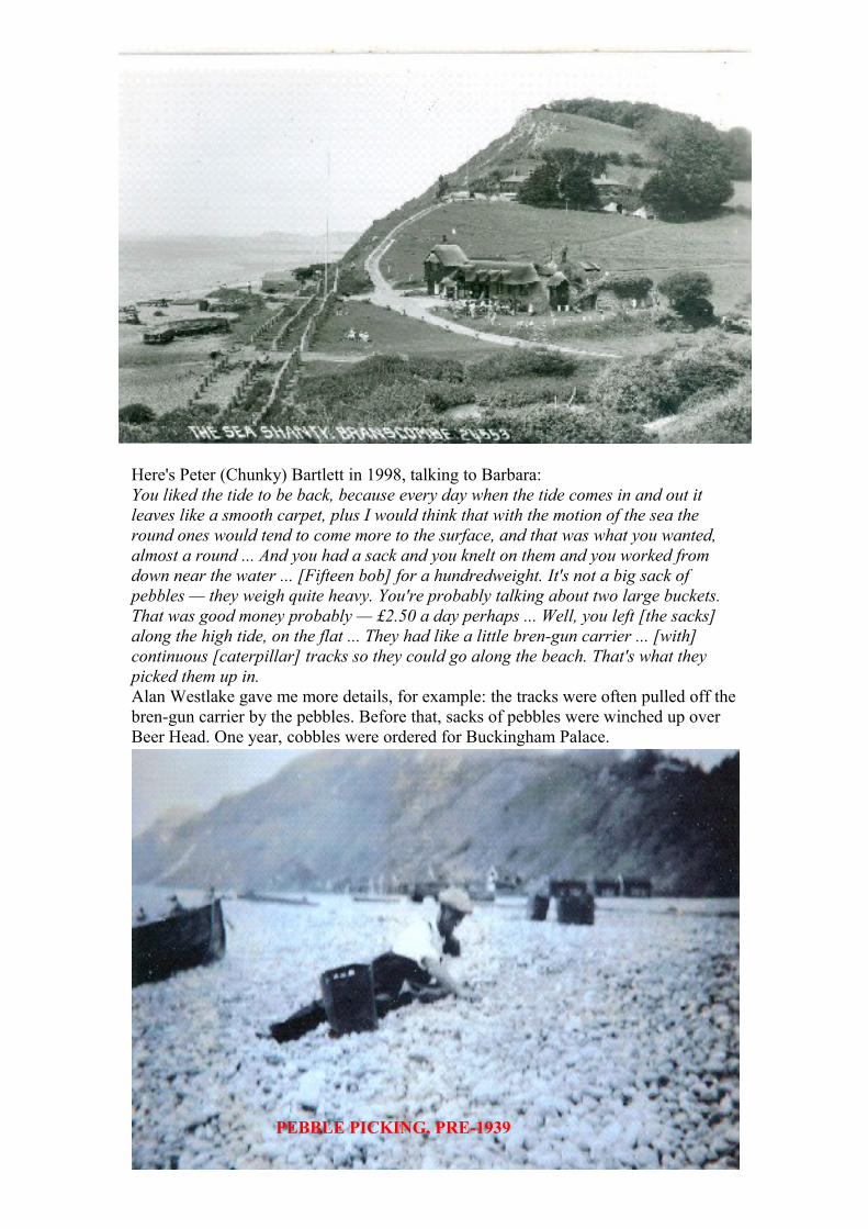
Here's Peter (Chunky) Bartlett in 1998, talking to Barbara:You liked the tide to be back, because every day when the tide comes in and out it leaves like a smooth carpet, plus I would think that with the motion of the sea the round ones would tend to come more to the surface, and that was what you wanted, almost a round ... And you had a sack and you knelt on them and you worked from down near the water ... [Fifteen bob] for a hundredweight. It's not a big sack of pebbles — they weigh quite heavy. You're probably talking about two large buckets. That was good money probably — £2.50 a day perhaps ... Well, you left [the sacks] along the high tide, on the flat ... They had like a little bren-gun carrier ... [with] continuous [caterpillar] tracks so they could go along the beach. That's what they picked them up in.Alan Westlake gave me more details, for example: the tracks were often pulled off the bren-gun carrier by the pebbles. Before that, sacks of pebbles were winched up over Beer Head. One year, cobbles were ordered for Buckingham Palace.
PEBBLE PICKING, PRE-1939

So: flint, chert, clay, salt, stone, gypsum, chalk, pebbles. Branscombe people have found many ways of using them or making a living from them over the centuries. Some of their labour has left no trace, and where it has, the traces are mostly hidden by trees and scrub and grass. But we shouldn't forget all that hard work and ingenuity, and the passing-on of landscape knowledge and knowhow. When we casually view what may just look like a pretty bit of scenery, these are, and should be, humbling thoughts.
With thanks for images and permissions:
The Branscombe Project, Ros Byam-Shaw, Sue Dymond, Ramues Gallois, Mike Green, Angela Lambert, Phil Planel, Sylvan Robinson, John
Scott, Geoff Squire, Hilary Walford-Howell, Ian West, Andy Wilcox,
Ross Willmington, Wikipedia.