Embed Size (px)
Citation preview

1
Working Paper No. 359
The Role of Waterways in Promoting
Urban Resilience: The Case of Kochi City
Zeba Aziz
Indro Ray
Sandeep Paul
May 2018
INDIAN COUNCIL FOR RESEARCH ON INTERNATIONAL ECONOMIC RELATIONS

Table of Contents
Abstract ...................................................................................................................................... i
Acknowledgement .................................................................................................................... ii
1. Introduction ........................................................................................................................ 3
2. Kochi ................................................................................................................................... 3
3. Global best practices for waterways development .......................................................... 6
4. Waterways for increased resilience ................................................................................ 10
5. Waterways as an alternate transport system in Kochi ................................................. 12
6. Limitations and Challenges to development of water ways in Kochi ......................... 17
7. Conclusion ........................................................................................................................ 18
References ............................................................................................................................... 20
List of Figures
Figure 1: Map showing the setting of Kochi city within the context of Vembanad Lake 5
Figure 2: Approximate travel to work radius for Kochi’s working population .............. 12
Figure 3: Mode choice in commuting for work............................................................... 13
Figure 4: Kochi’s key employment hubs and road and ferry connectivity ..................... 14
Figure 5: Connectivity in Kochi City .............................................................................. 15
Figure 6: Phase 1 of Kochi metro project operating since 2017 & Phase 1 & 2 of
proposed Kochi water metro project. ............................................................... 16

i
Abstract
Coastal cities around the world are locales of high vulnerability. The issues are graver in the
developing world where the challenges posed by the urbanisation and climate change
multiply the existing risks. Here, we examine the case of Kochi, an Indian city located at the
centre of a rapidly urbanizing coastal and estuarine region. In Kochi, a port city characterised
by crisscrossing canals and rivers connected to a backwater system, waterways used to play a
major role in the socio-economic and cultural development of the region. They not only
supported the commerce and economy but also connected communities, supported a rich and
diverse ecosystem and provided livelihood opportunities. However, poor planning and
management of the industrialization and urbanization processes resulted in the neglect and
widespread exploitation of this resource over the years, undermining its ability to support
both ecology and connectivity. In the recent years, partly due to growing recognition of
climate change, and need for both mitigation and adaptation, there has been a renewed
interest in investing in waterways to enhance connectivity in the region. The study examines
how water ways can promote the climate, social and economic resilience of the city. It also
critically compares these efforts against the global experiences and attempts to identify
multiple limitations and challenges to development of water ways in Kochi. The global
experiences could be useful for Kochi as it is now starting to focus on waterways
development as a crucial part of its integrated transportation network.
________
Keywords: Inland waterways, Resilience, Kochi, Climate change
JEL Classification: R40, R42, R58, Q25
Author’s email: [email protected], [email protected], [email protected]
_________
Disclaimer: Opinions and recommendations in the report are exclusively of the author(s) and
not of any other individual or institution including ICRIER. This report has been prepared in
good faith on the basis of information available at the date of publication. All interactions
and transactions with industry sponsors and their representatives have been transparent and
conducted in an open, honest and independent manner as enshrined in ICRIER Memorandum
of Association. ICRIER does not accept any corporate funding that comes with a mandated
research area which is not in line with ICRIER’s research agenda. The corporate funding of
an ICRIER activity does not, in any way, imply ICRIER’s endorsement of the views of the
sponsoring organization or its products or policies. ICRIER does not conduct research that is
focused on any specific product or service provided by the corporate sponsor.
ii
Acknowledgement
This paper is part of a research project undertaken at ICRIER as a part of ‘An Institutional
Exploration of Urban Competitiveness and Climate Adaptation through Two Sectoral Lenses
– Water Sector’ project supported by Rockefeller Foundation. Authors would like to thank
Dr. Meenu Tewari, for her continued guidance and important suggestions during work on the
paper. The study has greatly benefitted from the previous works at ICRIER on the theme of
climate change and competitiveness of cities and in particular the study on climate change
risks for transport systems of Kochi undertaken in collaboration with Centre for Public Policy
Research. We are also extremely grateful to Mr. GK Bhat and Ms. Divya Sharma for their
valuable comments and suggestions.
3
The Role of Waterways in Promoting Urban Resilience: The Case of Kochi City
Zeba Aziz, Indro Ray, Sandeep Paul
1. Introduction
The battle on climate change is increasingly becoming local. As climate policy is shifting
away from its centralised, top down approaches, climate action is increasingly shifting to the
cities – the nodes of economic growth. The consensus is that sub-national governments have
a crucial role to play especially in adaptation as they have better knowledge of locale specific
vulnerabilities and are better placed to bring together civil society and communities for
collective action. As per the IPCC fifth assessment report (IPCC,2014) “In urban areas
climate change is projected to increase risks for people, assets, economies and ecosystems,
including risks from heat stress, storms and extreme precipitation, inland and coastal
flooding, landslides, air pollution, drought, water scarcity, sea level rise and storm surges
(very high confidence). These risks are amplified for those lacking essential infrastructure
and services or living in exposed areas”.
This is particularly true of cities in the developing world, which are highly inequitable in
terms of access to resources and service coverage, densely populated and lack even basic
urban infrastructure. The development of most of these cities has been haphazard with little
planning, severely endangering the ecosystems they are placed in. In this respect, it is
important to understand the resilience of these cities to the risks arising out of climate change.
The issue is more serious in coastal/riverine cities that are often more vulnerable to climate
change than others. The fact that till recently, there was very little attention to urban water
bodies and wetlands exasperates the problem. For example In India the approach to urban
planning has been land centric with very little acknowledgement for water bodies or
wetlands. Shah (2016) has noted that there is no specific legislation in India to protect water
bodies. The laws in place like Wetlands (Conservation and Management) Rules, 2010 has left
out most of the urban water bodies, causing the cities to grow over the water bodies and its
functional parts (shah, 2016). It is in this background that we explore the role of waterways in
the resilience paradigm of an urban space- city of Kochi in this case.
2. Kochi
Coastal cities around the world have played a pivotal role in the history of civilisation, as
centres of global trade and commerce, of cultural exchanges, of vibrant local economies and
of rapid growth and transformation. Like many of its counterparts around the world, the city
of Kochi, located along India’s Western coast, enjoys a strategic location, and has always
been sought-after by nations looking to dominate in the area. Through the numerous waves of
colonisation (the Portuguese in the sixteenth century, the Dutch and the British in the
nineteenth century), the city flourished as a port, gaining in both economic prowess and
population. The port city, Fort Kochi, became a municipality during this period, responding
to the need for planning and governance in the growing city.

4
Today, with a population of over 600,000, Kochi is the largest city in the south Indian state of
Kerala and the second largest along India’s western coastline, after Mumbai. The city has
extended from the erstwhile Fort Kochi to areas in the east, including Mattancherry and
Ernakulam. It is part of a rapidly growing contiguous urban region comprising seven other
cities and forty-five census towns, and a population that has doubled in the past decade to two
million, making it one of the fastest growing urban hubs in the country (GOI, 2011).
In addition to being the most populated city in the state, Kochi is also the regional economic
hub. Ernakulam district, within which the city lies, is the largest contributor to the state’s
gross domestic product and has the highest share of industrial units in the state.1 More
recently, Kochi has seen an increase in investment in the electronics/IT related industry with
several IT parks and specialised SEZs setting up in the city. Port activities also continue to
remain central to the region’s economy, with Kochi port being one of the 12 major ports in
the country. Tea/coffee, coir, cashew kernels and seafood are some of the region’s key
exports. Given the local heritage and the region’s natural setting along the backwaters, Kochi
is also a key tourist attraction, which is a major contributor to the city’s economy, generating
both income and employment.
As with other rapidly growing cities and urban regions in the country, Kochi struggles to
balance the demands of the growing population and economy with the need to safeguard
resources. Issues such as unchecked development, congestion on roads, pollution of air and
water resources and gaps in city services are rampant, putting a strain on the limited capacity
and resources of the local government. And for Kochi, a coastal city with more than 80
percent area within 5 metres of the mean sea level, there is yet another aspect to consider
alongside others. In the context of changing climate and its associated effects such as sea
level rise, increased precipitation and flooding, this coastal city must seek to reduce these
risks and safeguard its competitiveness. Coastal and riverine cities across Asia and the world
face similar threats. Recent flood events across Bangladesh, Philippines, Malaysia, or coastal
cities in the USA such as New York or New Orleans illustrate the vulnerability of such cities
and the scale of potential setbacks. Entire cities and local economies come to a standstill for
long periods due to disruptions caused by these events, not to mention the direct losses to life
and property.
In Kochi’s case, thanks to its location on the lower west coast of the Indian peninsula, it is
less vulnerable to storm surges or cyclones compared to cities on the eastern coast of the
country (Shaji, Kar & Vishal, 2014).2 Despite this relative advantage, changing weather
systems across the world mean that Kochi will continue to remain vulnerable to flooding,
either through extreme precipitation events or through a gradual rise in the sea level (Kumar,
2006).
1 Kochi Development Plan: Medium - Large Scale Industrial Units registered in Kerala, March, 2007 –
Kerala State Industrial Development Corporation (KSIDC, Thiruvananthapuram) 2 The number of cyclones occurring in the Bay of Bengal is about four times higher than that in the Arabian
Sea. This is in part due to the wind patterns; Arabian Sea cyclones move either west to north-west or due
north and then east.

5
The city sits within a complex estuarine system comprising Lake Vembanad and the many
rivers flowing into the lake, including the Periyar and Muvattupuzha rivers. This water sheet,
consisting of canals, backwaters, rivers, etc., accounts for a sizable proportion of the land.
The water system and its ecology is critical for the city’s natural drainage, flood protection
and protection from storm surges (mangroves) and also to its traditional local economy that
depends on its resources (e.g., fishing and coir industry).3
Figure 1: Map showing the setting of Kochi city within the context of Vembanad Lake
Source: Authors
In addition to flood protection, these naturally existing water channels in the city can also
provide, as in other cities around the world like Venice and Amsterdam, an alternate avenue
for intra and inter-city transport. Such alternate systems help add a layer of redundancy to
connectivity within the city and safeguard accessibility between people and resources. It is in
this respect that the development of waterways can become an excellent opportunity to
improve climate resilience. In addition waterway systems can offer multiple co-benefits.
Water transport systems incur lower costs of development, management and maintenance as
compared to road systems. Estimates indicate that the cost of establishing inland waterways
are only 5-10 per cent that of 4-lane highways, while the maintenance cost is roughly 20 per
3 ‘The wide variety of fish and shellfish resources, aquaculture systems, the brackish water agriculture,
mangroves and innumerable forms of micro-organisms are directly useful and sustain the economy of the
local population. The brackish water body benefits the coir industry of Kerala as rural communities use
Kayals and the nearby wetlands for soaking coconut husks’ (Thomson, 2002).

6
cent (Sriraman, 2010). These are significant savings for under-resourced cities in India. The
development of climate proof waterways infrastructure including replacing or modifying
jetties and docks may also contribute towards development of bank protection structures,
management of water levels, weed growth, siltation etc., and restoration of natural drainage
through the revival of canals and small rivers. It should be also noted that the development of
such a system is critical not only from an adaptation point of view but also for mitigating
climate change. The per capita energy consumption in water transport tends to be lower than
that of surface transport and it can contribute to efforts to reduce carbon emissions. Even by
conservative estimates, implementation of ferry services in just five major routes in Kochi
can lead to net emission savings to the tune of 7500 tonnes of CO2 annually (CDIA, 2010).
As infrastructure in the water transport sector is not yet well developed, there is potential in
this area for faster integration of environment friendly technology at a relatively low cost.
In Kochi’s case however, due to the pressures of development, unplanned growth and lag in
services, the percentage share of area under water systems, which was as high as 23.4 per
cent in 1981, has been declining over time (GoK, 2010 a). Many of the inner city canals have
become victims of encroachment and neglect through silting, reclamation, fly tipping and
disposal of untreated sewage and industrial effluents, making them unsuitable for
navigational purposes and incapable of offering flood protection or supporting water
ecosystems and the economies dependent on it. Significant investment will be required for
the initial clearing of these water channels and dredging them to a navigable depth of
minimum 2m4 and for their regular upkeep. Currently, the corporation spends an average of
Rs. 10 crore every year for de-silting the canals and rivulets before the monsoon (Kumar,
2017). Despite this, less than four per cent of the approximately 1,000 km of waterways in
the region are navigable (IWAI). Investment in and emphasis on improvement of solid and
liquid waste management in the city are also needed to ensure that the channels are kept
clear.
In this context, it is imperative to consider how Kochi can leverage its access to waterways to
improve its resilience, given the current status of the water systems and channels.
Transportation is only one of the ways waterways contribute to the city. They also play a key
role in the regions ecology and biodiversity, flood protection and its local economies,
especially tourism. Safeguarding the waterways from urban impacts is thus key to ensure they
continue to safeguard our cities and regions in return from the impacts of a changing climate.
The next section looks at some of the measures taken by countries in Europe to rejuvenate
waterways that could provide lessons for Kochi.
3. Global best practices for waterways development
Inland waterways have been a tool for navigation and transporting goods across the world for
centuries. But with time, they have also been seen as an integral element for delivering
regional development and building climate resilience. Thus, the role of waterways has moved
beyond freight and people transport and now includes being hubs of multi-modal transport
4 Inland Waterways Authority of India (IWAI) regulations

7
connectivity, job creation, housing and real estate opportunities, and tourism. To study and
understand how these roles have manifested in different locations and to draw lessons from
them, this study focuses on some European countries. The choice of examples and case
studies are limited to Europe because most of its countries are criss-crossed by several large
and small rivers and man-made canals and over time, they have pioneered waterways
development. They are also some of the best global examples to follow for countries, regions
and cities with similar attributes. In this case, Kochi can learn a great deal from such
examples. As discussed above, the city of Kochi has mostly considered and utilised its
waterways as part of its network for storm water drainage and dumping wastewater; water
navigation so far has remained underutilised. Years of such practice has resulted in high
pollution of backwaters while siltation has reduced the navigability of these waterways.
In this context, European case studies are discussed while highlighting how different local
governments looked beyond their existing roles and responsibilities to develop their
respective waterways (rivers and canals). To understand and evaluate each of the specific
waterway development efforts and how they were used to meet certain social, economic, and
environmental criteria, the following discussion is divided under two heads – a) governance
and b) environment and climate change. The first topic mainly covers the overall vision,
stakeholders, problems and opportunities faced in the planning and implementation process.
The second head covers key actions, funding, and good practices (Waterways Forward, 2012
a).
The broader topic of governance of waterways covers the development agenda where
waterways are seen as a source of income that boosts the local economy and creates jobs
while promoting business opportunities along waterways. The economic vantage point to
develop waterways have been captured in many of the development plants through the
broader topics of tourism, water freight movement, and adaptation for climate change (ibid).
Here, economic activities like tourism and freight movement are included as it is argued that
having an economic vision for waterways can help meet sustainable development objectives.
But it has to be noted that in all cases, the economic agenda has been promoted while
highlighting the environmental benefits (through lower emissions, ecological protection, and
increased public awareness about environment) of such activities.
Tourism is one of the major activities around which the development of waterways has taken
place in several countries in Europe. In most countries, tourism is the ‘go to’ option for
bringing economic development to a specific regions endowed with waterways. The
examples below showcases how this theme has been developed while taking into account
comprehensive restoration and development of the waterways themselves.
In Spain, the town of Melgar de Fernamental capitalised on the economic aspects of tourism
with the larger plan to recover the hydrological and environmental aspects of the Castilla
channel. This was followed by developing various inventories along the channel, renovation
of old homes, barns, and warehouses, and the restoration of landmarks and surrounding
environment. The infrastructure built during the channel restoration project was then used by
private enterprises to be part of economic rejuvenation through tourism. Thus, waterway

8
development and developing tourist attractions and pit stops along it lead to sustainability and
profitability of economic activities in the area (Waterways Forward, 2012 b).
Along Italy’s Navigli waterways in the Lombardi region, tourism was developed by restoring
the waterways and the historic sites around it. A detailed tourism itinerary was developed that
included details like time required for completing the trip, level of accessibility to the sites,
and places to visit and eat at. Some promotional plans were also carried out. Five tourism
lines/packages were developed and each was based around different themes. These integrated
tourist packages were created by involving public and private stakeholders. To create
business and employment opportunities, stakeholders were encouraged to undertake projects
in sectors like infrastructure and services that indirectly helped local tourism. These activities
were financed by public funds. Thus, for Lombardi region, tourism was the means to bring
together the significance of the canal and the historic sites around it and this integration of the
waterways and landmarks around it was the main idea behind creating the tourism itinerary.
These measures created jobs, rejuvenated the local economy while restoring the waterways
(Waterways Forward, 2012 b).
In Poland where the Odra River was revived through making it multi functional, the key
factors of success were creating a tourism profile of the river and its adjoining areas. The
local government also made the whole process socially inclusive through cultural, sporting,
and social events organised along the river. These steps not only revived the river and
brought back tourism to the areas, but also ensured the renovation of many historic buildings.
In France, the government relied on mapping out long term goals to rejuvenate the Sambre
corridor and attract investment. The maps were used as a tool in the decision making process.
They also provided the vision of the government with respect to the development potential of
the water corridor (Waterways Forward, 2012 b).
The other avenue that cities/nation states have chosen to revive and bring in investment to
develop waterways is through freight transport. In Sweden, this was done by encouraging and
investing in water freight movement in and around Lake Vanern area, where most of the
freight movement was earlier dominated by road transport. To encourage freight movement
through waterways and incorporate unitised freight, the port and freight terminals in the lake
were modified by introducing IT based logistical systems, which also lead to higher
efficiency. The unitised freight was achieved by developing/modifying containers and trailers
that could be easily transferred between different modes of transport. The objective was to
capture the potential for linking sea and river freight. During the whole process, the
administration also took into account the effects of the development of water freight
movement on the environment. All stakeholders were involved in the development process,
right from the preparatory stage to build trust between public and private entities (Waterways
Forward, 2012 b).
Finland, while wanting to utilise its waterways for freight, faced different kinds of issues. Its
problems were regarding jurisdiction and political boundaries. The Saimaa Canal flows
between Finland and Russia, but officially falls within the Russian national boundary. To

9
circumvent this problem, Finland leased the canal from Russia on a long term (50 years) basis
with a revenue sharing agreement. The rental obligation includes building the canal,
maintaining operations and up keep of the entire structure and the system. The fee or the rent
paid to the Russian government is based on the freight traffic volume (tonnes). The
agreement works for both the parties involved since development and better use of canal, and
easier movement of freight leads to lower freight cost, and an increase in demand for water
freight transport. Efficient utilisation of waterways for freight has led to more investment in
the region (Waterways Forward, 2012 b)
In regional and local development documents, plans and actions for developing waterways
are covered under various themes. Above we discussed the vision of developing waterways in
different communities through the lens of governance. When it comes to translating the
vision to actions and program implementation, it is mostly discussed under the heads of
environment and climate change. Within this framework, cities can undertake either of two
approaches. The first focuses on nature conservation and environmental protection with profit
making as a secondary objective. Here actions are mainly taken towards improving water
management, water quality, and ecological protection. Some of these actions will manifest in
the form of developing flood control mechanisms like building retaining walls and
controlling alien invasive species. The second sees the development of inland waterways as a
means to boost the local economy and maximise benefits. Under this, navigation and
recreation purposes are not seen as ecologically damaging and environmental benefits like
reduction in CO2 emission, and promotion of inland waterways as natural, cultural areas are
seen as an additional takeaway (Waterways Forward, 2012 a).
The second heading under which waterways are revitalised and which also brought
government and people together is environment and climate change adaptation. Among the
European case studies, Ireland and Netherlands use environmental protection and climate
change as the theme to make their waterways better. In Ireland, the national government took
it on itself to maintain its national bio-diversity along with the waterways. It has set up the
‘Good Ecological Potential’ framework and has taken proactive measures to achieve its
objectives. While implementing the programme to achieve and maintain its ecological bio-
diversity along its rivers and canals, a monitoring programme was set up along with
developing a canal/waterways classification tool to assess the quality of waterways. The
monitoring programme involved seasonal sampling of ecological quality elements like
physio-chemical parameters, invertebrate fauna, macrophytes, and hydro morphology.
Subsequently, based on the baseline data and historic data, canal classification is done. The
monitoring tool and data parameters are also used to identify and select areas that are at risk
and need immediate attention. Such a framework has resulted in a majority of the canals
being classified as ones with good ecological potential. Another major outcome has been the
improvement of overall water quality in the waterways, which is directly linked to their use
as multi-purpose amenity resources (Waterways Forward, 2012 b).
In the Netherlands, it was more about making cities and communities along rivers and
waterways safer and resilient to heavy water discharge from upstream or in case of high

10
precipitation. To accommodate high water flow and deal with high water levels, dikes were
rebuilt to increase the room for future water flows in 39 strategic locations. This programme
was named ‘Room for the river’ plan. While creating more room for the river, the objective
was to provide more space for nature and recreation. The specific steps taken under the plan
included lowering of floodplains for both the main river and its tributaries, and relocating
dikes further in to the inlands; groynes were lowered in the rivers while deepening summer
beds. This boosted the regional economy, improved its ecology and enhanced the scenic view
(Waterways Forward, 2012 b).
4. Waterways for increased resilience
One of the sad realities of our times is that the natural endowments present around us are
undervalued by government institutions and individuals. There are various reasons and
factors behind this attitude towards natural features like forests, mountains, rivers, lakes and
oceans. Some of them include our inability to see the long-term damage of our actions; we, as
a society, are used to deriving benefits from them without taking care of them and thus, over
time, we have come to take them for granted. Households and industries have been dumping
untreated waste in the rivers, developers have been building on the path of natural drainage,
deforestation has been rampant while pollution of our mountains and oceans has led to certain
irreversible changes. Such behaviour has been detrimental to the roles these features (in this
case, waterways) have played in their local and regional eco-systems. But over the last few
decades, this neglect towards our waterways has come full circle, leading to risks that are
directly linked to waterways. These risks and vulnerabilities include local floods,
deteriorating water quality leading to health concerns for the general public and livelihood
concern for fishermen; silting and indiscriminate dumping of waste has made our waterways
un-navigable; due to high water pollution, the real estate value along the waterways has
declined with many people abandoning such locations altogether. So, the challenges a city
government faces when it does not take proactive measures to protect its waterway include
social, environmental and economic risks.
Such risks and vulnerabilities have been faced by local governments across the globe,
including in developed countries. In the previous section, while discussing some waterways
case studies in Europe, we highlighted the methods adopted by public institutions in
collaboration with private stakeholders to overcome such risks. They revitalised their
waterways by building larger economic and environmental programmes around them. Some
of the themes include tourism, freight transport, enhancing bio-diversity, and water
management. These programmes have not only improved the quality of respective
waterways, they have also increased the region’s economic and climate resilience. So, a fast
growing city like Kochi that reels under several vulnerabilities threatening its economic,
social and climate resilience, can learn and adopt a great deal from such good practices.
As mentioned previously, Kochi is highly susceptible to the risks of climate change. There is
high agreement that coastal systems in particular are highly sensitive to climate drivers (any
climate-induced factor that directly or indirectly causes a change) like sea level, ocean
temperature, and ocean acidity. The risks could be much higher in the case of coastal cities
11
that are often centres of high economic activity and urbanisation. As this trend is expected to
continue, the risks to natural and human assets as well as human pressures on coastal
ecosystems will increase significantly in coming decades (Wong et.al, 2014). The negative
consequences of acidification and warming of coastal waters will further worsen the risk
profile in these areas. For Kochi, the major expected threats are changes in the sea level,
temperature and precipitation patterns (Murali & Kumar, 2015) (Kumar 2006) (ORNL &
CUSAT, 2003). These effects could exacerbate existing vulnerabilities of the city. Unplanned
development, indiscriminate discharge of wastes and effluents by industries, lack of scientific
waste management (especially of solid wastes), the presence of low-lying islands, and
scarcity of funds are all factors likely to worsen the outlook.
In this context, Kochi’s waterways offer an opportunity for the city to adapt to the changing
climatic conditions to safeguard its people, economy and resources. Learnings from global
best practices like ‘Room for the river’ in Netherlands and the Good Ecological Potential
framework from Ireland, provide some good examples. Innovative approaches like these can
be modified to the local context to revive Kochi’s waterways. As illustrated through these
examples, restoration of waterways can offer multiple co-benefits ranging from the delivery
of an alternate affordable and clean transport system, environmental regeneration, boost to
tourism and regional micro-economies and enhancement of natural storm protection and
flood drainage mechanisms.
For example, revitalisation of the waterways in Kochi could contribute towards strengthening
the social resilience of the city. An efficient and integrated water transport system could
provide an affordable public transport alternative to communities in the western islands,
which are also some of the most economically vulnerable in the city, and provide them better
access to economic opportunities, employment, health and social facilities. Revitalisation
could also offer the marginalised communities based along the waterways an opportunity for
economic growth through cottage industry or tourism. Rapid urbanisation in the area has led
to destruction of traditional economic activities in the region like fishing, agriculture,
aquaculture, coir making, clam fishing, lime shell collection and traditional ferry and
transport services (Thomson, 2002). The traditional fishing community in the region is the
most marginalised socio-economic group with more than 55 per cent living below the poverty
line (KMC, 2006), with low educational attainment, a higher proportion of wage labour,
lower levels of ownership of material assets and a high proportion of spending from
household income on travel (CDIA, 2010). As illustrated in examples from cities in European
countries such as Spain, France and Italy, reviving the heritage links and traditional practices
along the waterways could offer these communities an opportunity to tap into the economic
benefits of tourism. Steps could be taken to integrate and involve them in the decision-
making processes and restore the cultural and architectural heritage in the older parts of these
towns.
Development of a water-based transport system could also be crucial for an efficient disaster
management system. Water logging, inundation and paralysis of surface transport are already
very common in the city even with low-intensity precipitation. In addition to offering an
12
efficient, affordable and low-carbon mode of transportation in the city, a water-based system
could help make accessibility in the city more resilient to climate shocks by adding another
layer of redundancy to public provision of transport and safeguard connectivity and
accessibility between people, resources and emergency services. In the next section we focus
on the opportunity for waterways in the transport sector. We examine the travel
characteristics of the region, the viability of waterways to alleviate travel demand and the
current projects and programmes in this sector.
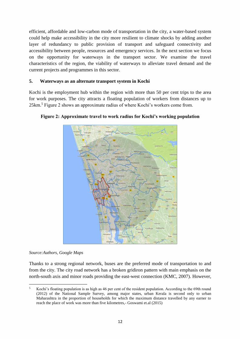
5. Waterways as an alternate transport system in Kochi
Kochi is the employment hub within the region with more than 50 per cent trips to the area
for work purposes. The city attracts a floating population of workers from distances up to
25km.5 Figure 2 shows an approximate radius of where Kochi’s workers come from.
Figure 2: Approximate travel to work radius for Kochi’s working population
Source:Authors, Google Maps
Thanks to a strong regional network, buses are the preferred mode of transportation to and
from the city. The city road network has a broken gridiron pattern with main emphasis on the
north-south axis and minor roads providing the east-west connection (KMC, 2007). However,
5 Kochi’s floating population is as high as 46 per cent of the resident population. According to the 69th round
(2012) of the National Sample Survey, among major states, urban Kerala is second only to urban
Maharashtra in the proportion of households for which the maximum distance travelled by any earner to
reach the place of work was more than five kilometres,- Goswami et.al (2015)

13
the limited road capacity of most regional and city roads means that congestion and travel
delays are common, leading to average travel times of over an hour. Most city roads have a
right of way less than 5 m. In terms of carriage width, most city roads are either single lane
(56.6 %) or less than single lane (16.3%) (NATPAC, 2006) (CPPR, 2016). A declining share
of public transport in the recent past and rapid growth in private ownership of vehicles has
heavily clogged the city. Kochi had registered a CAGR of 12.2 per cent in the number of
registered vehicles between 2002 and 2012, which is the second highest growth rate among
all the million plus cities in India (Transport Research Wing, 2013). Ernakulam district, to
which Kochi belongs, has the highest number of motor vehicles with valid registrations in the
state and adds the maximum number of vehicles every year (MVD, 2014).
Figure 3: Mode choice in commuting for work
Source: Adopted from Goswami et.al (2015)
In this context, Kochi’s waterways present an alternative to release some of the pressure from
the city’s congested roadways. Kochi’s western waterways form part of the 205-km West
Coast Canal or National Waterway 3 that runs from Kollam to Kottapuram and is used for the
movement of both passengers and goods. The waterways offer connectivity to not only
different parts of the city but also to bedroom communities outside the metro. At present, the
Kerala State Water Transport Department (KSWTD) is the key agency running passenger
ferries, along with some private operators, mainly in the western part of the city, connecting
the coastal areas and islands to the mainland. Figure 4 shows the key employment hubs in the
city and the main road networks and ferry hubs providing connectivity.
59%
15%
10%
9%
3% 3%
1% Bus
Two-Wheelers
Office Cab
Train
Car
Boat
Auto-Rickshaws / Cycle

14
Figure 4: Kochi’s key employment hubs and road and ferry connectivity
Source:Authors, based on information from Development Plan For Kochi City Region
Although historically well endowed with canals and waterways, the popularity of waterways
for transport has declined over time in the region. Kochi, which had more than 60 jetties in
the backwaters (CDIA, 2010), used to have an extensive ferry system, transporting
passengers and goods to urban areas and nearby districts. As the city developed, there was a
marked improvement in road-based transport in the city. The construction of bridges
connecting islands to the mainland was the most important factor in the modal shift from
ferries to road-based transport( Joseph,2012). It resulted in a substantial rise in private
ownership of vehicles in these islands as well as use of bus transport systems. The pre-
feasibility study for ferry services in Kochi (CDIA, 2010) reported that in 2008, over 2,200
daily bus departures were recorded from key island locations to the mainland, a number that
must have increased since. As illustrated in Figure 3, only 3 per cent of the commuter traffic
now uses ferries for travel. This is despite the fact that, if efficiently operated, ferry travel
would take substantially less time than road travel, especially with the congestion the bridges

15
now face. However, there were several reasons for the shift, the most important being the
poor state of the ferry infrastructure, inadequate frequency and unreliable services (Joseph,
2012).
Figure 5: Connectivity in Kochi City
Improved connectivity between the city centre and the densely populated areas of Fort
Kochi/Mattancherry and Goshree islands on the west through new bridges and roadways (highlighted
in white circles) has redirected passenger traffic from ferries to roads that allow for door-to-door
connectivity.
Source:Authors, based on information from Census 2011 & Development Plan For Kochi City Region
A recent development in the city’s transportation system however, is expected to have a
positive impact on this declining mode. Kochi has a new metro system, introduced in 2017,
which augments the city’s public transport supply (Figure 6). The system, developed by the
Kochi Metro Rail Ltd., has a north-south emphasis along a 25.61 km corridor from Aluva to
Petta near Tripunithura with 22 stations en-route. It is projected that the system will enable up
to 30 percent modal switch from road-based transport to the metro in the mainland (KMRL,
2013). Although the metro project does not currently extend to the islands and western part of
city, these areas, which are densely populated and comprise a major share of intra-city travel,
can benefit from an efficient waterways system working in complete tandem with the metro
network. KMRL, the agency in charge of the metro project, has acknowledged this potential
and proposed a “water metro” project that aims to overhaul the existing waterways system in
the city and provide cross-modal connectivity with the metro. The project envisages 16

16
identified routes, connecting 38 docks across ten islands and spans a total route network of 76
km to be implemented in two phases and aims to be fully operational in four years. Figure 6
shows the proposed network along Phase 1 and 2. It not only builds on the existing routes but
also proposes some extensions to the current network in the north and east. To facilitate
coordinated planning and implementation of these transport projects, and integrated
management of all transport systems, KMRL is also pushing for the creation of a Unified
Metro Transport Authority (UMTA) for Kochi, an umbrella transport agency envisaged under
the 2006 National Urban Transport Policy.
Figure 6: Phase 1 of Kochi metro project operating since 2017 & Phase 1 & 2 of
proposed Kochi water metro project.
Source: Wikipedia Commons6 & The New Indian Express7
A modal shift away from road transport would relieve the city of the extreme traffic
congestion that it is experiencing now. It also builds on Kochi’s potential to becoming the
principal node of hinterland connectivity through inland waterways in Kerala. NATPAC
(2014) has reported that development of Cochin Port-hinterland connectivity through inland
waterways could bring in an annual economic benefit of Rs.442 crore, in addition to several
other tangible and intangible benefits. Water based transport also holds great potential for the
tourism industry in the city. Kochi, which is already a favoured tourist destination, could gain
immensely from an efficient inland waterways system. This is also crucial for regional
development as the Kochi-Alappuzha backwater belt is amongst the most popular
destinations in the tourism map of Kerala. It is also opportune since the city is currently
6 Kochi Metro Route Map [Image]. (2013). Retrieved from https://commons.wikimedia.org/wiki/File:Kochi-metro-route-map.png 7 Water Metro Route Network Map [Image]. (2016). Retrieved from http://www.newindianexpress.com/cities/kochi/2016/aug/17/Water-Metro-Charting-routes-1510086.html

17
witnessing a socio-cultural revival with initiatives like Kochi-Muziris biennale. Efforts are
also underway on a large scale to conserve heritage properties and monuments in the city.
The restoration and revival of Kochi’s water bodies is elemental to these efforts.
The renewed focus on enhancing water transport systems, as part of an integrated public
transport network with the metro and bus systems, thus holds promise and helps Kochi build
its social, economic and climate resilience to safeguard itself from extreme events that
threaten to interrupt the city and its economy.
6. Limitations and Challenges to development of water ways in Kochi
6.1 Institutional Limitations
Due to its regional nature, a range of agencies have jurisdiction over various aspects of the
water transport system – setting up terminals, dredging, licensing, operating passenger
services, etc. These overlapping jurisdictions have led to institutional complexities and the
inability, so far, to deliver a unified, co-ordinated system.8 An Urban Metropolitan Transport
Authority (UMTA) integrating the metro, bus and boat transport modes has been proposed by
KMRL, but the bill for setting it up is still under the consideration of the state government. In
its absence, Kochi Metro Rail Limited (KMRL) is acting as the co-ordinator to streamline
works for the new metro and the proposed supporting water transport systems.
6.2 Network Limitations
One of the limitations of the ferry service is lack of permeability within the urban fabric of
the city through internal canals. Water transport systems in cities like Amsterdam and Venice
have been successful due to a large network and connectivity to different parts of the city.
Even then, water systems find it hard to compete with the convenience provided by the door-
to-door connectivity of roadways. In Kochi’s case, the western edge provides a good front for
water transport but there is limited scope for extending these services to the inland canal
system. This is because the naturally occurring inland channels in the east, in areas such as
Ernakulam and Kakkanad, are narrower and do not have the required navigable depth or
formal edges. Unchecked encroachment through illegal construction activity and dumping of
solid waste has further reduced the capacity of these systems to support transportation.
Considerable investment will be needed to formalise these inland waterways and make them
navigable.
As a result, much of the current passenger and goods water transport network in Kochi as
well as the proposed enhancements by Kochi Metro is concentrated in the west coast canal,
connecting the mainland on the east with Goshree, Fort Kochi and Mattancherry areas on the
west. Since Fort Kochi and Mattancherry are the most densely populated areas of the city,
8 Multiple agencies with a stake in Kochi waterways include the Inland Waterways Authority of India,
Greater Cochin Development Authority, Goshree Islands Development Authority, Kerala State Water
Transport Department, Kerala Shipping and Inland Navigation Corporation, Cochin Port Trust, Department
of Irrigation, Government of Kerala and Corporation of Cochin. For a detailed commentary on functions of
various stakeholders, refer to Joseph (2012)

18
providing alternate connectivity to these from the mainland is a priority from both a demand
management and resilience perspective. Being part of National Waterway 3, this channel also
has national support for regular maintenance of navigability. A parallel can be drawn here
with Seattle, where the city runs a successful ferry service between the mainland and the
islands off Puget Sound, saving commuters from the congestion on connecting bridges.
However, barring the case of waterfront activities that generate or attract traffic and can be
served exclusively by ferries, the role of the ferries is limited to being a link in the trip, its
success dependent on the efficiency of the connector or feeder systems that start or end
journeys.
6.3 Ecological Limitations
While there is need to restore and improve the natural waterways in the region to augment
connectivity and build resilience, their suitability for transportation needs to be viewed with
caution, taking into account the socio-ecological impact of action. By virtue of their location,
high productivity and services provided, estuarine ecosystems worldwide are often subjected
to severe ecological pressures (Kumar et.al, 2013). The Cochin backwaters too are an
important resource that offer flood protection and support the local economy. Small scale
fishing, farming (pokkali paddy and prawn alternating cultivation), cottage industry using
brackish water for coir processing and local ferry services have been the traditional activities
in the backwaters, enjoying a symbiotic relationship with the water system. In contrast,
modern uses such as large industries, ports, large-scale mechanised fishing and tourism and
increasing urban pressures (reclamation for development, transport, dredging, sewage and
waste disposal), have led to pollution of the backwaters and encroachment and deforestation
in the hinterland. Large scale reclamation and dredging to make these systems navigable have
already caused significant destruction of the mangroves that played a vital role in flood
protection and in sustaining the ecological balance of the area in and around the backwaters
(Thomson, 2002).
The sensitivity of the ecosystem thus needs to be taken into account while considering the use
of these waterways for transport, especially those more inland in the east. Uses that
complement their ecological value, such as non-motorised transport for local communities or
tourism purposes, may be a better fit for the eastern inland waterways, building on the
economic value of the resource in a sustainable manner. Even in cities like Amsterdam,
Bangkok, New Orleans, Birmingham and others with natural or man-made canals, the canals
are rarely used for daily commuter transport these days, but are more for recreational, leisure
and tourism activities. Even so, with regular upkeep, these systems do retain the potential to
be used as such in extreme events such as flooding, thus contributing to the city’s resilience.
7. Conclusion
The resilience of any city is a function of both its ecological and economic system. It should
be understood as the ability of the locale to counter both climate and economic shocks and its
capacity to constantly renew itself to withstand an ever changing set of risks. Processes to
enhance resilience should factor in both the aspects. The city of Kochi has much to gain from

19
the development of waterways. A sustainable water transport system will invariably mean the
revival of natural water channels in the city and the creation of climate- proof infrastructure;
the twin benefits would be an efficient transport system and increased resilience. The
degradation of the water system in the city has not only raised its vulnerability but has also
compromised its resilience capacity. In the case of Kochi, even when the importance of its
water bodies is appreciated at the policy level, the approach towards their regeneration or
maintenance has been ad hoc. While the present water metro project envisaged is
praiseworthy, the emphasis seems to be more on the economic aspect, especially the ease of
transport in the city. Global practices indicate that it is, in fact, possible to reap the economic
benefits of improved waterways without compromising on the environmental agenda. In a
city like Kochi, it has to be noted that both aspects are highly intertwined and support each
other. Environment sustainability need not exclude the multiple economic benefits that
development brings. Any approach discounting the importance of one or the other will limit
the true potential of the city. The limitations the city faces also calls for an integrated
approach with the involvement of all stakeholders. Above all, development of an efficient
water transport infrastructure is a unique chance for Kochi to right the wrongs of the past and
prepare itself better for the future.

20
References
Cities Development Initiative for Asia (CDIA). (2010). Pre-Feasibility Study: Urban
Transport, Cochin, India – Final Report Investment Proposal – Ferry Services.
Goswami, B., Kumar, N.A. and George, K.K., (2015). Patterns of Commuting for Work: A
Case Study of Kochi City. Research Unit on Local Self Governments, Centre for
Development Studies. Available at http://cds.edu/wp-
content/uploads/2015/12/RULSG-5.pdf, Accessed on December 27, 2017
Government of India (GOI). (2011). Census of India 2011. Office of the Registrar General
& Census Commissioner, Ministry of Home Affairs, Government of India. New
Delhi.
Government of Kerala (GoK). (2010 a) Development Plan for Kochi City Region 2031
Vol. I – Study and Analysis by the Department of Town and Country Planning
Government of Kerala (GoK). (2010 b) Development Plan for Kochi City Region 2031
Vol. III, Development proposals and development control regulations, prepared by
Department of Town and Country Planning, Government of Kerala
IPCC. (2014): Climate Change 2014: Synthesis Report. Contribution of Working Groups I,
II and III to the Fifth Assessment Report of the Intergovernmental Panel on Climate
Change [Core Writing Team, R.K. Pachauri and L.A. Meyer (eds.)]. IPCC, Geneva,
Switzerland, 151 pp.
Joseph. Y. (2012) A Study on Inland Water Transportation in Kochi City Region, Working
paper series, 2012, Centre for Public Policy Research. Available at
http://www.cppr.in/wp-content/uploads/2013/02/Report-on-Inland-Water-Navigation-
Final.pdf, Accessed on December 26, 2017
Kerala State Planning Board. (2014) Economic Review 2014. Government of Kerala.
Kochi Metro Rail Ltd (KMRL). (2013). Ridership Updation on Kochi Metro and Impact on
Pollutants, Final Report. Prepared by CDM Smith.
Kochi Metro Rail Ltd (KMRL). (n.d). The Transport & Mobility Scenario in Kochi: Past &
current Trends, Challenges. Available at http://www.codatu.org/wp-
content/uploads/Transportmobility-scenario-in-Kochi-by-KMRL1.pdf, accessed on
August 15, 2015
Kochi Municipal Corporation (2006). City Development Plan of Kochi.
Kumar M.K.S (2017). Long-term plans required for cleaning canals, drains in Kochi. The
Times of India, Jan 20, 2017. Available at
https://timesofindia.indiatimes.com/city/kochi/long-term-plans-required-for-cleaning-
canals-drains-in-kochi/articleshow/56673695.cms, Accessed on December 27,2017
21
Kumar, P.K.D., Gopinath, G., Murali, R.M. and Muraleedharan, K.R. (2013).
Geospatial analysis of long-term morphological changes in Cochin estuary, SW coast
of India. Journal of Coastal Research, 30(6), pp.1315-1320.
Kumar, S. P., Roshin, R. P., Narvekar, J., Kumar, P. D., & Vivekanandan, E. (2009).
Response of the Arabian Sea to Global Warming and Associated Regional Climate
Shift. Marine Environmental Research, 68(5), 217-222.
Kumar, P. K.D. (2006). Potential Vulnerability Implications of Sea Level Rise for the
Coastal Zones of Cochin, Southwest Coast of India. Environmental Monitoring and
Assessment, 123(1-3), 333-344.
Kumar, P. K.D (2001). Monthly mean sea level variations at Cochin, southwest coast of
India. International Journal of Ecology and Environmental Sciences, 27, 209-214.
Motor Vehicles Department (MVD). (2014). Number of Motor Vehicles Having Valid
Registration as on 31.03.2014. Government of Kerala. Thiruvananthapuram.
Murali, R. M., & Kumar, P. D. (2015). Implications of Sea Level Rise Scenarios on Land
Use/Land Cover Classes of the Coastal Zones of Cochin, India. Journal of
Environmental Management, 148 (January 2015), 124-133.
National Transportation Planning and Research Centre (NATPAC). (2014). Annual
Report 2013-14. Government of Kerala. Thiruvananthapuram.
ORNL, CUSAT. (2003). Possible Vulnerabilities of Cochin, India, to Climate Change
Impacts and Response Strategies to Increase Resilience. Oak Ridge National
Laboratory and Cochin University of Science and Technology
Shah Mihir (2016). Urban Water Systems in India: A Way Forward. Working Paper 323,
ICRIER working paper series, Indian Council for Research on International Economic
Relations
Shaji, C., Kar, S. K., & Vishal, T. (2014). Storm surge studies in the North Indian Ocean: a
review. Indian Journal of Geo-Marine Sciences. Vol 43(2), pp 125-147
Sriraman, S (2010). Long Term Perspectives on Inland Water Transport in India. RITES
Journal 12(1), 18.1 -18.14.
Thomson, K. T. (2002). Economic and Social Issues of Biodiversity Loss in Cochin
Backwaters. In Technical report (pp. 51-82). Cochin University of Science and
Technology Cochin, India.
Transport Research Wing (TRW), Ministry Of Road Transport & Highways (2013).
Road Transport Year Book (2011-12). Government Of India, New Delhi
22
Waterways Forward. (2012 a). Synthesis Report of Regional Action Plans and Virtual
Debates. Available at http://www.waterways-forward.eu/wp-
content/uploads/2012/11/Synthesis-Report-of-Regional-Action-Plans-and-Virtual-
Debates1.pdf ,accessed on February 16, 2017
Waterways Forward. (2012 b). Good Practice Posters & Leaflets. Available at
http://www.waterways-forward.eu/good-practice-posters-leaflets/ ,accessed on
February 16, 2017
Wong, P.P., I.J. Losada, J.-P. Gattuso, J. Hinkel, A. Khattabi, K.L. McInnes, Y. Saito,
and A. Sallenger, (2014). Coastal systems and Low-Lying Areas. In: Climate Change
2014: Impacts, Adaptation, and Vulnerability. Part A: Global and Sectoral Aspects.
Contribution of Working Group II to the Fifth Assessment Report of the
Intergovernmental Panel on Climate Change

23
LATEST ICRIER’S WORKING PAPERS
NO. TITLE AUTHOR YEAR
358 TOWARDS SUSTAINABLE,
PRODUCTIVE AND
PROFITABLE AGRICULTURE:
CASE OF RICE AND
SUGARCANE
ASHOK GULATI
GAYATHRI MOHAN
APRIL 2018
357 SUPPORTING INDIAN
FARMERS: PRICE SUPPORT OR
DIRECT INCOME/INVESTMENT
SUPPORT?
ASHOK GULATI
TIRTHA CHATTERJEE
SIRAJ HUSSAIN
APRIL 2018
356 SOLID WASTE MANAGEMENT
IN INDIA AN ASSESSMENT OF
RESOURCE RECOVERY AND
ENVIRONMENTAL IMPACT
ISHER JUDGE
AHLUWALIA
UTKARSH PATEL
APRIL 2018
355 CHANGING TASK CONTENTS
OF JOBS IN INDIA:
IMPLICATIONS AND WAY
FORWARD
PANKAJ VASHISHT
JAY DEV DUBEY
MARCH
2018
354 TRADE RULES IN E-
COMMERCE: WTO AND INDIA
ARPITA MUKHERJEE
AVANTIKA KAPOOR
MARCH
2018
353 SCALING UP ROOFTOP SOLAR
POWER IN INDIA: THE
POTENTIAL OF MUNICIPAL
SOLAR BONDS
SAURABH TRIVEDI
INDRO RAY
GREGOR VULTURIUS
AMRITA GOLDAR
LABANYA PRAKASH J
SANDEEP PAUL
AARSI SAGAR
MARCH
2018
352 CROP INSURANCE IN INDIA:
KEY ISSUES AND WAY
FORWARD
ASHOK GULATI
PRERNA TERWAY
SIRAJ HUSSAIN
FEBRUARY
2018
351 DEMONETISATION – A
GOLDEN OPPORTUNITY FOR
WIDENING THE TAXPAYER
BASE
RAJIVA RANJAN SINGH
ANANDITA BAGCHI
JANUARY
2018
350 TRADE FACILITATION
MEASURES TO ENHANCE
WOMEN’S PARTICIPATION IN
CROSS-BORDER TRADE IN
BBIN
NISHA TANEJA
SANJANA JOSHI
SHRAVANI PRAKASH
SAMRIDHI BIMAL
JANUARY
2018
349 AGRICULTURAL COMMODITY
FUTURES: SEARCHING FOR
POTENTIAL WINNERS
ASHOK GULATI
TIRTHA CHATTERJEE
SIRAJ HUSSAIN
DECEMBER
2017
348 WAITING FOR JOBS RADHICKA KAPOOR NOVEMBER
2017
1
About ICRIER
Established in August 1981, ICRIER is an autonomous, policy-oriented, not-for-profit,
economic policy think tank. ICRIER’s main focus is to enhance the knowledge content of
policy making by undertaking analytical research that is targeted at informing India’s policy
makers and also at improving the interface with the global economy.
ICRIER’s office is located in the institutional complex of India Habitat Centre, New Delhi.
ICRIER’s Board of Governors include leading academicians, policymakers, and
representatives from the private sector. Dr. Isher Ahluwalia is ICRIER’s chairperson.
Dr. Rajat Kathuria is Director and Chief Executive.
ICRIER conducts thematic research in the following eight thrust areas:
Macroeconomic Management Financial Liberalisation and Regulation
Global Competitiveness of the Indian Economy–Agriculture, Manufacturing and Services
Multilateral Trade Negotiations and FTAs
Challenges and Opportunities of Urbanization
Climate Change and Sustainable Development
Physical and Social Infrastructure including Telecom, Transport Energy and Health
Asian Economic Integration with focus on South Asia
Skill Development, Entrepreneurship and Jobs
To effectively disseminate research findings, ICRIER organises workshops, seminars and
conferences to bring together academicians, policymakers, representatives from industry and
media to create a more informed understanding on issues of major policy interest. ICRIER
routinely invites distinguished scholars and policymakers from around the world to deliver
public lectures and give seminars on economic themes of interest to contemporary India.