Embed Size (px)
Citation preview
Ventura Water Local Groundwater Assistance Grant ATTACHMENT 5. WORK PLAN
Attachment 5 – Work Plan 5-1
Work Items and Tasks
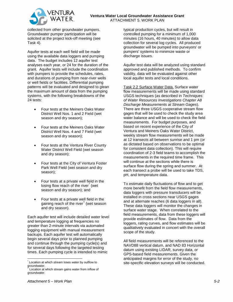
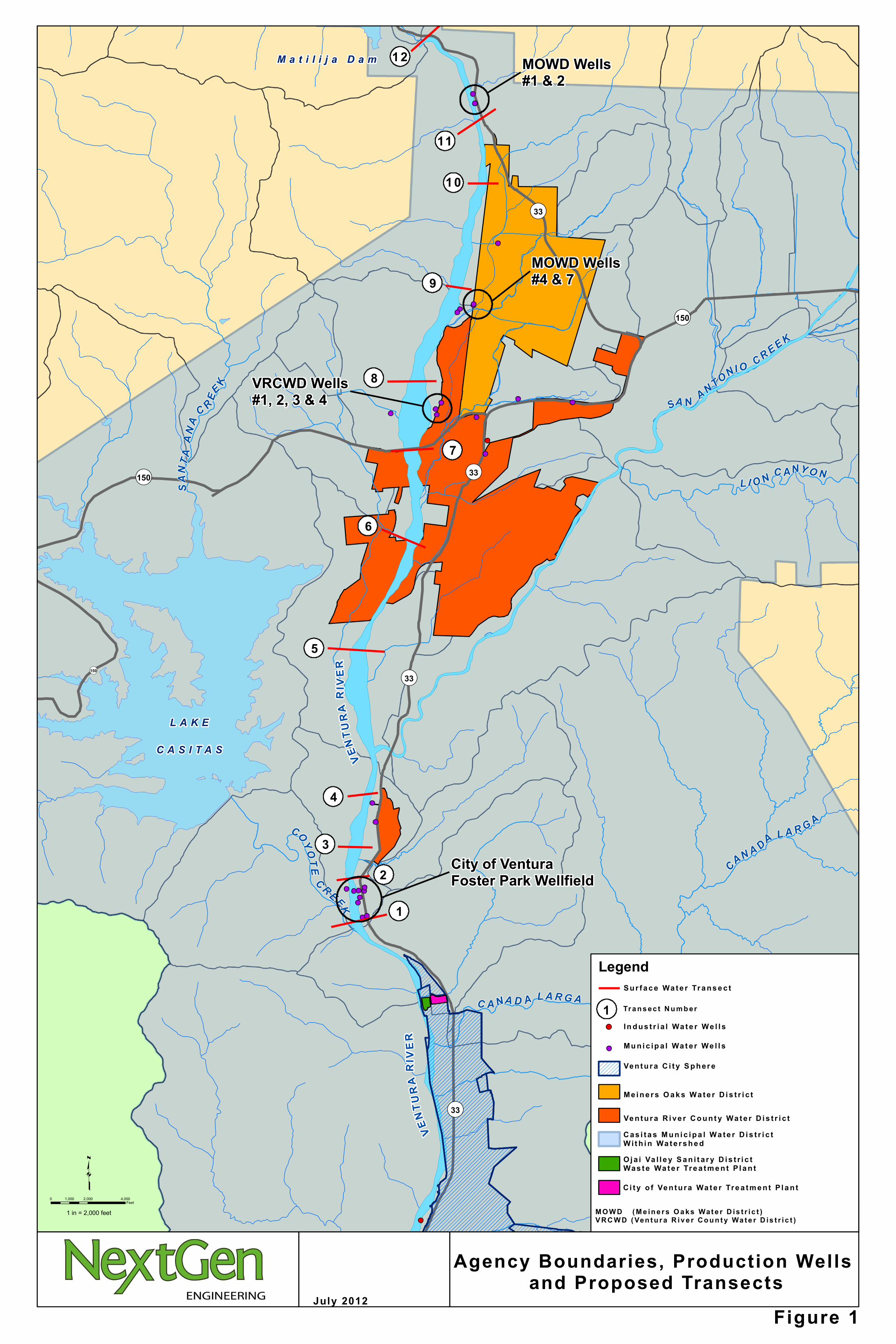
The following specific tasks are proposed to build upon existing data and understanding and work towards better groundwater management of the Upper Basin. Figure 1 shows the area of study, the locations of municipal wells, and transects that define critical reaches to be studied.
The City of Ventura, in coordination with parties to the MOA, will manage the grant, manage the stakeholder activities, and hire consultants as necessary to complete tasks described below.
Task 1: Finalize Data Collection Strategy (Consultant) This task is to build upon current local knowledge to create a monitoring and data collection program that will become a part of the groundwater model and future GWMP. The field data needs to be reliable, using professional practices, so that all stakeholders have confidence that it represents the conditions in the river and groundwater basins.
1. Review existing groundwater/surface water monitoring programs including those of the City of Ventura, Meiners Oaks Water District, Ventura River County Water District, and County of Ventura.
2. Finalize selection of monitoring wells that are representative of the groundwater in the alluvial aquifer, have a variation of distance from the production wells, and have or can be equipped with monitoring equipment. The wells will be selected for water levels and aquifer testing.
3. Finalize location of transects for flow measurements taking into consideration well locations, critical impediments, and accessibility. Figure 1 illustrates the 12 “candidate” transect locations. The Ventura River is a highly braided and variable stream so transect locations will need to be identified each spring once flood flows decrease.
4. Establish specific timing of data collection along river so that groundwater levels and surface flow monitoring results can be related. Surface flow will be measured using a combination of data loggers and in-
stream field measurements. During the day there is a diurnal change in flow. The sampling will be conducted in the morning and until 1 pm, after which surface flows naturally decrease because of evapotranspiration of the riparian habitat. A weekly surface water flow measurement for an average of 10 weeks each season for 2 seasons has been budgeted (see Attachment 6).
5. Set specific guidelines or flow thresholds for when to start and stop data collection. Thresholds are intended to ensure data is collected when well production could influence surface water flows.
6. Establish Quality Assurance Project Plan (QAPP), and Standard Operating Procedures (SOPs) so all stakeholders have confidence the data represents the conditions of the river and groundwater basin. Equipment meeting the standards of the QAPP and SOPs will be identified.
Deliverables for Task 1: A Technical Memorandum will be prepared that includes monitoring location map(s) and which details the final monitoring strategy including the types of monitoring, a QAPP, and SOPs. The Technical Memorandum will be completed within 30 days of the City of Ventura selecting a consultant. Task 2: Field Data Collection (Consultant) The field data collection will begin as soon as possible to capture the flows or absence of flows during the two-year grant performance period.
Task 2.1 Groundwater Data. The consultant will collect groundwater level data at wells along the mainstem of the river, representing the groundwater in the alluvial materials, and will be taken by weekly soundings or by pressured transducer data loggers that record data a minimum of every 60 minutes all year. The budget includes installation of 20 data loggers and weekly soundings at an additional 10 wells.
Quarterly, the consultant will collect available well production data from municipal agencies, mutual water companies, and agricultural users. As part of the MOA, several municipal groundwater producers have already agreed to participate in the project. To the extent possible groundwater production data will also be
Ventura Water Local Groundwater Assistance Grant ATTACHMENT 5. WORK PLAN
Attachment 5 – Work Plan 5-2
collected from other groundwater pumpers. Groundwater pumper participation will be solicited at the project kick-off meeting (see Task 4).
Aquifer tests at each well field will be made using the available data loggers and pumping data. The budget includes 12 aquifer test analyses each year, or 24 for the duration of the grant. Aquifer tests will include the coordination with pumpers to provide the schedules, rates, and durations of pumping from near-river wells or well fields or facilities. Differential pumping patterns will be evaluated and designed to glean the maximum amount of data from the pumping systems, with the following breakdowns of the 24 tests:
• Four tests at the Meiners Oaks Water District Well Nos. 1 and 2 Field (wet season and dry season);
• Four tests at the Meiners Oaks Water District Well Nos. 4 and 7 Field (wet season and dry season);
• Four tests at the Ventura River County Water District Well Field (wet season and dry season);
• Four tests at the City of Ventura Foster Park Well Field (wet season and dry season);
• Four tests at a private well field in the losing flow reach of the river* (wet season and dry season); and
• Four tests at a private well field in the gaining reach of the river† (wet season and dry season).
Each aquifer test will include detailed water level and temperature logging at frequencies no greater than 2-minute intervals via automated logging equipment with manual measurement backups. Each aquifer test will automatically begin several days prior to planned pumping and continue through the pumping cycle(s) and for several days following the targeted testing times. Each pumping cycle is intended to mimic * Location at which stream loses water by outflow to groundwater. † Location at which stream gains water from inflow of groundwater.
typical production cycles, but will result in controlled pumping for a minimum of 1,000 minutes (16 hours, 40 minutes) to allow data collection for several log cycles. All produced groundwater will be pumped into purveyors' or pumpers' systems to minimize waste or discharge issues.
Aquifer test data will be analyzed using standard approved and published methods. To confirm validity, data will be evaluated against other local aquifer tests and local conditions.
Task 2.2 Surface Water Data. Surface water flow measurements will be made using standard USGS techniques (as described in Techniques of Water Resources Investigations Chapter A8 Discharge Measurements at Stream Gages). There are three USGS cooperative stream flow gages that will be used to check the study area water balance and will be used to check the field measurements. For budget purposes, and based on recent experience of the City of Ventura and Meiners Oaks Water District, weekly stream flow measurements will be made at 12 transects all between sunrise and 1 pm (or as dictated based on observations to be optimal for consistent data collection). This will require coordination of 2-3 field teams to accomplish the measurements in the required time frame. This will continue at the sections while there is surface flow during the spring and summer. At each transect a probe will be used to take TDS, pH, and temperature data.
To estimate daily fluctuations of flow and to get more benefit from the field flow measurements, data loggers with pressure transducers will be installed in cross sections near USGS gages and at alternate reaches (6 data loggers in all). These data loggers will monitor the changes in surface water stage. When correlated to the field measurements, data from these loggers will provide estimates of flow. Data from the loggers, rating curves, and flow estimates will be qualitatively evaluated in concert with the overall scope of the study.
All field measurements will be referenced to the NAVD88 vertical datum, and NAD 83 Horizontal datum using existing LIDAR, survey data, or GPS-based field measurements. Given the anticipated margins for error of the study, no site-specific elevation surveys will be conducted.
Ventura Water Local Groundwater Assistance Grant ATTACHMENT 5. WORK PLAN
Attachment 5 – Work Plan 5-3
Deliverables for Task 2: Weekly summaries of the collected groundwater data and surface water data will be prepared during the surface water monitoring period. These summaries will compare surface water field data against USGS gage data. Field data from aquifer tests will include raw water level, production rate, and temperature data from aquifer tests, maps of tested wells, and maps of surface water features. The weekly summaries will include a brief water balance summary. Electronic data compilations will be prepared in common groundwater model formats such as Microsoft Excel.
Task 3: Report, Correlations and Water Balance Analysis (Consultant) After each week of surface flow measurements, a lumped parameter water balance will be developed – at a minimum showing surface inflow and outflow and, if available, pumping volume for each reach. A correlation between pumping and surface water will be made and standard statistics, including the R square value, calculated to evaluate correlation strength.
At the end of each year, a lumped parameter water balance and pumping correlations with longer time steps will be developed for the study area.
The reach-by-reach water balances may reveal areas where additional data is needed. Other tests, flow studies or estimates of parameters of the water balance may be recommended to answer specific questions. Recommendations for the groundwater model will be made.
Reporting will include narrative descriptions of aquifer testing, raw data from aquifer tests, maps of tested wells and surface water features, and will describe the analytical methods applied to the data (analytical methods will be based on standard professional practice using the software package AQTESOLV). The reporting will include graphs/charts of key components such as production rates and durations, water levels, drawdown, and temperature.
Deliverables for Task 3: A draft report will be prepared that includes the deliverables for Task 1, the results of the field data collection of Task 2, and the analytical results of the aquifer tests, correlations and water balances. A set of recommendations will also be included. The draft report will be sent to the stakeholders for
review and a meeting held to present the draft report. Comments will be collected from the stakeholders and a final report prepared. The final report and data files will be submitted to the State, and an electronic copy provided to the parties of the MOA.
Task 4: Stakeholder Involvement (City of Ventura) The City, in coordination with the other parties to the MOA, has already developed a list of entities who pump groundwater along the Ventura River mainstem. The City will continue to utilize this list as well as announcements at the Ventura River Watershed Council to solicit input to, and participation in, the Interaction Study. The parties to the MOA will organize venues, provide publicity (fliers, email bulletins), invitations and agendas. The consultant will prepare summaries of the project goals, schedules, and when available, results for each meeting. Four specific outreach meetings are proposed as part of the project:
• 1st year grant kick off meeting – within a month of grant award.
• 1st year progress meeting to go over initial results and any problems encountered. To be held after at least 8 weeks of field measurements.
• 2nd year field work season kick-off meeting
• Review of Draft report.
In addition, stakeholders will be invited to participate by:
• Providing data – pumping data, water levels, etc.
• Providing river or well access for field measurements or aquifer testing
• Invitations to Watershed Council or Watershed activities
• Regular updates via the Ventura River Watershed Council website, http://www.venturawatershed.org/ and updates at monthly meetings
River access is available to each transect location. Several of the proposed sites are adjacent to or on properties belonging to parties to the MOA. If agricultural and private well owners agree to participate, a letter of
Ventura Water Local Groundwater Assistance Grant ATTACHMENT 5. WORK PLAN
Attachment 5 – Work Plan 5-4
agreement to access the well or to test it will be provided to the landowners. The letter will discuss aquifer testing using a data logger or other method for water levels. An identification badge will be provided to project field staff for easy identification by the stakeholders.
Deliverables for Task 4: This task will be part of each key milestone of the grant, from the beginning kick-off meeting to the summary of results. Deliverables will include stakeholder meetings and meeting materials, any data provided by stakeholders, letters of agreement for access and stakeholder comments on the Interactions Study Report.
Task 5: Grant Management (City of Ventura) The City of Ventura will be the grant recipient and grant manager. City staff are committed to work with DWR staff and will submit the quarterly reports and other deliverables to the State.
Tasks Not Necessary Based on the nature of the work, scientific data collection, all project related activities qualify for an exemption under the California Environmental Quality Act. See CEQA Guidelines Section 15306.
Strategy for Evaluating Progress and Performance
The City of Ventura performed stream measurements in the spring of 2010, 2011, and 2012. Meiners Oaks Water District performed stream measurements during the winter and spring period of 2012. This past work has given the City and Ventura River stakeholders a knowledge of the level of effort required to properly conduct this work.
To be successful the Interaction Study must involve relevant stakeholders . The proponents of this grant are already working with stakeholders as evidenced by the MOA and the letter to stakeholders requesting participation (included with Attachment 3). Early commitment by stakeholders is critical component for success.
Technical checking during the data collection will also provide immediate data review and opportunity to refine specific data collection problems. Field stream flow measurements near a USGS stream gage will be checked with
the provisional data as measured independently by the USGS. After each week a simple water balance for each reach will be made to get a feel for impacts of groundwater pumping and other factors on surface flow.
The quarterly reports to DWR will be used to identify how well the project is performing and if any mid-course corrections are needed.
Summary of Deliverables
• Weekly water balance summaries during surface water monitoring seasons
• Quarterly progress reports for DWR
• Technical memorandum summarizing data collection strategy
• Draft Report for stakeholder review
• Final report
• Final field data summarized and formatted for use on groundwater models
• Stakeholder communications
• Stakeholder meetings and meeting materials
C A NA D A L A R G A
SANT
A A N
A
C R EE
K
CAN A DA L A R G ACOYOTE
C R E EK
L I O N C ANY O N
SA N A N TONI O C R E E K
q
VENT
URA
RIVE
R
0 2,000 4,0001,000Feet
1 in = 2,000 feet
July 2012
Agency Boundaries, Production Wells and Proposed Transects
VENT
URA
RIVE
R
¬«150
¬«150
L A K E
C A S I T A S
M a t i l i j a D a m
¬«33¬«150
¬«33
¬«33
¬«33
Figure 1
MO W D ( M e in e r s O a ks Wat e r D is t r i c t )V R C W D ( Ven t u r a R iv e r C o u n t y Wa t e r D is t r i c t )
1
4
5
7
6
8
3
2
9
11
10
12
1 Tr a n s ec t N u m b er
VRCWD Wells#1, 2, 3 & 4
MOWD Wells#1 & 2
MOWD Wells#4 & 7
City of Ventura Foster Park Wellfield
Legend
Ven t u r a C i t y S p h er e
Me i n e r s O a k s Wa t e r D i s t r i c t
Ve n t u r a R i ve r C o u n t y Wa t e r D i s t r i c t
O j a i Va l l e y S a n i t a r y D i s t r i c t Was t e Wa t e r Tre a t m e n t P l a n t
C i t y o f Ve n t u ra Wa t e r Tre a t m e n t P l a n t
Su r f a c e Wa t e r Tr a n s e c t
C as i t a s M u n i c i p a l Wa t e r D i s t r i c t W i t h i n Wa t e r s h e d
In d u s t r i a l Wa t e r We l l s
Mu n i c ip a l Wa t er We l l s

![Flyer - 2010 Areo-Fire Demo Custom Pumper Tanker[2] Pumper Tan… · Microsoft Word - Flyer - 2010 Areo-Fire Demo Custom Pumper Tanker[2].doc Author: Marie-Josee Created Date: 12/15/2009](https://img.pdfslide.us/doc/110x75/5f29e30032e90c4ed24c8078/flyer-2010-areo-fire-demo-custom-pumper-tanker2-pumper-tan-microsoft-word.jpg)