Embed Size (px)
Citation preview

BIODIVERSITAS ISSN: 1412-033X
Volume 20, Number 11, November 2019 E-ISSN: 2085-4722
Pages: 3189-3198 DOI: 10.13057/biodiv/d201111
Woody plant communities in the Philippine teak forest landscape along
Verde Island Passage, Batangas, Luzon, Philippines
ANACLETO M. CARINGAL1,2, INOCENCIO E. BUOT JR.1,3,4,♥, ELAINE LOREEN C. VILLANUEVA3
1School of Environmental Science and Management, University of the Philippines Los Baňos. College Laguna 4031, Philippines email: [email protected]
2Program for Tropical Forestry, College of Agriculture and Forestry, Batangas State University-Lobo. Lobo Batangas 4229, Philippines 3Institute of Biological Sciences, College of Arts and Sciences, University of the Philippines Los Baňos. College Laguna 4031, Philippines
4Faculty of Management and Development Studies, University of the Philippines Open University. Los Baňos Laguna, Philippines
Manuscript received: 17 December 2018. Revision accepted: 14 October 2019.
Abstract. Caringal AM, Buot IE Jr, Villanueva ELC. 2019. Woody plant communities in the Philippine teak forest landscape along
Verde Island Passage, Batangas, Luzon, Philippines. Biodiversitas 20: 3189-3198. The study described the communities of woody
plants in a semi-evergreen tropical forest dominated by endemic Philippine teak (Tectona philippinensis Benth. & Hook. f, Lamiaceae)
and determined the local environmental factors affecting the distribution of dominant woody species across the Philippine teak forest
(PTF) landscape. The Philippine teak is a Critically Endangered species according to the International Union for the Conservation of
Nature (IUCN). Quantitative dominance analysis of arboreal vegetation data (basal area and relative dominance) from 24 (20m x 20m)
sampling plots generated the cluster dendrogram, while Canonical Correspondence Analysis (CCA) was performed for 47 woody
species and habitat-environment variables. As a result, four vegetation zones were named: (I) pure stand of Tectona philippinensis, (II)
mixed T. philippinensis-Garuga floribunda-Terminalia polyantha, (III) mixed Celtis latifolia-T. philippinensis and (IV) mixed
Tamarindus indica-Xylocarpus rumphii. These zones were governed more by physiographic (altitude ) and edaphic influences of
predominantly agro-coastal landscapes. The environmental variables were essential in verifying not only the association of dominant
tree flora in the local landscape but also provide insight for forest management zoning and the ecological requirements of the tree
species for in-situ and ex-situ biodiversity conservation.
Keywords: Endemic species, Philippine teak, Tectona philippinensis, Verde Island Passage
INTRODUCTION
The tropical forests of Southeast Asia is distinct in
terms of floristic composition and diversity due to complex
biogeography and environmental heterogeneity (Whitmore
1975, 1988; Newbery et al. 1992; Buot and Okitsu 1998;
Newbery et al. 1999; Belonias and Aguilar 2004; Buot and
Osumi 2011; Heng et al. 2017). Forest vegetation has a
subtle response to environmental influences, resulting in
variation in species composition and structure, and serve as
bio-indicators of landscape productivity and human
disturbances (Buot 2007; 2008; Sopsop and Buot 2013;
Nguyen et al. 2015; Van and Cochard 2017). Thus, it was
always of interest and value to investigate the plant
communities in this landscape (Whittaker 1960, 1965;
Mueller-Dombois and Ellenberg 1974; Aragones 1991;
Villanueva and Buot 2018).
In the Philippines, there is the existence of diverse
natural forests known as ecotypes or formation
characterized by distinct species composition and structure,
which were classified based on the dominant tree elements
(Department of Environment and Natural Resources-
United Nations Environment Programme, 1997; Baguinon
2000; Malayang 2001; Pulhin 2002). These formations
ranged from sea level up to 2,954 m altitudes and were the
focus of ecological classification since the 1900s (Whitford
1909, 1911; Whitmore 1984; Cadiz 1986; Fernando 1988;
Tan and Rojo 1988; Madulid 1994; Fernando et al. 2008).
The Philippine teak forest (PTF), however, has not yet been
widely studied among the unique ecotypes in the
Philippines.
In Batangas Province along the Verde Island Passage,
the forest with Philippine teak (Tectona philippinensis
Benth. & Hook. f, Lamiaceae) occurs as fragments across
the agro-coastal landscape at low altitudes (05-200 m asl.
particularly in the municipalities of Lobo, San Juan, and
Taysan and Batangas City where the natural tree
populations show spectacular flowering episodes preceding
a long summer (Agoo and Oyong 2008; Caringal et al.
2015). Tectona philippinensis was first described by British
botanists George Bentham and Joseph D. Hooker (1876)
based on the specimens deposited at London’s Kew
Herbarium which was collected by English naturalist Hugh
Cuming (1432) from the shores of Batangas, Luzon.
Because of its limited and fragmented distribution, the
species is of special interest to phytogeographers in the
Malesian Region (Madulid and Agoo 1990). Based on the
assessment criteria of the International Union for the
Conservation of Nature (IUCN), T. philippinensis has been
classified as Critically Endangered (Madulid et al. 2008).
Given the narrow distribution and current conservation
status of Tectona philippinensis, it is therefore important to
study the ecological aspect of the PTF to provide in-depth
and significant information about this unique ecotype in the

BIODIVERSITAS 20 (11): 3189-3198, November 2019
3190
Philippines. As there were fewer local landscape-level
studies about the Philippine teak, this study was undertaken
to reveal the dominant floristic elements according to plant
community patterns of the Philippine teak forest. Using the
data gathered from the vegetation surveys in the Philippine
teak forest, the researchers used classification analysis
(Cluster Analysis) in identifying the plant communities in
the study area. Moreover, ordination analysis (Canonical
Corresponding Analysis) was also utilized in investigating
the influence of the environment and anthropogenic factors
on the species distribution in the Philippine teak forests. The
results can be used in forest management zoning particularly
in locally and nationally important ridge-to-reef biodiversity
conservation corridors of Verde Island Passage.
MATERIALS AND METHODS
Study area
The vegetation survey was conducted along Batangas
Province, particularly in the areas of Batangas City,
municipality of Lobo, and Isla Verde (08-321 m asl,
13°30’-13°40’ North latitudes and 121°05’-121°15’East
longitudes) in southwestern Luzon, Philippines (Figure 1).
Twenty-four (24) 20m x 20m vegetation plots were taken
from Isla Verde to the mainland (56.48 km connectivity),
which have gentle to undulating, rolling to moderately
steep slopes (0.10 to 51.99%). The plots were located for
some distances (58.5m to 6225.28m) along the coastal cliff
towards inland ridges and narrow valley facing the sea of
Verde Island Passage (Figure 1). The landscape consists of
volcanic agglomerates from various ages such as Talahib
Andesite (Upper Oligocene-Miocene), Lobo agglomerate
(Pleiocene-Pleistocene) and San Juan Quartz Diorite
(Lower Miocene) where the underlying geography is
shallow, soft and porous reef limestone (Pleistocene)
including bushes of corals, shells, algae structure and
recently alluvium formation (Bureau of Soils 1987; Bureau
of Mines and Geo-Sciences-Mindoro Resources Limited
Gold Philippines Inc 1981; Caringal 2007; Comprehensive
Land Use Plan of Lobo, Batangas 2012; Cox 2010;
Mindoro Resources Limited 2004). The mean annual
precipitation (1980-2016) is 151.89 mm in Batangas
Province (Figure 2). The precipitation in the province
reaches is at its highest records in July (331mm). Low
rainfall (27-32mm) was experienced during summer,
January to April. Annual mean temperature (AMT) was
27.36°C ranging from 26°C-29°C (Figure 2).
Procedures
Forest vegetation survey
Fieldworks were conducted from October 2016-
February 2017 and resulted in a total of 24 (20m x 20m)
vegetation plots (=0.96ha). The sampling locations were
identified before successive field surveys of the Tectona
philippinensis forests. The plots were purposively selected
based on (i) the quality of trees and associated plants and
(ii) the presence of human-related disturbances or
expansion activities that may affect the forest structure. Six
vegetation plots were located in the coastal zone (including
1 island coast), three plots in a narrow inland valley, and 15
plots in inland ridges-all lying apart west to east from north
to south directions (Figure 1). Vegetation assessment was
done following the techniques of Mueller-Dombois and
Ellenberg (1974).
Figure 1. The Philippine teak forest landscape along the Verde Island Passage, Batangas Luzon, Philippines. The study plots were
shown as small 1-24 black squares from an island to coastal-mainland of Batangas Province, Philippines

CARINGAL et al. – Trees of Philippine teak forest
3191
Figure 2. The 36-Year (1980-2016) climogram showing the
monthly average precipitation and temperature for Batangas
Province, Philippines (Data retrieved from Synoptic Station
Records: Ambulong, Batangas. Philippine Atmospheric,
Geophysical and Astronomical Services Administration
(PAGASA), Diliman, Quezon City, Philippines)
In each plot, the diameter at breast height (DBH) of
trees (at least ≥10cm) was measured with a diameter tape
at 1.3 m from the ground while heights were estimated
visually following Erenso et al. (2014). Crown dimensions
were measured by a meter tape following Almazol and
Quintana (2009). Altitudes and coordinates of all study
plots were taken using a Garmin 76Csx Global Positioning
System (GPS) receiver.
Woody plants were identified with the help of local
botanists and verified with photographs of plants from the
field and herbarium vouchers lodged at the Batangas State
University Herbarium (BatStateU-H) and Plant Biology
Division Herbarium of the Institute of Biological Sciences,
University of the Philippines at Los Baňos (UPLB).
Species nomenclature followed the Revised Lexicon of
Philippine Trees (Rojo 1999), An Enumeration of
Philippine Flowering Plants (Merrill 1923-1926),
Flowering Plants and Ferns of Mt. Makiling (Fernando et
al. 2004) and Dictionary of Philippine Plant Names
(Madulid 2001).
Data analysis
Cluster analysis
To identify the plant communities in the forest
landscape, the basal area (BA) values of the woody species
were subjected to cluster analysis using the unweighted
pair group method with arithmetic mean (UPGMA)
algorithm and Euclidean distance as the index of similarity
among the plots. The PAleontological STatistical (PAST)
software (Hammer et al. 2010) was used to run the analysis
and generate the cluster dendrogram of the plots. The
diagram was used to visualize the representation of the
clusters of the vegetation plots as plant communities in the
landscape.
Dominance analysis
The dominant species were identified to further
describe each of the plant community that was identified
from the cluster analysis. In this study, the relative basal
area (RBA) of the woody species was used as a measure of
dominance. These were quantitatively identified using the
of Ohsawa (1984):
Where:
d : The deviation
xi : The actual percent share [in this case, the RBA] of
the top species (T), i.e, the top dominant in the one-
dominant model, or the two top dominants in the two-
dominant model and so on
x : The ideal percent share based on the
aforementioned model
xj : The percent share of the remaining species (U)
N : The total number of species.
Consequently, each plant community (cluster) was
named after the dominant and co-dominant tree flora, i.e.
species with the highest RBA values. The number of the
dominant species that represent the plant communities was
based on the formula above.
Proximity analysis for physiographic and anthropogenic
factors
Proximity analysis of the Philippine teak plots to the
various physiographic regime such as altitude (m asl.) and
distances (m) to or from the streams, coast or shoreline and
anthropogenic disturbances (e.g. roads, built-up areas,
settlements, farms) was undertaken by an ArcGIS
specialist. This computed the approximate straight line
distance (measured in meters) between a plot and any
spatial object, given a UTM 51N projected coordinate
system and a WGS 1984 geographic projection. The stream
network used for the analysis was topographically derived
from NAMRIA's 5m spatial resolution IfSAR DEM,
provided that first-order streams have a minimum
catchment area of 20,000m². The road network is from
Open Street Maps, and built-up areas were isolated from
the latest available land cover map of NAMRIA. The
results of the GIS-based approximate analysis, however,
was in some aspects validated with the actual observation
in the studied plots, hence there were some data fine-
tunings.
Edaphic environment analysis
These are the results of laboratory analysis done on
basic soil chemical properties such as acidity (pH),
moisture content (%MO), organic matter (% OM) and
organic carbon (% OC), nitrogen (% N), phosphorus (P
ppm), and potassium (K ppm). Soil samples in each plot
were collected uniformly following the procedures
formulated by PCARR (1980). Soil sampling point (25 cm
x 25 cm x 30 cm pit) was dug using an auger and spade

BIODIVERSITAS 20 (11): 3189-3198, November 2019
3192
from four corners of each plot and 1 from the middle. At
least 1kg soil slices from these 5 points were mixed
thoroughly and cleared with stones, grasses, weeds or other
plant debris. Each 1kg soil sample was sealed in a plastic
bag, labeled and were analyzed at the Regional Soils
Testing Laboratory of the Philippine’s Department of
Agriculture (DA) in Lipa City, Batangas. These
quantitative values were identified and used in analyzing
the influence of the environment variables (including soil
data) on the formation of the plant communities in the
landscape.
Canonical correspondence analysis
To explain the relationship of dominant tree flora in the
Philippine teak forest with the habitat environment factors,
Canonical Correspondence Analysis (CCA) of Ter Braak
(1986) was performed using the statistical software R
version 3.4.2 (R Core Team, 2013) with the vegan package
(Oksanen et al. 2007). Environmental factors including soil
data, altitude, slope and proximity to anthropogenic
disturbances were tested (Table 1). These environmental
gradients are the basis for visualizing (modelling) and
describing the differential habitat preferences (niches) of
taxa through an ordination diagram.
RESULTS AND DISCUSSION
Plant communities of the woody plants in the Philippine
teak forest landscape
The dendrogram generated from cluster analysis of
woody species basal area (BA) revealed four plant
communities (Table 2, Figure 3) named according to their
dominant species: (I) pure Tectona philippinensis (33-213
m asl.), (II) mixed Tectona-Garuga-Terminalia (37-321 m
asl.), (III) mixed Celtis-Tectona (53 m asl.) and (IV) mixed
Tamarindus-Xylocarpus (8-209 m asl.) (Figure 4).
Table 1. Environmental variables used in Canonical
Correspondence Analysis (CCA)
Environmental variable Abbreviation
Physiographic Percent slope SLP
Proximity to the sea SEA
Proximity to the river RIV
Altitude ALT
Edaphic Soil moisture MO
Organic carbon OC
Organic matter OM
pH pH
Phosphorus P
Potassium K
Anthropogenic Proximity to built-up areas/
settlement
SETL
Proximity to swidden or farm FR
Proximity to road RD
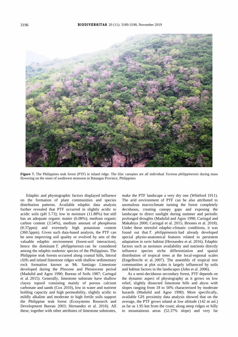
Cluster I. Pure Tectona forest (33-213m asl.): It was
formed from a broadleaved monsoon forest, turning
completely deciduous in summer months (January-April)
located in inland ridges (Figure 7), narrow valley and coast.
This plant community has 25 woody species with many
indigenous trees such as Memecylon edule, Terminalia
polyantha, Vitex parviflora, Sterculia foetida and Hibiscus
tiliaceous. There are many anthropogenic disturbances in
almost all the plots (Table 2). The tree height were ranged
from 4 to-22 m while DBH ranged from 10 to 77.66 cm.
The maximum basal area for the most dominant species,
i.e. T. philippinensis was 748.01 m2 and with RBA of
72.65%.
Cluster II. Mixed Tectona-Garuga-Terminalia forest
(37-321 m asl.): This cluster is a broadleaved semi-
deciduous forest from inland ridges to the coast composed
of other co-dominant species such as Vitex parviflora,
Gliricidia sepium, Dehassia triandra, Memecylon edule,
Wrightia pubescens and Scolopia luzonensis. The plots
were also affected by various anthropogenic disturbances
(Table 2). This plant community had 36 woody species
with DBH range from 4.14-60.48 cm and height of 6-23 m.
The combined total basal area for the three dominant
species was 1,103.98 m2 with T. philippinensis having the
highest RBA of 36.43%.
Cluster III. Mixed Celtis-Tectona (53 m asl.): This is a
semi-evergreen forest in a coastal cliff (Plot 5) with very
few (5) and scanty woody species adjoining uphill swidden
patches overlooking the coastal road and dense settlement
below. In this zone, Celtis latifolia is the evergreen
broadleaved tree associated with deciduous T.
philippinensis. Tree DBH ranged from 3.81-57.93 cm
while heights were 5-15 m. The combined basal area of the
dominants (C. latifolia and T. philippinensis) was 44.54 m2.
The RBA of C. latifolia was 51.51%, while T.
philippinensis was 35.54%.
Cluster IV. Mixed Tamarindus-Xylocarpus (8-209 m
asl.): This is an evergreen forest in ridge valley and beach
coast composed of 12 woody species having DBH that
ranged from 3.81-91.99 cm and heights ranged from 3-
20m. In this plant community, T. philippinensis was
overshadowed by most dominant species Tamarindus
indica with a basal area of 161.42 m2 and RBA of 52.79%
and, Xylocarpus rumphii with a basal area of 66.74m2 and
RBA of 21.83%. In this zone, Terminalia catappa,
Thespesia populnea, and Guettarda speciosa are co-
dominant trees.
Environmental factors influencing the distribution of
woody plants
Using Canonical Correspondence Analysis (CCA), the
distribution of 24 sampling plots (quadrats) and 47 woody
species over environmental gradients were presented in
Figure 5 and Figure 6. The eigenvalue of Axis 1 was 0.531
while Axis 2 was 0.408 with 24.67% total inertia (weighted
variance) and 42.12% of the variance in the weighted
averages and class totals of the species with respect to
environmental variables. The CCA biplot showed that
habitat environment variables affected the distribution and
dominance of species in the forest.

BIODIVERSITAS ISSN: 1412-033X
Volume 20, Number 11, November 2019 E-ISSN: 2085-4722
Pages: 3189-3198 DOI: 10.13057/biodiv/d201111
Table 2. Tree communities, distribution of the sample plots and observed human disturbances in the Philippine teak forest landscape
Tree communities
Tree or
woody
species
richness
Altitude
(m asl.)
Slope
(%)
Dominant
trees
∑BA
(m2)
RBA
(%)
Observed
Anthropogenic
Disturbances
(ADs)*
Location
Cluster I
(plots: 3, 4, 7, 16, 17,13,
20,1, 24, 22, 12)
25
33-213 0.61-86.17 Tectona
philippinensis
748.01 72.65 SCP, PGL, AT,
FLG, Ro, HS
Inland ridges,
valley, coast
Cluster II
(plots: 6, 14, 15, 8, 18,
9, 10, 21, 11, 19)
36
37-321 2.68-
251.99
T. philippinensis
Terminalia polyantha
Garuga floribunda
521.43
395.84
186.71
36.43
27.66
13.05
SCP, PGL, AT,
FLG, Ro, HS
Inland ridges,
coast
Cluster III
(plot: 5)
5 53 32.02 Celtis latifolia
T. philippinensis
26.36
18.18
51.51
35.54
SCP, PGL, AT,
FLG, Ro, HS
Coastal cliff
Cluster IV
(plots: 2, 23)
12
8-209 56.87-
97.88
Tamarindus indica
Xylocarpus rumphii
161.42
66.74
52.79
21.83
AT, FLG, Ro, HS Ridge valley
and ridge coast
*Notes: Observed Anthropogenic Disturbances (ADs): SCP: Near swidden and crop plantations, e.g. ates, ipil-ipil, mahogany, other
cropping (within 5-20 m distance); PGL: Near pasture or grazing land or the study plots with ipil-ipil source of forage (within 5-20m
distance); AT: Near access trail within 5-20m distance; FLG: The plots with remnant cuts of fuelwood or lumber gathering; Ro: Near
road within 5-100m distance; HS: Near human settlement within 10-100m distance
Figure 3. Dendrogram generated from cluster analysis based on woody species basal area (BA) in the Philippine teak forest landscape
using the UPGMA algorithm with cophenetic correlation of 0.88. At a Euclidean distance between 50-60, four clusters were identified
with corresponding dominant tree species having the highest relative basal area (RBA).
CARINGAL et al. – Trees of Philippine teak forest 3193

BIODIVERSITAS 20 (11): 3189-3198, November 2019
3194
Figure 4. Photographs of four clusters (zones) of woody plants in the Philippine teak forest landscape representing ridge-to-coast habitats
The result of ordination is complementing the cluster
analysis which modelled four plant communities (Figure
3). On the upper portion of the biplot was Cluster II,
associated with edaphic factors such as increasing level of
potassium (K), soil moisture (MO) and pH. Cluster III (Plot
5 MC) was more sensitive to moisture and pH levels, while
Cluster IV (Plots 2 RV and 23 MC) except with
phosphorous level was diverged from most of the edaphic
vectors and was also influenced by slope gradient (Figure
5, Figure 6). The lower part of the second axis showed that
Zone I (valley and ridge plots) was greatly influenced by
physiographic factors such as altitude (ALT) and distance
from the coast (SEA).
However, considering the holocoenotic nature of the
environment, these seemingly isolating influences of
certain edaphic or physiographic factors might also be
coupled with other influences such as low to moderate
effects of slope (SLP), other edaphic attributes such as
level of organic matter (OM), organic carbon (OC) and
phosphorous (P); anthropogenic disturbances such as roads
(RD), farming (FR) and settlement (SETL) or by
combination of all these factors. Interestingly, the sites
were ordained generally far from riparian influence (RIV),
suggesting that PTF is a formation characteristic of the dry
woodland environment along Verde Island Passage.
Discussion
The communities of woody plants have their own
distinct characteristics species. There was the pure natural
stand of T. philippinensis in Cluster I while mixed-stand
of T. philippinensis, Terminalia polyantha and Garuga
floribunda in Cluster II. The forest canopy in these zones
become typically deciduous during summer and extended
drought. Garuga floribunda was a typical tree of the semi-
deciduous forest from 0-900 m altitude in Sierra Madre and
Palawan, but in Batangas it was a rare co-dominant with
endemic T. philippinensis. The PTF occurs with beach flora
such as Celtis latifolia (Cluster III) but overshadowed in
terms of dominance by Xylocarpus rumphii and
Tamarindus indica (Cluster IV). Though T. indica was
encountered on the island and mainland beach coast or
coastal cliff, it has a very low affinity with the beach
forest’s X. rumphii as the former was more frequent in
inland valley and ridges.
The vegetation succession or the dynamic of habitat-
environment interaction can be initiated by the interplay of
the following factors: [i] floristic composition of a given
landscape, [ii] ability of a given species to reach the
habitat, [iii] eco-physiology and morphology of plant life,
[iv] the habitat, and [v] the time that has elapsed following
a major disturbance (Mueller-Dombois and Ellenberg
2002). The Philippine teak plant communities can be best
seen as a consequence of habitat-environment gradient
filtering, as well as habitat specialization, as proposed by
Oliveira et al. (2014) for the “restinga” forest in the
Brazilian coast, where more abundant species in “restinga”
forest has niche overlap with other species in at least one
habitat. Closely related species tended to occur in different
habitats while neighboring trees tended to belong to more
distantly related species (Oliveira et al. 2014). This made
the structure of the ecological species groups to be associated
with a combination of habitat factors such as elevation, soil
pH, vegetation type and management disturbance regime
and, thus, good indicators (Quimio et al. 2013).

BIODIVERSITAS ISSN: 1412-033X
Volume 20, Number 11, November 2019 E-ISSN: 2085-4722
Pages: 3189-3198 DOI: 10.13057/biodiv/d201111
Figure 5. The results of ordination analysis in the studied area over 13 environmental variables using Canonical Correspondence
Analysis (CCA) based on relative basal area (RBA) of 47 woody species. The 13 environmental variables were: physiographic-percent
slope (SLP), proximity to the sea (SEA) and river (RIV), and altitude (ALT) above the sea; edaphic-levels of soil moisture (MO),
organic carbon (OC), organic matter (OM), pH, phosphorous (P) and potassium (K) and anthropogenic-proximity to built-up areas,
settlement (L or SETL), swidden or farm (FR) and road (RD). The objects (plots 1-24, green squares) are representing four vegetation
zones across satoyama-satoumi landscape such as mainland ridges (MRs), ridge valleys (RVs), mainland coast (MC) and island coast
(IsC). The four clusters of plots are encircled in red
Figure 6. CCA ordination diagram showing the distribution of the woody species in the biplot (orange dots S1 to Sn…). The figure also
indicated the 24 sampling sites (green squares, unlabeled) and 13 environmental variables influencing the distribution patterns of the
woody species. The Sn are descriptors of 47 woody species under the following genera: Spondias (S1), Wrightia (S2), Garuga (S3),
Bauhinia (S4), Tamarindus (S5), Celtis (S6), Capparis (S7), Crateva (S8), Salacia (S9), Terminalia catappa (S10), T. polyantha (S11),
Cycas (S12), Diospyros (S13), Macaranga (S14), Hibiscus (S15), Melanolepis (S16), Gliricidia (S17), Scolopia (S18), Cratoxylum
(S19), Tectona philippinensis (S20), Vitex (S21), Dehassia (S22), Berrya (S23), Bombax (S24), Colona (S25), Grewia (S26),
Pterocymbium (S27), Pterospermum (S28), Sterculia (S29), Thespesia (S30), Memecylon (S31), Xylocarpus (S32), Acacia (S33),
Albizia (S34), Leucaena (S35), Ficus sumatrana (S36), F. ulmifolia (S37), F. variegata (S38), Antidesma (S39), Canthium (S40),
Guettarda (S41), Mussaenda (S42), Tarrena (S43), Murraya (S44), Dimocarpus (S45), Dodonaea (S46) and Harpaullia (S47).
CARINGAL et al. – Trees of Philippine teak forest 3195
BIODIVERSITAS 20 (11): 3189-3198, November 2019
3196
Figure 7. The Philippines teak forest (PTF) in inland ridge. The lilac canopies are all individual Tectona philippinensis during mass
flowering on the onset of southwest monsoon in Batangas Province, Philippines
Edaphic and physiographic factors displayed influence
on the formation of plant communities and species
distribution patterns. Available edaphic data analysis
further revealed that PTF occurred in slightly acidic to
acidic soils (pH 5.73); low in moisture (11.88%) but still
has an adequate organic matter (6.08%); medium organic
carbon content (3.54%), medium amount of phosphorus
(8.37ppm) and extremely high potassium content
(360.5ppm). Given such data-based analysis, the PTF can
be seen improving soil quality or evolved by sets of the
valuable edaphic environment (forest-soil interaction),
hence the dominant T. philippinensis can be considered
among the edaphic-endemic species of the Philippines. The
Philippine teak forests occurred along coastal hills, littoral
cliffs and inland limestone ridges with shallow sedimentary
rock formation known as Mt. Santiago Limestone
developed during the Pliocene and Pleistocene period
(Madulid and Agoo 1990; Bureau of Soils 1987; Caringal
et al. 2015). Generally, limestone substrate have shallow
clayey topsoil consisting mainly of porous calcium
carbonate and sands (Cox 2010), low in water and nutrient
holding capacity and high permeability, slightly acidic to
mildly alkaline and moderate to high fertile soils support
the Philippine teak forest (Ecosystems Research and
Development Bureau 2003; Hernandez et al. 2016). All
these, together with other attributes of limestone substrates,
make the PTF landscape a very dry one (Whitford 1911).
The arid environment of PTF can be also attributed to
anomalous macroclimate turning the forest completely
deciduous, creating canopy gaps and exposing the
landscape to direct sunlight during summer and periodic
prolonged droughts (Madulid and Agoo 1990; Caringal and
Makahiya 2000; Caringal et al. 2015; Briones et al. 2018).
Under these stressful edaphic-climatic conditions, it was
found out that T. philippinensis had already developed
special physio-anatomical features related to persistent
adaptation in xeric habitat (Hernandez et al. 2016). Edaphic
factors such as moisture availability and nutrients directly
influence species niche differentiation and spatial
distribution of tropical trees at the local-regional scales
(Engelbrecht et al. 2007). The assembly of tropical tree
communities at plot scales is largely influenced by soils
and habitat factors in the landscapes (John et al. 2006).
As a semi-deciduous secondary forest, PTF depends on
the dynamic aspect of physiography as it grows on low
relief, slightly dissected limestone hills and abyss with
slopes ranging from 18 to 50% characterized by moderate
hazards (Madulid and Agoo 1990). More specifically,
available GIS proximity data analysis showed that on the
average, the PTF grows inland at low altitude (142 m asl.)
as far as 1.95 km from the coast; along steep ridges or hilly
to mountainous areas (52.37% slope) and very far

CARINGAL et al. – Trees of Philippine teak forest
3197
(2.038km) from major riparian vegetation. The forest
formations in the Philippines were classified according to
physiographic conditions from sea level up to the highest
mountain (DENR-UNEP 1997; Malayang 2001; Pulhin 2002;
Fernando et al. 2008). Richardson et al. (1995) stressed that
soils and topographic conditions explained well the patterns of
distribution and co-existence among plant species.
Pausas and Austin (2001) suggested that studying
multidimensional environmental factors can help
understand the plant species composition in the landscape.
This generalization was particularly important for the PTF
as other factors are affecting this threatened biota. In
particular, the forest patches are generally far (1.4 km)
from the settlement but near, 129.4m to cultivated hilly
lands and affected by road expansion 364 m away. Patches
of “kaingin” (swidden), monocrop “ates” plantations as
well as grazing extend up from the base of the coastal hills
to narrow uplifted valley and inland ridges where there are
sparse human settlements and road extensions. In less
accessible ridges known by Loboanos as “nasya”
(horseback) and “kastilyo” (rocky ridgetop), natural stands
of T. philippinensis have straight boles and with medium to
large diameter individuals. Here, some rare and singleton
species such as Cycas, Diospyros, Murraya, Vandas,
geophytes, and epiphytes thrive well. But in more disturbed
sites such as frequently grazed valley and coastal hills
cleared for farming, settlement, and dissected by road
construction, T. philippinensis exhibits slashed and stunted
growth, multi-stemmed and intermixed with shrubs and
undershrubs of the genus Chromolaena, Hyptis, Lantana,
and Sida.
This study identified four plant community types along
the Philippine teak forest landscape at Verde Island
Passage, Batangas, Philippines. The formation of the plant
communities does not only reveal the dominance of T.
philippinensis on-site (Clusters I); it also displayed the co-
existence and/or co-dominance of other plant species, as in
the case of the other clusters identified (II, III and IV) from
the cluster and dominance analyses.
The PTF has its ecological niche among the classified
Philippine forest formations. Within the broad and yet
regionally important tropical forests, environmental factors
such as elevation and soil type have determined the
corresponding differences in forest structure and dominant
species. Though climatic factors like rainfall also helped
essentially the unique plant diversity, ‘geodiversity’ (soil
type and elevation) was greatly recognized for the
existence of different forest formations in the tropics such
as the tropical dry forest and semi-evergreen forest
(Thomas and Baltzer, 2002).
For future studies, it is also recommended to consider
conducting studies on the vegetation of PTF on other areas
along the Verde Island Passage, particularly in the areas of
Northwest Island and other coastal municipalities (Mabini,
Tingloy, and Nasugbu) in Batangas. Moreover, GIS
mapping of this forest type will also be helpful for the land-
use zoning and development planning, so that the
conservation and management efforts for the Philippine
teak will be integrated into the local and national
government initiatives.
ACKNOWLEDGEMENTS
This study was made possible by the Accelerated
Science and Technology Human Resource Development
Program – National Science Consortium (ASTHRDP-
NSC) of the Department of Science and Technology
(DOST) through the Graduate School and School of
Environmental Science and Management, University of the
Philippines Los Baňos (GS/SESAM, UPLB), Philippines.
The portion of botanical herbarium collections in Lobo,
Batangas was also covered by the research fund of
Batangas State University (BatStateU), Philippines.
REFERENCES
Agoo EMG, Oyong GG. 2008. Assessment of genetic diversity in Tectona
philippinensis Benth. & Hook.f, (Verbenaceae) inferred from TRNL
intron sequences. Philipp Sci 45: 80-89. Almazol AE, Quintana SB. 2009. Tree species composition and
physiognomy of Kinabuhayan River riparian zones, Mt. Banahaw-
San Cristobal Protected Landscape. Sylvatrop Tech J Philipp Ecosyst Nat Res 19 (1&2): 29-56.
Aragones EGJr. 1991. Vegetation-soil pattern along altitudinal gradient in
the western slopes of Mt. Banahaw, Luzon, Philippines: I. The forest communities and changes in forest composition with altitude.
Sylvatrop Tech J Philipp Ecosyst Nat Res 1 (1): 15-45.
Baguinon NT. 2000. ENRM 202: Forest and Terrestrial Ecosystems. University of the Philippines Open University, Los Baňos Laguna,
Philippines.
Bureau of Mines and Geo-Sciences-Mindoro Resources Limited Gold
Philippines Inc. 1981. Batangas Regional Geology. Philippines.
Bureau of Soils. 1987. Land Resources Evaluation Project: Physical Land
Resources, Province of Batangas (1). Bureau of Soils Publ, Manila, Philippines.
Belonias BS, Aguilar NO. 2004. Altitudinal zonation of dicots on Mt.
Pangasugan, Leyte Island, Philippines. J Env Sci Manag 7 (2): 47-66. Briones RU, Tadiosa ER, Manila AC. 2017. Threats on the natural stand
of Philippine Teak along Verde Island Passage Marine Corridor (VIPMC), Southern Luzon, Philippines. J Env Sci Manag 20 (2): 54-
67.
Buot IE Jr. 2007. Vegetation zonation of Mt. Akiki, Cordillera Mountain Range, Benguet Province, Philippines. Asia Life Sci 16 (1): 53-70.
Buot IE Jr. 2008. Vertical distribution and zonation pattern of woody
vegetation on the northwestern slope of Mt. Mayon, Philippines. Asia Life Sci 17 (2): 189-205
Buot IE Jr, Okitsu S. 1998. Vertical distribution and structure of the tree
vegetation in the montane forest of Mt. Pulag, Cordillera mountain range, the highest mountain in Luzon Is, Philippines. J Veg Sci 15:
19-32.
Buot IE Jr, Osumi K. 2011. Land use type pattern and woody species composition near human disturbed landscapes on Mount Makiling,
Luzon Island. Am J Environ Sci 7 (4): 306-315.
Bureau of Soils. 1987. Land Resources Evaluation Project: Physical Land Resources, Province of Batangas. Vol. 1, Bureau of Soils Publ,
Manila.
Cadiz R. 1986. Overview of the Philippine forests; Proceeding of the Field Training Seminar on Forest Habitat Matching, 12-28 January 1986.
Sakaerat, [Thailand].
Caringal AM. 2007. Biodiversity assessment in Lobo-San Juan mountains. Mountain Forum Bull 7 (1): 7-8.
Caringal AM, Makahiya, A.M. 2000. Field study of Philippine teak
(Tectona philippinensis Benth. & Hook. f.) in Lobo, Batangas: Rediscovering a century-old botanical treasure and global heritage.
PBMIT Res J 4 (2): 15-29.
Caringal AM, Buot IE Jr, Aragones EG Jr. 2015. Population and reproductive phenology of the Philippine teak (Tectona philippinensis
Benth. & Hook. f.) in Lobo coast of Verde Island Passage, Batangas,
Philippines. Philip Agric Sci 98 (3): 312-322.

BIODIVERSITAS 20 (11): 3189-3198, November 2019
3198
Comprehensive Land Use Plan (2012-2022) of Lobo Batangas. 2012. The
Local Government of Lobo, Batangas. Municipal Planning and
Development Office. Lobo, Batangas. [Philippines]. Cox DM. 2010. Mineral Resources Estimate Upgrade on the Kay Tanda
Project, Luzon, Philippines (NI 43-101 Report). Mindoro Resources
Limited. Edmonton, Alberta, Canada. De Oliveira AA, Vicentini A, Chave J, Castanho CDT, Davies SJ, Martini
AMZ, Lima RAF, Ribeiro RR, Iribar A, Souza VC. 2014. Habitat
specialization and phylogenetic structure of tree species in a coastal Brazilian white-sand forest. J Plant Ecol 7 (2): 134-144.
Department of Environment and Natural Resources-United Nations
Environment Program. 1997. Philippine Biodiversity: An Assessment and Action Plan. Bookmark. Inc, Manila.
Ecosystems Research and Development Bureau. 2003. Resource
Assessment, Economic Valuation and Identification of Rehabilitation Strategies and Alternative Livelihood Options in Areas Within and
Surrounding the Batangas Bay, Philippines, Focus on Lobo
Watershed (A Terminal Report of a funded research project by the ASEAN Regional Center for Biodiversity Conservation and European
Union, ERDB-DENR, College Laguna 4031.138p.
Engelbrecht BM, Comita LS, Kursar TA, Tyree MT, Turner BL, S.P. Hubbell SP. 2007. Drought sensitivity shapes species distribution
patterns in tropical forests. Nature 20447 (7140): 80-82.
Erenso F, Maryo M, Abebe W. 2014. Floristic composition, diversity and vegetation structure of woody plant communities in Boda dry
evergreen Montane Forest, West Showa, Ethiopia. Intl J Biodiv
Conserv 6 (5): 382-391. Fernando ES. 1988. Diversity of the flora in the Philippine forest
ecosystems; Proceeding of the Technical Workshop on Philippine
Biological Diversity sponsored by Haribon Foundation and the International Institute for Environment and Development, 01-02
March 1988, PCIED Hostel, University of the Philippines at Diliman,
Quezon City. [Philippines]. Fernando ES, Sun BY, Suh MH, Kong HY, Koh KH. 2004. Flowering
plants and ferns of Mt. Makiling. Seoul National University, Korea.
Fernando ES, Suh MH, Lee J, Lee DK. 2008. Forest formations of the
Philippines. Seoul National University, Korea.
Hammer O, Harper DAT, Ryan PD. 2010. Paleontological Statistics (PAST) package for education and data analysis Software v2.10.
www. folk.uio.no/ohammer/past.
Heng RKJ, Mang NG, Huat OK, Sait M, Sam S, Empin GB, Rajanoran T, Sinus CR. 2017. Tree diversity at Payeh Maga Montane Forest,
Sarawak, Borneo. J Trop Biol Conserv 14: 125-150.
Hernandez JO, Malabrigo PL, Quimado MO Jr, Maldia LSJ, Fernando ES. 2016. Xerophytic characteristics of Tectona philippinensis Benth. &
Hook.f. Philip J Sci 145 (3): 259-269.
John RJ, Dalling K, Harms J, Yavitt R, Stallard M, Mirabello S, Hubbell R, Valencia H, Navarrete M, Vallejo, Foster R. 2006. Soil Nutrients
influence spatial distributions of tropical tree species. Proc Natl Acad
Sci USA 104 (3): 864-869. Kent M, Coker P. 1992. Vegetation Description and Analysis: A practical
Approach. CRC Press, Boca Raton, Ann Arbor and Belhaven Press,
London. Madulid DA, Agoo EMG. 1990. Conservation status of Tectona
philippinensis Benth. & Hook. f, a threatened plant. Acta Manila 38:
41-56. Madulid DA 2001. A Dictionary of Philippine Plant Names. The
Bookmark, Inc, Manila.
Madulid DA. 1994. Plant diversity in the Philippines. In: Proceedings of the International Symposium on Biodiversity and Terrestrial
Ecosystems. 17-20 April 1994.
Madulid DA, Agoo EMG, Caringal AM. 2008. Tectona philippinensis. The IUCN Red List of Threatened Species. Version 2014.3.
www.iucnredlist.org.
Malayang BS III. 2001. Environmental governance and forest policy in the Philippines: why the continuing debate over sustainable forest
management. Paper presented to the Forestry Development Center,
23rd Foundation Day, College of Forestry and Natural Resources, University of the Philippines Los Banos, College, Laguna, 27 June
2001. [Philippine].
Merrill ED. 1923. Enumeration of Philippine Flowering Plants. Bureau of Printing, Manila.
Merrill ED. 1923-1926. An Enumeration of Philippine Flowering Plants
(1-4). Bureau of Printing, Manila.
Mindoro Resources Limited. 2004. Annual Report. Mindoro Resources
Limited, Philippines.
Mueller-Dombois D, Ellenberg H. 2002. Aims and Methods of Vegetation Ecology. Wiley, New York.
Mueller-Dombois D, Ellenberg H. 1974. Aims and Methods of Vegetation
Ecology. John Wiley and Sons, Inc, Canada. Newbery D McC, Kennedy DN, Petol GH, Madani, Ridsdale CE.1999.
Primary forest dynamics in lowland dipterocarp forest at Danum
Valley, Sabah, Malaysia and the role of understorey. Phil Trans R Soc London B. 354: 1763-1782.
Newbery D McC, Campbell EJF, Lee YF, Ridsdale CE, Still MJ.1992.
Primary lowland dipterocarp forest at Danum Valley, Sabah, Malaysia: structure, relative abundance and family composition. Phil
Trans R Soc London B 335: 341-356.
Nguyen TV, Mitlöhner R, Bich NV. 2015. Environmental factors affecting abundance and presence of tree species in a tropical lowland
limestone and non-limestone forest in Ben En National Park,
Vietnam. J For Environ Sci 31 (3): 177-191. Ohsawa M. 1984. Differentiation of vegetation zones and species
strategies in the subalpine region of Mt. Fuji. Plant Ecol 57: 15-52.
Oksanen J, Kindt R, Legendre P, O’Hara B, Stevens MHH, Oksanen, MJ, Suggests M. 2007. The vegan package. Commun Ecol Package 10:
631-637
Oliveira AAD, Alberto V, Jerome C, Castanho CDT, Davies SJ, Martini AMZ, Lima RAF, Ribeiro RR, Iribar A, Souza VC. 2014. Habitat
specialization and phylogenetic structure of tree species in a coastal
Brazilian white-sand forest. J Plant Ecol 7 (2): 134-144. Pausas JG, Austin MP. 2001. Patterns of plant species richness in relation
to different environment: An appraisal. J Veg Sci 12: 153-166.
Pulhin JM. 2002. Trends in forest policy in the Philippines. Policy Trend Rep 2002: 29-41.
Quimio JM, Vergara KJS, Capon RS Jr. 2013. Expression of dominance
as influenced by soil fertility cylindrica-Saccharum spontaneum vegetation formation. Sylvatrop Tech J Philipp Ecosyst Nat Res 23
(1&2): 131-148.
R Core Team (2013). R: A language and environment for statistical
computing. R Foundation for Statistical Computing, Vienna, Austria.
URL http: //www.R-project.org/. Richardson DM, Cowling RM, Lamont BB, van Hensbergen HJ. 1995
Coexistence of Banksia species in South-western Australia: The role
of regional and local processes. J Veg Sci 6: 329-342. Rojo JP. 1999. Revised Lexicon of Philippine Trees. Forest Products
Research and Development Institute. Department of Science and
Technology. College Laguna, Philippines. Sopsop LB and Buot IE Jr. 2013. The forest types of Aborlan Guba
System, Palawan Island, Philippines. IAMURE Intl J Ecol Conserv 7:
88-104. Tan BC, Rojo JP. 1988. Floristic inventory of the Philippine tropical rain
forests. In: Campbell DG, Hammond D (eds). Floristic Inventory of
Tropical Countries. New York, USA. Ter Braak CJF. 1986. Canonical correspondence analysis: a new
eigenvector technique for multivariate direct gradient analysis.
Ecology 67: 1167-1179. Thomas SC, Baltzer JL. 2002. Tropical forests. In: Encyclopedia of Life
Sciences. Macmillan Reference Ltd, London, UK.
Van YT, Cochard R. 2017. Tree species diversity and utilities in a contracting lowland hillside rainforest fragment in Central Vietnam.
For Ecosyst 4 (1): 9.
Villanueva ELC, Buot IE Jr. 2018. Vegetation analysis along the altitudinal gradient of Mt. Ilong, Halcon Range, Mindoro Island,
Philippines. Biodiversitas 19 (6): 2163-2174.
Whittaker RH. 1965. Dominance and diversity in land plant communities. Science 147: 250-260.
Whittaker RH. 1960. Vegetation of the Siskiyou Mountains. Ecol Monogr
30: 279-338. Whitford HN. 1909. Studies in the vegetation of Philippines, I.
(Dipterocarp forests). Philipp J Sci 4 (6): 699-725.
Whitford HN 1911. The Forests of the Philippines. I. Philipp Bureau For Bull 19 (1): 1-94.
Whitmore TC 1975. Tropical Rain Forest of the Far East. Clarendon
Press, Oxford. Whitmore TC. 1984. Tropical Rain Forests of the Far East. 2nd ed.
Oxford University Press, Oxford.
Whitmore TC.1998. An Introduction to Tropical Rain Forests, 2nd ed. Oxford University Press, Oxford.