Embed Size (px)
Citation preview

Woodward Avenue Streetcar i Transportation Technical Report
Table of Contents
1.0 Introduction ............................................................................................................... 1-1
2.0 Existing Transportation Conditions ......................................................................... 2-1
2.1 Transit Service, Safety, and Security ......................................................................... 2-1
2.2 Non-Motorized Facilities and Safety ......................................................................... 2-1
2.3 Parking ..................................................................................................................... 2-1
2.4 Freight Movement ..................................................................................................... 2-2
2.5 Emergency Vehicles ................................................................................................. 2-3
2.6 Traffic Operations ..................................................................................................... 2-3
3.0 Future Transportation Conditions............................................................................ 3-1
3.1 Future (2030) Transportation Patterns ....................................................................... 3-1
3.2 Future (2030) No Build Conditions ........................................................................... 3-1
3.3 Future (2030) Streetcar Alternative Conditions ......................................................... 3-1
4.0 List of References ...................................................................................................... 4-1
List of Figures
Figure 1-1. Streetcar Alternative and Study Area .................................................................... 1-2
Figure 3-1. Downtown Detroit Cross-section .......................................................................... 3-2
Figure 3-2. Curb-Running Cross-section north of Downtown* ............................................... 3-2
Figure 3-3. Curb-Running with Station Cross-section between Adams and Burroughs* ......... 3-3
Figure 3-4. Center-Running Cross-section between Burroughs and Milwaukee ...................... 3-4
Figure 3-5. Center-Running Cross-section between Milwaukee and Grand ............................. 3-5
Figure 3-6. Center-Running Cross-section north of Grand Boulevard* .................................... 3-5
Figure 3-7. Existing Parking Structures Located Within Downtown Detroit ......................... 3-15
List of Tables
Table 2-1. Estimated Parking Spaces along Woodward Avenue (2012) .................................. 2-1
Table 2-2. Estimated Daily Parking Revenue (2009) .............................................................. 2-2
Table 2-3. Modeled Existing Travel Time along Woodward Avenue ...................................... 2-3

Woodward Avenue Streetcar ii Transportation Technical Report
Table 3-1. Streetcar Station Locations ..................................................................................... 3-6
Table 3-2. Future No Build Modeled Travel Time along Woodward Avenue (2030) .............. 3-8
Table 3-3. Maximum Walking Distance ................................................................................ 3-10
Table 3-4. Parking Spaces Retained with Streetcar Alternatives ............................................ 3-14
Table 3-5. Vehicle Travel Time along Woodward Avenue with the Streetcar Alternative ...... 3-20
Woodward Avenue Streetcar 1-1 Transportation Technical Report
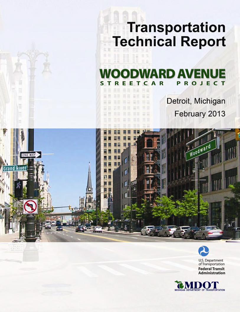
1.0 Introduction This Transportation Technical Report supports the Woodward Avenue Streetcar Supplemental Environmental Assessment (EA). It documents analyses of existing transportation conditions and future transportation conditions with and without the proposed Woodward Avenue Streetcar Project. The transportation elements addressed in the analyses include safety (traffic crashes), non-motorized mobility (pedestrian and bicycle), parking, existing and proposed transit operations, and traffic operations.
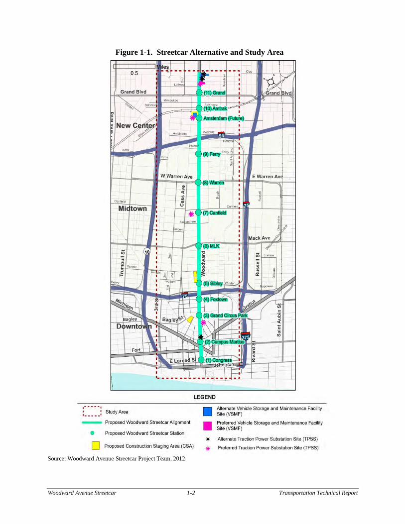
The transportation improvements proposed to address the identified purpose and need comprises a 3.3-mile, fixed-rail, at-grade streetcar system located entirely within the rights-of-way of Woodward Avenue (“the Project”). The Streetcar would operate in mixed traffic and run from Larned Street in Downtown Detroit (Downtown) north to Chandler Street/Delaware Street in New Center. Eleven stations comprising a mix of curbside and center platforms are proposed along the alignment; a potential twelfth station would coincide with the potential future relocation of the existing Amtrak station to the south of the existing railroad tracks. From Downtown Detroit to Burroughs Street, the streetcar would be curb-running, north of Burroughs, the streetcar would be median running. Figure 1-1 illustrates the proposed Streetcar Project and the Study Area.
The proposed streetcar is similar to Alternative B3 of the previous Woodward Avenue Light Rail Transit (LRT) project Final Environmental Impact Statement (FEIS) completed in June 2011, with a Record of Decision signed August 31, 2011. Due to similarities between the Streetcar project and the LRT project, the EA draws on pertinent data and analyses documented in the FEIS, which is available at http://www.mi.gov/woodwardstreetcar, or upon request. This report is a revision of the Transportation Technical Report developed for the FEIS. This report provides a summary of updates and new analyses completed for the Streetcar Alternative.
Woodward Avenue Streetcar 1-2 Transportation Technical Report
Figure 1-1. Streetcar Alternative and Study Area
Source: Woodward Avenue Streetcar Project Team, 2012
Woodward Avenue Streetcar 2-1 Transportation Technical Report
2.0 Existing Transportation Conditions This chapter summarizes existing transportation conditions within the study corridor, including transit and non-motorized conditions, the number and types of vehicle crashes, parking, and traffic conditions.
2.1 Transit Service, Safety, and Security
Service offerings and safety and security conditions for the Detroit Department of Transportation (DDOT), the Suburban Mobility Authority for Regional Transportation (SMART), Detroit Transportation Corporation (DTC), Transit Windsor, and other transit services have not changed significantly since the Woodward Avenue LRT FEIS. Updated ridership figures along the corridor are included in Chapter 3 of the Woodward Avenue Streetcar Environmental Assessment.
2.2 Non-Motorized Facilities and Safety
Non-motorized facilities and safety have not changed significantly since the Woodward Avenue LRT FEIS.
2.3 Parking
Parking availability along the Woodward Avenue changed slightly since the Woodward Avenue LRT FEIS. This section summarizes existing 2012 metered and non-metered parking within the study corridor. Table 2-1 summarizes the existing parking spaces along the proposed streetcar alignment.
Table 2-1. Estimated Parking Spaces along Woodward Avenue (2012)
Woodward Section
Metered/Non-Metered Parking Spaces by Direction*
Northbound Southbound TOTAL
Metered Non-metered* Metered Non-
metered* Metered Non-metered* Total
Larned Street to Campus Martius 3 0 0 0 3 0 3
Campus Martius to State 6 0 0 0 6 0 6
State to Adams 18 0 0 0 18 0 18 Adams to I-75 0 0 0 0 0 0 0
I-75 to Alexandrine 12 72 19 73 31 145 176 Alexandrine to Kirby 37 64 45 16 53 80 162
Kirby to Grand 35 27 40 30 67 57 132 Grand and Chandler 2 46 0 35 2 81 83
Total 113 209 104 154 209 363 572 Source: Parsons Brinckerhoff, 2012 * Non-metered space estimate based on an average length of 20 feet per space
Parking along Woodward Avenue within Downtown Detroit is generally one-hour to two-hour parking. North of Downtown, there are 209 existing metered parking spaces along Woodward Avenue from State Street to Chandler Street. The meters vary between one-hour and two-hour
Woodward Avenue Streetcar 2-2 Transportation Technical Report
parking. There is also 30-minute parking north of Parsons Street near the Max M. Fisher Theatre.
2.3.1 Parking Revenue Estimated parking revenue on Woodward Avenue changed slightly since the FEIS due to the number of meters changing along the corridor. The estimated revenue information was provided by the City of Detroit Municipal Parking Department. Approximate revenue per meter per day was provided for each street segment. This was based on information from 2009, but given that the rates and fees have not changed, these values are still applicable in 2013. Table 2-2 summarizes the approximate revenue generated from metered parking within the study corridor. The revenue includes money collected from meters and money collected for parking tickets as part of parking enforcement. For enforcement revenue, ticket information was provided for a one-year period and was averaged to a daily rate, which includes Sundays and holidays. Parking violations ranged from parking at an expired meter, which has a lower fine, to parking in a no parking zone, which has a higher fine.
Table 2-2. Estimated Daily Parking Revenue (2009)
Section Meters Enforcement Total
Larned to Campus Martius $57 $37 $94 Campus Martius - $2 $2
Campus Martius to State $102 $47 $149 State to Adams $306 $89 $395 Adams to I-75 - $8 $8
I-75 to Alexandrine $432 $165 $597 Alexandrine to Kirby $1,157 $281 $1,438
Kirby to Grand $1,076 $230 $1,306 Grand to Chandler $26 $10 $36
Total $3,156 $869 $4,025 Source: City of Detroit Municipal Parking Department, 2009
In 2009 – as well as today - all metered parking was charged at $1 per hour. The average revenue per day per meter ranges from $12 in the Medical Center area, $13 in the New Center area, $17 in Downtown, and $20 near Wayne State University. The revenue collected in 2009 from parking within the study corridor averaged $4,025 per day. The highest revenue-generating area is along Woodward Avenue between Alexandrine and Kirby Streets, which is in the Wayne State University area. The next highest revenue-generating area is along Woodward Avenue between Kirby Street and Grand Boulevard, which is in the New Center area.
For sections where there are meters, the average daily revenue ranged between $12 per meter per day to $20 per meter per day, with the average being $16 per meter per day.
2.3.2 Parking Utilization There were no changes to this section from the Woodward Avenue LRT FEIS.
2.4 Freight Movement
This remains unchanged as presented in the FEIS.
Woodward Avenue Streetcar 2-3 Transportation Technical Report
2.5 Emergency Vehicles
There were no changes to this section from the Woodward Avenue LRT FEIS.
2.6 Traffic Operations
There were no changes to this section from the Woodward Avenue LRT FEIS. All of the signalized intersections are operating at an acceptable level-of-service (LOS), except for the Eastbound Peterboro Street at Woodward Avenue, which operate at LOS E. This is due to the high cycle length along the corridor (120 seconds from start of green to start of green on Woodward Avenue) and the amount of time given to Peterboro Street (approximately 30 seconds) and the low number of vehicles on the eastbound approach.
The Project Team used VISSIM software to determine intersection delay, level of service and travel time. VISSIM is a microsimulation model, i.e., the movements and interactions of individual vehicles are explicitly modeled based on geometric parameters, traffic volumes, vehicle types, intersection control and driver behavior. The software determines average performance measures, such as vehicle delay, volume served, and travel time from the simulation.
The modeled vehicle travel time along Woodward Avenue between Congress Street and Grand Boulevard from the VISSIM model is summarized in Table 2-3 below.
Table 2-3. Modeled Existing Travel Time along Woodward Avenue
Section Travel Time
Southbound in AM Peak Hour
Northbound in PM Peak Hour
Congress Adams 2 min 46 sec 2 min 21 sec Adams MLK Jr./Mack 1 min 24 sec 1 min 39 sec
MLK Jr./Mack Warren 1 min 17 sec 1 min 31 sec Warren Grand Blvd 1 min 57 sec 2 min 1 sec
Total 7 min 24 sec 7 min 32 sec Average Speed 25 mph 25 mph
Source: Parsons Brinckerhoff, 2011
The average modeled travel time southbound along Woodward Avenue between Grand Boulevard and Adams Street in the AM peak hour is 7 minutes and 24 seconds. The PM peak-hour time for a northbound vehicle at the same location is 5 minutes and 11 seconds.
The average modeled travel speed along southbound Woodward Avenue between Grand Boulevard and Adams Street in the AM peak hour is 25 mph and also the same for northbound in the PM peak hour. This is for the distance 3.1 miles, between Grand Boulevard and Adams Street.

Woodward Avenue Streetcar 2-4 Transportation Technical Report
This page intentionally left blank.
Woodward Avenue Streetcar 3-1 Transportation Technical Report
3.0 Future Transportation Conditions This chapter summarizes the changes to the future (2030) transportation conditions in the study area with the Woodward Avenue Streetcar.
3.1 Future (2030) Transportation Patterns
There were no changes to this section from the Woodward Avenue LRT FEIS.
3.2 Future (2030) No Build Conditions
There were no changes to this section from the Woodward Avenue LRT FEIS.
3.3 Future (2030) Streetcar Alternative Conditions
This section summarizes future transportation conditions along Woodward Avenue that would result with implementation of the Streetcar Alternative.
3.3.1 Proposed Alignment, Operating Conditions and Station Locations This section of the report provides additional detail on the Streetcar Alternative along Woodward Avenue from downtown Detroit to Grand Boulevard in New Center. Woodward Avenue has two distinct cross-sections within the study area. Between Campus Martius and Park Avenue, Woodward Avenue has two lanes in each direction and metered parking located within curb cutouts on the northbound side of the street only. North of Park Avenue, Woodward Avenue has three to four through lanes in each direction and a continuous center left-turn only lane. Typically, the outside lane in both directions has either unrestricted parking or metered parking, reducing the number of through lanes to either two or three through lanes in each direction. The right-of-way within this section of Woodward Avenue is 120 feet.
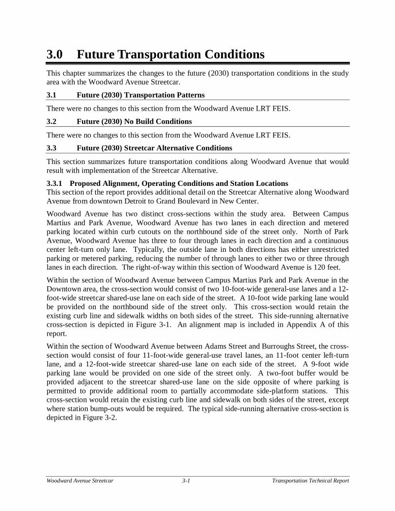
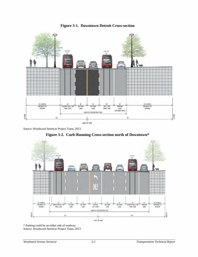
Within the section of Woodward Avenue between Campus Martius Park and Park Avenue in the Downtown area, the cross-section would consist of two 10-foot-wide general-use lanes and a 12-foot-wide streetcar shared-use lane on each side of the street. A 10-foot wide parking lane would be provided on the northbound side of the street only. This cross-section would retain the existing curb line and sidewalk widths on both sides of the street. This side-running alternative cross-section is depicted in Figure 3-1. An alignment map is included in Appendix A of this report. Within the section of Woodward Avenue between Adams Street and Burroughs Street, the cross-section would consist of four 11-foot-wide general-use travel lanes, an 11-foot center left-turn lane, and a 12-foot-wide streetcar shared-use lane on each side of the street. A 9-foot wide parking lane would be provided on one side of the street only. A two-foot buffer would be provided adjacent to the streetcar shared-use lane on the side opposite of where parking is permitted to provide additional room to partially accommodate side-platform stations. This cross-section would retain the existing curb line and sidewalk on both sides of the street, except where station bump-outs would be required. The typical side-running alternative cross-section is depicted in Figure 3-2.
Woodward Avenue Streetcar 3-2 Transportation Technical Report
Figure 3-1. Downtown Detroit Cross-section
Source: Woodward Streetcar Project Team, 2013
Figure 3-2. Curb-Running Cross-section north of Downtown*
* Parking could be on either side of roadway Source: Woodward Streetcar Project Team, 2013
Woodward Avenue Streetcar 3-3 Transportation Technical Report
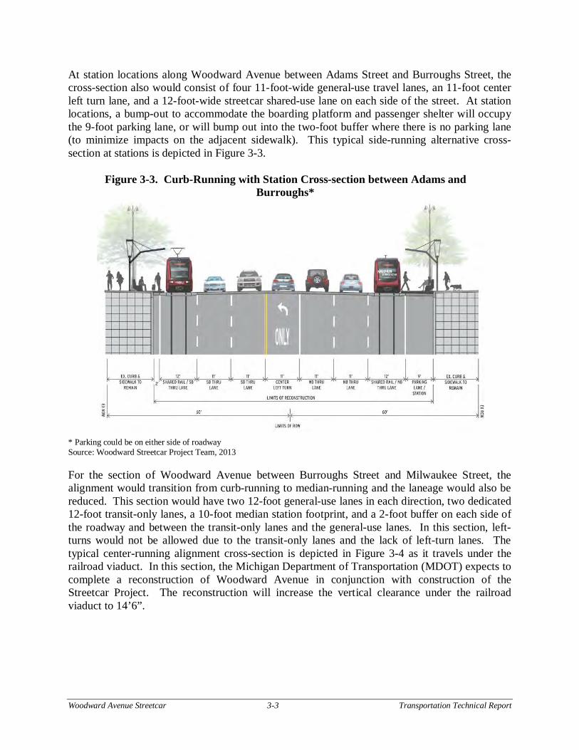
At station locations along Woodward Avenue between Adams Street and Burroughs Street, the cross-section also would consist of four 11-foot-wide general-use travel lanes, an 11-foot center left turn lane, and a 12-foot-wide streetcar shared-use lane on each side of the street. At station locations, a bump-out to accommodate the boarding platform and passenger shelter will occupy the 9-foot parking lane, or will bump out into the two-foot buffer where there is no parking lane (to minimize impacts on the adjacent sidewalk). This typical side-running alternative cross-section at stations is depicted in Figure 3-3.
Figure 3-3. Curb-Running with Station Cross-section between Adams and Burroughs*
* Parking could be on either side of roadway Source: Woodward Streetcar Project Team, 2013
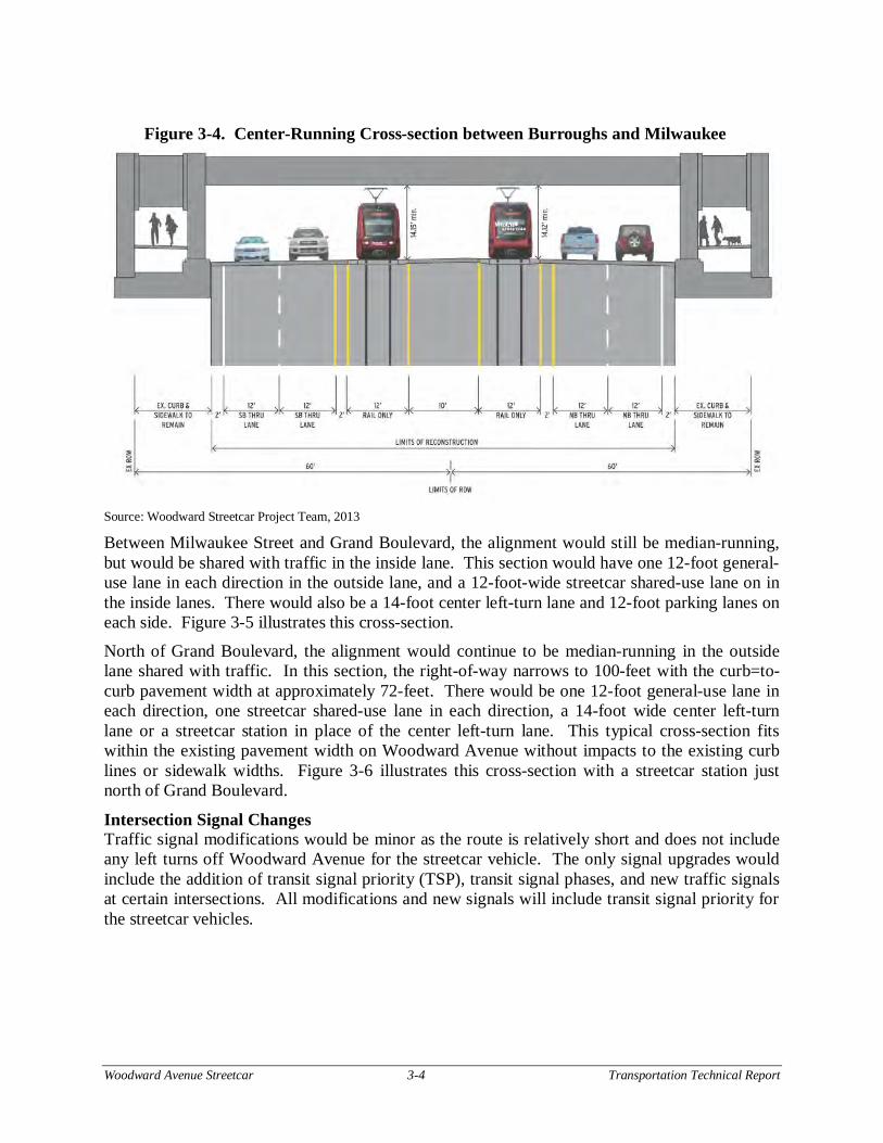
For the section of Woodward Avenue between Burroughs Street and Milwaukee Street, the alignment would transition from curb-running to median-running and the laneage would also be reduced. This section would have two 12-foot general-use lanes in each direction, two dedicated 12-foot transit-only lanes, a 10-foot median station footprint, and a 2-foot buffer on each side of the roadway and between the transit-only lanes and the general-use lanes. In this section, left-turns would not be allowed due to the transit-only lanes and the lack of left-turn lanes. The typical center-running alignment cross-section is depicted in Figure 3-4 as it travels under the railroad viaduct. In this section, the Michigan Department of Transportation (MDOT) expects to complete a reconstruction of Woodward Avenue in conjunction with construction of the Streetcar Project. The reconstruction will increase the vertical clearance under the railroad viaduct to 14’6”.
Woodward Avenue Streetcar 3-4 Transportation Technical Report
Figure 3-4. Center-Running Cross-section between Burroughs and Milwaukee
Source: Woodward Streetcar Project Team, 2013
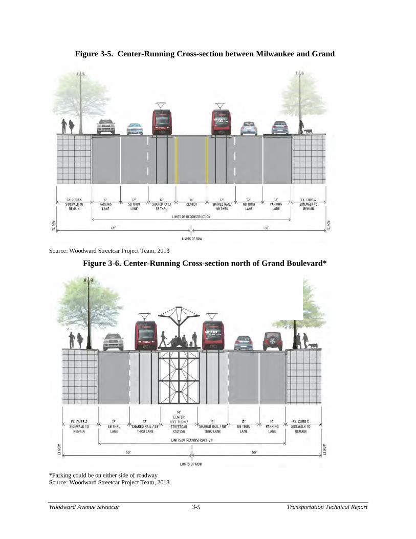
Between Milwaukee Street and Grand Boulevard, the alignment would still be median-running, but would be shared with traffic in the inside lane. This section would have one 12-foot general-use lane in each direction in the outside lane, and a 12-foot-wide streetcar shared-use lane on in the inside lanes. There would also be a 14-foot center left-turn lane and 12-foot parking lanes on each side. Figure 3-5 illustrates this cross-section.
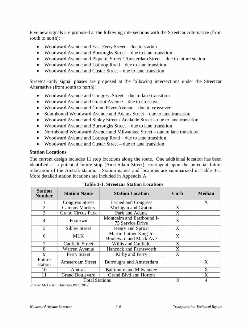
North of Grand Boulevard, the alignment would continue to be median-running in the outside lane shared with traffic. In this section, the right-of-way narrows to 100-feet with the curb=to-curb pavement width at approximately 72-feet. There would be one 12-foot general-use lane in each direction, one streetcar shared-use lane in each direction, a 14-foot wide center left-turn lane or a streetcar station in place of the center left-turn lane. This typical cross-section fits within the existing pavement width on Woodward Avenue without impacts to the existing curb lines or sidewalk widths. Figure 3-6 illustrates this cross-section with a streetcar station just north of Grand Boulevard.
Intersection Signal Changes Traffic signal modifications would be minor as the route is relatively short and does not include any left turns off Woodward Avenue for the streetcar vehicle. The only signal upgrades would include the addition of transit signal priority (TSP), transit signal phases, and new traffic signals at certain intersections. All modifications and new signals will include transit signal priority for the streetcar vehicles.
Woodward Avenue Streetcar 3-5 Transportation Technical Report
Figure 3-5. Center-Running Cross-section between Milwaukee and Grand
Source: Woodward Streetcar Project Team, 2013
Figure 3-6. Center-Running Cross-section north of Grand Boulevard*
*Parking could be on either side of roadway Source: Woodward Streetcar Project Team, 2013
Woodward Avenue Streetcar 3-6 Transportation Technical Report
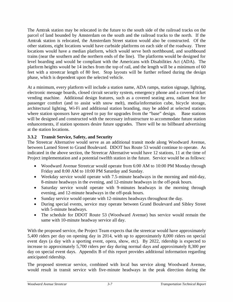
Five new signals are proposed at the following intersections with the Streetcar Alternative (from south to north):
Woodward Avenue and East Ferry Street – due to station Woodward Avenue and Burroughs Street – due to lane transition Woodward Avenue and Piquette Street / Amsterdam Street – due to future station Woodward Avenue and Lothrop Road – due to lane transition Woodward Avenue and Custer Street – due to lane transition
Streetcar-only signal phases are proposed at the following intersections under the Streetcar Alternative (from south to north):
Woodward Avenue and Congress Street – due to lane transition Woodward Avenue and Gratiot Avenue – due to crossover Woodward Avenue and Grand River Avenue – due to crossover Southbound Woodward Avenue and Adams Street – due to lane transition Woodward Avenue and Sibley Street / Adelaide Street – due to lane transition Woodward Avenue and Burroughs Street – due to lane transition Northbound Woodward Avenue and Milwaukee Street – due to lane transition Woodward Avenue and Lothrop Road – due to lane transition Woodward Avenue and Custer Street – due to lane transition
Station Locations The current design includes 11 stop locations along the route. One additional location has been identified as a potential future stop (Amsterdam Street), contingent upon the potential future relocation of the Amtrak station. Station names and locations are summarized in Table 3-1. More detailed station locations are included in Appendix A.
Table 3-1. Streetcar Station Locations Station
Number Station Name Station Location Curb Median
1 Congress Street Larned and Congress X 2 Campus Martius Michigan and Gratiot X 3 Grand Circus Park Park and Adams X 4 Foxtown Montcalm and Eastbound I-
75 Service Drive X
5 Sibley Street Henry and Sproat X 6 MLK Martin Luther King Jr.
Boulevard and Mack Ave X 7 Canfield Street Willis and Canfield X 8 Warren Avenue Hancock and Farnsworth X 9 Ferry Street Kirby and Ferry X
Future station Amsterdam Street Burroughs and Amsterdam X
10 Amtrak Baltimore and Milwaukee X 11 Grand Boulevard Grand Blvd and Horton X
Total Stations 8 4 Source: M-1 RAIL Business Plan, 2012
Woodward Avenue Streetcar 3-7 Transportation Technical Report
The Amtrak station may be relocated in the future to the south side of the railroad tracks on the parcel of land bounded by Amsterdam on the south and the railroad tracks to the north. If the Amtrak station is relocated, the Amsterdam Street station would also be constructed. Of the other stations, eight locations would have curbside platforms on each side of the roadway. Three locations would have a median platform, which would serve both northbound, and southbound trains (near the southern and the northern ends of the line). The platforms would be designed for level boarding and would be compliant with the Americans with Disabilities Act (ADA). The platform heights would be 14 inches from the top of rail, and the length will be a minimum of 60 feet with a streetcar length of 80 feet. Stop layouts will be further refined during the design phase, which is dependent upon the selected vehicle.
At a minimum, every platform will include a station name, ADA ramps, station signage, lighting, electronic message boards, closed circuit security system, emergency phone and a covered ticket vending machine. Additional design features, such as a covered seating area, radiant heat for passenger comfort (and to assist with snow melt), media/information cube, bicycle storage, architectural lighting, Wi-Fi and additional station branding, may be added at selected stations where station sponsors have agreed to pay for upgrades from the “base” design. Base stations will be designed and constructed with the necessary infrastructure to accommodate future station enhancements, if station sponsors desire future upgrades. There will be no billboard advertising at the station locations.
3.3.2 Transit Service, Safety, and Security The Streetcar Alternative would serve as an additional transit mode along Woodward Avenue, between Larned Street to Grand Boulevard. DDOT bus Route 53 would continue to operate. As indicated in the above section, the Streetcar Alternative would have 12 stations, 11 at the time of Project implementation and a potential twelfth station in the future. Service would be as follows:
Woodward Avenue Streetcar would operate from 6:00 AM to 10:00 PM Monday through Friday and 8:00 AM to 10:00 PM Saturday and Sunday.
Weekday service would operate with 7.5-minute headways in the morning and mid-day, 8-minute headways in the evening, and 12-minute headways in the off-peak hours.
Saturday service would operate with 9-minutes headways in the morning through evening, and 12-minute headways in the off-peak hours.
Sunday service would operate with 12-minutes headways throughout the day. During special events, service may operate between Grand Boulevard and Sibley Street
with 5-minute headways. The schedule for DDOT Route 53 (Woodward Avenue) bus service would remain the
same with 10-minute headway service all day.
With the proposed service, the Project Team expects that the streetcar would have approximately 5,400 riders per day on opening day in 2014, with up to approximately 8,000 riders on special event days (a day with a sporting event, opera, show, etc). By 2022, ridership is expected to increase to approximately 5,700 riders per day during normal days and approximately 8,300 per day on special event days. Appendix B of this report provides additional information regarding anticipated ridership. The proposed streetcar service, combined with local bus service along Woodward Avenue, would result in transit service with five-minute headways in the peak direction during the
Woodward Avenue Streetcar 3-8 Transportation Technical Report
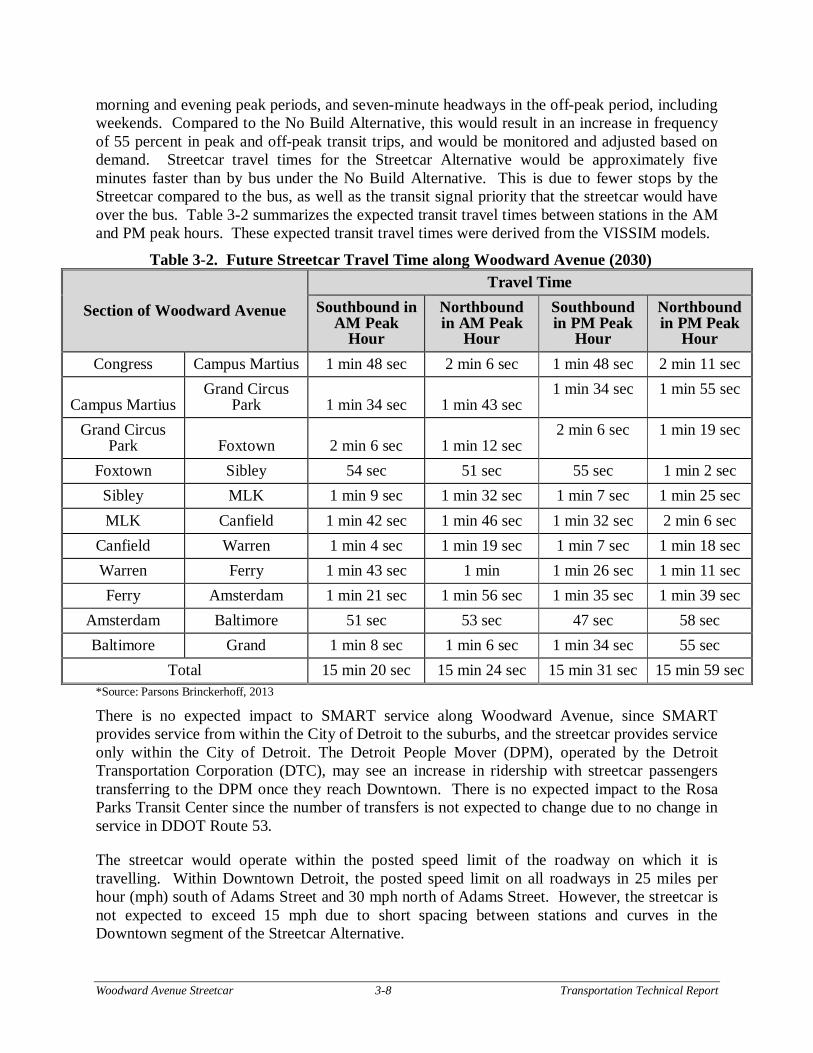
morning and evening peak periods, and seven-minute headways in the off-peak period, including weekends. Compared to the No Build Alternative, this would result in an increase in frequency of 55 percent in peak and off-peak transit trips, and would be monitored and adjusted based on demand. Streetcar travel times for the Streetcar Alternative would be approximately five minutes faster than by bus under the No Build Alternative. This is due to fewer stops by the Streetcar compared to the bus, as well as the transit signal priority that the streetcar would have over the bus. Table 3-2 summarizes the expected transit travel times between stations in the AM and PM peak hours. These expected transit travel times were derived from the VISSIM models.
Table 3-2. Future Streetcar Travel Time along Woodward Avenue (2030)
Section of Woodward Avenue
Travel Time Southbound in
AM Peak Hour
Northbound in AM Peak
Hour
Southbound in PM Peak
Hour
Northbound in PM Peak
Hour Congress Campus Martius 1 min 48 sec 2 min 6 sec 1 min 48 sec 2 min 11 sec
Campus Martius Grand Circus
Park 1 min 34 sec 1 min 43 sec 1 min 34 sec 1 min 55 sec
Grand Circus Park Foxtown 2 min 6 sec 1 min 12 sec
2 min 6 sec 1 min 19 sec
Foxtown Sibley 54 sec 51 sec 55 sec 1 min 2 sec Sibley MLK 1 min 9 sec 1 min 32 sec 1 min 7 sec 1 min 25 sec MLK Canfield 1 min 42 sec 1 min 46 sec 1 min 32 sec 2 min 6 sec
Canfield Warren 1 min 4 sec 1 min 19 sec 1 min 7 sec 1 min 18 sec Warren Ferry 1 min 43 sec 1 min 1 min 26 sec 1 min 11 sec Ferry Amsterdam 1 min 21 sec 1 min 56 sec 1 min 35 sec 1 min 39 sec
Amsterdam Baltimore 51 sec 53 sec 47 sec 58 sec Baltimore Grand 1 min 8 sec 1 min 6 sec 1 min 34 sec 55 sec
Total 15 min 20 sec 15 min 24 sec 15 min 31 sec 15 min 59 sec *Source: Parsons Brinckerhoff, 2013 There is no expected impact to SMART service along Woodward Avenue, since SMART provides service from within the City of Detroit to the suburbs, and the streetcar provides service only within the City of Detroit. The Detroit People Mover (DPM), operated by the Detroit Transportation Corporation (DTC), may see an increase in ridership with streetcar passengers transferring to the DPM once they reach Downtown. There is no expected impact to the Rosa Parks Transit Center since the number of transfers is not expected to change due to no change in service in DDOT Route 53.
The streetcar would operate within the posted speed limit of the roadway on which it is travelling. Within Downtown Detroit, the posted speed limit on all roadways in 25 miles per hour (mph) south of Adams Street and 30 mph north of Adams Street. However, the streetcar is not expected to exceed 15 mph due to short spacing between stations and curves in the Downtown segment of the Streetcar Alternative.
Woodward Avenue Streetcar 3-9 Transportation Technical Report
Station design features would include lighting and security systems to enhance passenger safety and security. In case of emergency, the operator of the streetcar would notify a dispatcher, who would then notify city police, similar to the existing emergency procedures followed by bus operators. Local police would also patrol stations and vehicles. Informational and educational safety campaigns for drivers, students, pedestrians, cyclists, and transit users would begin prior to streetcar construction. The OCS will be designed for integration into the existing streetscape to minimize impacts by using joint use poles shared with streetlights where possible to minimize sidewalk and visual clutter.
3.3.3 Non-Motorized Facilities and Safety Non-Motorized Facilities The following is an overview of considerations for both pedestrians and cyclists conducted as part of this evaluation. Pedestrian Facilities
Pedestrian mobility within the Woodward Avenue corridor is largely defined by two key measures: continuity and widths of sidewalks, and designated locations to cross Woodward Avenue. The Streetcar Alternative is not expected to result in an increase in pedestrian crossing times across Woodward Avenue. In fact, the Streetcar Alternative would result in the addition of six signals along the corridor, thereby reducing pedestrian crossing times in some areas. The following intersections are proposed to have traffic signals installed:
Woodward Avenue and East Ferry Street – due to station Woodward Avenue and Burroughs Street – due to lane transition Woodward Avenue and Piquette Street / Amsterdam Street – due to future station Woodward Avenue and Lothrop Road – due to lane transition Woodward Avenue and Custer Street – due to lane transition
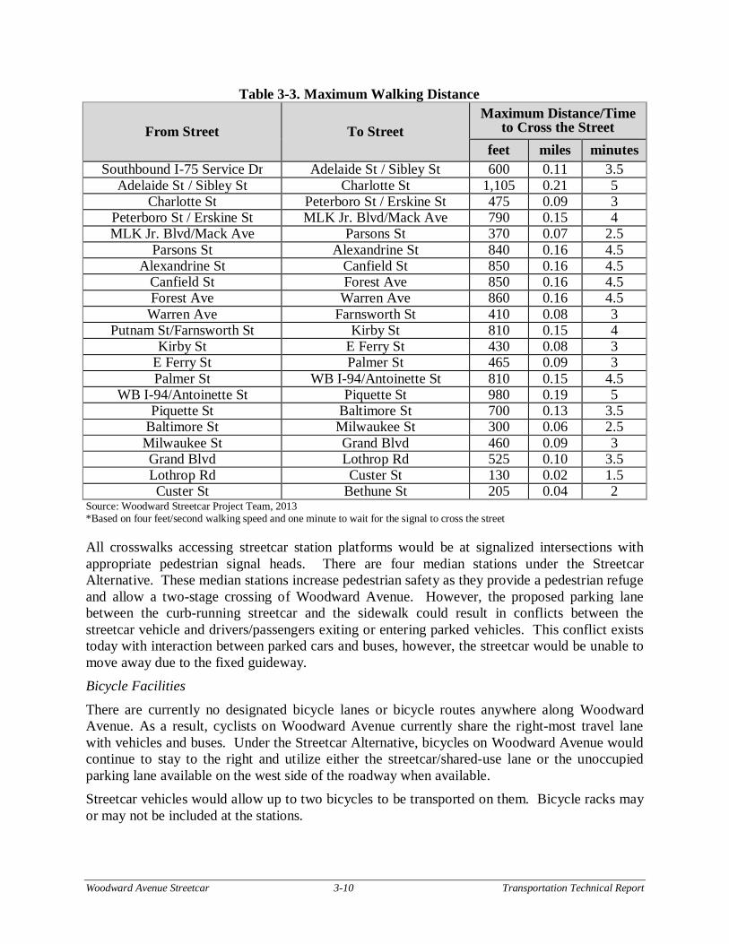
Three of the signals (Burroughs Street, Lothrop Road and Custer Street) are due to lane transitions for the streetcar. The other three signals are recommended to provide pedestrian access to the proposed station in those areas. The signal at Piquette Street / Amsterdam Street would only be installed when the station at Piquette Street / Amsterdam Street is built. All of these new signals would include signalized crosswalks, which reduces the overall distance for pedestrians to cross at a signalized intersection. Table 3-3 summarizes the distance and approximate walking time for a pedestrian to cross the street from mid-block on one side of Woodward Avenue to mid-block on the other side of Woodward Avenue.
Woodward Avenue Streetcar 3-10 Transportation Technical Report
Table 3-3. Maximum Walking Distance
From Street To Street Maximum Distance/Time
to Cross the Street feet miles minutes
Southbound I-75 Service Dr Adelaide St / Sibley St 600 0.11 3.5 Adelaide St / Sibley St Charlotte St 1,105 0.21 5
Charlotte St Peterboro St / Erskine St 475 0.09 3 Peterboro St / Erskine St MLK Jr. Blvd/Mack Ave 790 0.15 4 MLK Jr. Blvd/Mack Ave Parsons St 370 0.07 2.5
Parsons St Alexandrine St 840 0.16 4.5 Alexandrine St Canfield St 850 0.16 4.5
Canfield St Forest Ave 850 0.16 4.5 Forest Ave Warren Ave 860 0.16 4.5
Warren Ave Farnsworth St 410 0.08 3 Putnam St/Farnsworth St Kirby St 810 0.15 4
Kirby St E Ferry St 430 0.08 3 E Ferry St Palmer St 465 0.09 3 Palmer St WB I-94/Antoinette St 810 0.15 4.5
WB I-94/Antoinette St Piquette St 980 0.19 5 Piquette St Baltimore St 700 0.13 3.5
Baltimore St Milwaukee St 300 0.06 2.5 Milwaukee St Grand Blvd 460 0.09 3 Grand Blvd Lothrop Rd 525 0.10 3.5 Lothrop Rd Custer St 130 0.02 1.5 Custer St Bethune St 205 0.04 2
Source: Woodward Streetcar Project Team, 2013 *Based on four feet/second walking speed and one minute to wait for the signal to cross the street
All crosswalks accessing streetcar station platforms would be at signalized intersections with appropriate pedestrian signal heads. There are four median stations under the Streetcar Alternative. These median stations increase pedestrian safety as they provide a pedestrian refuge and allow a two-stage crossing of Woodward Avenue. However, the proposed parking lane between the curb-running streetcar and the sidewalk could result in conflicts between the streetcar vehicle and drivers/passengers exiting or entering parked vehicles. This conflict exists today with interaction between parked cars and buses, however, the streetcar would be unable to move away due to the fixed guideway. Bicycle Facilities
There are currently no designated bicycle lanes or bicycle routes anywhere along Woodward Avenue. As a result, cyclists on Woodward Avenue currently share the right-most travel lane with vehicles and buses. Under the Streetcar Alternative, bicycles on Woodward Avenue would continue to stay to the right and utilize either the streetcar/shared-use lane or the unoccupied parking lane available on the west side of the roadway when available. Streetcar vehicles would allow up to two bicycles to be transported on them. Bicycle racks may or may not be included at the stations.
Woodward Avenue Streetcar 3-11 Transportation Technical Report
Non-Motorized Safety The Streetcar Alternative is not expected to have any adverse impact on pedestrian safety in Downtown. Between I-75 and Burroughs Street, the curb-running streetcar is not expected to have an impact on pedestrian safety at unsignalized intersections, as all stations would be located at signalized intersections. Further, the number of signalized intersections between I-75 and Chandler Street/ Delaware Street would increase, thereby providing more opportunities for pedestrian crossings at controlled locations.
Bicycles on Woodward Avenue would utilize either the streetcar/shared-use lane or the unoccupied parking lane on one side when available. In the streetcar/shared-use lane, an open groove adjacent to the rail would be present to provide space for the wheel flange of the streetcar vehicles. If a bicycle were to cross the rail at a very small angle, there is potential for the front wheel to drop into the groove and cause the rider to lose balance. State-of-practice investigation indicates that bicyclists in areas with streetcar tracks in the rightmost lane are more likely to fall and be injured (ITE Journal, 2011). If possible, the use of bicycles in lanes with streetcar tracks should be discouraged. Placing signs along the roadway indicating the potential for the wheel to drop into the groove or locations of adjacent alternate routes could reduce this risk on Woodward Avenue. In addition, an educational campaign with the bicycling community to provide information on how to ride on the roadway with the streetcar and nearby alternate routes (Cass Avenue or John R Street) could also be beneficial to rider safety. For those riders that do continue to ride on Woodward Avenue, bicyclists will most likely avoid riding in the lane with the streetcar tracks due to the safety concerns.
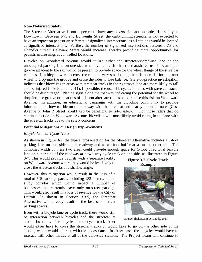
Potential Mitigations or Design Improvements Bicycle Lane or Cycle Track
As shown in Figure 3-2, the typical cross-section for the Streetcar Alternative includes a 9-foot parking lane on one side of the roadway and a two-foot buffer area on the other side. The combined width of these two areas could provide enough space for 5-foot directional bicycle lane on either side of the roadway or a two-way cycle track on one side, as illustrated in Figure 3-7. This would provide cyclists with a separate facility on Woodward Avenue where they would be less likely to cross the streetcar tracks at a shallow angle. However, this mitigation would result in the loss of a total of 545 parking spaces, including 182 meters, in the study corridor which would impact a number of businesses that currently have only on-street parking. This would also result in a loss of revenue for the City of Detroit. As shown in Section 3.3.5, the Streetcar Alternative will already result in the loss of on-street parking spaces. Even with a bicycle lane or cycle track, there would still be interaction between bicycles and the streetcar at station locations. The bicycle lane or cycle track either would either have to cross the streetcar tracks or would have to go on the other side of the station, which would interact with the pedestrians. In either case, the bicycles would have to interact with other modes at all of the curb-side stations. The Project Team will continue to
Figure 3-7. Cycle Track Example
Source: flicker.com/beyonddc, 2011
Woodward Avenue Streetcar 3-12 Transportation Technical Report
investigate state of the practice mitigation and design improvements during the design phase if this option is considered.
Alternative Routes There are a number of nearby parallel routes to Woodward Avenue along its corridor, including Cass Avenue and John R Street. One option to provide bicycle accommodations in the study corridor would be to provide bicycle facilities on these adjacent streets, rather than on Woodward Avenue. Cass Avenue may be a better alternative route for bicyclists since it has a direct connection to Downtown Detroit. In addition, the John R Street bridge over I-94 is proposed to be removed with the future reconstruction of I-94 in the study area. The Michigan Department of Transportation expects to reconstruct I-94 in the next 20 years.
While alternate routes would improve bicycle accommodation in the overall study corridor, these routes would not necessarily address safety concerns on Woodward Avenue. According to the State of Michigan Vehicle Code, bicycles would still be permitted on Woodward Avenue and would still be allowed to travel in the right-most lane. Some cyclists may opt to use the adjacent routes if bicycle lanes are added to parallel roadways. However, under State law, there is no way to enforce which roads cyclists choose to use.
Wayfinding signage could be placed along Woodward Avenue informing bicyclists of an alternate route one block away. In addition, wayfinding signage could be placed along Cass Avenue or John R Street informing bicyclists of popular destinations along Woodward Avenue. Alternative Rail Design
A special type of girder rail could be considered for use on this project, which has a smaller gap between the rail flange and the pavement. This rail design has the potential to reduce, but not eliminate, the danger of the flange gap for cyclists. However, this type of girder rail is not currently manufactured in the United States and would require a “Buy America” rule exception, which may not be feasible. While the potential may exist to special-order fabrication of the rail through a manufacturer in the United States, this option would be cost-prohibitive.
Education Program An educational program to advise cyclists on how to properly cross the tracks could be implemented during the construction phase by the Project Team. This may include public service announcements, workshops with local bicycling groups, and warning signs along the corridor.
3.3.4 Motor Vehicle Safety Along the corridor, the streetcar would either operate in the innermost or outermost lane mixed with traffic. There are no proposed changes to intersection operations, other than the addition of transit signal priority (TSP) at new signalized intersections and locations with addition of transit-only phases. As there would be no changes to vehicle-turning movements along roadways or at signalized intersections, no change in vehicle/vehicle crashes or vehicle/pedestrian crashes would be expected along the streetcar alignment.
With streetcar vehicles sharing a lane with motor vehicles, there is potential for conflicts between streetcar vehicles and motor vehicles. Motorists in the streetcar/shared-use lane may seek to quickly merge into the adjoining lane when a streetcar vehicle approaches from behind, increasing the potential for side-swipe and rear-end crashes. Motorists traveling in the lane
Woodward Avenue Streetcar 3-13 Transportation Technical Report
adjacent to the streetcar/shared-use lane may instinctively swerve away from a passing streetcar vehicle and into the adjoining lane, also increasing the potential for side-swipe crashes. There is also increased risk of rear-end and sideswipe crashes from motorists avoiding the streetcar vehicle stopped at a station. An informational campaign may be needed to inform drivers of the potential interaction between streetcar and other vehicles. There are two critical crash locations (the intersections of Woodward Avenue with Mack Avenue/MLK Jr. Boulevard and Warren Avenue) identified within the corridor. These locations are both due to cars turning left from the cross street onto Woodward Avenue. The Streetcar Alternative would not have an impact on these crashes. Construction of direct left-turn lanes from the cross street onto Woodward Avenue would mitigate these crashes.
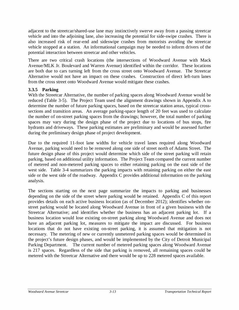
3.3.5 Parking With the Streetcar Alternative, the number of parking spaces along Woodward Avenue would be reduced (Table 3-5). The Project Team used the alignment drawings shown in Appendix A to determine the number of future parking spaces, based on the streetcar station areas, typical cross-sections and transition areas. An average parking-space length of 20 feet was used to calculate the number of on-street parking spaces from the drawings; however, the total number of parking spaces may vary during the design phase of the project due to locations of bus stops, fire hydrants and driveways. These parking estimates are preliminary and would be assessed further during the preliminary design phase of project development.
Due to the required 11-foot lane widths for vehicle travel lanes required along Woodward Avenue, parking would need to be removed along one side of street north of Adams Street. The future design phase of this project would determine which side of the street parking will retain parking, based on additional utility information. The Project Team compared the current number of metered and non-metered parking spaces to either retaining parking on the east side of the west side. Table 3-4 summarizes the parking impacts with retaining parking on either the east side or the west side of the roadway. Appendix C provides additional information on the parking analysis.
The sections starting on the next page summarize the impacts to parking and businesses depending on the side of the street where parking would be retained. Appendix C of this report provides details on each active business location (as of December 2012); identifies whether on-street parking would be located along Woodward Avenue in front of a given business with the Streetcar Alternative; and identifies whether the business has an adjacent parking lot. If a business location would lose existing on-street parking along Woodward Avenue and does not have an adjacent parking lot, measures to mitigate the impact are discussed. For business locations that do not have existing on-street parking, it is assumed that mitigation is not necessary. The metering of new or currently unmetered parking spaces would be determined in the project’s future design phases, and would be implemented by the City of Detroit Municipal Parking Department. The current number of metered parking spaces along Woodward Avenue is 217 spaces. Regardless of the side that parking is removed, all remaining spaces could be metered with the Streetcar Alternative and there would be up to 228 metered spaces available.
Woodward Avenue Streetcar 3-14 Transportation Technical Report
Table 3-4. Parking Spaces Retained with Streetcar Alternatives
* Total Parking (Metered / Non-Metered) Source: Woodward Avenue Streetcar Project Team, 2013
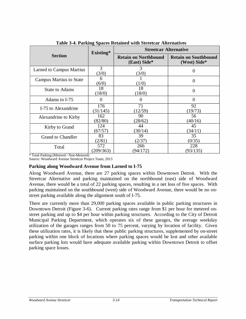
Parking along Woodward Avenue from Larned to I-75 Along Woodward Avenue, there are 27 parking spaces within Downtown Detroit. With the Streetcar Alternative and parking maintained on the northbound (east) side of Woodward Avenue, there would be a total of 22 parking spaces, resulting in a net loss of five spaces. With parking maintained on the southbound (west) side of Woodward Avenue, there would be no on-street parking available along the alignment south of I-75. There are currently more than 29,000 parking spaces available in public parking structures in Downtown Detroit (Figure 3-6). Current parking rates range from $1 per hour for metered on-street parking and up to $4 per hour within parking structures. According to the City of Detroit Municipal Parking Department, which operates six of these garages, the average weekday utilization of the garages ranges from 50 to 75 percent, varying by location of facility. Given these utilization rates, it is likely that these public parking structures, supplemented by on-street parking within one block of locations where parking spaces would be lost and other available surface parking lots would have adequate available parking within Downtown Detroit to offset parking space losses.
Section Existing*
Streetcar Alternative Retain on Northbound
(East) Side* Retain on Southbound
(West) Side* Larned to Campus Martius 3
(3/0) 3
(3/0) 0
Campus Martius to State 6 (6/0)
1 (1/0) 0
State to Adams 18 (18/0)
18 (18/0) 0
Adams to I-75 0 0 0
I-75 to Alexandrine 176 (31/145)
71 (12/59)
92 (19/73)
Alexandrine to Kirby 162 (82/80)
90 (28/62)
56 (40/16)
Kirby to Grand 124 (67/57)
44 (30/14)
45 (34/11)
Grand to Chandler 83 (2/81)
39 (2/37)
35 (0/35)
Total 572 (209/363)
266 (94/172)
228 (93/135)
Woodward Avenue Streetcar 3-15 Transportation Technical Report
Figure 3-7. Existing Parking Structures Located Within Downtown Detroit
Source: Downtown Detroit Transportation Master Plan, 2004
Parking along Woodward Avenue from I-75 to Alexandrine Within this section of Woodward Avenue, there are currently 176 parking spaces, of which 31 are metered. With parking maintained on the northbound (east) side of Woodward Avenue, the Project Team anticipates that 105 parking spaces would need to be removed between I-75 and Alexandrine Street, leaving 72 spaces. There are currently 16 active businesses and one currently ongoing construction site located on the west side of Woodward Avenue. All of the businesses on the west side of Woodward Avenue would lose on-street parking. However, 11 of them have an adjacent parking lot or near-by structure; therefore, there would be no long-term parking-related impact to these businesses. The six impacted businesses near Charlotte Street and Peterboro Street include two retail stores, a convenience store, check cashing service, laundromat, and a flower shop. There are currently 22 unmetered parking spaces located in the two blocks of Woodward Avenue where these businesses are located. Parking is allowed on Charlotte Street and Peterboro Street west of Woodward Avenue and is also unmetered. Mitigation for these lost spaces on Woodward Avenue in front of these businesses could be provided by metering of at least 22 parking spaces along Charlotte and Peterboro streets. Replacing unmetered parking with metered parking causes the space to be available more often and discourages all-day parking at an unmetered parking space. The metering of these spaces is shorter in duration (e.g., one hour) to encourage more turnover of the spaces for these businesses. These businesses and the proposed mitigation are described in detail in Appendix C.
Woodward Avenue Streetcar 3-16 Transportation Technical Report
With parking maintained on the southbound (west) side of Woodward Avenue, there would be a loss of 84 spaces, leaving 92 spaces in this section. There are currently nine active businesses and one medical office building on the east side of Woodward Avenue in this area. All of these businesses would lose on-street parking. However, they all have an adjacent parking lot or nearby structure; therefore there would be no long-term parking-related impacts to these businesses.
Parking along Woodward Avenue from Alexandrine to Kirby Street Within this section, there are currently 162 parking spaces, 82 of which are metered. With parking maintained on the northbound (east) side of Woodward Avenue, 72 parking spaces would be removed, leaving at total of 90 spaces. There are 18 active businesses on the west side of Woodward Avenue, all of which have access to adjacent parking lots or structures.
With parking maintained on the southbound (west) side of Woodward Avenue, 106 parking spaces would be removed, leaving a total of 56 spaces. There are currently 16 active businesses on the east side of Woodward Avenue in this area, all of which would lose on-street parking. Of the 16, 13 have an adjacent parking lot or nearby structure; therefore there would be no long-term parking-related impacts to these businesses. The three impacted businesses near East Willis Avenue are two restaurants and a telecommunications store. Mitigation for these lost spaces on Woodward Avenue in front of these businesses could be provided by metering of at least 10 parking spaces along East Willis Avenue. Replacing unmetered parking with metered parking causes the space to be available more often and discourages all-day parking at an unmetered parking space. The metering of these spaces is shorter in duration (e.g., one hour) to encourage more turnover of the spaces for these businesses. These businesses and the proposed mitigation are described in detail in Appendix C.
Parking along Woodward Avenue from Kirby to Grand There are currently 132 parking spaces in this section of Woodward Avenue, 75 of which are metered. Maintaining parking on the northbound (east) side of Woodward Avenue would result in the removal of 88 parking spaces in this section, leaving 44 spaces. There are six active businesses on the west side of Woodward Avenue in this section that would be impacted. However, all of the active businesses between Kirby Street and Grand Boulevard would have access to an adjacent parking lot.
Maintaining parking on the southbound (west) side of Woodward Avenue would result in the removal of 87 parking spaces, leaving 45 available spaces. There are 23 active businesses on the east side of Woodward Avenue in this section that would be impacted. Of the 23 businesses, all but six have adjacent off-street parking or a nearby structure. One business currently does not have on-street parking and utilizes side-street parking only. The remaining five impacted businesses include two retail stores, two clothing stores, and a furniture rental business located near Grand Boulevard. Within a quarter-mile of these businesses are two public parking structures and on-street parking available on other roadways, including Baltimore Street, Milwaukee Street, and Grand Boulevard. Therefore, no mitigation is proposed.
Woodward Avenue Streetcar 3-17 Transportation Technical Report
Parking along Woodward Avenue from Grand Boulevard to Chandler Street / Delaware Street There are currently 83 parking spaces along Woodward Avenue in this section, with two of those being metered parking spaces. Maintaining parking on the northbound (east) side of Woodward Avenue would eliminate 44 on-street parking on the west side of the street in this section. There are currently three active businesses located on the west side of Woodward Avenue in this area. All of the businesses on the west side of Woodward Avenue have an adjacent parking lot and, therefore, would have no long-term parking-related impact. Maintaining parking on the southbound (west) side of Woodward Avenue would eliminate 48 on-street parking spaces on the east side of the street in this section. There are seven active businesses on the east side of Woodward Avenue in this section, all of which have an adjacent parking lot. No long-term parking-related impacts are expected.
3.3.6 Freight Movement
Trucking and Deliveries Recent traffic counts indicate that commercial vehicles account for an average of about three percent of traffic on roadways in Downtown Detroit. Much of this is delivery traffic for Downtown businesses and is characterized by smaller delivery trucks. The addition of a streetcar would not decrease any of the existing curb radii, meaning that commercial vehicles would be able to complete the same turns that they are able to today. Right and left-turning analysis with commercial vehicles would be completed during the design phase of project development to verify that these vehicles would be able to complete these movements.
Generally, deliveries along the roadways with the outside streetcar/shared-use lane would be prohibited where there is not a parking lane. Deliveries would be restricted all day along Woodward Avenue between Congress Street to Adams Street. Between Adams Street to Grand Boulevard, deliveries would be restricted on the side of the roadway where a parking lane is not available. Deliveries would be allowed along the west side of the roadway where a parking lane exists. North of Grand Boulevard, deliveries would be restricted on both sides of the roadway. Given the removal of approximately 48 percent of the on-street parking on Woodward Avenue, there may be a negative impact to some businesses that receive their deliveries on Woodward Avenue. Mitigation measures may include allowing night-time deliveries to affected business locations.
Passenger / Freight Railroads Woodward Avenue intersects with two grade-separated rail lines at two bridges near Piquette Street in Detroit. The two existing railroad bridges may need to be modified to accommodate the median-running operating option. Impacts of the Streetcar Alternative at these railroad bridge locations would be investigated in detail during the preliminary design phase of project development. The Project Team does not anticipate that passenger or freight service would be interrupted during construction of the Streetcar Alternative.
3.3.7 Emergency Vehicles There are three fire stations located either within Downtown Detroit or along the Woodward Avenue corridor to Chandler Street/Delaware Street. The location of Engine 1 is at 111 Montcalm Street, west of Park Avenue within Downtown Detroit. This firehouse is approximately one block from Woodward Avenue. Engine 5 is located at 433 West Alexandine
Woodward Avenue Streetcar 3-18 Transportation Technical Report
Street, approximately 0.21 miles west of Woodward Avenue and Cass Avenue. Engine 17 is located at 6100 Second Avenue, north of Burroughs Street. The firehouse is approximately 0.20 miles from Woodward Avenue. With the Streetcar Alternative, no signals would be removed and there would be no restrictions to turning movements to and from Woodward Avenue, therefore it is not expected that response times would increase. The Detroit Fire Department (DFD) indicated that fire trucks must be situated approximately 20 feet from a building face to raise the ladder to access windows on the building face. Given a typical sidewalk width of 15 feet in Downtown and a typical sidewalk width of ten to 15 feet between I-75 and Burroughs Street, a fire truck would need to occupy either a portion or all of the streetcar/shared-use lane to respond to an incident. In this instance, the catenary wire for the streetcar would need to be disabled. This would result in an impact to streetcar operations during any kind of fire event that requires use of a ladder truck along the alignment along Woodward Avenue. There are several major hospitals with emergency room within the study corridor. Given that there are no changes to signalized intersections or turning movements along the corridor, there are no expected impacts to EMS along the corridor.
3.3.8 Traffic Operations Under the Streetcar Alternative, the number of travel lanes along Woodward Avenue would not change. However, lane width would be increased to 11 feet, and parking would be removed from one side of the street to accommodate the additional lane width. There would be turning movement restrictions in four locations, which are described below. All other turning movements at signalized and unsignalized intersections that are currently allowed would continue to be allowed for non-streetcar vehicles. Vehicle mix along the Woodward Avenue Corridor is not expected to change under this alternative. Proposed intersection operations with the streetcar, the use of TSP, and traffic operations are discussed below.
Methodology For purposes of a conservative analysis, the Project Team assumed that all traffic currently along Woodward Avenue would maintain current traffic patterns, and would not divert to other roadways or switch mode from automobile to streetcar. Therefore, the non-streetcar traffic volumes projected for the 2030 No Build Alternative were used in the evaluation of conditions with the Streetcar Alternative. This represents a “worst-case” scenario, as most roadways adjacent to the alignment have additional capacity to accommodate diverted trips. Streetcar-only signal phases and new signal locations are summarized in Section 3.3.1. Due to either station locations or the northern transition from northbound to southbound streetcar operation, the following turning movements would be restricted with the streetcar (from south to north):
Northbound Woodward Avenue to westbound Amsterdam Street would be restricted due to the future Amsterdam Station’s location in the center left-turn lane south of Piquette Street and well as the dedicated transit-only lane. With the new station and transit-only lane, northbound vehicles on Woodward Avenue would not be able to access the left-turn lane. Vehicles wishing to make a left turn would have to turn left at Burroughs Street, which is one street to the south, or at Baltimore Street, which is one street to the north.
Woodward Avenue Streetcar 3-19 Transportation Technical Report
Southbound Woodward Avenue to eastbound Piquette Street would be restricted due to the dedicated transit-only lane in the median. With the transit-only lane, southbound vehicles on Woodward Avenue would not be able to access the left-turn lane. Vehicles wishing to make a left turn would have to turn left at Milwaukee Street to the north, or Harper Street, which, is one street to the south.
Northbound Woodward Avenue to westbound Baltimore Street would be restricted to the median dedicated transit-only lane. With the transit-only lane, northbound vehicles on Woodward Avenue would not be able to access the left-turn lane. Vehicle wishing to make a left-turn would have to turn left at Milwaukee Street to the north or Burroughs Street to the south.
Southbound Woodward Avenue to eastbound Baltimore Street would be restricted due to the Baltimore Station’s location in the median north of Baltimore Street as well as the dedicated transit-only lane. With the new station and the transit-only lane, southbound vehicles on Woodward Avenue would not be able to access the left-turn lane. Vehicles wishing to make a left turn would have to turn left at Milwaukee Street, which is one street to the north, or at Harper Street, which is three streets to the south.
Southbound Woodward Avenue to eastbound Custer Street would be restricted due to the Streetcar’s transition from northbound to southbound, using the center left-turn lane for the transition. With the location of the switch, the center left-turn lane between Custer and Bethune streets would be restricted for Streetcar use. Other vehicles wishing to make a left-turn would have to turn left at Bethune Street or at Horton Street, which is one street to the south.
Northbound Woodward Avenue to westbound Bethune Street would be restricted due to Streetcar transition from northbound to southbound utilizing the center left-turn lane for the transition. With the location of the switch, the center left-turn lane between Custer Street and Bethune Street would be restricted to Streetcar vehicles only. Vehicles wishing to make a left-turn would either have to turn left at Lothrop Road, which is one street south, or at Pallister Street (depending on the VSMF site chosen), which is one street to the north.
Traffic volumes used to evaluate the Streetcar Alternative along Woodward Avenue are based on the 2030 No Build traffic volumes, but were modified to include the above turning movement restrictions (Appendix D of this report).
Transit Signal Priority (TSP) New signals along the corridor will have transit signal priority, as well as any signals that need transit only phases (M1-Rail, 2012). No other signals will have transit signal priority.
Traffic Conditions The AM and PM peak-hour operational results (level of service and delay) from the VISSIM models for all the signalized intersections with the Streetcar Alternative summarized in Appendix D.
Signal operations assumed with the Streetcar Alternative would remain essentially the same as in current operations but with the addition of TSP, as described. The modeled signal timings were updated with a cycle length of 120 seconds and the amount of green time given to each approach was revised. Minimum pedestrian timings were maintained for all signalized intersections.
Woodward Avenue Streetcar 3-20 Transportation Technical Report
All intersections and approaches would operate with an overall LOS D or better during the AM and PM peak hours with the Streetcar Alternative.
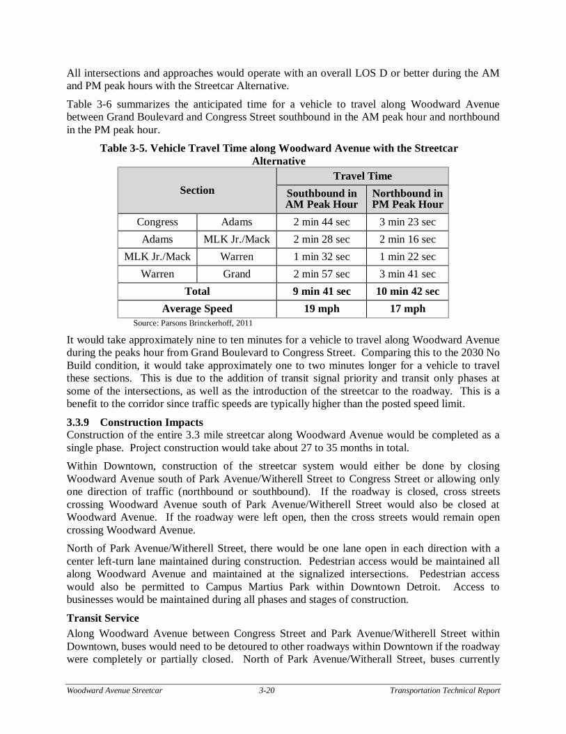
Table 3-6 summarizes the anticipated time for a vehicle to travel along Woodward Avenue between Grand Boulevard and Congress Street southbound in the AM peak hour and northbound in the PM peak hour.
Table 3-5. Vehicle Travel Time along Woodward Avenue with the Streetcar Alternative
Section Travel Time
Southbound in AM Peak Hour
Northbound in PM Peak Hour
Congress Adams 2 min 44 sec 3 min 23 sec Adams MLK Jr./Mack 2 min 28 sec 2 min 16 sec
MLK Jr./Mack Warren 1 min 32 sec 1 min 22 sec Warren Grand 2 min 57 sec 3 min 41 sec
Total 9 min 41 sec 10 min 42 sec Average Speed 19 mph 17 mph
Source: Parsons Brinckerhoff, 2011
It would take approximately nine to ten minutes for a vehicle to travel along Woodward Avenue during the peaks hour from Grand Boulevard to Congress Street. Comparing this to the 2030 No Build condition, it would take approximately one to two minutes longer for a vehicle to travel these sections. This is due to the addition of transit signal priority and transit only phases at some of the intersections, as well as the introduction of the streetcar to the roadway. This is a benefit to the corridor since traffic speeds are typically higher than the posted speed limit.
3.3.9 Construction Impacts Construction of the entire 3.3 mile streetcar along Woodward Avenue would be completed as a single phase. Project construction would take about 27 to 35 months in total. Within Downtown, construction of the streetcar system would either be done by closing Woodward Avenue south of Park Avenue/Witherell Street to Congress Street or allowing only one direction of traffic (northbound or southbound). If the roadway is closed, cross streets crossing Woodward Avenue south of Park Avenue/Witherell Street would also be closed at Woodward Avenue. If the roadway were left open, then the cross streets would remain open crossing Woodward Avenue. North of Park Avenue/Witherell Street, there would be one lane open in each direction with a center left-turn lane maintained during construction. Pedestrian access would be maintained all along Woodward Avenue and maintained at the signalized intersections. Pedestrian access would also be permitted to Campus Martius Park within Downtown Detroit. Access to businesses would be maintained during all phases and stages of construction.
Transit Service Along Woodward Avenue between Congress Street and Park Avenue/Witherell Street within Downtown, buses would need to be detoured to other roadways within Downtown if the roadway were completely or partially closed. North of Park Avenue/Witherall Street, buses currently
Woodward Avenue Streetcar 3-21 Transportation Technical Report
utilize the parking lane for bus stops. In those areas, buses would stop along the one travel lane and a clear accessible path should be maintained from the sidewalk through the construction zone. In areas where construction would prevent buses from pulling into existing stops, bus stops would be relocated outside the immediate construction zone and a clear accessible path from the sidewalk through the construction zone would be maintained. Construction of station platforms adjacent to the existing sidewalks may necessitate shifts in bus stop locations. Where temporary detours or stop relocations are necessary, DDOT and/or SMART would issue a Rider Alert, which would be posted at affected stops, on buses, at schedule distribution outlets and on the DDOT and/or SMART website. In addition, existing traffic patterns would be affected during construction, which could result in longer travel times and temporary detours for some bus routes.
Motor Vehicle and Non-Motorized Within Downtown Detroit, traffic along Woodward Avenue between Congress Street and Park Avenue/Witherell Street would need to be detoured to other roadways within Downtown if the roadway were completely or partially closed. These roadways would include Washington Boulevard, Broadway Street, and Randolph Street. For the complete closure, vehicles wishing to cross from the east side of Downtown to the west side of Downtown could utilize Park Avenue/Witherell Street, Adams Street, Larned Street, and Jefferson Avenue. All of these roadways currently have enough capacity to handle the traffic utilizing Woodward Avenue and the roadways crossing Woodward Avenue. As a result of a complete or partial closure within Downtown and the lane closures north of Downtown, existing traffic patterns would be affected during construction, which could result in longer travel times for motor vehicles.
With construction of curb-running stations within Downtown and along Woodward Avenue south of Piquette Street, construction fencing would be placed between the construction zone and the adjoining sidewalk. At curbside streetcar stops under construction, a through path would be maintained along the sidewalk behind the construction zone. Cyclists would continue to ride in the rightmost traffic lane. Construction would likely result in reduced vehicle travel speeds, allowing cyclists to mix with vehicle traffic more safely.
Crosswalks across Woodward Avenue may need to be closed at signalized intersections while center stations and tracks are constructed. Construction would be staged so that at least one crosswalk would be maintained at each signalized intersection location and signage would be placed to guide pedestrians to available crossing locations.
Parking Within Downtown, construction of the streetcar would cause the temporary loss of all parking along Woodward Avenue. There is one parking garage located off of Grand River Avenue west of Woodward Avenue that would be impacted by the complete closure of Woodward Avenue. This garage only has access to Grand River Avenue. Currently, Grand River Avenue is one-way eastbound within Downtown Detroit. Due to a complete closure of Woodward Avenue only (not the partial closure), vehicles would be able to access the parking garage, but would not be able to leave due to Grand River Avenue being one-way eastbound and the roadway being closed at Woodward Avenue. As a result, Grand River Avenue would need to be converted to two-way between Griswold Street and Woodward Avenue, at a minimum, with a complete closure of
Woodward Avenue Streetcar 3-22 Transportation Technical Report
Woodward Avenue for the construction of the streetcar within Downtown to allow vehicles to leave the garage.
Construction of the streetcar along Woodward Avenue north of Downtown would entail closing half of Woodward Avenue. One travel lane along Woodward Avenue would be maintained in each direction, and left-turn lanes would be maintained at signalized intersections. Left-turn access at unsignalized intersections and driveways may not be maintained; however, right-turn access would be maintained. On-street parking may be feasible between signalized intersections on the side of the roadway where traffic is maintained. On-street parking on the other side would not be maintained. Once construction of the southbound side of the roadway commences, on-street parking on that side of the roadway would be removed permanently.
Deliveries would be prohibited along all roadways with active construction.
3.3.10 Other Impacts This section of the report discusses other impacts that relate to the Streetcar Alternative.
Driveway Impacts at Station Locations on Woodward Avenue Under the Streetcar Alternative, two driveways would need be removed north the Adams Street to accommodate proposed stations:
Southbound Woodward Avenue station at Foxtown, south of I-75 Southbound Woodward Avenue station at MLK, south of MLK / Mack Avenue
In both locations, the existing driveways lead to a vacant parcel. During construction, the driveway permits for these locations should be revoked.
Snow Removal The streetcar vehicles would be capable of running in snow, as they will push snow from the tracks. The process to remove snow from vehicle travel lanes would not change from existing conditions. The streetcar/shared-use lane would need to be plowed in order to accommodate motor vehicles. Snow from travel lanes should not be piled at station locations due to ADA requirements, so some snow hauling may be necessary to keep these areas clear.
The Americans with Disabilities Act (ADA) On July 26, 1990, the Americans with Disabilities Act was signed into law. This legislation assures that a disabled person will have full access to all of the benefits and facilities within the United States. Codes and standards now regulate the design of sidewalks, placement of street furniture, curb cuts, ramps, transit vehicles, transit stops, signing, and construction sites. As part of the future design phase of this project, all elements of the design and streetcars will be fully ADA compliant unless it is structurally impracticable to do so. Full compliance will be considered structurally impracticable when the characteristics of the terrain prevent the incorporation of accessibility features. Sidewalks will be a minimum of five-feet wide, as indicated by the American Association of State Highway Transportation Officials (AASHTO), to ensure accommodation of wheelchair users. In addition, a minimum of five-feet will be provided within stations locations between any object in the station and the boarding area or curb. No protruding object should reduce the clear width of the circulation path to less than 36 inches.
Sidewalk ramps will have a maximum running slope of eight-percent, side flares (if applicable) not to exceed 10-percent, a five-foot square landing pad and tactile warning texture measuring 24 inches in height and extending the full width of the ramp. When five-foot minimum dimensions
Woodward Avenue Streetcar 3-23 Transportation Technical Report
are not feasible, ramp width may be reduced to not less than four-feet and landing dimension to not less than four-feet by four-feet. Handrails will be provided in areas of long ramps, greater than 30 feet and where ramp runs have a rise greater than 6 inches or a horizontal projection greater than 72 inches. There will be level boarding at all station locations with the streetcar, indicating that the curb height is generally around 14 inches to match the height of the streetcar. Within the streetcar vehicle, doorways will have a minimum of 32 inches wide when open and have priority seating signs. The horizontal gap between the streetcar vehicle and the platform shall be no greater than three inches and the height shall be within 5/8 inch of the platform height. At all doors on level-entry vehicles, handrails, stanchions, passenger seats, vehicle driver seat platforms, shall be located so as to allow a route at least 32 inches wide so that at least two wheelchair or mobility aid users can enter the vehicle and position the wheelchairs or mobility aids in areas, each having a minimum clear space of 48 inches by 30 inches, which do not unduly restrict movement of other passengers. There will be auditory and visual warning signals to alert passengers to when doors are closing. Accessible routes and curb cuts will be maintained at all construction and staging sites. Portable ramps will be placed at curbs when curb cuts are disrupted by construction.
Thanksgiving Parade America’s Thanksgiving Parade has been a yearly tradition since 1924 in Detroit and is the second oldest Thanksgiving Parade in the country. The parade occurs along Woodward Avenue and starts at Mack Avenue / MLK Jr. Boulevard and ends at Congress Street in Downtown Detroit. The parade is organized by The Parade Company, aka The Michigan Thanksgiving Parade Foundation, which is a not-for-profit, tax-exempt foundation. The parade has grown to include more than 75 parade units, including floats, balloons and marching bands, and is televised locally and nationally. For the majority of the years, the parade has been routed along sections of Woodward Avenue and varied either due to construction (Campus Martius Park, The People Mover) or due to the streetcars. For a period, the parade route moved to Second Avenue, due to the OCS wires in the middle of Woodward Avenue, which posed a hazard to floats and their riders. After the streetcars were removed in 1956, the Parade moved back to Woodward Avenue. In 1980, the city had to pay $36,000 to modify brand new street lights and traffic lights on Woodward so parade floats and balloons could get past. Although the parade was mentioned during planning sessions for the new fixtures, it was stated they would not interfere with the parade. It was subsequently determined that the fixtures were interfering, and 11 feet were later removed from the crossbars of nine signals. Every year, the Michigan Department of Transportation and the City of Detroit donate work force to disconnect the wires at all of the traffic signals that have span wire. For those signals that have mast-arms, they “swing” the mast arms out of the way for the balloons and floats. The balloons currently go either over or under the Detroit People Mover near Grand Circus Park. Beginning the day before the Parade, Woodward Avenue has partial closures between Warren and Jefferson avenues for the work done by MDOT and the City of Detroit on the traffic signals. The day of the parade, Woodward Avenue between Warren and Jefferson avenues is closed, however, busses are allowed in the closure. During construction of the streetcar, the Thanksgiving Parade would have to be moved to another roadway. After construction, the Parade could remain in its current location, along
Woodward Avenue Streetcar 3-24 Transportation Technical Report
Woodward Avenue between Mack Avenue / MLK Jr. Boulevard to Congress Street. The Parade could not occur north of Burroughs Street, since the streetcar would be center running. The power via the OCS to the streetcar would need to be turned off the day of the Parade to reduce hazard to the floats and balloons. Sections of the OCS wire may need to be removed at the intersection of Mack Avenue / MLK Jr. Blvd to allow the floats and balloons to get from Mack Avenue to Woodward Avenue. Sections of OCS wire would also have to be removed anywhere it crosses over Woodward Avenue from one side to the other side. This would occur near Adelaide Street, Gratiot Avenue, and Congress Street. The roadway narrows south of Park Avenue / Witherell Street in Downtown Detroit, indicating that the OCS wires would be closer to the parade and may cause more of a hazard. The parade may need to end north of Park Avenue / Witherell Street to reduce the hazard or could move to an adjacent facility within Downtown, such as Washington Boulevard. If there is off-wire technology within Downtown Detroit, then this could provide the opportunity for the parade to stay on Woodward Avenue south of Park Avenue / Witherell Street.
Long Term Construction Impacts to Woodward Avenue Future rehabilitation or reconstruction of the Woodward Avenue corridor after completion of the streetcar construction must consider maintenance of both automobile and streetcar traffic. While automobile traffic can be transitioned from lane to lane or detoured to other routes to accommodate construction activity, the streetcar operates on a fixed rail guideway, and options to transition or detour streetcar traffic are therefore limited. In general, for major reconstruction activities, it is proposed that part-width construction be utilized, with a minimum of one automobile travel lane in each direction on one side of the road, along with a single streetcar rail guideway maintained. Two-way streetcar traffic would be maintained on the single guideway through the use of strategically placed crossover rails and train signals installed during the initial construction. This operation would likely require prohibition of left turns along the corridor due to limited space to provide left-turn storage. Depending on the nature of the construction activity, it may not be possible to maintain streetcar traffic in one or both directions. In that case, operation of streetcar in the peak direction only may be considered, with enhanced bus operations serving the off-peak direction. In some cases, use of buses may be required to serve streetcar users should the streetcar need to be taken out of service entirely due to construction activities.
Signal Design This section provides a generalization of how the overhead catenary wire for the streetcar between I-75 and Chandler Street/Delaware Street and signal heads at signalized intersections would coexist. Within Downtown, all signalized intersections require mast arm mountings based on a City of Detroit ordinance. It is also proposed that within Downtown, off-wire technology may be used instead of the OCS. The placement of signal heads and their supporting mechanism would be constrained based on the location of and the required minimum offset from the catenary wire. The minimum height of the catenary wire is 17 feet for an alignment where streetcar is running in mixed traffic. In addition, an offset of six feet is required between the catenary wire and any other object. Given these requirements, a signal head mounted above the catenary would be required to have a minimum mounting height of 23 feet.
Woodward Avenue Streetcar 3-25 Transportation Technical Report
There are two options for signal head mounting: mast arms or span wires. Under a curb-running streetcar scenario, either of these options would require crossing over the catenary wires in order to secure the mast arm or span wire at the corner of the intersection outside of the traveled roadway.
Under a mast arm option, signal heads would be required to be set at a minimum of a 23-foot bottom height in order to achieve the minimum clearance from the catenary wires. In addition, given the three-degree rise of the arm, signal head placement would get progressively higher farther into the roadway. This is far in excess of MDOT’s preferred bottom height of 21 feet. Therefore, mast-arm signal design is not feasible with the Streetcar Alternative unless MDOT grants an exception to its typical signal design criteria, and after confirmation that required signal head visibility could be met at the higher mounting height. With span-wire installation, the wire that supports the signal heads going across Woodward Avenue would need to be a minimum of six feet above the catenary wire. However, the bottom of the signal head would still need to be 17 to 19 feet above the roadway to maintain proper visibility for motorists. Given a minimum span-wire height of 23 feet, and a typical signal-head height of three to four feet, extenders would be required of up to three feet in length to allow the signal head to hang further below the span wire in a position suitable for motorist visibility. Maintaining clearances and signal head visibility for drivers is not anticipated to be an issue using span-wire signal design. Therefore, at this point, the recommended signal design for the Streetcar Alternative is span wire.
North of Downtown, there is currently a mix of mast arms and span wire along Woodward Avenue. As part of the reconstruction of Woodward Avenue in this section, all signals are proposed to be modernized to a box span signal, indicating that the span wire is in a box around the intersection.
The details of signal design and configuration would be defined during the design phase of project development.
Bridge Overpass Configurations There are two bridges between I-75 and Grand Boulevard, which carry Woodward Avenue over the following freeways:
I-75 Fisher Freeway I-94 Ford Freeway
The bridge overpasses, which carry Woodward Avenue over I-75 and I-94, have a 90-foot curb-to-curb width and 15-foot-wide sidewalks on each side. There would be no parking allowed on either overpass. As a result, there would be five 12-foot-wide vehicular travel lanes including a continuous center left-turn-only lane. On the outside of the vehicular travel lanes would be a 13-foot-wide streetcar/shared lane in each direction. Finally, there would be a 2-foot-wide shy distance included between the streetcar/shared lane and the 15-foot-wide existing sidewalk.
The current SEMCOG Regional Transportation Plan includes expansion of I-94 between I-96 and Connor Avenue by one lane in each direction. The Woodward Avenue bridge over I-94 would need to be reconstructed to accommodate this widening.
Woodward Avenue Streetcar 3-26 Transportation Technical Report
3.3.11 Vehicle Storage and Maintenance Facility Sites The Project Team is considering four VSMF sites the Streetcar Alternative, one preferred site and three alternate sites. These sites and their impacts to the transportation system are listed below:
Preferred VSMF Site 1 - Custer Street Site – This preferred VSMF site is located east off of Woodward Avenue north of Custer Street. Streetcar vehicles would access the site from the center left-turn lane along Woodward Avenue between Custer Street and Bethune Street. There would be traffic signals located at the intersections of Lothrop Road, Custer Street, and Bethune Street to accommodate the safe passage of streetcar vehicles to access the VSMF. Operations of these signals would be determined during later stages of the project if this site is chosen. With this site, Bethune Street would be closed to through traffic between John R Street and Woodward Avenue.
Alternate VSMF Site 2 - Bethune Street Site – This alternate VSMF site is located east off of Woodward Avenue north of Bethune Street. Streetcar vehicles would access the site from the center left-turn lane along Woodward Avenue between Custer Street and Bethune Street. There would be traffic signals located at the intersections of Custer Street and Bethune Street to accommodate the safe passage of streetcar vehicles to access the VSMF. Again, operations of these signals would be determined during later stages of the project if this site is chosen.
Alternate VSMF Site 3 - Smith Street Site – This is the only potential site without frontage on Woodward Avenue, which is located east off of Woodward Avenue off of Smith Street. Streetcar vehicles would access the site from the center left-turn lane onto a driveway constructed in the former Smith Street right-of-way. There would be traffic signals located at the intersections of Custer Street and Bethune Street to accommodate the safe passage of streetcar vehicles to access the VSMF. Again, operations of these signals would be determined during later stages of the project if this site is chosen.
Alternate VSMF Site 4 - Amsterdam Street Site – This alternate site is located west of Woodward Avenue north of Amsterdam Street. Streetcar vehicles would access the site off Woodward Avenue at Amsterdam Street. There would be a traffic signal located at Woodward Avenue and Amsterdam Street / Piquette Street to accommodate the safe passage of streetcar vehicles to access the VSMF.
Woodward Avenue Streetcar 4-1 Transportation Technical Report
4.0 List of References Boorse, J., Hill, M., & Danaher, A. January 2011. General Design and Engineering Principles of
Streetcar Transit. ITE Journal, Volume 81 (1), 38-42. Michigan State Law Chapter 257. Act 300 (1949) (enacted). Amended 2010. State of Michigan
Vehicle Code. M-1 Rail. April 2012. M-1 Rail Streetcar Project Business Plan.

Woodward Avenue Streetcar 4-2 Transportation Technical Report
This page intentionally left blank.