Embed Size (px)
Citation preview
Woodlands Primary School
Geography Policy
Written by Eleanor Tucker and Suzy Hails-Wollen
Date for Review January 2020
Signed – Headteacher
This policy has been impact assessed by Mary Chatley in order to ensure that it does not have an adverse effect on race, gender or disability equality.
Woodlands Primary School – Geography Policy 2017
At Woodlands Primary School, we aim to inspire in pupils a curiosity and fascination about the world and its’ people that will remain with them for the rest of their lives. Our teaching aims to equip pupils with knowledge about diverse places, peoples, resources and environments; and foster within them a deepening understanding of the Earth’s key physical and human processes. As pupils progress through the school, their growing knowledge about the world helps them to deepen their understanding of the interactions between physical and human processes and the formation of landscapes and environments. Geographical knowledge enables children to describe how the Earth’s features at different scales are shaped, interconnected and change over time. Aims Following the National Curriculum, at Woodlands Primary we aim to:
develop knowledge of the location of places of global significance, their
defining physical and human characteristics and how they relate to one
another; this place knowledge should then provide a context for
understanding geographical concepts.
Understand the processes that give rise to key physical and human
geographical features of the world, how these are interdependent and how
they bring about spatial change over time.
Are competent in the geographical skills needed to:
- collect, analyse and communicate with a range of data gathered
through experiences of fieldwork that deepen their understanding of
geographical processes.
- interpret a range of sources of geographical information, including
maps, globes, aerial photographs and Geographical Information
Systems (GIS)
- communicate geographical information in a variety of ways, including
through maps and writing at length.
Curriculum The Early Years Foundation Stage Within the Early Years Foundation Stage, Woodlands Primary School encourage the development of skills, knowledge and understanding that make sense of the world around them. As the reception classes are part of the Early Years Foundation Stage, the teaching team plan opportunities based on Development Matters in the Early Years Foundation Stage (EYFS). The Development Matters statements for Geography can be found in the EYFS Specific Area of ‘Understanding the World’ but are applicable across other areas of the EYFS curriculum.
Key Stage One Pupils should develop knowledge about the world, the United Kingdom and their locality. They should understand basic subject-specific vocabulary relating to human and physical geography and begin to use geographical skills, including first-hand observation, to enhance their locational awareness. Pupils should be taught: Location Knowledge
Name and locate the world’s seven continents and five oceans
Name, locate and identify characteristics of the four countries and capital cities of the UK and its surrounding seas
Place Knowledge
Understand the key physical and human geographical features of a small area of the United Kingdom and a small area in a contrasting non-European country
Human and Physical Knowledge
identify seasonal and daily weather patterns in the United Kingdom and the location of hot and cold areas of the world in relation to the Equator and the North and South Poles
use basic geographical vocabulary to refer to: - key physical features, including: beach, cliff, coast, forest, hill, mountain, sea, ocean, river, soil, valley, vegetation, season and weather - key human features, including: city, town, village, factory, farm, house, office, port, harbour and shop
Geographical skills and fieldwork
use world maps, atlases and globes to identify the United Kingdom and its countries, as well as the countries, continents and oceans studied at this key stage
use simple compass directions (North, South, East and West) and locational and directional language [for example, near and far; left and right], to describe the location of features and routes on a map
use aerial photographs and plan perspectives to recognise landmarks and basic human and physical features; devise a simple map; and use and construct basic symbols in a key
use simple fieldwork and observational skills to study the geography of their school and its grounds and the key human and physical features of its surrounding environment.
Key stage Two Pupils should extend their knowledge and understanding beyond the local area to include the United Kingdom and Europe, North and South America. This will include the location and characteristics of a range of the world’s most significant human and physical features. They should develop their use of geographical knowledge, understanding and skills to enhance their locational and place knowledge.

Pupils should be taught: Locational knowledge
locate the world’s countries, using maps to focus on Europe (including the location of Russia) and North and South America, concentrating on their environmental regions, key physical and human characteristics, countries, and major cities
name and locate counties and cities of the United Kingdom, geographical regions and their identifying human and physical characteristics, key topographical features (including hills, mountains, coasts and rivers), and land-use patterns; and understand how some of these aspects have changed over time
identify the position and significance of latitude, longitude, Equator, Northern Hemisphere, Southern Hemisphere, the Tropics of Cancer and Capricorn, Arctic and Antarctic Circle, the Prime/Greenwich Meridian and time zones (including day and night)
Place knowledge
understand geographical similarities and differences through the study of human and physical geography of a region of the United Kingdom, a region in a European country, and a region within North or South America
Human and physical geography
describe and understand key aspects of: - physical geography, including: climate zones, biomes and vegetation belts,
rivers, mountains, volcanoes and earthquakes, and the water cycle - human geography, including: types of settlement and land use, economic
activity including trade links, and the distribution of natural resources including energy, food, minerals and water
Geographical skills and fieldwork
use maps, atlases, globes and digital/computer mapping to locate countries and describe features studied
use the eight points of a compass, four and six-figure grid references, symbols and key (including the use of Ordnance Survey maps) to build their knowledge of the United Kingdom and the wider world
use fieldwork to observe, measure, record and present the human and physical features in the local area using a range of methods, including sketch maps, plans and graphs, and digital technologies.
Programme of Study Here at Woodlands Primary, we follow the National Curriculum 2014 and begin in Key Stage One by studying the United Kingdom and local area as well as comparing this to a contrasting non-European country. In Key Stage 2, we extend the children’s knowledge beyond the local area and the UK to Europe, North and South America. For the full programme of study please see Appendix 1.
Implementation The activities which the children undertake are planned from the programmes of study for geography and encourage the children to actively challenge and develop their
understanding of geographical concepts. The activities that are planned involve the children in active enquiry, fieldwork, map work and the use of information technology. Children are given the opportunities to use a wide range of maps, including historical and thematic maps at a variety of scales appropriate to the activity being undertaken. Emphasis is given to the children developing the mapping skills of location, symbols, scale, perspective, style, drawing and map use. Children are taught in their normal class groups for geography. Gifted and talented children are given the opportunity to extend their work in small groups within their class, year and across the whole key stage. All class teachers are responsible for the planning and teaching of geography. Activities within the classroom and further afield are planned in such a way as to encourage full and active participation by all children irrespective of ability. All children have the opportunity to use ICT where appropriate. Children will undertake fieldwork enquiries in every year group. When engaged in fieldwork children are expected to behave in a considerate, responsible manner showing respect for other people and the environment. All out of school activities will comply with the guidelines in the school health and safety policy. The school’s usual charging policy will apply for distant fieldwork. Children will have the opportunity to use the following resources; globes, maps, OS digimap for schools, atlases, pictures and aerial photographs, compasses, measuring equipment, playground markings, cameras, and books, CD ROMs, Data logging and the Internet. Spiritual, Moral, Social and Cultural opportunities Geography is an excellent vehicle for developing children’s learning in this area. Discussions about the use of the world’s resources and the impact of different events on the lives of local people deepen the children’s ability to understand and empathise with fellow humans across the globe. The opportunities to explore ‘putting yourself in someone else’s shoes’ abound in the study of geography and it is embraced during the teaching wherever possible. Assessment in Early Years Foundation As with other areas of the curriculum, the Reception teaching team assess and monitor the children’s knowledge and understanding through Target Tracker. The statements on Target Tracker relate directly to the EYFS Specific Area of ‘Understanding of the World’. Children each have a Learning Journal which includes any observations and specific information related to the children’s development across the curriculum. Assessment in Key Stage 1 and Key Stage 2 Assessment will be based on the programme of study and the level of skill and knowledge expected will progress through the year groups.

At the end of each unit, the key knowledge, understanding and where appropriate fieldwork skill will be assessed by the class teacher and recorded on a sheet attached into the child’s exercise book or folder after the final piece of work for that unit. The teacher will assess the child as either working towards the expected level, attaining the expected level or exceeding the expected level. This is a common framework across the school for foundation subjects. Assessment will help teachers to:- • identify what has been learned • monitor pupils’ progress in cross curricular elements • diagnose and identify ways of overcoming difficulties
monitor pupils’ progress in geography.
Assessment will be undertaken using the following methods:- • observation of pupils • talking with pupils • marking written work • self-assessment • peer assessment • the evaluation of discussion For an example of the current assessment format sheet please see appendix 2. Reporting Parents may come into school and look at the children’s work in geography at any point during the school year provided an appointment has been made. Parents are formally invited to view the children’s geography work at three points in the year; Parent’s evening in the autumn and spring and the summer Open Evening. A comment about the progress and effort children have made in geography is included in the end of year written report to parents. Monitoring and review The monitoring of the standards of children’s work and the quality of teaching in geography is the responsibility of the geography subject leaders. The work of the subject leader also involves supporting colleagues in the teaching of geography, being informed about current developments in the subject, and providing a strategic lead and direction for the subject in the school. The geography subject leader gives the Headteacher an annual summary report in which s/he evaluates the strengths and weaknesses in the subject, and indicates areas for further improvement. The geography subject leader has specially-allocated regular management time, which s/he uses to review evidence of the children’s work, and to undertake lesson observations of geography teaching across the school. Equality statement “The governors and staff are committed to providing the full range of opportunities for all pupils, regardless of gender, disability, ethnicity, social, cultural or religious background. All pupils have access to the curriculum, and the right to a learning environment, which dispels ignorance, prejudice or stereotyping.”

Appendix 1 – Programme of Study
Year 1
Term 1 Environment To use a map to locate local places. To ask geographical questions about my environment (over time) To express my own views on features of the environment. To recognise human and physical features. To draw my own map of local routes. Activities Taking photos through the window (monthly/ seasonal picture) Drawing a map/plan of bedroom/classroom/ playground Draw route to school Make a list of things we see on our walk Make a Story Stick of our walks
Term 2 British Isles To use a World map/ globe to locate and understand the four countries that make up the British Isles. To know the capital cities of each country and to find them on a map. To name the continent that the British Isles are part of. To name and oceans around the British Isles To know and discuss key places in the British Isles. To ask geographical questions. To express my own views on features of the different landscapes. To know how you get to these places. To recognise human and physical features. To compare the weather around the British Isles to my local environment. To use a compass to identify N S E W Activities Locating different countries on maps and globes. Using a compass identifying North, South East and West To discuss the different landscapes- Giants Causeway, Islands, Lochs, Mountains, To make the British Isles and put some to key places/landscapes on it England – Angel of the North, London Eye, Big Ben, Eden Project, Lake District Wales – Mount Snowdon, Anglesey , Castles , Scotland – Loch Ness, Mountains, Ireland- Giants Causeway
Term 3 History
Term 4 I can use a World map/ globe to locate the Poles. I can name the continents and oceans around the Poles I can ask geographical questions. I can express my own views on features of the environment I can say how you get to these places. I can recognise human and physical features. I can compare the weather to my local environment. I can use a compass to identify N/S/E/W Activities Locating different animals on maps and globes. Who explored the Poles ? ( Scott /Shackelton etc… Climate change week-. Why are the ice caps melting? ( Global warming .) X/curric History – Polar explorers Using a compass identifying North
Term 5 History
Term 6 History

Year 2
Term 1 History
Term 2 Contrasting localities: The Rainforest and Woodland areas.
Name and locate the world’s seven continents and five oceans
Use atlases
Term 3 Map of roads/ walk to school/ town etc. Aerial photos. Name and locate the characteristics of
the four countries and capital cities of the UK and its surrounding seas. Use atlases
Term 4 History
Term 5 Comparing Tonbridge and a Japanese town. Geographical similarities and differences in human and physical geography of a small area of Tonbridge and a town in Japan
Term 6 Seaside environment and habitats. Name and locate the characteristics of the four countries
and capital cities of the UK and its surrounding seas. Key physical features Aerial photos of
Tonbridge and a seaside area Use atlases
Year 3
Term 1 History
Term 2 Mountains, Volcanoes and earthquakes (link to Rocks and soils science?)
Identify on a world map the areas most prone to volcanic and earthquake activity
Know that the earth is on plates that move
Describe and understand the physical processes that create volcanoes
Describe and understand the physical processes that create earthquakes
Term 3 Regional study North America
Find North America on a world map
Identify the countries, rivers and mountains of North America
Identify the key settlements in North America
Identify the key environmental regions
For a region – be able to describe the geographical similarities and differences between the region and the UK
Use GIS and digital maps and images to investigate the features of the region
Term 4 Local Geography – Tonbridge
Identify key physical features – rivers, hills,
Identify key human features - land use – urban, residential, commercial, industrial,
key human influences – Castle location,
Undertake field work to record and observe the key features and land use in the centre of town
Study how these aspects have changed over time, use historical maps, and GIS to record findings
Use Aerial photographs and digital mapping to identify key features.
Use four figure grid references to identify symbols and locations on an OS map.
Term 5 Tonbridge – geographical issue (weeks 1-3)
Term 6 History
Year 4
Term 1 Rivers
Be able to identify the course of a local river on an OS map, use 4 fig grid references to identify the source.
Describe and understand the key physical features of the river
Describe and understand physical processes – erosion and deposition
Describe the human geographical features – economic activity, trade, water – agriculture, energy - watermill
Undertake fieldwork to record, measure and observe a local river.
Present findings using a range of methods including sketch maps, plans and graphs
Term 2 History
Term 3 History
Term 4 History

Term 5 Small or sprawl
Compare types of settlement and land use
Identify economic activity and key trade links
Use maps, aerial/satellite pictures and digital mapping to locate the two contrasting places
Undertake field work to record the key human features of an area, sketch maps, plans and other technologies
Know the 8 points of the compass
Present findings using a range of methods including sketch maps, plans and graphs
Term 6 Regional study: European – An in depth study of a region (not necessarily a whole country, e.g. Rhineland)
Locate countries of Europe on a map (including Russia), identify major cities, identify key areas of land use, key trades
Locate on a map important rivers, mountains, and coasts
Use maps, atlases and globes and digital mapping (google Earth) to locate the region and to describe the local features.
Year 5
Term 1 History
Term 2 Contrasting UK locality – inner city, London
Name and locate Countries, counties and cities of the UK.
Identify the key physical features – rivers and mountains, coastline, seas in the UK,
Identify the key geographical regions – South East, South, South West, ( as used in the weather forecast) What are the key features of these regions?
Know about the Greenwich meridian, time zones, day night, purpose of grids on a map.
What are the key human features of the City – population, trade, economic activity, how does it fulfil its role as a capital?
Enquiry – What is it like to live in London? How is it similar/different to Tonbridge? How could we find out?
Term 3 Regional study South America – Brazil
Locate the continent of South America on a globe and map.
Identify the countries of South America from an atlas.
Identify the key physical features of South America – rivers, mountains, coasts
Understand the developing economic activity and trade links, distribution of natural resources and energy, food minerals and waste
Compare a place in Brazil with one in the UK – E.G. Rio or Brazilia with London, or a small amazon town with Tonbridge
Present findings and communicate
Term 4 History
Term 5 Weather Local/UK/Brazil
Know key geographical vocabulary for weather
Know the water cycle and why it rains
Use fieldwork skills to record and observe local weather conditions, monitoring precipitation and temperature.
Use digital technologies to record and present data – including graphs
Record and compare temperature and rainfall (at school)locally, in the contrasting UK locality and in the South American region – communicate findings
(Homework?)Undertake a geographical enquiry. What would the impact of changes in the weather be in the different locations? (Tonbridge/London/Brazil)Enquiry could focus on….. Global warming/ rise in sea level / change in temperature/ severe weather - flooding
Term 6 History
Year 6
Term 1 History
Term 2 History
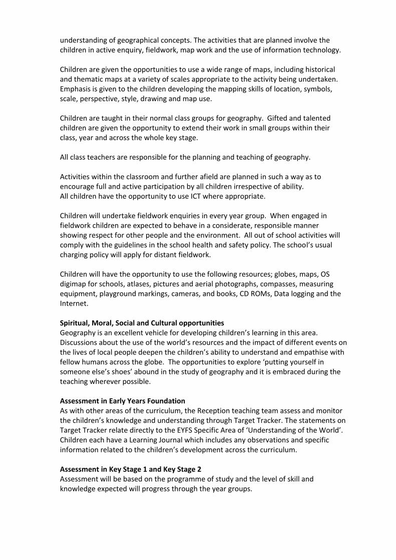
Term 3 World Climates
Identify different climate zones on a world map
Identify key biomes and vegetation belts
Identify longest river in each continent and highest mountain.
Latitude, longitude, tropics Cancer and Capricorn, Arctic and Antarctic,
Identify the distribution of a key natural resource such as oil/wheat/rice
Present findings using maps and GIS
Term 4 Create a country
Use knowledge of Climate, physical and human geography to create an island
Economic activity, trade links distribution of resources, energy, food, minerals, water
Draw a map and guide book for your country – use graphs and maps to present findings
Term 5 Regional study contrasting UK locality and coastlines Isle of Wight
Identify locality on a map of the UK,
Identify the key physical features of the coastline – beach, cliffs, stacks, etc
Identify the key human features – settlements, and economic activities – tourism?
Conduct and enquiry into the importance of the coast to the area, what economic impact would there be as a result of environmental changes to the coastline? E.g. erosion on the south coast – Blackgang chine washed away, A severe pollution event such as an oil spil on the beach – effect on the sands at Alum bay, build up of rubbish etc impact on wildlife.
Use 6 figure references, know how to read an OS map
Undertake fieldwork to observe, measure, record and present findings – e.g. Map of the current pollution/rubbish on the local beach.
Rate 2 different beaches for environmental/tourist appeal
Term 6 History
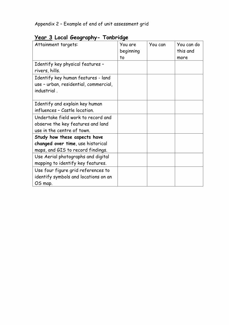
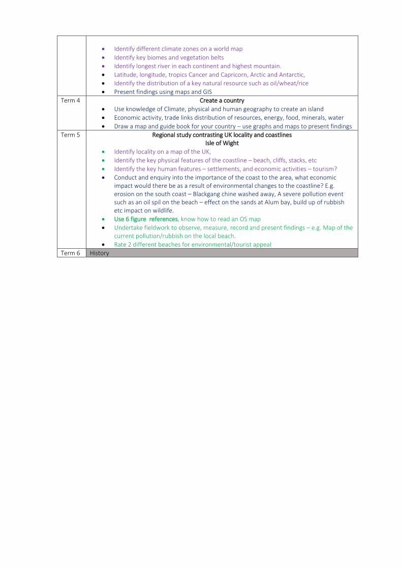
Appendix 2 – Example of end of unit assessment grid
Year 3 Local Geography- Tonbridge Attainment targets: You are
beginning
to
You can You can do
this and
more
Identify key physical features –
rivers, hills.
Identify key human features - land
use – urban, residential, commercial,
industrial .
Identify and explain key human
influences – Castle location.
Undertake field work to record and
observe the key features and land
use in the centre of town.
Study how these aspects have
changed over time, use historical
maps, and GIS to record findings.
Use Aerial photographs and digital
mapping to identify key features.
Use four figure grid references to
identify symbols and locations on an
OS map.