Embed Size (px)
Citation preview

ANNEX 0
PTC 43, 2-6 May 2016
New Delhi, India
LIST OF ANNEXES
ANNEX 1.I List of Participants
ANNEX 1.II Agenda
ANNEX 2.I Follow up action PTC42
ANNEX 4.1.I Summary of Cyclonic Activities over north Indian Ocean during 2015
ANNEX 4.3.I WMO/SAT: Indian Ocean Data Coverage (IODC)
ANNEX 4.3.II WMO/OSD: Observing Systems Division
ANNEX 4.3.III Meteorological, hydrological, DRR, Training and Research
components : Members activities
ANNEX 4.4.I WMO/HWR: Associated Programme on Flood Management and
WMO/HWR: Flash Flood Guidance System
ANNEX 4.5.I WMO/Disaster Risk reduction
ANNEX 5.1.I Tropical cyclone Coordination and Services
ANNEX 5.1.II WMO list of Events 2015-2016
ANNEX 5.1.III List of Members of the Regional bodies
ANNEX 5.1.IV Preliminary recommendations from IBTrACS-2 and IWTSAT-2
ANNEX 6.I Coordinated Technical Plan
ANNEX 6.II Annual Operating Plan
ANNEX 8.I Summary of the activities of PTC Secretariat
ANNEX 8.II Statement of PTC Secretariat Accounts
ANNEX 9.I Statement of Account of the Panel’s Trust Fund
ANNEX 9.II Resources and support for the Panel’s activities
ANNEX 9.III Terms of reference of the Working Groups
ANNEX 9.IV Terms of reference of the PTC Secretariat
ANNEX 9.V REGIONAL IN-MHEWS

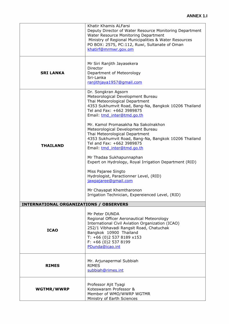
ANNEX 1.I
LIST OF PARTICIPANTS
MEMBERS
PARTICIPANTS
BANGLADESH
Shamsuddin Ahmed
Director
Bangladesh Meteorological Department
INDIA
Dr. L. S Rathore,
Director General of Meteorology, and PR with WMO
India Meteorological Department
Sh. A.K. Sharma,
Scientist-G (Satellite Meteorology)
India Meteorological Department
Dr. M. Mohapatra,
Scientist-G (Services) and Head, RSMC New Delhi
India Meteorological Department
Dr. D. Pradhan,
Scientist-G (Instruments)
India Meteorological Department
Dr. S. K. Roy Bhowmik ,
Sc. F, DDGM(Numerical Weather Prediction)
India Meteorological Department
Sh. S.K. Kundu,
Sc. F (Budget & Planning)
India Meteorological Department
Dr. S. Kaur,
Sc F, DDGM(Hydrology)
India Meteorological Department
Dr. R. Suresh, Sc. F
DDGM (Civil Aviation Meteorological Department)
India Meteorological Department
Dr. S.D. Attri,
Sc. F, DDGM(Organisation)
India Meteorological Department
Sh. S.C. Bhan,
Sc. F, DDGM (Publication)
India Meteorological Department
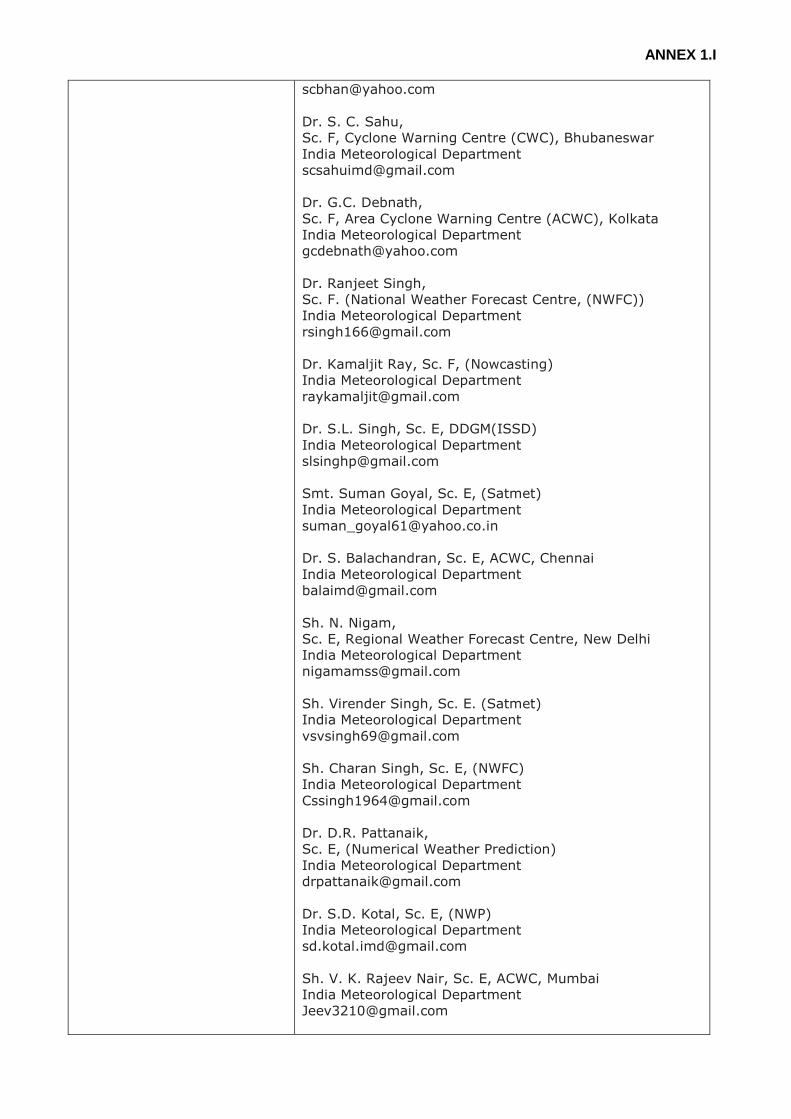
ANNEX 1.I
Dr. S. C. Sahu,
Sc. F, Cyclone Warning Centre (CWC), Bhubaneswar
India Meteorological Department
Dr. G.C. Debnath,
Sc. F, Area Cyclone Warning Centre (ACWC), Kolkata
India Meteorological Department
Dr. Ranjeet Singh,
Sc. F. (National Weather Forecast Centre, (NWFC))
India Meteorological Department
Dr. Kamaljit Ray, Sc. F, (Nowcasting)
India Meteorological Department
Dr. S.L. Singh, Sc. E, DDGM(ISSD)
India Meteorological Department
Smt. Suman Goyal, Sc. E, (Satmet)
India Meteorological Department
Dr. S. Balachandran, Sc. E, ACWC, Chennai
India Meteorological Department
Sh. N. Nigam,
Sc. E, Regional Weather Forecast Centre, New Delhi
India Meteorological Department
Sh. Virender Singh, Sc. E. (Satmet)
India Meteorological Department
Sh. Charan Singh, Sc. E, (NWFC)
India Meteorological Department
Dr. D.R. Pattanaik,
Sc. E, (Numerical Weather Prediction)
India Meteorological Department
Dr. S.D. Kotal, Sc. E, (NWP)
India Meteorological Department
Sh. V. K. Rajeev Nair, Sc. E, ACWC, Mumbai
India Meteorological Department
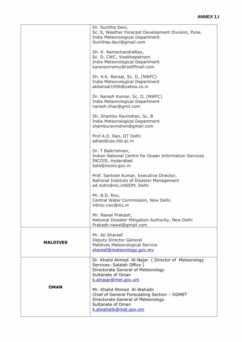
ANNEX 1.I
Dr. Sunitha Devi,
Sc. E, Weather Forecast Development Division, Pune.
India Meteorological Department
Sh. K. RamachandraRao,
Sc. D, CWC, Visakhapatnam
India Meteorological Department
Sh. A.K. Bansal, Sc. D, (NWFC)
India Meteorological Department
Dr. Naresh Kumar, Sc. D, (NWFC)
India Meteorological Department
Sh. Shambu Ravindren, Sc. B
India Meteorological Department
Prof A.D. Rao, IIT Delhi
Dr. T Balkrishnan,
Indian National Centre for Ocean Information Services
INCOIS, Hyderabad
Prof. Santosh Kumar, Executive Director,
National Institute of Disaster Management
[email protected], Delhi
Mr. B.D. Roy,
Central Water Commission, New Delhi
Mr. Nawal Prakash,
National Disaster Mitigation Authority, New Delhi
MALDIVES
Mr. Ali Shareef
Deputy Director General
Maldives Meteorological Service
OMAN
Dr. Khalid Ahmed Al-Najar ( Director of Meteorology
Services- Salalah Office )
Directorate General of Meteorology
Sultanate of Oman
Mr. Khalid Ahmed Al-Wahaibi
Chief of General Forecasting Section – DGMET
Directorate General of Meteorology
Sultanate of Oman
ANNEX 1.I
Khatir Khamis ALFarsi
Deputy Director of Water Resource Monitoring Department
Water Resource Monitoring Department Ministry of Regional Municipalities & Water Resources
PO BOX: 2575, PC:112, Ruwi, Sultanate of Oman
SRI LANKA
Mr Siri Ranjith Jayasekera
Director
Department of Meteorology
Sri-Lanka
THAILAND
Dr. Songkran Agsorn
Meteorological Development Bureau
Thai Meteorological Department
4353 Sukhumvit Road, Bang-Na, Bangkok 10206 Thailand
Tel and Fax: +662 3989875
Email: [email protected]
Mr. Kamol Promasakha Na Sakolnakhon
Meteorological Development Bureau
Thai Meteorological Department
4353 Sukhumvit Road, Bang-Na, Bangkok 10206 Thailand
Tel and Fax: +662 3989875
Email: [email protected]
Mr Thadaa Sukhapunnaphan
Expert on Hydrology, Royal Irrigation Department (RID)
Miss Pajaree Singto
Hydrologist, Paractionner Level, (RID)
Mr Chayapat Khemtharonon
Irrigation Technician, Expereienced Level, (RID)
INTERNATIONAL ORGANIZATIONS / OBSERVERS
ICAO
Mr Peter DUNDA
Regional Officer Aeronautical Meteorology
International Civil Aviation Organization (ICAO)
252/1 Vibhavadi Rangsit Road, Chatuchak
Bangkok 10900 Thailand
T: +66 (0)2 537 8189 x153
F: +66 (0)2 537 8199
RIMES
Mr. Arjunapermal Subbiah
RIMES
WGTMR/WWRP
Professor Ajit Tyagi
Koteswaram Professor &
Member of WMO/WWRP WGTMR
Ministry of Earth Sciences

ANNEX 1.I
174 Sector 28
NOIDA, India
SECRETARIAT
WMO SECRETARIAT
Dr.Xu Tang
Director
Weather and Disaster Risk Reduction Service
Anne-Claire Fontan
Scientific Officer
Tropical Cyclone Programme Division
ECONOMIC AND SOCIAL
COMMISSION FOR ASIA
AND THE PACIFIC
(UN-ESCAP)
Dr Shamika Sirimanne
Director/UN-ESCAP
Information and Communications Technology and Disaster
Risk Reduction Division
Dr. Sanjay K Srivastava
Chief/UN-ESCAP
Disaster Risk Reduction Section of the ICT
Mr. Sung-Eun KIM
Disaster Risk Reduction Section, IDD
United Nations ESCAP
Bangkok 10200, Thailand
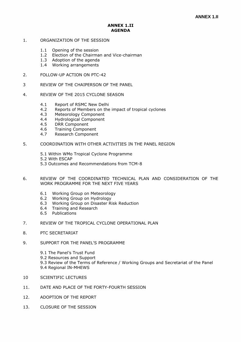
ANNEX 1.II
ANNEX 1.II
AGENDA
1. ORGANIZATION OF THE SESSION
1.1 Opening of the session
1.2 Election of the Chairman and Vice-chairman
1.3 Adoption of the agenda
1.4 Working arrangements
2. FOLLOW-UP ACTION ON PTC-42
3 REVIEW OF THE CHAIPERSON OF THE PANEL
4. REVIEW OF THE 2015 CYCLONE SEASON
4.1 Report of RSMC New Delhi
4.2 Reports of Members on the impact of tropical cyclones
4.3 Meteorology Component
4.4 Hydrological Component
4.5 DRR Component
4.6 Training Component
4.7 Research Component
5. COORDINATION WITH OTHER ACTIVITIES IN THE PANEL REGION
5.1 Within WMo Tropical Cyclone Programme
5.2 With ESCAP
5.3 Outcomes and Recommendations from TCM-8
6. REVIEW OF THE COORDINATED TECHNICAL PLAN AND CONSIDERATION OF THE
WORK PROGRAMME FOR THE NEXT FIVE YEARS
6.1 Working Group on Meteorology
6.2 Working Group on Hydrology
6.3 Working Group on Disaster Risk Reduction
6.4 Training and Research
6.5 Publications
7. REVIEW OF THE TROPICAL CYCLONE OPERATIONAL PLAN
8. PTC SECRETARIAT
9. SUPPORT FOR THE PANEL'S PROGRAMME
9.1 The Panel’s Trust Fund
9.2 Resources and Support
9.3 Review of the Terms of Reference / Working Groups and Secretariat of the Panel
9.4 Regional IN-MHEWS
10 SCIENTIFIC LECTURES
11. DATE AND PLACE OF THE FORTY-FOURTH SESSION
12. ADOPTION OF THE REPORT
13. CLOSURE OF THE SESSION
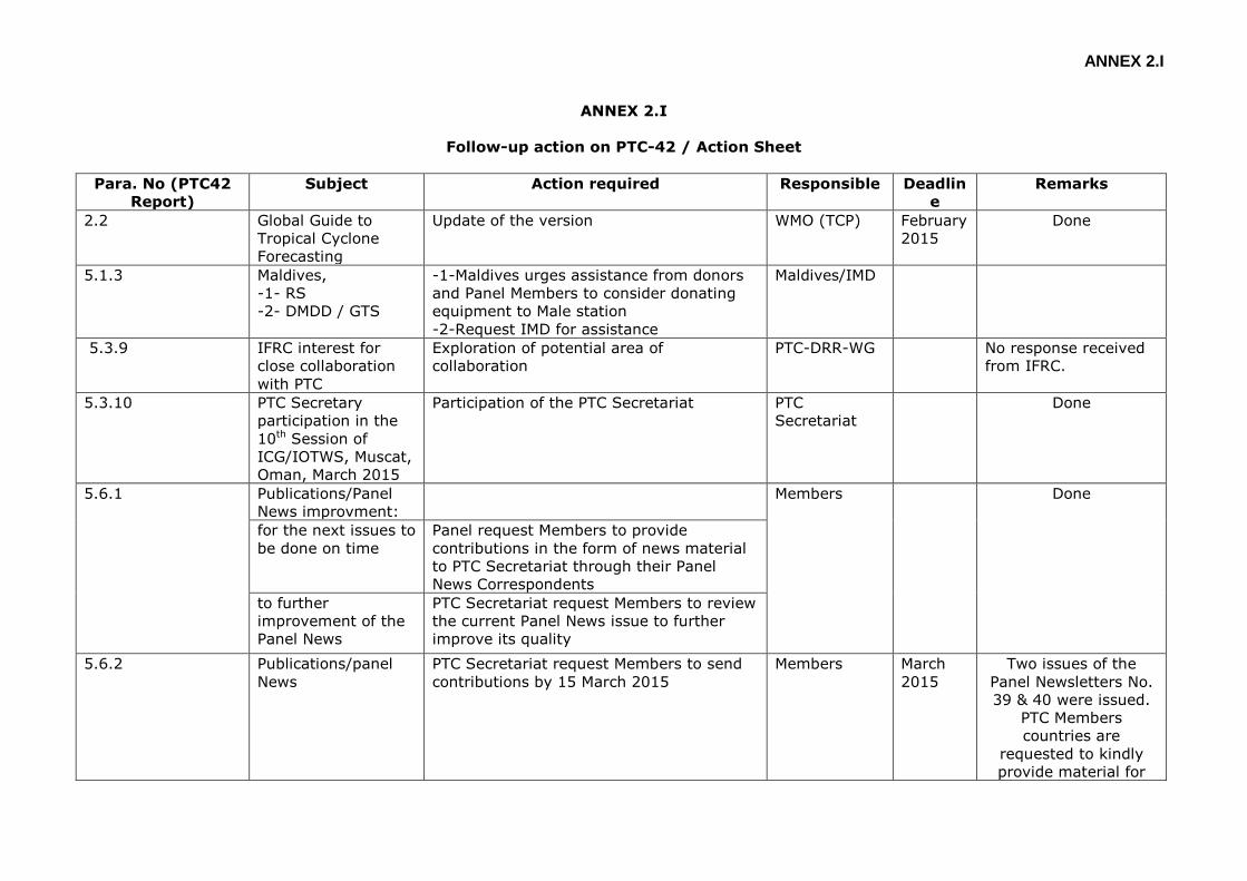
ANNEX 2.I
ANNEX 2.I
Follow-up action on PTC-42 / Action Sheet
Para. No (PTC42
Report)
Subject Action required Responsible Deadlin
e
Remarks
2.2 Global Guide to
Tropical Cyclone
Forecasting
Update of the version WMO (TCP) February
2015
Done
5.1.3 Maldives,
-1- RS
-2- DMDD / GTS
-1-Maldives urges assistance from donors
and Panel Members to consider donating
equipment to Male station
-2-Request IMD for assistance
Maldives/IMD
5.3.9 IFRC interest for
close collaboration
with PTC
Exploration of potential area of
collaboration
PTC-DRR-WG No response received
from IFRC.
5.3.10 PTC Secretary
participation in the
10th Session of
ICG/IOTWS, Muscat,
Oman, March 2015
Participation of the PTC Secretariat PTC
Secretariat
Done
5.6.1 Publications/Panel
News improvment:
Members Done
for the next issues to
be done on time
Panel request Members to provide
contributions in the form of news material
to PTC Secretariat through their Panel
News Correspondents
to further
improvement of the
Panel News
PTC Secretariat request Members to review
the current Panel News issue to further
improve its quality
5.6.2 Publications/panel
News
PTC Secretariat request Members to send
contributions by 15 March 2015
Members March
2015
Two issues of the
Panel Newsletters No.
39 & 40 were issued.
PTC Members
countries are
requested to kindly
provide material for
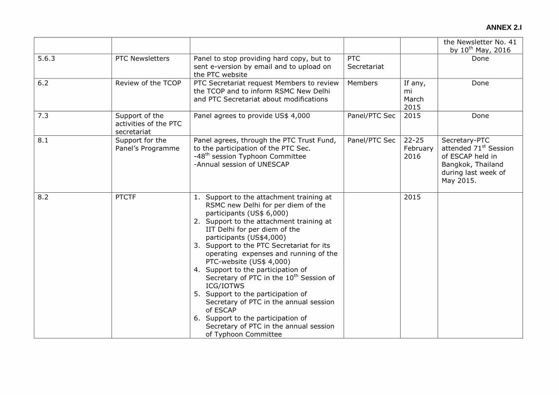
ANNEX 2.I
the Newsletter No. 41
by 10th May, 2016
5.6.3 PTC Newsletters Panel to stop providing hard copy, but to
sent e-version by email and to upload on
the PTC website
PTC
Secretariat
Done
6.2 Review of the TCOP PTC Secretariat request Members to review
the TCOP and to inform RSMC New Delhi
and PTC Secretariat about modifications
Members If any,
mi
March
2015
Done
7.3 Support of the
activities of the PTC
secretariat
Panel agrees to provide US$ 4,000 Panel/PTC Sec 2015 Done
8.1 Support for the
Panel’s Programme
Panel agrees, through the PTC Trust Fund,
to the participation of the PTC Sec.
-48th session Typhoon Committee
-Annual session of UNESCAP
Panel/PTC Sec 22-25
February
2016
Secretary-PTC
attended 71st Session
of ESCAP held in
Bangkok, Thailand
during last week of
May 2015.
8.2 PTCTF 1. Support to the attachment training at
RSMC new Delhi for per diem of the
participants (US$ 6,000)
2. Support to the attachment training at
IIT Delhi for per diem of the
participants (US$4,000)
3. Support to the PTC Secretariat for its
operating expenses and running of the
PTC-website (US$ 4,000)
4. Support to the participation of
Secretary of PTC in the 10th Session of
ICG/IOTWS
5. Support to the participation of
Secretary of PTC in the annual session
of ESCAP
6. Support to the participation of
Secretary of PTC in the annual session
of Typhoon Committee
2015

ANNEX 4.1.I
ANNEX 4.1.I
SUMMARY OF CYCLONIC ACTIVITIES OVER NORTH INDIAN OCEAN DURING 2015
This document is available the following weblink
https://www.wmo.int/pages/prog/www/tcp/reports.html (SeasonReport_Part 1 and 2)
ANNEX 4.4.I
ANNEX 4.3.I
METEOROLOGICAL COMPONENT
WMO ACTIVITY
SPACE PROGRAMME
Indian Ocean Data Coverage (IODC) - CGMS Roadmap
1 INTRODUCTION
At their 43rd session in 2015, the Coordination Group for Meteorological Satellites (CGMS)
approved a roadmap for the future provision of Indian Ocean Data Coverage (satellite
services) once the EUMETSAT Meteosat-7 reaches its end-of-life in March 2017 with the re-
orbiting of the satellite to follow in April/May 2017.
The aim of the roadmap is to provide a resilient multi-partner IODC service in the
region. It includes the EUMETSAT best effort contribution to the overall IODC services,
which includes the proposal to relocate Meteosat-8 at 40° E.
1.1 Background
Indian Ocean Data Coverage (IODC) by EUMETSAT is a best effort undertaking which reflects
a decision of the EUMETSAT Council to use a residual Meteosat First Generation capacity
for this purpose, in the context of a temporary data gap over the Indian Ocean.
Meteosat-7, the last satellite of the Meteosat First Generation, will reach its end-of-life in
March 2017 with the re-orbiting of the satellite to follow in April/May 2017, thereby
ending the agreed best-effort support to IODC by EUMETSAT.
The paper starts by presenting the current IODC services and the agreed requirements for
future IODC services.
Then, the capabilities of the CGMS partner’s satellites and services in the region that may
be available in 2017 and beyond are presented, followed by a detailed assessment of each
system. This detailed assessment considers:
- Image acquisition schedule and scan pattern;
- Instrument performance;
- Image and product data access and redistribution;
- Product formats;
- Data Collection Systems.
The information is based on inputs received during the Intercessional period.
Annex I contains a table with detailed information concerning CGMS Satellites IODC
Image and Products.
2 CURRENT IODC SERVICE AND REQUIREMENTS
2.1 Meteosat-7 IODC Services

ANNEX 4.4.I
Meteosat-7 was launched on 2 September 1997 and has been providing Indian Ocean Data
Coverage (IODC) service at 57.5°E since 5 December 2006. The end-of-life of the spacecraft
is in April 2017 with the re-orbiting in May 2017.
Meteosat-7 provides several services in the region:
Imaging
- Meteosat-7 takes a full Earth disc image in three spectral channels (Visible (VIS),
Infra-Red (IR) and Water Vapour (WV)) every 30 minutes;
- The pixel resolution at the sub-satellite point is: 2.5 km VIS (using both VIS
detectors); 5.0 km IR and WV.
Products
- The main meteorological products generated in Near-Real-Time (NRT) are
Atmospheric Motion Vectors (AMV), Upper-Tropospheric humidity (UTH), Clear-Sky
Radiances (CSR), All-Sky Radiances (ASR), Multisensor Precipitation Estimate (MPE),
Cloud Analysis (CLA) and Cloud Mask (CLM);
- Of these, the AMV and CSR are currently assimilated by several numerical prediction
centres operationally and the quality is monitored on an operational basis by the NWP
SAF and early studies, performed by ECMWF, demonstrated the benefits of this
data for their model;
- In addition, EUMETSAT IODC service supports other international activities like
SCOPE-CM and is also the prime source of geostationary data in this region
supporting also ISCCP (International Satellite Cloud Climatology Project).
Data Collection Systems
- 5 Indian Ocean Tsunami Warning Systems (IOTWS) networks are supported
(Indonesia 12, Maldives 3, Burma 2, Sri Lanka 1 and Philippines 3) – 21 DCPs in
total;
- Hydrology/Met stations - 129 stations: Sri Lanka 122 and Bhutan 5 – 127 DCPs in
total;
- Capability for HRDCPs (1200bps) has been added to the Meteosat-7 system, but no
DCPs allocated yet.
Dissemination
- Images, Products and DCP messages are variously disseminated on EUMETCast to
Europe and Africa and Americas;
- Distribution of data also directly to NOAA;
- DCP bulletins disseminated on the GTS.

ANNEX 4.4.I
2.2 IODC User Requirements
The following user requirements for the IODC services were agreed at CGMS-42:
Imaging
- Coverage: Full Earth
- Bands: (Visible (VIS), Infra-Red (IR) and Water Vapour (WV)
- Resolution: 2.5 km VIS (using both VIS detectors); 5.0 km IR and WV
- Repetition rate: every 30 minutes
Product
- Atmospheric Motion Vectors (AMV)
- Clear-Sky Radiances (CSR)
Image and Product Data Distribution
- NRT Data Distribution of L1.5 images and L2 Products
Image and Product Data Policy
- Complies with WMO Resolution 40 (Cg-XII)
DCS
- Access (Data Policy): Free for environmental use
- Data Rates (Capacity): 100 bps
- Data distribution: NRT via GTS and Internet
3 SATELLITE OPERATORS IN THE INDIAN OCEAN REGION
The following tables list the satellites which are and may be in operations in the Indian
Ocean region (defined by CGMS as 36°E – 108°E) in the timeframe 2014 – 2017 and
beyond.
3.1 Satellites in orbit
Satellite Longitude Operator Launch date Projected EOL
Meteosat-7 57.5°E EUMETSAT 02/09/1997 Q1 2017
Meteosat-8 3.5°E # EUMETSAT 28/08/2002 2020
Elektro-L N1 76°E Roshydromet 20/01/2011 ≥ 2021
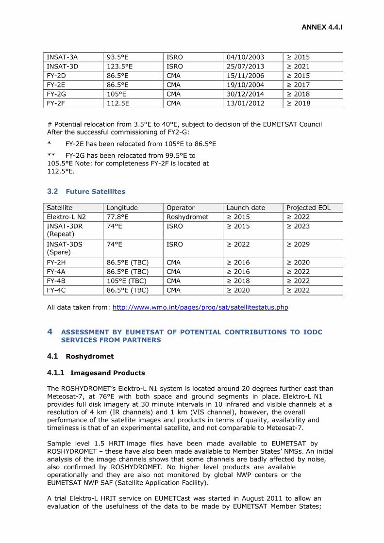
ANNEX 4.4.I
INSAT-3A 93.5°E ISRO 04/10/2003 ≥ 2015
INSAT-3D 123.5°E ISRO 25/07/2013 ≥ 2021
FY-2D 86.5°E CMA 15/11/2006 ≥ 2015
FY-2E 86.5°E CMA 19/10/2004 ≥ 2017
FY-2G 105°E CMA 30/12/2014 ≥ 2018
FY-2F 112.5E CMA 13/01/2012 ≥ 2018
# Potential relocation from 3.5°E to 40°E, subject to decision of the EUMETSAT Council
After the successful commissioning of FY2-G:
* FY-2E has been relocated from 105°E to 86.5°E
** FY-2G has been relocated from 99.5°E to
105.5°E Note: for completeness FY-2F is located at
112.5°E.
3.2 Future Satellites
Satellite Longitude Operator Launch date Projected EOL
Elektro-L N2 77.8°E Roshydromet ≥ 2015 ≥ 2022
INSAT-3DR
(Repeat)
74°E ISRO ≥ 2015 ≥ 2023
INSAT-3DS
(Spare)
74°E ISRO ≥ 2022 ≥ 2029
FY-2H 86.5°E (TBC) CMA ≥ 2016 ≥ 2020
FY-4A 86.5°E (TBC) CMA ≥ 2016 ≥ 2022
FY-4B 105°E (TBC) CMA ≥ 2018 ≥ 2022
FY-4C 86.5°E (TBC) CMA ≥ 2020 ≥ 2022
All data taken from: http://www.wmo.int/pages/prog/sat/satellitestatus.php
4 ASSESSMENT BY EUMETSAT OF POTENTIAL CONTRIBUTIONS TO IODC
SERVICES FROM PARTNERS
4.1 Roshydromet
4.1.1 Imagesand Products
The ROSHYDROMET’s Elektro-L N1 system is located around 20 degrees further east than
Meteosat-7, at 76°E with both space and ground segments in place. Elektro-L N1
provides full disk imagery at 30 minute intervals in 10 infrared and visible channels at a
resolution of 4 km (IR channels) and 1 km (VIS channel), however, the overall
performance of the satellite images and products in terms of quality, availability and
timeliness is that of an experimental satellite, and not comparable to Meteosat-7.
Sample level 1.5 HRIT image files have been made available to EUMETSAT by
ROSHYDROMET – these have also been made available to Member States’ NMSs. An initial
analysis of the image channels shows that some channels are badly affected by noise,
also confirmed by ROSHYDROMET. No higher level products are available
operationally and they are also not monitored by global NWP centers or the
EUMETSAT NWP SAF (Satellite Application Facility).
A trial Elektro-L HRIT service on EUMETCast was started in August 2011 to allow an
evaluation of the usefulness of the data to be made by EUMETSAT Member States;
ANNEX 4.4.I
however at the time of writing, Elektro L-N1 data is only intermittently available due to
an ongoing satellite anomaly.
The second satellite in the Elektro-L series (N2) has been launched on 11 December
2015 and is currently undergoing commissioning. More details at http://www.wmo-
sat.info/oscar/satellites/view/74 .
4.1.2 Data Collection Services
Information concerning the Data Collection Service operated by Roshydromet is
presented in Annex II.
The DCS is fully functional using Elektro-L N1.
Roshydromet is ready to provide WMO members with the international channels for data
transmission from DCPs via Electro-L N1 if required.
Information concerning how to allocate DCPs and how to access DCP data outside Russia
is not yet available. It should be noted that DCP messages are not currently distributed
on the GTS. ROSHYDROMET has indicated its willingness in adding the data on the GTS
should it be required.
4.2 ISRO
4.2.1 Images and Products
INSAT 3D at 82°E was launched in July 2013. Sample images and also sample L1b data
(counts, radiances, temperatures, albedos, SST) have been made available to EUMETSAT
for assessment. The preliminary results are very favourable. The L1B data are well laid out
in HDF and easy to read with good metadata, with full explicit geo- location, the data
size is about 420MB per image cycle. Additionally L1C data are available ~90 MB in
HDF5, with projection details (50N to 50S, 20E to 150E). The SST is also in HDF and covers
the Indian Ocean, the Arabian Gulf, the South China Sea, etc. INSAT-3D AMVs are available
on the GTS.
Off-line AMV passive monitoring at ECMWF was introduced from October 2014, and there
are plans to include this in the operational monitoring. ECMWF state that AMV quality
looks promising. The monitoring statistics are generally in line with what is seen for other
GEO satellites. Some open issues remain, which have been passed to IMD.
There are some issues with the provision of the data that should be solved before
actual use of the data can be considered:
- provide more meaningful quality control information;
- separate cloudy and clear-sky water vapour AMVs;
- use correct computational method in the BUFR file;
- understand why and when a limit of 1000 observations/channel/time is applied.
4.2.2 Data Collection Services
Information concerning the Data Collection Service operated by ISRO is presented in
Annex II.
INSAT 3A currently supports the DCS.
ANNEX 4.4.I
ISRO have agreed to the possible use of the INSAT DCS by WMO members if
required, however it should be noted that the ISRO System does not support 100 bps
DCPs, which transmit via Meteosat-7.
4.3 CMA
4.3.1 Images and Products
The FY-2D and 2E satellites currently provide full disk images every half an hour in five
channels (Vis at 1.24 km all infrared (IR) shortwave IR, water vapour and two split
window at 5 km). These images are received at EUMETSAT and disseminated via
EUMETCast.
For FY-2E located at 105°E, coverage of the Indian Ocean region is not comparable to that
provided by Meteosat-7 and not focused on the same area of interest. FY-2D at 86.5°E
provides better coverage of the Indian Ocean region but is 30 degrees to the east of
Meteosat-7. The flow of FY2-D and FY2-E image data and products to EUMETSAT is reliable
and is simple in terms of configuration leading to a service of high availability.
The FY-2D imagery has been reported to have significant straylight problems affecting the
FY-2D image and product quality. This was confirmed at bilateral meetings with CMA,
where CMA also stated that the water-vapour channel spectral response function was not well
characterized pre-launch. Therefore, it is not possible to generate clear-sky radiance products
from this satellite. The water-vapour channel issues, combined with the straylight effects
have rendered the FY-2D AMVs unusable for global NWP data assimilation.
These observations are in line with the results of the EUMETSAT NWP SAF and global NWP
centres satellite-derived wind-speed and radiance product monitoring. This site shows the
results of product comparisons routinely generated for any satellite operator that makes the
products available to the global community.
The following URL provides a link to the NWP SAF AMV monitoring as well as to the
monitoring provided by some other NWP centres:
http://research.metoffice.gov.uk/research/interproj/nwpsaf/monitoring.html
CMA is planning to replace FY-2D with FY-2E, following the successful launch and
commissioning of FY2-G in 2015.
4.3.2 Data Collection Services
Information concerning the Data Collection Service operated by CMA is presented in Annex
II.
CMA operates the DCS on FY-2E at 105°. CMA also confirmed that the international
channels can be used by international users if required. The DCS would need to be
operated via the satellite at 86.5°E if it were to be a replacement for the current
Meteosat-7 service. Additionally further information is required concerning the allocation
process and the DCP data distribution mechanisms.
ANNEX 4.4.I
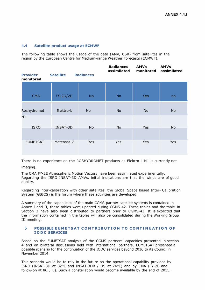
4.4 Satellite product usage at ECMWF
The following table shows the usage of the data (AMV, CSR) from satellites in the
region by the European Centre for Medium-range Weather Forecasts (ECMWF).
Provider Satellite Radiances
monitored
Radiances
assimilated
AMVs
monitored
AMVs
assimilated
CMA FY-2D/2E No No Yes no
Roshydromet Elektro-L
N1
No No No No
ISRO INSAT-3D No No Yes No
EUMETSAT Meteosat-7 Yes Yes Yes Yes
There is no experience on the ROSHYDROMET products as Elektro-L N1 is currently not
imaging.
The CMA FY-2E Atmospheric Motion Vectors have been assimilated experimentally.
Regarding the ISRO INSAT-3D AMVs, initial indications are that the winds are of good
quality.
Regarding inter-calibration with other satellites, the Global Space based Inter- Calibration
System (GSICS) is the forum where these activities are developed.
A summary of the capabilities of the main CGMS partner satellite systems is contained in
Annex I and II, these tables were updated during CGMS-42. These tables and the table in
Section 3 have also been distributed to partners prior to CGMS-43. It is expected that
the information contained in the tables will also be consolidated during the Working Group
III meeting.
5 POSSIBLE E UMET S AT C O N T R I B U T I O N T O C O N T I N U A T I O N O F
I O D C SERVICES
Based on the EUMETSAT analysis of the CGMS partners’ capacities presented in section
4 and on bilateral discussions held with international partners, EUMETSAT presented a
possible scenario for the continuation of the IODC services beyond 2016 to its Council in
November 2014.
This scenario would be to rely in the future on the operational capability provided by
ISRO (INSAT-3D at 82°E and INSAT-3DR / DS at 74°E) and by CMA (FY-2E and
follow-on at 86.5°E). Such a constellation would become available by the end of 2015,
ANNEX 4.4.I
once FY-2E has been repositioned at 86.5°E. Once Elektro-L N2 is launched and
successfully commissioned, this could also be added to the overall constellation.
In addition, in the 2016 timeframe, Meteosat-8 might be repositioned around 40°E, to
support the acquisition of images in the Western part of the Indian Ocean. This
intermediate position would overlap with other satellites, maximising opportunities of
cross-calibration, and increasing the robustness/resilience of the IODC mission thanks to
international cooperation.
Should Meteosat-8 be relocated to 40°E, then the DCS, currently using Meteosat-7
could easily be moved to Meteosat-8.
The EUMETSAT Council agreed that EUMETSAT further study the relocation of Meteosat-8
to 40°E, with the understanding t h a t the remaining Meteosat satellites are capable of
supporting the EUMETSAT Baseline operational services. In the nominal MSG-4
schedule, such a decision by the EUMETSAT Council can be expected in June 2016.
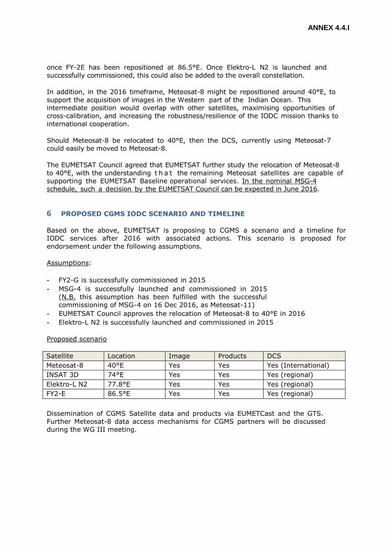
6 PROPOSED CGMS IODC SCENARIO AND TIMELINE
Based on the above, EUMETSAT is proposing to CGMS a scenario and a timeline for
IODC services after 2016 with associated actions. This scenario is proposed for
endorsement under the following assumptions.
Assumptions:
- FY2-G is successfully commissioned in 2015
- MSG-4 is successfully launched and commissioned in 2015
(N.B. this assumption has been fulfilled with the successful
commissioning of MSG-4 on 16 Dec 2016, as Meteosat-11)
- EUMETSAT Council approves the relocation of Meteosat-8 to 40°E in 2016
- Elektro-L N2 is successfully launched and commissioned in 2015
Proposed scenario
Satellite Location Image Products DCS
Meteosat-8 40°E Yes Yes Yes (International)
INSAT 3D 74°E Yes Yes Yes (regional)
Elektro-L N2 77.8°E Yes Yes Yes (regional)
FY2-E 86.5°E Yes Yes Yes (regional)
Dissemination of CGMS Satellite data and products via EUMETCast and the GTS.
Further Meteosat-8 data access mechanisms for CGMS partners will be discussed
during the WG III meeting.

ANNEX 4.3.I
Proposed timeline
2015
- EUMETSAT to disseminate INSAT-3D images and products via EUMETCast
- CMA to relocate FY2-E to 86.5°E and commence an operational service
- EUMETSAT to disseminate FY2-E images and products from 86.5°E via
EUMETCast
2016
- EUMETSAT relocate Meteosat-8 to 40°E
- EUMETSAT commence a Meteosat-8 operational service including images and
products via EUMETCast
- Roshydromet commence an Elektro-L N2 operational service
- EUMETSAT to disseminate Elektro-L N2 images and products via EUMETCast
ANNEX 4.3.II
ANNEX 4.3.II
METEOROLOGICAL COMPONENT
WMO ACTIVITIES
OBSERVING SYSTEM
OBSERVATING SYSTEMS
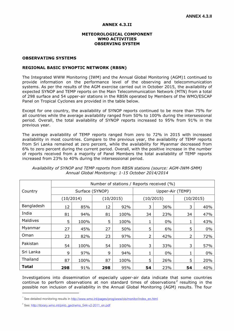
REGIONAL BASIC SYNOPTIC NETWORK (RBSN)
The Integrated WWW Monitoring (IWM) and the Annual Global Monitoring (AGM)1 continued to
provide information on the performance level of the observing and telecommunication
systems. As per the results of the AGM exercise carried out in October 2015, the availability of
expected SYNOP and TEMP reports on the Main Telecommunication Network (MTN) from a total
of 298 surface and 54 upper-air stations in the RBSN operated by Members of the WMO/ESCAP
Panel on Tropical Cyclones are provided in the table below.
Except for one country, the availability of SYNOP reports continued to be more than 75% for
all countries while the average availability ranged from 50% to 100% during the intersessional
period. Overall, the total availability of SYNOP reports increased to 95% from 91% in the
previous year.
The average availability of TEMP reports ranged from zero to 72% in 2015 with increased
availability in most countries. Compare to the previous year, the availability of TEMP reports
from Sri Lanka remained at zero percent, while the availability for Myanmar decreased from
6% to zero percent during the current period. Overall, with the positive increase in the number
of reports received from a majority of Panel Members the total availability of TEMP reports
increased from 23% to 40% during the intersessional period.
Availability of SYNOP and TEMP reports from RBSN stations (source: AGM-IWM-SMM)
Annual Global Monitoring: 1-15 October 2014/2014
Country
Number of stations / Reports received (%)
Surface (SYNOP) Upper-Air (TEMP)
(10/2014) (10/2015) (10/2015) (10/2015)
Bangladesh 12 85% 12 92% 3 36% 3 40%
India 81 94% 81 100% 34 23% 34 47%
Maldives 5 100% 5 100% 1 0% 1 43%
Myanmar 27 45% 27 50% 5 6% 5 0%
Oman 23 82% 23 97% 2 42% 2 72%
Pakistan 54 100% 54 100% 3 33% 3 57%
Sri Lanka 9 97% 9 94% 1 0% 1 0%
Thailand 87 100% 87 100% 5 26% 5 20%
Total 298 91% 298 95% 54 23% 54 40%
Investigations into dissemination of especially upper-air data indicate that some countries
continue to perform observations at non standard times of observations 2 resulting in the
possible non inclusion of availability in the Annual Global Monitoring (AGM) results. The four
1 See detailed monitoring results in http://www.wmo.int/pages/prog/www/ois/monitor/index_en.html 2 See: http://library.wmo.int/pmb_ged/wmo_544-v2-2011_en.pdf
ANNEX 4.4.I
main standard times of observations for surface synoptic stations are 00, 06, 12 and 18 UTC
and for upper-air synoptic stations carrying out radiosonde and radiowind observations it is 00
and 12 UTC.
MARINE AND OCEAN METEOROLOGICAL OBSERVATIONS
The Observations Programme Area (OPA) of the Joint WMO-IC Technical Commission
for Oceanography and Marine Meteorology (JCOMM), in 2015 developed a five year work plan
(2015-2020), taking into considerations of observational requirements, observing systems
performance monitoring, risk assessment etc. The observing system is proposed to meet both
climate requirements, and the requirements of non-climate applications, including NWP,
tropical cyclone prediction, global and coastal ocean prediction, and ocean forecasting and
marine services in general. Detailed requirements are documented in the Implementation Plan
of the Global Climate Observing System update (GCOS No.1843).
In the past years, there has been some progress in the marine observing networks at
global and regional levels. The observing system met 66% its global implementation targets by
December 2015, a slight increase from last reporting period. All data are made freely available
to all Members in real time. There are several observing networks that fully meet their
implementation goals, such as surface measurements from Voluntary Ships (VOS), global
drifting surface buoys, Argo profiling floats 100% completion4. The progress results from
investment and efforts from Members/Member States, including in the WMO Regional
Association II (RA-II), while sustainable investment is still needed to maintain and implement
the observing systems target.
The global surface buoy network coordinated through the Data Buoy Cooperation Panel
(DBCP) has now been sustained and stable (historical target of 1,250 drifters operational). The
Implementation Plan of the Global Climate Observing System (2010) required to increase
number of drifters carrying pressure sensors, and 57% operational drifters currently available
for sea level pressure. The Seventeenth Session of WMO Congress (Cg-17, May-June, 2015,
Geneva, Switzerland) urged Members to follow DBCP recommendations on vandalism
prevention. Cg-17 also invited all Members to commit appropriate resources to the barometer
drifters, and the tropical moored buoy arrays, with a view to support Members improving NWP.
New technologies such as surface gliders also have the potential for contributing useful data to
typhoon prediction.
A series of training workshop have been organized by DBCP for the North Pacific Ocean
and its Marginal Seas (NPOMS). These workshops focus on the application of regional ocean
observations for increasing society's understanding and forecasting of typhoons in the NPOMS
region. Based on lessons and experience obtained over the past 4 NPOMS workshop, Members
are encouraged to comply with existing data policies of WMO and IOC, and to share data real
time via GTS. Members are also encouraged to engage and use the WMO Rolling Review of
Requirements, and consider the requirements for ocean observations in support of Typhoon
prediction. NPOMS-4 (Rep. of Korea, November 2015) raised the question of the importance of
stratification in the NPOMS region to TC development. NPOMS-4 agreed that to answer this
question, more strategic observations are required, to include upper ocean heat content.
Observations can also help assessing the impact of warm and cold eddies on intensification of
typhoons. Impact of data should be assessed e.g. through Observing Systems Experiments
(OSEs), hindcast sensitivity studies, and efforts made to assimilate more of existing impactful
data. In the meantime, Members are encouraged to engage with the Commission for Basic
Systems (CBS), the Tropical Cyclone Programme, and the JCOMM Expert Team on Operational
Ocean Forecasting System (ETOOFS) to take informed and coordinated actions on typhoon
observations and forecasting.
3 http://www.wmo.int/pages/prog/gcos/Publications/gcos-184_I.pdf 4 http://www.osmc.noaa.gov/images/JCOMM_cartoon.pdf

ANNEX 4.4.I
As reported before, Argo profiling float programme reached completion in November
2007, and about 90% of Argo profiles are distributed electronically within 24 hours of
acquisition, efforts to reduce delays in the Global Data Acquisition Centres (GDACs) data
distribution are increasing their timeliness. In 2015, about 800 floats were deployed, with
several deep Argo floats tested, and a growing number of Bio-Argo floats. This added up to
3846 floats operational in mid-April 2016. Argo floats are continuously providing essential
upper ocean thermal and salinity data for Tropical Cyclones research, monitoring and forecast
activities. This also makes it possible to map detailed structure of global ocean temperature
and salinity fields at both surface and subsurface levels. However, with the current deployment
rate, it has been demonstrated (see study5, Durack et al., 2016) that the level of reporting
profiles could not be sustainable in the long term, and the Argo array would decline over the
next decade to about 2400 floats.
The Global Sea Level Observing System (GLOSS) continues to provide tide gauge data
for understanding the recent history of global sea level rise and for studies of interannual to
multi-decadal variability. In the meantime, tide gauges are now playing a greater role in
regional tsunami warning systems and for operational storm surge monitoring. Over 88% of
the GLOSS Core Network (GCN) of about 290 stations can be considered operational. GLOSS
now plans to expand high quality core network beyond initial slate of stations to meet higher
level of standards.
In addition, JCOMM Observations Programme Area (OPA) also coordinates the Ship
Observations Team6 (SOT), including the Voluntary Observing Ship scheme (VOS, for the
making of marine meteorological observations), the Ship of Opportunity Programme (SOOP,
for the making of oceanographic observations, including upper ocean thermal profiles), and the
Automated Ship Board Aerological Programme (ASAP, for the making of upper air
observations). The SOOP programme is providing useful upper ocean thermal profile data in
complement of similar data from the Argo profiling float programme, and the Global Tropical
Moored Buoy Array. Such data are essential for providing estimates of heat content fluxes
between the ocean and the atmosphere in support of typhoon prediction.
The Panel is invited to consider sustained and enhanced contributions of WMO Members
in the region in support of the implementation of the ocean observing systems, including buoy,
Argo, and ship-based networks in the tropical oceans and the provision of ship time to assist in
the deployment and servicing of tropical moored buoys, and for the deployment of drifters and
XBTs. Members interested to contribute are invited to contact the Technical Coordinator of the
Data Buoy Cooperation Panel (DBCP), Ms Champika Gallage ([email protected] and
AIRCRAFT-BASED OBSERVATIONS
The WMO Aircraft Based Observing System, comprising the Aircraft Meteorological Data
Relay (AMDAR) observing system7 supplemented by aircraft based observations (ABO) derived
from ICAO systems, now produces around 700,000 upper air observations per day on the
WMO GTS, with the AMDAR system contributing the vast majority from 40 participating airlines
and a global fleet of over 4000 aircraft. This important sub-system of the WMO Integrated
Global Observing System produces both en-route and vertical profile (from AMDAR aircraft at
airport locations) high quality, upper air data, that continues to demonstrate a significant
positive impact8 on global, regional and high resolution NWP and other forecasting and
meteorological applications.
While the WMO AMDAR programme has continued to grow, as demonstrated in Figure 1
below, there has been no growth in the programme in recent years in WMO Region II and V
5 http://www.nature.com/nclimate/journal/v6/n3/full/nclimate2946.html?WT.feed_name=subjects_hydrology 6 http://www.wmo.int/pages/prog/amp/mmop/sot.html 7 http://www.wmo.int/pages/prog/www/GOS/ABO/AMDAR/index_en.html 8 See : http://www.wmo.int/pages/prog/www/GOS/ABO/data/ABO_Benefits.html
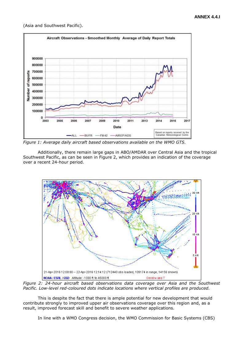
ANNEX 4.4.I
(Asia and Southwest Pacific).
Figure 1: Average daily aircraft based observations available on the WMO GTS.
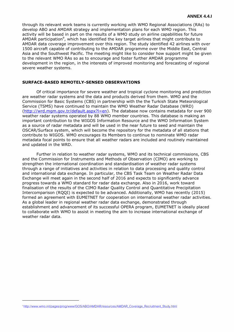
Additionally, there remain large gaps in ABO/AMDAR over Central Asia and the tropical
Southwest Pacific, as can be seen in Figure 2, which provides an indication of the coverage
over a recent 24-hour period.
Figure 2: 24-hour aircraft based observations data coverage over Asia and the Southwest
Pacific. Low-level red-coloured dots indicate locations where vertical profiles are produced.
This is despite the fact that there is ample potential for new development that would
contribute strongly to improved upper air observations coverage over this region and, as a
result, improved forecast skill and benefit to severe weather applications.
In line with a WMO Congress decision, the WMO Commission for Basic Systems (CBS)
ANNEX 4.4.I
through its relevant work teams is currently working with WMO Regional Associations (RAs) to
develop ABO and AMDAR strategy and implementation plans for each WMO region. This
activity will be based in part on the results of a WMO study on airline capabilities for future
AMDAR participation9, which has identified the key target airlines that might contribute to
AMDAR data coverage improvement over this region. The study identified 42 airlines with over
1500 aircraft capable of contributing to the AMDAR programme over the Middle East, Central
Asia and the Southwest Pacific. The meeting might like to consider how support might be given
to the relevant WMO RAs so as to encourage and foster further AMDAR programme
development in the region, in the interests of improved monitoring and forecasting of regional
severe weather systems.
SURFACE-BASED REMOTELY-SENSED OBSERVATIONS
Of critical importance for severe weather and tropical cyclone monitoring and prediction
are weather radar systems and the data and products derived from them. WMO and the
Commission for Basic Systems (CBS) in partnership with the the Turkish State Meteorological
Service (TSMS) have continued to maintain the WMO Weather Radar Database (WRD)
(http://wrd.mgm.gov.tr/default.aspx?l=en). The database now contains metadata for over 900
weather radar systems operated by 88 WMO member countries. This database is making an
important contribution to the WIGOS Information Resource and the WMO Information System
as a source of radar metadata and will be used in the near future to seed and maintain the
OSCAR/Surface system, which will become the repository for the metadata of all stations that
contribute to WIGOS. WMO encourages its Members to continue to nominate WMO radar
metadata focal points to ensure that all weather radars are included and routinely maintained
and updated in the WRD.
Further in relation to weather radar systems, WMO and its technical commissions, CBS
and the Commission for Instruments and Methods of Observation (CIMO) are working to
strengthen the international coordination and standardisation of weather radar systems
through a range of initiatives and activities in relation to data processing and quality control
and international data exchange. In particular, the CBS Task Team on Weather Radar Data
Exchange will meet again in the second half of 2016 and expects to significantly advance
progress towards a WMO standard for radar data exchange. Also in 2016, work toward
finalisation of the results of the CIMO Radar Quality Control and Quantitative Precipitation
Intercomparison (RQQI) is expected to be advanced. Additionally, WMO has recently (2015)
formed an agreement with EUMETNET for cooperation on international weather radar activities.
As a global leader in regional weather radar data exchange, demonstrated through
establishment and advancement of its successful OPERA program, EUMETNET is ideally placed
to collaborate with WMO to assist in meeting the aim to increase international exchange of
weather radar data.
9 http://www.wmo.int/pages/prog/www/GOS/ABO/AMDAR/resources/AMDAR_Coverage_Recruitment_Study.html

ANNEX 4.3.III
ANNEX 4.3.III
ACTIVITIES of the MEMBERS
METEOROLOGICAL COMPONENT
HYDROLOGICAL COMPONENT
DRR COMPONENT
TRAINING COMPONENT
RESEARCH COMPONENT
Those documents can be downloaded at the following link:
https://www.wmo.int/pages/prog/www/tcp/PTC-43_DocPlan.html
ANNEX 4.4.I
ANNEX 4.4.I
HYDROLOGICAL COMPONENT
WMO ACTIVITIES
APFM Information Note
The Associated Programme on Flood Management (APFM) is a joint initiative of WMO
and the Global Water Partnership (GWP). Its objective is to promoting the concept of
Integrated Flood Management (IFM), minimizing loss of life due to flooding and optimizing the
net benefits derived from floodplains. As such, it proposes a paradigm shift from flood
protection to flood management, in line with the Sendai Framework for Disaster Risk
Reduction, where the emphasis has shifted to include not only protection from hazards, but
also the concept of “building back better”.
Since its inception in 2001, the Associated Programme on Flood Management has had several
achievements, namely:
advancing the concept of Integrated Flood Management (IFM) through a concept paper
(currently in its third edition) and a policy paper series focusing on the institutional,
legal, social, economic and environmental aspects of IFM;
developed 25 tools on specific topics related to IFM, providing guidance and know-how
to flood management practitioners willing to adopt an integrated approach to flood
management, comprising both structural and non-structural measures;
disseminated the concept and core aspects of IFM in more than 130 countries, within
more than 450 institutions around the world, and through its website reaching more
than 330,000 views since 2007, and disseminating information of IFM and APFM
activities at an average of 6 international conferences or meetings each year;
provided capacity-building in IFM throughout the world through more than 40
workshops in 27 countries, training more than 1000 participants;
implemented (or is currently implementing) pilot projects on IFM in 18 countries in
Asia, Africa, Europe, and South and Central America, covering community-based flood
management, transboundary flood management, development of national strategies for
flood management, and flood forecasting and early warning systems.
WMO Congress during its Fifteenth Session “appreciated the activities under the
Associated Programme on Flood Management, which had helped achieve the objective of
disaster risk reduction and provided technical support to countries in flood management policy
formulation. It welcomed the establishment of the Help Desk services as a tool for providing
support on flood management policy issues in collaboration with other partners.” Through
Resolution 20 (Cg-XV), Congress decided “That WMO should continue its advocacy for a
widespread adoption of an Integrated Flood Management approach at the basin, national and
international levels”.
Moreover, under Resolution 4 (CHy-XIII), the Commission for Hydrology decided “To
assist setting up of a HelpDesk for Integrated Flood Management for the benefit of Members in
the areas of flood management policy and strategy, and capacity building in support thereof.”
The IFM Help Desk is hosted in WMO but depends on a strong decentralized network of
experts and specialized institutes, called “Support Base Partners” (SBPs), providing input on
advice and advocacy for flood management policy and strategy formulation; technical advice
on the (inter-) national, regional and local level; facilitation of workshops and trainings
supporting the Integrated approach of Flood Management; development and provision of flood
management tools and capacity building material; and formulation of objectives and scoping
for flood management proposals. Currently the network includes 26 partner institutions,
comprising of NHMSs, private sector companies, Universities, other International Organizations
and NGOs.

ANNEX 4.4.I
Since its inception in 2009, the IFM HelpDesk has successfully responded to more than
170 requests from over 40 countries, focusing on capacity building and technical guidance on
flood management issues.
The success of APFM has inspired the development of the Integrated Drought
Management Programme (IDMP), which focuses, with a similar approach, on drought-affected
regions and deals with drought-related issues in an integrated way. Both APFM and IDMP are
part of the GFCS User Interface Platform.
The APFM is funded through extra-budgetary contributions (currently from the
Government of Switzerland, Mexico, France and USAID/OFDA; in the past from the
Governments of Japan, the Netherlands, Italy and Germany).
The APFM is governed through Advisory and Management Committees (AC/MC),
meeting on a yearly basis to review the progress of the last year and to formulate a work-plan
for the incoming year.
At its last meeting in September 2015, noting that the APFM is already presented on
GFCS website as a GFCS project, the AC/MC suggested that the HelpDesk be broadened for
the climate and water communities using the GFCS platform to address climate service needs
in the implementation of Integrated Water Resources Management in the context of climate
variability and change. This would help strengthen existing capacities on flood management
using climate services.
Moreover, the integrated approach promoted by APFM, focusing on prevention and
reduction of existing disaster risk, has been also identified by AC/MC as a strong entry point to
the Sendai Framework for Disaster Risk Reduction. The Sendai Framework aims to reduce
substantially disaster risk and losses in lives, livelihoods and health and in the economic,
physical, social, cultural and environmental assets of persons, businesses, communities and
countries. Its goal is to prevent new - and reduce existing - disaster risk through the
implementation of integrated measures inclusive of economic, structural, legal, social, health,
cultural, educational, environmental, technological, political and institutional.
APFM has been since its inception focusing on this multi-disciplinary approach, and
would be able to assist in the four Priorities of the Sendai Framework (Understanding disaster
risk; Strengthening disaster risk governance to manage disaster risk; Investing in disaster risk
reduction for resilience; and Enhancing disaster preparedness for effective response and to
“Build Back Better” in recovery, rehabilitation and reconstruction; enhancing the role of
stakeholders, international cooperation and global partnerships) highlighting its focus on taking
preventative measures to reduce exposure to risk prior to the onset of event and in
preparedness for response and recovery, activities thereby strengthening societal resilience.
To complement this multi-disciplinary approach, the WMO Flood Forecasting Initiative
Advisory Group (FFI-AG), which was created by Resolution 15 (Cg-XVI), met 1-3 December
2015 and requested that the APFM Technical Support Unit (TSU) undertake an inventory of the
existing guidance material and/or training material and/or expertise through its Support Base
already available through the IFM HelpDesk on flood forecasting and warnings. It also
requested the APFM TSU to design an appropriate interface to offer assistance (in line with the
existing “Get Help” and “Help Yourself” options) in the field of flood forecasting and warnings
and solicit feedback from selected FFI-AG members. This activity is seen as an important step
allowing the WMO/GWP Associated Programme on Flood Management to offer increased
assistance through its HelpDesk for Members wishing to strengthen their End-to-End Early
Warning Systems (E2E EWS) for flood forecasting.
APFM has implemented various pilot project and training workshops in the region:
Thailand

ANNEX 4.4.I
Following a workshop on “Development of National Strategy for Integrated Flood
Management (IFM) for Thailand” held in 2012 by APFM upon request of the Thai Meteorological
Department (TMD), supporting the establishment and operation of a Single Command Centre
for flood management operations within existing governmental structures, a newly developed
strategy for flood management was presented at the ministerial level. This resulted in
reallocation of roles and responsibilities in flood management at the national level.
Moreover, from 2013 to March 2016 a pilot project on “Empowering Communities -
Community-based Approaches to Flood Management in Thailand and Lao PDR” was
implemented by APFM with the Asian Disaster Preparedness Centre (ADPC) in two target
communities in Thailand. Flood management committees were established to develop
community flood management plans to be tested during simulation exercises. Preliminary to
that phase, participatory flood Risk Assessments (PRA) were conducted through the Hazard,
Vulnerability and Capacity Assessment tools involving community leaders and members,
including women, elderly, children, and Community Civil Defense Volunteers, as well as
officials from provincial and district governments. The positive feedback on the methodology
adopted has made local authorities mobilize additional budgetary resources for capacity
building on community based disaster risk reduction for nine other communities in their
administrative areas, requesting the project team to support these initiatives.
Coastal Flood Management in Bangladesh
The Bangladesh Water Partnership requested APFM for support through the Integrated
Flood Management (IFM) HelpDesk. The support had the following objectives: to introduce IFM
concepts and tools to the top management of relevant agencies and stakeholders; to analyse
the current flood management practices in the coastal zone and develop consensus on what
constitutes an integrated approach to flood management in the coastal zone; to obtain
feedback from stakeholders on the current coastal flood management policy and practice; and
to develop a first draft of an Integrated Flood Management framework for the coastal areas of
Bangladesh.
A two-day workshop was held in April 2015 with over 100 participants, including the
Minister of Water Resources, Directors from the government agencies dealing with water,
national and international civil society organizations, academia and potential financial partners.
The presentations and discussion in the workshop elucidated the main flood related issues in
the coastal areas, namely:
- flood management decisions are frequently taken independently from land and water
management, ecosystems and infrastructure;
- women are excluded from decision making processes at the local level;
- embankment heights are not adequate for rising sea level and storm surges, which is a
particularly urgent need considering siltation of river beds;
- technical solutions with narrow scopes are implemented without considering
maintenance of infrastructure;
- foreshore afforestation to reduce impact of storm surges has been limited;
- limited stakeholder involvement in the design and implementation of revamping
infrastructure;
- limited current forecasting ability of coastal flooding (tidal flood and storm surge), only
cyclone forecast and tidal height, no combined flood height forecast in the coastal zone
– a consequence of limited coordination between meteorological and hydrological
services;
- drainage of polders is often problematic, causing water logging, leading to breaking of
embankments by communities; and
- cyclone shelters are available for people, but their assets remain unprotected.
The APFM also provides technical backstopping to the development of a national
strategy, liaising also with the joint CHy/JCOMM initiative Coastal Inundation Forecasting
Demonstration Project (CIFDP).

ANNEX 4.4.I
Flash Flood Guidance System (FFGS) Information Note
Resolution 21 (Cg XV) was adopted to enhance cooperation between national
meteorological and hydrological services for improved flood forecasting and to support the
implementation of demonstration projects such as the Flash Flood Guidance System (FFGS)
with global coverage. A Memorandum of Understanding (MoU) was concluded in 2009 for
establishing a cooperative initiative among the World Meteorological Organization, the
Hydrologic Research Center, the National Weather Service of the U.S. National Oceanic and
Atmospheric Administration, and the U.S Agency for the International Development Office for
U.S. Foreign Disaster Assistance for the Flash Guidance System (FFG) with global coverage
project. The goal of the initiative is to disseminate and implement technologies that provide
early warnings for flash floods, especially in developing countries where no such flash flood
early warning capability exists.
Within the framework of the MoU, the Southern Africa Region Flash Flood Guidance
(SARFFG), Mekong River Commission FFG, (MRCFFG) and Black Sea and Middle East
(BSMEFFG) have been implemented, while, a series of projects are under implementation,
including South East Europe FFG (SEEFFG), Central Asia Region FFG (CARFFG), South Asia FFG
(SAsiaFFG) and Southeastern Asia-Oceania FFG (SAOFFG).
The MRCFFG includes Cambodia, Lao PDR, Thailand and Cambodia. The MRC is the
Regional Centre for the project. Training for the MRCFFG last took place in June 2015 in Phnom
Penh, Cambodia, and included the participation of Myanmar forecasters. Efforts have been
underway to seek MRC concurrence to have Myanmar participate in the MRCFFG project.
The SAsiaFFG includes Afghanistan, Bangladesh, Bhutan, India, Nepal, Pakistan, and Sri
Lanka. The planning workshop for the project was held in Kathmandu, Nepal, from 26 to 28
November 2012. The first Project Steering Committee meeting is to be held in New Delhi,
India, from 26 to 28 April 2016. The planning workshop had proposed two regional centres for
the project, one in Pakistan and one in India. It is anticipated that the upcoming meeting will
attain agreement on a path forward for implementation of the project.
The major activities that have been conducted over the last year include: the CARFFG
initial planning meeting, which was held in May 2015 in Ankara, Turkey, and its first Steering
Committee Meeting, which was held in September 2015 in Astana, Kazakhstan. CARFFG of
operational training of forecasters took place in February 2016 in San Diego, USA with the
participation of two experts from each Central Asia NMHS except Turkmenistan. Two
forecasters from the BSMEFFG (Lebanon) also participated in the operational training.
Development of the FFGS modelling effort for the SEEFFG project was completed and
will soon be installed on the servers in Turkey, the Regional Centre for the project. Operational
training was provided to the forecasters of the participating countries in San Diego, USA June
2015. The final step in going fully operational is the successful participation of forecasters in
the training session to be held in Zagreb, Croatia, in May 2016.
The SAOFFG initial planning meeting was held in Jakarta, Indonesia, in February 2016
in which participants agreed on the development and implementation of SAOFFG project.
Participants also thought that the regional NMHSs would benefit from the parallel, rapid
implementation of Severe Weather Forecasting Demonstration Project (SWFDP) coincident with
the SAOFFG project in the region.
A technical meeting for advancing the development of the Concept of Operation
(CONOPS) on the integration of SWFDP-Southern Africa and Southern Africa Region FFG
(SARFFG) project was held in Pretoria, South Africa, in October 2015. Disaster Management
Agencies and representatives form the NMHSs of participating countries concluded that close
cooperation between the agencies will be most beneficial for saving lives and reducing property
damages.
ANNEX 4.4.I
FFGS Programme Meeting, which includes all MoU partners, was held in Geneva in July
2015. Participants agreed on the need to enhance FFGS capabilities by including: landslide
susceptibility mapping; urban area flash flood early warnings; scalable and expandable riverine
routing (river scale flood forecasting); and multiple mesoscale numerical weather model
ingestion.
There is a proposal to hold a “Global Flash Flood Guidance Workshop: Advancing
Operational Use”. The event is to be held in Turkey in March 2017 and is to be funded through
contributions from USAID/OFDA. The intent is to being together practitioners to share
experiences, identify strengths and weaknesses of the system, and discuss sustainability
issues.
ANNEX 4.5.I
ANNEX 4.5.I
DRR COMPONENT
WMO ACTIVITY
Disaster Risk Reduction
1. The seventeenth World Meteorological Congress in June 2015 (Cg-17) reaffirmed DRR
as one of the high-priority areas for WMO, thereby acknowledging the significance of
the Sendai Framework for WMO and the new opportunities and challenges it poses for
National Meteorological and Hydrological Services (NMHSs). The scope and objectives of
the WMO DRR Programme, established in 2003, were aligned with the HFA to support
NMHSs in: the provision of hazard information for risk assessments, prevention,
response, recovery and risk transfer across sectors; the preparedness through early
warning systems (EWS); the ability to respond to user requirements and the
cooperation and engagement in disaster governance structures at all levels. Through
this crosscutting Programme, WMO has played an important role in supporting its
Members in implementing the HFA. The WMO DRR priority cuts across all the other
priorities of the Organization and contributes to related priorities such as capacity
development and the implementation of the GFCS.
2. WMO is now realigning its DRR Programme with the Sendai Framework, while
considering the provisions of other global frameworks that are highly relevant to DRR,
for example, on sustainable development, climate change, humanitarian assistance and
urban issues. A first step was the decision by Cg-17 and the Executive Council (EC) to
produce and regularly update a WMO DRR Roadmap (see Annex I). This document will
guide WMO activities in all components of disaster risk management as well as their
further enhancement and coordination across WMO constituent bodies and
programmes. The Roadmap is a coordinated organization-wide plan of action with
prioritized activities and deliverables. It will be continuously updated and verified for
consistency with the WMO Strategic and Operating Plan by its constituent bodies as well
as the work plans for related WMO programmes and projects. Furthermore, the
Roadmap considers relevant WMO guidelines and documents as well as input from
NMHSs’ own DRR roadmaps, frameworks and good practices.
3. A network of DRR Focal Points of the technical commissions (TCs) and technical
programmes (TPs) (DRR FP TC-TP) had been created through nominations by the
Presidents of TCs (PTC) and relevant coordinating mechanisms of TPs and inter-
commission activities. Cg-17 reconfirmed the establishment of the DRR FP TC-TP and
requested to include focal points of the regional associations (RAs) as a mechanism to
support the WMO-wide coordination of DRR activities. The presidents of the RAs and
TCs then nominated (or reconfirmed) respective DRR Focal Points (now DRR FP RA-TC-
TP). Their first meeting was held from 3-5 November 2015 (see summary in Annex II).
Cg-17 furthermore encouraged the Secretariat to continue with user-driven approaches
such as the User-Interface Expert Advisory Groups (UI-EAGs) in the development of
DRR knowledge products, science-based and risk-informed services, and in the
implementation of demonstration projects as detailed in the DRR Roadmap and its Work
Plans for the DRR Programme.
4. Following Cg-17, EC-67 in June 2015 established the new EC Working Group on DRR
(EC WG-DRR) to provide guidance on the implementation of the WMO DRR priority in
the WMO Strategic Plan 2016-2019. By doing so and by committing to the
implementation of the UN Plan of Action on DRR for Resilience
(http://www.preventionweb.net/files/33703_actionplanweb14.06cs1.pdf), WMO will
also assist Members to implement the Sendai Framework.
WMO DRR Roadmap
ANNEX 4.4.I
1. A zero draft of the WMO DRR Roadmap was developed by the WMO Secretariat,
assisted by a number of Members (Canada, China, Japan, United Kingdom, and the
United States of America), for consideration by Cg-17 in May 2015, at the request of
the EC-66 in June 2014. Specifically, EC-66 requested the WMO Secretariat, “in
consultation with Members, to urgently develop a WMO DRR roadmap of prioritized and
realistically achievable activities and deliverables that are consistent with the WMO
Strategic and Operating Plans as well as the work plans for relevant WMO programmes
and projects”. In addition, EC calls for a clear identification of the role of NMHSs and
WMO, working with their partners, in the implementation of international planning
processes, such as the Sendai Framework for DRR 2015-2030, the successor to the
HFA.
2. The EC request was timely since 2015 marked a pivotal year in the global development
agenda: The Sendai Framework was adopted at the WCDRR in Sendai in March 2015,
the Third International Conference on Financing for Development (Addis Ababa,
Ethiopia, July 2015) resulted in an intergovernmentally negotiated and agreed outcome
on financing sustainable development and in September 2015, the United Nations
Summit adopted the 2030 Agenda for Sustainable Development with a set of
Sustainable Development Goals (SDGs), of which disaster risk management for
achieving DRR is an integral part. In addition, the Paris Agreement, a new international
and binding climate change agreement, was adopted at the 21st Session of the
Conference of the Parties (COP21/CMP11) to the United Nations Framework Convention
on Climate Change (UNFCCC), in December in Paris, to be implemented from 2020
onwards. Negotiations on this treaty include measures to reduce and transfer disaster
risk and how to deal with loss and damage if climate change mitigation and adaptation
are not sufficient. This rare alignment of international policy processes with national
government, private sector, and civil society interests is an opportunity to position
disaster risk management as a cornerstone in efforts to foster DRR, climate change
adaptation (CCA) and resilience, together with sustainable development.
3. In addition to this global development agenda, an increasing number of actors are
demanding access to timely multi-hazard / climate change warnings and information in
order to better inform their own tactical strategic decision making. For many of these
actors the demand for information is being successfully realised through WMO
Members, however this demand is also being served by 3rd party organisations
including regional intergovernmental bodies, the private sector and non-governmental
organizations (NGO’s). On the grounds that this could potentially undermine the role of
the local NMHS and lead to a confused message for decision makers, it is therefore
important that the Roadmap also acts as a vehicle by which WMO looks to improve
coordination / collaboration with respect to the global response to the current DRR-
focused development agenda.
4. The Roadmap is first and foremost a document that can be used by both WMO Members
and the external side to understand how NMHSs can contribute to increasing the
resilience of communities, nations, regions, and the world under the above-mentioned
frameworks, through a coordinated WMO-wide plan of action for DRR. It is neither a
reference document for the theoretical or practical aspects of DRR nor a separate
project or programme. However, it will discuss the activities required to address DRR as
one of seven WMO priority areas in its Strategic Plan 2016-2019. Therefore, a key
feature is to utilize existing WMO mechanisms (constituent bodies and programmes)
and their plans and expert groups wherever possible, above all the WMO DRR
Programme, identify synergies to leverage WMO activities and projects to realise a DRR
vision for NMHSs and the Organization and, if appropriate, forge links to external
initiatives. In this way, the document is a means for the cross-cutting DRR Programme
to achieve its goals. This comprehensive, cross-cutting set of activities will also
contribute to the realization of other WMO priorities such as the Global Framework for
Climate Services (GFCS) and capacity development.
ANNEX 4.4.I
5. The Roadmap will cover four inter-sessional periods of WMO, corresponding to the 15
year lifetime of the Sendai Framework, and will align closely with a number of existing
global conventions and international development frameworks under development (e.g.
on humanitarian and urban issues), as well as WMO frameworks and strategic
documents. Each financial period may have different phases in terms of development,
implementation, operation and evaluation. The period 2016-2019 may consist mainly of
the establishment of a baseline, DRR components of existing projects and activities,
and new pilot activities. The timescales involved require the Roadmap to be a “living”
document which will define an initial set of activities and identify key milestones along
this journey towards a “DRR service-ready” NMHS and Organization over all. Over the
course of time the DRR landscape is certain to change and this initial document will
necessitate regular updates and therefore further endorsement from the WMO decision-
making bodies.
6. Specific objectives of the Roadmap are – assisted and coordinated by the WMO DRR
Programme – to:
Provide a framework for WMO Members to enhance NMHSs’ contributions to
national DRR efforts;
Provide a mechanism to enhance WMO programmatic coordination and
collaboration in respect of DRR;
Reference developments in capability such as impact-based forecasting and risk-
informed warnings of multiple hazards; and,
Identify both tactical and strategic opportunities to enhance the role of
hydrometeorology and therefore of NMHSs and WMO in global and regional DRR
fora (including coordinated and focused engagement with the international DRR
stakeholder community, e.g. the United Nations system, regional and sub-regional
organizations, the private sector, charities, NGOs, etc.) and in the implementation
of relevant international frameworks and processes.
7. The structure of the current draft of the Roadmap document can be outlined as follows:
Executive summary
Preamble (EC/Cg requests, initial consultations, nature of the document, other
background information)
Introduction (rationale, concepts, vision, objectives, structure of the document)
Benefits of the Roadmap to Members (social, economic, environmental,
coordination)
Identification and design of priority activities (per thematic area aligned with the
Sendai Framework and per activity pillar, internal and external linkages and
interactions, future consultations, regular updates, etc.)
Priority activities (2016-2019) (baseline establishment and prioritization, supporting
the 4 priorities for action of the Sendai Framework through identifiers for
cataloguing extreme hydrometeorological events, strengthening the NMHSs’ role in
their national disaster risk governance, risk prevention and mitigation in sectors,
and strengthening MHEWS and (humanitarian) disaster response)
Implementation framework and approach (governance, implementation and user-
interface mechanisms and their roles and responsibilities; timeline / timeframes,
financial and resources considerations, communication and outreach, monitoring
and evaluation, etc.)
Concluding remarks
A draft Work Plan 2016-2017 (as a separate document)
Annexes (Cg/EC references, key elements of the Sendai Framework, internal and
external linkages, acronyms, etc.)
8. The new draft WMO DRR Roadmap (“Zero-Draft Version 1.2”) is available on the
website of the DRR Programme (http://www.wmo.int/pages/prog/drr/).

ANNEX 4.4.I
9. The First Session of the Executive Council Working Group on Disaster Risk Reduction
(EC WG DRR) 4-7 April 2016 instructed the WMO Secretariat to seek further feedback
from WMO Members and then present a draft of the Roadmap to EC-68 for approval. It
was also recommended to EC-68 that the Secretariat develop an implementation plan
for the Roadmap.
Participation of WMO in the International Network for Multi-Hazard Early Warning
Systems (IN-MHEWS)
1. As identified in the Sendai Framework, EWS have been an important factor in reducing
the risk of death and injury from disasters triggered by natural hazards related to
weather, climate, and water. Strengthened monitoring and assessment of natural
hazards and improved forecasting and warning services have contributed to this
progress. Just as important, people increasingly understand the risks posed by natural
hazards and the measures they should take to protect themselves and their families.
2. Advances in socio‐economic development, renewed investment in DRR, and national
and international actions to implement the priorities of the HFA over the past decade
are among other factors that made this progress possible. These gains need to be
sustained in the post‐2015 era.
3. While good progress has been achieved in strengthening EWS over the 10 years of
implementing the HFA, it is also true that the resulting societal benefits have been
spread unevenly across countries and communities. Significant gaps remain, especially
in providing services to grassroots communities and poor and vulnerable families.
4. Furthermore, the cascading impacts of natural hazards and climate change and the
growing complexity of human society increasingly magnify the risks and vulnerabilities
that people face. The Sendai Framework calls for enhancing and strengthening MHEWS,
to develop and invest in regional multi‐hazard early warning mechanisms, and to
achieve the global target for MHEWS. MHEWS inform the people of the potential
impacts of impending natural hazards, the risks on their lives and livelihoods, and the
action they should take. To be effective, this approach entails multi‐stakeholder
cooperation and coordination between and among national science, disaster‐risk
management agencies, and other relevant stakeholders. It also needs to be combined
with actions to make communities more disaster resilient so that they can respond
more effectively to natural hazards.
5. In response to the call of Sendai Framework, the International Network for Multi‐Hazard
Early Warning Systems (IN‐MHEWS) has been established as a multi‐stakeholder
partnership that will facilitate the sharing of expertise and best practice on
strengthening MHEWS as a national strategy for DRR, climate change adaptation (CCA),
and building resilience. In doing so, it will support the implementation of Sendai
Framework, including the global DRR target for MHEWS, and the UN Plan of Action on
DRR for Resilience.
6. As a broad‐based networking initiative on early warning, IN‐MHEWS will exemplify the
importance of multi‐stakeholder cooperation and synergy in advancing MHEWS and
promoting DRR for societal resilience.
Organization of the International Conference on Multi-Hazard Early Warning Systems
(IC-MHEWS)
1. The increasing emphasis on a more holistic multi-hazard approach to early warning
advocated by the Sendai Framework defines a new era for early warning services built
on good practices and lessons learnt by countries, organizations, and communities and
the gains of earlier international efforts to advance EWS. For example, the International
Early Warning Programme (IEWP) was first proposed at the Second International
Conference on Early Warning (EWC II) held in 2003 in Bonn, Germany. As an
ANNEX 4.4.I
implementation mechanism, the Platform for the Promotion of Early Warning (PPEW)
was launched in 2004 and remained operational until 2008.
2. Currently, efforts are needed to determine how MHEWS should use and communicate
risk and impact information from multiple sources and integrate technical, social and
financial capacities through coordination mechanisms among multi-disciplinary
stakeholders, including effective feedback mechanisms for continuous improvement. In
this way, a multi-hazard approach to EWS can provide economies of scale and,
eventually, sustainability of the system as a whole.
3. Cg-17 noted that for more effective and wider implementation of MHEWS, it is
important to document the good practices and other national experiences in
implementing MHEWS and prepare guidelines on institutional coordination and
cooperation and the role of NMHSs in implementing MHEWS. There is also an urgent
need for addressing trans-boundary and regional issues in developing and
disseminating early warnings. To address these issues, WMO Congress encouraged the
organization of the International Conference on MHEWS (IC-MHEWS) in 2016, in
collaboration with appropriate international, regional and national agencies and
institutions. Accordingly, WMO and the United Nations Office for Disaster Risk Reduction
(UNISDR), in collaboration with a number of other United Nations agencies,
international and regional organizations as well as national agencies from a number of
Member States, plan to organize IC-MHEWS in or around December 2016.
4. The IC-MHEWS will build on the outcomes of the three International Conferences on
Early Warning that were held between 1997 and 2006. It will also address the priorities
highlighted in the UN Plan of Action on DRR for Resilience which was endorsed by the
United Nations Chief Executives Board (CEB) in 2013. IC-MHEWS will appropriately
address the call for enhancing and strengthening MHEWS in the Sendai Framework
adopted by WCDRR in Sendai, Japan. One of the major outcomes of the Working
Session on Early Warning during the Multi-Stakeholder Segment of WCDRR was the
endorsement of the proposal for the establishment of an International Network for
MHEWS (IN-MHEWS). This multi-stakeholder partnership will facilitate the sharing of
expertise and best practice on strengthening MHEWS as a national strategy for DRR,
climate change adaptation, and building resilience. In doing so, it will support the
implementation of Sendai Framework, including the global target for MHEWS, and the
UN Plan of Action on DRR for Resilience.
5. The Climate Risk and Early Warning Systems (CREWS) initiative has been launched on
1 December 2015 at the twenty-first session of the Conference of the Parties (COP) and
the eleventh session of the Conference of the Parties serving as the meeting of the
Parties to the Kyoto Protocol (CMP) – the 2015 Paris Climate Conference (COP21-
CMP11) in Paris, France. Implementation of this initiative is supported by WMO, the
UNISDR and the World Bank’s Global Facility for Disaster Reduction and Recovery
(GFDRR) which are actively involved in reducing the vulnerability and exposure of
nations and communities to natural hazards. The governments of Australia, Canada,
France, Germany, Luxembourg and The Netherlands have agreed to give more than
US$ 80 million to equip up to 80 countries with better climate risk early warning
systems. IC-MHEWS will provide a good platform for the participants from these
countries to appraise themselves about the latest advances in the MHEWS and the
strategies to implement them in their countries.
6. Issues related to DRR and particularly to MHEWS are closely linked to the Sustainable
Development Goals (SDGs) and the Paris Agreement under the UNFCCC. IC-MHEWS will
address these issues and provide the international community with a unique
opportunity to present their approaches in the implementation strategies for DRR. For
example, the achievements made in MHEWS and associated emergency preparedness
and response activities by UNESCO, IOC, IHO, UNESCAP, IFRC, FAO, WHO, UNOCHA,
UNDP and UNEP are quite relevant. IC-MHEWS will also benefit from early warning-
related components of other international conferences, such as the UNISDR Science and
ANNEX 4.4.I
Technology Conference on the implementation of the Sendai Framework for DRR 2015-
2030 (27-29 January 2016).
Specific objectives of IC-MHEWS
1. The main goal of the IC-MHEWS is to take stock of current EWS and related actors,
mechanisms, partnerships, projects, publications, etc. to identify effective strategies
and actions needed to promote and strengthen MHEWS in support of the
implementation of the Sendai Framework through the following specific objectives:
To review the current status of observation networks, the level of data availability
and access at different spatial and temporal scales;
To assess the efficacy of available tools for monitoring, modelling and prediction,
including data processing and seasonal forecasts of disaster-related factors and the
ways and means to strengthen regional and international cooperation to develop
science-based methodologies and tools;
To review the good practices and lessons learnt over the past decade at the
national, regional, and international levels in the provision of early warnings and
supporting products and services which are delivered to disaster management
agencies prior to the occurrence of different hazard events and the level of
response achieved in coping with the impacts of the hazards;
To discuss and recommend the ways to forge partnerships between the different
stakeholders at the national, regional and international levels through voluntary
commitments to foster and enhance cooperation, collaboration, and networking on
improving EWS with a multi-hazard approach;
To discuss the means to strengthen the interactions with the different user
communities as a contribution to the DRR priority of the Global Framework for
Climate Services (GFCS);

ANNEX 5.1.I
ANNEX 5.1.I
TROPICAL CYCLONE COORDINATION AND SERVICES
(Paragraphs from 3.1.63 – 3.1.99 of Abridged final report with resolutions of the Seventeenth
World Meteorological Congress, Geneva, 25 May–12 June 2015 (WMO-No. 1157))
Downloadable at: http://library.wmo.int/pmb_ged/wmo_1157_en.pdf

ANNEX 5.1.II
ANNEX 5.1.II
TCP EVENTS DURING THE INTERSESSIONAL PERIOD
During the inter-sessional period from February 2015, the following events were
organized or co-sponsored under the Tropical Cyclone Programme:
https://www.wmo.int/pages/prog/www/tcp/Activities.html
Training courses and Workshops
- WMO TCP/MMO Workshop on Storm Surge and Wave Forecasting
Miami, Florida, USA, 20-23 January 2015
- WMO Training Workshop on TC Forecasting and Warnings for PTC Region
New Delhi, India , 3 – 14 August 2015
- RA I Training Course on Tropical Cyclones & PWS
La Réunion, France, 14-25 September 2015
- SH Training Course on TCs and PWS Workshop
Melbourne, Australia, 5 – 16 October 2015
- WMO Training Workshop on TC Forecasting and Warnings for TC Region
WMO RTC Nanjing, China, 7 – 11 December 2015
- 2nd International Workshop on Satellite Analysis for Tropical Cyclones, and IBTrACS
Honolulu, Hawaii, USA, 16-19 February 2016
- RA IV Workshop on Hurricane Forecasting and Warning & PWS
Miami, Florida, USA, 29 February – 11 March 2016
Attachment Trainings
- RSMC Tokyo (22-31 July 2015)
- RSMC New Delhi (merged in 2015)
- IIT Delhi (storm surge) (merged in 2015)
- RSMC Honolulu (Pacific Int’l Desk Training Program)
- NOAA/NCEP (Tropical Training Desk Program)
- RSMC La Réunion (29 February-11 March 2016)

ANNEX 5.1.III
ESCAP/WMO TYPHOON COMMITTEE
WMO/ESCAP PANEL ON TROPICAL CYCLONES
RA I TROPICAL CYCLONE COMMITTEE FOR THE S.W. INDIAN OCEAN
RA IV HURRICANE COMMITTEE
RA V TROPICAL CYCLONE COMMITTEE FOR THE S.
PACIFIC AND S.E. INDIAN OCEAN
(14 Members)
CAMBODIA
CHINA
DEM. PEOPLE'S REP. OF KOREA
HONG KONG, CHINA*
JAPAN@
LAO PDR
MACAO, CHINA*
MALAYSIA
PHILIPPINES
REPUBLIC OF KOREA
SINGAPORE
THAILAND
USA
VIET NAM, SOCIALIST REPUBLIC OF
(8 Members)
BANGLADESH
INDIA@
MALDIVES
MYANMAR
OMAN
PAKISTAN
SRI LANKA
THAILAND
(15 Members)
BOTSWANA
COMOROS
FRANCE@
KENYA
LESOTHO
MADAGASCAR
MALAWI
MAURITIUS
MOZAMBIQUE
NAMIBIA
REP. OF SOUTH AFRICA
SEYCHELLES
SWAZILAND
UNITED REPUBLIC OF TANZANIA
ZIMBABWE
(27 Members)
ANTIGUA & BARBUDA
BAHAMAS
BARBADOS
BELIZE
BRITISH CARIBBEAN TERRITORIES*
CANADA
COLOMBIA
COSTA RICA
CUBA
CURAÇAO & SINT MAARTEN *
DOMINICA
DOMINICAN REPUBLIC
EL SALVADOR
FRANCE
GUATEMALA
HAITI
HONDURAS
JAMAICA
MEXICO
NETHERLANDS
NICARAGUA
PANAMA
ST. LUCIA
TRINIDAD AND TOBAGO
UK
USA@
VENEZUELA
(19 Members)
AUSTRALIA
COOK ISLANDS
FIJI@
FRENCH POLYNESIA*
INDONESIA
KIRIBATI
MICRONESIA
NEW CALEDONIA*
NEW ZEALAND
NIUE
PAPUA NEW GUINEA
SAMOA
SOLOMON ISLANDS
TIMOR LESTE
TONGA
TUVALU
UNITED KINGDOM
USA#
VANUATU
Non-Members of WMO (4):
MARSHALL ISLANDS
NAURU
PALAU
@RSMC Tokyo - Typhoon Center
* Member Territory
@ RSMC-Tropical Cyclones-New Delhi
@ RSMC La Réunion - Tropical Cyclone Centre
@ RSMC Miami - Hurricane Center
@ RSMC Nadi - Tropical Cyclone Centre
# RSMC Honolulu - Hurricane Center
REGIONAL TC BODIES

ANNEX 5.1.IV
ANNEX 5.1.IV
PRELIMINARY RECOMMENDATIONS from IBTrACS-2 and IWTSAT-2
IBTrACS (16 February 2016, Honolulu, HI, USA)
Based on the need for a singular, uniform global best track dataset
1. The IBTrACS team should provide a unified best track dataset in addition to the current
collection of best track data from all agencies
2. Agencies providing best track data should share Dvorak parameters (T, CI, etc.) with
IBTrACS in order to develop a singular, uniform global best track dataset
3. The IBTrACS team should develop and disseminate with partners a uniform dataset
4. The initial period of record for the uniform best track record should be 1998, with a
target of 1988.
5. The IBTrACS team continue to develop and produce (in partnership with CIMSS) the
ADT-HURSAT as the longest uniform record of TC intensity
IWSATC (17-19 February 2016, Honolulu, HI, USA)
Prepared by Co-Chairs Chris Velden and Andrew Burton
1. Noting the importance of satellite data for TC disaster risk reduction, IWSATC-II
recommends that the WMO Space Program make every possible effort to ensure that
the current observing system is maintained (e.g., microwave imagers/sounders) and
new data streams are encouraged. For example, the developments in
microsats/CubeSats and the possible future commercialization of some satellite data
streams may impact future tropical cyclone monitoring capabilities.
2. Given the progress and achievements of the first two workshops, both the operational
and research TC communities encourage the continued sponsorship by WMO for regular
(2-4 years) IWSATC workshops (incorporating IBTrACS). This will facilitate the essential
exchange of operational needs and research advances to meet them. It is further
recommended that the next workshop include a “train-the-trainer” day to facilitate
widespread adoption, optimal employment and consistent application of new
operational techniques.
3. Innovative satellite-based methods that are showing promise for TC analysis need to be
integrated into the forecast process of each RSMC/TCWC for optimal employment.
Therefore, the IWSATC-II recommends that WMO helps to identify resources for
providing algorithm transition into operational center environments.
4. Noting the ongoing need for satellite validation datasets (reports during TC passage
from local islands, buoys, ships, etc), IWSATC-II recommends that WMO, through the
Regional Associations, encourage RSMCs/TCWCs to share all available datasets with the
TC research community.
5. Satellite observations of TCs are a primary contributor to global Best Tracks and
Reanalyses. Therefore the IWSATC-II recommends that the satellite TC community
continue to work closely with IBTrACS towards the goal of a global, unified Best Track
record.
6. The IWSATC-II community re-emphasizes and supports a recommendation from IWTC-
VIII: “Recognizing the value and importance of the NRL Tropical Cyclone site
[http://www.nrlmry.navy.mil/TC.html] for both real-time operational use and as a
resource for researchers, the IWTC expresses concern that continuing development and
availability of this resource may cease. Reflecting on the exceptional value that
operational centers in particular place on this web site as a unique and effective means
of providing global access to the full suite of microwave imagery, the IWTC community
ANNEX 5.1.IV
recommends that WMO send a letter of commendation to the development team at
NRL-MRY in recognition of the significant contribution they make to global disaster risk
reduction.” IWSATC-II also encourages WMO to request in this letter the continued
support of this resource by NRL-MRY sponsors.
7. The IWSATC-II endorses the following recommendation from the IWTC-VIII. That
satellite techniques be developed and calibrated for atypical TC structures, such as
those that are problematic for the traditional Dvorak technique. Note: this encompasses
the entire range of TC structures with specific focus on those atypical ones that have
been problematic for forecasters in the past (e.g., subtropical and extratropically
transitioning cyclones, monsoon gyres, as well as TCs making landfall).
8. The IWSATC-II recommends the development of a living document that provides details
of the various satellite-based observations and techniques used in operational centers.
The document should provide information about the observation or technique and any
known strengths and weaknesses that would be useful to a forecaster in an operational
setting. The document should be updated on an “as needed” basis by individuals
identified as the responsible person for that particular observation or technique and
should be made available on the WMO TCP web site and the Tropical Cyclone Forecaster
Website hosted by Hong Kong Observatory.

ANNEX 6.I
ANNEX 6.I
COORDINATED TECHNICAL PLAN (2016-2019)
The Coordinated Technical Plan (2016-2019) can be downloaded at the following link
https://www.wmo.int/pages/prog/www/tcp/reports.html

ANNEX 6.II
ANNEX 6.II
ANNUAL OPERATING PLAN FOR 2016
Coordinated Technical Plan (CTP) for the WMO/ESCAP Panel on Tropical Cyclones
- Annual Operating Plan for 2016
Expected Result Strategic Goal Activity
ER-1 (Meteorology)
Enhanced capabilities of
Members to produce
better forecasts and
warnings of tropical
cyclones and storm
surges.
1-a To improve and expand the
observing system of surface, upper-
air, ship, buoy, aircraft, radar, wave
radar and satellite observations in
the Member countries.
To strengthen of the cooperative
relationship with the Airlines for
development of the regional
Aeronautical Meteorological Data
Relay (AMDAR) programme
(Members, WMO).
1-b To implement and operate
adequate Members’ connection to
the WMO Information System (WIS)
for operation-critical data exchange
through dedicated
telecommunication means.
Members to implement plans to
deploy WIS functionality.
1-c To increase accuracy, timeliness
and usefulness of tropical cyclone
forecasts and warnings.
1) To establish and enhance the
communication between the
operational forecasters in RSMC and
the Members (RSMC, PTC-S).
2) To develop collaborative links
with the Severe Weather Forecasting
Demonstration Project and the
Coastal Inundation Forecasting
Demonstration Project of WMO
(Members, RSMC, BMD, PTC-S,
WMO)
3) To promote the use of Common
Alerting Protocol (CAP) in
partnership with WGDRR (WMO,
Members).
4) To implement TC Landfall
Forecast FDP (RSMC, Members)
5) To prepare an assessment report
on the current status and needs of
the Members with respect to data,
products, analytical and forecasting
procedures.(Working Group on
Meteorology in association with
RSMC, New Delhi)
6) To arrange the training on
Dvorak’s technique, microwave
imageries & products and application
of Ensemble Prediction System
(EPS) for tropical cyclone monitoring
and prediction with the support of
WMO.
ANNEX 5.1.IV
7) In view of expected expiry of
METEOSAT-7, WMO may coordinate
to discuss and organize the
availability of satellite data and
products over the Indian Ocean.
8) WMO/PTC may facilitate training
on the utilization of INSAT-3D data
and products including RAPID and
Nowcasting tools among the Member
countries.
1-d To upgrade the computing
facility of RSMC New Delhi and NMSs
so as to facilitate efficient data
processing and data assimilation
from different observing
systems/platforms to suit the
national and regional needs.
RSMC New Delhi may inform the
Panel Member countries about the
changes/upgradation in their
telecommunication systems so that
necessary measures taken by the
members.
ER-2 (Hydrology)
Enhanced capabilities of
Members to provide
better hydrological
forecasts and
assessments.
2-a To improve regional cooperation
in real time monitoring and
exchange of relevant data and
information, derived (forecasting)
products and technical expertise
related to hydrological hazards.
1) To develop and implement
regional information exchange
strategy during 2016.
2) To organize regional workshops
on data transmission mechanisms
with special reference to water
related hazards.
3) To collaborate with Commission
for Hydrology (CHy) and Working
Group on Hydrology of RA-II.
2-b To improve flood forecasts and
warnings particularly in deltaic and
coastal areas by coupling storm
surge forecasts with river flow
forecasting.
1) To develop delta hydraulic models
for river forecasting by coupling
MIKE 11 (or any other model being
used in the countries) with the
storm surge forecasts for at least
one river delta in each country.
2) Developing / application of
coastal flood models and associated
flood hazard and risk maps in the
line as mentioned above.
3) To organize workshops for
enhancing the capabilities of the
countries.
ANNEX 5.1.IV
2-c To enhance regional capabilities
relating to urban floods/ riverine
flood risk reduction in delta and
coastal regions through continued
interaction with the member
countries and user agencies.
1) To undertake flood hazard
mapping at least in one major
delta/coastal area in each country
during the next four years.
2) To organize workshops for
capacity building.
3) To collaborate and share
experiences with Typhoon
Committee (WMO, ESCAP, PTC-S)
ER-3 (DRR)
Enhanced capabilities of
Members to promote
tropical cyclone disaster
resilient communities
through providing
guidance on multi-hazard
early warning
dissemination and
response mechanism.
3-a To improve regional cooperation
in policies and strategies on DRR,
especially those related to tropical
cyclones, coastal hazards and other
extreme weather events.
a) ESCAP, WMO and PTC to
organize capacity development
training programme for PTC
member countries particularly in
the areas of impact based
forecasting, risk based warning.
b) ESCAP and WMO to work with
PTC member countries for
developing regional component of
International Network of Multi
Hazard Early Warning System (IN-
MHEWS)
c) ESCAP, WMO and PTC to organize
a side event on the occasion of the
Asian Ministerial conference on
disaster risk reduction, Nov. 2016
in New Delhi.
3-b To establish a regional
information system to support
development of policies and
strategies on DRR as well as
interfacing the national level
systems by creating an updated
comprehensive database on disaster
information and best practices on
DRR.
a) To strengthen regional
cooperation on DRR information
exchange through networking by
making available disaster
preparedness and mitigation
information through Internet web
sites, involving web GIS tools
and other means.
b) ESCAP to organize a capacity
development training programme
on information management for
PTC member countries.
c) ESCAP to support PTC member
countries for attending regional
co-operation related activities
including IN-MHEWS, Asian
Pacific Centre for Development of
Disaster Information
Management (APDIM).
3-c To improve public awareness
and appreciation of the impacts of
tropical cyclones and other extreme
weather events, for possible
mitigation and response actions
through effective communication
with the media prior to, during, and
after such events.
ESCAP to support strengthening
multi stake holders forum such as
monsoon forums, national climate
outlook forums in PTC member
countries.
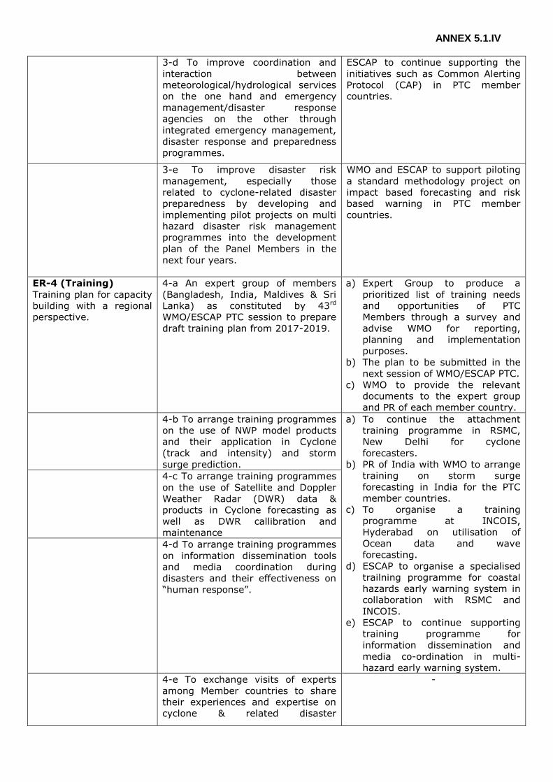
ANNEX 5.1.IV
3-d To improve coordination and
interaction between
meteorological/hydrological services
on the one hand and emergency
management/disaster response
agencies on the other through
integrated emergency management,
disaster response and preparedness
programmes.
ESCAP to continue supporting the
initiatives such as Common Alerting
Protocol (CAP) in PTC member
countries.
3-e To improve disaster risk
management, especially those
related to cyclone-related disaster
preparedness by developing and
implementing pilot projects on multi
hazard disaster risk management
programmes into the development
plan of the Panel Members in the
next four years.
WMO and ESCAP to support piloting
a standard methodology project on
impact based forecasting and risk
based warning in PTC member
countries.
ER-4 (Training)
Training plan for capacity
building with a regional
perspective.
4-a An expert group of members
(Bangladesh, India, Maldives & Sri
Lanka) as constituted by 43rd
WMO/ESCAP PTC session to prepare
draft training plan from 2017-2019.
a) Expert Group to produce a
prioritized list of training needs
and opportunities of PTC
Members through a survey and
advise WMO for reporting,
planning and implementation
purposes.
b) The plan to be submitted in the
next session of WMO/ESCAP PTC.
c) WMO to provide the relevant
documents to the expert group
and PR of each member country.
4-b To arrange training programmes
on the use of NWP model products
and their application in Cyclone
(track and intensity) and storm
surge prediction.
a) To continue the attachment
training programme in RSMC,
New Delhi for cyclone
forecasters.
b) PR of India with WMO to arrange
training on storm surge
forecasting in India for the PTC
member countries.
c) To organise a training
programme at INCOIS,
Hyderabad on utilisation of
Ocean data and wave
forecasting.
d) ESCAP to organise a specialised
trailning programme for coastal
hazards early warning system in
collaboration with RSMC and
INCOIS.
e) ESCAP to continue supporting
training programme for
information dissemination and
media co-ordination in multi-
hazard early warning system.
4-c To arrange training programmes
on the use of Satellite and Doppler
Weather Radar (DWR) data &
products in Cyclone forecasting as
well as DWR callibration and
maintenance
4-d To arrange training programmes
on information dissemination tools
and media coordination during
disasters and their effectiveness on
“human response”.
4-e To exchange visits of experts
among Member countries to share
their experiences and expertise on
cyclone & related disaster
-

ANNEX 5.1.IV
management aspects.
4-f To enhance WMO’s fellowship
support on tropical cyclone related
programmes.
-
ER-5 (Research)
Enhanced capabilities of
Members to cope with
high impact weather
through research.
5-a To produce regional assessment
of the impact of climate change on
tropical cyclones.
To collect data/materials/papers
from the Member countries which
are relevant to the regional
assessment.
5-b To develop storm surge and
river flood coupling model over
specific river basins for forecasting
of coastal inundation.
-
5-c To update vulnerability maps for
various parameters like wind
force/peak storm surge etc., based
on latest available database.
-
ER-6 (Partnership)
Enhanced use of
forecasts and warnings
for tropical cyclones and
storm surges for decision
making and
implementation by
Members and partner
organizations.
6-a To promote exchange of
information and data among
Members to enhance regional
cooperation in meteorology,
hydrology, DRR, training and
research.
-
6-b To enhance cooperation with
other regional bodies, organizations,
service providers and sectors for
more effective provision of the
forecasts and warnings.
-
6-c To develop proposals of joint
projects in the areas of five
components including resource
mobilization.
-
ER-7 (Management
and Governance)
Effective management
and functioning of the
Panel.
7.a To improve the coordination and
decision making process of the
Panel.
-
7.b To enhance effectiveness in
implementation of CTP and AOPs.
-
7.c To ensure effective and
collaborative relationships among
working groups of Meteorology,
Hydrology and DRR.
-

ANNEX 5.1.IV
7-d To improve coordinated
technical planning process as well as
monitoring and evaluation.
-

ANNEX 8.I
ANNEX 8.I
PTC SECRETARIAT REPORT
DURING THE INTERSESSIONAL PERIOD 2015-2016
The PTC report is based on the summary of the PTC Secretariat activities during the
intersessional period 2015-2016.
1. Pursuant upon the organization of 3rd Joint Session of the WMO/ESCAP Panel on
Tropical Cyclones (PTC) and ESCAP/WMO Typhoon Committee (TC)
(WMO/ESCAP/PTC-42 Session | ESCAP/WMO/TC-47 Session) in Bangkok, Thailand,
from 9 to 13 February 2015. PTC Secretariat collected input/feedback from the Panel
Member countries and other participating international organizations under the
auspicious of WMO and ESCAP and arranged / compiled the PTC-42 final report.
2. In order to enhance the visibility of the of activities of the WMO/ESCAP Panel on
Tropical Cyclones beyond the Panel region and to increase its Membership, PTC
Secretariat extended invitation to UAE, Qatar and Yemen for participation in the 3rd
Joint Session of PTC/TC (Bangkok, Thailand, 9-13 February, 2015). Yemen showed
interest for the membership of PTC. PTC Secretariat, under the guidance of WMO,
extend full coordinated with Yemen for its membership to Panel on Tropical Cyclones,
and extend invitation for attending PTC-43 as an observer.
3. PTC Secretariat collected contributions from Member countries for PTC Newsletters and
published PTC Newsletter “Panel News” (Issue No.39, 40) and distributed the e-version
issue among the PTC Member countries, WMO, UN-ESCAP and other international
organizations.
4. As per decision of 3rd Joint Session of WMO/ESCAP Panel on Tropical Cyclones (PTC)
and ESCAP/WMO Typhoon Committee (TC) (Bangkok, Thailand from 9-13 February,
2015), the Japan Meteorological Agency (JMA) organized Attachment Training for three
tropical cyclone forecasters one each from PTC Member countries Bangladesh, Maldives,
and Myanmar. The Attachment Training was held at RSMC, Tokyo, Japan from 22 to 31
July, 2015. Financial support in lieu of travel and per diem for the participants was
arranged through JMA’s VCP Fund maintained by WMO. PTC Secretariat, upon WMO’s
advice, extended invitation to the concerned PTC Member countries for inviting
nominations for the attachment training.
5. With the support of the Panel, Secretary of PTC represented PTC at Seventy-first
Session of ESCAP (Phase-II) (Bangkok, Thailand from 25-29 May, 2015). The
opportunity was also used to share PTC programmes and activities, and to highlight the
cooperation of PTC with the other regional body of WMO/ESCAP Typhoon Committee
(TC) in joint SSOP project. At the platform of ESCAP, the Secretary of PTC made the
following statement:
a. “The WMO/ESCAP Panel on Tropical Cyclones (PTC) is working to strengthen
regional cooperation among countries affected by tropical cyclones in the Bay of
Bengal and the Arabian Sea. This year, a particular highlight of our work is the
Joint Session held in cooperation with the ESCAP/WMO Typhoon Committee (TC)
and hosted by ESCAP here in Bangkok in February this year. This was the first
time in 18 years that such a joint session was held. In this session, the PTC and
the TC agreed on mechanism for future cooperation, including joint projects and
human capacity building trainings. We are now working to take this positive
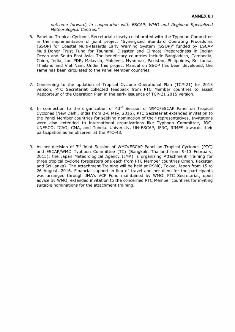
ANNEX 8.I
outcome forward, in cooperation with ESCAP, WMO and Regional Specialized
Meteorological Centres.”
6. Panel on Tropical Cyclones Secretariat closely collaborated with the Typhoon Committee
in the implementation of joint project “Synergized Standard Operating Procedures
(SSOP) for Coastal Multi-Hazards Early Warning System (SSOP)” funded by ESCAP
Multi-Donor Trust Fund for Tsunami, Disaster and Climate Preparedness in Indian
Ocean and South East Asia. The beneficiary countries include Bangladesh, Cambodia,
China, India, Lao PDR, Malaysia, Maldives, Myanmar, Pakistan, Philippines, Sri Lanka,
Thailand and Viet Nam. Under this project Manual on SSOP has been developed, the
same has been circulated to the Panel Member countries.
7. Concerning to the updation of Tropical Cyclone Operational Plan (TCP-21) for 2015
version, PTC Secretariat collected feedback from PTC Member countries to assist
Rapporteur of the Operation Plan in the early issuance of TCP-21 2015 version.
8. In connection to the organization of 43rd Session of WMO/ESCAP Panel on Tropical
Cyclones (New Delhi, India from 2-6 May, 2016), PTC Secretariat extended invitation to
the Panel Member countries for seeking nomination of their representatives. Invitations
were also extended to international organizations like Typhoon Committee, IOC-
UNESCO, ICAO, CMA, and Tohoku University, UN-ESCAP, IFRC, RIMES towards their
participation as an observer at the PTC-43.
9. As per decision of 3rd Joint Session of WMO/ESCAP Panel on Tropical Cyclones (PTC)
and ESCAP/WMO Typhoon Committee (TC) (Bangkok, Thailand from 9-13 February,
2015), the Japan Meteorological Agency (JMA) is organizing Attachment Training for
three tropical cyclone forecasters one each from PTC Member countries Oman, Pakistan
and Sri Lanka). The Attachment Training will be held at RSMC, Tokyo, Japan from 15 to
26 August, 2016. Financial support in lieu of travel and per diem for the participants
was arranged through JMA’s VCP Fund maintained by WMO. PTC Secretariat, upon
advice by WMO, extended invitation to the concerned PTC Member countries for inviting
suitable nominations for the attachment training.
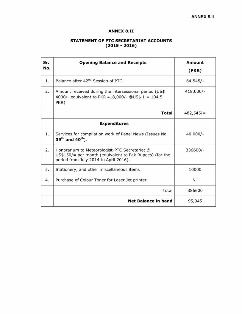
ANNEX 8.II
ANNEX 8.II
STATEMENT OF PTC SECRETARIAT ACCOUNTS
(2015 - 2016)
Sr.
No.
Opening Balance and Receipts Amount
(PKR)
1. Balance after 42nd Session of PTC 64,545/-
2. Amount received during the intersessional period (US$
4000/- equivalent to PKR 418,000/- @US$ 1 = 104.5
PKR)
418,000/-
Total 482,545/=
Expenditures
1. Services for compilation work of Panel News (Issues No.
39th and 40th).
40,000/-
2. Honorarium to Meteorologist-PTC Secretariat @
US$150/= per month (equivalent to Pak Rupees) (for the
period from July 2014 to April 2016).
336600/-
3. Stationery, and other miscellaneous items 10000
4. Purchase of Colour Toner for Laser Jet printer Nil
Total 386600
Net Balance in hand 95,945

ANNEX 9.I
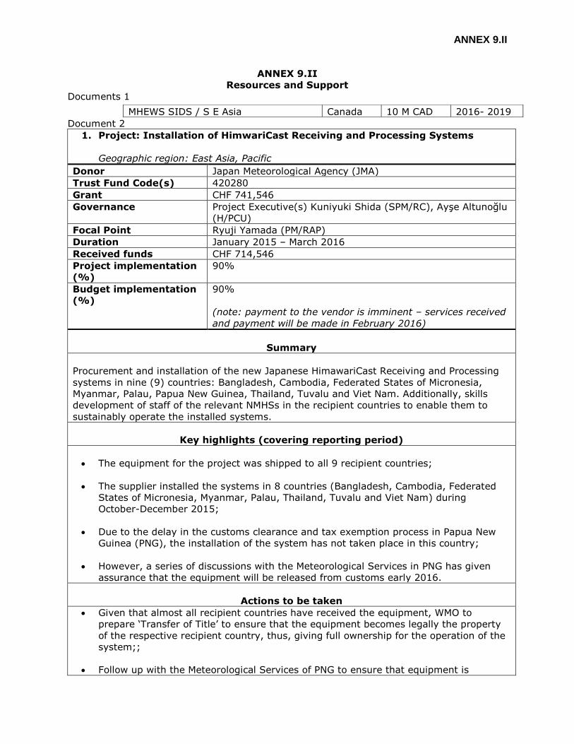
ANNEX 9.II
ANNEX 9.II
Resources and Support
Documents 1
Document 2
1. Project: Installation of HimwariCast Receiving and Processing Systems
Geographic region: East Asia, Pacific
Donor Japan Meteorological Agency (JMA)
Trust Fund Code(s) 420280
Grant CHF 741,546
Governance Project Executive(s) Kuniyuki Shida (SPM/RC), Ayşe Altunoğlu
(H/PCU)
Focal Point Ryuji Yamada (PM/RAP)
Duration January 2015 – March 2016
Received funds CHF 714,546
Project implementation
(%)
90%
Budget implementation
(%)
90%
(note: payment to the vendor is imminent – services received
and payment will be made in February 2016)
Summary
Procurement and installation of the new Japanese HimawariCast Receiving and Processing
systems in nine (9) countries: Bangladesh, Cambodia, Federated States of Micronesia,
Myanmar, Palau, Papua New Guinea, Thailand, Tuvalu and Viet Nam. Additionally, skills
development of staff of the relevant NMHSs in the recipient countries to enable them to
sustainably operate the installed systems.
Key highlights (covering reporting period)
The equipment for the project was shipped to all 9 recipient countries;
The supplier installed the systems in 8 countries (Bangladesh, Cambodia, Federated
States of Micronesia, Myanmar, Palau, Thailand, Tuvalu and Viet Nam) during
October-December 2015;
Due to the delay in the customs clearance and tax exemption process in Papua New
Guinea (PNG), the installation of the system has not taken place in this country;
However, a series of discussions with the Meteorological Services in PNG has given
assurance that the equipment will be released from customs early 2016.
Actions to be taken
Given that almost all recipient countries have received the equipment, WMO to
prepare ‘Transfer of Title’ to ensure that the equipment becomes legally the property
of the respective recipient country, thus, giving full ownership for the operation of the
system;;
Follow up with the Meteorological Services of PNG to ensure that equipment is
MHEWS SIDS / S E Asia Canada 10 M CAD 2016- 2019
ANNEX 9.II
released from customs as early as possible;
Hold discussions with the donor, JMA, regarding their intension of requesting the
addition of more recipient countries (country identification; funding is available in the
Trust Fund);
Prepare final narrative and financial report on the project expected to be completed in
March 2016;
Prepare a draft WMO press release on the project and the recipient countries (focusing
on the impact based forecasting potential offered by the system).
2. Project: Installation of a Doppler radar system in Sri Lanka
Geographic region: Asia
Donor Government of Sri Lanka
Trust Fund Code(s) 421109
Grant USD 2,931,480
Governance Project Executive Robert Masters (D/DRA)
Focal Point Kuniyuki Shida (SPM/RC)
Duration May 2007 - December 2016
Received funds USD 2,931,480
Project implementation
(%)
60%
Budget implementation
(%)
52 %
Summary
Procurement and installation of a Doppler weather radar system for the Department of
Meteorology of Sri Lanka.
Key highlights (covering reporting period)
No highlights for this reporting period.
Actions to be taken
Pending the receipt of the response from the Ministry of Disaster Management and
taking into consideration that the new Minister and the Secretary of the Ministry of
Disaster Management were appointed in October 2015 after the general election in the
country in August and Prof. Taalas assumed the post of SG of WMO on 1 January
2016, a new WMO letter to the Secretary of the Ministry of Disaster Management will
be sent in January 2016 to expedite the response from Sri Lanka;
The Ministry of Disaster Management will send an official letter to WMO confirming
that the damaged equipment should be repaired using the remaining funds in the
Trust Fund;
Once agreed by Sri Lanka and WMO, the current PO will be revised to accommodate
proposed actions.
DOM will send the equipment back to the factory of EEC for inspection. EEC will submit
the cost proposal to WMO;

ANNEX 9.II
EEC will repair the damaged equipment and send the equipment back to DOM with
some replacements;
The radar system will be installed at the radar site;
In parallel, the relevant authorities of Sri Lanka including DOM should conduct the
construction work to repair the damage road leading to the radar site.

ANNEX 9.III
ANNEX 9.III
TERMS OF REFERENCE OF THE WORKING GROUPS
TERMS OF REFERENCE OF THE PTC WORKING GROUP ON METEOROLOGY (WGM)
In order to coordinate efforts in the implementation of various programmes and activities
related to meteorology with the aim to better support the socio-economic development
process in the PTC region and to help accomplish the strategic goals and objectives as
mentioned under the Meteorological Component of the Coordinated Technical Plan of the
WMO/ESCAP Panel on Tropical Cyclones (PTC) for the Bay of Bengal and the Arabian Sea,
the PTC has established the Working Group on Meteorology (WGM) as decided during 39th
Session of PTC (Myanmar, 5-9 March, 2012) with the following Terms of Reference and
operational modalities.
Terms of Reference
The WGM will promote cooperation among the Members in the implementation of various
programmes and activities under the Meteorological Component of the PTC’s Coordinated
Technical Plan with the aim to support the socio-economic development process and
enhance cooperation among the Members in all the five major components towards this
end. The WGM is expected to advise and assist the PTC in:
Identifying priority issues and areas of cooperation in the Meteorological Component;
Promoting and facilitating the exchange of experiences and knowledge on the latest
developments and techniques related to the above issues and areas;
Coordinating and implement priority activities and programmes of the PTC aiming at
strengthening capacity of the Members in meteorology;
Mobilizing resources to carry out priority activities of the PTC related to the
Meteorological Component;
Developing Annual Operating Plan (AOP) for meteorology and reporting on the
activities under the AOP;
Reporting overall progress in the implementation of the Meteorological Component of
the PTC’s Coordinated Technical Plan;
Recommending to the PTC’s priority areas, programmes and activities for
cooperation in meteorological research by related experts of the Members; and
Performing any other task as assigned by the PTC.
Membership
The WGM consists of the following members:
Mrs. Sunitha Devi, India as Chairperson
Mr. Khalid Ahmed Al-Wahaibi, Oman as Vice-Chair
Mr Ali Shareef, Maldives as Vice-Chair
Members of other 6 countries
The PTC invites WMO and ESCAP to continue their involvement in the work of WG-M. The
PTC also requests the other concerned agencies to participate in the activities of WGM. The
term of service on the WGM is 1 year, which shall be automatically extended for similar
durations unless modified or terminated by the PTC.
ANNEX 9.III
Operation modalities
In view of the limited financial resources of the PTC Trust Fund, the WG-M is expected to
perform its work through email and other means. The WGM shall hold meeting during the
annual Session of PTC. The WG-M members, however, may also meet during the inter-
sessional period, if so necessary.
Reporting requirements
The Chairperson of the WGM is required to report to the PTC on overall progress in the
implementation of the Meteorological Component of the Coordinated Technical Plan as well
as on the activities with regards to the AOP for meteorology through the PTC Secretariat to
the PTC Chairperson and the PTC Members for their consideration under the framework of
the PTC. This report may also include recommendations related to priority activities to be
undertaken in the coming years.
TERMS OF REFERENCE OF THE PTC WORKING GROUP ON HYDROLOGY (WGH)
In order to coordinate efforts on the implementation of various programmes and activities
related to hydrology with the aim to better support the socio-economic development
process in the PTC region and to help accomplish the strategic goals and objectives as
mentioned under the Hydrological Component of the Coordinated Technical Plan of the
WMO/ESCAP Panel on Tropical Cyclones (PTC) for the Bay of Bengal and the Arabian Sea,
the PTC has established Working Group on Hydrology (WGH), as decided during 39th
Session of PTC (Myanmar, 5-9 March, 2012) with the following Terms of Reference and
operational modalities.
Terms of Reference
The WGH will promote cooperation among the Members in the implementation of various
programmes and activities under the Hydrological Component of the PTC’s Coordinated
Technical Plan with the aim to support the socio-economic development process and
enhance cooperation among the Member in all the five major components towards this end.
The WGH is expected to advise and assist the PTC in:
Identifying priority issues and areas of cooperation in the Hydrological Component;
Promote and facilitating the exchange of experiences and knowledge on the latest
developments and techniques related to the above issues and areas;
Coordinating and implement priority activities and programmes of the PTC aiming at
strengthening capacity of the Members in hydrology and water resources;
Mobilizing resources to carry out priority activities of the PTC related to the
Hydrological Component;
Developing Annual Operating Plan (AOP) for hydrology and reporting on the activities
under the AOP;
Reporting overall progress in the implementation of the Hydrological Component of
PTC’s Coordinated Technical Plan;
Recommending to the PTC’s priority areas, programmes and activities for
cooperation in hydrological research by related experts of the Members; and
Performing any other task as assigned by the PTC
Membership

ANNEX 9.III
All Member countries will be represented at the WGH.
Pakistan, Myanmar, Bangladesh will be the Chair and Vice-chairs of the WGH respectively.
The PTC invites WMO and ESCAP to continue their involvement in the work of WGH. The PTC
also requests to other concerned agencies to participate in the activities of WG-H.
The term of service on the WGH is 1 year, which shall be automatically extended for similar
durations unless modified or terminated by the PTC.
Operation Modalities
In view of the limited financial resources of the PTC Trust Fund, the WGH is expected to
perform its work through email and other means. The WG members shall meet if necessary.
Reporting Requirements
The Chairperson of the WGH is required to submit annual report on WGH activities with
regards to the implementation of Coordinated Technical Plan through PTC Secretariat to the
PTC Chairperson and the PTC Members for their consideration under the framework of the
PTC. This report will include recommendations related to priority activities to be undertaken
in the coming years.
TERMS OF REFERENCE OF THE PTC WORKING GROUP ON DRR (WGDRR)
In order to coordinate efforts on the implementation of various activities under the Disaster
Risk Reduction (DRR) Component to better support the socio-economic development
process in the Panel on Tropical Cyclones (PTC) Area and to help accomplish the DRR
related goals and objectives in the Coordinated Technical Plan (CTP) 2009-2011, PTC
established the Working Group on Disaster Prevention and Preparedness, later renamed to
the Working Group on Disaster Risk Reduction (WGDRR), with the following Terms of
Reference and operational modalities.
Terms of Reference
The WGDRR will promote cooperation among the PTC Members in the implementation of
activities under the DRR Component of the PTC’s Coordinated Technical Plan to support the
socio-economic development process and enhance cooperation among the Members in all
the five components towards this end, the WGDRR is expected to advise and assist the PTC:
Identifying priority issues and areas of cooperation in the DRR Component;
Promoting and facilitating the exchange of experiences and knowledge on the latest
developments and techniques related to the above issues and areas;
Coordinating and implementing priority activities of the AOP and programmes of
the PTC aiming at strengthening capacity of the Members in DRR;
Mobilizing resources to carry out priority activities of the PTC related to the DRR
Component;
Monitoring and evaluating overall progress in the implementation of the DRR
Component of the Coordinated Technical Plan;
Recommending to the PTC priority areas, programmes and activities for
cooperation in DRR research by experts of the Members;

ANNEX 9.III
Promoting measures for more effective cooperation with other components of work
of the Panel, including the development of the conceptual framework on multi-
hazard early warning systems and public outreach programs; and,
Reporting overall progress in the implementation of the DRR component of the
CTP.
Membership
The WGDRR will consist of the following members: - Mr. Adthaporn Singhwichai, Thailand; as Chairperson
- Mr. Captain Faisal, Oman; as Vice Chairperson
- Members of other 7 countries
The PTC invites ESCAP and WMO to continue their involvement in the work of WGDRR. The
PTC also requests the other concerned agencies to participate in the activities of WGDRR.
The term of service on the WGDRR is 1 year, which shall be automatically extended for
similar durations unless modified or terminated by the PTC.
Operation modalities
In view of the limited financial resources of the PTC Trust Fund, the WGDRR is expected to
perform its work through email and other means. The WG members shall meet if necessary.
Reporting requirements
The Chairperson of the WGDRR is required to submit an annual report on DRR activities with
regards to the implementation of Coordinated Technical Plan through the PTC Secretariat to
the PTC Chairperson and the PTC Members for their consideration under the framework of
the PTC. This report will include recommendations related to priority activities to be
undertaken in the coming years.

ANNEX 9.IV
ANNEX 9.IV
TERMS OF REFERENCE FOR THE PANEL ON TROPICAL CYCLONES SECRETARIAT
The Panel on Tropical Cyclones (PTC) Secretariat will coordinate the Panel's programme in
close consultation with the WMO and ESCAP Secretariats. The PTC Secretariat will report to
the Panel at regular intervals on the progress of the work so far undertaken. Specifically, to
the extent that its available resources permit, the PTC Secretariat shall:
(1) Assist the Members as administrative, documentary, and information centre of
the Panel on Tropical Cyclones;
(2) Implement the PTC decisions and coordinate and monitor the implementation of
the PTC Annual Operating Plan;
(3) Maintain close contact with the Panel Members and other relevant organization
by correspondence and coordination to carry out all matters related to
implementation of recommended programmes;
(4) Follow up decisions of Panel meetings and related activities such as those
concerning other regional tropical cyclone bodies, or the General Component of
the WMO Tropical Cyclone Programme (TCP) with assistance from WMO;
(5) Manage the operation and promote the use of the PTC website;
(6) Participate and organize the annual session of the Panel with assistance and
guidance from WMO/ ESCAP including documentation;
(7) Process and take necessary action promptly on correspondence from Panel
Members, WMO, and other sources;
(8) Enhance visibility of the PTC in cooperation with Panel Members including editing
and publishing of PTC news Letter;
ANNEX 9.IV
ANNEX 9.V
SUPPORT FOR THE PANEL’S PROGRAMME
International Network for Multi-Hazard Early Warning Systems
(NM-HEWS) in Asia and the Pacific
(Submitted by UN-ESCAP)
In the last decade, the Asia-Pacific region had 1,624 reported disasters. From
these, approximately 400,000 people lost their lives, and around 1.4 billion were
suffered.10 Disasters continued to undermine hard-won development gains across the
region, and impacts of disasters constitute a serious threat to the attainment of the
Sustainable Development Goals (SDGs), and thus, in the Asia-Pacific, building resilience
to disasters is not a matter of choice.
Establishing proper early warning systems is a critical element in protecting our
development gains, and the Sendai Framework for Disaster Risk Reduction 2015-
2030(the Sendai Framework) recognizes the importance of early warning systems (EWS)
in reducing the disaster risk. These early warning systems should cover multi-hazards
considering the cascading impacts of natural hazards and climate change. Accordingly,
the Sendai Framework calls for enhancing and strengthening multi‐hazard early warning
systems (MHEWS).
In response to this call, the International Network for Multi‐Hazard Early
Warning Systems (IN‐MHEWS)is being established as a multi‐stakeholder partnership
that will facilitate the sharing of expertise and good practices for MHEWS. As a broad-
based networking initiative on early warning, IN-MHEWS is not meant to be an
operational network of MHEWS. Instead, it will exemplify the importance of multi-
stakeholder cooperation in MHEWS as a way to advocate the implementation and/or
improvement of multi-hazard early warning systems, to compile and disseminate lessons
learned regarding early warning systems, and to increase the efficiency of investments in
MHEWS for societal resilience.
Member States of ESCAP also recognized the need to strengthen people-centred
multi-hazard early warning systems and requested the ESCAP secretariat to work on
multi-hazard early warning systems at the regional level through the Commission
resolution 71/12 adopted in May 2015. Accordingly, ESCAP outlined a concept multi-
hazard early warning system as the regional component of WMO-led IN-MHEWS, based
on ESCAP’s experience in regional mechanisms including
Panel on Tropical Cyclones,
Typhoon Committee, and
Regional Drought Mechanisms and Multi-donor Trust Fund on Tsunami, Disaster
and Climate Preparedness.
ESCAP's new initiatives on regional cooperation mechanism for flood forecasting
and early warning in transboundary river basins, and putting in place a research
network(s) for flash floods, GLOFS and landslides highlight its ongoing efforts towards
strengthening multi-hazard regional early warning systems in the region (Figure).

ANNEX 9.IV
ESCAP with partners has also developed the tools for multi-sectoral impact
assessment of slow-onset disasters - which were used for 2015/2016 El Nino Impact
Outlook in Asia and the Pacific.
Under the agenda item 9.4, the concept will be presented for the discussion with
PTC member Countries.