Embed Size (px)
Citation preview
8/14/2019 Winslow Way Assessments
http://slidepdf.com/reader/full/winslow-way-assessments 1/26
CITY OF BAINBRIDGE ISLAND
CITY COUNCIL AGENDA BILL PROCESS INFORMATION
Subject: Subject: Winslow Way Reconstruction Project -
Resolution of Intention to Form Local Improvement District
Date: August 26, 2009
Agenda Item: Resolution Bill No.:
Proposed By: Christopher Wierzbicki, PE Referral(s):
BUDGET INFORMATION
Department: PCD/PW Fund: N/A Munis Contract # N/A
Expenditure Req: N/A Budgeted? Yes No Budget Amend. Req? Yes
STANDING COMMITTEE INFORMATION
Referring Committee: FPC Recommendation:
Date of Referral: August 4th Vote __ – Yea __ – Ney Minority Report Yes N
DESCRIPTION/SUMMARY
Action Item:
8/14/2019 Winslow Way Assessments
http://slidepdf.com/reader/full/winslow-way-assessments 2/26
CITY OF BAINBRIDGE ISLAND
WINSLOW WAY IMPROVEMENT PROJECT
AGREEMENT AND PETITION
1. AGREEMENT AND PETITION
1.1 This Winslow Way Improvement Project Agreement and Petition (“Agreemenis between the City of Bainbridge Island, a Washington municipal corporation (“City”), a
the Owners of certain property identified in Exhibit A (Appendix 1 – 21) to this Agreeme
(collectively, “Owners”). The City and Owners agree as set forth in this Agreement.
1.2 This Agreement also constitutes the petition of Owners for the formation oflocal improvement district for the improvement of Winslow Way, as further described herein
2. PROPERTY OWNERS’ PETITION
2.1 Owners’ Property. Owners are the owners of property described specifically
Appendix 1 – 21 (the “Property”).
2.2 Improvements. The City is considering the improvement of Winslow Way autility infrastructure serving the Property (the “Improvements”), and described as follows:
8/14/2019 Winslow Way Assessments
http://slidepdf.com/reader/full/winslow-way-assessments 3/26
3. PROPERTY SPECIALLY BENEFITED
The Property will receive special benefit in at least the amount set forth in attachExhibit C (“Property Assessment”) as a result of the construction of the Improvements. Owne
agree that this Property Assessment is not an estimate of special benefit. A complete schedule the Property and Property Assessments within the LID is set forth in Exhibit C.
4. CREATION OF LID
4.1 Subject to compliance with federal and state law, the City shall entertain t
creation of an LID for the Improvements. Should the City elect to proceed with such an LIthe City shall order and carry out the construction of the Improvements as expeditiously
practicable. The City shall also exert its best efforts to finance the cost of the Improvemenin part, with proceeds from special benefit assessments levied against the Property within t
LID, and identified in Exhibit C. It is understood by the parties to this Agreement th
nothing contained herein shall be construed to bind the City to the creation of an LID, or to t
levying of assessments or other action under Title 35 RCW. The City in its sole discretimay order the construction of less than all of the Improvements, and may create one or mo
local improvement districts within the boundaries set forth in attached Exhibit A to carry oas many of the Improvements as the City orders to be constructed.
4.2 As to any LID formed under any provision of this Agreement, Owners retain ti h h ifi f i P A l
8/14/2019 Winslow Way Assessments
http://slidepdf.com/reader/full/winslow-way-assessments 4/26
proceeding affecting this Agreement shall be laid in the Superior Court of the State
Washington in Kitsap County.
5.4 Binding Successors. This Agreement shall be binding on the successors, assign
heirs, administrators and executors of the parties hereto. To that end, this Agreement may recorded by the City at its discretion.
5.5 Termination. If the LID is not formed within eighteen (18) months of t
Effective Date, this Agreement shall terminate and be of no further force and effect.
5.6
Entire Agreement and Severability. This Agreement is the entire understandibetween the parties, and no changes, amendments or alterations shall be effected unless agre
to in writing and signed by both parties. If any provision of this Agreement is finaldetermined by a court of competent jurisdiction to be invalid or unenforceable, the remaind
of the provisions of this Agreement shall remain in full force and effect, provided, however,
the event the invalid or unenforceable provision is a material part of the consideration for th
Agreement, this Agreement shall thereby be rendered voidable at the option of either parThe option to void this Agreement shall be exercised by sending written notice to the oth
party no later than ten (10) business days after the court’s determination becomes final or toption shall thereafter be deemed to be waived.
6. EXECUTION AND EFFECTIVE DATE
8/14/2019 Winslow Way Assessments
http://slidepdf.com/reader/full/winslow-way-assessments 5/26
STATE OF WASHINGTON
COUNTY OF
_________________________
ss.
I certify that I know or have satisfactory evidence that Mark Dombroski is the persowho appeared before me, and said person acknowledged that said person signed this instrumen
on oath stated that said person was authorized to execute the instrument and acknowledged it the City Manager of the City of Bainbridge Island, a Washington municipal corporation, to be tfree and voluntary act of such corporation for the uses and purposes mentioned in the instrumen
Dated this ____ day of _________________________, 2009.
(Signature of Notary)
(Legibly Print or Stamp Name of Notary)
Notary public in and for the State of Washington,
8/14/2019 Winslow Way Assessments
http://slidepdf.com/reader/full/winslow-way-assessments 6/26
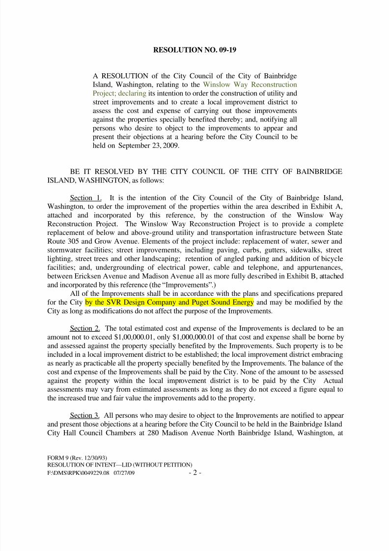
RESOLUTION NO. 09-19
A RESOLUTION of the City Council of the City of BainbridgeIsland, Washington, relating to the Winslow Way ReconstructionProject; declaring its intention to order the construction of utility andstreet improvements and to create a local improvement district toassess the cost and expense of carrying out those improvementsagainst the properties specially benefited thereby; and, notifying allpersons who desire to object to the improvements to appear and
present their objections at a hearing before the City Council to beheld on September 23, 2009.
BE IT RESOLVED BY THE CITY COUNCIL OF THE CITY OF BAINBRIDGISLAND, WASHINGTON, as follows:
Section 1. It is the intention of the City Council of the City of Bainbridge Islan
Washington, to order the improvement of the properties within the area described in Exhibit attached and incorporated by this reference, by the construction of the Winslow WReconstruction Project. The Winslow Way Reconstruction Project is to provide a complereplacement of below and above-ground utility and transportation infrastructure between Sta
8/14/2019 Winslow Way Assessments
http://slidepdf.com/reader/full/winslow-way-assessments 7/26
7:30 p.m. on September 23, 2009 which time and place are fixed for hearing all matters relatingthe Improvements and all objections thereto and for determining the method of payment for t
Improvements. All persons who may desire to object thereto should appear and present theobjections at that hearing. Any person who may desire to file a written protest with the City Counmay do so within 30 days after the date of passage of the ordinance ordering the Improvements the event the local improvement district is formed. The written protest should be signed by tproperty owner and should include the legal description of the property for which the protest is filand that protest should be delivered to the City Clerk.
Section 4. The city clerk is authorized and directed to give notice of the adoption of thi
resolution and of the date, time, and place fixed for the public hearing to each owner or reputed
owner of any lot, tract, parcel of land, or other property within the proposed local improvement
district by mailing such notice at least fifteen (15) days before the date fixed for public hearing
the owner or reputed owner of the property as shown on the rolls of the Kitsap County Assesso
at the address shown thereon, as required by law.This resolution also shall be published in its entirety in at least two consecutive issues o
the official newspaper of the City, the date of the first publication to be at least fifteen (15) day
8/14/2019 Winslow Way Assessments
http://slidepdf.com/reader/full/winslow-way-assessments 8/26
Mayor
ATTEST/AUTHENTICATE:
__________________________________
City Clerk
APPROVED AS TO FORM:
__________________________________City Attorney
8/14/2019 Winslow Way Assessments
http://slidepdf.com/reader/full/winslow-way-assessments 9/26
I, #_________________________#, City Clerk of the City of Bainbridge IslanWashington, certify that the attached copy of Resolution No. #______# is a true and correct copy
the original resolution passed on the ______ day of #______________, 20___#; as such resolutiappears on the Minute Book of the City.
DATED this ______ day of #________________, 20___#.
City Clerk
8/14/2019 Winslow Way Assessments
http://slidepdf.com/reader/full/winslow-way-assessments 10/26
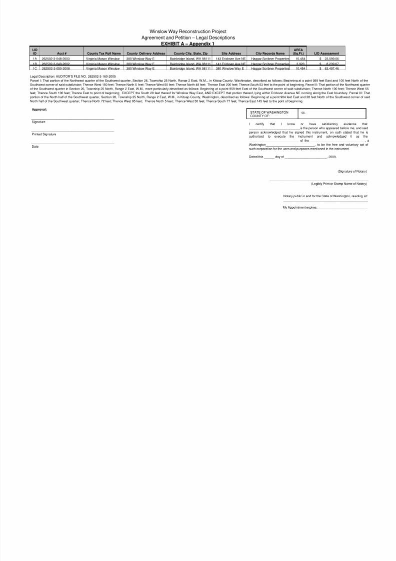
Winslow Way Reconstruction Project
Agreement and Petition – Legal Descriptions
EXHIBIT A – Appendix 1
LIDID Acct # County Tax Roll Name County Delivery Address County City, State, Zip Site Address City Records Name
AREA(Sq.Ft.) LID Assessment
1A 262502-3-048-2003 Virginia Mason Winslow 380 Winslow Way E Bainbridge Island, WA 98111 143 Ericksen Ave NE Haggar Scribner Properties 10,454 $ 23,599.06
1B 262502-3-049-2002 Virginia Mason Winslow 380 Winslow Way E Bainbridge Island, WA 98111 141 Ericksen Ave NE Haggar Scribner Properties 3,920 $ 8,239.67
1C 262502-3-050-2008 Virginia Mason Winslow 380 Winslow Way E Bainbridge Island, WA 98111 380 Winslow Way E Haggar Scribner Properties 10,454 $ 63,497.46
Legal Description: AUDITOR’S FILE NO. 262502-3-160-2005
Parcel I: That portion of the Northwest quarter of the Southwest quarter, Section 26, Township 25 North, Range 2 East, W.M.., in Kitsap County, Washington, described as follows: Beginning at a point 959 feet East and 100
Southwest corner of said subdivision; Thence West 150 feet; Thence North 5 feet; Thence West 50 feet; Thence North 48 feet; Thence East 200 feet; Thence South 53 feet to the point of beginning. Parcel II: That portion of the
of the Southwest quarter in Section 26, Township 25 North, Range 2 East, W.M., more particularly described as follows: Beginning at a point 959 feet East of the Southwest corner of said subdivision; Thence North 100 feet
feet; Thence South 100 feet; Thence East to point of beginning; EXCEPT the South 28 feet thereof for Winslow Way East, AND EXCEPT that portion thereof, lying within Erickson Avenue NE running along the East bounda
portion of the North half of the Southwest quarter, Section 26, Township 25 North, Range 2 East, W.M., in Kitsap County, Washington, described as follows: Beginning at a point 904 feet East and 28 feet North of the Southw
North half of the Southwest quarter; Thence North 72 feet; Thence West 95 feet; Thence North 5 feet; Thence West 50 feet; Thence South 77 feet; Thence East 145 feet to the point of beginning.
Approval:
_______________________________________________
Signature
_______________________________________________
Printed Signature
_______________________________________________
Date
__________________________________________
(S
_________________________________________
(Legibly Print or Stam
Notary public in and for the State of Wash
_________________________________
My Appointment expires: _____________
STATE OF WASHINGTONCOUNTY OF:
ss.
I certify that I know or have satisfactory
_____________________________is the person who appeared b
person acknowledged that he signed this instrument, on oath
authorized to execute the instrument and acknowled
____________________________ of the __________________
Washington____________________________, to be the free an
such corporation for the uses and purposes mentioned in the instru
Dated this ______ day of ________________________, 2009.
8/14/2019 Winslow Way Assessments
http://slidepdf.com/reader/full/winslow-way-assessments 11/26
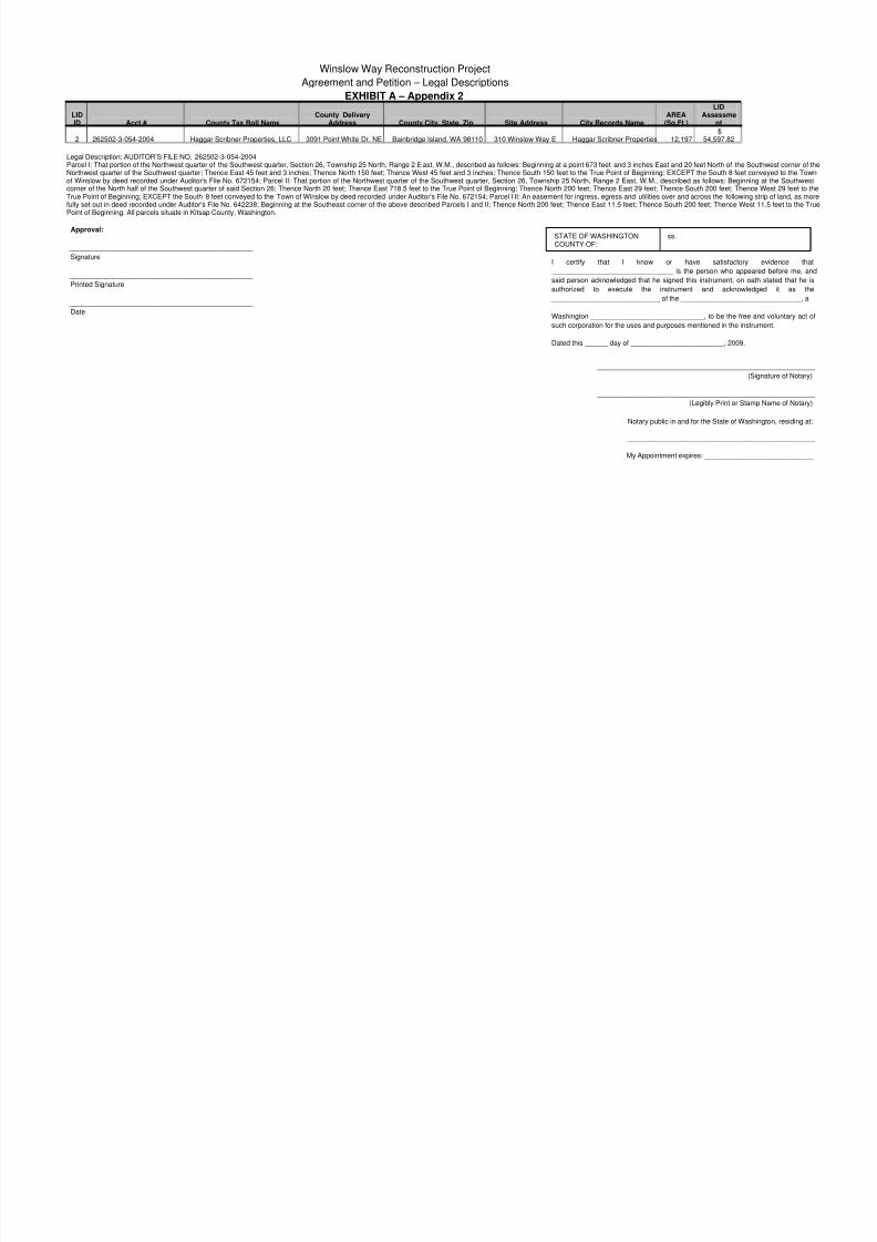
Winslow Way Reconstruction Project
Agreement and Petition – Legal Descriptions
EXHIBIT A – Appendix 2
LIDID Acct # County Tax Roll Name
County DeliveryAddress County City, State, Zip Site Address City Records Name
AREA(Sq.Ft.)
LIDAssessme
nt
2 262502-3-054-2004 Haggar Scribner Properties, LLC 3091 Point White Dr. NE Bainbridge Island, WA 98110 310 Winslow Way E Haggar Scribner Properties 12,197$
54,597.82
Legal Description: AUDITOR’S FILE NO. 262502-3-054-2004 Parcel I: That portion of the Northwest quarter of the Southwest quarter, Section 26, Township 25 North, Range 2 E ast, W.M., described as follows: Beginning at a point 673 feet and 3 inches East and 20 feet North of the SoutNorthwest quarter of the Southwest quarter; Thence East 45 feet and 3 inches; Thence North 150 feet; Thence West 45 feet and 3 inches; Thence South 150 feet to the True Point of Beginning; EXCEPT the South 8 feet convof Winslow by deed recorded under Auditor's File No. 672154; Parcel II: That portion of the Northwest quarter of the Southwest quarter, Section 26, Township 25 North, Range 2 East, W.M., described as follows: Beginning corner of the North half of the Southwest quarter of said Section 26; Thence North 20 feet; Thence East 718.5 feet to the True Point of Beginning; Thence North 200 feet; Thence East 29 feet; Thence South 200 feet; Thence WTrue Point of Beginning; EXCEPT the South 8 feet conveyed to the Town of Winslow by deed recorded under Auditor's File No. 672154; Parcel I II: An easement for ingress, egress and utilities over and across the following strfully set out in deed recorded under Auditor's File No. 642238; Beginning at the Southeast corner of the above described Parcels I and II; Thence North 200 feet; Thence East 11.5 feet; Thence South 200 feet; Thence West 1Point of Beginning. All parcels situate in Kitsap County, Washington.
Approval:
_______________________________________________
Signature
_______________________________________________
Printed Signature
_______________________________________________
Date
_________________________________________
(S
_________________________________________
(Legibly Print or Stam
Notary public in and for the State of Wash
_________________________________
My Appointment expires: _____________
STATE OF WASHINGTONCOUNTY OF:
ss.
I certify that I know or have satisfactory
_______________________________ is the person who appea
said person acknowledged that he signed this instrument, on oat
authorized to execute the instrument and acknowled
____________________________ of the ____________________
Washington _____________________________, to be the free a
such corporation for the uses and purposes mentioned in the instru
Dated this ______ day of ________________________, 2009.

8/14/2019 Winslow Way Assessments
http://slidepdf.com/reader/full/winslow-way-assessments 12/26
Winslow Way Reconstruction Project
Agreement and Petition – Legal Descriptions
EXHIBIT A – Appendix 3
LIDID Acct # County Tax Roll Name
County DeliveryAddress
County City, State,Zip Site Address City Records Name
AREA(Sq.Ft.) LID Assessment
3 262502-3-146-2004 Sandstrom Property, LLC 5725 NE 77th St. Seattle, WA 98115 278 Winslow Way E Sandstrom Property, LLC 39,640 $ 90,546.38
Legal Description: AUDITOR’S FILE NO. 262502-3-146-2004
Parcel I: That portion of the Northwest quarter of the Southwest quarter of Section 26, Township 25 North, Range 2 East, W.M., in Kitsap County, Washington, described as follows: Beginning at the Southwest corner of the Nothe Southwest quarter; Thence North 20 feet; Thence East 618.5 feet, Thence North 150 feet to the True Point of Beginning; Thence East 100 feet; Thence North 50 feet; Thence West 100 feet; Thence South 50 feet toBeginning; Parcel II: That portion of t he Northwest quarter of the Southwest quarter of Section 26 Township 25 North, Range 2 East, W.M., in Kitsap County, Washington, described as follows: Beginning at the Southwest cornof the Southwest quarter of said Section 26; Thence North 20 feet; Thence East 618.5 feet to the True Point of Beginning; Thence North 150 feet; Thence East 54 feet 9 inches; Thence South 150 feet; Thence West 54 feet 9 Point of Beginning; EXCEPT the South 8 feet; Parcel III: That portion of the Northwest quarter of the Southwest quarter, Section 26, Township 25 North, Range 2 East, W.M., in Kitsap County, Washington, described as followSouthwest corner of said Northwest quarter of the Southwest quarter; Thence North 20 feet; Thence East 477 feet to the True Point of Beginning; Thence continuing East 30 feet; Thence North 100 feet; Thence West 30 feet; feet to the True Point of Beginning; EXCEPT the South 8 feet; Parcel IV: That portion of the Northwest quarter of the Southwest quarter of Section 26, Township 25 North, Range 2 East, W.M., in Kitsap County, Washington, deBeginning at the Southwest corner of said Northwest quarter of the Southwest quarter; Thence North 20 feet; Thence East 507 feet to the True Point of Beginning; Thence East 111.5 feet; Thence North 310 feet; Thence West South 210 feet; Thence East 30 feet; Thence South 100 feet to the True Point of Beginning; EXCEPT the South 8 feet; EXCEPT that portion of the Northwest quarter of the Southwest quarter in Section 26, Township 25 NoW.M., described as follows: Beginning at the Southwest corner of the Northwest quarter of the Southwest quarter; Thence North 1°20'07” East along the West line of said Section, 20 feet; Thence South 88°41'21” East parallel said Northwest quarter of the Southwest quarter 4 77 feet; Thence North 1°20'07” East 200 feet and the True Point of Beginning; Thence continuing North 1°20'07” East 110 feet; Thence South 88°41'21” East 141.50 feet; ThenEast 110 feet; Thence North 88°41'21” West 141.50 feet to the True Point of Beginning; (Auditor's File No. 9610070207). Situate in the City of Bainbridge Island, Kitsap County, Washington.
Approval:
_______________________________________________
Signature
_______________________________________________
Printed Signature
_______________________________________________
Date
_________________________________________
(S
_________________________________________
(Legibly Print or Stam
Notary public in and for the State of Wash
_________________________________
My Appointment expires: _____________
STATE OF WASHINGTONCOUNTY OF:
ss.
I certify that I know or have satisfactory _________________________________ is the person who apand said person acknowledged that he signed this instrument, on
is authorized to execute the instrument and acknowle ____________________________ of the ____________________Washington _____________________________, to be the free asuch corporation for the uses and purposes mentioned in the instruDated this ______ day of ________________________, 2009.

8/14/2019 Winslow Way Assessments
http://slidepdf.com/reader/full/winslow-way-assessments 13/26
Winslow Way Reconstruction Project
Agreement and Petition – Legal Descriptions
EXHIBIT A – Appendix 4
LIDID Acct # County Tax Roll Name
County DeliveryAddress County City, State, Zip Site Address
CityRecords
NameAREA
(Sq.Ft.) LID Assessment
4 262502-3-056-2002 Winslow Hardware & Mercantile 1237 Hawley Way NE Bainbridge Island, WA 98110 240 Winslow Way E Schuricht 10,019 $ 31,498.74
Legal Description: AUDITOR’S FILE NO. 262502-3-056-2002
Resultant Parcel B of Boundary Line Adjustment recorded under Auditor's File No. 9410260234, described as follows: That portion of the Northwest quarter of the Southwest quarter of Section 26, Township 25 North, Range 2 E
County, Washington, described as follows: Beginning at the Southwest corner of said subdivision; Thence North, a distance of 28 feet; Thence East, a distance of 477 feet to the True Point of Beginning; Thence North, a distan
Thence West, a distance of 50 feet; Thence South, a distance of 202 feet to a point which is W est of the True Point of Beginning; Thence East a distance of 50 feet to the True Point of Beginning.
Approval:
_______________________________________________
Signature
_______________________________________________
Printed Signature
_______________________________________________
Date
_________________________________________
(S
_________________________________________
(Legibly Print or Stam
Notary public in and for the State of Wash
_________________________________
My Appointment expires: _____________
STATE OF WASHINGTONCOUNTY OF:
ss.
I certify that I know or have satisfactory
_______________________________ is the person who appea
said person acknowledged that he signed this instrument, on oat
authorized to execute the instrument and acknowled
____________________________ of the __________________
Washington corporation, to be the free and voluntary act of such
uses and purposes mentioned in the instrument.
Dated this ______ day of ________________________, 2009.
8/14/2019 Winslow Way Assessments
http://slidepdf.com/reader/full/winslow-way-assessments 14/26
Winslow Way Reconstruction Project
Agreement and Petition – Legal Descriptions
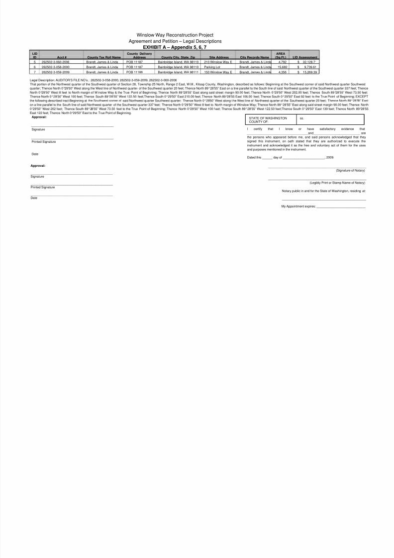
EXHIBIT A – Appendix 5, 6, 7
LIDID Acct # County Tax Roll Name
County DeliveryAddress County City, State, Zip Site Address City Records Name
AREA(Sq.Ft.) LID Assessment
5 262502-3-060-2006 Brandt, James & Linda POB 11187 Bainbridge Island, WA 98110 210 Winslow Way E Brandt, James & Linda 4,792 $ 32,128.71
6 262502-3-058-2000 Brandt, James & Linda POB 11187 Bainbridge Island, WA 98110 Parking Lot Brandt, James & Linda 15,682 $ 9,739.61
7 262502-3-059-2009 Brandt, James & Linda POB 11188 Bainbridge Island, WA 98111 150 Winslow Way E Brandt, James & Linda 4,356 $ 15,269.39
Legal Description: AUDITOR’S FILE NO’s.: 262502-3-058-2000, 262502-3-059-2009, 262502-3-060-2006
That portion of the Northwest quarter of the Southwest quarter of Section 26, Township 25 North, Range 2 East, W.M., Kitsap County, Washington, described as follows: Beginning at the Southwest corner of said Northwest q
quarter; Thence North 0°29'50” West along the West line of Northwest quarter of the Southwest quarter 20 feet; Thence North 89°28'55” East on a line parallel to the South line of said Northwest quarter of the Southwest quarte
North 0°29'50” West 8 feet to North margin of W inslow Way & the True Point of Beginning; Thence North 89°28'55” East along said street margin 90.00 feet; Thence North 0°29'50” West 202.00 feet; Thence South 89°28'55
Thence North 0°29'50” West 100 feet; Thence South 89°28'55” West 122.50 feet;Thence South 0°29'50” East 210.00 feet; Thence North 89°28'55 East 106.00 feet; Thence South 0°29'50” East 92 feet to the True Point of B
the following described tract:Beginning at the Southwest corner of said Northwest quarter Southwest quarter; Thence North 0°29'50” West along t he West line of Northwest quarter of the Southwest quarter 20 feet; Thence No
on a line parallel to the South line of said Northwest quarter of the Southwest quarter 337 feet; Thence North 0°29'50” West 8 feet to North margin of Winslow Way; Thence North 89°28'55” East along said street margin 90.00
0°29'50” West 202 feet; Thence South 89°28'55” West 73.50 feet to the True Point of Beginning; Thence North 0°29'50” West 100 f eet; Thence South 89°28'55” West 122.50 feet;Thence South 0°29'50” East 139 feet; Then
East 122 feet; Thence North 0°29'50” East to the True Point of Beginning.
Approval:
_______________________________________________
Signature
_______________________________________________
Printed Signature
_______________________________________________
Date
_________________________________________
(S
_________________________________________
(Legibly Print or Stam
Notary public in and for the State of Wash
_________________________________
My Appointment expires: _____________
STATE OF WASHINGTONCOUNTY OF:
ss.
I certify that I know or have satisfactory
___________________________________and________________
the persons who appeared before me, and said persons ackno
signed this instrument, on oath stated that they are authorize
instrument and acknowledged it as the free and voluntary act of
and purposes mentioned in the instrument.
Dated this ______ day of ________________________, 2009.
Approval:
_______________________________________________ Signature
_______________________________________________ Printed Signature
_______________________________________________ Date
8/14/2019 Winslow Way Assessments
http://slidepdf.com/reader/full/winslow-way-assessments 15/26
Winslow Way Reconstruction Project
Agreement and Petition – Legal Descriptions
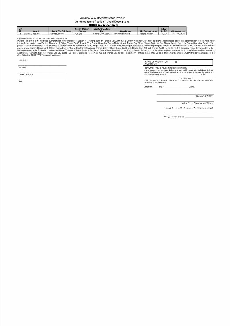
EXHIBIT A – Appendix 8
LIDID Acct # County Tax Roll Name
County DeliveryAddress
County City, State,Zip Site Address City Records Name
AREA(Sq.Ft.) LID Assessment
8 262502-3-062-2004 Roberts Jewelry POB 345 Indianola, WA 98342 194 Winslow Way E Roberts Jewelry 5,227 $ 20,979.16
Legal Description: AUDITOR’S FILE NO. 262502-3-062-2004
Parcel I: That portion of the Northwest quarter of the Southwest quarter of Section 26, Township 25 North, Range 2 East, W.M., Kitsap County, Washington, described as follows : Beginning at a point on the Southwest corner the Southwest quarter of said Section; Thence North 20 feet; Thence East 317 feet to True Point of Beginning; Thence North 100 feet; Thence East 20 feet; Thence South 100 feet; Thence West 20 feet to the Point of Beginni
portion of the Northwest quarter of the Southwest quarter of Section 26, Township 25 North, Range 2 East, W.M., Kitsap County, W ashington, described as follows: Beginning at a point on the Southwest corner of the North ha
quarter of said Section; Thence North 20 feet; Thence East 317 feet to True Point of Beginning Thence North 100 feet; Thence East 5 feet; Thence South 100 feet; Thence West 5 feet to the Point of Beginning; Parcel III: Th
Northwest quarter of the Southwest quarter of Section 26, Township 25 North, Range 2 East, W.M., Kitsap County, Washington, described as follows: Beginning at a point on the Southwest corner of the North half of the So
said Section; Thence North 20 feet; Thence East 282 feet to True Point of Beginning Thence North 100 feet; Thence East 30 feet; Thence South 100 feet; Thence West 30 feet to the Point of Beginning; EXCEPT that portio
City of Winslow; AND EXCEPT the West3 feet thereof;
Approval:
_______________________________________________
Signature
_______________________________________________
Printed Signature
_______________________________________________
Date
_________________________________________
(S
_________________________________________
(Legibly Print or Stam
Notary public in and for the State of Wash
_________________________________
My Appointment expires: _____________
STATE OF WASHINGTONCOUNTY OF:
ss.
I certify that I know or have satisfactory evidence that ___________is the person who appeared before me, and said person acknosigned this instrument, on oath stated that he is authorized to execand acknowledged it as the _______________________________
__________________________________, a Washington______to be the free and voluntary act of such corporation for the usmentioned in the instrument.
Dated this ______ day of ________________________, 2009.
8/14/2019 Winslow Way Assessments
http://slidepdf.com/reader/full/winslow-way-assessments 16/26
Winslow Way Reconstruction Project
Agreement and Petition – Legal Descriptions
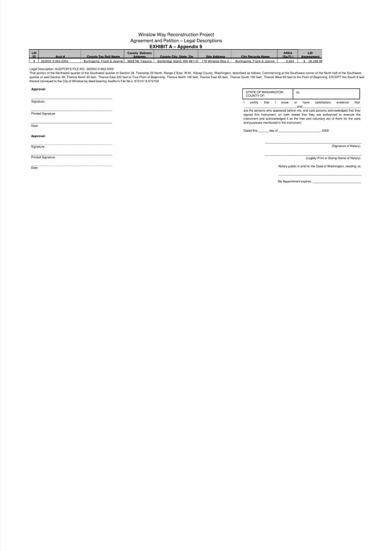
EXHIBIT A – Appendix 9
LIDID Acct # County Tax Roll Name
County DeliveryAddress County City, State, Zip Site Address City Records Name
AREA(Sq.Ft.)
LIDAssessment
9 262502-3-063-2003 Burlingame, Frank & Joanne 9658 NE Yaquina Bainbridge Island, WA 98110 176 Winslow Way E Burlingame, Frank & Joanne 5,663 $ 26,298.95
Legal Description: AUDITOR’S FILE NO. 262502-3-063-2003That portion of the Northwest quarter of the Southwest quarter of Section 26, Township 25 North, Range 2 East, W.M., Kitsap County, Washington, described as follows: Commencing at the Southwest corner of the North half
quarter of said Section 26; Thence North 20 feet; Thence East 220 feet to True Point of Beginning; Thence North 100 feet; Thence East 65 feet; Thence South 100 feet; Thence West 65 feet to the Point of Beginning. EXCE
thereof conveyed to the City of Winslow by deed bearing Auditor's File No’s. 672147 & 672159
Approval:
_______________________________________________
Signature
_______________________________________________
Printed Signature
_______________________________________________
Date
_________________________________________
(S
_________________________________________
(Legibly Print or Stam
Notary public in and for the State of Wash
_________________________________
My Appointment expires: _____________
STATE OF WASHINGTONCOUNTY OF:
ss.
I certify that I know or have satisfactory
_______________________________and____________________
are the persons who appeared before me, and said persons ackno
signed this instrument, on oath stated that they are authorize
instrument and acknowledged it as the free and voluntary act of
and purposes mentioned in the instrument.
Dated this ______ day of ________________________, 2009.
Approval:
_______________________________________________ Signature
_______________________________________________ Printed Signature
_______________________________________________ Date
8/14/2019 Winslow Way Assessments
http://slidepdf.com/reader/full/winslow-way-assessments 17/26
Winslow Way Reconstruction Project
Agreement and Petition – Legal Descriptions
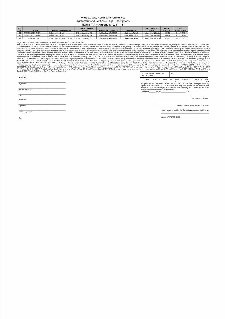
EXHIBIT A – Appendix 10, 11, 13
LIDID Acct # County Tax Roll Name
County DeliveryAddress County City, State, Zip Site Address
City RecordsName
AREA(Sq.Ft.)
LIDAssessment
10 262502-3-069-2007 Miller, Earl & Linda 205 Ludlow Bay Rd Port Ludlow, WA 98365 156 Winslow Way E Miller, Earl & Linda 19,166 $ 47,268.11
11 262502-3-072-2002 Miller, Earl & Linda 205 Ludlow Bay Rd Port Ludlow, WA 98365 106 Madison Ave N Miller, Earl & Linda 13,939 $ 51,477.94
13 262502-3-024-2001 East Winslow Property, LLC 205 Ludlow Bay Rd Port Ludlow, WA 98365 119 Winslow Way E Miller, Earl & Linda 8,712 $ 47,228.11
Legal Descriptions for: 262502-3-069-2007, 262502-3-072-2002, 262502-3-024-2001AUDITOR’S FILE NO. 262502-3-069-2007 Parcel I: That portion of the Northwest quarter of the Southwest quarter, Section 26, Township 25 North, Range 2 East, W.M., described as follows: Beginning at a point 20 feet Northof the Southwest corner of the Northwest quarter of the Southwest quarter of said Section; Thence East 120 feet to the True Point of Beginning; Thence North 217.60 feet; Thence East 80 feet; Thence North 92 feet, more or lfeet North of the South line of the above referred to subdivision; Thence East 11 feet; Thence South 310 feet; Thence West 91 feet, more or less, to the True Point of Beginning; EXCEPT all roads, including any portion conveWinslow; AND EXCEPT, that portion conveyed to Frank H. Burlingame and Joanne C. Burlingame, husband and wife, by instrument recorded under Auditor's File No. 8505240070; Parcel II: An easement for ingress, egresunder and across the following parcel of land, located in Kitsap County, Washington, to wit: That portion of the Northwest quarter of the Southwest quarter of Section 26, Township 25 North, Range 2 East, W.M., described as 9.00 feet of the following described property: Beginning at a point which is 238 feet North and 30 feet East of the Southwest corner of said subdivision; Thence East, a distance of 190 feet; Thence North a distance of 92 feedistance of 190 feet; Thence South, a distance of 92 feet to the True Point of Beginning. AUDITOR’S FILE NO. 262502-3-072-2002 That portion of the Northwest quarter of the Southwest quarter of Section 26, Township 2East, W.M., in Kitsap County, Washington, described as follows: Beginning at the Southwest corner of the North half of the Southwest quarter of said Section 26;Thence North 20 feet; Thence East 20 feet to the True Point of North 115 feet; Thence East 120 feet; Thence South 115 feet; Thence West 120 feet to the True Point of Beginning; EXCEPT that portion, if any, lying within Madison Avenue North; AND EXCEPT that portion, if any, lying withEast. AUDITOR’S FILE NO. 262502-3-024-2001 Lot B of City of Winslow Short Plat recorded under Auditor's File No. 8112160057, being described as follows:That portion Government Lot 4, Section 26, Township 25 North, Rain Kitsap County, Washington, described as follows: Commencing at the Northwest corner of said Government Lot 4, a concrete monument;Thence along the West line of said Government Lot 4 South 0°29'15” East 200 f89°28'55” East along the centerline of a 20 foot vacated alley 130.42 feet to the True Point of Beginning; Thence continuing North 89°28'55”East, along said centerline of a 20 foot vacated alley, 14.58 feet;Thence North 0°2feet:Thence South 89°28'55” West along the South right of way of Winslow Way 90.48 feet;Thence South 0°50' 18” East, more or less, on a common line between butting buildings 92.74 feet;Thence North 89°28'55”East South 0°40'00” East 67.26 feet to the True Point of Beginning.
Approval:
_______________________________________________ Signature
_______________________________________________ Printed Signature
_______________________________________________ Date
STATE OF WASHINGTONCOUNTY OF:
ss.
I certify that I know or have satisfactory __________________________________and________________the persons who appeared before me, and said persons acknosigned this instrument, on oath stated that they are authorizeinstrument and acknowledged it as the free and voluntary act of and purposes mentioned in the instrument.Dated this ______ day of ________________________, 2009.
_________________________________________
(S
_________________________________________
(Legibly Print or Stam
Notary public in and for the State of Wash
_________________________________
My Appointment expires: ______________
Approval:
_______________________________________________ Signature
_______________________________________________ Printed Signature
_______________________________________________ Date
8/14/2019 Winslow Way Assessments
http://slidepdf.com/reader/full/winslow-way-assessments 18/26
Winslow Way Reconstruction Project
Agreement and Petition – Legal Descriptions
EXHIBIT A – Appendix 12
LIDID Acct # County Tax Roll Name County Delivery Address County City, State, Zip Site Address
CityRecords
Name
AREA(Sq.Ft.
)
LIDAssessme
nt
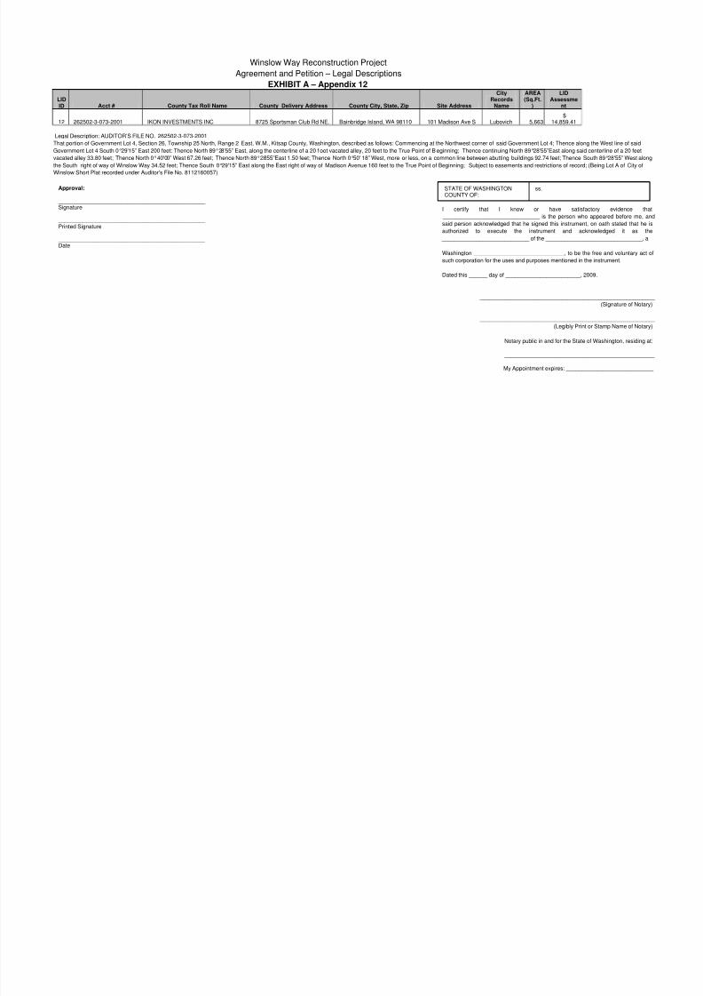
12 262502-3-073-2001 IKON INVESTMENTS INC 8725 Sportsman Club Rd NE. Bainbridge Island, WA 98110 101 Madison Ave S Lubovich 5,663$
14,859.41
Legal Description: AUDITOR’S FILE NO. 262502-3-073-2001
That portion of Government Lot 4, Section 26, Township 25 North, Range 2 East, W.M., Kitsap County, Washington, described as follows: Commencing at the Northwest corner of said Government Lot 4; Thence along the Wes
Government Lot 4 South 0°29'15” East 200 feet; Thence North 89°28'55” East, along the centerline of a 20 f oot vacated alley, 20 feet to the True Point of B eginning; Thence continuing North 89°28'55”East along said centerline
vacated alley 33.80 feet; Thence North 0°40'00” West 67.26 feet; Thence North 89°28'55”East 1.50 feet; Thence North 0°50' 18” West, more or less, on a common line between abutting buildings 92.74 feet; Thence South 89°2
the South right of way of Winslow Way 34.52 feet; Thence South 0°29'15” East along the East right of way of Madison Avenue 160 feet to the True Point of Beginning; Subject to easements and restrictions of record; (Being Lo
Winslow Short Plat recorded under Auditor's File No. 8112160057)
Approval:
_______________________________________________ Signature
_______________________________________________ Printed Signature
_______________________________________________ Date
STATE OF WASHINGTONCOUNTY OF:
ss.
I certify that I know or have satisfactory
_______________________________ is the person who appea
said person acknowledged that he signed this instrument, on oat
authorized to execute the instrument and acknowled
____________________________ of the ____________________
Washington _____________________________, to be the free a
such corporation for the uses and purposes mentioned in the instru
Dated this ______ day of ________________________, 2009.
_________________________________________
(S
_________________________________________
(Legibly Print or Stam
Notary public in and for the State of Wash
_________________________________
My Appointment expires: _____________
8/14/2019 Winslow Way Assessments
http://slidepdf.com/reader/full/winslow-way-assessments 19/26
Winslow Way Reconstruction Project
Agreement and Petition – Legal Descriptions
EXHIBIT A – Appendix 14, 15
LIDID Acct # County Tax Roll Name
County DeliveryAddress
County City, State,Zip Site Address City Records Name
AREA(Sq.Ft.) LID Assessment
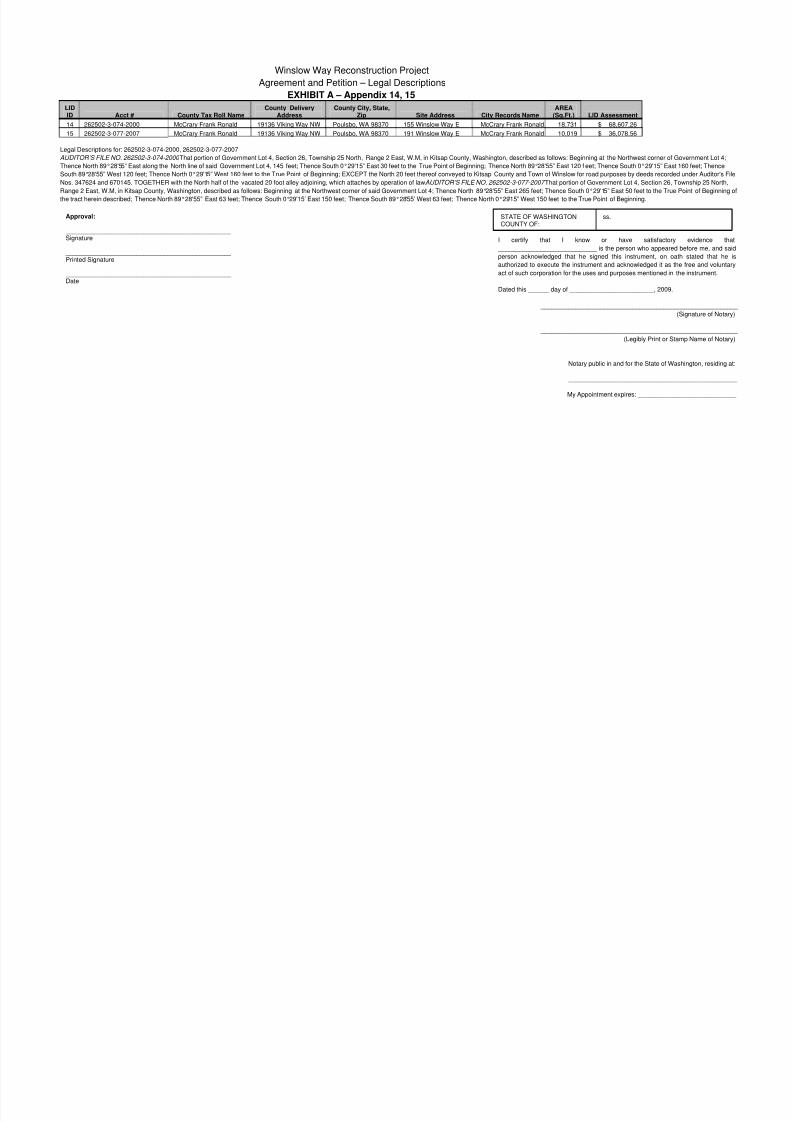
14 262502-3-074-2000 McCrary Frank Ronald 19136 Viking Way NW Poulsbo, WA 98370 155 Winslow Way E McCrary Frank Ronald 18,731 $ 68,607.26
15 262502-3-077-2007 McCrary Frank Ronald 19136 Viking Way NW Poulsbo, WA 98370 191 Winslow Way E McCrary Frank Ronald 10,019 $ 36,078.56
Legal Descriptions for: 262502-3-074-2000, 262502-3-077-2007
AUDITOR’S FILE NO. 262502-3-074-2000 That portion of Government Lot 4, Section 26, Township 25 North, Range 2 East, W.M, in Kitsap County, Washington, described as follows: Beginning at the Northwest corner of Gove
Thence North 89°28'55” East along the North line of said Government Lot 4, 145 feet; Thence South 0°29'15” East 30 feet to the True Point of Beginning; Thence North 89°28'55” East 120 f eet; Thence South 0°29'15” East 160
South 89°28'55” West 120 feet; Thence North 0°29'15” West 160 feet to the True Point of Beginning; EXCEPT the North 20 feet thereof conveyed to Kitsap County and Town of Winslow for road purposes by deeds recorded un
Nos. 347624 and 670145. TOGETHER with the North half of the vacated 20 foot alley adjoining, which attaches by operation of law. AUDITOR’S FILE NO. 262502-3-077-2007 That portion of Government Lot 4, Section 26, Tow
Range 2 East, W.M, in Kitsap County, Washington, described as follows: Beginning at the Northwest corner of said Government Lot 4; Thence North 89°28'55” East 265 feet; Thence South 0°29'15” East 50 feet to the True Poi
the tract herein described; Thence North 89°28'55” East 63 feet; Thence South 0°29'15’ East 150 feet; Thence South 89°28'55’ West 63 feet; Thence North 0°29'15” West 150 feet to the True Point of Beginning.
Approval:
_______________________________________________ Signature
_______________________________________________ Printed Signature
_______________________________________________
Date
STATE OF WASHINGTONCOUNTY OF:
ss.
I certify that I know or have satisfactory
____________________________ is the person who appeared b
person acknowledged that he signed this instrument, on oath
authorized to execute the instrument and acknowledged it as the
act of such corporation for the uses and purposes mentioned in the
Dated this ______ day of ________________________, 2009.
_________________________________________
(S
_________________________________________
(Legibly Print or Stam
Notary public in and for the State of Wash
_________________________________
My Appointment expires: _____________
8/14/2019 Winslow Way Assessments
http://slidepdf.com/reader/full/winslow-way-assessments 20/26
Winslow Way Reconstruction Project
Agreement and Petition – Legal Descriptions
EXHIBIT A – Appendix 16
LIDID Acct # County Tax Roll Name
CountyDeliveryAddress County City, State, Zip Site Address City Records Name
AREA(Sq.Ft.)
LIDAssessment
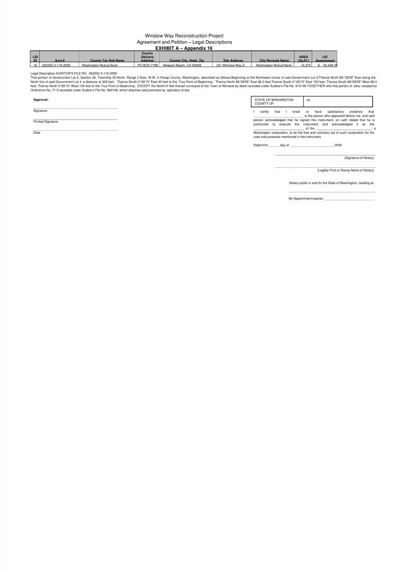
16 262502-3-116-2000 Washington Mutual Bank PO BOX 7788 Newport Beach, CA 92658 231 Winslow Way E Washington Mutual Bank 14,375 $ 43,448.26
Legal Description AUDITOR’S FILE NO. 262502-3-116-2000That portion of Government Lot 4, Section 26, Township 25 North, Range 2 East, W.M, in Kitsap County, Washington, described as follows:Beginning at the Northwest corner of said Government Lot 4;Thence North 89°28'5
North line of said Government Lot 4 a distance of 328 feet; Thence South 0°28'15” East 40 feet to the True Point of Beginning; Thence North 89°28'55” East 96.3 feet;Thence South 0°29'15” East 150 feet; Thence South 89
feet; Thence North 0°29'15” West 150 feet to the True Point of Beginning; EXCEPT the North10 feet thereof conveyed to the Town of Winslow by deed recorded under Auditor's File No. 672146 TOGETHER with that portion
Ordinance No. 71-5 recorded under Auditor's File No. 992108, which attaches said premises by operation of law.
Approval:
_______________________________________________ Signature
_______________________________________________ Printed Signature
_______________________________________________ Date
STATE OF WASHINGTONCOUNTY OF:
ss.
I certify that I know or have satisfactory
____________________________ is the person who appeared b
person acknowledged that he signed this instrument, on oath
authorized to execute the instrument and acknowled
____________________________ of the __________________
Washington corporation, to be the free and voluntary act of such
uses and purposes mentioned in the instrument.
Dated this ______ day of ________________________, 2009.
_________________________________________
(S
_________________________________________
(Legibly Print or Stam
Notary public in and for the State of Wash
_________________________________
My Appointment expires: _____________
8/14/2019 Winslow Way Assessments
http://slidepdf.com/reader/full/winslow-way-assessments 21/26
Winslow Way Reconstruction Project
Agreement and Petition – Legal Descriptions
EXHIBIT A – Appendix 17
LIDID Acct # County Tax Roll Name
County DeliveryAddress County City, State, Zip Site Address
CityRecords
NameAREA
(Sq.Ft.) LID Assessment
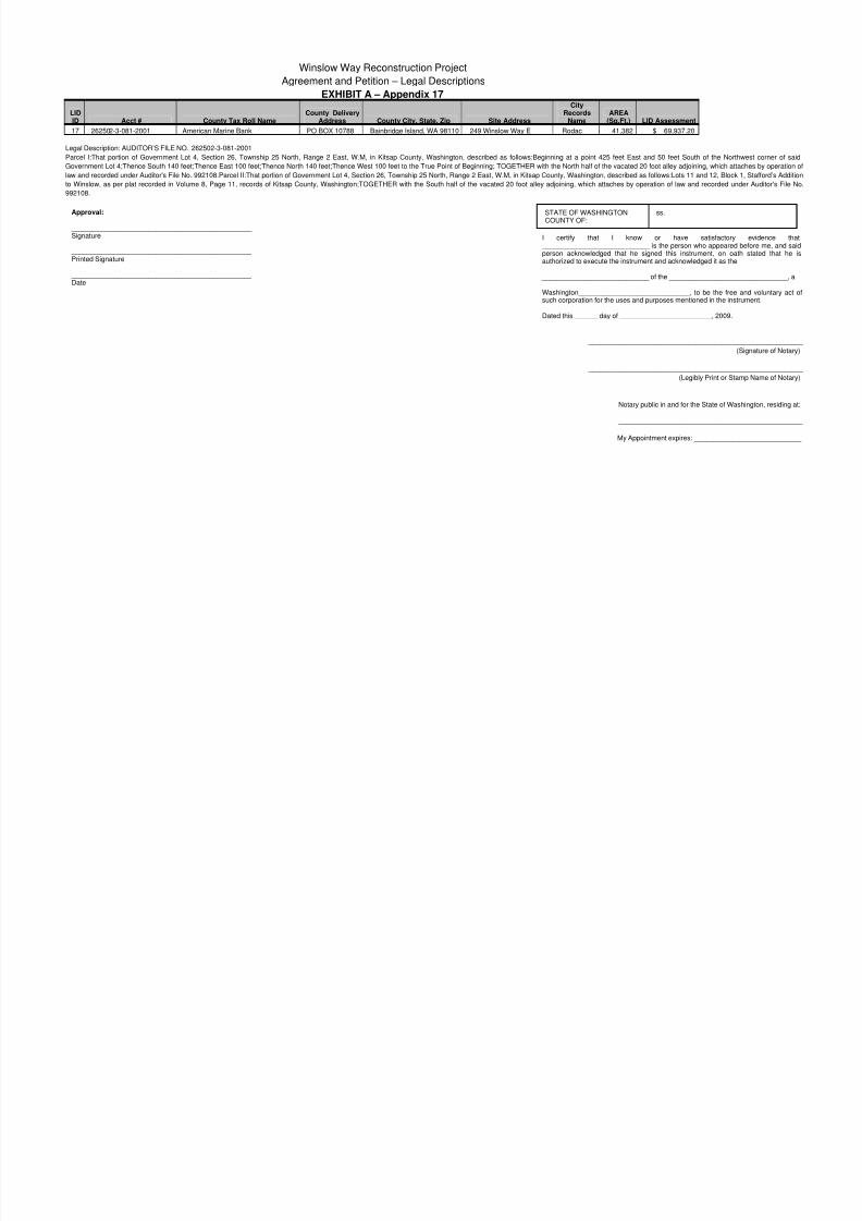
17 262502-3-081-2001 American Marine Bank PO BOX 10788 Bainbridge Island, WA 98110 249 Winslow Way E Rodac 41,382 $ 69,937.20
Legal Description: AUDITOR’S FILE NO. 262502-3-081-2001
Parcel I:That portion of Government Lot 4, Section 26, Township 25 North, Range 2 East, W.M, in Kitsap County, Washington, described as follows:Beginning at a point 425 feet East and 50 feet South of the NorthweGovernment Lot 4;Thence South 140 feet;Thence East 100 feet;Thence North 140 feet;Thence West 100 feet to the True Point of Beginning; TOGETHER with the North half of the vacated 20 foot alley adjoining, which attach
law and recorded under Auditor's File No. 992108.Parcel II:That portion of Government Lot 4, Section 26, Township 25 North, Range 2 East, W.M, in Kitsap County, Washington, described as follows:Lots 11 and 12, Block 1, S
to Winslow, as per plat recorded in Volume 8, Page 11, records of Kitsap County, Washington;TOGETHER with the South half of the vacated 20 foot alley adjoining, which attaches by operation of law and recorded under
992108.
Approval:
_______________________________________________ Signature
_______________________________________________ Printed Signature
_______________________________________________ Date
STATE OF WASHINGTONCOUNTY OF:
ss.
I certify that I know or have satisfactory ____________________________ is the person who appeared bperson acknowledged that he signed this instrument, on oathauthorized to execute the instrument and acknowledged it as the
____________________________ of the ____________________
Washington_____________________________, to be the free asuch corporation for the uses and purposes mentioned in the instru
Dated this ______ day of ________________________, 2009.
_________________________________________
(S
_________________________________________
(Legibly Print or Stam
Notary public in and for the State of Wash
_________________________________
My Appointment expires: _____________
8/14/2019 Winslow Way Assessments
http://slidepdf.com/reader/full/winslow-way-assessments 22/26
Winslow Way Reconstruction Project
Agreement and Petition – Legal Descriptions
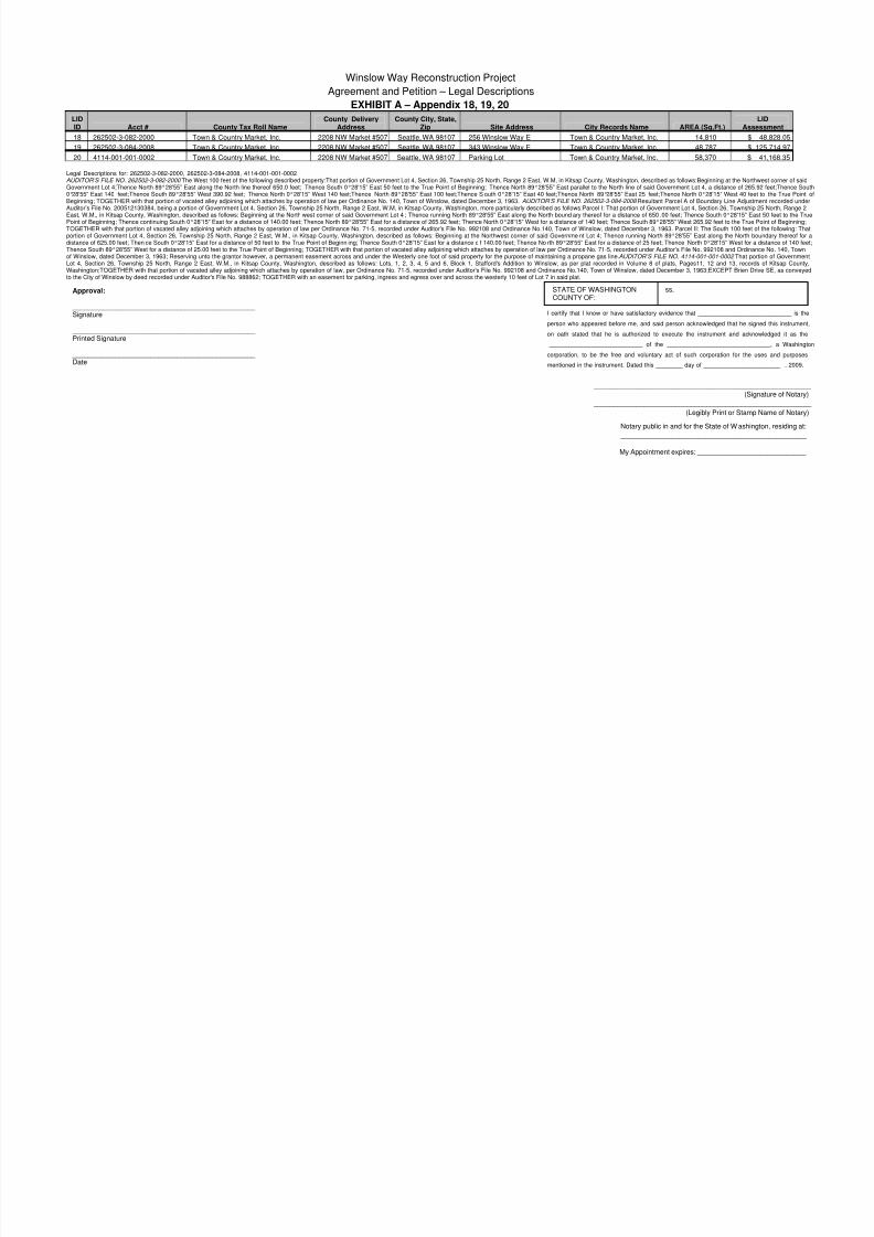
EXHIBIT A – Appendix 18, 19, 20
LIDID Acct # County Tax Roll Name
County DeliveryAddress
County City, State,Zip Site Address City Records Name AREA (Sq.Ft.) As
18 262502-3-082-2000 Town & Country Market, Inc. 2208 NW Market #507 Seattle, WA 98107 256 Winslow Way E Town & Country Market, Inc. 14,810 $
19 262502-3-084-2008 Town & Country Market, Inc. 2208 NW Market #507 Seattle, WA 98107 343 Winslow Way E Town & Country Market, Inc. 48,787 $
20 4114-001-001-0002 Town & Country Market, Inc. 2208 NW Market #507 Seattle, WA 98107 Parking Lot Town & Country Market, Inc. 58,370 $
Legal Descriptions for: 262502-3-082-2000, 262502-3-084-2008, 4114-001-001-0002AUDITOR’S FILE NO. 262502-3-082-2000 The West 100 feet of the following described property:That portion of Government Lot 4, Section 26, Township 25 North, Range 2 East, W.M, in Kitsap County, Washington, described as follows:Beginning at the NortGovernment Lot 4;Thence North 89°28'55” East along the North line thereof 650.0 feet; Thence South 0°28'15” East 50 feet to the True Point of Beginning; Thence North 89°28'55” East parallel to the North line of said Government Lot 4, a distance of 265.0°28'55” East 140 feet;Thence South 89°28'55” West 390.92 feet; Thence North 0°28'15” West 140 feet;Thence North 89°28'55” East 100 feet;Thence S outh 0°28'15” East 40 feet;Thence North 89°28'55” East 25 feet;Thence North 0°28'15” West 40 feeBeginning; TOGETHER with that portion of vacated alley adjoining which attaches by operation of law per Ordinance No. 140, Town of Winslow, dated December 3, 1963. AUDITOR’S FILE NO. 262502-3-084-2008 Resultant Parcel A of Boundary Line AdjusAuditor’s File No. 200512130384, being a portion of Government Lot 4, Section 26, Township 25 North, Range 2 East, W.M, in Kitsap County, Washington, more particularly described as follows:Parcel I: That portion of Government Lot 4, Section 26, TownshipEast, W.M., in Kitsap County, Washington, described as follows: Beginning at the North west corner of said Government Lot 4 ; Thence running North 89°28'55” East along the North bound ary thereof for a distance of 650 .00 feet; Thence South 0°28'15” EaPoint of Beginning; Thence continuing South 0°28'15” East for a distance of 140.00 feet; Thence North 89°28'55” East for a distance of 265.92 feet; Thence North 0°28'15” West for a distance of 140 feet; Thence South 89°28'55” West 265.92 feet to the True TOGETHER with that portion of vacated alley adjoining which attaches by operation of law per Ordinance No. 71-5, recorded under Auditor's File No. 992108 and Ordinance No.140, Town of Winslow, dated December 3, 1963. Parcel II: The South 100 feet oportion of Government Lot 4, Section 26, Township 25 North, Range 2 East, W.M., in Kitsap County, Washington, described as follows: Beginning at the Northwest corner of said Governme nt Lot 4; Thence running North 89°28'55” East along the North bdistance of 625.00 feet; Then ce South 0°28'15” East for a distance of 50 feet to the True Point of Beginn ing; Thence South 0°28'15” East for a distance o f 140.00 feet; Thence No rth 89°28'55” East for a distance of 25 feet; Thence North 0°28'15” West for aThence South 89°28'55” West for a distance of 25.00 feet to the True Point of Beginning; TOGETHER with that portion of vacated alley adjoining which attaches by operation of law per Ordinance No. 71-5, recorded under Auditor’s File No. 992108 and Ordinanof Winslow, dated December 3, 1963; Reserving unto the grantor however, a permanent easement across and under the Westerly one foot of said property for the purpose of maintaining a propane gas line. AUDITOR’S FILE NO. 4114-001-001-0002 That pLot 4, Section 26, Township 25 North, Range 2 East, W.M., in Kitsap County, Washington, described as follows: Lots, 1, 2, 3, 4, 5 and 6, Block 1, Stafford's Addition to Winslow, as per plat recorded in Volume 8 of plats, Pages11, 12 and 13, recorWashington;TOGETHER with that portion of vacated alley adjoining which attaches by operation of law, per Ordinance No. 71-5, recorded under Auditor's File No. 992108 and Ordinance No.140, Town of Winslow, dated December 3, 1963;EXCEPT Brien Dto the City of Winslow by deed recorded under Auditor's File No. 988862; TOGETHER with an easement for parking, ingress and egress over and across the westerly 10 feet of Lot 7 in said plat.
Approval:
_______________________________________________ Signature
_______________________________________________ Printed Signature
_______________________________________________ Date
STATE OF WASHINGTONCOUNTY OF:
ss.
I certify that I know or have satisfactory evidence that _________________
person who appeared before me, and said person acknowledged that he si
on oath stated that he is authorized to execute the instrument and ack
____________________________ of the ___________________________
corporation, to be the free and voluntary act of such corporation for the
mentioned in the instrument. Dated this ________ day of _______________
_________________________________________
(S
_________________________________________
(Legibly Print or Stam
Notary public in and for the State of W ashin
__________________________________
My Appointment expires: _______________
8/14/2019 Winslow Way Assessments
http://slidepdf.com/reader/full/winslow-way-assessments 23/26
Winslow Way Reconstruction Project
Agreement and Petition – Legal Descriptions
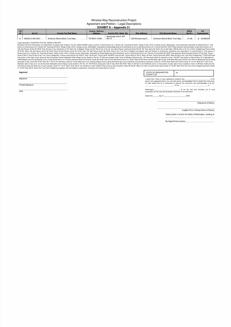
EXHIBIT A – Appendix 21
LIDID Acct # County Tax Roll Name
County DeliveryAddress County City, State, Zip Site Address City Records Name
AREA(Sq.Ft.) A
21 262502-3-085-2007 American Marine Bank Trust Dept. PO BOX 10788Bainbridge Island, WA98110 393 Winslow way E American Marine Bank Trust Dept. 9,148 $
Legal Description: AUDITOR’S FILE NO. 262502-3-085-2007Resultant Parcel B of Boundary Line Adjustment recorded under Auditor’s File No. 200512130384, being a portion of Government Lot 4, Section 26, Township 25 North, Range 2 East, W.M, in Kitsap County, Washington, more particularly described as fo
portion of Government Lot 4, Section 26, Township 25 North, Range 2 East, W.M, in Kitsap County, Washington, described as follows:Beginning at the Northwest corner of said Government Lot 4;Thence South 00°32’40” West along the west boundary of said
190 feet;Thence South 80°29’30” East 20 feet to the intersection of the East line of Madison Street and the North line of the 20 foot alley;Thence continuing South 89°29” 30” East along the North line of said alley 1005.92 feet to the Tru e Point of Be
00°32’40” West 140 feet;Thence Nor th 89°29’30” West 50 feet;Thence South 00°32’40” East 140 feet;Thence South 89°29’30” East to the True Point of Beginni ng.Together with and Subje ct to easements, restrictions and reservations of record.Parc
Government Lot 4, Section 26, Township 25 North, Range 2 East, W.M, in Kitsap County, Washington, described as follows:Beginning at the Northwest corner of said Government Lot 4;Thence running North 89°28'55” East along the North boundary thereof, 9
South 0°28'15” East 50 feet to the True Point of Beginning; Thence continuing So uth 0°28'15” East 140.00 feet; Thence North 89°28'55” East 60 feet; Thence North 0°28'15” West 140 feet; Thence South 89°28'55” West 60 feet to the True Point of Beginni
that portion of the right of way along the South boundary thereof dedicated under Kitsap County Auditor’s File No. 571404 and vacated under Town of Winslow Ordinance No. 140 that would attach by operation of law. EXCEPT that portion of Government
follows:Beginning at the Northwest corner of said Government Lot 4;Thence along the North line thereof, South 88°40’48” East 915.92 feet;Thence South 01°20’42” West 50.00 feet to the Northerly right of way of Winslow Way East and the True Point of Be
said right of way, South 88°40’48” East 45.17 feet to the Northerly extension of the West face of an existing building;Thence along said West face and its Northerly and Southerly extensions, South 01°23’48” West 59.84 feet;Thence South 01°21’18” Wes
Northerly right of way of an unn amed street dedicated und er Kitsap County Auditor’s File No. 571 404;Thence along said r ight of way North 88°40’48” West 41.49 feet to the Northeast corne r of that portion of said r ight of way vacated by Town of Wi
140;Thence along the West line of said vacation, South 01°19’12” West 10.00 feet to the centerline of said vacation;Thence alon g said centerline, North 88°40’48” West 3.61 feet to a point which bears South 01°20’42” West from the True Point of Be
01°20’42” East 150.01 feet to the True Point of Beginning.Together with and Subject to easements, restrictions and reservations of record.
Approval:
_______________________________________________ Signature
_______________________________________________ Printed Signature
_______________________________________________ Date
STATE OF WASHINGTONCOUNTY OF:
ss.
I certify that I know or have satisfactory evidence that ________________
person who appeared before me, and said person acknowledged that he s
on oath stated that he is authorized to execute the instrument and ack
________________________________ of the _______________________
Washington_____________________________, to be the free and vo
corporation for the uses and purposes mentioned in the instrument.
Dated this ______ day of ________________________, 2009.
_________________________________________
(S
_________________________________________
(Legibly Print or Stam
Notary public in and for the State of Wash
_________________________________
My Appointment expires: _____________
8/14/2019 Winslow Way Assessments
http://slidepdf.com/reader/full/winslow-way-assessments 24/26
Winslow Way Reconstruction Project
Agreement and Petition – Legal Descriptions
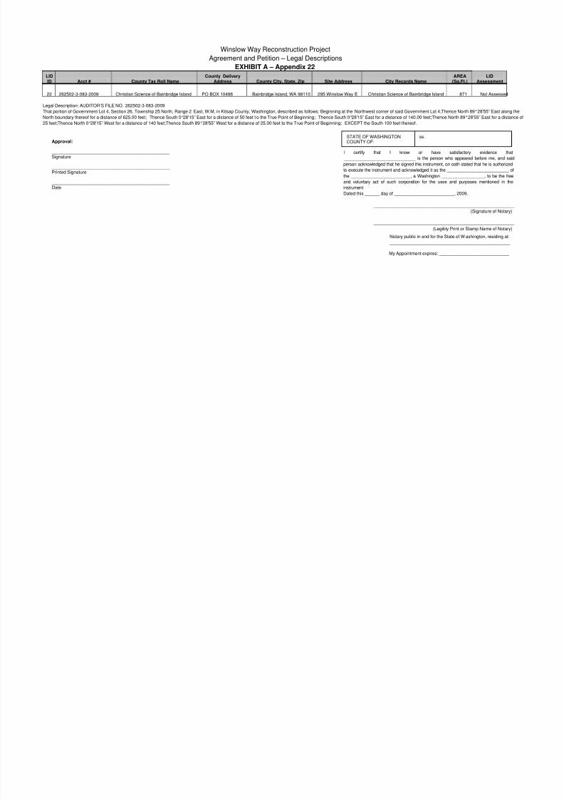
EXHIBIT A – Appendix 22
LIDID Acct # County Tax Roll Name
County DeliveryAddress County City, State, Zip Site Address City Records Name
AREA(Sq.Ft.) Ass
22 262502-3-083-2009 Christian Science of Bainbridge Island PO BOX 10488 Bainbridge Island, WA 98110 295 Winslow Way E Christian Science of Bainbridge Island 871 Not
Legal Description: AUDITOR’S FILE NO. 262502-3-083-2009
That portion of Government Lot 4, Section 26, Township 25 North, Range 2 East, W.M, in Kitsap County, Washington, described as follows: Beginning at the Northwest corner of said Government Lot 4;Thence North 89°28'55”
North boundary thereof for a distance of 625.00 feet; Thence South 0°28'15” East for a distance of 50 feet t o the True Point of Beginning; Thence South 0°28'15” East for a distance of 140.00 feet;Thence North 89°28'55” East
25 feet;Thence North 0°28'15” West for a distance of 140 feet;Thence South 89°28'55” West for a distance of 25.00 feet to the True Point of Beginning; EXCEPT the South 100 feet thereof.Approval:
_______________________________________________ Signature
_______________________________________________ Printed Signature
_______________________________________________ Date
STATE OF WASHINGTONCOUNTY OF:
ss.
I certify that I know or have satisfactory evid
______________________________ is the person who appeared before
person acknowledged that he signed this instrument, on oath stated that he
to execute the instrument and acknowledged it as the _________________
the _________________________, a Washington __________________,
and voluntary act of such corporation for the uses and purposes men
instrument
Dated this ______ day of ________________________, 2009.
_____________________________________________
(Signat
_____________________________________________
(Legibly Print or Stamp Na
Notary public in and for the State of W ashington,
_______________________________________
My Appointment expires: ___________________
8/14/2019 Winslow Way Assessments
http://slidepdf.com/reader/full/winslow-way-assessments 25/26
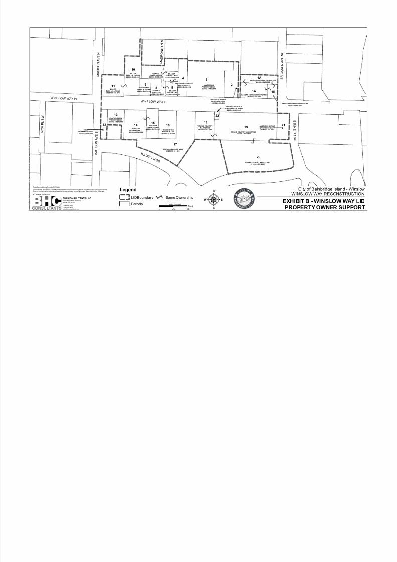
TOWN& COUNTRY MARKET INC4114-001-001-0002
AMERICAN MARINE BANK262502-3-081-2001
TOWN& COUNTRY MARKET INC262502-3-084-2008
SANDSTROMPROPERTIES LLC262502-3-146-2004
HAGGAR SCRIBNER PROPERTIES262502-3-049-2002
MCCRARYFRANK RONALD262502-3-074-2000
BRANDTJAMES & LINDA
262502-3-058-2000
MILLEREARL L & LINDAA262502-3-072-2002
MILLEREARL L & LINDAA262502-3-069-2007
WASHINGTONMUTUAL BANK
262502-3-116-2000
TOWN& COUNTRYMARKET INC
262502-3-082-2000
MCCRARYFRANK RONALD
262502-3-077-2007
HAGGAR SCRIBNERPROPERTIES, LLC262502-3-054-2004
WINSLOW HARDWARE&MERCANTILE
262502-3-056-2002
EAST WINSLOWPROPERTIES LLC262502-3-024-2001
ROBERTSJEWELERY
262502-3-062-2004
AMERICAN MARINEBANKTRUST DEPT262502-3-085-2007IKON
INVESTMENTS INC262502-3-073-2001
BRANDTJAMES & LINDA
262502-3-060-2006
BURLINGAMEFRANK & JOANNE262502-3-063-2003
BRANDTJAMES & LINDA
262502-3-059-2009
CHRISTIAN SCIENCEOF BAINBRIDGE ISLAND
262502-3-083-2009
HAGGAR SCRIBNER PROPERTIES262502-3-050-2008
HAGGAR SCRIBNER PROPERTIES262502-3-048-2003
3
20
19
1B
17
6
2
10
14
4
1816
119
15
58
21
13
7
12
22
1A
1C
W INSLOW W AY E
B J UNE
D R
S E
M A D I S O N
A V E S
M A
D I S O N A V E N
E R I C
K S E N
A V E
N E
F I N C H P L S W
M A D R O N E L N
N
W INSLOW W AY W
B J U N E D R S E
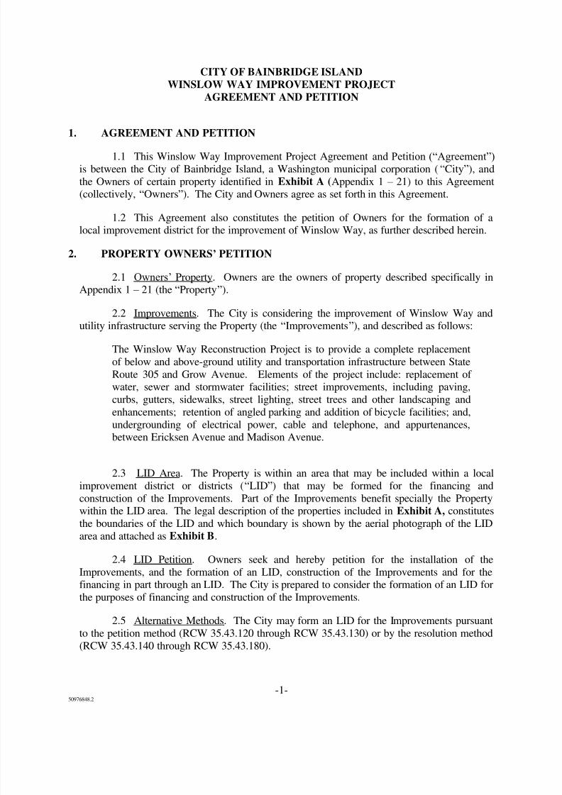
City of Bainbridge IslanWINSLOW WAY RECONS
EXHIBIT B - WINSLOW
PROPERTY OWNER S:0 15075Feet
BHC CONSULTANTS LLC1601Fifth Avenue,Suite500Seattle,WA 98101
T206/505-3400F206/505-3406www.bhcconsultants.com
P : \ M a p p i n g \ M a p s_
G e n e r a t e d \ W i n s l o w \ 0 7 - 1 0 1 0 9 . 0
0 \ m a p s \ E x h i b i t B - W i n s l o w W a y L I D 1 1 x 1 7 - L e g a l . m x d
DataSource:KitsapCountyGIS2009.Thismapisa geographicrepresentationbasedoninformationavailable.It doesnotrepresentsurveydata.Nowarrantyis madeconcerningtheaccuracy,currency,or completenessof datadepictedon thismap.
MAPDATE:JUNE2009
1inch= 150feet
Legend
LIDBoundary
Parcels
Same Ownership
!
!
!
!
8/14/2019 Winslow Way Assessments
http://slidepdf.com/reader/full/winslow-way-assessments 26/26
LID
ID Acct #
County Tax Roll
Name
County
Delivery Address
County
City, State, Z ip Site Address
City Records
Name
AREA
(Sq.Ft.)
Area
(Acre)
Front
(ft)
Side
(ft)
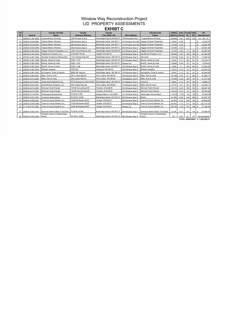
1 262502-3-160-2005 V irgi ni a Mason Winslow 380 Winslow Way E Bainb ri dge I sl and, WA 98110 380 Winslow Way E V irgi ni a Mason Winslow 24,829 0.57 200 125
1A 262502-3-049-2002 Virginia Mason Winslow 380 Winslow Way E Bainbridge Island, WA 98111 141 Ericksen Ave NE Haggar Scribner Properties 3,920 0.091B 262502-3-048-2003 Virginia Mason Winslow 380 Winslow Way E Bainbridge Island, WA 98111 143 Ericksen Ave NE Haggar Scribner Properties 10,454 0.24
1C 262502-3-050-2008 Virginia Mason Winslow 380 Winslow Way E Bainbridge Island, WA 98111 380 Winslow Way E Haggar Scribner Properties 10,454 0.24
2 262502-3-054-2004 Haggar Scribner Properties, LLC 3091 Point White Dr. NE Bainbridge Island, WA 98110 310 Winslow Way E Haggar Scribner Properties 12,197 0.28 74 192
3 262502-3-146-2004 Sandstrom Property, LLC 5725 NE 77th St. Seatt le , WA 98115 278 Winslow Way E Sandstrom Property, LLC 39,640 0.91 196 192
4 262502-3-056-2002 Winslow Hardware & Mercant ile 1237 Hawley Way NE Bainbridge Is land, WA 98110 240 Winslow Way E Schuricht 10,019 0.23 50 202
5 262502-3-060-2006 Brandt, James & Linda POB 11187 Bainbridge Island, WA 98110 210 Winslow Way E Brandt, James & Linda 4,792 0.11 65 80
6 262502-3-058-2000 Brandt, James & Linda POB 11187 Bainbridge Island, WA 98110 Parking Lot Brandt, James & Linda 15,682 0.36 75 54
7 262502-3-059-2009 Brandt, James & Linda POB 11188 Bainbridge Island, WA 98111 150 Winslow Way E Brandt, James & Linda 4,356 0.1 196 403
8 262502-3-062-2004 Roberts Jewelery POB 345 Indianola, WA 98342 194 Winslow Way E Roberts Jewelery 5,227 0.12 52 92
9 262502-3-063-2003 Burlingame, Frank & Joanne 9658 NE Yaquina Bainbridge Island, WA 98110 176 Winslow Way E Burlingame, Frank & Joanne 5,663 0.13 62 92
10 262502-3-069-2007 Miller, Earl & Linda 205 Ludlow Bay Rd Port Ludlow, WA 98365 156 Winslow Way E Miller, Earl & Linda 19,166 0.44 81 302
11 262502-3-072-2002 Miller, Earl & Linda 205 Ludlow Bay Rd Port Ludlow, WA 98365 106 Madison Ave N Miller, Earl & Linda 13,939 0.32 120 115
12 262502-3-073-2001 IKON INVESTMENTS INC 8725 Sportsman Club Rd NE Bainbridge Island, WA 98110 101 Madison Ave S Lubovich 5,663 0.13 35 160
13 262502-3-024-2001 East Winslow Property, LLC 205 Ludlow Bay Rd Port Ludlow, WA 98365 119 Winslow Way E Miller, Earl & Linda 8,712 0.2 90 160
14 262502-3-074-2000 McCra ry F rank Ronald 19136 V ik ing Way NW Pou lsbo , WA 98370 155 Winslow Way E McCrary Frank Ronald 18,731 0.43 120 160
15 262502-3-077-2007 McCra ry F rank Ronald 19136 V ik ing Way NW Pou lsbo , WA 98370 191 Winslow Way E McCrary Frank Ronald 10,019 0.23 63 160
16 262502-3-116-2000 Washington Mutual Bank PO BOX 7788 Newport Beach, CA 92658 231 Winslow Way E Washington Mutual Bank 14,375 0.33 92 150
17 262502-3-081-2001 American Marine Bank PO BOX 10788 Bainbridge Island, WA 98110 249 Winslow Way E Rodac 41,382 0.95 100 295
18 262502-3-082-2000 Town & Country Market, Inc. 2208 NW Market #507 Seattle, WA 98107 256 Winslow Way E Town & Country Market, Inc. 14,810 0.34 100 150
19 262502-3-084-2008 Town & Country Market, Inc. 2208 NW Market #507 Seattle, WA 98107 343 Winslow Way E Town & Country Market, Inc. 48,787 1.12 311 150
20 4114-001-001-0002 Town & Country Market, Inc. 2208 NW Market #507 Seattle, WA 98107 Parking Lot Town & Country Market, Inc. 58,370 1.34 372 188
21 262502-3-085-2007 Amer ican Mari ne Bank Trus t Dep t. PO BOX 10788 Bainb ri dge I sl and, WA 98110 393 Winslow Way E American Marine Bank Trust Dept. 9,148 0.21 65 140
22 262502-3-083-2009
Christian Science of Bainbridge
Island PO BOX 10488 Bainbridge Island, WA 98110 295 Winslow Way E
Christian Science of Bainbridge
Island 871 0.02 25 40
Winslow Way Reconstruction Project
LID PROPERTY ASSESSMENTS
EXHIBT C
TOTAL ASSESSED


![The Winslow mail. (Winslow, Ariz.) 1926-05-28 [p PAGE FOUR]](https://img.pdfslide.us/doc/110x75/621058d8c7683c59fe60e913/the-winslow-mail-winslow-ariz-1926-05-28-p-page-four.jpg)