Embed Size (px)
Citation preview

Wingellina Nickel Project
Baseline Vegetation and Flora Assessment
April 2009
Outback Ecology Services 1/71 Troy Terrace Jolimont WA 6014 Ph: +61 (08) 9388 8799 Fax: +61 (08) 9388 8633 [email protected]

Wingellina Nickel Project
Baseline Vegetation and Flora Assessment Distribution: Company Copies Contact Name
Metals X Limited 2 copies (plus CD copy) Paul Cmrlec Document Control for Job Number: WMN-VS-0907
Author Reviewer Report Status Signature Date of Issue
Brett Neasham, Belinda Newman David Jasper Draft Interim Report
DJ 4 July 2008
Martin Henson David Jasper Draft report DJ 15 April, 2009 DISCLAIMER, CONFIDENTIALITY AND COPYRIGHT STATEMENT © Outback Ecology. All rights reserved. No part of this work may be reproduced in any material form or communicated by any means without the permission of the copyright owner. This document is confidential. Neither the whole nor any part of this document may be disclosed to any third party without the prior written approval of Outback Ecology and Metals X Limited. Outback Ecology undertook the work, and prepared this document, in accordance with specific instructions from Metals X Limited to whom this document is addressed, within the time and budgetary requirements of Metals X Limited. The conclusions and recommendations stated in this document are based on those instructions and requirements, and they could change if such instructions and requirements change or are in fact inaccurate or incomplete. Outback Ecology has prepared this document using data and information supplied to Outback Ecology by Metals X Limited and other individuals and organizations, most of whom are referred to in this document. Where possible, throughout the document the source of data used has been identified. Unless stated otherwise, Outback Ecology has not verified such data and information. Outback Ecology does not represent such data and information as true or accurate, and disclaims all liability with respect to the use of such data and information. All parties relying on this document, do so entirely at their own risk in the knowledge that the document was prepared using information that Outback Ecology has not verified. This document is intended to be read in its entirety, and sections or parts of the document should therefore not be read and relied on out of context. The conclusions and recommendations contained in this document reflect the professional opinion of Outback Ecology, using the data and information supplied. Outback Ecology has used reasonable care and professional judgment in its interpretation and analysis of the data. The conclusions and recommendations must be considered within the agreed scope of work, and the methodology used to carry out the work, both of which are stated in this document. This document was intended for the sole use of Metals X Limited and only for the use for which it was prepared, which is stated in this document. Any representation in the document is made only to Metals X Limited. Outback Ecology disclaims all liability with respect to the use of this document by any third party, and with respect to the use of and reliance upon this document by any party, including Metals X Limited for a purpose other than the purpose for which it was prepared. Outback Ecology has conducted environmental field monitoring and/or testing for the purposes of preparing this document. The type and extent of monitoring and/or testing is described in the document. On all sites, there exists varying degrees of non-uniformity of the vertical and horizontal soil and water conditions. Because of this non-uniformity, no monitoring, testing or sampling technique can completely eliminate the possibility that the results/samples obtained through monitoring or testing are not entirely representative of the soil and/or groundwater conditions on the site. Any conclusions based on the monitoring and/or testing only serve as an indication of the environmental condition of the site (including the presence or otherwise of contaminants or emissions) at the time of preparing this document. It should be noted that site conditions, including the exact location, extent and concentration of contaminants, can change with time. Subject to the limitations imposed by the instructions and requirements of Metals X Limited, the monitoring and testing have been undertaken in a professional manner, according to generally-accepted practices and with a degree of skill and care which is ordinarily exercised by reputable environmental consultants in similar circumstances. Outback Ecology makes no other warranty, express or implied.

EXECUTIVE SUMMARY
Outback Ecology was commissioned by Metals X Limited to conduct a baseline vegetation and flora
survey of the Wingellina Nickel Project, within exploration tenement E69/535 in Western Australia.
The vegetation and flora survey was one component of a broader study undertaken concurrently by
Outback Ecology, including assessment of terrestrial fauna, subterranean fauna, soils and waste
materials within the project area.
The project area is approximately 8 km south-west of Surveyor Generals Corner, within the Wingellina
Hills, which lie to the north of the Musgrave Ranges in the Ngaanyatjarra Lands Indigenous Protected
Area. The project area lies within the Mann-Musgrave subregion of the Central Ranges bioregion and
is approximately 1400km north-east of Perth.
The vegetation and flora survey was planned and implemented as far as practicable in accordance
with the Environmental Protection Authority (EPA) Position Statement No 3 “Terrestrial Biological
Surveys as an Element of Biodiversity Protection” (EPA, 2002), and Guidance Statement No 51
“Terrestrial Flora and Vegetation Surveys for Environmental Impact Assessment in Western Australia
(EPA, 2004).
The objectives of the flora and vegetation survey were to:
i. Undertake a census and develop an inventory of flora located within the project area. This
incorporated a desktop review of available information and a detailed quadrat-based field
survey;
ii. Define, describe, delineate and map vegetation associations across the survey area;
iii. Undertake a review of significant flora species (including Declared Rare and Priority Flora)
located, or likely to occur, within the survey area;
iv. Provide an initial assessment of the regional and local conservation value of the flora and
vegetation; and
v. Provide quantitative data that will provide a baseline against which future impacts and
rehabilitation can be assessed, and form the basis of a monitoring programme.
A total of 176 specimens were collected during the April 2008 survey of the Wingellina project area, of
which 154 were identified to species level. Of the identified flora, there were 100 taxa (including
subspecies and variants) from 40 genera and 24 families. The flora was dominated by Mimosaceae,
with 17 taxa from 1 genus and Poaceae, with 16 taxa from 11 genera recorded.
No Declared Rare or Priority Flora were recorded during the survey.
No Threatened or Priority Ecological Communities were recorded from the survey area.
One alien taxon, *Cenchrus ciliaris (Buffel grass), was recorded during the survey.
Seven vegetation units were described from this survey of the Wingellina study area. The majority of
these units were composed of Eucalytpus Shrub Mallee which shows variation on the hills in the study
area, however the majority of the vegetation is Acacia aneurq (Mulga) Woodland.
Vegetation condition in the Wingellina area varied from Excellent to Degraded. The main sources of
disturbance were considered to be human activities (including repeated fires) and grazing by feral
camels.
Outback Ecology conducted surveys in the project area in a manner that was sensitive to the
traditional owners. During the field survey, a traditional elder of the Wingellina community
accompanied the field surveyors on several occasions.

Wingellina Nickel Project Baseline Flora and Vegetation Survey
TABLE OF CONTENTS
1.0 INTRODUCTION ......................................................................................................................1
1.1 PROJECT BACKGROUND ...................................................................................................... 1
1.2 SCOPE AND OBJECTIVES OF THE STUDY ............................................................................... 1
2.0 EXISTING ENVIRONMENT......................................................................................................2
2.1 IBRA REGION – CENTRAL RANGES 1 MANN –MUSGRAVE BLOCK SUBREGION .......................... 2
2.2 CLIMATE ............................................................................................................................ 2
3.0 METHODS ................................................................................................................................4
3.1 EPA SURVEY GUIDELINES................................................................................................... 4
3.2 DESKTOP REVIEW .............................................................................................................. 5
3.2.1 Environment Protection and Biodiversity Conservation (EPBC) Act 1999 Protected
Matters Database Search.............................................................................................................5
3.2.2 Declared Rare and Priority Flora – DEC Database Search...........................................6
3.2.3 Threatened Ecological Communities – DEC Database Search ....................................6
3.2.4 Review of Existing Reports ............................................................................................7
3.3 VEGETATION FIELD SURVEY ................................................................................................ 7
3.3.1 Timing of Surveys ..........................................................................................................7
3.3.2 Survey personnel ...........................................................................................................8
3.3.3 Survey Methods .............................................................................................................8
3.4.1 Analysis of Floristic Data................................................................................................9
3.4.2 Vegetation Description ...................................................................................................9
3.4.3. Vegetation Mapping .....................................................................................................10
3.5 LIMITATIONS OF SURVEY ................................................................................................... 10
4.0 RESULTS ...............................................................................................................................11
4.1 DESKTOP REVIEW ............................................................................................................ 11
4.1.1 Environment Protection and Biodiversity Conservation (EPBC) Act 1999 Protected
Matters Database Search...........................................................................................................11
4.1.2 Declared Rare and Priority Flora .................................................................................11
4.1.3 Threatened Ecological Communities ...........................................................................11
4.2 FIELD SURVEY.................................................................................................................. 16
4.2.1 Flora composition.........................................................................................................16
4.2.2 Conservation Significant Flora Species and Vegetation Communities........................17
4.2.3 Introduced Flora ...........................................................................................................17
4.2.4 Data Analysis ...............................................................................................................17
4.2.5 Vegetation Types – Descriptions .................................................................................19
4.2.6 Vegetation Condition Assessment ...............................................................................22
5.0 SUMMARY AND RECOMMENDATIONS........................ ......................................................23
6.0 REFERENCES .......................................................................................................................25

Wingellina Nickel Project Baseline Flora and Vegetation Survey
List of Figures
Figure 1 Location of the Wingellina Project Area............................................................................1
Figure 2 Climate data for the Giles Bureau of Meteorology (BOM) recording station (adapted
from BOM, 2008). ............................................................................................................3
Figure 3 Monthly rainfall received at Giles weather station from April 2007 – April 2008 in
comparison to the long-term mean monthly rainfall. The red line indicates the timing
of survey..........................................................................................................................8
Figure 4 PRIMER dendrogram of relationships between vegetation communities......................... 18
Figure 5 Vegetation map of the Wingellina study area ................................................................. 21
List of Tables
Table 1 Summary of Potential Flora and Vegetation Survey Constraints..................................... 10
Table 2 Summary of Database Results for Flora of Conservation Significance Collected in
the Region Within which the Wingellina Project is Located. ............................................ 12
Table 3 Summary of dominant plant families in the Wingellina study area.................................. 17
Table 4 Vegetation condition assessment of survey sites within the study area.......................... 22
Appendices
Appendix A Definitions of Declared Rare and Priority Flora and Threatened Ecological
Community Classifications
Appendix B Vegetation Condition Scale
Appendix C Classification of Vegetation Structural Formation and Height Classes
Appendix D DEC Database Search Results
Appendix E Environment Protection and Biodiversity Conservation (EPBC) Act 1999 Protected
Matters Database Search
Appendix F Site Vegetation Descriptions and Photographs
Appendix G Site x Species Matrix
Wingellina Nickel Project Baseline Flora and Vegetation Survey
1
1.0 INTRODUCTION
1.1 Project Background
Outback Ecology was commissioned by Metals X Limited to conduct a comprehensive baseline flora
and vegetation survey of the Wingellina Nickel Project, within exploration tenement E69/535 in
Western Australia. The flora and vegetation survey was one component of a broader study
undertaken concurrently by Outback Ecology, including assessment of terrestrial fauna, subterranean
fauna, soils, and waste materials within the project area. The survey was conducted during April
2008.
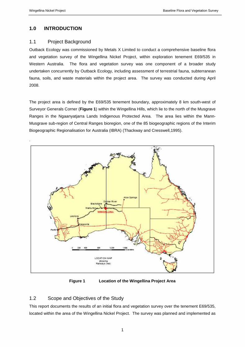
The project area is defined by the E69/535 tenement boundary, approximately 8 km south-west of
Surveyor Generals Corner (Figure 1 ) within the Wingellina Hills, which lie to the north of the Musgrave
Ranges in the Ngaanyatjarra Lands Indigenous Protected Area. The area lies within the Mann-
Musgrave sub-region of Central Ranges bioregion, one of the 85 biogeographic regions of the Interim
Biogeographic Regionalisation for Australia (IBRA) (Thackway and Cresswell,1995).
.
Figure 1 Location of the Wingellina Project Area
1.2 Scope and Objectives of the Study
This report documents the results of an initial flora and vegetation survey over the tenement E69/535,
located within the area of the Wingellina Nickel Project. The survey was planned and implemented as

Wingellina Nickel Project Baseline Flora and Vegetation Survey
2
far as practicable in accordance with the Environmental Protection Authority (EPA) Position Statement
No 3 “Terrestrial Biological Surveys as an Element of Biodiversity Protection” (EPA, 2002), and
Guidance Statement No 51 “Terrestrial Flora and Vegetation Surveys for Environmental Impact
Assessment in Western Australia (EPA, 2004).
The objectives of the flora and vegetation survey were to:
• Undertake a census and develop an inventory of flora located within the project area. This
incorporated a desktop review of available information and a detailed quadrat-based field
survey;
• Define, describe, delineate and map vegetation associations across the survey area;
• Undertake a review of significant flora species (including Declared Rare and Priority Flora)
located, or likely to occur, within the survey area;
• Provide an initial assessment of the regional and local conservation value of the flora and
vegetation; and
• Provide quantitative data that will provide a baseline against which future impacts and
rehabilitation can be assessed, and form the basis of a monitoring programme.
2.0 EXISTING ENVIRONMENT
2.1 IBRA Region – Central Ranges 1 Mann –Musgrave Block Subregion
The Wingellina Nickel Project is located within the Mann-Musgrave block of the Central Ranges
bioregion. The Mann-Musgrave subregion is located in Western Australia and the south-west corner
of the Northern Territory (Graham and Cowan, 2001). This subregion is characterised by a high
proportion of Proterozoic ranges (both volcanic and quartzites) and derived soil plains, interspersed
with red Quaternary sandplains with some Permian exposure (Graham and Cowan, 2001).
The sandplains support low open woodlands of either Desert Oak or Mulga over Triodia basedowii
hummock grasslands, while low open woodlands of Ironwood and Corkwoods over tussock or
hummock grasses often fringe the ranges (Graham and Cowan, 2001). The ranges support mixed
wattle scrub or Callitris glaucophylla woodlands over hummock and tussock grasslands.
2.2 Climate
The Wingellina Nickel Project is located within a region that has a climate classified as a true arid
desert, with hot summers and mild winters (BOM, 2008). The region is influenced by a northern
tropical/summer climatic pattern. Rainfall is variable, however the majority is received during summer,
largely due to the movement of low pressure troughs and tropical lows associated with monsoon
troughs move south in the region. Winters are mild and associated with a high pressure subtropical
ridge (BOM, 2008).

Wingellina Nickel Project Baseline Flora and Vegetation Survey
3
The Giles weather station is the nearest registered meteorological station, located approximately
130km to the north-west of the Wingellina Nickel Project. Mean annual rainfall recorded at Giles is
284mm, with the majority received between November and March (Figure 2 ). Mean maximum daily
temperature of 37.2 °C is recorded during January, with the minimum mean temperature of 6.8 °C
recorded during July (BOM, 2008).
0
5
10
15
20
25
30
35
40
Jan Feb Mar Apr May Jun Jul Aug Sep Oct Nov DecMonth
Mea
n m
axim
um te
mpe
ratu
re (
0 C)
0
5
10
15
20
25
30
35
40
45
50
Mea
n ra
infa
ll (m
m)
Mean maximum temperature (°C)
Mean rainfall (mm)
Figure 2 Climate data for the Giles Bureau of Meteo rology (BOM) recording station (adapted from BOM, 2008).

Wingellina Nickel Project Baseline Flora and Vegetation Survey
4
3.0 METHODS
3.1 EPA Survey Guidelines
The methods adopted for the survey were formulated as far as practicable in context with the
Environmental Protection Authority (EPA) Position Statement No 3 “Terrestrial Biological Surveys as
an Element of Biodiversity Protection” (EPA, 2002), and Guidance Statement No 51 “Terrestrial Flora
and Vegetation Surveys for Environmental Impact Assessment in Western Australia” (EPA, 2004).
The purpose of Position Statement No 3 (EPA, 2002) is to provide an overarching guide to the
principles employed by the EPA when assessing the potential environmental impacts of an activity.
Within the Position Statement, two levels of biological survey (fauna and flora) are detailed. The
requirements of the two levels of survey are summarised below:
Level 1 survey
• Desktop review – incorporating a literature review, database searches and reviews of maps of
proposed area of disturbance; and
• Reconnaissance survey – a site visit by suitably qualified personnel to:
o Verify desktop review;
o Catalogue flora, with a focus on the potential sensitivity of flora to disturbance; and
o Broad-scale vegetation and vegetation condition mapping based on selected sites.
Level 2 survey
• Desktop review;
• Reconnaissance survey; and
• Comprehensive flora survey – comprehensive survey of the site and surrounding area, if
appropriate, to assess vegetation in a local – regional context. Key features:
o Quadrat-based survey;
o Multiple site visits, with a minimum of one site visit to occur in the season following
the majority of rainfall; and
o Application of statistical analyses to data.
Position Statement No 3 (EPA, 2002) provides proponents with a guide to the instances within which
the different levels of survey would be considered appropriate. The suitability of the two levels of
surveys is a product of the location (bioregion) of the project and the proposed scale and nature of the
impact. Where the scale and nature of impact is low, a Level 1 survey is considered adequate (EPA,
2002). Where the scale and nature of the impact is moderate to high, a Level 2 survey is required
(EPA, 2002). For the initial survey of the Wingellina study area an enhanced Level 1 survey was
chosen, with a quadrat-based survey being conducted and statistical analysis applied to data, but only
one visit undertaken in a single season.

Wingellina Nickel Project Baseline Flora and Vegetation Survey
5
3.2 Desktop Review
A review of databases and publicly available information was conducted prior to the field surveys. The
desktop review consisted of the following:
• A search of the Environment Protection and Biodiversity Conservation (EPBC) Act 1999
Protected Matters database for flora of conservation significance and Threatened Ecological
Communities (TEC) known, or likely, to occur within the survey areas;
• A search of the Department of Environment and Conservation (DEC) Threatened (Declared
Rare) Flora database, the Western Australian Herbarium (WAHERB) database and the
Declared Rare and Priority Flora List for Rare and Priority flora collected from the survey area
and surrounds;
• A search of the DEC Threatened Ecological Communities (TEC) database for listings of
communities recorded within the survey area and surrounds;
• A search of the South Australian herbarium databases for information regarding flora of
conservation significance collected from the area within South Australia adjacent to the project
area;
• A search of the Northern Territory Department of Natural Resources, Environment and the
Arts (NRETA) for flora of conservation significance collected from the area within the Northern
Territory adjacent to the project area; and
• A limited review of publicly available ecological information pertaining to the survey areas and
surrounds.
3.2.1 Environment Protection and Biodiversity Conse rvation (EPBC) Act 1999 Protected
Matters Database Search
The EPBC Act is a federal government act that was enacted to protect the environment, with a focus
on matters of National Environmental Significance (DEWHA, 2008). The Act serves to provide a
means to manage threats to the natural environment by:
• providing for the protection of biodiversity conservation through the identification of
threatening processes, protecting critical habitat, preparation of management plans and
issuing conservation orders;
• providing for compliance and enforcement through a range of actions including court
injunctions and environmental auditing; and
• providing for an additional level of approval for activities likely to impact on aspects of the
natural environment protected under the Act.
A database has been established to manage listings under the Act; the Protected Matters database.
A search of the Commonwealth EPBC Protected Matters database was undertaken for an area within
a radius of 100km around a centre of 26° 4’ 4.94”, 128° 57’ 54.59” to determine whether there were
any listings under the Act for the project area. In particular, the search was employed to determine
whether there were any TEC or protected flora known or likely to occur within the project areas.
Threatened Ecological Communities classified as threatened are protected by Schedule 2 of the
Environment Protection and Biodiversity Conservation (EPBC) Act 1999. Approval from the Minister

Wingellina Nickel Project Baseline Flora and Vegetation Survey
6
for the Environment and Heritage must be sought to undertake any action that is likely to have a
significant impact on a listed TEC. There are three categories of TECs under the EPBC Act 1999 –
‘Critically Endangered’, ‘Endangered’ and ‘Vulnerable’.
3.2.2 Declared Rare and Priority Flora – DEC Databa se Search
Declared Rare Flora (DRF) are gazetted under subsection 2 of section 23F of the Western Australian
Wildlife Conservation Act 1950 and as such it is an offence to damage such flora. The Priority Flora
list does not have the same legal status as the DRF Schedule, however Priority Flora are considered
under the Environmental Protection Act 1986 as enforced by the Environmental Protection (Clearing
of Native Vegetation) Regulations 2004, when determining biodiversity value of an area (DoIR, 2006).
Definitions of Declared Rare and Priority Flora species are provided in Appendix A .
Prior to the field survey, a search was conducted of the Department of Environment and
Conservation’s Threatened (Declared Rare) Flora database and the Western Australian Herbarium
Specimen database for Rare and Priority species opportunistically collected within a radius of
approximately 50km surrounding the central point 26º03’16”S, 128º56’53”E of the Wingellina survey
area. Due to the paucity of flora records from the Wingellina area and the proximity of the South
Australian and Northern Territory state borders, a search of Threatened Flora databases for both
those states was also made for the same area. In addition, the South Australian Herbarium made
available a species list from a survey of the Wingellina area made by the South Australian Herbarium
in 2006. Species lists provided by South Australian DEH and Herbarium were checked against
FloraBase to determine Priority Status in Western Australia
3.2.3 Threatened Ecological Communities – DEC Datab ase Search
In Western Australia, the Department of Environment and Conservation (DEC) recognizes four
categories of Threatened Ecological Communities (TECs), as developed by English and Blyth (1997).
These include – ‘Presumed Totally Destroyed’, ‘Critically Endangered’, ‘Endangered’ and ‘Vulnerable’
(Appendix B ). Other ecological communities that are considered to possibly be under threat but do
not meet the survey criteria associated with TECs, are listed under the Department’s Priority
Ecological Community List under Priorities 1, 2 and 3. Those communities which are considered to be
adequately known, and are rare but not threatened, or which have been recently removed from the
threatened list, are classified as Priority 4 and require regular monitoring. Conservation-dependent
ecological communities are placed in Priority 5 (Naturebase, 2006).
In addition to TECs, ecosystems may also be described as being ‘at risk’. The status of ‘at risk’ is
recognised by the DEC and the Department of Environment, Water, Heritage and the Arts. While not
conferring any form of legislative protection, the application of the ‘at risk’ status is a useful tool that
highlights ecosystems that may be subject to threatening processes and as such, could potentially
become a TEC in the future.

Wingellina Nickel Project Baseline Flora and Vegetation Survey
7
A search of the DEC TEC database was undertaken for an area with a radius of 50km surrounding the
central point 26º03’16”S, 128º56’53”E of the Wingellina study area. In addition, the potential
presence of ‘at risk’ ecosystems within the survey areas was determined by reviewing listings in the
DEC biodiversity audit report for the Central Ranges 1 Bioregion (Graham and Cowan, 2001).
3.2.4 Review of Existing Reports
The following reports were reviewed:
• Halpern Glick Maunsell. (2002) Acclaim Exploration NL Wingellina Baseline Biological
Survey.
• Robinson, A.C., Copley, P.B., Canty, P.D., Baker, L.M., and Nesbitt, B.J. (2003) A
Biological survey of the Anangu Pitjantjatjara Lands, South Australia 1991-2001.
• Beard, J. (1974). Great Victoria Desert: Explanatory Notes to Sheet 3. 1:1,000,000 series.
Vegetation Survey of Western Australia.
• Pearson D., Miller J., Butler M., Butler M., Brennan K., Thompson W. (2006). Learning
about country. Landscope Vol. 23 No.2 Summer 2007-08 Naturebase. Department of
Environment and Conservation.
3.3 Vegetation Field Survey
3.3.1 Timing of Surveys
The survey was undertaken between April 13th – 22nd, 2008. Rainfall in the three months immediately
preceding the survey was below average; however, rainfall received during December of 2007 was
significantly above the long term average (Figure 3 ). A period of four to six weeks after heavy rainfall
is considered sufficient to allow germination and growth of many species to an easily identifiable
stage, and the extra time since peak rainfall in this instance was considered to have allowed adequate
growth time for maturity.

Wingellina Nickel Project Baseline Flora and Vegetation Survey
8
Figure 3 Monthly rainfall received at Giles weather station from April 2007 – April 2008 in comparison to the long-term mean monthly rainfall. The red line indicates the timing of survey.
3.3.2 Survey personnel
Personnel involved in the flora and vegetation survey of the Wingellina Nickel Project were:
Mr Brett Neasham BSc. (Biol) Hons (Env. Man) Botanist/Environmental Scientist
Ms Belinda Newman BSc. Env Biol Botanist/Environmental Scientist
Specimen identifications:
Mr Brett Neasham Bsc. (Biol) Hons (Env Man) Botanist/Environmental Scientist
Ms Belinda Newman BSc. Env Biol Botanist/Environmental Scientist
Dr Aleida Williams PhD (Plant Science) Botanist/Plant Physiologist
Mr David Leach BSc. (Hons) Botanist/Environmental Scientist
Helen Vonow Collection Manager State Herbarium of South Australia
3.3.3 Survey Methods
A total of thirty 30m x 30m quadrats were sampled within tenement E69/535, located at the Wingellina
Nickel Project, during the April 2008 survey conducted by Outback Ecology (Figure 4 ). The quadrats
were positioned to represent the various geographical, geomorphologic and floristic variations within
the project area. The quadrats were located to avoid areas of local cultural significance. Initial site
selection was based on interpretations of aerial photography, with further refinement in the field. As
far as was practicable, a minimum of two quadrats were located within each perceived vegetation unit.
In each quadrat, the following was recorded:
• Location (recorded in WGS84 UTM)

Wingellina Nickel Project Baseline Flora and Vegetation Survey
9
• Estimated height and percentage foliage cover of all flora species. Minimum cut-off cover
value was 2%, below 2% was scored as <2%. Height values were derived based on an
approximated mean height value. Where species had a significant disparity in heights, values
were based on the most commonly observed range of heights.
• Topographic position.
• Slope.
• Soil type.
• Type of litter and percent cover.
• Type and percent cover of exposed rock or surface rocks (where appropriate).
• Assessment of the condition of vegetation, based on the scale of Keighery (1994) (Appendix
B).
• A photograph of the vegetation
All specimens collected were assigned a sample number in the field, with a sample collected for
identification and a sample placed in a field herbarium. Where possible, multiple samples were
collected to allow for variation between populations to be accounted for. Fruit was also collected
when possible. A tag was attached to each specimen, identifying location, date of collection, height,
presence of flowers/fruit and brief description, specimen number and additional notes of information to
aid description of habitat if required. Specimens collected were identified by reference to taxonomic
guides and Western Australian Herbarium samples. Where specimens could not be identified by
botanists from OES, a specialist botanist was utilized. Nomenclature follows Paczkowska and
Chapman (2000) except for name changes, which were sourced from the Western Australian
Herbarium (2007).
3.4 Data Analysis and Interpretation
3.4.1 Analysis of Floristic Data
All data was entered into a dedicated MS Access database and relevant factors were exported to MS
Excel spreadsheets to facilitate analysis in PRIMER, with nil and <2% cover values removed and all
other values entered as recorded. Data was square-root-transformed prior to performing a
resemblance analysis between samples using Bray-Curtis similarity as the measure. The
resemblance output was then further examined using CLUSTER to produce a dendrogram showing
vegetation relationships.
3.4.2 Vegetation Description
Within each quadrat, the life-form strata and percentage cover of each main stratum was described
using the structural formation and height classes based on Keighery (1994) (Appendix E ). The
PRIMER outputs and field observations were used to group the floristic survey sites into vegetation
types based on dominant species in each stratum, estimated percent foliar cover, and height.

Wingellina Nickel Project Baseline Flora and Vegetation Survey
10
3.4.3. Vegetation Mapping
Description of vegetation mapping units was based on the outputs from the PRIMER analysis, field
observations and interpretations of aerial photography of the project areas. The boundaries of
vegetation types were identified and marked on aerial photography for plotting. Mapping of vegetation
over the project area was undertaken at a scale of 1:10,000.
3.5 Limitations of Survey
The EPA (2004) lists a number of possible limitations and constraints that may impinge on the
adequacy of flora and vegetation surveys. These are replicated in Table 1 below with an assessment
relating to the current survey undertaken by Outback Ecology.
Table 1 Summary of Potential Flora and Vegetation S urvey Constraints
Aspect Constraint? Comment Regarding Current Survey
Competency/experience of consultants
Limited
The lead botanist on this project is experienced in conducting baseline vegetation surveys within the Murchison bioregion. Neither of the botanists who undertook the field survey had been involved in surveys in the Central Ranges bioregion prior to this survey.
Scope No The scope was clearly defined and realistically achievable within the designated timeframe.
Proportion of flora identified Yes
Records from the region are limited. In addition to this, many keys required for identifying flora are either dated or do not provide for adequate resolution of taxa. The quality of samples collected ranged from excellent to very poor. This was considered to be a product of seasonal influences.
Information sources (eg historic or recent)
Yes Limited detailed information is available for the project area and surrounds.
Proportion of task achieved, and further work which might be needed
Yes
Access to areas that were considered to host vegetation that was different to that over the majority of the project areas was not available due to cultural activities that occurred during the timing of the survey. These areas may require surveying to be able to complete the census and describe all vegetation within the project area.
Timing / weather / season / cycle
Limited In the three months prior to the survey, below average rainfall was recorded in the region. However, above average rainfall was recorded during December 2007.
Disturbances Yes Some areas within the survey area have been subjected to extensive burning. In addition to this, there has been damage done to vegetation as a consequence of heavy grazing by camels.
Intensity Yes.
Area within which access was readily available were intensively surveyed. Areas within which access was not granted were not surveyed during the field assessment. Delineation of vegetation occurring within these restricted areas was undertaken via aerial imagery interpretation.
Completeness Yes Access to areas within the project area was not granted due to Aboriginal cultural activities occurring during the survey period
Resources No All resources required were available.
Remoteness / access problems
Yes The project site itself was accessible, however parts of the area were not, due to cultural activities.
Availability of contextual information
Yes
The region within which the project is located has not been extensively surveyed. As such, there was a paucity of information available for the area. The Wingellina Nickel Project Area was surveyed by Halpern Glick Maunsell during 2000. This report was reviewed prior to undertaking the surveys.

Wingellina Nickel Project Baseline Flora and Vegetation Survey
11
4.0 RESULTS
4.1 Desktop Review
4.1.1 Environment Protection and Biodiversity Conse rvation (EPBC) Act 1999 Protected
Matters Database Search
There are no Threatened Ecological Communities or flora as defined under the EPBC Act 1999
known within 100km of the Wingellina Nickel Project.
4.1.2 Declared Rare and Priority Flora
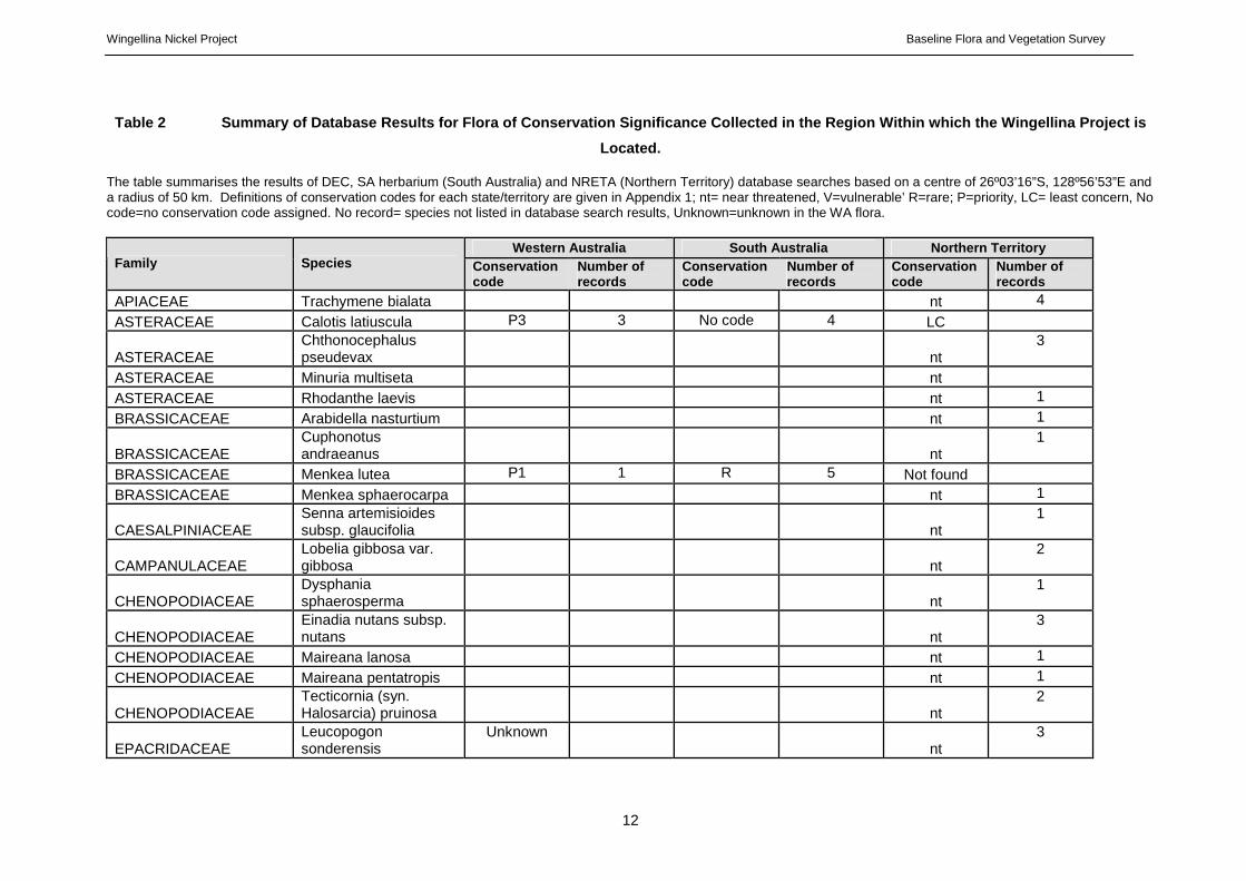
A total of 64 taxa ascribed a conservation code have been collected in the search area in Western
Australia, South Australia and the Northern Territory (Table 2 ). None of these taxa are considered
Declared Rare Flora, as defined under the Western Australian Wildlife Conservation Act 1950. Four
Priority taxa (as defined by the DEC) have been lodged with the Western Australian Herbarium from
the study area, and five other species that are ranked as Priority species in Western Australia have
been collected close by in the Northern Territory and/or South Australia, but not Western Australia,
although it could be assumed that they are found here.
Conservation codes and their application differed between WA, SA and NT databases. Four Priority
species in WA; Calotis latiuscula (P3), Acacia calcicola (P4), Eucalyptus sparsa (P3), and Stackhousia
clementii (P1), do not have conservation codes in SA or NT, and two of them (the Calotis and
Stackhousia) hold a ranking of LC (Least Concern) in the NT. By contrast, three species, Samolus
eramaeus, Dampiera roycei and Ophioglossum polyphyllum, are considered rare by SA but are not
assigned conservation codes in either WA or NT.
A number of species that have been listed as occurring within the 50km search area are unknown in
the Western Australian Flora, not having been collected in this State.
For the purpose of this report Conservation codes will be applied according to the situation in Western
Australia. For this reason the nine species that have Western Australian Conservation Codes are
considered of primary importance. Species with conservation rankings in other States are also
treated as significant.
4.1.3 Threatened Ecological Communities
No TECs or PECs were identified as potentially occurring within the Wingellina search area by the
DEC database search. No ecosystems at risk have been identified in the Western Australian part of
the CR1 bioregion (Graham and Cowan, 2001)
Wingellina Nickel Project Baseline Flora and Vegetation Survey
12
Table 2 Summary of Database Results for Flora of C onservation Significance Collected in the Region Wi thin which the Wingellina Project is
Located.
The table summarises the results of DEC, SA herbarium (South Australia) and NRETA (Northern Territory) database searches based on a centre of 26º03’16”S, 128º56’53”E and a radius of 50 km. Definitions of conservation codes for each state/territory are given in Appendix 1; nt= near threatened, V=vulnerable’ R=rare; P=priority, LC= least concern, No code=no conservation code assigned. No record= species not listed in database search results, Unknown=unknown in the WA flora.
Western Australia South Australia Northern Territory Family Species Conservation
code Number of records
Conservation code
Number of records
Conservation code
Number of records
APIACEAE Trachymene bialata nt 4
ASTERACEAE Calotis latiuscula P3 3 No code 4 LC
ASTERACEAE Chthonocephalus pseudevax
nt
3
ASTERACEAE Minuria multiseta nt ASTERACEAE Rhodanthe laevis nt 1
BRASSICACEAE Arabidella nasturtium nt 1
BRASSICACEAE Cuphonotus andraeanus
nt
1
BRASSICACEAE Menkea lutea P1 1 R 5 Not found
BRASSICACEAE Menkea sphaerocarpa nt 1
CAESALPINIACEAE Senna artemisioides subsp. glaucifolia
nt
1
CAMPANULACEAE Lobelia gibbosa var. gibbosa
nt
2
CHENOPODIACEAE Dysphania sphaerosperma
nt
1
CHENOPODIACEAE Einadia nutans subsp. nutans
nt
3
CHENOPODIACEAE Maireana lanosa nt 1
CHENOPODIACEAE Maireana pentatropis nt 1
CHENOPODIACEAE Tecticornia (syn. Halosarcia) pruinosa
nt
2
EPACRIDACEAE Leucopogon sonderensis
Unknown nt
3

Wingellina Nickel Project Baseline Flora and Vegetation Survey
13
Western Australia South Australia Northern Territory Family Species Conservation
code Number of records
Conservation code
Number of records
Conservation code
Number of records
EUPHORBIACEAE Monotaxis luteiflora nt 2
EUPHORBIACEAE Poranthera leiosperma nt 2
FRANKENIACEAE Frankenia punctata nt 2
GOODENIACEAE Dampiera dentata nt 5
GOODENIACEAE Dampiera roycei R 1 LC
GOODENIACEAE Goodenia brunnea Unknown R 1 nt 1
GOODENIACEAE Goodenia glandulosa nt 1
GOODENIACEAE Goodenia occidentalis nt 2
GOODENIACEAE Goodenia rupestris Unknown nt 1
HALORAGACEAE Glischrocaryon aureum var. angustifolium
nt
2
JUNCACEAE Juncus continuus Unknown nt 4
LAMIACEAE Microcorys macredieana
P3 No record No record No record nt
1
LAMIACEAE Prostanthera wilkieana nt 2
LAMIACEAE
Teucrium grandiusculum subsp. grandiusculum
P2 1 v 4
nt
1
LILIACEAE Arthropodium strictum Unknown nt 2
LILIACEAE Caesia chlorantha nt 1
LILIACEAE Tricoryne elatior nt 3
LILIACEAE Wurmbea centralis subsp. centralis
nt
11
LILIACEAE Wurmbea deserticola nt 1
LYTHRACEAE Lythrum paradoxum P3 1 No record Not record
MALVACEAE Hibiscus brachychlaenus
nt
1
MALVACEAE Sida calyxhymenia nt 5
MIMOSACEAE Acacia abbreviata Unknown nt 1
MIMOSACEAE Acacia ammobia Unknown nt 21
MIMOSACEAE Acacia auricoma P3 No record No record No record nt 18

Wingellina Nickel Project Baseline Flora and Vegetation Survey
14
Western Australia South Australia Northern Territory Family Species Conservation
code Number of records
Conservation code
Number of records
Conservation code
Number of records
MIMOSACEAE Acacia calcicola P4 1 No code 1 No record No record
MYOPORACEAE Eremophila alternifolia nt 9
MYOPORACEAE Eremophila clarkei nt 4
MYOPORACEAE Eremophila maculata subsp. brevifolia
nt
1
MYRTACEAE Eucalyptus sparsa P3 No record No code 5 dd 13
MYRTACEAE Melaleuca faucicola Unknown nt 4
MYRTACEAE Melaleuca fulgens subsp. corrugata
nt
2
OPHIOGLOSSACEAE Ophioglossum lusitanicum
nt
2
OPHIOGLOSSACEAE Ophioglossum polyphyllum
R 1
POACEAE Enneapogon caerulescens
nt
3
POACEAE Eragrostis sterilis unknown nt 5
POACEAE (Eriachne scleranthoides)
nt
7
PRIMULACEAE Samolus eremaeus No code R 2
PROTEACEAE Grevillea pterosperma nt 2
PROTEACEAE Hakea standleyensis unknown nt 1
RHAMNACEAE Stenanthemum petraeum
nt
11
SANTALACEAE Santalum acuminatum v 5
STACKHOUSIACEAE Stackhousia clementii P1 No record No code 1 LC 3
STERCULIACEAE Rulingia luteiflora nt 3
VERBENEACEAE Pityrodia loxocarpa nt 1
XANTHORRHOEACEAE Xanthorrhoea thorntonii nt 4
ZYGOPHYLLACEAE Zygophyllum ovatum nt 1

Wingellina Nickel Project Baseline Flora and Vegetation Survey
15
4.1.4 Review of Existing Reports
Beard, J. (1974). Great Victoria Desert. Explanatory Notes to Sheet 3, 1:1 000 000 Series.
Vegetation Survey of Western Australia.
This broad-scale vegetation mapping provides a generalised overview of the vegetation associations
of the Great Victoria Desert and the Eremaean Botanical Province as defined by Beard (1974).
Descriptions of the vegetation associations are the result of interpretation of aerial photographs and
ground-truthing.
The project area is located in the Giles Botanical District (sometimes referred to as the Warburton
Region) (Beard, 1974). The Giles Botanical District is approximately equivalent to the Central Ranges
1 (Mann-Musgrave Block Subregion) IBRA region. Beard (1974) broadly describes the vegetation of
the region in relation to the underlying topography as being very varied, from low rounded quartzite
ranges, sandy plains, confused dune systems, to salt lakes and kopi dunes.
Three of the vegetation communities described by Beard (1974) occur within the project area:
• Acacia aneura Low Woodland occurring mostly over sandhills, however some patches on
flat plains (a1Li).
• Acacia aneura Scrub occurring on stony hills (a1Si).
• Allocasuarina decaisneana, Melaleuca spp. steppe over Triodia basedowii, T. melvillei
grass steppe (c1mp2t2Hi).
Beard (1974) noted that the sandhills of the Giles Botanical District are often vegetated by Grevillea
stenobotrya, Acacia spp., Gyrostemon ramulosus, Crotalaria cunninghamii and Triodia melvillei.
Interdunal vegetation is typically a shrub steppe including Hakea lorea subsp. suberea (syn. Hakea
lorea subsp. lorea, Acacia pruinocarpa, A. aneura, A. cuthbertsonii, A. coriacea, Eucalyptus
gamophylla, E. oxymitra, Eremophila forrestii and Triodia basedowii. Groves of Allocasuarina
decaisneana were also observed with no apparent pattern in their distribution or density.
Halpern Glick Maunsell (HGM) (2002). Wingellina Baseline Biological Survey.
This report includes an inventory of all the flora and fauna recorded during a Level 1 survey of the
project area in April 2002 (an area of approx. 100 km2).
A total of 188 plants were recorded during this survey, 75 of which had not been previously recorded
for the area. No Declared Rare or Priority flora were identified. Six introduced taxa were recorded,
five of which were new records for the Central Ranges Bioregion. HGM concluded that a high level of
human activity in the vicinity of the Wingellina Community had exacerbated the spread of weed
species.
Seven vegetation communities were identified during the survey, none of which were restricted to the
survey area. None of the communities recorded in the survey are nationally listed as threatened

Wingellina Nickel Project Baseline Flora and Vegetation Survey
16
ecological communities under the EPBC Act. However, three communities were considered to be
regionally significant;
• Grassland of Poaceae spp. with occasional Senna glutinosa subsp. glutinosa and Sida
fibulifera in patches of cracking clay.
• Low Scrub over Triodia spp. in sand over sand dunes.
• Low Open Woodland of Eucalyptus gamophylla and Eucalyptus socialis subsp. eucentrica
over Acacia validinervia over mixed shrubs over Triodia scariosa in clay loam on upper
slopes of mafic ridges.
These vegetation communities were considered to be regionally significant due to their isolation and
underlying geomorphology.
A. C. Robinson, P. B. Copley, P. D. Canty, L. M. Ba ker and B. J. Nesbitt (Eds) (2003). A Biological Survey of the Anangu Pitjantjatjara Lands, South Australia.
This report includes an inventory of all the flora and fauna recorded during a survey of the Anangu-
Pitjantjatjara (AP) lands in the north-western region of South Australia. It forms part of a
comprehensive biological survey of South Australia spanning 10 years. A total of 719 species were
recorded in the Anangu-Pitjantjatjara lands, nearly 10% of which represented species new to the
State, region or science, attesting to the status of botanical knowledge in the area. A number of
species recorded in this survey are also known from collections within Western Australia.
Pearson D., Miller J., Butler M., Butler M., Brenna n K., Thompson W. (2006). Learning about country. Landscope Vol. 23 No.2 Summer 2007-08 Nat urebase, Department of Environment and Conservation
In 2006, a survey of the Ngaanyatjarra lands was undertaken by the Western Australia Museum
(WAM), Department of Environment and Conservation (DEC), South Australian Museum, Department
of Environment and Heritage (DEH) (South Australia) and the Ngaanyatjarra people. The survey
investigated flora, vertebrate fauna, invertebrates and subterranean fauna. Seven hundred and
twenty plant specimens were recorded, including thirty seven species that were either new records or
significant range extensions.
4.2 Field Survey
4.2.1 Flora composition
A total of 176 specimens were collected during the April 2008 survey of the Wingellina project area, of
which 154 have been identified to species level. Of the identified flora, there were 100 taxa (including
subspecies and variants) from 40 genera and 24 families. The flora was dominated by Mimosaceae,
with 17 taxa from 1 genus and Poaceae, with 16 taxa from 11 genera recorded (Table 4 ). The
families Caesalpiniaceae, Chenopodiaceae and Malvaceae were also species rich (Table 4 ).
A total of 22 specimens still require additional work to confirm identity. Within this collection, there are
samples that are considered to be potentially duplicates of samples that have been identified or are

Wingellina Nickel Project Baseline Flora and Vegetation Survey
17
samples collected to capture the range of variation within a species. This is particularly so for
samples of Eucalyptus species. The remaining specimens require significant attention and potentially
additional collections to facilitate identification.
A Site Species Matrix is provided as Appendix G .
Table 3 Summary of dominant plant families in the Wingellina study area
Family Number of Taxa Number of genera
Mimosaceae 17 1
Poaceae 16 11
Chenopodiaceae 12 6
Caesalpiniaceae 12 2
Malvaceae 6 4
4.2.2 Conservation Significant Flora Species and Ve getation Communities
No Declared Rare or Priority Flora were identified during the April 2008 flora and vegetation survey.
No TEcs or PECs were found to occur in the Wingellina study area
4.2.3 Introduced Flora
One introduced species, *Cenchrus ciliaris (Buffel Grass), was recorded during this survey. While not
recorded as having a large foliage cover, it was recorded in fourteen of the thirty quadrats, or 46%. Of
the quadrat records 2.7% were of this single introduced species and this is a marginal increase on the
2.5% of quadrat records that were introduced species in Robinson et al. (2003). However, these are
records of a single species and the previous survey shows records of 25 taxa recorded in that survey.
This would appear to show that the vegetation at Wingellina is becoming increasingly degraded by
invasion of *Cenchrus ciliaris. This is possibly a result of uncontrolled grazing by camels or by human
activities
4.2.4 Data Analysis
A dendrogram was produced using PRIMER, as reproduced below, and was used to help determine
groupings of vegetation units.

Wingellina Nickel Project Baseline Flora and Vegetation Survey
18
Figure 4 PRIMER dendrogram of relationships between vegetation communities
The dendrogram shows four major groupings in the vegetation based on presence/absence analysis,
and these are defined by the vertical red lines in Figure .4. These correspond broadly to
topographical features. A description of the basis for the site groupings is below, moving from left to
right across the x axis of Figure 4 :
Group 1: Q8-Q27; These sites are on sandplain around the hills and are predominately Mulga
woodlands,
Group 2: Q1-Q24; Eucalyptus Shrub Mallee on upper slopes and ridges,
Group 3: Q12-Q25; A mixture of sites from valleys, broad flats and drainages and the low hills
south/south-east of Wingellina of Eucalyptus Mallee over Mulga. Sites Q3 and Q4 are sites from
upper slopes and low ridges but have mixed Eucalyptus canopies as opposed to single species
Eucalyptus canopies, separating them out from others in Group 2.
Group 4: Q16-Q22; The same mixture of landform and canopy as Group 3, separated due to
differences in understorey species.
This analysis is consistent with the observed vegetation distribution in the study area and shows
results consistent with previous studies, although with more definition. The groupings of sites
represented in the dendrogram appear to show a realistic picture of vegetation relationships in the
Wingellina study area

Wingellina Nickel Project Baseline Flora and Vegetation Survey
19
4.2.5 Vegetation Types – Descriptions
Seven vegetation units were described from this survey of the Wingellina study area. The greatest
number of these units are composed of Eucalyptus Shrub Mallee, comprising various Eucalyptus
species. The quadrats recorded within each vegetation unit are listed after each description. A
vegetation map is included as Figure 5.
Ega
Eucalyptus gamophylla (Eucalyptus mannensis subsp. mannensis) (Very) Open Shrub Mallee over
Senna spp., Acacia spp. Open Shrubland/Scattered Shrubs over Triodia spp. Hummock Grassland on
upper slopes and ridges.
WIN 01, 02, 03, 04, 24
Eso
Eucalyptus socialis subsp. eucentrica Open Shrub Mallee occasionally with E. gamophylla, E.
mannensis subsp. mannensis Scattered Mallees over Acacia aneura, A. kempeana, A. oswaldii, A.
valdinervia Scattered Tall Shrubs/Open Shrubland/Low Shrubland over mixed shrubs over Triodia
spp. Hummock Grassland, Eragrostis eriopoda, Enteropogon ramosus Scattered Grasses/Very Open
Grassland. On valley floors and plains associated with increased moisture availability.
WIN 05, 10, 11, 12, 16, 23, 25, 26 28, 29
Egyp
Eucalyptus gypsophila (Very) Open Shrub Mallee often with E. socialis, subsp. eucentrica over mixed
Acacia spp. over Ptilotus obovatus var. obovatus Low Shrubland/Open Shrubland over Triodia
helmsii/T. pungens Hummock Grassland. On low hills and slopes.
WIN 06, 14, 19, 22, 30
Aca
Acacia aneura var. aneura, A. aneura var. intermedia Low Woodland-Scattered Tall Shrubs over
mixed Acacia spp., Senna artemisioides Scattered Shrubs/Open Shrubland over Eragrostis eriopoda,
Aristida spp., Enteropogon ramosus Open-Closed Grassland. On plains surrounding Wingellina.
WIN 07, 08, 09, 13, 15, 27
Hdi
Hakea divaricata Low Open Woodland over *Cenchrus ciliaris, Enteropogon ramosus Open
Grassland. Apparently restricted unit on flats.
WIN 17
Apr
Acacia pruinocarpa, Hakea lorea subsp. lorea Tall Open Shrubland over Senna artemisioides subsp.
oligophylla x helmsii, Acacia kempeana Low Open Shrubland over Triodia helmsii Hummock

Wingellina Nickel Project Baseline Flora and Vegetation Survey
20
Grassland, Cymbopogon obtectus Very Open Tussock Grassland. On low hills to the south of
Wingellina.
WIN 20
Ccot
Codonocarpus cotinifolius Low Open Woodland over Eucalyptus gamophylla Scattered Mallee over
Senna glutinosa , Acacia kempeana, Hakea lorea subsp. lorea Open Shrubland over Acacia
valdinervia, Ptilotus exaltatus var. exaltatus Low Open Shrubland over Triodia helmsii Hummock
Grassland, Cymbopogon obtectus Very Open Tussock Grassland. On low hills to the south of
Wingellina, outside the study area.
WIN 21
The Shrub Mallee and Mulga units described here largely correlate with those described by HGM in
2002, although boundaries may differ.
Three units described by HGM (2002) are not included as the sites were not surveyed due to time,
cultural or geographical constraints. These are HGM’s A2, A3 and B3(u), all small units in the context
of the overall site. HGM recommended that unit B3(u) remain undisturbed, and given the approximate
locations of A2 and A3 it is unlikely that they will be impacted. HGM was of the opinion that these
three units are of regional significance due to their isolation and underlying geomorphology.
Three of the units described by this survey appear to be restricted:
Hdi was recorded from one site to the south-east of the airstrip, in a broad valley between low hills.
After reviewing aerial photography it is possible that this unit is more widespread around the low hills
in the south of the study area than would be indicated by one sampling.
Apr was also recorded at one site, on a low hill in the south of the study area. As this landform is
repeated both within and outside the survey area it is likely this unit is not as restricted as may appear.
Ccot is described from one site that falls outside the southern tenement boundary, however the
northern extent of the low hill it is situated on is within the tenement. From available aerial
photography it would appear to be more common than one sample site shows.
These three vegetation units, due to their location within the tenement and their size, should be
treated as restricted until further information is gathered. None of them is likely to be impacted by any
proposed development at Wingellina.
Photographs of each site and its description are included in Appendix F .

Wingellina Nickel Project Baseline Flora and Vegetation Survey
21
Figure 5 Vegetation map of the Wingellina study are a

Wingellina Nickel Project Baseline Flora and Vegetation Survey
22
4.2.6 Vegetation Condition Assessment
The condition of vegetation within the study area was assessed using the scale of Keighery (1994)
(Appendix B ). The majority of vegetation within the survey area was assessed as being in excellent
to very good condition, using the scale of Keighery (1994) (Table 4 ). This assessment reflects
evidence of low level disturbance, in vegetation that was otherwise near pristine. The remaining
vegetation was assessed as being predominately in good condition, with a small number of sites
assessed as degraded (Table 4 ).
The main causes of disturbance to vegetation were considered to be repeated fires and grazing
damage by camels. Extensive areas of vegetation have been repeatedly burnt, which has resulted in
the loss of Acacia aneura var. aneura (Mulga) trees from many areas within the survey area.
Table 4 Vegetation condition assessment of survey sites within the study area.
Pristine Excellent Very good Good Degraded Completely degraded
Quadrats 1, 2, 3, 4, 5, 6, 7,
12, 19, 21, 22, 24, 26
14, 16, 20, 25, 30
9, 10, 11, 15, 17, 18, 23, 25, 29
8, 13, 27, 28
% of sites 0 43.3% 16.7% 26.7 13.3% 0

Wingellina Nickel Project Baseline Flora and Vegetation Survey
23
5.0 SUMMARY AND RECOMMENDATIONS
Outback Ecology undertook a flora and vegetation survey over the Wingellina project area in April
2008. This survey builds on previous baseline botanical information acquired by HGM (Maunsell)
during a Level 1 survey of the project area in 2002.
A search of relevant databases revealed that there are no Threatened or Priority Ecological
Communities or Declared Rare Flora (DRF) known within the Wingellina project area. In addition, this
survey did not collect specimens of any known DRF or Priority Flora, or identify any Threatened or
Priority Ecological Communities in the study area.
A total of 176 specimens were collected during the April 2008 survey of the Wingellina project area, of
which 154 have been identified. Of the identified flora, there were 100 taxa (including subspecies and
variants) from 40 genera and 24 families. The flora was dominated by Mimosaceae, with 17 taxa from
1 genus and Poaceae, with 16 taxa from 11 genera recorded. The families Caesalpiniaceae,
Chenopodiaceae and Malvaceae were also species rich. One alien taxon, *Cenchrus ciliaris (Buffel
grass), was recorded during the survey.
Vegetation units in the study area appear relatively uniform in distribution and are related to landform.
The descriptions and distribution of vegetation units in this report are believed to accurately represent
the vegetation present in the Wingellina study area. Three units described from this study were
sampled once and may be restricted, however they are to the south of the proposed mining area and
are unlikely to be impacted. Two minor vegetation units described by Maunsell (2002) were not
sampled during this survey due to time and access constraints imposed by traditional cultural events
occurring at the time of survey.
The following general management guidelines below are suggested to minimise potential impacts to
the flora and vegetation within the Wingellina project area:
• Reduce vegetation clearance to an absolute minimum where practicable.
• Conserve topsoil and progressively rehabilitate waste dumps, tailings dams and pits with local
flora species to an appropriate standard
• Minimise impacts to surface hydrology by avoiding drainage features wherever possible, as
this may be important for long-term Mulga growth
• Assess the likely impact of dewatering and any groundwater drawdown on vegetation
• Implement standard dust suppression strategies across the project area, during both
construction and operation periods, to reduce impacts to surrounding vegetation.
• Systematic culling of camels where practicable to reduce the negative impacts on surviving
Mulga woodlands

Wingellina Nickel Project Baseline Flora and Vegetation Survey
24
• Prevent the establishment of new weed species, and the further spread of existing weed
species
• Consider the preparation and implementation of a comprehensive Fire Management Plan, not
only to reduce the risk of fire within the project area, but also to mitigate against wildfire from
off-site ignition sources.

Wingellina Nickel Project Baseline Flora and Vegetation Survey
25
6.0 References
Beard, J.S. (1975). Vegetation Survey of Western Australia. Pilbara (1:1 000 000 Vegetation Series).
University of Western Australia Press, WA.
Bureau of Meteorology (BOM) (2007) Climate statistics for Australian locations. [Online]. Available:
http://www.bom.gov.au/lsp/ncc/cdio/cvg/av [2008, 10th June].
Graham and Cowan (2001). Central Ranges 1 (CR1 – Mann-Musgrave Block subregion) In May, J. &
McKenzie, N. (Eds) A Biodiversity Audit of Western Australia’s 53 Biogeographical Subregions in
2002. Department of CALM (CALM, now DEC) pp 466 – 479. URL:
www.naturbase.net/pdf/science/bio_audit/murchison01_p466-479.pdf (Accessed: February 13th, 2007)
Department of Environment and Conservation (DEC) (2007). Declared Rare and Priority Flora List for
Western Australia.
Department of Industry and Resources (DoIR) (2006). Information Series: Guidelines for the
Management of Declared Flora for Onshore Petroleum and Mineral Activities, Special Series 16.
Department of Industry and Resources, Western Australia.
English, V. (2003). Threatened Ecological Communities – Methods, Listing, Examples. In
Proceedings of the Threatened Ecological Communities Symposium. Technology Park, Bentley,
Western Australia, 2nd December 2003.
English, V. and Blyth, J. (1997). Identifying and Conserving Threatened Ecological Communities in
the South West Botanical Province ANCA National Reserves System Cooperative Programme:
Project Number N702. Final Report, May 1997.
EPA (2002). Environmental Protection Authority. Terrestrial Biological Surveys as an Element of
Biodiversity Protection. Position Statement No 3. March 2003.
EPA (2004). Environmental Protection Authority. Guidance for the Assessment of Environmental
Factors. Terrestrial Flora and Vegetation Surveys for Environmental Impact Assessment in Western
Australia. No 51. June, 2004.
Keighery, B. (1994). Bushland Plant Survey – A guide to Plant Community Survey for the Community,
Wildflower Society of WA (Inc.)
Muir, B.G (1977) Biological Survey of the Western Australian Wheatbelt. Pt. 2. Vegetation and habitat
of the Bendering Reserve. Rec. West. Aust. Mus. Supp. 3.

Wingellina Nickel Project Baseline Flora and Vegetation Survey
26
NLWRA, (2002). National Land and Water Resources Audit (1997 – 2002). A program of the
Australian Government Natural Heritage Trust www.nlwra.gov.au (Accessed May 25th, 2007)
NLRWA
Naturebase – General Definitions [Department of Environment and Conservation]. (2005, 20 Sept.-
last modified). [Online]. Available:
http://www.naturebase.net/plants_animals/watscu/tec_definitions.html [2007, 21st May].
Paczkowska, G. and Chapman, A.R. (2000). The Western Australian Flora: A Descriptive Catalogue.
Wildflower Society of Western Australia, Nedlands, Western Australian Herbarium, CALM, (Perth) and
Botanic Gardens and Parks Authority, (West Perth).
Thackway, R and Cresswell, I.D. (eds) (1995) An interim biogeographical regionalisation of Australia.
Australian Nature Conservation Agency (now DEH), Canberra.
Western Australian Herbarium (2007). FloraBase — The Western Australian Flora. Department of
Conservation and Land Management. http://florabase.calm.wa.gov.au/

27
Appendix A
Definitions of Declared Rare and Priority Flora and Threatened Ecological
Community Classifications

28
Definition of Declared Rare and Priority Flora Spec ies (CALM, 2005)
Conservation Code Category Description
R Declared Rare Flora – Extant Taxa “Taxa which have been adequately searched for and are deemed to be in the wild either rare, in danger of extinction, or otherwise in need of special protection, and have been gazetted as such.”
P1
Priority One – Poorly Known Taxa “Taxa which are known from one or a few (generally <5) populations which are under threat, either due to small population size, or being on lands under immediate threat, e.g. road verges, urban areas, farmland, active mineral leases, etc. May include taxa with threatened populations on protected lands. Such taxa are under consideration for declaration as ‘rare flora’, but are in urgent need of further survey.”
P2
Priority Two – Poorly Known Taxa “Taxa which are known from one or a few (generally <5) populations, at least some of which are not believed to be under immediate threat (i.e. not currently endangered). Such taxa are under consideration for declaration as ‘rare flora’ but are in urgent need of further survey.”
P3
Priority Three – Poorly Known Taxa “Taxa which are known from several populations, and the taxa are not believed to be under immediate threat (i.e. not currently endangered), either due to the number of known populations (generally >5), or known populations being large, and either widespread or protected. Such taxa are under consideration for declaration as ‘rare flora’ but are in need of further survey.”
P4 Priority Four – Poorly Known Taxa “Taxa which are considered to have been adequately surveyed and which, whilst being rare (in Australia) are not currently threatened by any identifiable factors. These taxa require monitoring every 5 – 10 years.”
Definition of Threatened Ecological Community class ifications (English, 2003)
TEC Classification Description
Presumed Totally Destroyed Community is unlikely to be able to be rehabilitated.
Critically Endangered There are immediate threats throughout its range.
Endangered Threatened throughout most of its range in near future.
Vulnerable Vulnerable to threatening processes/may move into higher threat category.

29
Appendix B
Vegetation Condition Scale

30
Vegetation Condition Scale (Keighery, 1994).
Code Description
Pristine Pristine or nearly so. No obvious signs of disturbance.
Excellent Vegetation structure intact, disturbance affecting individual species and weeds are non-aggressive species.
Very Good
Vegetation structure altered, obvious signs of disturbance. For example, disturbance to vegetation structure caused by repeated fires, the presence of some more aggressive weeds, dieback, logging and grazing.
Good
Vegetation structure significantly altered by very obvious signs of multiple disturbances. Retains basic vegetation structure or ability to regenerate it. For example, disturbance to vegetation structure caused by very frequent fires, the presence of some very aggressive weeds at high density, partial clearing, dieback and grazing.
Degraded
Basic vegetation structure severely impacted by disturbance. Scope for regeneration but not to a state approaching good condition without intensive management. For example, disturbance to vegetation structure caused by very frequent fires, the presence of very aggressive weeds, partial clearing, dieback and grazing.
Completely Degraded
The structure of the vegetation is no longer intact and the area is completely or almost completely without native species. These areas are often described as ‘parkland cleared’ with the flora comprising weed or crop species with isolated native trees or shrubs.

31
Appendix C
Classification of Vegetation Structural Formation a nd Height Classes

32
Vegetation Structure Classification (Keighery 1994)
Life Form/ Height Class
Canopy Cover (percentage)
100% - 70% 70% - 30% 30% - 10% 10% - 2%
Trees 10-30m Trees < 10m
Closed Forest Low Closed Forest
Open Forest Low Open Forest
Woodland Low Woodland
Open Woodland Low Open Woodland
Shrub Mallee Closed Shrub Mallee
Shrub Mallee Open Shrub Mallee
Very Open Shrub Mallee
Shrubs > 2m Shrubs 1-2m Shrubs <1m
Closed Tall Scrub Closed Heath Closed Low Heath
Tall Open Scrub Open Heath Open Low Heath
Tall Shrubland Shrubland Low Shrubland
Tall Open Shrubland Open Shrubland Low Open Shrubland
Grasses Closed Grassland
Grassland Open Grassland
Very Open Grassland
Herbs Closed Herbland
Herbland Open Herbland
Very Open Herbland
Sedges Closed Sedgeland
Sedgeland Open Sedgeland
Very Open Sedgeland

33
Appendix D
DEC Database Searches

34
WAHERB SPECIMEN DATABASE GENERAL ENQUIRY
Calotis latiuscula F.Muell. & Tate (Asteraceae) CONSERVATION STATUS:P3 Coll.: A.S. George 5228 Date: 21 07 1963 ( PERTH 00421952 ) LOCALITY Mt Aloysius E of Blackstone Range WA LAT 26 Deg 2 Min 0.000 Sec S LONG 128 Deg 35 Min 59.000 Sec E near creek bed on rocky hillside Previous det.: Calotis latiuscula F.Muell.& Tate Calotis latiuscula F.Muell. & Tate (Asteraceae) CONSERVATION STATUS:P3 Coll.: A.S. George 4849 Date: 08 07 1963 ( PERTH 00421960 ) LOCALITY Mount Fanny, NE of Blackstone Range WA LAT 25 Deg 47 Min 0.000 Sec S LONG 128 Deg 34 Min 7.000 Sec E Herb to 50 cm. Flowers yellow. On rocky hillside. Previous det.: Calotis latiuscula F.Muell.& Tate Calotis latiuscula F.Muell. & Tate (Asteraceae) CONSERVATION STATUS:P3 Coll.: D.J. Edinger, B. & B. Backhouse & G. M DJE 2434 Date: 06 05 2001 ( PERTH 05853303 ) LOCALITY On plain at base of Mount Aloysius, 27 km E of Blackstone, Central Ranges, WA LAT 25 Deg 58 Min 19.900 Sec S LONG 128 Deg 34 Min 10.800 Sec E Daisy, flowers yellow. Under trees. Frequency:common. Lythrum paradoxum Koehne (Lythraceae) CONSERVATION STATUS:P3 Coll.: B. Lay 865 Date: 29 08 1973 ( PERTH 04903242 ) LOCALITY Fanny's Peak [Mount Fanny], ca 85 km S of Giles Meteorological Station, on road to Warburton Mission WA LAT 25 Deg 47 Min 0.000 Sec S LONG 128 Deg 34 Min 42.000 Sec E Perennial. Shrub 1 m high x 2 m in diameter. Rocky gully. Previous det.: Lythrum paradoxum Koehne Frequency:common. Menkea lutea E.A.Shaw (Brassicaceae) CONSERVATION STATUS:P1 Coll.: Symon D.E. 2165 Date: 31 07 1962 ( PERTH 1138847 ) LOCALITY Wingelena air strip, Tomkinson Range. WA LAT 26 Deg 3 Min Sec S LONG 128 Deg 48 Min Sec E Flowers bright yellow. Teucrium grandiusculum F.Muell. & Tate subsp. grandiusculum (Lamiaceae) CONSERVATION STATUS:P2 Coll.: D.J. Pearson DJP 632 Date: 25 06 1989 ( PERTH 1158902 ) LOCALITY Purnawara Rockhole, 4 km N of Boundary Peak, Bell Rock Range, WA LAT 26 Deg 18 Min Sec S LONG 128 Deg 48 Min Sec E Dwarf shrub 50 cm tall. Flowers white. On rocky slope in red sand. In hummock grassland with Triodia sp., Dodonaea sp., Ptilotus spp. Previous det.: Teucrium grandiusculum F.Muell.& Tate Frequency:occasional.

35
Appendix E
Environment Protection and Biodiversity Conservation (EPBC) Act Protected
Matters Database Search

36
EPBC Act Protected Matters Report This report provides general guidance on matters of national environmental significance and other matters protected by the EPBC Act in the area you have selected. Information on the coverage of this report and qualifications on data supporting this report are contained in the caveat at the end of the report. You may wish to print this report for reference before moving to other pages or websites. The Australian Natural Resources Atlas at http://www.environment.gov.au/atlas may provide further environmental information relevant to your selected area. Information about the EPBC Act including significance guidelines, forms and application process details can be found at http://www.environment.gov.au/epbc/assessmentsapprovals/index.html
This map may contain data which are © Commonwealth of Australia (Geoscience Australia) © 2007 MapData Sciences Pty Ltd, PSMA
Search Type: Point Buffer: 100 km
Coordinates: -26.06803,128.9651
Report Contents: Summary Details • Matters of NES • Other matters protected by the EPBC Act •Extra Information Caveat Acknowledgments
Summary Matters of National Environmental Significance This part of the report summarises the matters of national environmental significance that may occur in, or may relate to, the area you nominated. Further information is available in the detail part of the report, which can be accessed by scrolling or following the links below. If you are proposing to undertake an activity that may have a significant impact on one or more matters of national environmental significance then you should consider the Administrative Guidelines on Significance - see http://www.environment.gov.au/epbc/assessmentsapprovals/guidelines/index.html.
World Heritage Properties: None
National Heritage Places: None
Wetlands of International Significance: (Ramsar Sites)
None
Commonwealth Marine Areas: None Threatened Ecological Communities: None
Threatened Species: 5

37
Migratory Species: 5
Other Matters Protected by the EPBC Act This part of the report summarises other matters protected under the Act that may relate to the area you nominated. Approval may be required for a proposed activity that significantly affects the environment on Commonwealth land, when the action is outside the Commonwealth land, or the environment anywhere when the action is taken on Commonwealth land. Approval may also be required for the Commonwealth or Commonwealth agencies proposing to take an action that is likely to have a significant impact on the environment anywhere. The EPBC Act protects the environment on Commonwealth land, the environment from the actions taken on Commonwealth land, and the environment from actions taken by Commonwealth agencies. As heritage values of a place are part of the 'environment', these aspects of the EPBC Act protect the Commonwealth Heritage values of a Commonwealth Heritage place and the heritage values of a place on the Register of the National Estate. Information on the new heritage laws can be found at http://www.environment.gov.au/heritage/index.html. Please note that the current dataset on Commonwealth land is not complete. Further information on Commonwealth land would need to be obtained from relevant sources including Commonwealth agencies, local agencies, and land tenure maps. A permit may be required for activities in or on a Commonwealth area that may affect a member of a listed threatened species or ecological community, a member of a listed migratory species, whales and other cetaceans, or a member of a listed marine species. Information on EPBC Act permit requirements and application forms can be found at http://www.environment.gov.au/epbc/permits/index.html.
Commonwealth Lands: 1 Commonwealth Heritage Places: None
Places on the RNE: 1
Listed Marine Species: 4
Whales and Other Cetaceans: None
Critical Habitats: None
Commonwealth Reserves: None
Extra Information This part of the report provides information that may also be relevant to the area you have nominated.
State and Territory Reserves: 2
Other Commonwealth Reserves: None
Regional Forest Agreements: None
Details Matters of National Environmental Significance
Threatened Species [ Dataset Information ] Status Type of Presence
Birds
Leipoa ocellata Malleefowl
Vulnerable Species or species habitat likely to occur within area
Mammals
Dasycercus cristicauda Mulgara
Vulnerable Species or species habitat likely to occur within area

38
Notoryctes typhlops Yitjarritjarri, Southern Marsupial Mole
Endangered Species or species habitat likely to occur within area
Petrogale lateralis MacDonnell Ranges race Warru, Black-footed Rock-wallaby (MacDonnell Ranges race)
Vulnerable Species or species habitat may occur within area
Reptiles
Egernia kintorei Great Desert Skink, Tjakura, Warrarna, Mulyamiji
Vulnerable Species or species habitat may occur within area
Migratory Species [ Dataset Information ] Status Type of Presence
Migratory Terrestrial Species
Birds
Leipoa ocellata Malleefowl
Migratory Species or species habitat likely to occur within area
Merops ornatus Rainbow Bee-eater
Migratory Species or species habitat may occur within area
Migratory Wetland Species
Birds
Charadrius veredus Oriental Plover, Oriental Dotterel
Migratory Species or species habitat may occur within area
Glareola maldivarum Oriental Pratincole
Migratory Species or species habitat may occur within area
Migratory Marine Birds
Apus pacificus Fork-tailed Swift
Migratory Species or species habitat may occur within area
Other Matters Protected by the EPBC Act
Listed Marine Species [ Dataset Information ] Status Type of Presence
Birds
Apus pacificus Fork-tailed Swift
Listed - overfly marine area
Species or species habitat may occur within area
Charadrius veredus Oriental Plover, Oriental Dotterel
Listed - overfly marine area
Species or species habitat may occur within area
Glareola maldivarum Oriental Pratincole
Listed - overfly marine area
Species or species habitat may occur within area
Merops ornatus Rainbow Bee-eater
Listed - overfly marine area
Species or species habitat may occur within area
Commonwealth Lands [ Dataset Information ]
Defence
Places on the RNE [ Dataset Information ] Note that not all Indigenous sites may be listed.

39
Natural
Ranges of the Western Desert WA Extra Information
State and Territory Reserves [ Dataset Information ]
Ngaanyatjarra Lands Indigenous Protected Area, WA
Watarru Indigenous Protected Area, SA
Caveat The information presented in this report has been provided by a range of data sources as acknowledged at the end of the report. This report is designed to assist in identifying the locations of places which may be relevant in determining obligations under the Environment Protection and Biodiversity Conservation Act 1999. It holds mapped locations of World Heritage and Register of National Estate properties, Wetlands of International Importance, Commonwealth and State/Territory reserves, listed threatened, migratory and marine species and listed threatened ecological communities. Mapping of Commonwealth land is not complete at this stage. Maps have been collated from a range of sources at various resolutions. Not all species listed under the EPBC Act have been mapped (see below) and therefore a report is a general guide only. Where available data supports mapping, the type of presence that can be determined from the data is indicated in general terms. People using this information in making a referral may need to consider the qualifications below and may need to seek and consider other information sources. For threatened ecological communities where the distribution is well known, maps are derived from recovery plans, State vegetation maps, remote sensing imagery and other sources. Where threatened ecological community distributions are less well known, existing vegetation maps and point location data are used to produce indicative distribution maps. For species where the distributions are well known, maps are digitised from sources such as recovery plans and detailed habitat studies. Where appropriate, core breeding, foraging and roosting areas are indicated under "type of presence". For species whose distributions are less well known, point locations are collated from government wildlife authorities, museums, and non-government organisations; bioclimatic distribution models are generated and these validated by experts. In some cases, the distribution maps are based solely on expert knowledge. Only selected species covered by the migratory and marine provisions of the Act have been mapped. The following species and ecological communities have not been mapped and do not appear in reports produced from this database: threatened species listed as extinct or considered as vagrants some species and ecological communities that have only recently been listed some terrestrial species that overfly the Commonwealth marine area migratory species that are very widespread, vagrant, or only occur in small numbers. The following groups have been mapped, but may not cover the complete distribution of the species: non-threatened seabirds which have only been mapped for recorded breeding sites; seals which have only been mapped for breeding sites near the Australian continent. Such breeding sites may be important for the protection of the Commonwealth Marine environment. Acknowledgments This database has been compiled from a range of data sources. The Department acknowledges the following custodians who have contributed valuable data and advice: New South Wales National Parks and Wildlife Service Department of Sustainability and Environment, Victoria Department of Primary Industries, Water and Environment, Tasmania Department of Environment and Heritage, South Australia Planning SA Parks and Wildlife Commission of the Northern Territory Environmental Protection Agency, Queensland Birds Australia Australian Bird and Bat Banding Scheme

40
Australian National Wildlife Collection Natural history museums of Australia Queensland Herbarium National Herbarium of NSW Royal Botanic Gardens and National Herbarium of Victoria Tasmanian Herbarium State Herbarium of South Australia Northern Territory Herbarium Western Australian Herbarium Australian National Herbarium, Atherton and Canberra University of New England Other groups and individuals

41
Appendix F
Site Vegetation Descriptions and Photographs

42
Plate 1 - Win001 Eucalyptus gamophylla Very Open Shrub Mallee over Senna artemisioides subsp. oligophylla x helmsii, Acacia oswaldii Low Open Shrubland over Triodia schinzii (Closed) Hummock Grassland
Plate 2 - Win002 Eucalyptus gamophylla Open Shrub Mallee over Senna glaucifolia Scattered Shrubs over Dodonaea viscosa subsp. spathulata Open/Closed Low Heath

43
Plate 3 - Win003 Eucalyptus gamophylla, Eucalyptus mannensis subsp. mannensis Open Mallee Shrubland over Eremophila duttonii Low Open Shrubland over Triodia helmsii Hummock Grassland
Plate 4 - Win004 Eucalyptus gamophylla, E. mannensis subsp. mannensis Mallee Shrubland over Acacia kempeana, Senna artemisioides subsp. artemisioides Tall Shrubland over Ptilotus obovatus var. obovatus Open Shrubland over Rahgodia eremaea Low Open Shrubland over Triodia helmsii Closed Hummock Grassland

44
Plate 5 - Win005 Eucalyptus socialis subsp. eucentrica Very Open Shrub Mallee over Scattered mixed Acacia spp. over Ptilotus obovatus var. obovatus Low Shrubland over Triodia helmsii Hummock Grassland, Eragrostis eriopoda, Digitaria ammophila, Aristida contorta, A. holathera var. holathera Open Tussock Grassland
Plate 6 - Win006 Eucalyptus gypsophila, E. socialis subsp. eucentrica Shrub Mallee over Acacia kempeana, A. nyssophylla Scattered Tall Shrubs over Ptilotus obovatus var. obovatus Low Shrubland over Triodia helmsii Hummock Grassland

45
Plate 7 - Win007 Acacia aneura var. aneura, A. aneura var. intermedia Tall Open Shrubland over Eremophila latrobei var. latrobei, Senna glaucifolia Open Shrubland over Ptilotus obovatus var. obovatus Low Shrubland over Triodia helmsii Hummock Grassland, *Cenchrus ciliaris, Enneapogon caerulescens var. caerulescens, Eragrostis eriopoda Open Tussock Grassland
Plate 8 - Win008 Acacia aneura var. aneura Low Open Woodland over A. aneura var. conifera, Sida excedentifolia Scattered Low Shrubs over Eragrostis sp. (BGN050), Enteropogon ramosus, Eragrostis eriopoda Open Tussock Grassland

46
Plate 9 - Win009 Acacia aneura var. aneura, A. aneura var. intermedia Tall Open Shrubland over Senna artemisioides subsp. filifolia Open Shrubland over Eragrostis eriopoda Grassland
Plate 10 - Win010 Eucalyptus socialis subsp. eucentrica Very Open Shrub Mallee over Acacia kempeana Low Open Shrubland over Triodia helmsii Hummock Grassland, Eragrostis eriopoda Very Open Grassland
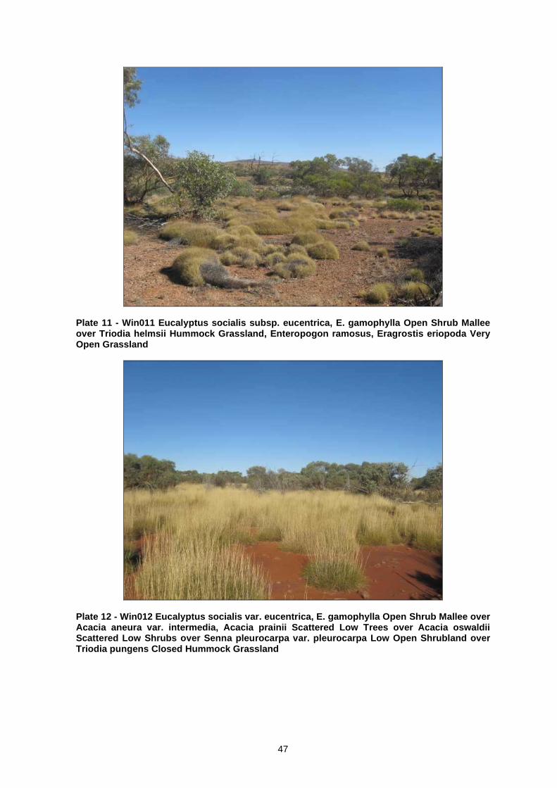
47
Plate 11 - Win011 Eucalyptus socialis subsp. eucentrica, E. gamophylla Open Shrub Mallee over Triodia helmsii Hummock Grassland, Enteropogon ramosus, Eragrostis eriopoda Very Open Grassland
Plate 12 - Win012 Eucalyptus socialis var. eucentrica, E. gamophylla Open Shrub Mallee over Acacia aneura var. intermedia, Acacia prainii Scattered Low Trees over Acacia oswaldii Scattered Low Shrubs over Senna pleurocarpa var. pleurocarpa Low Open Shrubland over Triodia pungens Closed Hummock Grassland

48
Plate 13 - Win013 Acacia aneura var. aneura, Acacia tetragonophylla Scattered Tall Shrubs over Senna artemisioides subsp. artemisioides Scattered Shrubs over Sclerolaena sp. (BGN087) Open Low Heath over Aristida contorta, A. latifolia Closed Tussock Grassland
Plate 14 - Win014 Eucalyptus gypsophila, E. socialis subsp. eucentrica Open Shrub Mallee over Ptilotus obovatus var. obovatus Low Open Shrubland over Triodia helmsii Hummock Grassland

49
Plate 15 - Win015 Acacia kempeana, Acacia aneura var. intermedia Tall Open Scrub over Ptilotus obovatus var. obovatus Low (Open) Shrubland over Eragrostis eriopoda, *Cenchrus ciliaris Very Open Grassland
Plate 16 - Win016 Eucalyptus socialis subsp. eucentricia Open Shrub Mallee over Acacia oswaldii Shrubland over Acacia kempeana, Ptilotus obovatus var. obovatus, Rhagodia eremaea Low Shrubland over Triodia scariosa Hummock Grassland, Enteropogon ramosus Scattered Grasses

50
Plate 17 - Win017 Hakea divaricata Low Open Woodland over *Cenchrus ciliaris, Enteropogon ramosus Open Grassland
Plate 18 - Win019 Eucalyptus gypsophila Very Open Shrub Mallee over Acacia pruinocarpa, A. valdinervia, Eremophila alternifolia, Hakea lorea subsp. lorea Shrubland over Halgania cyanea Low Open Shrubland over Triodia helmsii Hummock Grassland, Cymbopogon obtectus Very Open Grassland

51
Plate 19 - Win020 Acacia pruinocarpa, Hakea lorea subsp. lorea Tall Open Shrubland over Senna artemisioides subsp. oligophylla x helmsii, Acacia kempeana Low Open Shrubland over Triodia helmsii Hummock Grassland, Cymbopogon obtectus Very Open Tussock Grassland
Plate 20 - Win021 Codonocarpus cotinifolius Low Open Woodland over Eucalyptus gamophylla Scattered Mallee over Senna glutinosa , Acacia kempeana, Hakea lorea subsp. lorea Open Shrubland over Acacia valdinervia, Ptilotus exaltatus var. exaltatus Low Open Shrubland over Triodia helmsii Hummock Grassland, Cymbopogon obtectus Very Open Tussock Grassland

52
Plate 21 - Win022 Eucalyptus gypsophila, E. socialis subsp. eucentrica, E. trivalva Open Shrub Mallee over Acacia clelandii, Eremophila glabra subsp. glabra Tall Open Shrubland over Senna glaucifolia, Acacia nysophylla Open Shrubland over Ptilotus obovatus var. obovatus Low Open Shrubland over Triodia pungens Hummock Grassland, *Cenchrus ciliaris Scattered Grasses
Plate 22 - Win023 Eucalyptus socialis subsp. eucentrica, E. gypsophila Open Shrub Mallee over Acacia oswaldii, A. pruinocarpa Tall Open Shrubland over Senna artemisioides subsp. artemisioides Open Shrubland over Triodia helmsii Hummock Grassland
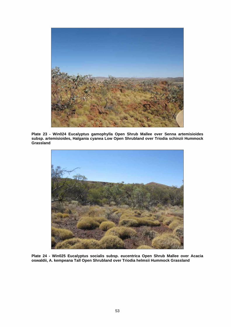
53
Plate 23 - Win024 Eucalyptus gamophylla Open Shrub Mallee over Senna artemisioides subsp. artemisioides, Halgania cyanea Low Open Shrubland over Triodia schinzii Hummock Grassland
Plate 24 - Win025 Eucalyptus socialis subsp. eucentrica Open Shrub Mallee over Acacia oswaldii, A. kempeana Tall Open Shrubland over Triodia helmsii Hummock Grassland

54
Plate 25 - Win026 Eucalyptus socialis subsp. eucentrica, E. mannensis subsp. mannensis Open Shrub Mallee over Acacia kempeana, A. valdinervia Open Shrubland over Triodia helmsii Hummock Grassland
Plate 26 - Win027 Acacia aneura var. aneura, A. aneura var. intermedia, Hakea lorea subsp. lorea Tall Shrubland over Aristida contorta, Cymbopogon obtectus, Eragrostis sp. (BGN084) Grassland

55
Plate 27 - Win028 Eucalyptus socialis subsp. eucentrica Open Shrub Mallee over Acacia kempeana, A. pruinocarpa, Senna artemisioides subsp. artemisioides, Halgania cyanea Low Shrubland over Trioidia helmsii Closed Hummock Grassland
Plate 28 - Win029 Eucalyptus socialis subsp. eucentrica Very Open Shrub Mallee over Acacia aneura var. intermedia Scattered Tall Shrubs over Acacia oswaldii, Senna artemisioides subsp. artemisioides, Rhagodia eremaea Shrubland over Ptilotus obovatus var. obovatus Low Open Shrubland over Triodia helmsii Very Open Hummock Grassland

56
Plate 29 - Win030 Eucalyptus gypsophila Open Shrub Mallee over Acacia aneura var. aneura Scattered Tall Shrubs over Halgania cyanea, Ptilotus obovatus var. obovatus Low Open Shrubland over Triodia helmsii Hummock Grassland

57
Appendix F
Site x Species Matrix

58
Survey Site No Family Genus Species 001 002 003 004 005 006 007 008 009 010 011 012 013 014 015 016 017 018 019 020 021 022 023 024 025 026 027 028 029 030
Amaranthaceae Ptilotus clementii + Amaranthaceae Ptilotus exaltatus var. exaltatus + + + + + Amaranthaceae Ptilotus helipteroides + Amaranthaceae Ptilotus obovatus var. obovatus + + + + + + + + + + + + + + + + + + + + + Amaranthaceae Ptilotus sp. + + Asteraceae Chrysocephalum apiculatum + Asteraceae Chrysocephalum eremaeum + Asteraceae Olearia sp. + Asteraceae Olearia stuartii + Asteraceae Pterocaulon serrulatum + + + + + Asteraceae Rhodanthe floribunda + Asteraceae Senecio magnificus + Boraginaceae Halgania cyanea + + + + + + Brassicaceae Lepidium phlebopetalum + Caesalpiniaceae Petalostylis cassioides + Caesalpiniaceae Senna artemisioides subsp.
artemisioides + + + + + + + + + +
Caesalpiniaceae Senna artemisioides subsp. filifolia + + Caesalpiniaceae Senna artemisioides subsp.
oligophylla + +
Caesalpiniaceae Senna artemisioides subsp. oligophylla x helmsii
+ + + + +
Caesalpiniaceae Senna artemisioides subsp. petiolaris + Caesalpiniaceae Senna glaucifolia + + + + Caesalpiniaceae Senna glutinosa + + + Caesalpiniaceae Senna pleurocarpa + + Caesalpiniaceae Senna sp. + + Chenopodiaceae Enchylaena tomentosa var.
tomentosa + +
Chenopodiaceae Eremophea spinosa + + Chenopodiaceae Maireana eriosphaera + + + Chenopodiaceae Maireana scleroptera + + Chenopodiaceae Maireana sp. + + + + Chenopodiaceae Rhagodia eremaea + + + + + + + + + + + +

59
Survey Site No Family Genus Species 001 002 003 004 005 006 007 008 009 010 011 012 013 014 015 016 017 018 019 020 021 022 023 024 025 026 027 028 029 030
Chenopodiaceae Salsola tragus + + + + + + + + + + + Chenopodiaceae Sclerolaena convexula + Chenopodiaceae Sclerolaena parviflora + + Chenopodiaceae Sclerolaena patenticuspis + + + Chenopodiaceae Sclerolaena sp. + + + Cucurbitaceae Mukia maderaspatana + + + Euphorbiaceae Euphorbia australis + + + Euphorbiaceae Euphorbia boophthona + + + + Goodeniaceae Goodenia glandulosa + Goodeniaceae Goodenia ramelii + Goodeniaceae Scaevola spinescens + Gyrostemonaceae Codonocarpus cotinifolius + Loranthaceae Amyema maidenii subsp. maidenii + + + Loranthaceae Amyema miquelii + Malvaceae Abutilon leucopetalum + + Malvaceae Alyogyne pinoniana + Malvaceae Hibiscus leptocladus + + Malvaceae Sida calyxhymenia + + + + + + + + + + + + + + + + + Malvaceae Sida excedentifolia + + Malvaceae Sida sp. + + + + + + + + + + + + + + + Mimosaceae Acacia aneura var. aneura + + + + + + Mimosaceae Acacia aneura var. conifera + + + Mimosaceae Acacia aneura var. intermedia + + + + + + + Mimosaceae Acacia aneura var. major + Mimosaceae Acacia aneura var. tenuis + Mimosaceae Acacia clelandii + + Mimosaceae Acacia dictyophleba + Mimosaceae Acacia kempeana + + + + + + + + + + + + + Mimosaceae Acacia minyura + Mimosaceae Acacia nyssophylla + + + + + Mimosaceae Acacia oswaldii + + + + + + + + + + Mimosaceae Acacia prainii + Mimosaceae Acacia pruinocarpa + + + + +

60
Survey Site No Family Genus Species 001 002 003 004 005 006 007 008 009 010 011 012 013 014 015 016 017 018 019 020 021 022 023 024 025 026 027 028 029 030
Mimosaceae Acacia sp. + Mimosaceae Acacia strongylophylla + + Mimosaceae Acacia tetragonophylla + + + + + Mimosaceae Acacia validinervia + + + + + + + + Mimosaceae Acacia victoriae + + + + Myoporaceae Eremophila alternifolia + + + Myoporaceae Eremophila duttonii + + + + + Myoporaceae Eremophila glabra subsp. glabra + + + + Myoporaceae Eremophila latrobei subsp. latrobei + + + + + Myoporaceae Eremophila sp. + + Myrtaceae Eucalyptus camaldulensis var. obtusa + Myrtaceae Eucalyptus gamophylla + + + + + + + Myrtaceae Eucalyptus gypsophila + + + + + Myrtaceae Eucalyptus mannensis subsp.
mannensis + + + +
Myrtaceae Eucalyptus socialis subsp. eucentrica + + + + + + + + + + + + Myrtaceae Eucalyptus sp. + + + + + Myrtaceae Eucalyptus trivalvis + + Papilionaceae Glycine canescens + Papilionaceae Indigofera georgei + Pittosporaceae Pittosporum angustifolium + + Poaceae Aristida contorta + + + + + + + + + + Poaceae Aristida holathera var. holathera + Poaceae Aristida latifolia + + + Poaceae Cenchrus ciliaris + + + + + + + + + + + + + + Poaceae Cymbopogon obtectus + + + + + + + + + + + + + + + + Poaceae Digitaria ammophila + Poaceae Enneapogon caerulescens var.
caerulescens +
Poaceae Enteropogon ramosus + + + + + + + + + + Poaceae Eragrostis eriopoda + + + + + + + + + + + + Poaceae Eragrostis sp. + + + + + + + + + + + + Poaceae Eriachne mucronata + + + + Poaceae Panicum decompositum + +

61
Survey Site No Family Genus Species 001 002 003 004 005 006 007 008 009 010 011 012 013 014 015 016 017 018 019 020 021 022 023 024 025 026 027 028 029 030
Poaceae Themeda sp. + + Poaceae Themeda triandra + Poaceae Triodia helmsii + + + + + + + + + + + + + + + Poaceae Triodia pungens + + + Poaceae Triodia scariosa + + Poaceae Triodia schinzii + + + Poaceae Triodia sp. + + + Polygalaceae Chamaesyce australis + + + + Proteaceae Hakea divaricata + Proteaceae Hakea lorea subsp. lorea + + + + + Rubiaceae Psydrax attenuata var. tenella + Sapindaceae Dodonaea lobulata + Sapindaceae Dodonaea viscosa subsp. spatulata + + + + Solanaceae Solanum ellipticum + Solanaceae Solanum lasiophyllum + + Solanaceae Solanum orbiculatum subsp.
orbiculatum + +
Solanaceae Solanum petrophilum + + + + Zygophyllaceae Zygophyllum apiculatum + + +
*Alien species