Embed Size (px)
Citation preview

109
117
108
116
94
125
58A
5
3
2
6
113
4
57
1
8
9
11
7
11014
15
68
38
87
21
24
16
83
39
101
2826
23
19
36
32
10
31
25
41
44
60
93
69
64
35
42
118 84
53
56
63
89
82
40
8529
12
99
50
92
59
30
91
74
78
51
7170
81
90
77
72
80 79
52
73
88
13
76
75
86
49
104
37
6722
55
107
61
66
119
112
34
46 484745
65
96
3317
97
102
103
120
20
105
18
106
98
43
100
95
62
27
58B
115
111
54
basketballcourt
oval
church
school
airstrip
STREET
ROAD
DUCKYARD
ST
MITATA
TOMK
INSO
N
MICHAEL
WANDU
GILES
CLOSE
NYAR
APILL
A
LATITUDE
STREET
MULGA PARK
WANATJUKUTJU
ALKATA
PIRALUNGKA
SCHOOL CL
STREET
STREET
WANA
TJUK
UTJU
ST
STREET
ST
STRE
ET
IRRUNYTJU
STRE
ET
STREET
STREET
ST
STREET
STREET
STRE
ET
TOMKINSON
OFFICE
KALIAPITI CL
AMAMARAPITI
FIRST
1000 m x 500 m airstrip 500 m bore
85 m fuel storage
150 m
indu
stry
Wingellina Layout Plan 2 - Living Area Draft Version 5
Perth
Broome
Karratha
Geraldton
Port Hedland
Kalgoorlie
Kununurra
NewmanAli ce
Sp rin gs
Esperance
NT
SA
SHIRE OFNGAANYATJARRAKU
location map
Wingellina
7,117,482 mN492,677 mE
493,478 mE
7,116,492 mN
N0 25 50 75 100
metresThis layout plan does not constitute development approval.It is the responsibility of the developer to ensure that allrelevant consents, approvals, licences and clearancesare in place prior to commencing physical works on thesite. Organisations responsible for such matters mayinclude land owner, local government, incorporatedcommunity council, native title representative body,Department of Environment Regulation, AboriginalCultural Materials Committee, Environmental ProtectionAuthority, Department of Commerce, and the Departmentof Water.
Settlement layout lots are not derived fromcalculated dimensions.
Cadastral data supplied by the Western AustralianLand Information Authority (Licence LI 782-2015-1).Extraction date of cadastre 21/04/2017.February 2017 aerial image provided by Landgate.Projection : MGA zone 52, GDA 94Map document : Wingellina LP2 DV5 - Living Area v4.mxdLayout plan prepared by Department of Planning.© Western Australian Planning Commission
Community
Traditional OwnersWAPC
-Local Government
Layout Plan 2 endorsement-
--
WAPC -Amendment endorsementWAPC 26 March 2013RATIFIED DRAFT
Land Administrationsettlement layout (SL) lot & SL-lot number8
Exclusion Boundarydrinking water source wellhead protection zonefuel storageindustryutility
Land Usecommercialcommunitydrinking water sourceprotection areaindustrialopen spacepublic utilityrecreationresidentialroad reserve

N0 0.25 0.5 0.75
kilometres
It is the responsibility of the developer to ensure that all relevantconsents, approvals, licences and clearances are in place prior tocommencing physical works on the site. Organisations responsible forsuch matters may include land owner, local government, incorporatedcommunity council, native title representative body, Department ofEnvironment Regulation, Aboriginal Cultural Materials Committee,Environmental Protection Authority, Department of Commerce, and theDepartment of Water.
This layout plan does not constitute development approval.
Settlement layout lots are not derived from calculated dimensions.
Cadastral data supplied by the Western Australian Land InformationAuthority (Licence LI 782-2015-1).Extraction date of cadastre 21/04/2017.February 2017 aerial image provided by Landgate.Projection : MGA zone 52, GDA 94Map document : Wingellina LP2 DV5 - Context v4.mxdLayout plan prepared by Department of Planning.© Western Australian Planning Commission
WesternAustralianPlanningCommission
Community
Traditional OwnersWAPC
-Local Government
Layout Plan 2 endorsement-
--
WAPC -Amendment endorsementWAPC 26 March 2013RATIFIED DRAFT
Land Administrationrecommended settlement zonesettlement layout (SL) lot & SL-lot number21
Exclusion Boundarydrinking water source wellhead protection zoneutilitywastewater
Featuresas-constructed miscellaneous featurebore!
Land Usecommercialcommunity
industrialopen spacepublic utility
drinking water sourceprotection area
recreationresidentialroad reservewaterwayrural
!!
!
!!!
!
!
109
Gunbarrel
l Highway
approx
. 4 km
Kalka approx. 25 km
South Australian border approx. 5 km
Gunbarrel Highway approx. 21 km
500 m bore
500 m
bore500 m bore
500 m bore
500 m bore
1000 m x 500 m airstrip
121
125
124
123
122
108
airstrip
FIRST
ROAD
FIFTH
SECONDSTREET
FOURTH
IRRUNYTJU
SIXTHST
STREET
STREET
STREET
FIRST
THIR
D
STREET
STRE
ET
STREET
NYAR
APILL
A
500 mwastew ater pond
489,880 mE
7,119,657 mN
7,115,213 mN
495,225 mE
Perth
Broome
Karratha
Geraldton
Port Hedland
Kalgoorlie
Kununurra
NewmanAli ce
Sp rin gs
Esperance
NT
SA
location map
WingellinaSHIRE OFNGAANYATJARRAKU
WingellinaLayout Plan 2
- Context
Draft Version 5
N0 2 4 6 8 10
kilometres
It is the responsibility of the developer to ensure that all relevantconsents, approvals, licences and clearances are in place prior tocommencing physical works on the site. Organisations responsible forsuch matters may include land owner, local government, incorporatedcommunity council, native title representative body, Department ofEnvironment Regulation, Aboriginal Cultural Materials Committee,Environmental Protection Authority, Department of Commerce, and theDepartment of Water.
This layout plan does not constitute development approval.
WesternAustralianPlanningCommission
Settlement layout lots are not derived from calculated dimensions.
Cadastral data supplied by the Western Australian Land InformationAuthority (Licence LI 782-2015-1).Extraction date of cadastre 21/04/2017.Projection : MGA zone 52, GDA 94Map document : Wingellina LP2 DV5 - Land Tenure.mxdLayout plan prepared by Department of Planning.© Western Australian Planning Commission
Community
Traditional OwnersWAPC
-Local Government
Layout Plan 2 endorsement-
--
WAPC -Amendment endorsementWAPC 26 March 2013
RATIFIED DRAFT
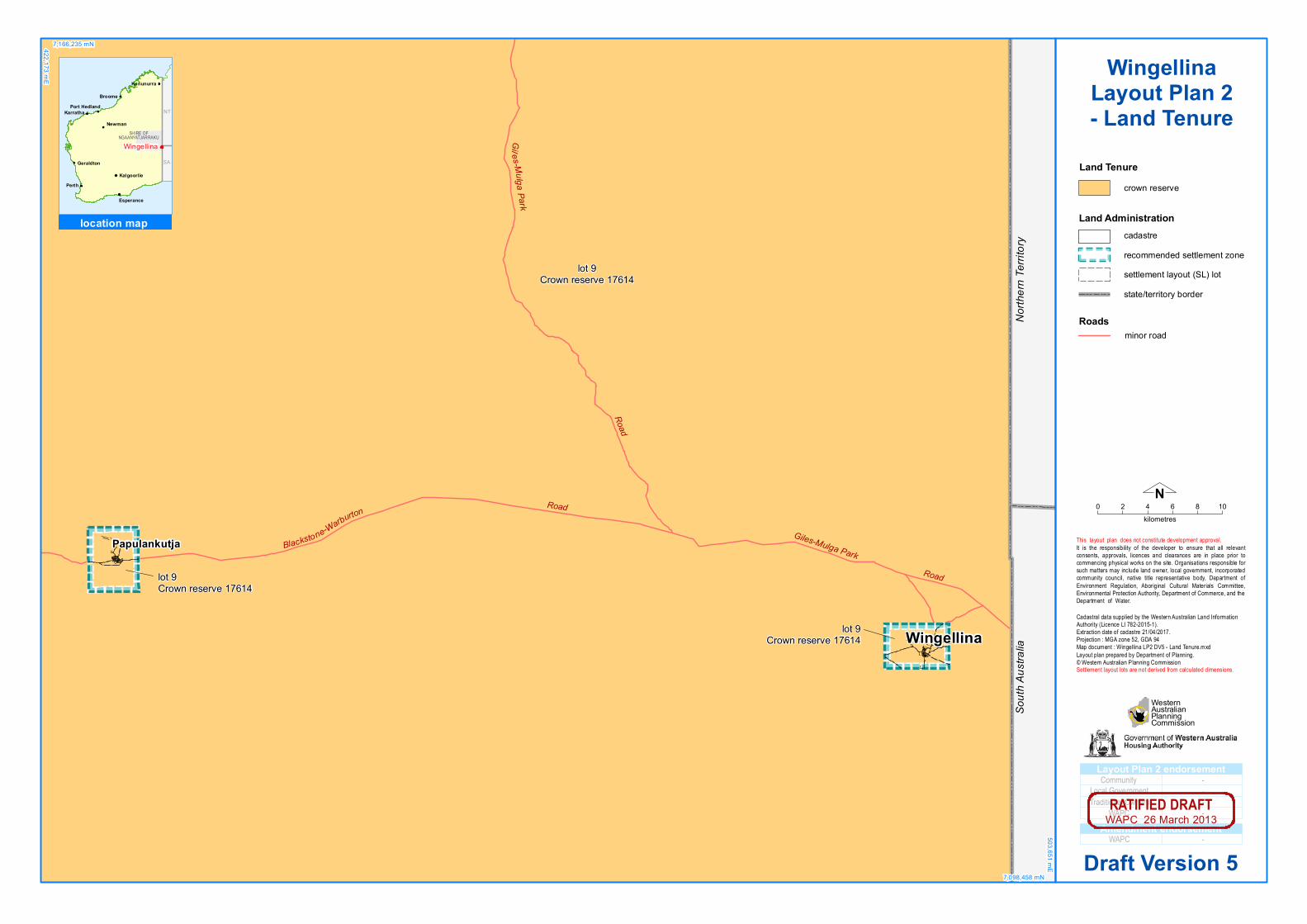
Land Tenurecrown reserve
Roadsminor road
Land Administrationcadastrerecommended settlement zonesettlement layout (SL) lotstate/territory border
lot 9Crown reserve 17614
lot 9Crown reserve 17614
lot 9Crown reserve 17614
Wingellina
Papulankutja Giles-Mulga Park
Road
Road
Giles-Mulg a Park
Road
Blackstone-Warburton
North
ern Te
rritory
South
Austr
alia
422,173 mE
7,166,235 mN
7,098,458 mN
503,651 mE
Perth
Broome
Karratha
Geraldton
Port Hedland
Kalgoorlie
Kununurra
NewmanAli ce
Sp rin gs
Esperance
NT
SA
location map
WingellinaSHIRE OFNGAANYATJARRAKU
WingellinaLayout Plan 2- Land Tenure
Draft Version 5