Embed Size (px)
Citation preview
Windle Island Junction Improvement Scheme
Full Business Case Environmental Impact Appraisal
June 2015
St Helens Metropolitan Borough Council

331738 WNE EVT 01 B
C:\Users\fol67979\Desktop\Windle Island Junction Improvement Scheme Environmental Impact Appraisal FBC Final for Client.docx
8 June 2015
Windle Island Junction Improvement Scheme
Full Business Case Environmental Impact Appraisal
Windle Island Junction Improvement Scheme
Full Business Case Environmental Impact Appraisal
June 2015
St Helens Metropolitan Borough Council
Wesley House, Corporation Street, St Helens, WA10 1HF
Mott MacDonald, Ground Floor West, 19A Canning Street, Edinburgh EH3 8EG, United Kingdom
T +44 (0)131 221 2300 F +44 (0)131 229 3735 W www.mottmac.com

331738/WNE/EVT/01/B 8 June 2015 C:\Users\fol67979\Desktop\Windle Island Junction Improvement Scheme Environmental Impact Appraisal FBC Final for Client.docx
Windle Island Junction Improvement Scheme Full Business Case Environmental Impact Appraisal
Revision Date Originator Checker Approver Description
A B
May 2015 June 2015
C Foley C Foley
A Craddy A Craddy
F Kilmurray F Kilmurray
First Draft for Internal Comment Final for Client Comment
Issue and revision record
Information Class: Standard
This document is issued for the party which commissioned it and for specific purposes connected with the above-captioned project only. It should not be relied upon by any other party or used for any other purpose.
We accept no responsibility for the consequences of this document being relied upon by any other party, or being used for any other purpose, or containing any error or omission which is due to an error or omission in data supplied to us by other parties.
This document contains confidential information and proprietary intellectual property. It should not be shown to other parties without consent from us and from the party which commissioned it.

331738/WNE/EVT/01/B 8 June 2015 C:\Users\fol67979\Desktop\Windle Island Junction Improvement Scheme Environmental Impact Appraisal FBC Final for Client.docx
Windle Island Junction Improvement Scheme Full Business Case Environmental Impact Appraisal
Chapter Title Page
Executive summary i
Abbreviations iv
1 Appraisal Outline 1
1.1 Introduction ________________________________________________________________________ 1 1.2 Project context _____________________________________________________________________ 1 1.3 Link between the Environmental Impact Appraisal and an Environmental Impact Assessment as part of
the planning process ________________________________________________________________ 1 1.4 Methodology _______________________________________________________________________ 2 1.5 Preliminary environmental appraisal and scoping __________________________________________ 3 1.6 Information sources _________________________________________________________________ 4 1.7 Appraisal assumptions and limitations ___________________________________________________ 5
2 Scheme Overview 7
2.1 Background _______________________________________________________________________ 7 2.2 Preferred Option ____________________________________________________________________ 7 2.3 Scheme location ____________________________________________________________________ 7 2.4 Need for the scheme ________________________________________________________________ 9
3 Noise 10
3.1 Introduction _______________________________________________________________________ 10 3.2 Appraisal methodology ______________________________________________________________ 10 3.3 Baseline _________________________________________________________________________ 11 3.4 Estimation of changes in noise impact __________________________________________________ 11 3.5 Consideration of the distributional impacts of changes in noise _______________________________ 11 3.6 Suggested mitigation measures and recommendations _____________________________________ 12
4 Air Quality 13
4.1 Introduction _______________________________________________________________________ 13 4.2 Appraisal methodology ______________________________________________________________ 15 4.3 Baseline _________________________________________________________________________ 15 4.4 Appraisal of local air quality impacts____________________________________________________ 19 4.5 Appraisal of regional air quality impacts _________________________________________________ 19 4.6 Consideration of the distributional impacts of changes in air quality ___________________________ 19 4.7 Suggested mitigation measures and recommendations _____________________________________ 19
5 Greenhouse Gases 20
5.1 Introduction _______________________________________________________________________ 20 5.2 Appraisal methodology ______________________________________________________________ 20 5.3 Baseline _________________________________________________________________________ 21
Contents
331738/WNE/EVT/01/B 8 June 2015 C:\Users\fol67979\Desktop\Windle Island Junction Improvement Scheme Environmental Impact Appraisal FBC Final for Client.docx
Windle Island Junction Improvement Scheme Full Business Case Environmental Impact Appraisal
5.4 Estimation of changes in energy consumption ____________________________________________ 21 5.5 Estimation of changes in emissions of greenhouse gases ___________________________________ 22 5.6 Suggested mitigation measures and recommendations _____________________________________ 23
6 Landscape 24
6.1 Introduction _______________________________________________________________________ 24 6.2 Methodology ______________________________________________________________________ 24 6.3 Scoping and identification of study area _________________________________________________ 24 6.4 Identifying key environmental resources and their features __________________________________ 24 6.5 Appraisal of environmental capital _____________________________________________________ 25 6.6 Appraisal of the proposal’s impact _____________________________________________________ 27 6.7 Overall assessment score ___________________________________________________________ 28 6.8 Suggested mitigation measures and recommendations _____________________________________ 28
7 Historic Environment 29
7.1 Introduction _______________________________________________________________________ 29 7.2 Methodology ______________________________________________________________________ 29 7.3 Scoping and identification of study area _________________________________________________ 29 7.4 Identifying key environmental resources and their features __________________________________ 30 7.5 Appraisal of Environmental Capital ____________________________________________________ 31 7.6 Appraisal of the proposal’s impact _____________________________________________________ 32 7.7 Overall assessment score ___________________________________________________________ 33 7.8 Suggested mitigation measures and recommendation ______________________________________ 33
8 Biodiversity 34
8.1 Introduction _______________________________________________________________________ 34 8.2 Methodology ______________________________________________________________________ 34 8.3 Scoping and identification of study area _________________________________________________ 34 8.4 Identifying key environmental resources and their features __________________________________ 34 8.5 Appraisal of environmental capital _____________________________________________________ 35 8.6 Appraisal of the proposal’s impact _____________________________________________________ 35 8.7 Overall assessment score ___________________________________________________________ 35 8.8 Suggested mitigation measures and recommendations _____________________________________ 36
9 Appraisal Summary Table 37
9.1 Overview ________________________________________________________________________ 37 9.2 Appraisal Summary Table ___________________________________________________________ 37
10 Conclusions 40
10.1 Summary of appraisal_______________________________________________________________ 40 10.2 Summary of likely environmental effects ________________________________________________ 40 10.3 Summary of guidance_______________________________________________________________ 40 10.4 Next steps _______________________________________________________________________ 40
i
331738/WNE/EVT/01/B 8 June 2015 C:\Users\fol67979\Desktop\Windle Island Junction Improvement Scheme Environmental Impact Appraisal FBC Final for Client.docx
Windle Island Junction Improvement Scheme Full Business Case Environmental Impact Appraisal
Mott MacDonald has been appointed by St Helens Metropolitan Borough Council (SHMBC) to support the
development of a Major Scheme Business Case for the proposed Windle Island Junction Improvement
Scheme on the A580 north of St Helens, Merseyside. The proposed scheme aims to improve congestion
and road safety at the junction by implementing additional traffic lanes and providing controlled crossings
for pedestrians and cyclists.
As part of both the Outline and Full Business Cases, an appraisal of the potential environmental effects
resulting from the preferred option has been undertaken, the findings of which are presented in this
document.
This environmental impact appraisal has been developed in line with Transport Analysis Guidance (TAG)
Unit A3: Environmental Impact Appraisal, November 2014) and has been undertaken in tandem with the
social and distributional appraisal to inform the development of the Full Business Case. The appraisal
considers the impacts (both positive and negative) of the design and development of the proposed Windle
Island Junction Improvements through the use of the eight environmental themes from TAG Unit A3.
These impacts have been appraised by relevant Mott MacDonald technical specialists and coordinated by
an environment specialist.
The effects of the scheme have been identified using a seven-point scale, in accordance with the TAG
criteria. The analysis used to identify the effect of the scheme on the environment is qualitative, not
quantitative (therefore the quantitative column in the table below is greyed out). This analysis serves as a
high-level environmental appraisal to understand the potential impacts of the scheme on the environment.
No further calculations were undertaken for noise, air quality and greenhouse gas as part of this appraisal.
The findings of the environmental appraisal are summarised in the Appraisal Summary Table provided
below:
Environmental Impact
Summary of impacts Quantitative Qualitative Monetary £
(NPV)*
Distributional/
7-pt scale
Noise
Impacts identified include noise increases associated with an increase in traffic flow and speed. This could be offset with mitigation in the form of acoustic barriers. Assuming appropriate noise mitigation measures are put into place, it is not anticipated that there will be any significant impacts of the scheme on noise. Therefore, the overall impact is neutral.
Neutral N/A 0
Air Quality (Local)
The Scheme aims to reduce congestion at the junction, which would be expected to improve air quality due to less idling vehicles and less very low speed traffic. Therefore, the overall impact of the Scheme is anticipated to be
Slight beneficial
N/A +
Executive summary
ii
331738/WNE/EVT/01/B 8 June 2015 C:\Users\fol67979\Desktop\Windle Island Junction Improvement Scheme Environmental Impact Appraisal FBC Final for Client.docx
Windle Island Junction Improvement Scheme Full Business Case Environmental Impact Appraisal
Environmental Impact
Summary of impacts Quantitative Qualitative Monetary £
(NPV)*
Distributional/
7-pt scale
slight beneficial.
Air Quality (Regional)
It is not anticipated that there will be a significant change to emissions of regional air pollutants as a result of the Scheme. Therefore, the overall impact is anticipated to be neutral.
Neutral N/A 0
Greenhouse Gases
The Scheme is likely to reduce congestion around the junction, which will lead to a reduction in fuel consumption. Therefore, the Scheme is anticipated to have a slight beneficial impact on greenhouse gas emissions.
Change in non-traded carbon over 60 years: unknown
Change in traded carbon over 60 years: unknown
N/A +
En
viron
men
tal C
ap
ita
l A
ppro
ach
Landscape
The Scheme is likely to cause a permanent loss of vegetation leading to a permanent change in landscape character, tranquillity and/or visibility of the road infrastructure.
The scheme is likely to cause an additional temporary loss of vegetation leading to a temporary change in landscape character, tranquillity and/or visibility of the road infrastructure.
The junction will become a more prominent feature in the landscape, leading to a permanent change in landscape character and/or visibility of the road infrastructure. However, overall, assuming appropriate mitigation is put into place, it is anticipated that there will be a neutral effect on the landscape.
Neutral N/A
0
Townscape Scoped out of this appraisal in favour of a landscape appraisal due to site setting.
Historic Environment
There may be the removal of archaeological remains through the installation of new highway and extensions to the existing highway. If encountered, this is likely to have a slight adverse impact
Slight adverse
N/A -
iii
331738/WNE/EVT/01/B 8 June 2015 C:\Users\fol67979\Desktop\Windle Island Junction Improvement Scheme Environmental Impact Appraisal FBC Final for Client.docx
Windle Island Junction Improvement Scheme Full Business Case Environmental Impact Appraisal
Environmental Impact
Summary of impacts Quantitative Qualitative Monetary £
(NPV)*
Distributional/
7-pt scale
on historic environment.
Biodiversity
Indirect impacts from noise and vibration on breeding birds between March and August in the ornamental hedgerow. Mitigated by works occurring outside March – August, being more than 5m away from the hedgerow or by a suitably qualified ecologist undertaking nesting bird checks between March to August. Overall, the scheme is anticipated to have a neutral impact on biodiversity.
Neutral N/A 0
Water Environment
Scoped out of the environmental appraisal, as there are no anticipated impacts on the water environment due to distance from water features.
iv
331738/WNE/EVT/01/B 8 June 2015 C:\Users\fol67979\Desktop\Windle Island Junction Improvement Scheme Environmental Impact Appraisal FBC Final for Client.docx
Windle Island Junction Improvement Scheme Full Business Case Environmental Impact Appraisal
Abbreviations Table
AADT Annual Average Daily Traffic
AAWT Annual Average Weekday Traffic
AQAP Air Quality Action Plan
AQMA Air Quality Management Area
AST Appraisal Summary Table
BAP Biodiversity Action Plan
CO2 Carbon Dioxide
dB Decibel
DECC Department of Energy and Climate Change
Defra Department for Environment, Food & Rural Affairs
DfT Department for Transport
DMRB Design Manual for Roads and Bridges
EA Environment Agency
EAR Economic Appraisal Report
EIA Environmental Impact Assessment
HER Historic Environment Record
HGV Heavy Goods Vehicle
JNCC Joint Nature Conservation Committee
Km Kilometre
ktCO2 Kilotonne of Carbon Dioxide
kWh Kilowatt-hour
LCR Liverpool City Region
LCR LTB Liverpool City Region Local Transport Body
MAGIC Multi Agency Geographic Information for the Countryside
MSBC Major Scheme Business Case
N/A Not Applicable
NO2 Nitrogen Dioxide
NPPF National Planning Policy Framework
OAR Options Appraisal Report
PCM Pollution Climate Mapping
SCOOT Split Cycle Offset Optimisation Technique
SHMBC St Helens Metropolitan Borough Council
SPZ Source Protection Zone
SSSI Site of Special Scientific Interest
TAG Transport Analysis Guidance
tCO2 Tonnes of CO2
TUBA Transport Users Benefit Appraisal
ZTV Zone of Theoretical Visibility
Abbreviations
Windle Island Junction Improvement Scheme Full Business Case Environmental Impact Appraisal
331738/WNE/EVT/01/B 8 June 2015 C:\Users\fol67979\Desktop\Windle Island Junction Improvement Scheme Environmental Impact Appraisal FBC Final for Client.docx
1
1.1 Introduction
The purpose of this document is to provide environmental input to the Full Business Case for the proposed
Windle Island Junction Improvement Scheme (herein after referred to as “the Scheme”). This document
will be presented as an appendix to the Full Business Case.
1.2 Project context
Mott MacDonald has been appointed by SHMBC to support the development of the Major Scheme
Business Case for proposed junction improvements at Windle Island Junction on the A580 north of St
Helens, Merseyside. The Scheme is one of a number of schemes that aims to improve transport
infrastructure in the Liverpool City Region (LCR). To inform the Full Business Case an appraisal of the
environment effects of the preferred scheme option has been undertaken in accordance with TAG (TAG
Unit A3: Environmental Impact Appraisal, November 2014). These impacts have been appraised
individually by relevant technical specialists, and coordinated by an environmental specialist.
As part of the Outline Business Case for the Scheme, a preliminary environmental appraisal was
undertaken in line with TAG (TAG Unit A3: Environmental Impact Appraisal, May 2014). This preliminary
environmental appraisal (331738SC03/WNE/EVT/01/B 30th September 2014) was undertaken in tandem
with the social and distributional appraisal, to inform the development of the Outline Business Case. The
environmental appraisal for the Outline Business Case provided a starting point for this full appraisal, and
identified the scope of the environmental issues for this project.
To inform the Full Business Case a high level appraisal of the environment effects of the Scheme has been
undertaken and has been appraised by relevant technical specialists. The review has been based upon the
design information within the Windle Island Options Appraisal Report (OAR), March 2014
(333896/ITD/ITN/01/A 12th March 2014).
1.3 Link between the Environmental Impact Appraisal and an Environmental
Impact Assessment as part of the planning process
The development of this environmental impact appraisal has been undertaken to inform the decision
making process for funding and as part of the Major Scheme Business Case (MSBC) submission. The
business case is developed in pursuit of funding approval. Once funding has been approved, if the
proposed transport infrastructure project is classified as a Schedule I project in line with the Environmental
Impact Assessment (EIA) (Town and Country Planning) Regulations 2011, an EIA will be undertaken as
part of a planning application. If the proposed project is classified a Schedule II project under the
aforementioned regulations, a screening letter is required to be submitted to the local planning authority to
identify whether or not an EIA should be undertaken.
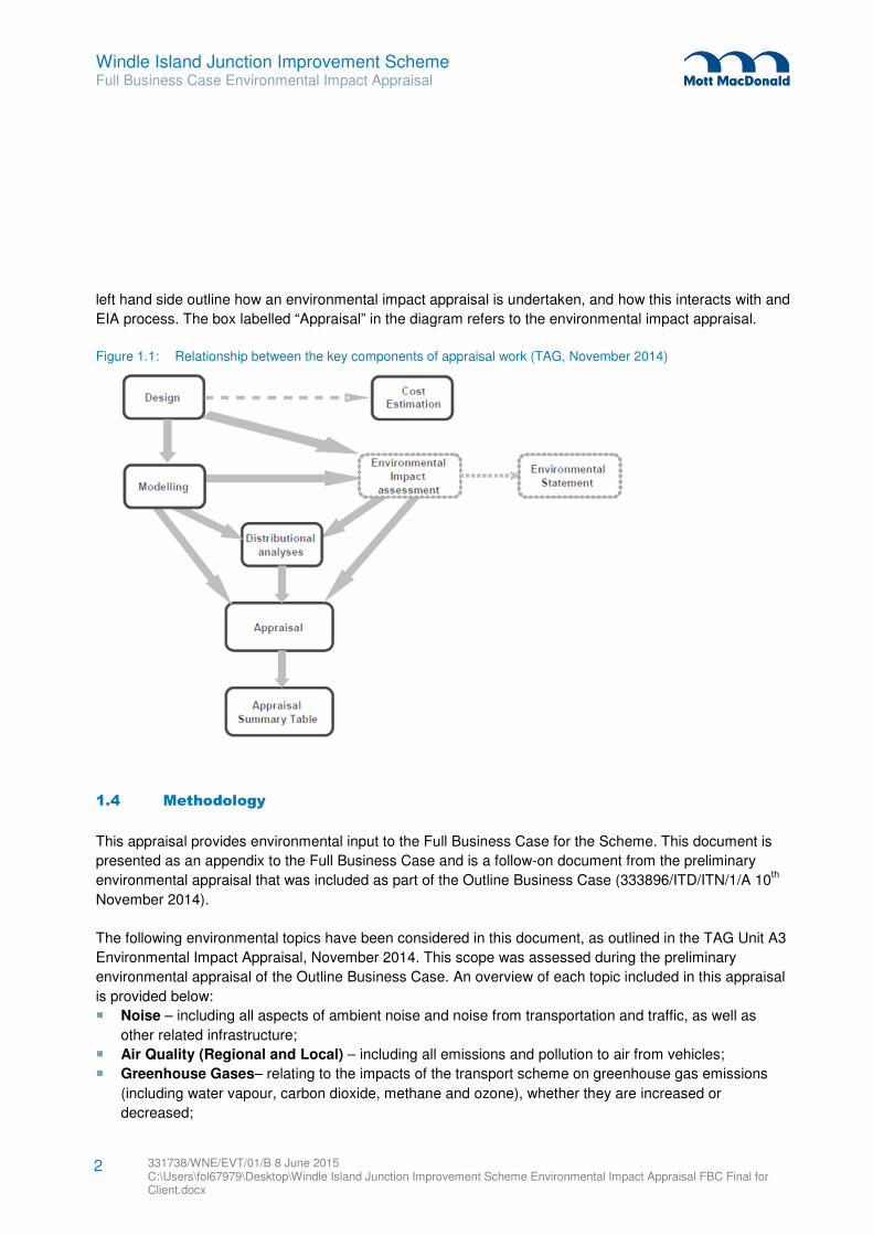
Figure 1.1 overleaf illustrates the relationship between the environmental impact appraisal included as part
of the business case and the EIA conducted to support an Environmental Statement. The steps down the
1 Appraisal Outline
Windle Island Junction Improvement Scheme Full Business Case Environmental Impact Appraisal
331738/WNE/EVT/01/B 8 June 2015 C:\Users\fol67979\Desktop\Windle Island Junction Improvement Scheme Environmental Impact Appraisal FBC Final for Client.docx
2
left hand side outline how an environmental impact appraisal is undertaken, and how this interacts with and
EIA process. The box labelled “Appraisal” in the diagram refers to the environmental impact appraisal.
Figure 1.1: Relationship between the key components of appraisal work (TAG, November 2014)
1.4 Methodology
This appraisal provides environmental input to the Full Business Case for the Scheme. This document is
presented as an appendix to the Full Business Case and is a follow-on document from the preliminary
environmental appraisal that was included as part of the Outline Business Case (333896/ITD/ITN/1/A 10th
November 2014).
The following environmental topics have been considered in this document, as outlined in the TAG Unit A3
Environmental Impact Appraisal, November 2014. This scope was assessed during the preliminary
environmental appraisal of the Outline Business Case. An overview of each topic included in this appraisal
is provided below:
� Noise – including all aspects of ambient noise and noise from transportation and traffic, as well as
other related infrastructure;
� Air Quality (Regional and Local) – including all emissions and pollution to air from vehicles;
� Greenhouse Gases– relating to the impacts of the transport scheme on greenhouse gas emissions
(including water vapour, carbon dioxide, methane and ozone), whether they are increased or
decreased;
Windle Island Junction Improvement Scheme Full Business Case Environmental Impact Appraisal
331738/WNE/EVT/01/B 8 June 2015 C:\Users\fol67979\Desktop\Windle Island Junction Improvement Scheme Environmental Impact Appraisal FBC Final for Client.docx
3
� Townscape or Landscape –referring to the physical and social characteristics of the urban or rural
environment and the way in which these characteristics are perceived;
� Historic Environment–including historical and cultural buildings, assets and archaeological sites and
areas such as parks, gardens and public spaces;
� Biodiversity–including earth heritage (geological) interests, flora and fauna; and
� Water Environment–relating to all aspects of the water environment, including groundwater and
surface water and aquatic ecology.
As part of the outline business case, a scoping exercise was undertaken of the eight environmental topics
to be assessed. The baseline conditions and the potential impact of the proposed scheme were
considered. At this stage, where there is no predicted impact on an environmental topic, it may be scoped
out as a result. The topics that have been scoped out of this appraisal are discussed in Section 1.5.
In analysing the environmental impacts of the scheme, there are two categories of impacts:
� Those that arise as a result of changes in traffic (either road or rail) or transport infrastructure, e.g.
noise, air pollution and greenhouse gases; and
� Those that arise in the surrounding area as a result of new or improved transport infrastructure, e.g.
landscape, townscape, biodiversity, heritage and the water environment.
Each environmental topic has been given its own chapter within this report, which has been completed by
a relevant technical specialist, and coordinated by an environmental specialist. All appraisals assume
mitigation measures will be applied. Due to the size of the project, a proportionate approach has been
taken; this includes only undertaking qualitative analysis and no TAG worksheets have been included as
part of this appraisal. All relevant information has been included in each technical specialist chapter, apart
from the assumptions included in Section 1.7.
1.5 Preliminary environmental appraisal and scoping
To inform the development of the Outline Business Case for the Scheme, a preliminary environmental
appraisal was undertaken in September 2014, and was carried out in parallel with the social and
distributional appraisal. The document was developed in line with TAG (TAG Unit A3: Environmental
Impact Appraisal, May 2014) and was written to be included as an appendix to the Outline Business Case
for major transport scheme funding. The TAG Unit A3: Environmental Impact Appraisal guidance has been
updated since the Outline Business Case was submitted in October 2014. A gap analysis was undertaken
between the difference in the two revisions of the guidance documents, and no significant changes have
been observed.
The preliminary environmental appraisal comprised of two sections:
� A high level scoping exercise that details the proposed scheme and provides an environmental
baseline; and
� The preliminary Appraisal Summary Table (AST).
Windle Island Junction Improvement Scheme Full Business Case Environmental Impact Appraisal
331738/WNE/EVT/01/B 8 June 2015 C:\Users\fol67979\Desktop\Windle Island Junction Improvement Scheme Environmental Impact Appraisal FBC Final for Client.docx
4
To inform the scoping exercise, a review of the MAGIC website, Natural England website, English
Heritage’s Heritage Protection Database and other relevant sources was undertaken to develop a baseline
for each of the eight environmental topics outlined by TAG (see Section 1.4). Due to the potential impacts
outlined in the baseline exercise, it was recommended that seven out of the eight environmental topics
were considered further for the Full Business Case.
The preliminary AST identified the potential effects of the scheme on the eight environmental topics, using
the seven-point scale system outlined in Table 9.1. The analysis used to identify the effect of the Scheme
on the environment was qualitative, not quantitative and was based on publicly available information,
available at the time of writing. This analysis served as an environmental appraisal to understand the
general impacts of the potential schemes on the environment. The preliminary AST identified a potential
slight adverse impact to noise, landscape and biodiversity, and a slight beneficial impact to local and
regional air quality as well as greenhouse gases. The proposed works were appraised to have a likely
neutral impact on townscape and historic environment.
Water environment was scoped out of the preliminary environmental impact appraisal, as the Scheme is
unlikely to impact the local water environment. Windle Island is not located within a groundwater Source
Protection Zone (SPZ), nor is it located within a Flood Zone. There are also no rivers, lakes or bodies of
water within 500m of the Scheme. Therefore, water environment has not been included in this
environmental impact appraisal.
Following TAG, either Landscape or Townscape issues are assessed for each project. Townscape has
been scoped out of the appraisal at this stage, in favour of a landscape appraisal. As the junction is in a
predominantly rural area, there are no significant and relevant townscape issues to assess for this
particular Scheme. It is therefore appropriate that a landscape assessment is undertaken for this area, in
line with TAG, November 2014.
The following chapters in this Environmental Impact Appraisal are informed by the preliminary
environmental impact appraisal and aim to update the AST to provide a detailed environmental
assessment for each of the environmental topics scoped in to the appraisal. The full AST can be found in
Table 9.2.
1.6 Information sources
The following sources and documents have been reviewed in preparation of this document:
� Windle Island Economic Appraisal Report (EAR),October 2014 (331738/ITN/ITD/001/A);
� Windle Island Options Appraisal Report (OAR), March 2014 (333896/ITD/ITN/01/A 12 March 2014);
� Multi Agency Geographic Information for the Countryside (MAGIC) Website;
� Environment Agency (EA) website;
� Natural England website;
� TAG Unit A3: Environmental Impact Appraisal, November 2014;
� UK Department of Energy and Climate Change (DECC) Greenhouse Gas Emissions Report for Local
Authorities (2014);
Windle Island Junction Improvement Scheme Full Business Case Environmental Impact Appraisal
331738/WNE/EVT/01/B 8 June 2015 C:\Users\fol67979\Desktop\Windle Island Junction Improvement Scheme Environmental Impact Appraisal FBC Final for Client.docx
5
� EU Directive 2008/50/EEC on Ambient Air Quality and Cleaner Air for Europe;
� The Air Quality Standards Regulations 2010;
� Air Quality (England) Regulations 2000;
� Department for Environment, Food & Rural Affairs (Defra) Pollution Climate Mapping (PCM) model;
� SHMBC Air Quality Action Plan (AQAP), March 2013;
� National Planning Policy Framework (NPPF) 2012, Annex 2 Glossary;
� Joint Nature Conservation Committee (JNCC) Phase 1 Habitat Survey Methodology (2010);
� Heritage Gateway;
� Archaeological Data Service;
� English Heritage’s National Heritage List for England;
� Historic England Pastscape;
� Oldmaps.com; and
� Merseyside Historic Environment Record (HER).
1.7 Appraisal assumptions and limitations
The following sections identify the assumptions and limitations experienced during the preparation of this
environmental impact appraisal.
1.7.1 Noise
The following assumptions and limitations relate to the noise assessment:
� No site visits were undertaken for this assessment, and it has only been a desk-based appraisal;
� It is assumed that appropriate noise mitigation measures will be put into place as part of the
construction and operation of the scheme;
� It is assumed that scheme design and traffic forecasts remain unchanged; and
� This appraisal is qualitative, not quantitative, which means that the anticipated impacts have not been
based upon calculated noise changes arising from the scheme.
1.7.2 Air Quality and Greenhouse Gases
The following assumptions and limitations relate to the air quality and greenhouse gas assessments:
� This appraisal presents changes in the value of greenhouse gas emissions which were calculated as
part of the EAR (October 2014). As a result, the modelling assumptions contained in the EAR are also
incorporated in this appraisal; and
� The transport modelling which was undertaken as part of the EAR only considered changes in vehicle-
kilometres (km) but not vehicle speeds. As a result, it was not possible to derive fuel consumption in
litres or electricity usage in kilowatt-hour (kWh) from the available data. This meant that it was not
possible to calculate emissions of greenhouse gases in units of tCO2. The economic valuation of
emissions, calculated using a TAG methodology, was reported instead.
1.7.3 Landscape
The following assumptions and limitations relate to the landscape assessment:
� A Zone of Theoretical Visibility (ZTV) has not been determined due to the high level, desk based nature
of this assessment;
Windle Island Junction Improvement Scheme Full Business Case Environmental Impact Appraisal
331738/WNE/EVT/01/B 8 June 2015 C:\Users\fol67979\Desktop\Windle Island Junction Improvement Scheme Environmental Impact Appraisal FBC Final for Client.docx
6
� Visual effects are described for groups of receptors and the worst case effects identified. Not all
individual receptors within the group would necessarily experience the same effects and so the
assessment is precautionary;
� It is assumed that the existing vegetation identified as providing screening will still exist during the
construction and operation phases of the scheme (unless clearly lost as a result of the proposed
scheme); and
� It is assumed that the construction of the proposed development can be completed within the footprint
identified by the brief.
1.7.4 Historic Environment
The following assumptions and limitations relate to the historic environment assessment:
� No site visits were undertaken and as such the specialists have no knowledge of whether there are
extant (structures or earthworks) heritage assets at the sites or the extent of ground disturbance
caused by the construction of the East Lancashire Road;
� As no site visits were undertaken, it has not been possible to carry out a detailed assessment of the
significance or setting of any heritage assets in the vicinity of the development area;
� The assessment has been made on the basis of freely available information. There are inherent
inaccuracies in this data, particularly in terms of date and location of heritage assets and there could be
additional records for the area which have not been made accessible; and
� The exact nature, extent, date, degree of preservation and significance of known and potential
archaeological remains can be difficult to accurately predict from desk-based studies alone. The
uncertainty in predicting impacts and effects upon such resources is inherent in all such studies and
should be stressed.
1.7.5 Biodiversity
The following assumptions and limitations relate to the biodiversity assessment:
� It has been assumed that appropriate mitigation measures will be put in place to minimise the potential
impacts on environmental resources, and this is reflected in the appraisals already given; and
� No protected species surveys have been undertaken and no records have been requested from the
local records centre, therefore this assessment has been based upon a desk study and one site visit.
1.7.6 Report structure
This environmental impact appraisal comprises the following:
� Overview of the scheme (Chapter 2);
� Individual chapters for each impact area (in line with TAG): Noise, Air Quality, Greenhouse Gases,
Townscape, Historic Environment, and Biodiversity (Chapters 3-8). These chapters provide a baseline
for each issue, as well as an environmental appraisal, provided by a relevant technical specialist;
� Appraisal Summary Table (AST) (Chapter 9); and
� Conclusions (Chapter 10).
Windle Island Junction Improvement Scheme Full Business Case Environmental Impact Appraisal
331738/WNE/EVT/01/B 8 June 2015 C:\Users\fol67979\Desktop\Windle Island Junction Improvement Scheme Environmental Impact Appraisal FBC Final for Client.docx
7
2.1 Background
The A580/A570 intersection (Windle Island) improvement scheme was submitted by St. Helens
Metropolitan Borough Council to the Liverpool City Region Local Transport Body (LCR LTB) in April 2013
as the first step in the process for accessing major transport scheme funding for the period 2015/16-
2018/19. Following prioritisation, the Scheme, which seeks to address current severe congestion, safety
and network resilience issues at Windle Island, was ranked twelfth in the shortlist of major schemes across
the LCR.
An assessment has been undertaken by Mott MacDonald on options to improve congestion and road
safety at Windle Island.
2.2 Preferred Option
Following the options appraisal, the proposed Scheme:
� Provides controlled pedestrian crossings on all arms of the intersection;
� Provides toucan crossings on the A580 East and A570 South arms;
� Widens existing pedestrian crossing refuges at the Windle Island;
� Widens the A580 East arm to allow the provision of an additional right turn flare on the A580
westbound carriageway;
� Widens the A570 North arm to allow the provision of an additional left turn flare on the A570
southbound carriageway;
� Lengthens the existing right turn flare on the A580 West arm;
� Widens the central reserve along the A580 in the vicinity of the intersection to allow the extension of
the vehicle restraint barrier through the intersection;
� Upgrades the existing intelligent transport facilities to include increased CCTV coverage and variable
message signs.
The Scheme seeks to improve pedestrian, cyclist and vehicular road safety at Windle Island and will
alleviate congestion during the AM and PM peaks. The improvements will also reduce the severe
congestion experienced when the Tactical Diversion Route is in operation.
This is the preferred option for the scheme, which will be appraised in this environmental impact appraisal.
2.3 Scheme location
Windle Island is located at the intersection of the A580 and the A570, approximately 1 km northeast of the
village of Windle and approximately 2.5km northwest of St Helens city centre. It is an important intersection
on the LCR road network, located close to the borough’s boundary with Knowsley, and central to the M57,
M58, M6 and M62.
Windle Island forms a vital link for routes accessing key sites such as Liverpool City Centre, Warrington,
Wigan, Widnes, Runcorn, Manchester, Kings Business Park, Superport and the proposed Parkside Rail
Freight Interchange.
2 Scheme Overview
Windle Island Junction Improvement Scheme Full Business Case Environmental Impact Appraisal
331738/WNE/EVT/01/B 8 June 2015 C:\Users\fol67979\Desktop\Windle Island Junction Improvement Scheme Environmental Impact Appraisal FBC Final for Client.docx
8
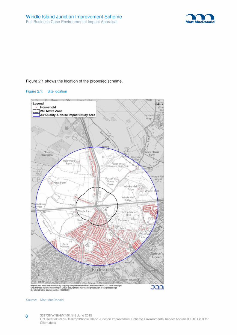
Figure 2.1 shows the location of the proposed scheme.
Figure 2.1: Site location
Source: Mott MacDonald
Windle Island Junction Improvement Scheme Full Business Case Environmental Impact Appraisal
331738/WNE/EVT/01/B 8 June 2015 C:\Users\fol67979\Desktop\Windle Island Junction Improvement Scheme Environmental Impact Appraisal FBC Final for Client.docx
9
2.4 Need for the scheme
As part of the appraisal process it is important to understand the need for the scheme in the wider context.
Below is an extract from the business case document on the need for the scheme.
The Windle Island junction is a key strategic point in the LCR road network, as the A580 East Lancashire
Road is one of the main routes inKnowsley and connects Liverpool with Manchester. The A570 is a
strategic regional north/south corridor. Windle Island is currently operating at capacity, leading to traffic
congestion for road users during peak periods. The Scheme is identified within the third Local Transport
Plan for Merseyside and is part of the Strategic Freight Network for Merseyside.
Windle Island has been identified as a ‘High Risk Site’ within SHMBC’s Annual Road Safety Plan. The
residential area of Windle bounds the Windle Island junction to the south. Over the last 5 years (2008-
2013), 23 accidents were recorded, resulting in 46 casualties. Provision of better facilities for the
pedestrians and cyclists in this location would improve safety for the more vulnerable road users.
Windle Island also acts as a major congestion pinch point on the local and strategic road network, as it is
bound by 4 motorways (M57 to the west, M58 to the north, M6 to the east and M62 to the south).
Therefore, improvements to junction operation at Windle Island seek to address resilience issues relating
to the strategic road network.

Windle Island Junction Improvement Scheme Full Business Case Environmental Impact Appraisal
331738/WNE/EVT/01/B 8 June 2015 C:\Users\fol67979\Desktop\Windle Island Junction Improvement Scheme Environmental Impact Appraisal FBC Final for Client.docx
10
3.1 Introduction
This chapter provides a qualitative, desk-based review of the preferred option for the Scheme, with respect
to the WebTAG appraisal method for noise. The most recent version of the appraisal methodology (TAG
Unit A3) was issued in November 2014.
The OAR for St Helens Metropolitan Borough Council dated March 2014, considered three options –
option 1 (Do nothing), Option 2 (a combination of measures to facilitate right-hand turns), and Option 3 (as
Option 2, but with an carriageway modification to accommodate an additional left turn lane on the A570
north). This chapter considers Option 3, the preferred scheme.
3.2 Appraisal methodology
TAG Unit A3 notes in paragraph 2.1.2 that:
“It should be recognised that, in many situation, relatively large changes in traffic flows are required to
bring about significant changes in the response to noise levels in the long term. For freely flowing traffic, a
difference of about 3 decibel (dB) in noise level is required before there is a statistically significant change
in the average assessment of nuisance. However there are situations where this is not the case, as even a
1dB change in noise can affect the nuisance, as a result of the variation in traffic composition or flow, the
introduction of a new noise source, or if the change occurs suddenly. When options of this nature are being
appraised, the analyst will need to exercise judgement about whether the impact on noise should be
scoped out (see below). Furthermore, care is needed in assessing options which may result in adverse
noise impacts during the night.”
Paragraph 2.2.2 notes:
“…The noise appraisal should be proportional to the scheme and its proposed impact. Analysis should be
no more detailed than is required to support robust decision making. The analyses outlined in this Unit may
not be appropriate for all schemes, but should provide the basis for less detailed analyses where
appropriate...”
For the purpose of this appraisal a desktop exercise has been undertaken into establishing likely effects
based on scheme proposals, vicinity of residential receptors and likely existing background noise taking
the above advice into account. The qualitative assessment does not take into account additional traffic
facilitated by junction improvements and future development. The WebTAG appraisal methodology relies
on assessment methodology within Volume 11, Section 3, Part 7: ‘Noise and Vibration’ of the Design
Manual for Roads and Bridges. This in turn relies on LA10,18hour traffic flows. In the interests of
proportionality, a qualitative appraisal is undertaken.
3 Noise
Windle Island Junction Improvement Scheme Full Business Case Environmental Impact Appraisal
331738/WNE/EVT/01/B 8 June 2015 C:\Users\fol67979\Desktop\Windle Island Junction Improvement Scheme Environmental Impact Appraisal FBC Final for Client.docx
11
3.3 Baseline
Windle Island falls within the borough of St Helens and is a signal controlled junction with attendant
congestion and queuing issues. There are houses immediately adjacent to the junction, to the north-west
and south-west. The A580, running east and west of the junction, connects with the M57 to the east and
with the M6 to the west. The A570 running north and south of the junction, connects with the M58 to the
north and the M62 to the south. Both the A580 and A570 form part of the tactical diversion route when
incidents occur on the motorway network. Thus traffic noise associated with free-flowing and congested
traffic is likely to be a constant feature of the background noise climate.
3.4 Estimation of changes in noise impact
The OAR identified the following effect of each option on traffic:
� Option 1 - Do nothing, worsening in queuing;
� Option 2 – reduction in vehicle delay and increase in capacity; and
� Option 3 - reduction in vehicle delay and increase in capacity with additional capacity being sufficient to
alleviate congestion when the tactical diversion route is in operation.
In order to achieve an increase of 1dB, in broad terms, a traffic increase of 25% is necessary. Similarly, in
order to achieve an increase of 3dB, a doubling of traffic would need to occur. Alternatively, noise changes
could also occur as a result of significant changes in flow parameters such as speed and percentage HGV
etc. Traffic noise is assessed and appraised in terms of the Annual Average Weekday Traffic (AAWT)
across an 18-hour period (06:00 – 24:00). This period includes both off-peak and peak periods.
Option 3 would result in an improvement in congestion thus altering the traffic flow parameters which in
turn could give rise to noise changes. However, it is considered unlikely that changes of sufficient
magnitude to cause noise changes of as much as 3dB in the vicinity of Windle Island would occur as a
result of the scheme. This is due to the fact that the appraisal methodology requires AAWT flows (i.e.
averaged across an 18-hour period), thus the effect of congestion relief would be small in noise terms
(although there may be noticeable short- term changes).
An influencing factor may also be the proposed use of high-friction surfacing. This type of surfacing may
also give rise to localised increases in noise, particularly taken in context with the reduction in congestion
and thus higher average speed.
3.5 Consideration of the distributional impacts of changes in noise
Taking into account the reduction in congestion and increase in capacity there is the potential to be noise
impacts on the A570 and A580 further afield, associated with any changes in speed or volume of traffic.
However, taking into account changes in traffic necessary to bring about noise changes, it is considered
these are not likely to be of sufficient magnitude to generate anything other than minor changes in noise
level.
Windle Island Junction Improvement Scheme Full Business Case Environmental Impact Appraisal
331738/WNE/EVT/01/B 8 June 2015 C:\Users\fol67979\Desktop\Windle Island Junction Improvement Scheme Environmental Impact Appraisal FBC Final for Client.docx
12
3.6 Suggested mitigation measures and recommendations
It is recommended mitigation in the form of acoustic barriers be incorporated into the scheme design.
These would offset any increases associated with the scheme, and with suitable design may improve the
acoustic environment over existing noise levels (depending on extent and height of barrier). Clearly the
closest properties to the scheme are worst-affected in terms of existing noise and would benefit most from
the introduction of barriers, but properties further afield could also benefit.
The above conclusions have been based upon a desk-based qualitative assessment and it is
recommended that acoustic modelling be used to quantify findings.
Windle Island Junction Improvement Scheme Full Business Case Environmental Impact Appraisal
331738/WNE/EVT/01/B 8 June 2015 C:\Users\fol67979\Desktop\Windle Island Junction Improvement Scheme Environmental Impact Appraisal FBC Final for Client.docx
13
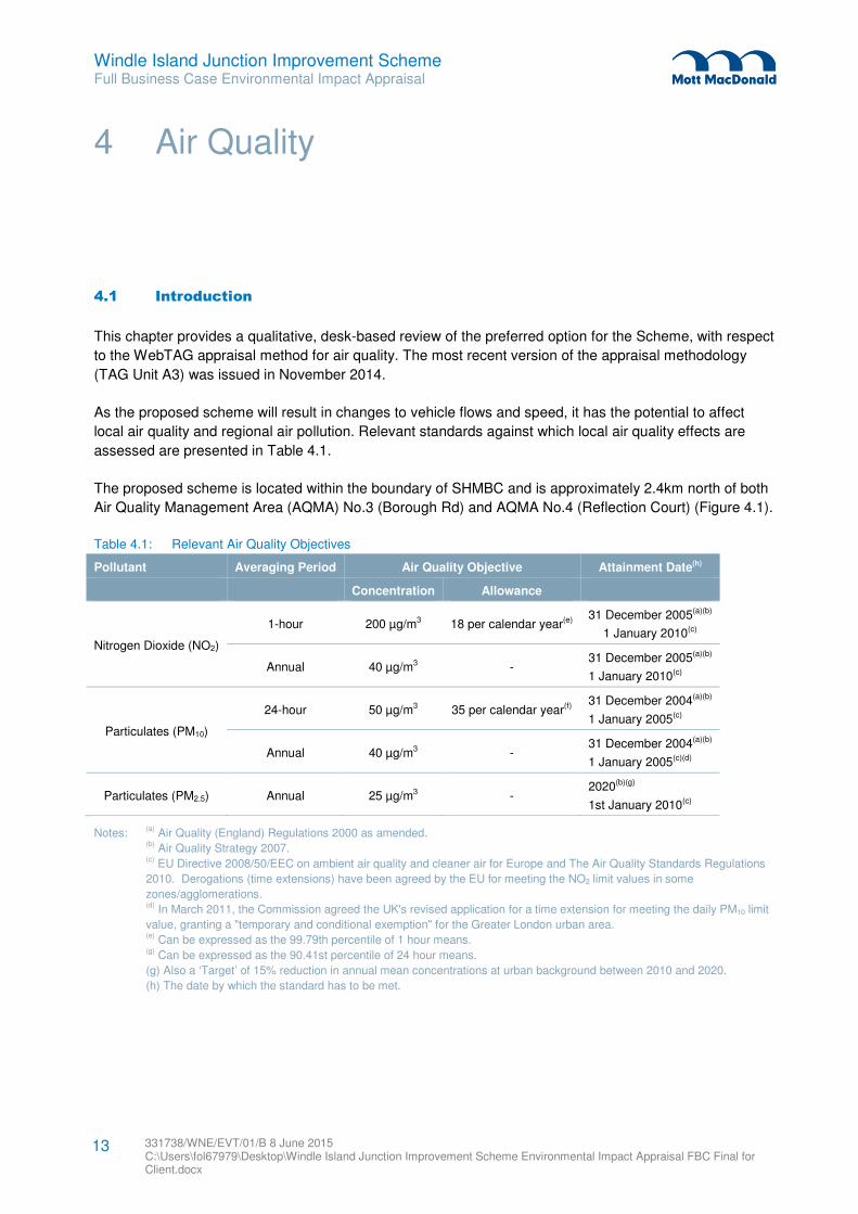
4.1 Introduction
This chapter provides a qualitative, desk-based review of the preferred option for the Scheme, with respect
to the WebTAG appraisal method for air quality. The most recent version of the appraisal methodology
(TAG Unit A3) was issued in November 2014.
As the proposed scheme will result in changes to vehicle flows and speed, it has the potential to affect
local air quality and regional air pollution. Relevant standards against which local air quality effects are
assessed are presented in Table 4.1.
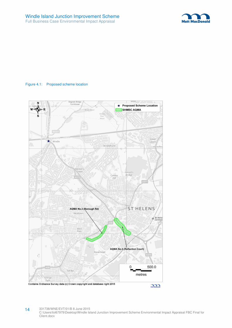
The proposed scheme is located within the boundary of SHMBC and is approximately 2.4km north of both
Air Quality Management Area (AQMA) No.3 (Borough Rd) and AQMA No.4 (Reflection Court) (Figure 4.1).
Table 4.1: Relevant Air Quality Objectives
Pollutant Averaging Period Air Quality Objective Attainment Date(h)
Concentration Allowance
Nitrogen Dioxide (NO2)
1-hour 200 µg/m3 18 per calendar year(e) 31 December 2005(a)(b)
1 January 2010(c)
Annual 40 µg/m3 - 31 December 2005(a)(b)
1 January 2010(c)
Particulates (PM10)
24-hour 50 µg/m3 35 per calendar year(f) 31 December 2004(a)(b)
1 January 2005(c)
Annual 40 µg/m3 - 31 December 2004(a)(b)
1 January 2005(c)(d)
Particulates (PM2.5) Annual 25 µg/m3 - 2020(b)(g)
1st January 2010(c)
Notes: (a)
Air Quality (England) Regulations 2000 as amended. (b)
Air Quality Strategy 2007. (c)
EU Directive 2008/50/EEC on ambient air quality and cleaner air for Europe and The Air Quality Standards Regulations
2010. Derogations (time extensions) have been agreed by the EU for meeting the NO2 limit values in some
zones/agglomerations.
(d)
In March 2011, the Commission agreed the UK's revised application for a time extension for meeting the daily PM10 limit
value, granting a "temporary and conditional exemption" for the Greater London urban area.
(e)
Can be expressed as the 99.79th percentile of 1 hour means.
(g)
Can be expressed as the 90.41st percentile of 24 hour means.
(g) Also a ‘Target’ of 15% reduction in annual mean concentrations at urban background between 2010 and 2020.
(h) The date by which the standard has to be met.
4 Air Quality
Windle Island Junction Improvement Scheme Full Business Case Environmental Impact Appraisal
331738/WNE/EVT/01/B 8 June 2015 C:\Users\fol67979\Desktop\Windle Island Junction Improvement Scheme Environmental Impact Appraisal FBC Final for Client.docx
14
Figure 4.1: Proposed scheme location
Windle Island Junction Improvement Scheme Full Business Case Environmental Impact Appraisal
331738/WNE/EVT/01/B 8 June 2015 C:\Users\fol67979\Desktop\Windle Island Junction Improvement Scheme Environmental Impact Appraisal FBC Final for Client.docx
15
4.2 Appraisal methodology
This assessment follows the methodology described in the latest WebTAG guidance. However, because
information on current and future traffic flows is limited, a qualitative approach has been used. Key
elements of the assessment are:
� A review of existing information on baseline air quality within the area;
� Description of potential local air quality impacts; and
� Description of potential regional air pollution impacts.
4.3 Baseline
4.3.1 Overview
Information on air quality in the UK can be obtained from a variety of sources including Local Authorities,
national network monitoring sites and other published sources. For the purposes of this assessment, data
has been obtained from SHMBC and Defra’s PCM model. The most recent monitoring data available from
SHMBC is for 2013.
4.3.2 Local Authority review and assessment
SHMBC undertook its first round of Review and Assessment in 1999, concluding that all pollutants were
meeting all their respective air quality objectives. The third round of Review and Assessment, carried out in
2008, identified exceedances of the NO2 annual mean objective. Following a detailed assessment, AQMA
1 and 2 were declared in April 2009 for exceedances of the NO2 annual mean objective. AQMA 1 and 2
are both over 8km east of the proposed scheme location and are not expected to be significantly affected
by the scheme. They are therefore not discussed further in this chapter.
The fourth round of Review and Assessment in 2011 identified a further five locations exceeding the NO2
annual mean objective. Following a detailed assessment, AQMA 3 and 4 were declared in November 2011
for exceedances of the NO2 annual mean objective.
SHMBC released its latest Progress Report in 2014, which concluded there was no need to progress to a
Detailed Assessment as all pollutants were meeting their respective air quality objectives outside of
existing AQMAs.
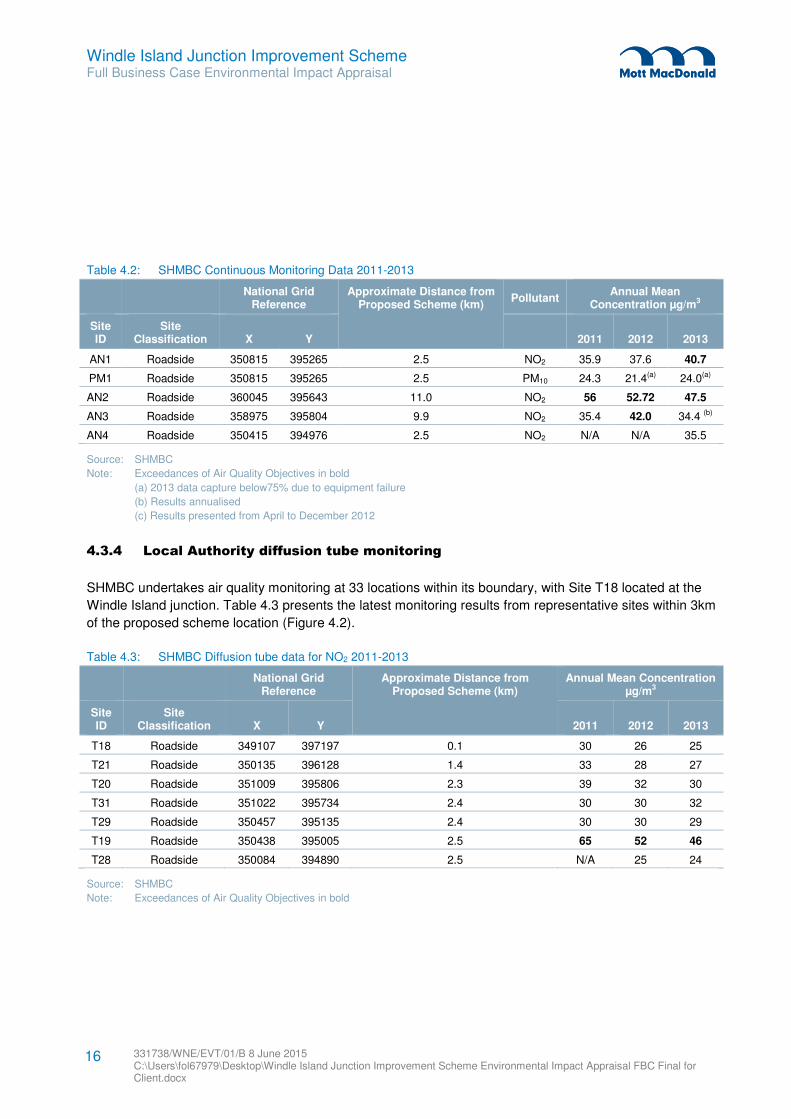
4.3.3 Local Authority automatic monitoring
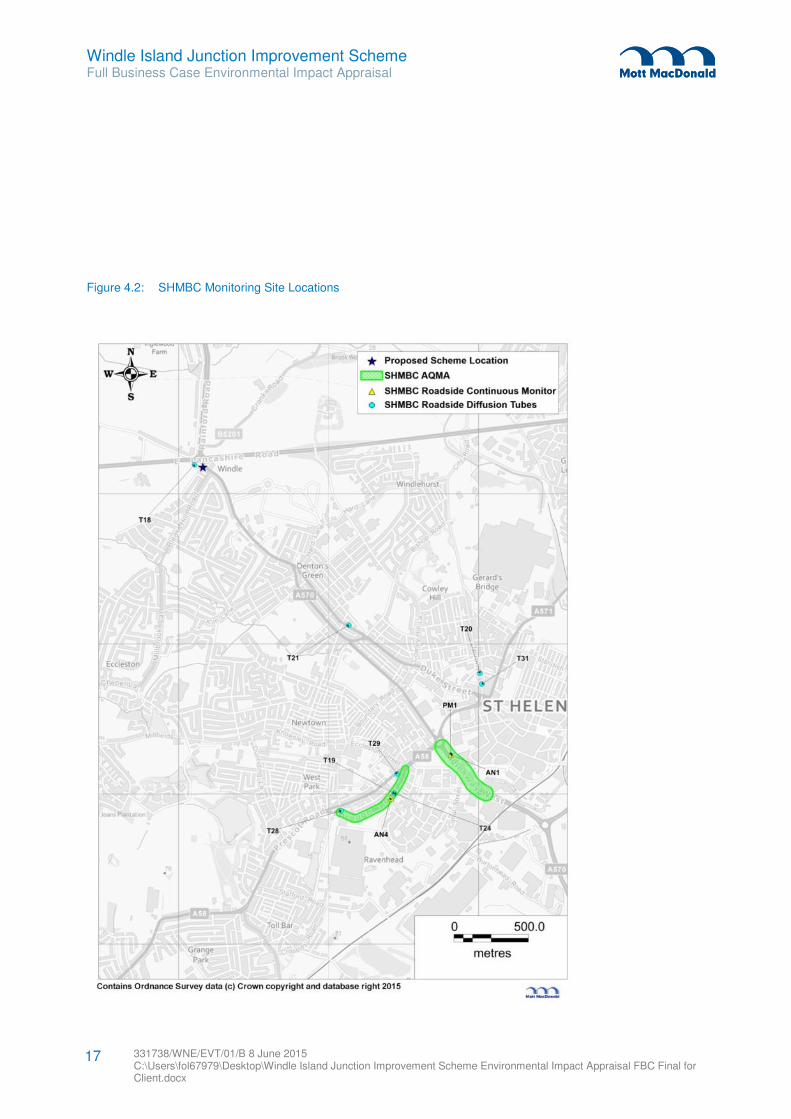
SHMBC undertakes air quality monitoring at four automatic monitoring stations within its boundary, all of
these stations are classified as “roadside”. Two of the stations are approximately 2.5km from the proposed
scheme location; the other two sites are located over 9km away from the proposed scheme location. Table
4.2 presents the latest automatic monitoring results for these stations, with Figure 4.2 showing the location
of stations within 3km.
Windle Island Junction Improvement Scheme Full Business Case Environmental Impact Appraisal
331738/WNE/EVT/01/B 8 June 2015 C:\Users\fol67979\Desktop\Windle Island Junction Improvement Scheme Environmental Impact Appraisal FBC Final for Client.docx
16
Table 4.2: SHMBC Continuous Monitoring Data 2011-2013
National Grid Reference
Approximate Distance from Proposed Scheme (km)
Pollutant Annual Mean
Concentration µg/m3
Site ID
Site Classification X Y 2011 2012 2013
AN1 Roadside 350815 395265 2.5 NO2 35.9 37.6 40.7
PM1 Roadside 350815 395265 2.5 PM10 24.3 21.4(a) 24.0(a)
AN2 Roadside 360045 395643 11.0 NO2 56 52.72 47.5
AN3 Roadside 358975 395804 9.9 NO2 35.4 42.0 34.4 (b)
AN4 Roadside 350415 394976 2.5 NO2 N/A N/A 35.5
Source: SHMBC
Note: Exceedances of Air Quality Objectives in bold
(a) 2013 data capture below75% due to equipment failure
(b) Results annualised
(c) Results presented from April to December 2012
4.3.4 Local Authority diffusion tube monitoring
SHMBC undertakes air quality monitoring at 33 locations within its boundary, with Site T18 located at the
Windle Island junction. Table 4.3 presents the latest monitoring results from representative sites within 3km
of the proposed scheme location (Figure 4.2).
Table 4.3: SHMBC Diffusion tube data for NO2 2011-2013
National Grid Reference
Approximate Distance from Proposed Scheme (km)
Annual Mean Concentration µg/m3
Site ID
Site Classification X Y 2011 2012 2013
T18 Roadside 349107 397197 0.1 30 26 25
T21 Roadside 350135 396128 1.4 33 28 27
T20 Roadside 351009 395806 2.3 39 32 30
T31 Roadside 351022 395734 2.4 30 30 32
T29 Roadside 350457 395135 2.4 30 30 29
T19 Roadside 350438 395005 2.5 65 52 46
T28 Roadside 350084 394890 2.5 N/A 25 24
Source: SHMBC
Note: Exceedances of Air Quality Objectives in bold
Windle Island Junction Improvement Scheme Full Business Case Environmental Impact Appraisal
331738/WNE/EVT/01/B 8 June 2015 C:\Users\fol67979\Desktop\Windle Island Junction Improvement Scheme Environmental Impact Appraisal FBC Final for Client.docx
17
Figure 4.2: SHMBC Monitoring Site Locations
Windle Island Junction Improvement Scheme Full Business Case Environmental Impact Appraisal
331738/WNE/EVT/01/B 8 June 2015 C:\Users\fol67979\Desktop\Windle Island Junction Improvement Scheme Environmental Impact Appraisal FBC Final for Client.docx
18
4.3.5 Air quality action plan (AQAP)
The latest AQAP released by SHMBC in March 2013 contains eleven measures to be implemented to
improve air quality across the borough. These are:
� Investigate an acoustic / AQ barrier on M6 flyover;
� Use of hard shoulder running (M6 J21A to 24);
� Traffic regulation order on A49 High Street, Newton;
� Crackdown on vehicle idling on A49;
� Optimise flows on key routes using SCOOT system;
� Travel awareness campaign;
� Freight Quality Partnership to encourage the upgrade or retro-fitting of fleet to increase energy
efficiency;
� “Green” the council fleet;
� “Green” the taxi fleet;
� Supplementary Planning Guidance to provide greater details on the way that SHMBC will deal with air
quality and air pollution issues within the planning system; and
� Raise awareness of air quality issues.
4.3.6 Defra’s Pollution Climate Mapping (PCM) model
Following the latest WebTAG guidance, results from the PCM model should be used as the basis for
identifying where the NO2 limit value is exceeded. However, as the PCM model only covers major roads
(‘A’ roads and motorways) in urban areas, often there are situations when none of the links in the identified
affected road network are included within the PCM model.
Following a review of the PCM Model (2009), data for the roadside NO2 concentrations for links around the
proposed scheme location are presented in Table 4.4.
Table 4.4: 2015 Roadside NO2 Concentrations
Link ID Link Name
2015 Annual Mean Roadside
NO2 Concentration µg/m3
A570 Rainford Road 27.7
A570 Rainford By-Pass 27.7
Source: Defra PCM Model (2009)
4.3.7 Summary
Air quality is generally good outside the AQMAs. A review of the PCM model data (Table 4.4) also shows
no existing exceedance of the NO2 limit value within the vicinity of the Scheme.
Windle Island Junction Improvement Scheme Full Business Case Environmental Impact Appraisal
331738/WNE/EVT/01/B 8 June 2015 C:\Users\fol67979\Desktop\Windle Island Junction Improvement Scheme Environmental Impact Appraisal FBC Final for Client.docx
19
4.4 Appraisal of local air quality impacts
Following consultation with a transport modeller, junction improvements at the Windle Island junction are
not predicted to trigger the criteria which relate to traffic flow or speeds changes in DMRB:
� Daily Traffic flows will change by 1000 AADT (Average Annual Daily Traffic) or more;
� Heavy Duty Vehicle (HDV) flows will change by 200 AADT or more;
� Daily average speed will change by 10km/hr or more; and
� Peak hour speed will change by 20km/hr or more.
It is anticipated that the road alignment will change by more than 5m at the south west corner of the
junction, thus the criteria which relates to road alignment in Design Manual for Roads and Bridges (DMRB)
will be triggered. The change in alignment will move the centre of the road closer to residential receptors
on Rainford Road.
Once completed, the proposed scheme aims to reduce congestion in the vicinity of the junction. A
reduction in congestion would be expected to improve air quality due to less idling vehicles and less very
low speed traffic. Therefore, the overall impact of the Scheme is likely to be slight beneficial.
4.5 Appraisal of regional air quality impacts
For the reasons described above for local air quality, there is not expected to be a significant change to
emissions of regional air pollutants as a result of the Scheme.
4.6 Consideration of the distributional impacts of changes in air quality
Because the Scheme is not predicted to cause significant impacts, and because these are likely to occur
over a small area, adverse Distributional Impacts are not expected.
4.7 Suggested mitigation measures and recommendations
No operational phase mitigation measures are proposed as the impacts of the scheme are concluded to be
not significant.
Windle Island Junction Improvement Scheme Full Business Case Environmental Impact Appraisal
331738/WNE/EVT/01/B 8 June 2015 C:\Users\fol67979\Desktop\Windle Island Junction Improvement Scheme Environmental Impact Appraisal FBC Final for Client.docx
20
5.1 Introduction
This chapter provides a qualitative, desk-based review of the preferred option for the Scheme, with respect
to the WebTAG appraisal method for greenhouse gases. The most recent version of the appraisal
methodology (TAG Unit A3) was issued in November 2014.
This appraisal considers the potential changes in greenhouse gas emissions caused by the scheme.
These are expressed in units of tonnes of carbon dioxide (CO2). As the scheme will change the physical
layout of the road network, and result in changes to vehicle flows and speeds, it has the potential to causes
changes in the vehicular emissions of greenhouse gases. These changes have been assessed, and an
economic valuation of these changes made, using a methodology consistent with that set out in the latest
published WebTAG guidance (November 2014).
5.2 Appraisal methodology
WebTAG unit A3: Environmental Impact Appraisal (May 2014) presents a methodology for assessing and
valuing greenhouse gas emissions.
An analysis and valuation of greenhouse gas emissions was calculated for the scheme’s MSBC EAR
(October 2014). That analysis was done using the Department for Transport (Dft) Transport Users Benefit
Appraisal (TUBA) software and followed guidance set out in WebTAG. Results of that analysis are
presented in this appraisal. As a result, the assumptions contained in the EAR are also incorporated in this
appraisal.
The modelled years in the TUBA assessment were 2020 and 2030, and without-scheme and with-scheme
scenarios were developed for each. This resulted in a total of four modelled scenarios. Annual energy
consumption of fuel and electricity was calculated for each scenario in TUBA. CO2 emissions were then
calculated in TUBA using relevant emission factors for untraded emissions (petrol and diesel) and traded
emissions (electricity). A monetary value of the emissions was then calculated in TUBA and presented in
2010 prices.
Results of the modelled scenarios were then extrapolated over a 60 year impact period (2016-2076) as
required by WebTAG.
The assessment methodology differs from WebTAG unit A3 guidance in the time periods considered.
Changes in traffic flows were only modelled during the AM peak (637 hours per year) and the PM peak
(675 hours per year). As a result, changes in CO2 emissions caused by the scheme have only been
calculated for these periods. This differs from the guidance in WebTAG to consider all 8,760 hours per
year. However, the omission of these additional hours is not expected to change the conclusions of the
assessment.
5 Greenhouse Gases
Windle Island Junction Improvement Scheme Full Business Case Environmental Impact Appraisal
331738/WNE/EVT/01/B 8 June 2015 C:\Users\fol67979\Desktop\Windle Island Junction Improvement Scheme Environmental Impact Appraisal FBC Final for Client.docx
21
5.3 Baseline
5.3.1 Greenhouse gas emissions
Each year, DECC publish estimates of greenhouse gas emissions by local authority areas. The latest year
available in the dataset is 2012, which was published in 2014. Emissions for SHMBC are summarised in
Table 5.1 below.
Greenhouse gas emissions occurring on A-roads were reported as 113.1 kilo-tonnes of carbon dioxide
(ktCO2) in 2012. This is 35.8% of total road transport emissions, 33.7% of total transport emissions (all
modes), and 7.3% of grand total emissions in St Helens. Grand total emissions in St Helens in 2012 were
equivalent to 0.3% of UK national emissions.
Table 5.1: Greenhouse gas emissions in St Helens, 2012 (ktCO2)
Emissions ktCO2
Grand Total 1559.1
Transport Total 335.5
Road transport (A roads) 113.1
Road transport (motorways) 134.1
Road transport (minor roads) 68.4
Diesel railways 18.9
Other transport 0.9
Source: DECC
5.3.2 Annual vehicle-km
The DfT publishes annual estimates of distances travelled by motor vehicles in each local authority area.
The latest year available in the dataset is 2013, which was published in 2014. In 2013, the total distance
travelled in SHMBC was 1,283 million vehicle km.
5.4 Estimation of changes in energy consumption
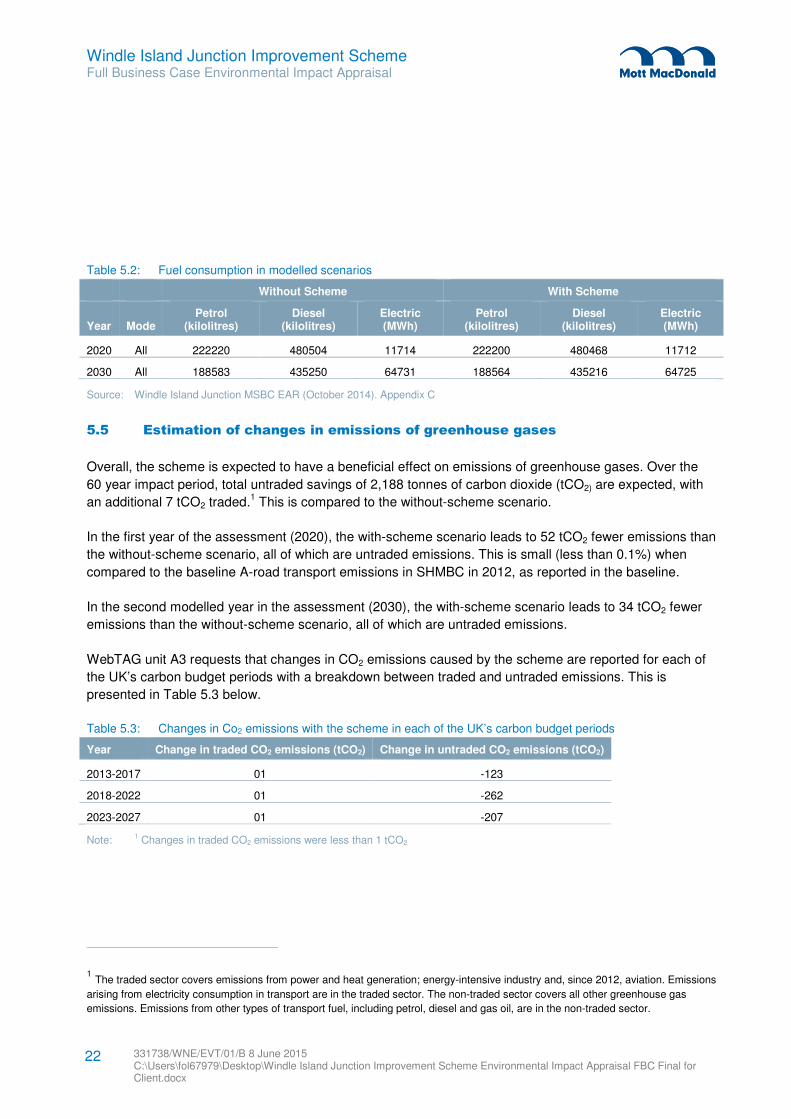
The scheme is expected to reduce the overall energy consumption (in the form of fuel and electricity) of
vehicles using the junction. Table 5.2 summarises the TUBA outputs which show annual energy
consumption in each modelled scenario.
In 2020, the scheme is expected to reduce petrol and diesel consumption by a total of 56 kilolitres. The
scheme is also expected to reduce electricity consumption by 2MWh.
In 2030, the scheme is expected to reduce petrol and diesel consumption by a total of 53 kilolitres. The
scheme is also expected to reduce electricity consumption by 6MWh.
Windle Island Junction Improvement Scheme Full Business Case Environmental Impact Appraisal
331738/WNE/EVT/01/B 8 June 2015 C:\Users\fol67979\Desktop\Windle Island Junction Improvement Scheme Environmental Impact Appraisal FBC Final for Client.docx
22
Table 5.2: Fuel consumption in modelled scenarios
Without Scheme With Scheme
Year Mode Petrol
(kilolitres) Diesel
(kilolitres) Electric (MWh)
Petrol (kilolitres)
Diesel (kilolitres)
Electric (MWh)
2020 All 222220 480504 11714 222200 480468 11712
2030 All 188583 435250 64731 188564 435216 64725
Source: Windle Island Junction MSBC EAR (October 2014). Appendix C
5.5 Estimation of changes in emissions of greenhouse gases
Overall, the scheme is expected to have a beneficial effect on emissions of greenhouse gases. Over the
60 year impact period, total untraded savings of 2,188 tonnes of carbon dioxide (tCO2) are expected, with
an additional 7 tCO2 traded.1 This is compared to the without-scheme scenario.
In the first year of the assessment (2020), the with-scheme scenario leads to 52 tCO2 fewer emissions than
the without-scheme scenario, all of which are untraded emissions. This is small (less than 0.1%) when
compared to the baseline A-road transport emissions in SHMBC in 2012, as reported in the baseline.
In the second modelled year in the assessment (2030), the with-scheme scenario leads to 34 tCO2 fewer
emissions than the without-scheme scenario, all of which are untraded emissions.
WebTAG unit A3 requests that changes in CO2 emissions caused by the scheme are reported for each of
the UK’s carbon budget periods with a breakdown between traded and untraded emissions. This is
presented in Table 5.3 below.
Table 5.3: Changes in Co2 emissions with the scheme in each of the UK’s carbon budget periods
Year Change in traded CO2 emissions (tCO2) Change in untraded CO2 emissions (tCO2)
2013-2017 01 -123
2018-2022 01 -262
2023-2027 01 -207
Note: 1 Changes in traded CO2 emissions were less than 1 tCO2
1 The traded sector covers emissions from power and heat generation; energy-intensive industry and, since 2012, aviation. Emissions
arising from electricity consumption in transport are in the traded sector. The non-traded sector covers all other greenhouse gas
emissions. Emissions from other types of transport fuel, including petrol, diesel and gas oil, are in the non-traded sector.

Windle Island Junction Improvement Scheme Full Business Case Environmental Impact Appraisal
331738/WNE/EVT/01/B 8 June 2015 C:\Users\fol67979\Desktop\Windle Island Junction Improvement Scheme Environmental Impact Appraisal FBC Final for Client.docx
23
5.6 Suggested mitigation measures and recommendations
This high-level assessment has concluded that the Scheme will have a beneficial effect on greenhouse
gas emissions, although the effect is negligible when compared to emissions in the local authority baseline.
Therefore, no mitigation measures are proposed.
Windle Island Junction Improvement Scheme Full Business Case Environmental Impact Appraisal
331738/WNE/EVT/01/B 8 June 2015 C:\Users\fol67979\Desktop\Windle Island Junction Improvement Scheme Environmental Impact Appraisal FBC Final for Client.docx
24
6.1 Introduction
This chapter provides a qualitative, desk-based review of the preferred option for the Scheme, with respect
to the WebTAG appraisal method for landscape. The most recent version of the appraisal methodology
(TAG Unit A3) was issued in November 2014. Townscape has been scoped out of this appraisal, as a
landscape appraisal is more appropriate.
6.2 Methodology
The methodology for appraising the impact of the Scheme on landscape follows the five step general
approach to appraising ‘environmental capital’ described in Chapter 5 of the TAG Unit A3 guidance for
Environmental Impact Appraisal.
This appraisal also follows the additional, landscape specific guidance laid out in Chapter 6 of the TAG
Unit A3 guidance for Environmental Impact Appraisal.
A site visit with a photographic survey of the key local receptors was undertaken of the area on Friday 24th
April 2015.
6.3 Scoping and identification of study area
The proposed works include the following elements:
� Localised widening of intersection within existing highway boundary; and
� Creation of new, and widening to, existing pedestrian refuge islands.
The potential landscape impacts of the scheme will be:
� Permanent loss of vegetation leading to a permanent change in landscape character, tranquillity and/or
visibility of the road infrastructure;
� Temporary loss of vegetation leading to a temporary change in landscape character, tranquillity and/or
visibility of the road infrastructure; and
� The junction becoming a more prominent visual feature in the landscape leading to a permanent
change in landscape character, tranquillity and/or visibility of the road infrastructure.
It is assumed that the potential impacts above may be significant within a radius of 2km from the centre of
the proposed site.
6.4 Identifying key environmental resources and their features
6.4.1 Character areas
The site falls within the Natural England National Character Area 56 “Lancashire Coal Measures”. The key
characteristics of this character area are:
� Fragmented landscape formed by mining, industrial activity and housing;
6 Landscape
Windle Island Junction Improvement Scheme Full Business Case Environmental Impact Appraisal
331738/WNE/EVT/01/B 8 June 2015 C:\Users\fol67979\Desktop\Windle Island Junction Improvement Scheme Environmental Impact Appraisal FBC Final for Client.docx
25
� Densely populated area with a dispersed settlement pattern;
� Gentle hills and valleys;
� Limited woodland cover overall but some woodlands have been established on many post-industrial
sites;
� Agricultural land within the urban fabric mainly permanent grassland or cereal production;
� Field patterns are primarily medium to large and rectangular boundaries are typically divided by post
and wire fences or hedgerows;
� Strong cultural and industrial heritage, associated with heavy industry and mineral extraction; and
� Area is significantly influenced by transport and utilities infrastructure, with rail lines and motorways,
major roads.
6.4.2 Landscape character
The site falls within the intersection of three of the St Helens Council’s Local Landscape Character Types.
The key characteristics of these character areas are as follows:
Broad Rural Slopes Landscape Character Type
� Gently sloping topography with some large ridgelines undulating;
� Undulating landscape offer a range of views;
� Mainly arable farmland with small blocks of broadleaf woodland; and
� Medium to large fields divided by hedgerows in an irregular field pattern.
Residential Valley Infill Landscape Character Type
� Mainly residential area, comprising if the suburbs of St Helens; and
� A mix of housing styles and character from a range of periods.
Undulating Farmland with Woodland Landscape Character Type
� Undulating pastoral and arable farmland;
� Open character with medium to large fields allowing some open views;
� Hedgerows as field boundaries creating strong patterns within the landscape; and
� Tree cover consists of woodland blocks and shelterbelts.
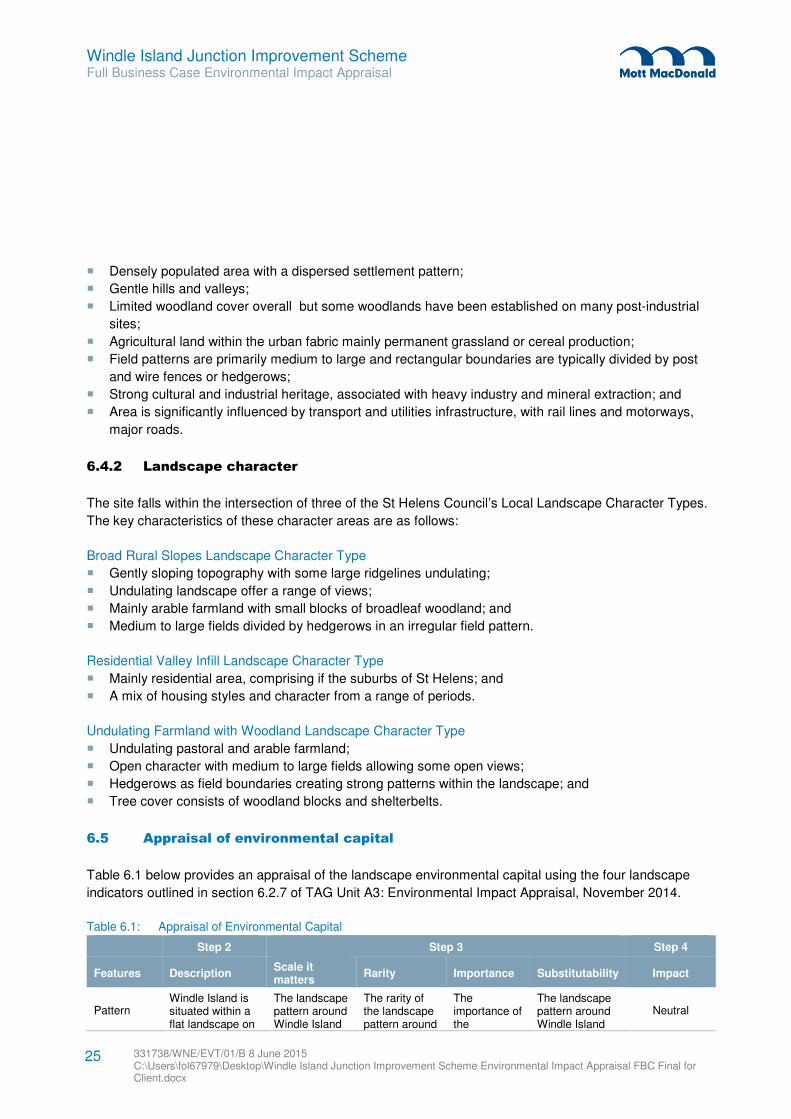
6.5 Appraisal of environmental capital
Table 6.1 below provides an appraisal of the landscape environmental capital using the four landscape
indicators outlined in section 6.2.7 of TAG Unit A3: Environmental Impact Appraisal, November 2014.
Table 6.1: Appraisal of Environmental Capital
Step 2 Step 3 Step 4
Features Description Scale it matters
Rarity Importance Substitutability Impact
Pattern Windle Island is situated within a flat landscape on
The landscape pattern around Windle Island
The rarity of the landscape pattern around
The importance of the
The landscape pattern around Windle Island
Neutral
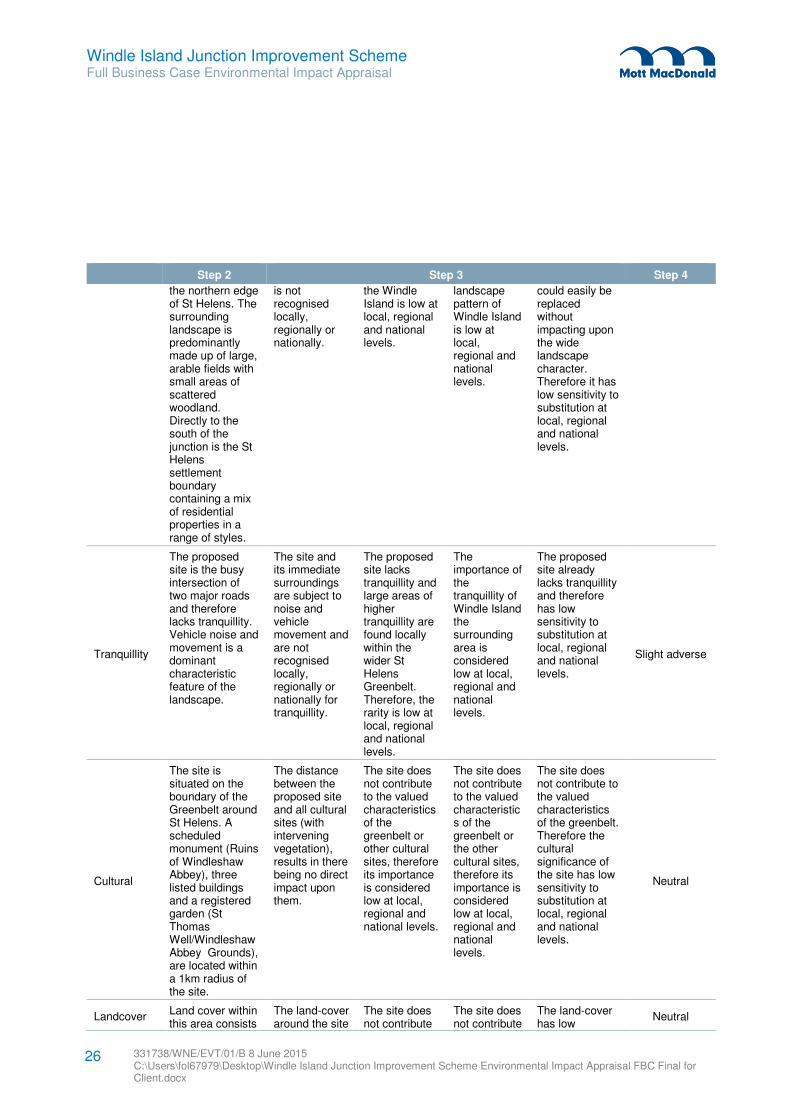
Windle Island Junction Improvement Scheme Full Business Case Environmental Impact Appraisal
331738/WNE/EVT/01/B 8 June 2015 C:\Users\fol67979\Desktop\Windle Island Junction Improvement Scheme Environmental Impact Appraisal FBC Final for Client.docx
26
Step 2 Step 3 Step 4
the northern edge of St Helens. The surrounding landscape is predominantly made up of large, arable fields with small areas of scattered woodland. Directly to the south of the junction is the St Helens settlement boundary containing a mix of residential properties in a range of styles.
is not recognised locally, regionally or nationally.
the Windle Island is low at local, regional and national levels.
landscape pattern of Windle Island is low at local, regional and national levels.
could easily be replaced without impacting upon the wide landscape character. Therefore it has low sensitivity to substitution at local, regional and national levels.
Tranquillity
The proposed site is the busy intersection of two major roads and therefore lacks tranquillity. Vehicle noise and movement is a dominant characteristic feature of the landscape.
The site and its immediate surroundings are subject to noise and vehicle movement and are not recognised locally, regionally or nationally for tranquillity.
The proposed site lacks tranquillity and large areas of higher tranquillity are found locally within the wider St Helens Greenbelt. Therefore, the rarity is low at local, regional and national levels.
The importance of the tranquillity of Windle Island the surrounding area is considered low at local, regional and national levels.
The proposed site already lacks tranquillity and therefore has low sensitivity to substitution at local, regional and national levels.
Slight adverse
Cultural
The site is situated on the boundary of the Greenbelt around St Helens. A scheduled monument (Ruins of Windleshaw Abbey), three listed buildings and a registered garden (St Thomas Well/Windleshaw Abbey Grounds), are located within a 1km radius of the site.
The distance between the proposed site and all cultural sites (with intervening vegetation), results in there being no direct impact upon them.
The site does not contribute to the valued characteristics of the greenbelt or other cultural sites, therefore its importance is considered low at local, regional and national levels.
The site does not contribute to the valued characteristics of the greenbelt or the other cultural sites, therefore its importance is considered low at local, regional and national levels.
The site does not contribute to the valued characteristics of the greenbelt. Therefore the cultural significance of the site has low sensitivity to substitution at local, regional and national levels.
Neutral
Landcover Land cover within this area consists
The land-cover around the site
The site does not contribute
The site does not contribute
The land-cover has low
Neutral

Windle Island Junction Improvement Scheme Full Business Case Environmental Impact Appraisal
331738/WNE/EVT/01/B 8 June 2015 C:\Users\fol67979\Desktop\Windle Island Junction Improvement Scheme Environmental Impact Appraisal FBC Final for Client.docx
27
Step 2 Step 3 Step 4
of large, intensively-farmed, arable fields. These fields are divided by hedgerow or post and wire fence. Tree and woodland planting is limited. Residential properties are along Rainford Road to the north and south of the A580.
is on the boundary of the St Helens greenbelt that provides an important visual and physical divide between surrounding communities. The land-cover around the site is not recognised regionally or nationally.
to the valued characteristics of the greenbelt and the limited tree planting alongside the highway is not rare within the local area. Therefore the land-cover is considered low at local, regional and national levels.
to the valued characteristics of the greenbelt, therefore its importance is considered low at local, regional and national levels.
sensitivity to substitution at local, regional and national levels.
6.6 Appraisal of the proposal’s impact
Table 6.2: Appraisal of the proposal’s impact
Sensitivity to change Potential impacts Magnitude of effects
Pattern
The landscape pattern of Windle Island and its immediate surroundings is not rare or important at any level and has low sensitivity substitution. Therefore, the landscape pattern here has low sensitivity to change.
Extension of the carriageway resulting in the loss of grass verges;
Extension of the road carriageway and the increased signage at the intersection could result in the road becoming a more apparent feature to the surrounding residential properties; and
Main effect will be during the construction phase and will impact upon residential properties on Rainford Road; these impacts will be temporary.
The low sensitivity of the landscape pattern in this area coupled with the low significance of the potential impacts, results in a neutral effect on the landscape pattern.
Tranquillity
The tranquillity of Windle Island and its immediate surroundings is not rare or important at any level and has low sensitivity to substitution. Therefore, the tranquillity here has low sensitivity to change
The increased quantity of road infrastructure may cause additional noise and vehicle movements. This impact is anticipated to be limited in scale and will have low significance.
Construction activities for the residential properties on Rainford Road will have an adverse impact on tranquillity, due to the close proximity between residential properties and the area of proposed works; these impacts will be temporary.
The low sensitivity of the tranquillity in this area coupled with the slightly adverse of the potential impacts, results in a slight adverse effect on tranquillity.
Cultural
The site does not contribute to the valued characteristics of the greenbelt and the cultural value of the proposed site and its immediate surroundings is not rare. Overall, the immediate area has low sensitivity to substitution resulting in low sensitivity to
The proposed works will have no effect on the cultural sites stated due to distance or intervening vegetation or buildings. The proposed changes are limited in scale (loss of grassed verges).
No impacts are envisaged; resulting in a neutral effect on the magnitude of effects of the site.

Windle Island Junction Improvement Scheme Full Business Case Environmental Impact Appraisal
331738/WNE/EVT/01/B 8 June 2015 C:\Users\fol67979\Desktop\Windle Island Junction Improvement Scheme Environmental Impact Appraisal FBC Final for Client.docx
28
Sensitivity to change Potential impacts Magnitude of effects
change
Land-cover
The land-cover value of Windle Island and its immediate greenbelt surroundings is not rare and there will be no loss of important green space. It has low sensitivity to substitution. Therefore, the landscape pattern here has low sensitivity to change
Extension of the carriageway resulting in the loss of grass verges is the only potential impact relating to land cover.
Limited impacts are envisaged; resulting in a neutral effect on the land cover on the magnitude of effects of the site.
6.7 Overall assessment score
The following provides an overview of the overall impact of the Scheme on landscape:
� It is predicted that there will be a neutral effect on the landscape pattern;
� It is predicted that there will be a slight adverse effect on the landscape tranquillity;
� It is predicted that there will be a neutral effect on the landscape culture;
� It is predicted that there will be a neutral effect on the land-form; and
� Overall it is predicted that there will be a neutral effect on the landscape.
6.8 Suggested mitigation measures and recommendations
With only amenity grassland being removed, it is not anticipated any mitigation planting will be required.
The realigned grass verges from the proposed road layout should be reinstated with local grass seed and
left in a tidy appearance. It is not proposed to remove the hedge along the south east corner of the junction
but it should be protected as per BS 5837:2012 (Trees in relation to design, demolition and construction)
as it acts as a threshold between the road and the residential properties. The placement of additional road
signage should be sympathetic to the close proximity of the residential properties where possible.
Construction should be carried out using industry best practice to reduce any potentially adverse effects.
Lighting associated with the construction phase of the proposed development should be designed to
minimise light pollution at night, whilst being consistent with the requirements of site safety and security.

Windle Island Junction Improvement Scheme Full Business Case Environmental Impact Appraisal
331738/WNE/EVT/01/B 8 June 2015 C:\Users\fol67979\Desktop\Windle Island Junction Improvement Scheme Environmental Impact Appraisal FBC Final for Client.docx
29
7.1 Introduction
This chapter provides a qualitative, desk-based review of the preferred option for the Scheme, with respect
to the WebTAG appraisal method for historic environment. The most recent version of the appraisal
methodology (TAG Unit A3) was issued in November 2014.
The historic environment is defined as: ‘all aspects of the environment resulting from the interaction
between people and places through time, including all surviving physical remains of past human activity,
whether visible, buried or submerged, and landscaped and planted or managed flora’ (NPPF 2012, Annex
2 Glossary).
Heritage assets are: 'A building, monument, site, place, area or landscape identified as having a degree of
significance meriting consideration in planning decisions. Heritage assets include designated heritage
assets and assets identified by the local planning authority (including local listing)’ (NPPF 2012, Annex 2
Glossary). Designated heritage assets are world heritage sites, scheduled monuments, listed buildings,
conservation areas, registered parks and gardens, registered battlefields and protected wreck sites. Non-
designated heritage assets can be identified by the Local Authority (local listings, entries on the historic
environment record (HER)) or through the EIA process, via research or surveys.
7.2 Methodology
The methodology for appraising the impact of the scheme on the historic environment follows a five step
approach to appraising environmental capital (WebTAG 2014).
Assessment of the significance of features involved appraisal against a set of judgemental indicators (the
scale the asset matters (or its contribution), the significance of the asset, and the rarity of the resource) to
establish the significance of each key historic environmental resource in question.
The overall effect of the scheme on the historic environment resource was then considered within
qualitative guidance as outlined in the seven-point scale for determining scheme effect (WebTAG guidance
for the Historic Environment).
7.3 Scoping and identification of study area
The assessment considers heritage assets; both designated and non-designated. A study area of a 500m
buffer from the proposed development was chosen to compile a comprehensive baseline under which to
assess the impact of the development upon heritage assets. The study area is considered sufficient in
order to assess impacts from the scheme to both built heritage and buried archaeological remains.
Heritage assets include scheduled monuments, listed buildings, conservation areas, non-designated
below-ground archaeological remains, locally listed and other historically important buildings and historic
landscapes.
7 Historic Environment
Windle Island Junction Improvement Scheme Full Business Case Environmental Impact Appraisal
331738/WNE/EVT/01/B 8 June 2015 C:\Users\fol67979\Desktop\Windle Island Junction Improvement Scheme Environmental Impact Appraisal FBC Final for Client.docx
30
The baseline was compiled from the following freely available resources as listed below:
� Historic England National Heritage List for England;
� Old maps.com;
� Heritage Gateway;
� Archaeological Data Service; and
� Historic England Pastscape.
7.4 Identifying key environmental resources and their features
The range of heritage assets identified as part of the baseline, and within 500m from the scheme, is
summarised in Table 7.1 below.
Table 7.1: Key Environmental Resources
Resource Description Legislation and Policy Condition
Listed buildings 4 grade II listed structures:
• The Malthouse
• Numbers 53 and 55 Rainford Road
• Number 59 Rainford Road
• Cockleshell Cottage
Planning (Listed Buildings and Conservation Area) Act 1990
National Planning Policy Framework
Local planning policy (St Helens Local Plan, Core Strategy, Policy CQL 4)
All extant built structures in good condition which contribute to the wider setting of Windle village.
Grade II registered park and garden
St Helens Borough cemetery
National Planning Policy Framework
Local planning policy (St Helens Local Plan, Core Strategy, Policy CQL 4)
A public cemetery opened in 1858; extended to the north and west in the late-1930s (outside the area registered). It is in a good state of preservation.
Undesignated and unknown archaeological remains
The site lies within an area which has historic coal mining, associated with the Windle Colliery. Windle Farm and two smithies were also located within the crossroad nearby to the proposals. It is uncertain as to how much of these remains were removed by the construction of the East Lancashire Road in the 1930’s or by further highway works within the development footprint.
National Planning Policy Framework
Local planning policy
(St Helens Local Plan, Core Strategy, Policy CQL 4)
Unknown
Windle Island Junction Improvement Scheme Full Business Case Environmental Impact Appraisal
331738/WNE/EVT/01/B 8 June 2015 C:\Users\fol67979\Desktop\Windle Island Junction Improvement Scheme Environmental Impact Appraisal FBC Final for Client.docx
31
7.5 Appraisal of Environmental Capital
A more detailed desk based assessment has been undertaken using a WegTAG worksheet, which sets out
the appraisal of environmental capital for the heritage resource identified within 250m of the scheme. The
work below has been based on this detailed assessment, which can be provided for further information if
required. The following is a summary of this rationale.
7.5.1 Designated heritage assets
7.5.1.1 Listed buildings
A total of four Grade II listed structures are located within 500m of the site (as listed above). None of the
structures are located within the immediate vicinity to the proposed development. There is no inter-visibility
between the proposals and the listed structures and there will be no impact upon the setting of the listed
buildings.
7.5.1.2 Registered Park and Garden
The Grade II registered park and garden of the Borough Cemetery, lies within 500m of the site. The
modern extension to the cemetery extends to within 150m to the southeast of the Scheme. Whilst the
proposals will be visible from the cemetery, the proposals do not represent any material change to the
baseline conditions, and therefore the setting of the cemetery is maintained. There will be no impact on the
cemetery.
7.5.2 Undesignated archaeological remains
Windle is derived from the old English Wyndell, meaning windy hill, reflecting the fact that the eastern
extent of the town was exposed to the wind (Cameron, K. 19962).
Windle Chantry, known as Windleshaw Abbey (Historic England Pastscape number 69774) was probably
built by Thomas Gerard around 1435. The structure lay within the original footprint of the medieval Chapel
of St Thomas of Canterbury which pre-dated Windleshaw Abbey. The remains of this chapel are thought to
have been located in the Abbey complex and may have originally extended further to the east.
The centre of the Windleshaw Abbey Chantry lies some 600m to the south east of the development site,
although the grounds did extend further and closer to the development area. Following the dissolution of
the monasteries and in later accordance with the Abolition of Chantries Acts (1545 and 1547) the building
decayed and the ground around the ruined chapel was used as a burial place instead.
St Thomas Well (Historic England Pastcape number 69773) is located 470m south east of the
development area. This well also dates from the medieval period and survives due to the water from the
2 Cameron, K. 1996. English Place Names. Batsford.
Windle Island Junction Improvement Scheme Full Business Case Environmental Impact Appraisal
331738/WNE/EVT/01/B 8 June 2015 C:\Users\fol67979\Desktop\Windle Island Junction Improvement Scheme Environmental Impact Appraisal FBC Final for Client.docx
32
well having been reputed to have healing properties; originally a public footpath led into the chapel and to
the well, but this was removed during the 20th century when the new Borough cemetery was opened.
The 1849 Ordnance Survey map shows that within the middle of the 19th century the development area lay
within land associated with the Windle Colliery; in a parcel of land labelled as Windle ashes. This land is
likely to have been used as a colliery tip site, but it is possible that remains of earlier occupation, potentially
related to the medieval activities at Windleshaw Abbey, may remain within this area.
The Windle Island junction is shown in the 1849 OS map as a simple crossroads, with Rainford Road and
Bleak Hill Road as the primary highway. The Windle colliery itself is shown situated off Bleak Hill Road and
an area to the south east is shown as part of the Windleshaw Abbey grounds ruins.
In 1927 houses were constructed on the western extent of Rainford Road, and by 1934 the East
Lancashire Road had been constructed within the development area (it was officially opened by King
George V on 18 July). The East Lancashire Road was aligned east west across the Windle Ashes land
parcel, and a large roundabout connected it to Rainford Road and Bleak Hill Road, forming a six-pronged
exit roundabout. To the north, a section of road aligned east-west allowed access from Rainford Road to
Crank Road. Infilling also is predominant from the 1930s, with houses being located along the main arterial
routes of Rainford Road and Moss Lane and into Windle Village.
By 1952, Rainford Road is enlarged by land take from the immediate east and west of the original road
alignment. The construction of the B5201 removed the straight linear route from Rainford Road to Crank
Road and realigned the route slightly to the south.
The development area therefore sits within land parcels which prior to the 1900’s had been largely used for
rural and agricultural purposes, with an ecclesiastical centre located to the south of the development area.
During the 19th century, some localised coal extraction occurred nearby to the development site. By the
twentieth century, further industry, infilling and the establishment of the East Lancashire Road is likely to
have removed buried remains within the immediate vicinity to the proposed development area. It is
possible that remains associated with medieval and post medieval activity may still remain within the
development footprint.
7.6 Appraisal of the proposal’s impact
The Scheme will not impact on any built heritage asset. No listed structures lie within the immediate vicinity
to the proposal and there is no inter-visibility between the proposal and the listed structures which may
alter or affect the setting of the structure. Likewise, there will be no impact to the registered park and
garden of the Borough Cemetery.
The proposed highway improvements have the potential to impact on unknown buried archaeological
remains within the footprint of the proposed development area. It is possible that medieval remains
associated with the Windleshaw Abbey may extend north and into the development area. Impacts to
buried archaeological remains are likely to occur during re-grading or excavation of ground to provide new
highway or to extend the existing highway. The removal of any archaeological remains through the
Windle Island Junction Improvement Scheme Full Business Case Environmental Impact Appraisal
331738/WNE/EVT/01/B 8 June 2015 C:\Users\fol67979\Desktop\Windle Island Junction Improvement Scheme Environmental Impact Appraisal FBC Final for Client.docx
33
construction of the scheme would give rise to a slight adverse impact on remains of low value, leading to
a slight adverse effect.
7.7 Overall assessment score
The overall assessment score for the scheme is considered to be slight adverse. This assessment takes
into account cumulative impacts of removal of heritage assets. This also considers in-combination effects
upon the historic environment resource.
7.8 Suggested mitigation measures and recommendation
Where archaeological remains may be lost as a result of the scheme, an appropriate programme of
archaeological investigation should be implemented prior to, or during construction. The level of
investigation will be proportionate to the significance of the remains likely to be affected and the level of
impact.
Windle Island Junction Improvement Scheme Full Business Case Environmental Impact Appraisal
331738/WNE/EVT/01/B 8 June 2015 C:\Users\fol67979\Desktop\Windle Island Junction Improvement Scheme Environmental Impact Appraisal FBC Final for Client.docx
34
8.1 Introduction
This chapter provides a qualitative, desk-based review of the preferred option for the Scheme, with respect
to the WebTAG appraisal method for historic environment. The most recent version of the appraisal
methodology (TAG Unit A3) was issued in November 2014.
8.2 Methodology
A field survey was undertaken to areas that are directly affected by the works and the immediate
surrounding area. The purpose of the visit was to identify any ecologically important habitats and potential
to support protected species . This was based on the Joint Nature Conservation Committee’s (JNCC)
Phase 1 Habitat Survey methodology (JNCC 2010).
A desk study has been undertaken to identify any protected sites within 2km of the works, using Multi
Agency Geographic Information for the Countryside website, http://www.magic.gov.uk/.
The methodology for the assessment adheres to the WebTAG guidance (November 2014), following the
five step general approach to appraising ‘environmental capital’ described in Chapter 5 of the TAG Unit A3
Guidance for Environmental Impact Appraisal, and Impacts on Biodiversity in Chapter 9. It includes the
assessment of each feature’s biodiversity value, the magnitude of the potential impact that each feature
may experience, and, using these two parameters identifying the overall effect.
As indicated in the WebTAG Unit A3 guidance document, only those key environmental resources where
the project has the potential for significant effect are included for assessment.
8.3 Scoping and identification of study area
The proposed works include the elements outlined in Section 2.2. As a result of the proposed activities
(see Chapter 2), the scheme has the potential to have the following impacts on biodiversity:
� Temporary noise, vibration and dust deposition on adjacent habitats during construction, potentially
affecting breeding birds within a hedgerow; and
� Loss of amenity grassland habitat.
8.4 Identifying key environmental resources and their features
A survey was undertaken in April 2015, during which any notable habitats present and any potential
presence of protected species was noted. A desk study was undertaken using the website
http://www.magic.gov.uk/ to identify any protected site or species records within 2km of the Scheme.
There are no statutory designated sites within 2km of the works. While the works are within a Site of
Special Scientific Interest (SSSI) buffer zone, due to the very localised scope of works Natural England will
not need to be contacted.
8 Biodiversity
Windle Island Junction Improvement Scheme Full Business Case Environmental Impact Appraisal
331738/WNE/EVT/01/B 8 June 2015 C:\Users\fol67979\Desktop\Windle Island Junction Improvement Scheme Environmental Impact Appraisal FBC Final for Client.docx
35
Habitats recorded during the site survey were of low ecological value. They included hardstanding and
amenity grassland. There is an ornamental hedgerow adjacent to the works, which has potential for use by
common breeding birds, but this will not be directly affected.
Farmland birds were identified on magic.gov.uk as having been recorded within the vicinity of the works,
including lapwing and corn bunting. Various farmland birds are listed on the UK Post 2010 biodiversity
framework and remain on local Biodiversity Action Plans (BAPS). However, these records were found
during the desk study; no evidence of farmland birds, or habitat likely to be used by farmland birds, was
found in the vicinity of the works during the walkover. Therefore, no farmland birds would be directly or
indirectly impacted by the works. Farmland birds are unlikely to be significantly affected by the proposed
scheme, and are therefore not assessed as a key environmental receptor.
8.5 Appraisal of environmental capital
8.5.1 Breeding birds
The ornamental hedgerow adjacent to the works has potential for breeding birds which could be affected
by construction. The hedgerow is very unlikely to support Schedule 1 birds, therefore any that would be
nesting would likely be of common, abundant species. Their overall biodiversity value is therefore
considered to be low.
8.5.2 Habitats
The amenity grassland habitat to be removed is considered as low biodiversity value due to the low
number of common species present.
8.6 Appraisal of the proposal’s impact
There would be a slight adverse impact on breeding birds due to indirect impacts of noise, vibration,
disturbance and dust deposition. However, if the vegetation clearance were to be undertaken outside the
bird nesting season of March to August or if the works are to occur more than 5 metres from the hedgerow,
then the impact would be neutral.
There is a negligible impact on habitats due to the direct loss of amenity grassland which has low
biodiversity value.
8.7 Overall assessment score
It is therefore predicted that there would be a neutral effect on breeding birds, assuming that the habitat
clearance works were undertaken outside of the nesting season that runs from March to August or are
more than 5 metres away. The impact on habitats is also anticipated to be neutral. Therefore, the overall
impact of the scheme on biodiversity is neutral.
Windle Island Junction Improvement Scheme Full Business Case Environmental Impact Appraisal
331738/WNE/EVT/01/B 8 June 2015 C:\Users\fol67979\Desktop\Windle Island Junction Improvement Scheme Environmental Impact Appraisal FBC Final for Client.docx
36
8.8 Suggested mitigation measures and recommendations
Where works are to occur within 5 metres of the ornamental hedgerow, these would ideally be undertaken
outside of the bird breeding season (March to August). If they are to occur within the nesting season a
suitably qualified ecologist would need to undertake a breeding bird check no more than 24 hours prior to
the works. Any active nests found would have a demarcation line put in place around the nest where no
works would be able to take place, until the chicks have fledged. The demarcation line would include
sufficient area that disturbance did not impede the likelihood of breeding success.

Windle Island Junction Improvement Scheme Full Business Case Environmental Impact Appraisal
331738/WNE/EVT/01/B 8 June 2015 C:\Users\fol67979\Desktop\Windle Island Junction Improvement Scheme Environmental Impact Appraisal FBC Final for Client.docx
37
9.1 Overview
The environmental appraisal has been undertaken by giving consideration to the benefits and impacts
of the proposed design, construction and operation of the Scheme, for the eight environmental
themes in TAG Unit A3. In addition, the effects of the scheme have been identified using a seven-
point scale system, in accordance with the Web-TAG criteria as shown in Table 9.1 below.
Table 9.1: Seven-point scale system for determining scheme effect
Impact
--- Large Adverse
-- Moderate Adverse
- Slight Adverse
0 Neutral
+ Slight Beneficial
++ Moderate Beneficial
+++ Large Beneficial
9.2 Appraisal Summary Table
Following the appraisal of the environmental impacts associated with the Scheme, Table 9.2 provides an
AST to inform the Full Business Case.
To link with other documentation prepared for the Windle Island MSBC, the quantitative figures calculated
as part of the EAR (October 2014) (331738/ITN/ITD/001/A) have been included in the ‘Monetary’ column
below. The appraisal that has been undertaken in this report is qualitative; therefore, quantitative values for
noise, air quality and greenhouse gases have not been calculated as part of the appraisal process.
Table 9.2: AST
Environmental Impact
Summary of impacts Quantitative Qualitative Monetary £
(NPV)*
Distributional/
7-pt scale
Noise
Impacts identified include noise increases associated with an increase in traffic flow and speed. This could be offset with mitigation in the form of acoustic barriers. Assuming appropriate noise mitigation measures are put into place, it is not anticipated that there will be any significant impacts of the scheme on noise. Therefore, the overall impact is neutral.
Neutral N/A 0
9 Appraisal Summary Table
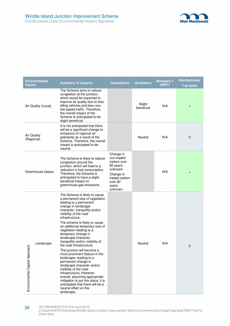
Windle Island Junction Improvement Scheme Full Business Case Environmental Impact Appraisal
331738/WNE/EVT/01/B 8 June 2015 C:\Users\fol67979\Desktop\Windle Island Junction Improvement Scheme Environmental Impact Appraisal FBC Final for Client.docx
38
Environmental Impact
Summary of impacts Quantitative Qualitative Monetary £
(NPV)*
Distributional/
7-pt scale
Air Quality (Local)
The Scheme aims to reduce congestion at the junction, which would be expected to improve air quality due to less idling vehicles and less very low speed traffic. Therefore, the overall impact of the Scheme is anticipated to be slight beneficial.
Slight beneficial
N/A +
Air Quality (Regional)
It is not anticipated that there will be a significant change to emissions of regional air pollutants as a result of the Scheme. Therefore, the overall impact is anticipated to be neutral.
Neutral N/A 0
Greenhouse Gases
The Scheme is likely to reduce congestion around the junction, which will lead to a reduction in fuel consumption. Therefore, the Scheme is anticipated to have a slight beneficial impact on greenhouse gas emissions.
Change in non-traded carbon over 60 years: unknown
Change in traded carbon over 60 years: unknown
N/A +
En
viron
men
tal C
ap
ita
l A
ppro
ach Landscape
The Scheme is likely to cause a permanent loss of vegetation leading to a permanent change in landscape character, tranquillity and/or visibility of the road infrastructure.
The scheme is likely to cause an additional temporary loss of vegetation leading to a temporary change in landscape character, tranquillity and/or visibility of the road infrastructure.
The junction will become a more prominent feature in the landscape, leading to a permanent change in landscape character and/or visibility of the road infrastructure. However, overall, assuming appropriate mitigation is put into place, it is anticipated that there will be a neutral effect on the landscape.
Neutral N/A
0
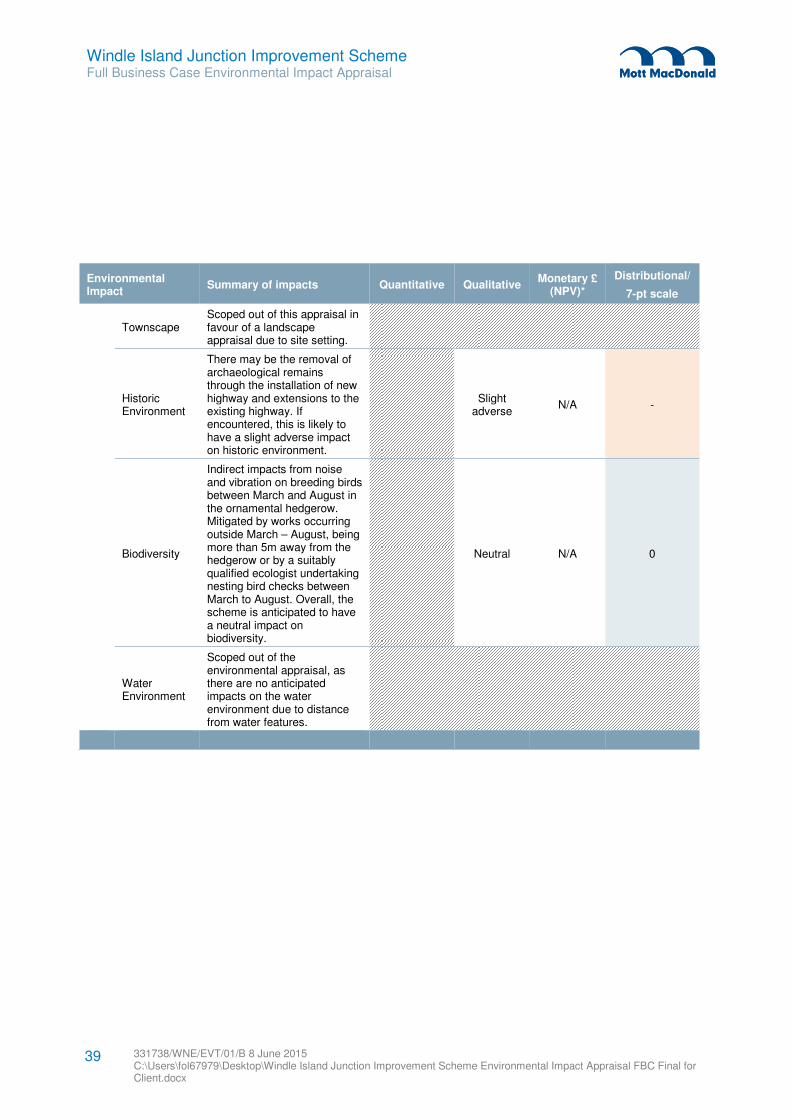
Windle Island Junction Improvement Scheme Full Business Case Environmental Impact Appraisal
331738/WNE/EVT/01/B 8 June 2015 C:\Users\fol67979\Desktop\Windle Island Junction Improvement Scheme Environmental Impact Appraisal FBC Final for Client.docx
39
Environmental Impact
Summary of impacts Quantitative Qualitative Monetary £
(NPV)*
Distributional/
7-pt scale
Townscape Scoped out of this appraisal in favour of a landscape appraisal due to site setting.
Historic Environment
There may be the removal of archaeological remains through the installation of new highway and extensions to the existing highway. If encountered, this is likely to have a slight adverse impact on historic environment.
Slight adverse
N/A -
Biodiversity
Indirect impacts from noise and vibration on breeding birds between March and August in the ornamental hedgerow. Mitigated by works occurring outside March – August, being more than 5m away from the hedgerow or by a suitably qualified ecologist undertaking nesting bird checks between March to August. Overall, the scheme is anticipated to have a neutral impact on biodiversity.
Neutral N/A 0
Water Environment
Scoped out of the environmental appraisal, as there are no anticipated impacts on the water environment due to distance from water features.
Windle Island Junction Improvement Scheme Full Business Case Environmental Impact Appraisal
331738/WNE/EVT/01/B 8 June 2015 C:\Users\fol67979\Desktop\Windle Island Junction Improvement Scheme Environmental Impact Appraisal FBC Final for Client.docx
40
10.1 Summary of appraisal
To inform the Full Business Case, an appraisal of the environmental effects of the works has been
undertaken in line with TAG (TAG Unit A3: Environmental Impact Appraisal, November 2014). The
appraisal considers the impacts (both positive and negative) of the proposed design, construction and
operation of the Scheme, through the use of the eight environmental themes from TAG Unit A3. These
impacts have been appraised by relevant Mott MacDonald technical specialists, and coordinated by an
environmental assessment specialist. This appraisal provides an overview of the proposed scheme, as
well as a summary of the previous environmental work that was undertaken in September 2014.
10.2 Summary of likely environmental effects
This environmental impact appraisal provides an initial overview of the potential environmental effects
(both positive and negative) associated with the Scheme. A summary of the likely overall impacts of the
project is proposed below:
� Noise –a neutral impact on noise is anticipated, assuming appropriate noise mitigation measures are
put into place;
� Air Quality (Local) – the scheme is anticipated to have a slight beneficial impact on local air quality;
� Air Quality (Regional) – there is not expected to be a significant change to emissions of regional air
pollutants as a result of the scheme and therefore, the impact will be neutral;
� Greenhouse Gas – the scheme is anticipated to have a slight beneficial impact due to the reduction of
congestion and fuel consumption;
� Landscape – overall, there is likely to be a neutral impact on the surrounding landscape;
� Townscape – scoped out of this appraisal in favour of undertaking a landscape appraisal;
� Historic Environment – the installation of new infrastructure has the potential to affect buried
archaeological remains, having a slight adverse impact;
� Biodiversity – a neutral effect on the biodiversity is anticipated following the environmental appraisal;
and
� Water Environment – scoped out of this environmental impact appraisal as there are no anticipated
impacts on the water environment.
10.3 Summary of guidance
This environmental impact appraisal has been developed in line with TAG (TAG Unit A3: Environmental
Impact Appraisal, November 2014) and has been undertaken in tandem with the social and distributional
appraisal, to inform the development of this Full Business Case.
10.4 Next steps
This environmental impact appraisal will be included as an appendix to the Full Business Case for the
proposed Scheme. This appraisal will help inform the decision-making for major transport scheme funding.
10 Conclusions
Windle Island Junction Improvement Scheme Full Business Case Environmental Impact Appraisal
331738/WNE/EVT/01/B 8 June 2015 C:\Users\fol67979\Desktop\Windle Island Junction Improvement Scheme Environmental Impact Appraisal FBC Final for Client.docx
41
If the business case is successful in obtaining funding, further environmental work will be required in
accordance with the Town and Country Planning Act 1990 and may be subject to the Town and Country
Planning (EIA) Regulations 2011.