Embed Size (px)
Citation preview

EXHIBIT A
Designation Report on the
E. L. Baxter Davidson Historic Markers and Monuments
Williams Memorial Presbyterian Church Wall and Marker
Charlotte, N.C.
Williams Memorial Presbyterian Church Wall
Williams Memorial Presbyterian Church Marker
1. Name and Location of the Property. The Williams Memorial Presbyterian Church Wall and Marker
are located at 4700 Beatties Ford Road, within Charlotte’s sphere of influence. The tax parcel number
for the property on which the structures are located is 04117101, and the UTM Coordinates are 17S
513132E 3906225N.
2. Name and Address of Parties to be Notified.
a. North Carolina Department of Transportation
Division 10, District 2 Office
7605 District Drive
Charlotte, N.C. 28213
District Engineer: Wendy Taylor; (980) 523-0000; [email protected]
b. Williams Memorial Presbyterian Church
4700 Beatties Ford Road
Charlotte, N.C. 28216
Williams Memorial Presbyterian Church Wall & Marker, Charlotte
Exhibit A – Page 2
(704) 392 8816; [email protected]
3. Ad Valorem Tax Appraisal. As of January 2021, the total appraised value of the property on which
the Williams Memorial Presbyterian Church Wall and Marker stand is $1,259,400. The property is
currently exempt from the payment of property taxes.
The Williams Memorial Presbyterian Church Wall and Marker
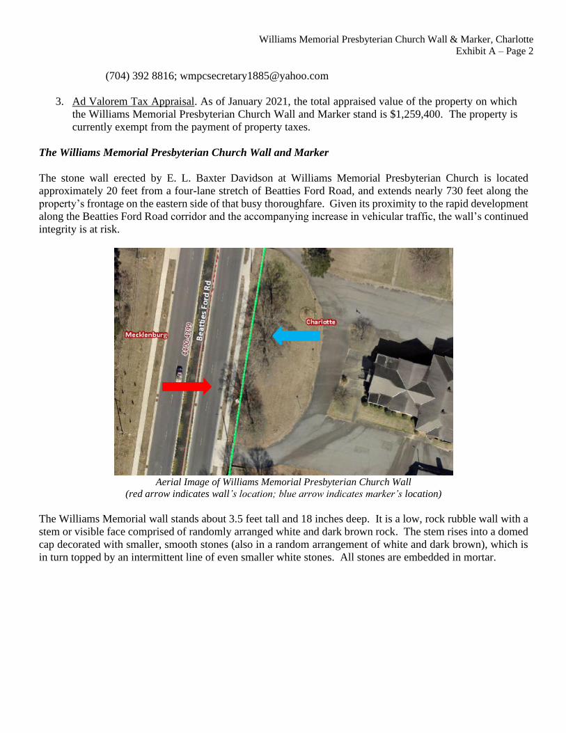
The stone wall erected by E. L. Baxter Davidson at Williams Memorial Presbyterian Church is located
approximately 20 feet from a four-lane stretch of Beatties Ford Road, and extends nearly 730 feet along the
property’s frontage on the eastern side of that busy thoroughfare. Given its proximity to the rapid development
along the Beatties Ford Road corridor and the accompanying increase in vehicular traffic, the wall’s continued
integrity is at risk.
Aerial Image of Williams Memorial Presbyterian Church Wall
(red arrow indicates wall’s location; blue arrow indicates marker’s location)
The Williams Memorial wall stands about 3.5 feet tall and 18 inches deep. It is a low, rock rubble wall with a
stem or visible face comprised of randomly arranged white and dark brown rock. The stem rises into a domed
cap decorated with smaller, smooth stones (also in a random arrangement of white and dark brown), which is
in turn topped by an intermittent line of even smaller white stones. All stones are embedded in mortar.

Williams Memorial Presbyterian Church Wall & Marker, Charlotte
Exhibit A – Page 3
Looking Toward Southern Terminus Detail of Domed Cap
of Williams Memorial Wall of Williams Memorial Wall
Northern Entrance to Williams Memorial Presbyterian Church Property
Looking Toward Northern Terminus of Wall
In form and execution, the Williams Memorial wall is the least refined of the stone structures erected by E. L.
Baxter Davidson in north Mecklenburg County. In comparison, the walls he provided for Huntersville’s
Hopewell Presbyterian Church span both sides of Beatties Ford Road and are longer (approximately 1,000 feet
long on the eastern side of Beatties Ford Road and approximately 830 feet long on the western side), taller
(ranging from 5 to 6 feet tall on the eastern side and from 3 to 4 feet tall on the western side), and deeper (both
Hopewell walls are approximately 2 feet deep). The Hopewell walls are also more elaborate, featuring
alternating symmetrical bands of white and dark brown rocks, as well as stairways and more piers. The
Williams Memorial wall features only two openings providing access for a semicircular driveway into the
church grounds.

Williams Memorial Presbyterian Church Wall & Marker, Charlotte
Exhibit A – Page 4
Southern Entrance to Williams Memorial Presbyterian Church Property
Looking Toward Southern Terminus of Wall
A stone pier provided by Baxter Davidson stands in front of the main church building, nearly 50 feet behind
the stone wall. The pier resembles a similar marker on the grounds of Hopewell Presbyterian Church. Both
markers feature a stem composed of alternating strings of rough-faced dark brown stones and strings of rough-
faced white stones, all embedded in mortar. Each marker rises perpendicularly from a toeless foundation to a
pyramidal cap decorated with small, smooth, lighter-colored stones, and features a metal plaque displaying the
name and founding date of the relevant church. Both markers stand approximately 6 feet tall and 2.5 feet in
both length and width, but the Hopewell marker has a flint-rock finial fixed atop its cap that adds approximately
12 inches to its overall height. The Williams Memorial marker has no finial, but the slightly flattened top of
its cap suggests that a stone finial may have originally topped the pier.

Williams Memorial Presbyterian Church Wall & Marker, Charlotte
Exhibit A – Page 5
Williams Memorial Church Marker

Williams Memorial Presbyterian Church Wall & Marker, Charlotte
Exhibit A – Page 6
Southern Entrance to Williams Memorial Presbyterian Church Property
Looking Toward Northern Terminus of Wall

Williams Memorial Presbyterian Church Wall & Marker, Charlotte
Exhibit A – Page 7
Red line (indicated by red arrow) shows location of wall;
black diamond (indicated by black arrow) shows approximate location of marker


![Cenntenniel Memorial English Presbyterian Congregation Harrisburg [PA] 1894 OCR (Ver 1)](https://img.pdfslide.us/doc/110x75/577ce1471a28ab9e78b52638/cenntenniel-memorial-english-presbyterian-congregation-harrisburg-pa-1894.jpg)