Embed Size (px)
Citation preview

WILLIAM SIMMONS MEMORIAL PARK
Natural Area Recreation Park Site Management Plan January 2015

1
TABLE OF CONTENTS
5 PART 1 INTRODUCTION5 1.1 PURPOSE5 1.2 HISTORY OF THE SITE7 2.1 OTTER POINT DEMOGRAPHICS7 2.2 RELEVANT PLANNING SOURCES, DOCUMENTATION AND CONTRIBUTORS
7 PART 2 BACKGROUND7 2.3 PARTNERS OF THE PARK7 2.4 PUBLIC CONSULTATION8 2.5 NATURAL AREA RECREATION PARK DESIGNATION9 3.1 PARK DESCRIPTION
9 PART 3 EXISTING CONDITIONS10 3.2 CONNECTING TO COMMUNITY TRAILS AND BEYOND10 3.3 EXISTING CONDITIONS AND FACILITIES14 3.3.2 DAY USE AREA15 3.3.3 TRAILS16 3.3.4 PARK STRUCTURES17 3.3.5 SIGNAGE18 3.3.6 SITE RESTORATION AND IMPROVEMENTS19 3.3.7 NATIVE PLANT RESTORATION
20 PART 4 NEW DEVELOPMENTS20 4.1 POIRIER LAKE DEVELOPMENT AREA20 4.1.1 RECREATIONAL FISHING/STOCKING BACK GROUND21 4.1.2 PARTNERSHIP WITH MINISTRY OF FORESTS, LANDS AND NATURAL RESOUCE OPERATIONS22 4.1.3 PROPOSED DEVELOPMENT PLAN
24 4.2 OTHER PARK IMPROVEMENTS AND OBJECTIVES24 4.2.1 NEW AND IMPROVED TRAILS24 4.2.2 WASHROOM FACILITY24 4.2.3 RESTORATION OF FORMER TENANT SITE24 4.2.4 IMPROVEMENTSTODAY-USEAREA24 4.2.5 INTERPRETIVE SIGNS24 4.2.6 BIKE RACK24 4.2.7 FUTURE NATURAL DESIGN PLAYGROUND AREA
25 PART 5 SAFETY AND ENVIRONMENTAL CONSIDERATIONS25 5.1 SWIMMING(POIRIERLAKESHORELINE)25 5.2 NON-MOTORIZEDBOATINGINPOIRIERLAKE25 5.3 HAZARDOUSTREES25 5.4 WALK-INACCESSTODAY-USEAREA(OTTERPOINT ROAD)25 5.5 HIGHWAY AND PARK SIGNS
26 PART 6 PHASING PLAN
27 PART 7 COMMUNITY INVOLVEMENT27 7.1 VOLUNTEERS27 7.2 STEWARDSHIP AGREEMENTS27 7.3 DONATIONS AND MEMORIAL BENCHES
28 PART 8 SOURCES

2
TABLE OF CONTENTS
MAPS6 MAP 1: PARK LOCATION11 MAP 2: PARKS AND CONNECTING TRAILS12 MAP 3: EXISTING FACILITIES 23 MAP 4: NEW DEVELOPMENT AREAS
TABLES 19 TABLE 1: NATIVE PLANTS 20 TABLE 2: FISH SPECIES FOUND IN POIRIER LAKE26 TABLE 3: PRIORITY PARK IMPROVEMENTS
APPENDICES29 APPENDIX A: TRAIL STANDARDS31 APPENDIX B: BATHYMETRIC MAP FOR POIRIER LAKE

3
ACKNOWLEDGEMENTS
Many thanks to the Juan de Fuca Electoral Area community for their passionate insight, persistence and vision in help- ing to make William Simmons Memorial Park a special place.
This document has been prepared in cooperation with the Juan de Fuca Electoral Area Parks and Recreation Advisory Commission,StewardshipAgreementpartners,communitystakeholdersandCapitalRegionalDistrictstaff.
Document prepared by Valhalla Trails Ltd.

4
VISION OF THE SITE
ERIK SELLARS-ST. CLARE
Mr. Sellars-St. Clare resided on the property from 1948-2007. He donated his land as park and requested that the park be named after a long time friend and local resident William Simmons who died in 1970 at the age of 55 years. Mr. Simmons was born in Sooke and in 1958 was awarded a medal for being the district’s most outstanding citizen.
Mr. Sellars-St. Clare arranged for a life estate allowing him to remain on the property following his donation. Upon his death on October 16, 2007, the life estate ended and the possession and control of the property was passed to the CRD. The property now falls under the administrative control of the Juan de Fuca Electoral Area Parks and Rec-reation Advisory Commission and includes a Restrictive Covenant stating that his residential property be used and maintained as a public park in perpetuity.
ERIK LIVED ON THE PROPERTY HE ENJOYED SO MUCH FROM 1948 TO 2007
source: http://opsrra.ca/Poirier_Park.htm

5
PART 1 INTRODUCTION
1.1 PURPOSEThe following is a revision to the original 2010 Wil-liam Simmons Natural Area Recreation Park (NARP) Plan. This updated version provides an overview of the existing conditions following the completion of the initial phases of development from 2010 - 2014. ThefocusofthisPlanistoimplementthefinalphaseof major development that provides for access and recreational opportunities on Poirier Lake, as well as other park improvements.
Since the approval of the 2010 Plan, much research, developmentandfieldworkhastakenplacetohelpCRD land managers and their partners determine bestmanagementpracticesforthepark.Specifically,studies and work related to the following areas have taken place and continue to play an important role in the future uses and management prescriptions that will be applied within the park:• ecology(fishhabitat)• Riparian Area Assessment of Poirier Lake• native vegetation restoration• recreationaluse(horses,bikes,fishing)• accessibility, parking and signage • site amenities (trails, view points, picnic areas,
equestrian facilities)• associated community trails linking to the park.
The Plan includes detailed trail specifications andphased implementation plans for project develop- ment. Concept details such as new parking areas, boat/fishingdocks,trails,picnicareas,seasonalprivylocation, dog friendly amenities, fencing, signage prescriptions and environmentally sensitive areas are also provided.
This Plan will continue to be implemented in a phased approach improving and developing land based rec-reational opportunities in the park over time and as funding permits.
1.2 HISTORY OF THE SITE
The William Simmons Memorial Park was acquired by Juan de Fuca Electoral Area Parks and Recreation in 2007.
The creation of the 6.49 ha William Simmons Me- morial Park came about through the assemblage of both purchased and donated lands. In 2005, the CRD purchased 5.09 acres of land from TimberWest,
which included approximately half of the Poirier Lake shoreline. In 2006, an adjacent closed road right-of-way (3.0 acres) was purchased from the Province. In 2007, Erik Sellars-St. Clare donated his property of 7.2 acres to the CRD requesting it remain a “people friendly park” as part of the larger park area skirting the edge of Poirier Lake. Map 1 describes the parcels acquired to form the existing park.
In June 2009, through the work of volunteer resi- dents,contractors,localorganizationsandCRDstaff,several structures were removed and major clean-up and restoration of the park was undertaken. This was thefirst step initiating thedevelopment and imple-mentation of a site plan for the community park.
Picturesque trails in William Simmons Park
6
100Meters
^NORTH
Poirier Lake
BU
TLER TR
AIL
WEILA
ND
TRA
IL
OTTER POINT ROAD
WILLIAM SIMMONS MEMORIAL PARK
MAP 1. PARK LOCATION
LEGEND
Park Boundary
Parcel
Connecting Trail
Road
Water feature
INTRODUCTION

7
2.1 OTTER POINT DEMOGRAPHICSThe population of Otter Point in 2011 was 1810. As the population of Otter Point is projected to increase on average by 1.8% per year, the community will likely grow to approximately 2050 by 2018 (source: Otter Point Official Community Plan 2014).Between 2006 and 2011, there has been an increase in the number of young children under the age of 10 as well as in individuals over the age of 55 living in Otter Point. The family structure in Otter Point continues to be predominantly married or common-law couples without children at home, but the number of families with children is increasing.An average of 20 building permits per year were issued for new dwelling construction in the Otter Point District between 2006 and 2013. This increase will contribute to population growth in the neighbourhood surrounding William Simmons Memorial Park and will add to future demand for recreational park land and trail linkages.Retired, semi-retired and active seniors as well as families with young children will be looking for short outings and day trip recreational opportunities. Specificactivitiesthatwillbefavouredmightincludewalking, hiking, picnicking, biking, fishing, boating,bird watching and appreciation of nature. The provision of nature-based experiences through forest trails, lake access and views is important for encouraging local residents and visitors the opportunity to connect with nature and stay healthy through physical activity. William Simmons Memorial Park also provides a place for community and social gatherings such as family picnics, birthday parties or community events.
PART 2 BACKGROUND
2.2 RELEVANT PLANNING SOURCES, DOCUMENTATION AND CONTRIBUTORS
William Simmons Memorial Park has had a consider-able planning and document development over the years to help guide future improvements on site. These include:
• Otter Point Official Community Plan (2008/2014)• JDFEA Community Trails Society (local trail connec-
tions to the park)• Sooke Saddle Club Equestrian Users• JDFEA Community Parks Strategic Plan (2010)• Denfield Rd. Site Survey and CRD Trail Location Plan JEA and Associates (2010)• Ministry of Forests, Lands and Natural Resource
Operations Fish and Amphibian Studies (2014)
2.3 PARTNERS OF THE PARKThe future success of this park lies in its partnerships with the community, local stakeholder groups and partner government agencies. The following part- ners have been integral to the redevelopment of this plan and the park to date.
• Juan de Fuca Community Trails Society• Sooke Saddle Club, Equine Canada & Horse Coun-
cil of BC• Local Volunteers – Native Plant Regeneration• Ministry of Transportation and Infrastructure• Ministry of Forests, Lands and Natural Resource
Operations
2.4 PUBLIC CONSULTATIONOn March 31st, 2010 a public open house was held at themunicipal office inOtter Point. The intent ofthe open house was to gather community feedback on the draft version of the initial Plan, as well as to provide a forum for local residents to voice their concerns regarding the overall park planning process andspecificallythe2010JDFEACommunityParksPlan.On November 27th, 2014 a second pubic engagement process was undertaken allowing public comment on revisions to the updated plan. The consultation process involved an open house and development of a questionnaire that was available on the Juan de Fuca Parks and Recreation website and other venues. The open house and consultation process was advertised in local papers, newsletters and through an unaddressed mail drop to 1680 local residents.There was a very good public response to the consultation process, with 42 people attending the open house, 125 respondents to the questionnaire and the submission of a petition of 38 names. There was very strong support for the draft Site Management Plan as proposed. A Consultation Summary Report was prepared that detailed public responses on the questionnaire as well as specific comments andrecommendations on the plan. The Juan de Fuca Parks and Recreation Advisory Commission approved the consultation report and implementation of the finalSiteManagementPlandevelopmentinitiatives.
8
2.5 NATURAL AREA RECREATION PARK DESIGNATION
The JDFEA Community Parks Strategic Plan has de- fined this park as a Natural Area Recreation Park(NARP). This genre of park is multipurpose and ori-ented towards recreational use more so than a Natu- ral Area Park which is directed towards conservation.
As outlined by the Juan De Fuca Community Parks Strategic Plan, the typical user might spend time en-gaged in outdoor relaxation and enjoy features such asPoirierLake’svistas,easytrails,openspacefields,gardens, native flora and opportunities for picnicsand social gatherings.
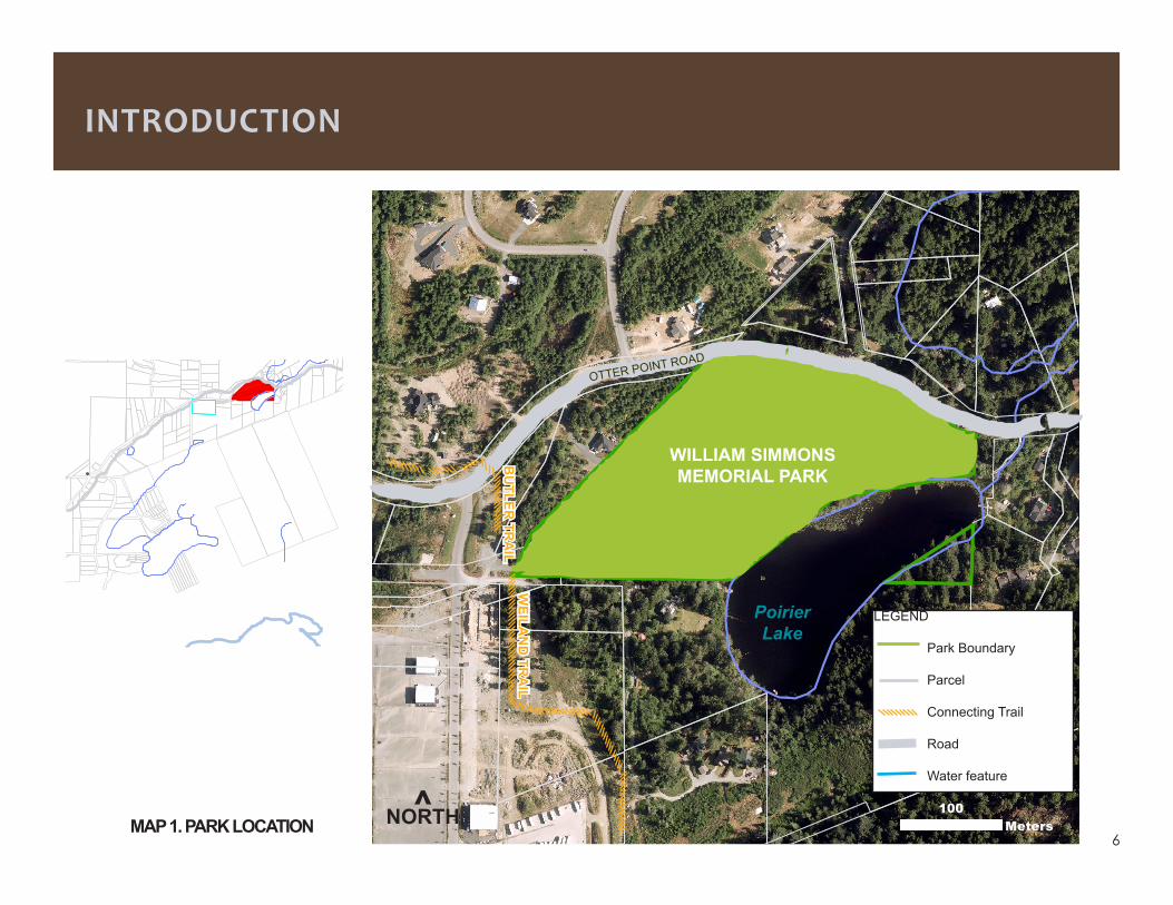
Characteristics of this park type include easy trails appropriate for walking, cycling and equestrian use, picnic shelters, picnic areas, viewing areas, on-site parkingaswellasgroomeduseareas,floralgardensand maintenance of both exotic and endemic plant and fruit tree species.
This park type may also include the following permit-ted structures:
• bikeracks• docks• boateraccessandramps(non-motorized)• openfields• picnicsiteswithbarbecues• interpretivesigns• specialuseareas• equestrianfacilities
ThisrevisedPlanwillfurtherdefineotherappropriateuses and general locations for park infrastructure. This Plan also provides a phased approach for the in-clusion of many of the features suitable for long term user enjoyment of the park.
BACKGROUND
Equestrians are welcome in William Simmons Memmorial Park
9
3.1 PARK DESCRIPTION
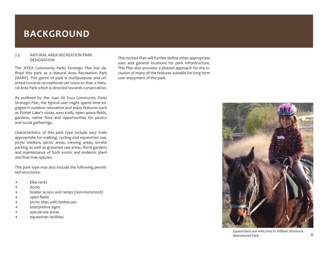
Since the site restoration work of June 2009 and subsequent implementation of the William Simmons Site Management Plan in 2010, most of the initial phases of the Plan’s development strategy have been achieved. Over the past four years, a transformation has taken place that provides a variety of day-use and recreational opportunities for a range of users includ-ing hikers, picnickers, cyclists, equestrians, dog walk-ers and simply those appreciating the amenities and viewscapes of the park.
Entering the day-use area from the Otter Point Road walk-in access, there is a feeling of a planned, yet wild woodland garden that comes to mind. A large boulderdefineswhatwasnotlongagotheonlyparkentry point. A curvilinear flow in the landscape en-tices the visitor to continue onward into the main body of the park. Feeling a sense of intrigue, there is a distant view of Poirier Lake. Park visitors can review their outing at the trailhead kiosk and learn about the park’s permitted activities.
A quaint sense of nostalgia exists around the orchard area as plum and apple trees are once again cared for and provide users with gifts from the past. Sur-rounded by willows and armoured with large rocks to defineitsedges,theseasonalpondisthesecretjewelof the property. Clumps of daisies, lilies, heather and ferns once nurtured, are now allowed to grow wild, adding to the special ambiance of this Natural Area Recreation Park site. Strolling through the lawns and picnic areas amidst the wide range of ornamental, fruit and native trees, an improved view of Poirier Lake is seen over a dense thicket of blackberries, spi-rea and willows.
Poirier Lake looking to south-west
PART 3 EXISTING CONDITIONS
Taking the Panama Rail Trail westward from the view-point, users will experience a winding trail through scenic mature forest. Continuing onward, the trail forks to the rightand leads toanopenfield that isfrequented by horse riders and dog walkers alike. This underused open space area has great potential for future community events and gatherings.
Following the Panama Rail Trail westward will lead to the Butler Road parking area which is currently the only parking area for the park. Another large kiosk
features a park map and related park information. The parking area serves as one of the two access points to the park and is an important junction and starting point for Otter Point’s community trails be-yond. The Butler Trail provides access to the adjacent WoodssubdivisionandtheWielandtrail is identifiedas a future alternative transportation route connect-ing to the greater Otter Point community.
10
3.2 CONNECTING TO COMMUNITY TRAILS AND BEYOND
In concert with the development of the park, the Juan de Fuca Electoral Area Parks and Recreation Advisory Commission has developed a vision that views William Simmons Memorial Park as a connecting hub to other recreational op-portunities in the area. To date this has led to the development of two connect-ing trails from the Butler Road parking area.
The Butler Trail is a 1.25 kilometer trail that connects through The Woods subdi-vision area. The Wieland trail is a longer term project to provide an alternative transportation route for hikers, cyclists and equestrians through the Otter Point community. Working under a Stewardship Agreement with the Juan de Fuca Community Trails Society, this trail currently has 417 meters of developed Type 2 trail, 927 meters of roughed-out trail, and a further 650 meters of planned trail. This initial trail development will provide a safe two kilometer trail from the park to Kemp Lake Road. Over the longer term, it is hoped this trail will continue further through the Otter Point Community, possibly connecting to not only other community parks and trails in the area, but also potentially become part of the future westward extension of the Galloping Goose Regional Trail. Map 2 illustrates William Simmons Memorial Park trails connection to local community trails.
3.3 EXISTING CONDITIONS AND FACILITIES
Since the approval of the Site Management Plan in 2010, a variety of improve-ments to the park have been completed. Map 3 shows existing areas and facili-ties. The following describe these changes and attributes of the park including:
• natural attractions• day use area• trails• park structure• signage• site restoration and improvements• native plant restoration
EXISTING CONDITIONS
Community pedestrian access to the park from Otter Point Road and a viewing bench over Poirier lake.
11
EXISTING CONDITIONS
100Meters
^NORTH
Poirier Lake
BUTLER TRAILW
EILAND TRAIL
OTTER POINT ROAD
PANAMA RAIL TRAIL
MAP 2. PARKS AND CONNECTING TRAILS

12
EXISTING CONDITIONS
MAP 3. EXISTING FACILITIES
Poirier Lake
Day Use Area
PANAMA RAIL TRAIL
Pond
OTTER POINT ROAD
Picnic Shelter
Equestrian Facilities
Open field
Viewpoint
^NORTH
LEGEND Existing Trail
Existing Park Feature Parking/Traihead
Open Space Area
Picnic Area
Orchard
WIELAND TRAIL
BUTLER TRAIL
Trailhead Kiosk
Trailhead Kiosk

13
3.3.1 NATURAL ATTRACTIONS
The natural attractions to William Simmons Memorial Park include opportunities for users to appreciate a variety of ecosystems including riparian, pond, grassy open areas, an orchard, mature forests and Poirier Lake. The photos below show the existing park open space, the riparian shoreline of Poirier Lake, the orchard and a bench overlook-ing “Erik’s” pond.
Localfloraandfaunaconsistofarangeofforesttypes,plantandanimalspecies.Althoughornamentalandnon-invasive,non-indigenousplantsandtreesaretocontinueto be represented in the park, there will continue to be a program to remove invasive species. Such species as scotch broom, holly, gorse, noxious varieties of bamboo and blackberryarebutafewofthespeciesthatshouldcontinuetoberemovedanddisposedoff-site.
EXISTING CONDITIONS
OPEN FIELDS ORCHARD POIRIER LAKE THE POND
14
3.3.2 DAY USE AREA
The 2,700 sq. meter day use area is one of two manicured sites within the park and is accessible from the Otter Point Road walk-in access or from the Panama Rail Trail from the Butler Road parking lot. The day-use areas consists of a picnic shelter/ BBQ area, two separate picnic areas with tables, a natural pond, small orchard and viewpoint area overlooking Poirier Lake. In addition to daily users, this area has become popular for small family events, organized events and weddings. The park is open from sun up until sun down. Camping is not permitted in any community park. Key restrictions and messages are posted at the two main entrance information kiosks.
EXISTING CONDITIONS
DAY USE AREA SHELTER THE POND POIRIER LAKE VIEW POINT WALK-IN ACCESS

15
3.3.3 TRAILS
Theparkhas485metersoftrailsconnectingtheday-useareatotheButlerRoadparkingareaandthemulti-purposedopenfieldinthenorthcentralareaofthepark.Trailconstructionhasfollowedtwotypesoftrailsstandards.TypeOnetrailshaveanaturaltrailsurfaceandtreadwithof1.0–1.5metersandtheTypeTwohasacrusherfinecompacted gravel surface and a tread width of 1.5-2.0 meters. Both trail types are designed to accommodate hikers, cyclists and horse use. Type Two standards are typically usedwheretrafficisanticipatedtobehighorwhereamoredurabletrailisrequiredtoaddressfloodingorhighimpactareas.TheTrailsStandardscanbefoundinAppendixA.
EXISTING CONDITIONS
TRAIL SIGNAGE WALK-IN ACCESS (DAY-USE AREA) PANAMA RAIL TRAIL DAY USE AREA SURFACED TRAIL

16
3.3.4 PARK STRUCTURES
To enhance the visitor use and experience a number of structures have been developed since 2010. These include:
• An all season picnic shelter that can accommodate 12-15 people that can be used in conjunction with other activities in the day-use area;• Trailhead information kiosks and notice boards at the two access points to the park;• AparkingareaatthejunctionofDenfieldandButlerRoads,forbothvehiclesandhorsetrailers;• Picnictablesandbenchesintheday-useareaandopenfield;• Fencing to enhance visual appearance and safety needs• Hitchingrailandmanurebinforequestrianusersintheopenfieldarea.
PICNIC TABLES FENCING MANURE STORAGE AREA PICNIC SHELTER
EXISTING CONDITIONS
17
3.3.5 SIGNAGE
Acomprehensivesignplanwasdesignedandimplementedwhichincluded:parkentranceandinformationkiosksigns;trailpostsandway-findingsignstoandfromtheparkingandday-usearea;parkboundarysignsalongsectionsofadjoiningproperties;prohibitionssigns(nocamping,nofires,nomotorizedvehicles);hazardwildlifecautionsigns and Fisheries and Oceans Canada information signs. The two information kiosks are also available for local (non-business advertisements) notices.
REGULATORY SIGNAGE WAYFINDING SIGNAGE REGULARTORY SIGNAGE ORIENTATION SIGNAGE
EXISTING CONDITIONS
18
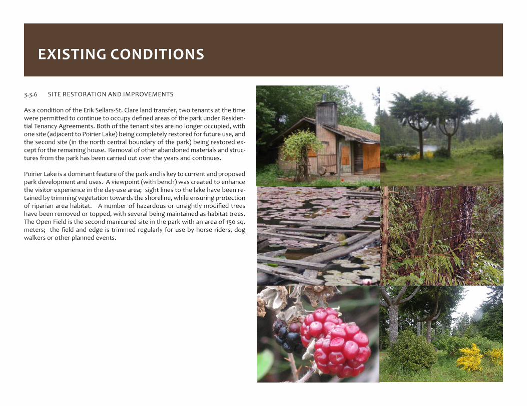
3.3.6 SITE RESTORATION AND IMPROVEMENTS
As a condition of the Erik Sellars-St. Clare land transfer, two tenants at the time werepermittedtocontinuetooccupydefinedareasoftheparkunderResiden-tial Tenancy Agreements. Both of the tenant sites are no longer occupied, with one site (adjacent to Poirier Lake) being completely restored for future use, and the second site (in the north central boundary of the park) being restored ex-cept for the remaining house. Removal of other abandoned materials and struc-tures from the park has been carried out over the years and continues.
Poirier Lake is a dominant feature of the park and is key to current and proposed park development and uses. A viewpoint (with bench) was created to enhance the visitor experience in the day-use area; sight lines to the lake have been re-tained by trimming vegetation towards the shoreline, while ensuring protection ofriparianareahabitat. Anumberofhazardousorunsightlymodifiedtreeshave been removed or topped, with several being maintained as habitat trees. The Open Field is the second manicured site in the park with an area of 150 sq. meters; thefieldandedge is trimmed regularly forusebyhorse riders,dogwalkers or other planned events.
EXISTING CONDITIONS

19
3.3.7 NATIVE PLANT RESTORATION
William Simmons Memorial Park has had a colourful past as far as botany is concerned. The site’s former residents created a disturbed site where invasive plants have taken hold and monocultures of plants have adapted quickly to the newgrowingconditionsfoundonsite.EventhenativeDouglasfirweremostlyplanted by past residents (H. Phillips).
In 2012, a restoration project was initiated by a group of local volunteers The Native Plant Restoration Project aims to enhance the diversity of native plants in the park.
Oneaspectoftheprojectistofindplantingsitesawayfromthetrailswherena-tive plants can be installed or seeded to grow and reproduce without impacts from surrounding uses. The plants require pollinators to set seed, making the natural environment a more productive seed location than in greenhouses. If there are plant diseases in the soil or chemicals the plants won’t tolerate, the area won’t support the new plants. Observations based on existing growth in an area will be followed with the experiment of seeing what other plants will succeed in a particular niche (source: Native Plant Restoration Project).
This is a long term project since the varieties that are not growing in the park already are likely plants that don’t compete well with other plants, have special- ized needs or take a while to establish. Table 1 is a list of plants that have been plantedand/orareidentifiedinthepark.
TABLE 1. NATIVE PLANTS FOUND AT WILLIAM SIMMONS MEMORIAL PARK
IDENTIFIED PLANTS PLANTED PLANTS
baldhip rose bog St John’s-wortcolumbia lily deer fern
evergreen violet nodding onionPacificbleedingheart Pacificwaterleaf
red columbine redfloweringcurrantSaskatoon spiny wood fern
trillium tall blue camastallmonkeyflower,
trailing black currant
yellow eyed grass
yellow stream violet
youth-on-age
source: Native Plant Restoration Project
EXISTING CONDITIONS

20
In the original 2010 version of the Site Management Plan, a future Phase 3 Park Developmentareawasidentified.Thisisthefocusofthenextphaseofdevel-opment for the park, however, the Plan will also include new developments in other areas of the park.
4.1 POIRIER LAKE DEVELOPMENT AREA
With the recent restoration of the former tenant site, future park development will now focus on providing access to recreational opportunities on Poirier Lake, as well as improved access to the adjacent day-use area and facilities.
4.1.1 RECREATIONAL FISHING/STOCKING BACKGROUND
PoirierLakeprovidessuitablefishhabitatfortroutandotherfishfishspecies.Poirier Lake is a public lake that measures 7.5 acres in surface area (see Appen-dix B for bathymetric map) and has been used by local residents for many years. Fromarecreationalfishingperspective,historicallythislakehasseenveryfewanglers.Thisislikelytonotonlythegenerallackoffishinthelake,butbecauseof private land ownership in the past, the only public access to the lake was via a 35 meter long and narrow 1-2 meter wide path within a Ministry of Transporta-tionandInfrastructureforeshoreaccessoffOtterPointRoad.Therewasalsonolaunchorfacilitiesonsitethatcouldhaveassistedaccessforfishing.
In 1989, the lake was stocked with steelhead from the Sooke River Hatchery. In the 2014 lake survey carried out by the Ministry of Forests, Lands and Natu-ralResourceOperations(MFLNRO),twocutthroattroutwereidentified.Giventhatthisspecieswasnotidentifiedinanypreviouswork,theirpresenceissuspi-cious. Previous stocking information is provided on Table 2.
In the spring of 2014, during peak amphibian breeding egg laying season, an amphibiousassessmentwasalsocompletedbyMFLNROstaff.Resultsindicatedlow habitat values for amphibians in Poirier Lake mainly as a result of a lack of vegetation found in the lake. The number of amphibian egg masses counted wasconsideredverylowforthelake,confirmingthelowhabitatvalues.
TABLE 2. FISH SPECIES FOUND IN POIRIER LAKESTOCKED LAKE ASSESSMENT RESULTS
STEELHEAD (1673RELEASEDIN1989)
CUTTHROATTROUT(-2014)
RAINBOWTROUT(1982)PRICKLYSCULPIN(1952,1980,
1982)BROWNCATFISH(1980,1952)
PART 4 NEW DEVELOPMENTS
21
NEW DEVELOPMENTS
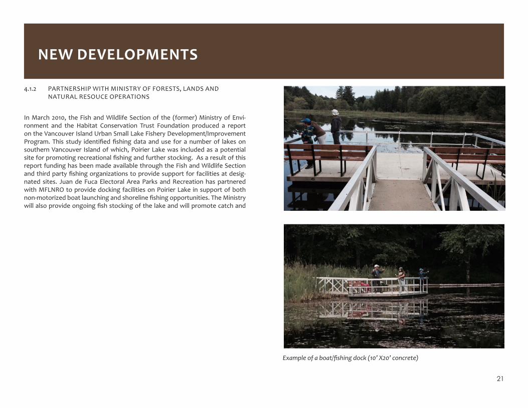
Example of a boat/fishing dock (10’ X20’ concrete)
4.1.2 PARTNERSHIP WITH MINISTRY OF FORESTS, LANDS AND NATURAL RESOUCE OPERATIONS
In March 2010, the Fish and Wildlife Section of the (former) Ministry of Envi-ronment and the Habitat Conservation Trust Foundation produced a report on the Vancouver Island Urban Small Lake Fishery Development/Improvement Program.This study identifiedfishingdataanduse foranumberof lakesonsouthern Vancouver Island of which, Poirier Lake was included as a potential siteforpromotingrecreationalfishingandfurtherstocking.Asaresultofthisreport funding has been made available through the Fish and Wildlife Section andthirdpartyfishingorganizationstoprovidesupportforfacilitiesatdesig-nated sites. Juan de Fuca Electoral Area Parks and Recreation has partnered with MFLNRO to provide docking facilities on Poirier Lake in support of both non-motorizedboatlaunchingandshorelinefishingopportunities.TheMinistrywillalsoprovideongoingfishstockingofthelakeandwillpromotecatchand
22
4.1.3 PROPOSED DEVELOPMENT PLAN
Map 4 illustrates the location and types of improvements for the Poirier Lake Development Area. The improvements will consist of the following:
• Continue restoration activities in the former tenant site;
• ConstructagravelaccessroadoffOtterPointRoadandparkinglotthatwill
support up to 8 vehicles;
• Develop a Type 2 access trail (2 meters wide) from the parking area to
Poirier Lake boat dock area;
• Constructa6-8meterwalk-outcribintoPoirierLaketoasufficientdepth
thatenablesinstallationofafloatingdock;
• Installalowprofile10’x20’floatingconcretedockforlaunchingsmallnon-
motorized boats (see photos on page 21);
• Installasecondlowprofile10’x20’concretedockonthesouth-westsideof
thelaketoaccommodateshorelinerecreationalfishingaccesstothisdock;
• ConstructaType2connectingtrailoffthePanamaRailTrailtothefishing
dock;
• Construct a Type 2 trail (1.5 meters wide) from the parking area, connecting
to the Day-Use area;
• Landscape selected sections of the development area to enhance views of
the lake and accommodate a picnic/viewing area;
• Install split rail fencing along back of parking area to prevent unauthorized
secondary trails to day-use area;
• Restrict lake use to only small non-motorized boats, canoe and kayak use;
• Promotecatchandreleaseasapreferredrecreationalfishingexperience;
• Due to a soft lake bottom and considerable dangerous submerged debris,
discourage swimming along the park shoreline;
• Where practical, remove abandoned materials and safety hazards from the
shoreline areas of the park;
• Promote a policy of pack-in and pack-out for all garbage;
• Provide information, safety and regulatory signs as required.
NEW DEVELOPMENTS

23
NEW DEVELOPMENTS
MAP 4. NEW DEVELOPMENT AREAS
^NORTHOTTER POINT ROAD
Poirier Lake
Day Use Area
Viewpoint Picnic Area
MO
TI F
ores
hore
Acc
ess
(fut
ure
park
ing
area
)
Parking Area for 8 vehicles
PANAMA RAIL TRAIL
New Trail
Fishing Dock10’x20’
Boat Dock10’x20’
Equestrian Facilities Picnic
Shelter
Access to day use area
Open field
LEGEND
New Trail
Existing Trail
Proposed Fencing
Existing Park Feature
Parking Area
Open Space Area
Picnic Area
24
release practices.
4.2 OTHER PARK IMPROVEMENTS AND OBJECTIVES
Mostofthe improvements identified inthe2010SiteManagementPlanhavebeen accomplished, but there are additional improvements that can be carried out that can enhance current and future uses of the park. The following im-provementshavebeenidentified:
4.2.1 NEW AND IMPROVED TRAILS
A new 50 meter trail (Type 2 standard) will be constructed from the mid-section ofthePanamaRailTrail tothesiteofthefishingdockatthesouth-westendof the park shoreline. Sections of the Panama Rail Trail from the Day-Use Area totheopenfieldarearequireupgradingofthetreadsurfacetotheType1trailstandard. Over time, the objective will be to develop and improve all trails with-in the park to ensure handicap access.
4.2.2 WASHROOM FACILITY
The visitors currently frequenting the park are largely local residents, but levels of use are increasing, as is interest in the park for more organized events from both local and other communities. The construction of a permanent vault type washroom facility is expensive and not warranted at this time. As an interim step, a seasonal portable toilet site will be developed in the day-use area.
4.2.3 RESTORATION OF FORMER TENANT SITE
The former tenant site at the north-western boundary of the park has under-gonesignificantrestorationwork,butthehousestillremains.Thisfinalstageofrestoration of the site will occur once funding is in place. There are currently no plans for access and use of this area and it will otherwise be allowed to naturally regenerate.
4.2.4 IMPROVEMENTSTODAY-USEAREA
The small gravel area next to the picnic shelter was designed for portable BBQ use. This BBQ area will be replaced with a concrete pad and potentially one or two stand pipe style charcoal BBQs. There are additional opportunities for one ortwobenchlocationswithintheday-useareathataffordexcellentviewsofPoirier Lake.
4.2.5 INTERPRETIVE SIGNS
At present there are no interpretive displays in the park. These could include historical information on the park area as well as descriptions of the natural features of the park and such initiatives as volunteer plant restoration work. Displays could be developed at strategic locations as well as the inside of the picnic shelter.
William Simmons Park and Poirier Lake have several environmenal and safety issues that should be considered before further development of the lake or park take place in the future.
4.2.6 BIKE RACKBased on recommendations from the consultation process, a bike rack will be provided in the Day-Use area.
4.2.7 FUTURE NATURAL DESIGN PLAYGROUND AREA
Several respondents to the consultation questionnaire indicated support for a children playground in the park. This will be given consideration in potential future development in the park. Given costs, most new playground developments are now using natural materials in their design, which is most appropriate for this park. The Open Field area would likely be the preferred location of any such future development.William Simmons Memorial Park and Poirier Lake have several environmental
NEW DEVELOPMENTS

25
PART 5 SAFETY AND ENVIRONMENTAL CONSIDERATIONS
and safety issues that should be considered before further development of the lake or pakr take place in the future.
5.1 SWIMMING(POIRIERLAKESHORELINE)
Although Poirier Lake is a public lake, the shoreline area of the park (particularly around the site of the boat dock) is shallow and has a soft, deep bottom (refer to Appendix B). As well, considerable log debris and other potential hazards are common along the shoreline. Because of these hazards, swimming will be discouraged along the park shoreline and signs will be posted accordingly. Al-thoughthefishingdockwillbe located indeeperwater, it isnot intendedtobe used as a swimming platform and will have high railings to discourage this activity.
5.2 NON-MOTORIZEDBOATINGINPOIRIERLAKE
Poirier Lake is a relatively small lake. In order to minimize the risk of water pollu-tionandensureaquietenvironmentforfishing,otherusergroupsandadjacentproperty owners, signage will be located at the boat launch dock to seek volun-tary compliance to avoid the use of gas powered motors. If voluntary compli-ance is not successful, the CRD will seek a formal restriction on gas powered motors through Transport Canada.
5.3 HAZARDOUSTREES
On a regular basis, trees within and adjacent to trails and activity areas will be assessed for potential hazards. This may involve limbing, topping or removal depending on the nature of the hazard. Where practical, some trees may be retained as nature or habitat trees.
5.4 WALK-INACCESSTODAY-USEAREA(OTTERPOINTROAD)
Theprimaryparkingareaforthepark is locatedoffButlerRoad intheSookeBusiness Park. A second parking area is proposed for the Poirier Lake access and development area which will also provide trail access into the adjacent day-use area.Thewalk-inaccesstotheday-useareaoffOtterPointRoadisnottobeused for public parking due to hazards associated with limited sight lines along
Otter Point Road. This area is signed for No Parking, with access into the day-use-area being restricted to maintenance and emergency vehicle needs or for unloadingforone-timeeventswheretrafficcontrolmeasuresareinplace.
5.5 HIGHWAY AND PARK SIGNS
Warning “Vehicle Turning” signs will be required on Otter Point Road on either side of the access road into the New Development parking area. Additional safety or regulatory signs will be provided informing visitors of hazards or re-strictions in the new development areas.
Remnants of old dock poses a hazard to humans and animals

26
Implementation of the updated William Simmons Memorial Park Site Management Plan will commence in 2015. As in the past, achieving the goals set out in the Plan will be dependent on funding availability at the time and may require several years to complete. Application to the Union of British Columbia Municipalities Gas Tax Fund will also be sought in order to help fund the implementation of the Plan. Table 3 outlines phasing and improvements for the park.
TABLE 3 PRIORITY PARK IMPROVEMENTS
POIRIER LAKE DEVELOPMENT AREA COMMENTS
GravelAccessRoadoffOtterPointRoad Improve existing access road
Construct gravel parking area Accommodate up to 8 vehicles
Construct Access Trail and Crib Jetty 1.5 meters wide Access to lake and New Dock
Install Concrete Boat Launch Dock Purchase/Installment funded by MFLNRO
Install Concrete Fishing Dock SW end of Poirier Lake in deeper water
Construct New Trails to Day Use Area Connect access from lake parking area
Construct New Trails to Fishing Dock 50 meter trail; Type 2 trail standard
Continue cleanup and restoration of site Former tenant site
Commence stocking of lake with cut throat trout
MFLNRO
Install information, safety and regula-tory signs
Otter Point Road, development area
PART 6 PHASING PLAN
Landscape and maintain facility areas Mowing/trimming use areas
Maintain & harvest fruit trees and orna-mental plants
Periodic pruning.Support local food banks
OTHER PARK IMPROVEMENTS COMMENTS
Install Seasonal Toilet Day-Use Area
Improve existing trails Panama Rail Trail
Additional picnic tables, benches Various locations as needed
Improve Poirier Lake Viewscapes Trim vegetation to maintain sight lines
Continue Plant Restoration Program Additional propagation sites, species
Install split rail fencing to designate areas
Trafficflow,aesthetics,closedtrails
Continue invasive species removal On-going program
Decommission former tenant structure in north central area of park
As funding permits
Provide bke rack Day use area
Provide Interpretive signs Historical and ecological information
Continue developing external trail networks
Ongoing trail development connecting to park
27
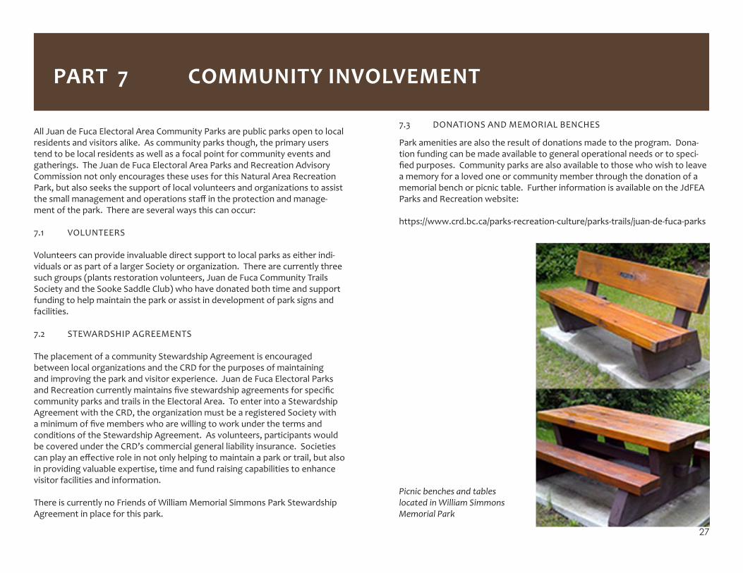
7.3 DONATIONS AND MEMORIAL BENCHES
Park amenities are also the result of donations made to the program. Dona-tion funding can be made available to general operational needs or to speci-fiedpurposes.Communityparksarealsoavailabletothosewhowishtoleavea memory for a loved one or community member through the donation of a memorial bench or picnic table. Further information is available on the JdFEA Parks and Recreation website:
https://www.crd.bc.ca/parks-recreation-culture/parks-trails/juan-de-fuca-parks
Picnic benches and tables located in William Simmons Memorial Park
All Juan de Fuca Electoral Area Community Parks are public parks open to local residents and visitors alike. As community parks though, the primary users tend to be local residents as well as a focal point for community events and gatherings. The Juan de Fuca Electoral Area Parks and Recreation Advisory Commission not only encourages these uses for this Natural Area Recreation Park, but also seeks the support of local volunteers and organizations to assist thesmallmanagementandoperationsstaffintheprotectionandmanage-ment of the park. There are several ways this can occur:
7.1 VOLUNTEERS
Volunteers can provide invaluable direct support to local parks as either indi-viduals or as part of a larger Society or organization. There are currently three such groups (plants restoration volunteers, Juan de Fuca Community Trails Society and the Sooke Saddle Club) who have donated both time and support funding to help maintain the park or assist in development of park signs and facilities.
7.2 STEWARDSHIP AGREEMENTS
The placement of a community Stewardship Agreement is encouraged between local organizations and the CRD for the purposes of maintaining and improving the park and visitor experience. Juan de Fuca Electoral Parks andRecreationcurrentlymaintainsfivestewardshipagreementsforspecificcommunity parks and trails in the Electoral Area. To enter into a Stewardship Agreement with the CRD, the organization must be a registered Society with aminimumoffivememberswhoarewillingtoworkunderthetermsandconditions of the Stewardship Agreement. As volunteers, participants would be covered under the CRD’s commercial general liability insurance. Societies canplayaneffectiveroleinnotonlyhelpingtomaintainaparkortrail,butalsoin providing valuable expertise, time and fund raising capabilities to enhance visitor facilities and information.
There is currently no Friends of William Memorial Simmons Park Stewardship Agreement in place for this park.
PART 7 COMMUNITY INVOLVEMENT
28
PART 8 SOURCES
Capital Regional DistrictOtterPointOfficialCommunityPlan,2008, 2014
Capital Regional District Draft JDFEA Community Parks Strategic Plan, 2010
Cooper Marcus, Clare and Caorlyn Francis. People Places: Design Guidelines for Urban Open Space, 1998
Capital Regional District Quarterly Building Permit Report, 2009
Fowler, Floyd J. Jr. Survey Research Methods. 2nd ed. Newbury Park. CA: Sage Publications, 1993.
Hellmund P.C. Planning Trails with Wildlife in Mind. A Handbook for Trail Planners. Denver, Colorado State Parks, 1998.
International Mountain Bike Association. Trail Solutions: IMBA’s Guide to Building Sweet Singletrack. IMBA, 2005
International Mountain Bike Association. Managing Mountain Biking. IMBAs Guide to Providing Great Mountain Biking.IMBA, 2007
JE Anderson & Associates Denfield Rd Site Survey, 2009
Kehler, Michelle Vancouver Island Urban Small Lake Fishery Development/Improvement Program, 2010
Ontario Trail Riders Association http://www.otra.ca
Otter Point and Shirley Resident Ratepayers Association. http://opsrra.ca/index.htm
Silvestri, Scott. Kemp Lake Angling and Lake Infrastructure Improvement Proposal. Ministry of Environment, Enviromental Stewardship Division. 2010
29
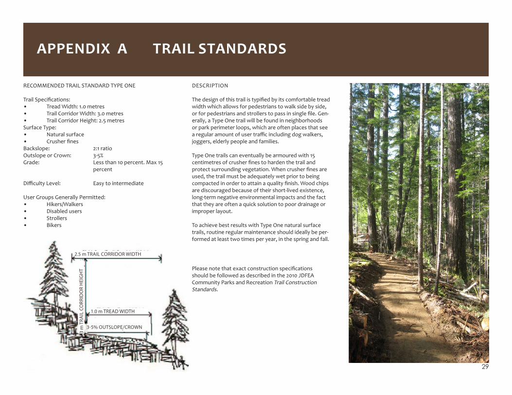
DESCRIPTION
Thedesignofthistrailistypifiedbyitscomfortabletreadwidth which allows for pedestrians to walk side by side, orforpedestriansandstrollerstopassinsinglefile.Gen-erally, a Type One trail will be found in neighborhoods or park perimeter loops, which are often places that see aregularamountofusertrafficincludingdogwalkers,joggers, elderly people and families.
Type One trails can eventually be armoured with 15 centimetresofcrusherfinestohardenthetrailandprotectsurroundingvegetation.Whencrusherfinesareused, the trail must be adequately wet prior to being compactedinordertoattainaqualityfinish.Woodchipsare discouraged because of their short-lived existence, long-term negative environmental impacts and the fact that they are often a quick solution to poor drainage or improper layout.
To achieve best results with Type One natural surface trails, routine regular maintenance should ideally be per-formed at least two times per year, in the spring and fall.
RECOMMENDED TRAIL STANDARD TYPE ONE
TrailSpecifications:• Tread Width: 1.0 metres• Trail Corridor Width: 3.0 metres• Trail Corridor Height: 2.5 metresSurface Type:• Natural surface• CrusherfinesBackslope: 2:1 ratioOutslope or Crown: 3-5%Grade: Less than 10 percent. Max 15 percent
DifficultyLevel: Easytointermediate
User Groups Generally Permitted:• Hikers/Walkers• Disabled users• Strollers• Bikers
2.5 m TRAIL CORRIDOR WIDTH
3 m
TRA
IL C
ORR
IDO
R H
EIG
HT
1.0 m TREAD WIDTH
3-5% OUTSLOPE/CROWN
Pleasenotethatexactconstructionspecificationsshould be followed as described in the 2010 JDFEA Community Parks and Recreation Trail Construction Standards.
APPENDIX A TRAIL STANDARDS

30
DESCRIPTION
Type Two trails are multi-use trails designed for shallow grades (not to exceed 10 percent) Type Two trails aim to linkcommunitiesandprovidetheuserwithanoff-roadexperience where daily life and the natural character-istics of the park can be observed. These trails can be armouredwith15centimetresofcrusherfinestohardenthe trail and protect surrounding vegetation from the impactsofheavytraffic.Whencrusherfinesareused,thefinesmustmaintainthreetosixpercentmoisturecontent in order to attain 98% compaction. Wood chips are discouraged because of their short-lived existence, long-term negative environmental impacts and the fact that they are often a short-term solution to poor drain-age or improper layout.
To achieve best results with Type Two or crushed surface trails, routine regular maintenance should be performed at least two times per year, ideally taking place in the spring and fall.
RECOMMENDED TRAIL STANDARD TYPE TWO
TrailSpecifications:• Tread Width: 1.5 metres• Trail Corridor Width: 3.0 metres• Trail Corridor Height: 3.0 metresSurface Type:• Natural surface• CrusherfinesBackslope: 2:1 ratioOutslope or Crown: 3-5%Grade: Less than 10 percent
DifficultyLevel: Easytointermediate
User Groups Permitted:• Hikers/Walkers• Bikers• Disabled Users• Strollers• Horses
3.0 m TRAIL CORRIDOR WIDTH
3.0
m T
RAIL
CO
RRID
OR
HEI
GH
T
1.5.m TREAD WIDTH
3-5% OUTSLOPE/CROWN
Pleasenotethatexactconstructionspecificationsshouldbe followed as described in the 2010 JDFEA Community Parks and Recreation Trail Construction Standards.

31
APPENDIX B BATHYMETRIC MAP FOR POIRIER LAKE