Embed Size (px)
Citation preview
L
BY
WILLIAM J. MITSchool of Natural Resources, The Ohio
2021 Coffey Road, Columbus, OR
1994
ELSEVIER
Amsterdam, Lausanne, New York, Oxford, Shannon, Tokyo
Global Wetlands: Old World and NewEdited W.J. Mitsch© 1994 Elsevier Science B.V. All reserved.
M.M. UlY·..... Cfiln w.
USA
,,.,v,,l·nn·n MS 39180,
lBiology Department, East Carolina University, ur'eeJ'1Vlue.
Environmental Research
Lee and Associates, Inc., 221 1st Avenue West, Suite 415, Seattle,
4School of Forest Resources, of Georgia, Athens, GA
US Waterways Experiment Station,
USA
6Smithsonian Environmental Research Center, Route 4, Box 622, f1no"'lAJrl;t",r
Abstract
We present a five-step proposal for developing an approach to assess the functions of wetland ecosystems.step is to classify wetlands based on hydrogeomorphic (HGM) properties. The are gec)m()rpJhic
the sources of water the wetland, and the hydrodynamics of water within the wetland.grouping wetlands into HGM classes with shared properties, assessments can be tailored to address the functionsrelevant to each HGM class. Step two is to define the relationship between HGM properties and the functions; theto select functions that are linked, clearly and logically, to wetland HGM properties, and that have hydrologic, gec)m()rpllic,and ecological significance on site or off site. This step is critical because it represents the scientific basis for the presenceof the function. The linkage between HGM properties and wetland functions can be improved with new researchThe third step is to develop functional profiles for each wetland class. Profiles can range from narrative ofa single site to detailed multivariate data sets for numerous sites. The fourth step is to a scale for eX1Jfe1~SlIlg
functions by using indicators and profiles from the reference wetlands; these must be for each wetlandclass in order to serve as benchmarks for the HGM classes. Reference wetlands should include the full rangenatural and human-induced variations due to stress and disturbance. The final step is to the assessmentmethodology itself. The assessment relies on indicators to reveal the likelihood that the functions evaluated arepresent in the wetland and depends upon reference populations to scale the assessment. Reference wetlands are criticalalso to the setting of goals for compensatory mitigation. The task of goal-setting is because referencewetlands become a standard for which goals can be chosen and success can be measured.
INTRODUCTION
V'>.'UA,'c>V of this paper is the assessment ofthe procedure into discrete steps. we
the assessment as a whole. The assessment was npup'!"r\pn
T"lr'''",(llTlIlT a tool for wetland regulatory programs in the United States. HAUl"""P..
inherent in the approach that limits its use to the United States or tois anticipated that it will be useful in any in context of plamnlnj;;, ITlanlagemlent,
616 M.M. BRINSON ET AL.
educational, or regulatory activities involving wetland resources. A parallel effort is being developed inEurope by an international team (Maltby et al., 1994).
The approach is being developed as part of an ongoing project supported under the WetlandsResearch Program at the US Army Engineer Waterways Experiment Station. A conceptual andorganizational framework for the project is described in a report by Smith (1993). Development ofthe approach was initiated in 1991 at a workshop attended by approximately 40 scientists whodiscussed various alternatives for assessing the functions of wetlands. One of the alternativesdiscussed was based on the fundamental hydrogeomorphic (HGM) properties of wetlands. Theeventual outcome of these discussions was a HGM classification of wetlands (Brinson, 1993a) thatserves as the basis for the present assessment approach. This paper focuses on the philosophy andrationale for the assessment approach rather than the mechanics of an assessment method forimplementing the approach. Fundamental to this rationale is the use of "reference wetlands" whichrepresent a collection of sites of a specific wetland class that can be used for developing the upperand lower boundaries of functioning within the class.
The five steps in the assessment approach are to: (1) classify wetlands according to HGMproperties, (2) make connections between the properties of each wetland class and the ecologicalfunctions that they perform based on logic and research results, (3) develop functional profiles foreach wetland class, (4) choose reference wetlands that represent the range of both natural andhuman-imposed stresses and disturbances, and (5) design the assessment method using indicatorscalibrated to reference wetlands. Each step is discussed below.
THE ASSESSMENT APPROACH
1: Classifying Wetlands Based on Hydrogeomorphic Properties
In the context of assessing the functioning of wetlands, the purpose of classifying them is toidentify wetland groups that exhibit a relatively narrow range of variation in the properties thatfundamentally influence how wetlands function. Narrowing the range of variation makes the task ofdeveloping assessment methods more manageable, and significantly reduces the time and effortrequired to conduct an assessment.
The HGM classification (Brinson, 1993a) uses first principles of geomorphology, hydrology,and hydrodynamics to separate wetlands into functional classes at a gross level, and serves as anorganizing principle for the development of an assessment method. As with any classification thereis the need to strike a balance between what is considered too general to provide useful information,or too specific to allow broad application on a national or regional scale. In this respect, the HGMclassification is hierarchical and modular so it can be easily modified for different geographicregions or scales.
Four broad geomorphic settings are recognized in the classification: riverine, depressional, fringe(coastal), and extensive peatlands. Wetlands may potentially receive three sources of water: precipitation, overland flow, and groundwater discharge. Three hydrodynamic categories embody thestrength and principal directions of flow: vertical fluctuation, unidirectional horizontal flow, andbidirectional horizontal flow. While the number of variables in the classification may seem daunting,the classification procedure can be condensed into simple narrative statem~nts. For example,"Wetland 'A' is classified as depressional, lacks channeled inflows and outflows, and dependsprimarily on snowmelt within its small drainage basin for site water balance during the growing
AN APPROACH FOR ASSESSING THE FUNCTIONS OF WETLANDS
season". This description provides the essence of a limited range of wetlandsgiving useful specific information on water sources and hydrodynamics. In ......,.,.,.,. ..",""wetlands are to be developed (Step 3) in order to supply more detailed descriptions and qmmtItatldata to characterize each wetland class.
Step 2: Defining the Relationship Between Hydrogeomorphic Properties and the FunctionsWetlands
The traditional approach to assessing the functions of wetlands is to with a generic list ofwetland functions (Conservation Foundation, 1988; Larson and Mazzarese, 1994) and then look forevidence that the wetland under consideration does indeed perform the functions. For example, if awetland has permanent standing water, is connected to a larger body of water, and has interspersion ofboth emergent and submerged vegetation, it will likely support fish and thus bedetermined to have a high probability of aquatic food web support. This approach has severalproblems not the least of which is its inefficiency owing to the fact that each assessed wetlandmust be tested against the full range of conditions that potentially occurs in all wetland classes.However, more importantly, a generic series of questions fails to explicitly define the ..""I·"hr"'.,".. lh .....
between properties of the wetland and the functions it is supposed to be performing. This 'black box'approach makes it difficult for the user to understand, learn from, or question the assumedrelationships between wetland properties and functions. In fact, such procedures can be appliedwithout ever acknowledging the wetland class and associated attributes.
An alternative approach is to logically induce which functions a wetland is likely to performexamining hydrogeomorphic and other fundamental properties. A great deal of information abouthow a wetland functions can be derived from knowing the source of the water supplying a welt1anldand the climatic conditions in which it exists. For example, in mesic climates where the dominantwater source of a wetland may be overbank flooding, a wetland is likely to provide """141 ........."",....1
retention and rapid biogeochemical cycling because sediments and nutrients are carried to thewetland surface from the stream channel by overbank flooding. Table 1 provides more ofthis procedure from the HGM classification (Brinson, 1993a), and illustrates them for severalcommonly occurring combinations of climatic setting and water source. For each of these combinations, probable functions are identified in Table 1, Column 4 along with the rationalethe wetland is likely to perform the function. Of course in actual practice, the brief statements inTable I can be expanded by developing supplemental information along with literature citations ofrelevant studies.
The open and explicit nature of this approach has several benefits. the sequence oflinking fundamental properties with functions encourages the user to learn and understand relationships between ecosystem properties and function. Another benefit is the scientificthrough an open process of peer review of the assessment itself. The effectively thwartsany tendency to assume that a function exists when, in fact, it may not, attribute functioningwhen documentation of its presence is scanty or lacking. By the logic and tracing theorigin of functions, the assessment procedure is open for review and through incorpo-ration of new scientific evidence, and the addition or deletion functions. Additionally, there can beno hidden agenda in the assessment if it is open for modification and peer review. This reduces thepotential for misuse.
Extensive data sets are not necessary to establish the between fundamental proper-ties of a wetland and the functions it performs. With the establishment of reference wetlands (Step
618 M.M. BRINSON ET AL.
3, in which functions have already been evaluated, the site being evaluated is compared to thereference group of the same class. This avoids the need to establish an arbitrary scale for ranking;the scale is defined by the variation within the reference population itself. In other cases, the simple
of cause and effect is sufficient to establish the presence or absence of specific functions. Forexample: Why are floodplain wetlands important to riverine fish populations? Reasons mightinclude that seasonal flooding of the wetland allows fish to move from the channel to the floodplainwetland for feeding, spawning, and predator avoidance. Many wetlands lack this property. Whycan't ombrotrophic bogs act as traps for fluvial sources of sediment? Because their water sourcecomes only from precipitation which is devoid of fluvial sediments. Other wetland classes mayreceive loadings of sediments from more than one source. Why do estuarine fringe wetlands exhibitsuch strong zonation? Because twice daily tides serve as an organizing force. For this reason,successful creation of wetlands in tidal environments must have accurately controlled surfaceelevations. Although each of these answers is self evident, there is a tendency to skip over thesefundamentals that may require explanation and documentation should the assessment be challenged.
Step 3: Developing Functional ProfilesOnce the connection between hydrogeomorphic properties and functions of wetlands has been
established, the significance of functioning can be articulated from ecological, hydrological, andother perspectives. These perspectives can be summarized in "functional profiles" for wetlands thathave been assessed. A functional profile is a body of descriptive information that characterizes afunctional wetland class or a single wetland. For example, wetlands that provide sediment retentionand rapid biogeochemical cycling are ecologically significant because they help to maintain highprimary productivity and complex habitat structure of the wetland ecosystem (Table 1, Rowbeginning with "overland (surface) transport", Column 5).
The availability of time, resources, and information will limit the completeness of functionalprofiles for both classes and specific sites. At minimum, one must develop a profile on a smallreference population as a basis for the scaling of functions within a class (see next step), but also theprofile must provide the basis for comparison between the reference population and a new siteundergoing assessment. With continued progress and experience in conducting assessments, theinformation collected during the assessment procedure can become a significant database on soils,
species, hydrology, topography, and other information for a particular HGM class. By'-'V.LUL'~UllUh this information with what can be gleaned from the literature, a more comprehensivefunctional profile could be developed for HGM wetland classes within a specific locality or region.For one riparian forest site in an arid region may have been studied for bird habitat, anotherfor sediment retention, and yet another for flood-water storage. By combining the informa,ti.op froma number of field sites representative of a wetland class, it is possible to develop a compositefunctional much like the community profiles that the U.S. Fish and Wildlife Service haspublished for many wetland ecosystems such as mangroves (Odum et aI., 1982), pocosins (Sharitzand Gibbons, Atlantic white cedar swamps (Laderman, 1989), irregularly flooded saltmarshes (Stout, 1984), tidal freshwater marshes (Odum et aI., 1984), tidal marshes of PacificNorthwest (Seliskar and Gallagher, 1983), prairie basin wetlands, (Kantrud et aI., 1989), and others.
Step 4: Developing Function Using Reference WetlandsDetermining where a specific wetland falls along the scale of function requires a method for
estimating or quantifying the properties of the wetland that determine how it functions. The abilityto identify the position of a wetland on a scale of functioning is difficult but fundamental. In contrast
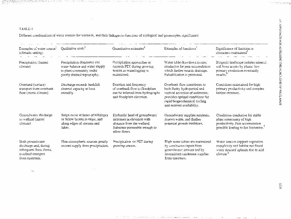
TABLE 1
Different combinations of water sources for wetlands, and their linkages to functions of ecological and geomorphic significance
:>z:>'"0'"0;;0o:>(]:c
Examples of water source l
(climatic setting)
Precipitation (humidclimate)
Overland (surface)transport from overbankflow (mesic climate)
Groundwater dischargeto wetland (mesicclimate)
Both groundwaterdischarge and, duringinfrequent flood flows,overland transportfrom upstream.
Qualitative scale2
Precipitation dominates sitewater balance and water supplyto plant community underpoorly drained topography.
Discharge exceeds bankfullchannel capacity at leastannually.
Seeps occur at bases of hillslopesor below breaks in slope, andalong edges of streams andlakes.
Non-atmospheric sources greatlyexceed sUDDlv from precipitation.
Quantitative estimates3
Precipitation approaches orexceeds PET during growingseason so waterlogging ismaintained.
Duration and frequencyof overbank flow to floodplaincan be inferred from hydrographsand floodplain elevation.
Hydraulic head of groundwaterincreases in elevation withdistance from the wetland.Substrate permeable enough toallow flows.
Precipitation« PET duringgrowing season.
Examples of functions4
Water table drawdown is rare;conducive for peat accumulationwhich further retards drainage.Paludification is promoted.
Overbank flow contributes toboth flashy hydroperiod andvertical accretion of sediments;provides optimal conditions forrapid biogeochemical cyclingand nutrient availability.
Groundwater supplies nutrients,renews water, and flushespotential growth inhibitors.
from upstream.
Significance of function orcharacters maintained5
Biogenic landscape isolates mineralsoil from access by plants; lowprimary production eventuallyresults.6
Conditions maintained for highprimary productivity and complexhabitat structure.
Conditions conducive for stableplant community of highproductivity. Peat accumulationpossible leading to fen formation?
Water sources support vegetativecomplexity and habitat not found
to
2);;0
:>CIlCIltIiCIlCIl
ZQ
-l:ctIi'"!1c:Z(]-loZCIl
o'"!1
~tIi-lr>ZoCIl

TABLE 1 (continued)
Examples of water source1
(climatic setting)
All three sources butprecipitation is minor(subhumid to semiarid)
Qualitative scale2
Alternate drought and wet periodsproduce decade long cycles ofwater table fluctuations.
Quantitative estimates3
Precipitation < PET.Site water balance dependent onsnowmelt just before growingseason
Examples of functions4
High water levels due to decadelong cycle in precipitation; cyclesin combination with animalgrazing causes extremes in plantbiomass standing stock.
Significance of function orcharacters maintained5
Primary production high whenwater is abundant; highdecomposition during drawdownprevents peat accumulation.Hydrology and life history of plantsinteract to control biodiversity.9
0\tvo
1Five examples in four climatic settings are represented by dominance of only one water source (first three) and combinations of sources (last two). The subsurface source ofgroundwater for riverine wetlands originates from an upland recharge area and passes through an aquifer before it discharges to the alluvial fill of the floodplain. Water sourcesto the floodplain surface include overbank flow from the channel during floods and unchannelized overland runoff from the adjacent upland. Climates are approximated by thefollowing relationships: humid climate, rain> potential evapotranspiration (PET); mesic climate, rain =PET; arid climates, rain« PET.2 Further description of spatial and temporal patterns of water source.3 Climatic records allow calculation of PET from the empirical formula (Holdridge et aI., 1971): mean annual biotemperature x 58.93 = PET in mm, where mean annualbiotemperature is the average of all values> ODC. For wetland conditions to be maintained in climates where PET> rain, alternative sources of water (groundwater and surfacewater flow) are necessary.4 Other functions may exist; those listed serve only as examples.5 Information in this column represents on-site and off-site effects of the functions, and are used for development of profiles (Step 3). Considerable latitude can be taken ininterpreting functions, but the effects should be founded on strong logic or documented by research results.6 Moore and Bellamy (1974).7 Roulet (1990).8 Brinson (1990).9 van der Valk (1981).
3:~co:::0Zenoz£1;>r'
AN APPROACH FOR ASSESSING THE FUNCTIONS OF WETLANDS
to the descriptive data that is incorporated into profiles (previous willindicators of function that can be observed in the field, or derived other data sources.example, salinity of water can be used to identify water source and functions in wetlandsdisparate as estuarine fringe (sea water source) and prairie POI[llO,IeS ',"",A~~A'~ source). Informer, salinity 'indicates' a connection with the ocean along attendant functions asnurseries for estuarine dependent and resident fish. In prairie pot:nOJleS, 'indicates' agroundwater source and absence of a surface outflow (i.e., the salinity ""..., ..,.....1' ...... ""..."" by evaporation).Consequently, species composition of aquatic organisms not constrained by theirtolerance to salinity, but the potential for repopulation of the pothole after extinctions is limitedbecause it lacks surface water connections for migration and recolonizationSuch interpretations of salinity in the prairie pothole example wouldfunctioning of the wetland as habitat for zooplankton and macroinvertebrate1989).
Much progress is needed to work out acceptable protocols forpopulations. These include (a) deciding what parameters can be measured a++·'''1£~... i"II"
enough precision to meet the needs of the assessment, (b) determining thedeveloping reference populations and the minimal data requirements for assessment, andchoosing who will decide what constitutes an adequate assemblage of reference wetlands. .LJL~"'>J"'Uh
sources are available that can provide guidance in making progress in reference wetland riI"",r"" I,.......
ment (White et al., 1989; Technical Riparian Work Group, 1992).Ultimately, society, through some economic or political decision-making processes, will choose
which wetlands and functions to protect. For example, in the USA, the Clean Water Act did notoriginally include the term wetland. However, it quickly became obvious that in certain culturalsettings it would be difficult, if not impossible, to "protect and maintain the .... ofNation's waters" without some effort to regulate activities in wetlands. One of the of"internalizing" the scale of function is that as wetlands, and the functions they are betterunderstood, policy choices may be made on the expanded scientific information base. For ",,,,,,,,uU."'''''"',
policy makers may choose to offer incentives that disproportionatelyheadwater riparian wetlands that are critical for their role in improving water(Brinson, 1993b), while large expanses of floodplain forests or river swampsstreams may be deemed more important for maintaining fisheries and emlangelreC1 .:IV'-·'.d.....,.,.
The importance of reference wetland populations to the credibility and assess-ment efforts cannot be overemphasized. Reference wetlands are the realUfe documentation of therelationship between disturbance and function. As such, they are natural laboratories for learmngand should contribute not only to an improved understanding of wetland but to betterapplication of science into the realm of regulation and resource allocation.
As design templates, reference wetlands can provide "targets" for ""H.4ttJ,VJll
activities. There is no need to develop complex and detailed designof trees to plant, the species composition of the plant community, or hydroperiod of thewetland surface. Rather, the species composition, cover, and other properties of thereference wetlands of a given class can serve as the goals for UUHfOJ.........UU.
Discrete use of reference wetland populations eliminates the need to consider "opportunity" and"effectiveness" as necessary conditions for high rankings of some functions. Opportunity refers towhether a function can be carried out logistically. For example, a wetland immediately d~wnstream
from a reservoir lacks the opportunity to retain sediments because they settle out instead in thereservoir. Effectiveness refers to the magnitude or scale of a function often without upper limits
622 M.M. BRINSON ET AL.
defined. Using a variation of the same example, a wetland tens of kilometers downstream fromthe reservoir would be more effective in retaining sediments than the one immediately downstream.
has been demonstrated, for example, that riparian zones in forested landscapes of east Tennesseeare not strong sinks for nitrogen and phosphorus (Mulholland, 1992) as they are where loading ratesare increased many-fold by agricultural activity (Peterjohn and Correll, 1984). To rank the riparianwetland in the agricultural landscape as higher in nutrient removal functioning than the one in aforested landscape is to miss the point of using reference wetlands. First of all, the function ofnutrient removal is in no way impaired in the riparian zone of the forested landscape; it is simplythat the role of nutrient retention is carried out by upland forests rather than riparian ones. If onewere to assess the riparian forest for its functioning, it should be compared, and the functions scaled,with other riparian forests in forested rather than agricultural landscapes. Alternatively, it could beassessed for its potential function were human activities to change the landscape from forested to anutrient-rich agricultural setting. Both approaches, however, avoid the pitfall of using inappropriatereference wetlands as the scale for evaluation and comparison.
Step 5: Developing the Assessment MethodCompletion of the previous steps provides a strong foundation on which to develop the assess
ment method itself. The assessment tasks include, but are not limited to: (l) acquiring maps(topographic, National Wetlands Inventory (USA), land use, etc.), soil surveys, aerial photographs,hydrologic data (discharge, water levels), water quality data, land use of the watershed, history ofthe project site (if for a permit application); (2) becoming acquainted with the site by walking theboundary and several traverses, (3) filling out field sheets related to developing a profile of the site(water source, hydrodynamics, vegetation cover, soil type), (4) assessing whether indicators offunctioning are present, and (5) developing narrative that describes the rank of the wetland relativeto the reference wetland population.
Expert opinion is probably a necessary initial ingredient for developing an assessment methodfor a particular region of the country. A knowledge of the literature is essential for making the linkbetween indicators and the functions themselves. In the process of developing the assessmentmethod, time must be allotted for testing and revising the method. Judgments must be made on thelimits of extrapolation and comparison among wetland sites. One of the more difficult aspects ofassessment is balancing between the desire to have more data for achieving greater confidence inthe results and the expediency of completing the task.
FUTURE DIRECTIONS
At the time of this writing (mid-1993), the co-authors are about midway through the developmentof a method for assessing the functions of riverine wetlands. As a team, three wetland field locationshave been visited to enable us to identify and define functions that are appropriate for riverinewetlands. Indicators of function are being developed, but they have not yet been tested in anysystematic way. Individuals on the team have begun to develop reference populations in theirgeographic vicinities for their own research needs. So far, we have not encountered great difficultyin any of the steps outlined in this paper. However, the functional classification step may not requirecompletely new efforts in geographic regions where HGM classifications have been developedalready for unrelated purposes. Classes of the riverine wetlands of Georgia, USA, (Wharton, 1978)are devoid of species descriptors; the classes are mountain river, blackwater river and swamp system,
AN APPROACH FOR ASSESSING THE FUNCTIONS OF WETLANDS
REFERENCES
blackwater branch or creek system, alluvial river and swampand swamp in the coastal tidewater river and swampEven the names are well grounded in geomorphic setting (piedmont vs. coastal(alluvial vs blackwater), and hydrodynamics (tidewater and backwater). '-''JULH-,'-!LlvU,U
wetlands of Georgia, it still would be necessary to link these classes and their HGM n.·r'r\"' ....tu:>('
function, but the classification step itself may an UU,",,-!UULv tmmclatlona functional assessment method.
The principal challenges of the HGM approach are ae'veI,omng reference wetland I-"'JIJ~~U~"JU'"
and determining indicators for functions. The former will that field be formalizedthe consistent collection of data in order to build a data set for the assessment. We areClU,::;.,::;;,v,ClLU''''' research-level efforts; of soil type andcomposition of the vegetation, projection of are allpersonnel in the USA are trained The use of other indicators maybut the level of effort does not seem excessive. the and "",...""1-""",,
however, is an area that can progress with the of additional reseaI~cn
precautions need to be taken to minimize careless misuse avoid Imem:IOllalmisuse. The initial step of classification by functional class is vulnerable to u ...... 'vv ..u.,::;.,
outcome of the procedure because the determination of functions to be assessed is made at thatProblems are most likely to be encountered at the boundaries between functional classes.developing the procedure, it is essential that the functions for classes also mesh at those boundaries.This recognizes the reality of the continuous nature of transitions between classes.
Brinson, M.M., 1990. Riverine forests. In: A.E. Lugo, M.M. Brinson and S. Brown (Eds), Forested Wetlands.Elsevier, Amsterdam, pp. 87-191.
Brinson, M.M., 1993a. A Hydrogeomorphic Classification for Wetlands. Wetlands ResearchReport WRP-DE-4. US Army Engineers Waterways Experiment Station, MS.
Brinson, M.M., 1993b. Changes in the functioning of wetlands along environmental Wetlands,65-74.
Conservation Foundation, 1988. Protecting America's Wetlands: an Action The FinalNational Wetlands Policy Forum. The Conservation Foundation, Washington, DC, 69 pp.
Holdridge, L.R., W.e. Grenke, W.H. Hatheway, 1'. Liang, and J.A Tosi Jr., 1971. Forest EnvironmentsLife Zones. Pergamon Press, NY, 747 pp.
Kantrud, RA, G.L. Krapu and G.A Swanson, 1989. Prairie Basin Wetlands of the Dakotas:U.S. Fish and Wildlife Service Biological Report 85(7.28), 116 pp.
Laderman, AD., 1989. The Ecology of Atlantic White Cedar Wetlands: A U.S. Fish andWildlife Service Biological Report 85(7.21), Washington, DC, 114 pp.
Larson, J.S. and D.B. Mazzarese, 1994. Rapid assessment of wetlands: and ap1=lllcatHmW.J. Mitsch (Ed), Global Wetlands: Old World and New, Elsevier, Amsterdam,
Maltby, E., D.V. Hogan and C.P. Immirzi, J.H. Tellam and M. van der 1994. a new to theinvestigation and assessment of wetland ecosystem functioning. In: WJ. Mitsch (Ed), Global Wetlands: OldWorld and New, Elsevier, Amsterdam, pp. 637-658.
Moore, P.D. and DJ. Bellamy, 1974. Peatlands. Springer-Verlag, New York, 221 pp.Mulholland, P.1., 1992. Regulation of nutrient concentrations in a temperate forest stream: Roles
and instream processes. Limnol. Oceanog., 37: 1512-1526.Odum, W.E., e.e. McIvor, and 1'.1. Smith, 1982. The Ecology of South Florida: A Profile.
FWS/OBS-81/24, U.S. Fish and Wildlife Service, Division Services, DC, pp.Odum, W.E., 1'.1. Smith, III, J.K. Hoover, and e.e. McIvor, 1984. The Ecology of Tidal Freshwater Marshes of the
624 M.M. BRINSON ET AL.
United States East Coast: A Community Profile. FWS/OBS-84117, U.S. Fish and Wildlife Service, Division ofBiological Services, Washington, DC, 177 pp.
Peterjohn, W.T. and D.L. Correll, 1984. Nutrient dynamics in an agricultural watershed: Observations on the role ofa riparian forest. Ecology, 65: 1466-1475.
Roulet, N.T., 1990. Hydrology of a headwater basin wetland: Groundwater discharge and wetland maintenance.Hydrological Processes, 4: 387-400.
Seliskar, D.M. and J.L. Gallagher, 1983. The Ecology of Tidal Marshes of The Pacific Northwest Coast; ACommunity Profile. FWS/OBS-82/32, U.S. Fish and Wildlife Service, Division of Biological Services, Washington, DC, 65 pp.
Sharitz, R.R. and J.W. Gibbons, 1982. The Ecology of Southeastern Shrub Bogs (Pocosins) and Carolina Bays: ACommunity Profile. FWS/OBS-82/04, U.S. Fish and Wildlife Service, Division of Biological Services, Washington, DC, 93 pp.
Smith, R.D., 1993. A Conceptual Framework for Assessing the Functions of Wetlands. Wetlands Research ProgramTechnical Report WRP-DE-3. US Army Engineers Waterways Experiment Station, Vicksburg, MS.
Stout, lP., 1984. The Ecology of Irregularly Flooded Salt Marshes of Northeastern Gulf of Mexico: A CommunityProfile. U.S. Fish and Wildlife Service Biological Report 85(7.1), 98 pp.
Technical Riparian Work Group, 1992. Integrated Riparian Evaluation Guide: Intermountain Region. USDA ForestService Intermountain Region, Ogden, Utah.
van der Valk, AG., 1981. Succession in wetlands: a Gleasonian approach. Ecology, 62: 688-696.Wharton, C.H., 1978. The natural environments ofGeorgia. Georgia Department of Natural Resources, Atlanta, GA,
227 pp.White, T.A, lA Allen, S.F. Mader, D.L. Mengel, D.M. Perison, and D.T. Tew (Eds), 1989. Mist: A Methodology
to Classify Pre-Project Mitigation Sites and Develop Performance Standards for Construction and Restorationof Forested Wetlands. Hardwood Research Cooperative, N.C. State University, Raleigh, NC, USA