Embed Size (px)
Citation preview

EXHIBIT B
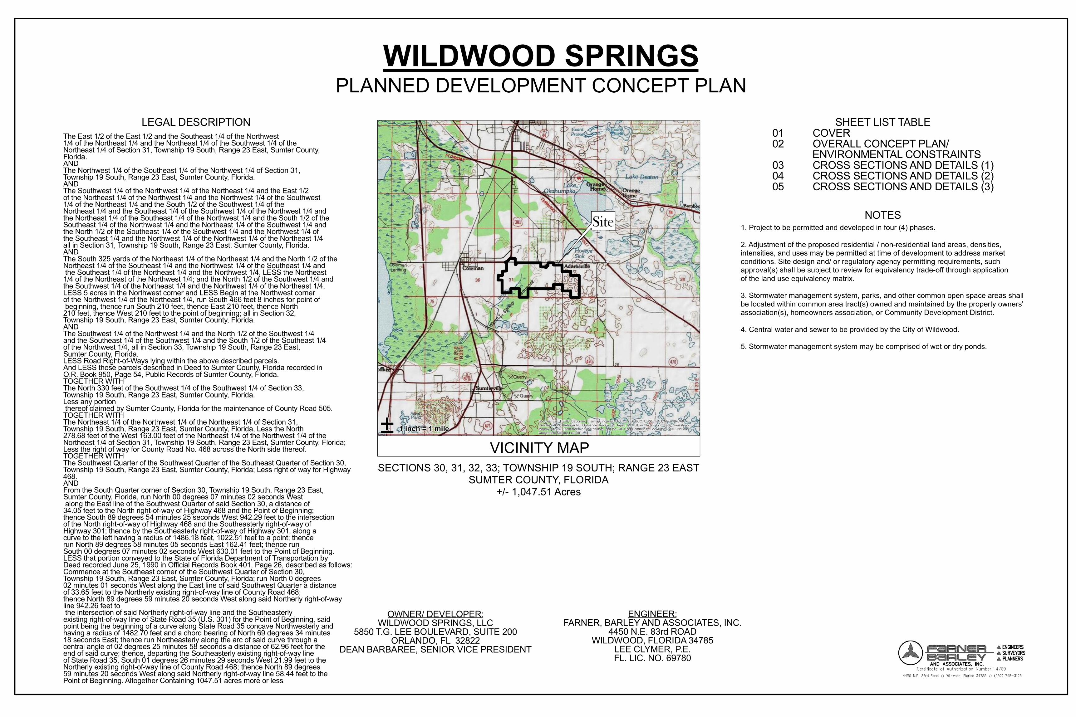
Site
Sources: Esri, HERE, DeLorme, Intermap, increment P Corp., GEBCO, USGS, FAO, NPS, NRCAN,GeoBase, IGN, Kadaster NL, Ordnance Survey, Esri Japan, METI, Esri China (Hong Kong), swisstopo,MapmyIndia, © OpenStreetMap contributors, and the GIS User Community, Copyright:© 2013 NationalGeographic Society, i-cubed
PLANNED DEVELOPMENT CONCEPT PLANWILDWOOD SPRINGS
SECTIONS 30, 31, 32, 33; TOWNSHIP 19 SOUTH; RANGE 23 EASTSUMTER COUNTY, FLORIDA
+/- 1,047.51 Acres
± 1 inch = 1 mile
VICINITY MAP
LEGAL DESCRIPTIONThe East 1/2 of the East 1/2 and the Southeast 1/4 of the Northwest 1/4 of the Northeast 1/4 and the Northeast 1/4 of the Southwest 1/4 of the Northeast 1/4 of Section 31, Township 19 South, Range 23 East, Sumter County, Florida.ANDThe Northwest 1/4 of the Southeast 1/4 of the Northwest 1/4 of Section 31, Township 19 South, Range 23 East, Sumter County, Florida.ANDThe Southwest 1/4 of the Northwest 1/4 of the Northeast 1/4 and the East 1/2 of the Northeast 1/4 of the Northwest 1/4 and the Northwest 1/4 of the Southwest 1/4 of the Northeast 1/4 and the South 1/2 of the Southwest 1/4 of the Northeast 1/4 and the Southeast 1/4 of the Southwest 1/4 of the Northwest 1/4 and the Northeast 1/4 of the Southeast 1/4 of the Northwest 1/4 and the South 1/2 of the Southeast 1/4 of the Northwest 1/4 and the Northeast 1/4 of the Southwest 1/4 and the North 1/2 of the Southeast 1/4 of the Southwest 1/4 and the Northwest 1/4 of the Southeast 1/4 and the Northwest 1/4 of the Northwest 1/4 of the Northeast 1/4 all in Section 31, Township 19 South, Range 23 East, Sumter County, Florida.ANDThe South 325 yards of the Northeast 1/4 of the Northeast 1/4 and the North 1/2 of the Northeast 1/4 of the Southeast 1/4 and the Northwest 1/4 of the Southeast 1/4 and the Southeast 1/4 of the Northeast 1/4 and the Northwest 1/4, LESS the Northeast 1/4 of the Northeast of the Northwest 1/4; and the North 1/2 of the Southwest 1/4 and the Southwest 1/4 of the Northeast 1/4 and the Northwest 1/4 of the Northeast 1/4, LESS 5 acres in the Northwest corner and LESS Begin at the Northwest corner of the Northwest 1/4 of the Northeast 1/4, run South 466 feet 8 inches for point of beginning, thence run South 210 feet, thence East 210 feet, thence North 210 feet, thence West 210 feet to the point of beginning; all in Section 32, Township 19 South, Range 23 East, Sumter County, Florida.ANDThe Southwest 1/4 of the Northwest 1/4 and the North 1/2 of the Southwest 1/4 and the Southeast 1/4 of the Southwest 1/4 and the South 1/2 of the Southeast 1/4 of the Northwest 1/4, all in Section 33, Township 19 South, Range 23 East, Sumter County, Florida.LESS Road Right-of-Ways lying within the above described parcels.And LESS those parcels described in Deed to Sumter County, Florida recorded in O.R. Book 950, Page 54, Public Records of Sumter County, Florida.TOGETHER WITHThe North 330 feet of the Southwest 1/4 of the Southwest 1/4 of Section 33, Township 19 South, Range 23 East, Sumter County, Florida.Less any portion thereof claimed by Sumter County, Florida for the maintenance of County Road 505.TOGETHER WITHThe Northeast 1/4 of the Northwest 1/4 of the Northeast 1/4 of Section 31, Township 19 South, Range 23 East, Sumter County, Florida, Less the North 278.68 feet of the West 163.00 feet of the Northeast 1/4 of the Northwest 1/4 of the Northeast 1/4 of Section 31, Township 19 South, Range 23 East, Sumter County, Florida; Less the right of way for County Road No. 468 across the North side thereof.TOGETHER WITHThe Southwest Quarter of the Southwest Quarter of the Southeast Quarter of Section 30, Township 19 South, Range 23 East, Sumter County, Florida; Less right of way for Highway 468.ANDFrom the South Quarter corner of Section 30, Township 19 South, Range 23 East, Sumter County, Florida, run North 00 degrees 07 minutes 02 seconds West along the East line of the Southwest Quarter of said Section 30, a distance of 34.05 feet to the North right-of-way of Highway 468 and the Point of Beginning;thence South 89 degrees 54 minutes 25 seconds West 942.29 feet to the intersection of the North right-of-way of Highway 468 and the Southeasterly right-of-way of Highway 301; thence by the Southeasterly right-of-way of Highway 301, along a curve to the left having a radius of 1486.18 feet, 1022.51 feet to a point; thence run North 89 degrees 58 minutes 05 seconds East 162.41 feet; thence run South 00 degrees 07 minutes 02 seconds West 630.01 feet to the Point of Beginning.LESS that portion conveyed to the State of Florida Department of Transportation by Deed recorded June 25, 1990 in Official Records Book 401, Page 26, described as follows:Commence at the Southeast corner of the Southwest Quarter of Section 30, Township 19 South, Range 23 East, Sumter County, Florida; run North 0 degrees 02 minutes 01 seconds West along the East line of said Southwest Quarter a distance of 33.65 feet to the Northerly existing right-of-way line of County Road 468; thence North 89 degrees 59 minutes 20 seconds West along said Northerly right-of-way line 942.26 feet to the intersection of said Northerly right-of-way line and the Southeasterly existing right-of-way line of State Road 35 (U.S. 301) for the Point of Beginning, said point being the beginning of a curve along State Road 35 concave Northwesterly and having a radius of 1482.70 feet and a chord bearing of North 69 degrees 34 minutes 18 seconds East; thence run Northeasterly along the arc of said curve through acentral angle of 02 degrees 25 minutes 58 seconds a distance of 62.96 feet for the end of said curve; thence, departing the Southeasterly existing right-of-way line of State Road 35, South 01 degrees 26 minutes 29 seconds West 21.99 feet to the Northerly existing right-of-way line of County Road 468; thence North 89 degrees 59 minutes 20 seconds West along said Northerly right-of-way line 58.44 feet to thePoint of Beginning. Altogether Containing 1047.51 acres more or less
OWNER/ DEVELOPER:WILDWOOD SPRINGS, LLC
5850 T.G. LEE BOULEVARD, SUITE 200ORLANDO, FL 32822
DEAN BARBAREE, SENIOR VICE PRESIDENT
ENGINEER:FARNER, BARLEY AND ASSOCIATES, INC.
4450 N.E. 83rd ROADWILDWOOD, FLORIDA 34785
LEE CLYMER, P.E.FL. LIC. NO. 69780
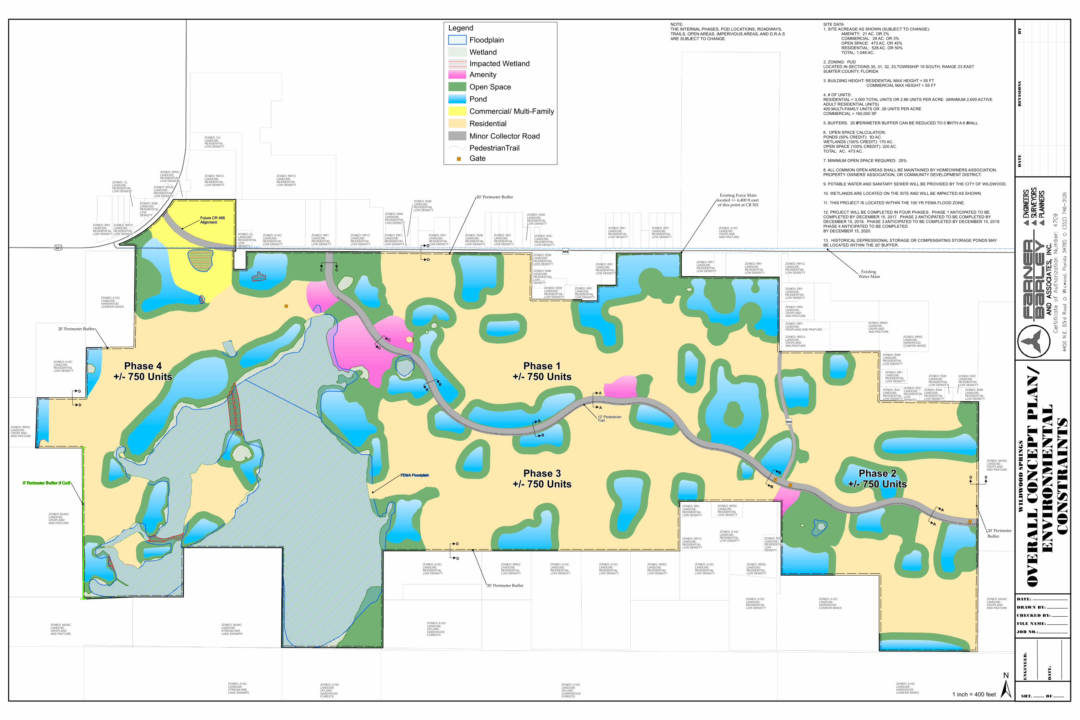
01 COVER02 OVERALL CONCEPT PLAN/ ENVIRONMENTAL CONSTRAINTS03 CROSS SECTIONS AND DETAILS (1)04 CROSS SECTIONS AND DETAILS (2)05 CROSS SECTIONS AND DETAILS (3)
SHEET LIST TABLE
1. Project to be permitted and developed in four (4) phases.2. Adjustment of the proposed residential / non-residential land areas, densities, intensities, and uses may be permitted at time of development to address market conditions. Site design and/ or regulatory agency permitting requirements, such approval(s) shall be subject to review for equivalency trade-off through application of the land use equivalency matrix. 3. Stormwater management system, parks, and other common open space areas shallbe located within common area tract(s) owned and maintained by the property owners' association(s), homeowners association, or Community Development District.4. Central water and sewer to be provided by the City of Wildwood. 5. Stormwater management system may be comprised of wet or dry ponds.
NOTES
SHT. OF
WIL
DWOO
D SP
RING
S
OVER
ALL
CONC
EPT
PLAN
/EN
VIRO
NMEN
TAL
CONS
TRAI
NTS
")468£¤301
Phase 4+/- 750 Units
Phase 1+/- 750 Units
Phase 3+/- 750 Units
Phase 2+/- 750 Units
ZONED: CLLANDU SE: R ESIDENTIAL LOW DENSITY
ZONED: A10CLANDU SE: R ESIDENTIAL LOW DENSITY
ZONED: R R 1LANDU SE: R ESIDENTIALLOW DENSITY
ZONED: R R 1LANDU SE: R ESIDENTIALLOW DENSITY
ZONED: R R 1LANDU SE: R ESIDENTIALLOW DENSITY
ZONED: R R 1CLANDU SE: R ESIDENTIALLOW DENSITY
ZONED: R R 1CLANDU SE: R ESIDENTIAL LOW DENSITY
ZONED: R 2MLANDU SE: R ESIDENTIALLOW DENSITY
ZONED: R 2MLANDU SE: R ESIDENTIALLOW DENSITY
ZONED: R 2MLANDU SE: R ESIDENTIALLOW DENSITY
ZONED: R 2MLANDU SE: R ESIDENTIALLOW DENSITY
ZONED: R 2MLANDU SE: R ESIDENTIALLOW DENSITY
ZONED: R 4MLANDU SE: R ESIDENTIALLOW DENSITY
ZONED: R 4MLANDU SE: R ESIDENTIALLOW DENSITY
ZONED: R 4CLANDU SE: R ESIDENTIALLOW DENSITY
ZONED: R R 1CLANDU SE: R ESIDENTIAL LOW DENSITY
ZONED: R R 4CLANDU SE: R ESIDENTIAL LOW DENSITY
ZONED: R P U DLANDU SE: R ESIDENTIAL LOW DENSITY
ZONED: R 2MLANDU SE: R ESIDENTIAL LOW DENSITY
ZONED: CLLANDU SE: R ESIDENTIAL LOW DENSITY
ZONED: R R 1CLANDU SE: R ESIDENTIAL LOW DENSITY
ZONED: R R 1LANDU SE: R ESIDENTIALLOW DENSITY
ZONED: A10CLANDU SE: HAR DW OOD CONIFER MIX ED
ZONED: A10CLANDU SE: R ESIDENTIAL LOW DENSITY
ZONED: R R 5CLANDU SE: CR OP LAND AND P ASTU R E
ZONED: MU NCLANDU SE: CR OP LAND AND P ASTU R E
ZONED: MU NCLANDU SE: STR EAM AND LAKE SW AMP S
ZONED: A10CLANDU SE: STR EAM AND LAKE SW AMP S
ZONED: A10CLANDU SE: U P LANDHAR DW OODFOR ESTS
ZONED: A10CLANDU SE: U P LANDHAR DW OODFOR ESTS
ZONED: A10CLANDU SE: R ESIDENTIALLOW DENSITY
ZONED: R R 5CLANDU SE: R ESIDENTIALLOW DENSITY
ZONED: A10CLANDU SE: R ESIDENTIALLOW DENSITY
ZONED: A10CLANDU SE: R ESIDENTIALLOW DENSITY
ZONED: R R 5CLANDU SE: R ESIDENTIALLOW DENSITY
ZONED: R R 5CLANDU SE: R ESIDENTIALLOW DENSITY
ZONED: R R 5CLANDU SE: R ESIDENTIALLOW DENSITY
ZONED: R R 1LANDU SE: R ESIDENTIALLOW DENSITY
ZONED: R R 1CLANDU SE: R ESIDENTIALLOW DENSITY
ZONED: R 2MLANDU SE: R ESIDENTIALLOW DENSITY
ZONED: A10CLANDU SE: HAR DW OODCONIFER MIX ED
ZONED: A10CLANDU SE: HAR DW OODCONIFER MIX ED
ZONED: MU NCLANDU SE: CR OP LANDAND P ASTU R E
ZONED: R 4MLANDU SE: R ESIDENTIAL LOW DENSITY
ZONED: R 4MLANDU SE: R ESIDENTIAL LOW DENSITY
ZONED: R 4MLANDU SE: R ESIDENTIAL LOW DENSITY
ZONED: R 2MLANDU SE: R ESIDENTIAL LOW DENSITY
ZONED: R 2CLANDU SE: R ESIDENTIAL LOW DENSITY
ZONED: R 4CLANDU SE: R ESIDENTIAL LOW DENSITY
ZONED: R R 1LANDU SE: R ESIDENTIAL LOW DENSITY
ZONED: R R 5CLANDU SE: HAR DW OODCONIFER MIX ED
ZONED: R R 2.5LANDU SE: CR OP LANDAND P ASTU R E
ZONED: R R 5LANDU SE: CR OP LANDAND P ASTU R E
ZONED: R R 1LANDU SE: CR OP LAND AND P ASTU R E
ZONED: R R 1LANDU SE: R ESIDENTIAL LOW DENSITY
ZONED: R R 1LANDU SE: R ESIDENTIAL LOW DENSITY
ZONED: R R 1LANDU SE: R ESIDENTIAL LOW DENSITY
ZONED: R R 1CLANDU SE: R ESIDENTIAL LOW DENSITY
ZONED: A10CLANDU SE: CR OP LANDAND P ASTU R E
ZONED: R R 1LANDU SE: R ESIDENTIAL LOW DENSITY
ZONED: R R 1LANDU SE: R ESIDENTIAL LOW DENSITY
ZONED: R R 1LANDU SE: R ESIDENTIAL LOW DENSITY
ZONED: R R 5CLANDU SE: CR OP LANDAND P ASTU R E
ZONED: A10CLANDU SE: R ESIDENTIALLOW DENSITY
ZONED: A10CLANDU SE: R ESIDENTIALLOW DENSITY
ZONED: A10CLANDU SE: R ESIDENTIALLOW DENSITY
ZONED: MU NCLANDU SE: CR OP LAND AND P ASTU R E
ZONED: CHLANDU SE: R ESIDENTIAL LOW DENSITY
ZONED: R R 1LANDU SE: R ESIDENTIALLOW DENSITY
ZONED: R R 1LANDU SE: R ESIDENTIAL LOW DENSITY
ZONED: R 4CLANDU SE: R ESIDENTIAL LOW DENSITY
ZONED: MU NCLANDU SE: CR OP LANDAND P ASTU R E
ZONED: A10CLANDU SE: U P LANDCONIFER OU SFOR ESTS
FEMA Floodplain
12' P edestrian Trail ")505B
B
D D
CC
D
D
D
D
Future CR 468Alignment
20' Perimeter Buffer
20' Perimeter Buffer
20' Perimeter Buffer
20' Perimeter Buffer
Existing Water Main
Existing Force Mainlocated +/- 6,400 ft east of this point at CR 501
BB
D
D
A
A
B
B
A
A
"6
"6
"6
"6
0' Perimeter Buffer if Golf
CC
DATE:DRAWN BY:CHECKED BY:FILE NAME:JOB NO.:
BYRE
VISI
ONS
DATE
ENGI
NEER
:
DATE
:
±1 inch = 400 feet
SITE DATA1. SITE ACR EAGE AS SHOW N (SU BJECT TO CHANGE): AMENITY: 21 AC. OR 2% COMMER CIAL: 26 AC. OR 3% OP EN SP ACE: 473 AC. OR 45% R ESIDENTIAL: 528 AC. OR 50% TOTAL: 1,048 AC.2. ZONING: P U DLOCATED IN SECTIONS 30, 31, 32, 33,TOW NSHIP 19 SOU TH, R ANGE 23 EASTSU MTER COU NTY, FLOR IDA3. BU ILDING HEIGHT: R ESIDENTIAL MAX HEIGHT = 55 FT COMMER CIAL MAX HEIGHT = 55 FT4. # OF U NITS: R ESIDENTIAL = 3,000 TOTAL U NITS OR 2.86 U NITS P ER ACR E (MINIMU M 2,600 ACTIV E ADU LT R ESIDENTIAL U NITS) 400 MU LTI-FAMILY U NITS OR .38 U NITS P ER ACR ECOMMER CIAL = 160,000 SF5. BU FFER S: 20’ P ER IMETER BU FFER CAN BE R EDU CED TO 0’ W ITH A 6’ W ALL6. OP EN SP ACE CALCU LATION:P ONDS (50% CR EDIT): 83 AC. W ETLANDS (100% CR EDIT): 170 AC. OP EN SP ACE (100% CR EDIT): 220 AC. TOTAL: AC. 473 AC.7. MINIMU M OP EN SP ACE R EQ U R ED: 25%8. ALL COMMON OP EN AR EAS SHALL BE MAINTAINED BY HOMEOW NER S ASSOCIATION, P R OP ER TY OW NER S' ASSOCIATION, OR COMMU NITY DEV ELOP MENT DISTR ICT.9. P OTABLE W ATER AND SANITAR Y SEW ER W ILL BE P R OV IDED BY THE CITY OF W ILDW OOD.10. W ETLANDS AR E LOCATED ON THE SITE AND W ILL BE IMP ACTED AS SHOW N.11. THIS P R OJECT IS LOCATED W ITHIN THE 100 YR FEMA FLOOD ZONE.12. P R OJECT W ILL BE COMP LETED IN FOU R P HASES. P HASE 1 ANTICIP ATED TO BE COMP LETED BY DECEMBER 15, 2017. P HASE 2 ANTICIP ATED TO BE COMP LETED BY DECEMBER 15, 2018. P HASE 3 ANTICIP ATED TO BE COMP LETED BY DECEMBER 15, 2019. P HASE 4 ANTICIP ATED TO BE COMP LETEDBY DECEMBER 15, 2020.13. HISTOR ICAL DEP R ESSIONAL STOR AGE OR COMP ENSATING STOR AGE P ONDS MAY BE LOCATED W ITHIN THE 20' BU FFER .
NOTE:THE INTER NAL P HASES, P OD LOCATIONS, R OADW AYS,TR AILS, OP EN AR EAS, IMP ER V IOU S AR EAS, AND D.R .A.S AR E SU BJECT TO CHANGE.
Legend
W etland
AmenityOpen SpaceP ondCommercial/ Multi-FamilyR esidentialMinor Collector R oadP edestrianTrail
Impacted W etland
Floodplain
"6 Gate