Embed Size (px)
Citation preview
YUKONWILDLIFE VIEWING GUIDE
Knowing where and how to look
ALONG MAJOR HIGHWAYS
V I E W I N GW I L D L I F E
M
5
Highway - paved
International Border
Unpaved Road
Interprovincial Border
Unincorporated
Community
Campground
Recreation Site
Secondary Road
9
11
1
1
2
2
4
4
10
Viewing site (specific)
Viewing site (general)
Conservation area
Legend to all Maps
Interpreted site
Ferry Crossing
6
6
1
4
Highway - gravel4
783
Teslin R
Whi
te
Rive
r
Liard River
Kluane Lake
Gulf of Alaska
(Pacific Ocean)
Porcupine River
Peel R
iver
Pelly River
Yukon River
TatshenshiniRiver
BeaufortSea
(Arctic Ocean)
Dawson
WHITEHORSE
Teslin
Haines Junction
Destruction Bay
Beaver CreekPelly Crossing
Mayo
Keno
Old Crow
Carmacks
Stewart Crossing
Carcross
Faro
Ross River
Watson Lake
Burwash Landing
Ala
ska
B.C.
Northwest Territories
Macke nzie R iver
YUKON HIGHWAYS
Alaska Highway South & North Klondike Highways Haines Road Robert Campbell Highway Dempster Highway South & North Canol Roads Atlin Road Tagish Road Top of the World Highway Nahanni Range Road Silver Trail
1
2
3
4
5
6
7
8
9
10
11
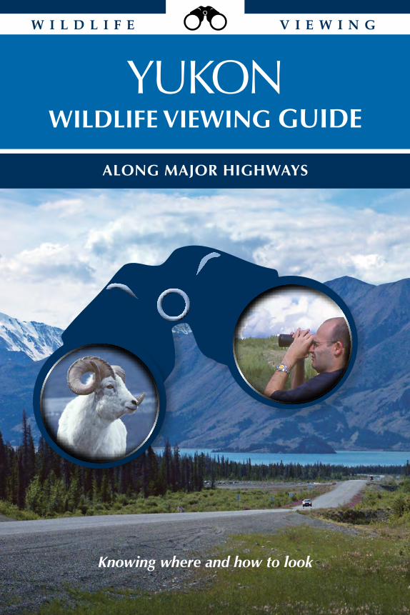
NATIONAL PARKSA Ivvavik National Park C Kluane National Park & ReserveB Vuntut National Park TERRITORIAL PARKSD Herschel Island - Qikiqtaruk H Asi KeyiE Tombstone I Coal River SpringsF Agay Mene J Ni’iinlii Njik (Fishing Branch)G awasuK HABITAT PROTECTION AREASK Ddhaw Ghro P Tagish NarrowsL Tsâwnjik Chu (Nordenskiold) Q Devil’s ElbowM Łútsäw Wetland R Pickhandle LakesN Horseshoe Slough S Ta’Tla MunO Lewes Marsh T Old Crow Flats
NATIONAL WILDLIFE AREASU Nisutlin Delta
A
B
T
J
E
H
C
G
KN
FU
I
S
Q
F
D
L
OP
R
V
YUKONWILDLIFE VIEWING GUIDE
ALONG MAJOR HIGHWAYS
Tintina Trench
Shakwak Trench
Shakwak Trench
YUKONWILDLIFE VIEWING GUIDE
ALONG MAJOR HIGHWAYS
Unless otherwise credited, all photographs © B. Bennett and all maps by R. Mulder.
Cover photo: Alaska Highway with Kluane Lake and Tachäl Dhäl in the background (Peter Long)
Aussi disponible en français comme «Guide d’observation de la faune et de la flore du Yukon».
Diese Broschüre ist als auch auf Deutsch erhältlich.
©2016 (12th revised edition); first printed 1995
How to use this guide _______________________________________________ page 2
Tips to wildlife viewing: How to look ___________________________________ page 3
Etiquette ___________________________________________________________ page 3
Precautions _________________________________________________________ page 4
Wildlife: What to look for _____________________________________________ page 5
Habitat: Where to look ______________________________________________ page 11
Outdoor recreation _________________________________________________ page 16
Sources of information ______________________________________________ page 61
Index: Species with locations _________________________________________ page 63
Index: Wildlife viewing sites _________________________________________ page 67
Contacts __________________________________________________ inside back cover
Alaska Highway Highway #1 _______________________________ page 18
South Klondike Highway Highway #2 _______________________________ page 32
North Klondike Highway Highway #2 _______________________________ page 34
Haines Road Highway #3 _______________________________ page 40
Robert Campbell Highway Highway #4 _______________________________ page 42
Dempster Highway Highway #5 _______________________________ page 47
South Canol Road Highway #6 _______________________________ page 54
Atlin Road Highway #7 _______________________________ page 56
Tagish Road Highway #8 _______________________________ page 57
Top of the World Highway Highway #9 _______________________________ page 58
Silver Trail Highway #11 ______________________________ page 59
CAPITAL LETTERS AND COMMON NAMES: In this guide, the common names of animals begin with capital letters to allow the reader to distinguish between species. For example, a Black Bear is a species of bear, not necessarily a bear that is black.
Yukon Wildlife Viewing Guide2
How to use this guide
This guide is organized to help you find the animal you are looking for and highlight key areas for wildlife viewing. Start with the alphabetical list of animals commonly found or sought after in Yukon (p.5). After this list, the guide describes seven key habitats found around the territory. You increase your chances of seeing your animal when you know which habitat to look for.
The remainder of the guide is organized by highway, then by numbered viewing sites along each highway with the kilometre (and mileage) posting for each site. Each site includes a description of its trails or routes, the level of difficulty, length and completion time, whether self-guided information is available, and the dominant habitat types found at the site. Because some animals can be found in many locations, you might not always find a reference to all the animals that could be present in a given viewing area.
Whether you’re looking for wildlife, planning a short hike or canoe, or simply looking for more information about Yukon’s environment, you will find this guide a helpful source of information.
Free brochures can be downloaded from Environment Yukon (www.wildlifeviewing.gov.yk.ca), picked up at many government offices, or sent by mail (contact the Wildlife Viewing office).
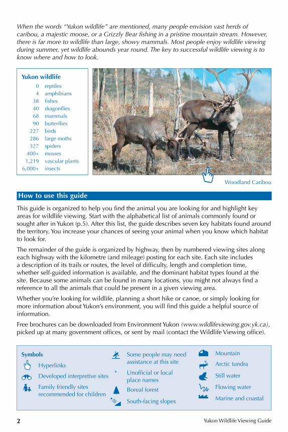
When the words “Yukon wildlife” are mentioned, many people envision vast herds of caribou, a majestic moose, or a Grizzly Bear fishing in a pristine mountain stream. However, there is far more to wildlife than large, showy mammals. Most people enjoy wildlife viewing during summer, yet wildlife abounds year round. The key to successful wildlife viewing is to know where and how to look.
Woodland Caribou
Yukon wildlife 0 reptiles 4 amphibians 38 fishes 40 dragonflies 68 mammals 90 butterflies 227 birds 286 large moths 327 spiders 400+ mosses 1,219 vascular plants 6,000+ insects
Symbols
Hyperlinks
Developed interpretive sites
Family friendly sites recommended for children
Some people may need assistance at this site
* Unofficial or local place names
Boreal forest
South-facing slopes
Mountain
Arctic tundra
Still water
Flowing water
Marine and coastal
Yukon Wildlife Viewing Guide
3
Tips to wildlife viewing: How to look
Appreciating wildlife and maintaining biological diversity are the goals of wildlife viewing. By visiting parks and protected areas, you will improve your chances of seeing wildlife. Leaving the busy highway corridor is often the best way to see wildlife and to appreciate it in its proper habitat. There are three general tips that you can use to improve your chances of seeing wildlife.
• Take your time and be quiet. Plan on making many stops when you are travelling. Slowly scan the landscape for movement. Animals that went into hiding may come out again when all is quiet.
• Animals tend to be more active in early morning and evening. Take a short walk before breakfast or after dinner. You may be pleasantly surprised at what you find. Remember, in summer, the arctic evening lasts all night.
• Use binoculars, spotting scopes and telephoto lenses to zoom in on the animals without scaring them away or endangering yourself.
Etiquette
Wildlife + distance = safety for Wildlife and you
• Pets should never be allowed to run at large. It is illegal to let pets chase or molest wildlife.
• Carry your food in sealed containers and pack out your garbage. Bears are attracted to unusual smells. Once accustomed to humans as a source of food, bears may become dangerous and may have to be destroyed. Remember, a fed bear is a dead bear.
• Arctic flora is delicate and sensitive. Use established trails and boardwalks to minimize disturbance.
• You may find what appears to be an “orphaned” bird or mammal. Do not pick it up. The parents are most certainly nearby, waiting for you to move away before coming back to retrieve their offspring.
• A bird that displays any “odd” behaviour or that calls and flies over your head is likely a parent requesting that you move on, carefully. Many birds nest on the ground and are vulnerable to trampling. Wandering visitors can flush birds from their nests, leaving eggs or young vulnerable to predators.
• Don’t let anyone harass wildlife. Report illegal hunting, trapping, fishing or polluting to the Turn in Poachers/Polluters (TIP Line) hotline at 1-800-661-0525.
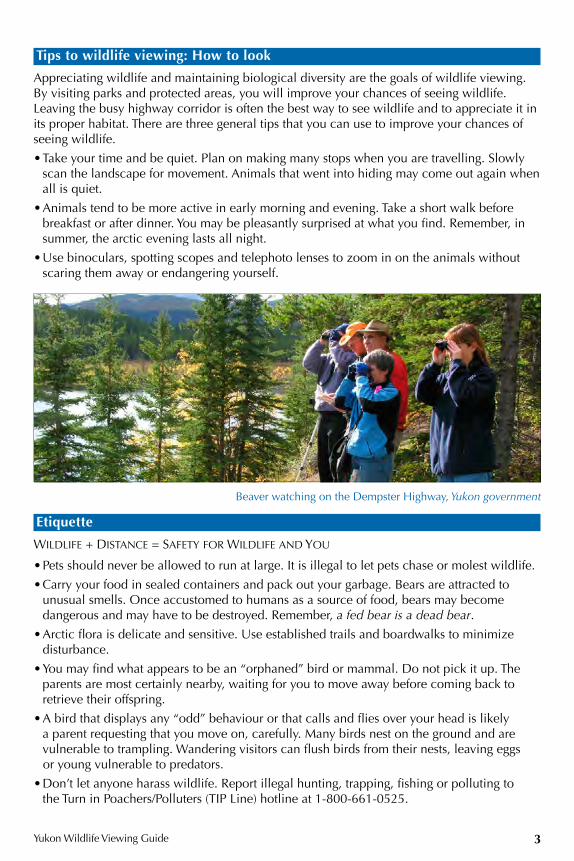
Beaver watching on the Dempster Highway, Yukon government
Mountain
Arctic tundra
Still water
Flowing water
Marine and coastal
Yukon Wildlife Viewing Guide4
Precautions
• Safety comes first. If you are the driver, realize that your first responsibility is safety. If there is traffic behind you, keep your eyes on the road and don’t stop. Recognize that your passengers will get a quick look, but that you may not. If there is no traffic, slow down and pull over where it is safe to do so.
• Co-existing with bears. Before you go, learn about bears and their habits. This will improve your chances of seeing them while respecting their space and ensuring your safety and theirs. For useful resources, see page 62.
• Feeding wild animals is never a good idea. Wild animals need natural foods to remain healthy. Wild animals that are accustomed to human food often become nuisance animals and may be killed. Yukoners try hard not to spoil wildlife. Please do your part and do not feed any wildlife species, for your safety and theirs.
• Fire is an important natural part of the boreal forest; however, fire frequency is increasing due to careless campfires. Please be careful. Make sure that your campfires are completely out before leaving your site.
• Overhanging vegetation on riverbanks, large standing dead trees, or trees with nests or nestholes are all important to wildlife. It is illegal to disturb a nest. Please respect the land and the creatures on it.
• Whether you are canoeing, kayaking, hiking or camping, a few precautions will ensure your comfort and safety. Bring some warm clothes, as the weather in Yukon can be unpredictable. Wear appropriate footwear for the area in which you plan to walk. If you are travelling unmarked trails or routes, carry a compass and map of the area. Pack all the food you will need. While it is enjoyable to add wild blueberries to breakfast cereals, do not plan to “live off the land.”
• To best prepare yourself for travelling safely in Yukon’s backcountry, pick up a free copy of Into the Yukon Wilderness (available at visitor information centres and from www.env.gov.yk.ca).
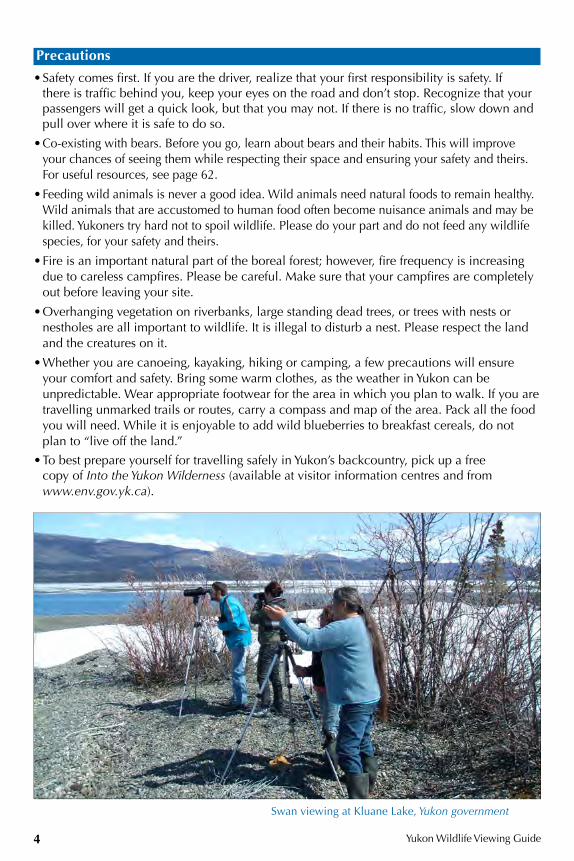
Swan viewing at Kluane Lake, Yukon government
Yukon Wildlife Viewing Guide
5
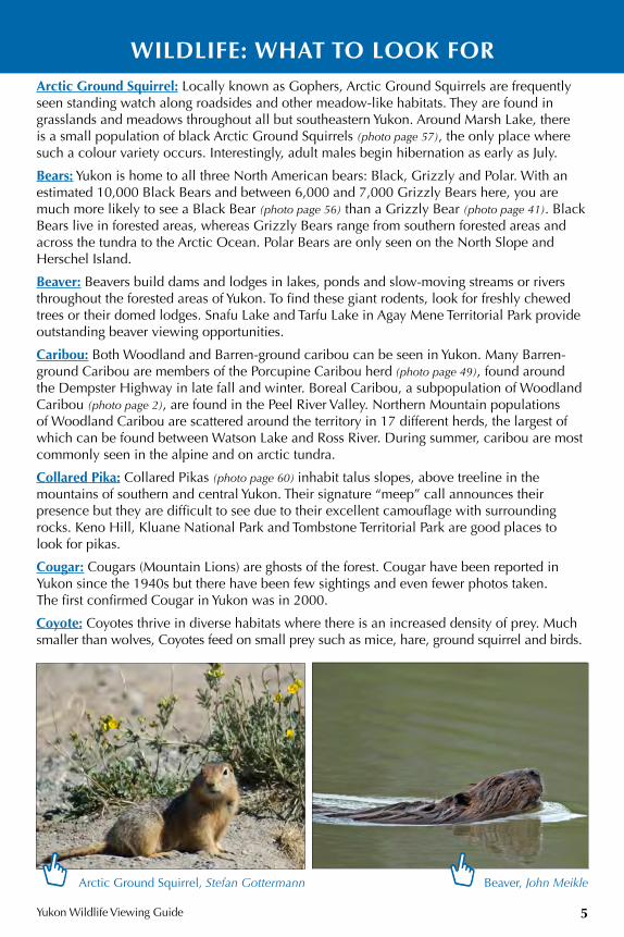
WILDLIFE: WHAT TO LOOK FOR Arctic Ground Squirrel: Locally known as Gophers, Arctic Ground Squirrels are frequently seen standing watch along roadsides and other meadow-like habitats. They are found in grasslands and meadows throughout all but southeastern Yukon. Around Marsh Lake, there is a small population of black Arctic Ground Squirrels (photo page 57), the only place where such a colour variety occurs. Interestingly, adult males begin hibernation as early as July.
Bears: Yukon is home to all three North American bears: Black, Grizzly and Polar. With an estimated 10,000 Black Bears and between 6,000 and 7,000 Grizzly Bears here, you are much more likely to see a Black Bear (photo page 56) than a Grizzly Bear (photo page 41). Black Bears live in forested areas, whereas Grizzly Bears range from southern forested areas and across the tundra to the Arctic Ocean. Polar Bears are only seen on the North Slope and Herschel Island.
Beaver: Beavers build dams and lodges in lakes, ponds and slow-moving streams or rivers throughout the forested areas of Yukon. To find these giant rodents, look for freshly chewed trees or their domed lodges. Snafu Lake and Tarfu Lake in Agay Mene Territorial Park provide outstanding beaver viewing opportunities.
Caribou: Both Woodland and Barren-ground caribou can be seen in Yukon. Many Barren-ground Caribou are members of the Porcupine Caribou herd (photo page 49), found around the Dempster Highway in late fall and winter. Boreal Caribou, a subpopulation of Woodland Caribou (photo page 2), are found in the Peel River Valley. Northern Mountain populations of Woodland Caribou are scattered around the territory in 17 different herds, the largest of which can be found between Watson Lake and Ross River. During summer, caribou are most commonly seen in the alpine and on arctic tundra.
Collared Pika: Collared Pikas (photo page 60) inhabit talus slopes, above treeline in the mountains of southern and central Yukon. Their signature “meep” call announces their presence but they are difficult to see due to their excellent camouflage with surrounding rocks. Keno Hill, Kluane National Park and Tombstone Territorial Park are good places to look for pikas.
Cougar: Cougars (Mountain Lions) are ghosts of the forest. Cougar have been reported in Yukon since the 1940s but there have been few sightings and even fewer photos taken. The first confirmed Cougar in Yukon was in 2000.
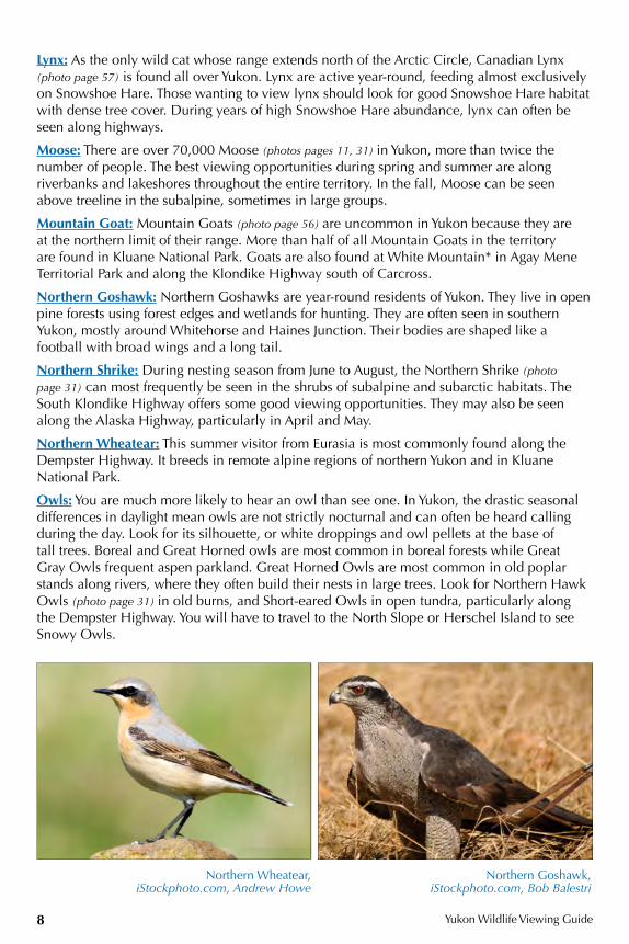
Coyote: Coyotes thrive in diverse habitats where there is an increased density of prey. Much smaller than wolves, Coyotes feed on small prey such as mice, hare, ground squirrel and birds.
Arctic Ground Squirrel, Stefan Gottermann Beaver, John Meikle
Yukon Wildlife Viewing Guide6
You have the best chance of seeing a Coyote in the evenings near a community because they are able to avoid wolves and are attracted to easy food sources in urban and cleared areas. Their numbers likely fluctuate with the rise and fall of Snowshoe Hare and vole populations.
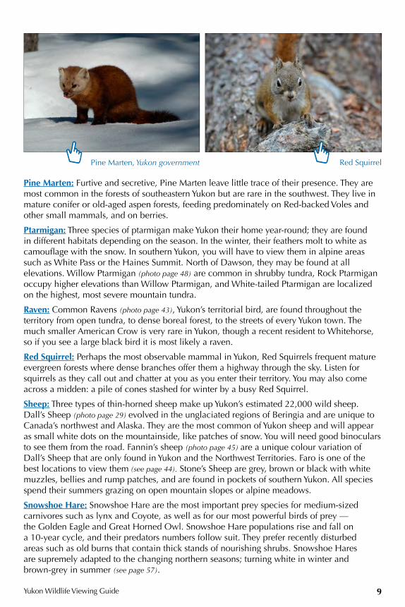
Crossbills: White-winged and Red crossbills occur in forested regions of Yukon, frequently in White Spruce forests. They are specialists at feeding on conifer cones, which they pry open with their uniquely shaped bills in search of seeds. The number of crossbills erupts following the cone crops — in years when cones are abundant so are the crossbills.
Deer: You are much more likely to see a Mule Deer than a White-tailed Deer in Yukon. Mule Deer, along with Coyotes and Cougars, are relatively recent immigrants to Yukon, having colonized Yukon in only the last 110 or so years. They prefer open grassy areas and often feed at dusk and dawn on the side of a road or in fields. Though found as far to the north as Dawson, most sightings are along the highways of southern Yukon.
Eagles: Bald and Golden eagles can be seen at almost any time of year, though there are few in mid-winter. Bald Eagles (photo page 18) can usually be found in lowland areas along rivers and lakes where they feed on fish and nest in tall trees, though they also frequent landfills. Golden Eagles are more commonly seen in alpine and arctic tundra areas where they feed on ground squirrels and nest almost exclusively on cliff faces.
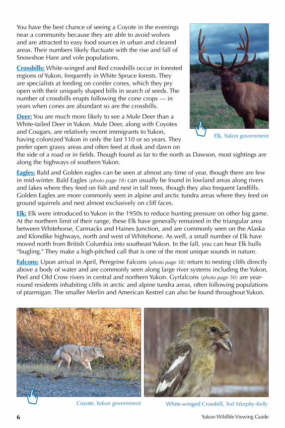
Elk: Elk were introduced to Yukon in the 1950s to reduce hunting pressure on other big game. At the northern limit of their range, these Elk have generally remained in the triangular area between Whitehorse, Carmacks and Haines Junction, and are commonly seen on the Alaska and Klondike highways, north and west of Whitehorse. As well, a small number of Elk have moved north from British Columbia into southeast Yukon. In the fall, you can hear Elk bulls “bugling.” They make a high-pitched call that is one of the most unique sounds in nature.
Falcons: Upon arrival in April, Peregrine Falcons (photo page 58) return to nesting cliffs directly above a body of water and are commonly seen along large river systems including the Yukon, Peel and Old Crow rivers in central and northern Yukon. Gyrfalcons (photo page 50) are year-round residents inhabiting cliffs in arctic and alpine tundra areas, often following populations of ptarmigan. The smaller Merlin and American Kestrel can also be found throughout Yukon.
Elk, Yukon government
Coyote, Yukon government White-winged Crossbill, Ted Murphy-Kelly
Yukon Wildlife Viewing Guide
7
Kestrels are often seen perched on posts or powerlines and Merlins nest mainly in northern Yukon but are seen frequently during migration.
Hawks: The most common hawks in Yukon are Red-tailed Hawks (photo page 41). They are difficult to identify because they have many colour variations but most common is the “Harlan’s” Red-tailed Hawk with a distinctly two-toned, underwing pattern. Rough-legged Hawks and Northern Harriers are commonly seen during migration but are rare in the summer except in marine and coastal areas. Swainson’s Hawks are also a rare sighting in southern Yukon in summer. To view hawks, find a scenic lookout with a great view and scan the open skies. Check out popular hawk hangouts such as windswept ridges and mountaintops, the tips of peninsulas and cliff tops next to water. (See also Northern Goshawk.)
Hoary Marmot: Hoary Marmots prefer south-facing mountainsides with large boulders and lush green tundra vegetation. They are not very common in Yukon, but if you are travelling on mountain highways, stop and listen for their loud, long and steady whistle to help direct you where to look. Keno Hill, Kluane National Park and Tombstone Territorial Park have healthy marmot populations.
Jaegers: Jaegers gather on the North Slope near the Beaufort Sea during the summer breeding season. Long-tailed Jaegers are commonly seen along the Dempster Highway in summer.
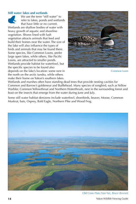
Loons: There are four species of loon in Yukon. During summer in southern Yukon, you can find the Common and Pacific loons on many different lakes. Red-throated (photo page 14) and Yellow-billed loons are only found north of the tree line in mid-summer, but commonly seen during migration in southern Yukon.
Mule Deer, Jake Paleczny
Rough-legged Hawk, Cameron Eckert Hoary Marmot, Yukon government
Long-tailed Jaeger, Yukon government
Yukon Wildlife Viewing Guide8
Lynx: As the only wild cat whose range extends north of the Arctic Circle, Canadian Lynx (photo page 57) is found all over Yukon. Lynx are active year-round, feeding almost exclusively on Snowshoe Hare. Those wanting to view lynx should look for good Snowshoe Hare habitat with dense tree cover. During years of high Snowshoe Hare abundance, lynx can often be seen along highways.
Moose: There are over 70,000 Moose (photos pages 11, 31) in Yukon, more than twice the number of people. The best viewing opportunities during spring and summer are along riverbanks and lakeshores throughout the entire territory. In the fall, Moose can be seen above treeline in the subalpine, sometimes in large groups.
Mountain Goat: Mountain Goats (photo page 56) are uncommon in Yukon because they are at the northern limit of their range. More than half of all Mountain Goats in the territory are found in Kluane National Park. Goats are also found at White Mountain* in Agay Mene Territorial Park and along the Klondike Highway south of Carcross.
Northern Goshawk: Northern Goshawks are year-round residents of Yukon. They live in open pine forests using forest edges and wetlands for hunting. They are often seen in southern Yukon, mostly around Whitehorse and Haines Junction. Their bodies are shaped like a football with broad wings and a long tail.
Northern Shrike: During nesting season from June to August, the Northern Shrike (photo page 31) can most frequently be seen in the shrubs of subalpine and subarctic habitats. The South Klondike Highway offers some good viewing opportunities. They may also be seen along the Alaska Highway, particularly in April and May.
Northern Wheatear: This summer visitor from Eurasia is most commonly found along the Dempster Highway. It breeds in remote alpine regions of northern Yukon and in Kluane National Park.
Owls: You are much more likely to hear an owl than see one. In Yukon, the drastic seasonal differences in daylight mean owls are not strictly nocturnal and can often be heard calling during the day. Look for its silhouette, or white droppings and owl pellets at the base of tall trees. Boreal and Great Horned owls are most common in boreal forests while Great Gray Owls frequent aspen parkland. Great Horned Owls are most common in old poplar stands along rivers, where they often build their nests in large trees. Look for Northern Hawk Owls (photo page 31) in old burns, and Short-eared Owls in open tundra, particularly along the Dempster Highway. You will have to travel to the North Slope or Herschel Island to see Snowy Owls.
Northern Wheatear, iStockphoto.com, Andrew Howe
Northern Goshawk, iStockphoto.com, Bob Balestri
Yukon Wildlife Viewing Guide
9
Pine Marten: Furtive and secretive, Pine Marten leave little trace of their presence. They are most common in the forests of southeastern Yukon but are rare in the southwest. They live in mature conifer or old-aged aspen forests, feeding predominately on Red-backed Voles and other small mammals, and on berries.
Ptarmigan: Three species of ptarmigan make Yukon their home year-round; they are found in different habitats depending on the season. In the winter, their feathers molt to white as camouflage with the snow. In southern Yukon, you will have to view them in alpine areas such as White Pass or the Haines Summit. North of Dawson, they may be found at all elevations. Willow Ptarmigan (photo page 48) are common in shrubby tundra, Rock Ptarmigan occupy higher elevations than Willow Ptarmigan, and White-tailed Ptarmigan are localized on the highest, most severe mountain tundra.
Raven: Common Ravens (photo page 43), Yukon’s territorial bird, are found throughout the territory from open tundra, to dense boreal forest, to the streets of every Yukon town. The much smaller American Crow is very rare in Yukon, though a recent resident to Whitehorse, so if you see a large black bird it is most likely a raven.
Red Squirrel: Perhaps the most observable mammal in Yukon, Red Squirrels frequent mature evergreen forests where dense branches offer them a highway through the sky. Listen for squirrels as they call out and chatter at you as you enter their territory. You may also come across a midden: a pile of cones stashed for winter by a busy Red Squirrel.
Sheep: Three types of thin-horned sheep make up Yukon’s estimated 22,000 wild sheep. Dall’s Sheep (photo page 29) evolved in the unglaciated regions of Beringia and are unique to Canada’s northwest and Alaska. They are the most common of Yukon sheep and will appear as small white dots on the mountainside, like patches of snow. You will need good binoculars to see them from the road. Fannin’s sheep (photo page 45) are a unique colour variation of Dall’s Sheep that are only found in Yukon and the Northwest Territories. Faro is one of the best locations to view them (see page 44). Stone’s Sheep are grey, brown or black with white muzzles, bellies and rump patches, and are found in pockets of southern Yukon. All species spend their summers grazing on open mountain slopes or alpine meadows.
Snowshoe Hare: Snowshoe Hare are the most important prey species for medium-sized carnivores such as lynx and Coyote, as well as for our most powerful birds of prey — the Golden Eagle and Great Horned Owl. Snowshoe Hare populations rise and fall on a 10-year cycle, and their predators numbers follow suit. They prefer recently disturbed areas such as old burns that contain thick stands of nourishing shrubs. Snowshoe Hares are supremely adapted to the changing northern seasons; turning white in winter and brown-grey in summer (see page 57).
Pine Marten, Yukon government Red Squirrel
Yukon Wildlife Viewing Guide10
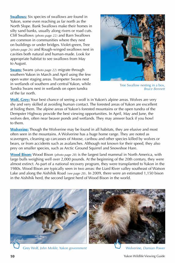
Swallows: Six species of swallows are found in Yukon, some even reaching as far north as the North Slope. Bank Swallows make their homes in silty sand banks, usually along rivers or road cuts. Cliff Swallows (photo page 22) and Barn Swallows are common in communities where they nest on buildings or under bridges. Violet-green, Tree (photo page 26) and Rough-winged swallows nest in cavities both natural and human-made. Look for appropriate habitat to see swallows from May to August.
Swans: Swans (photo page 22) migrate through southern Yukon in March and April using the few open water staging areas. Trumpeter Swans nest in wetlands of southern and central Yukon, while Tundra Swans nest in wetlands on open tundra of the far north.
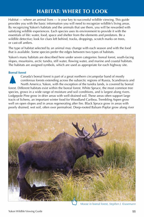
Wolf, Grey: Your best chance of seeing a wolf is in Yukon’s alpine areas. Wolves are very shy and very skilled at avoiding human contact. The forested areas of Yukon are excellent at hiding them. The alpine areas of Yukon’s forested mountains or the open tundra of the Dempster Highway provide the best viewing opportunities. In April, May and June, the wolves den, often near beaver ponds and wetlands. They may answer back if you howl to them.
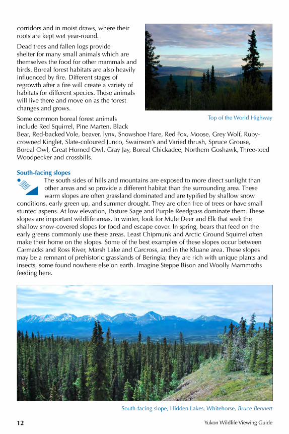
Wolverine: Though the Wolverine may be found in all habitats, they are elusive and most often seen in the mountains. A Wolverine has a huge home range. They are noted as scavengers, cleaning up carcasses of Moose, caribou and other species killed by wolves or bears, or from accidents such as avalanches. Although not known for their speed, they also prey on smaller species, such as Arctic Ground Squirrel and Snowshoe Hare.
Wood Bison: Wood Bison (photo page 28) is the largest land mammal in North America, with large bulls weighing well over 2,000 pounds. At the beginning of the 20th century, they were almost extinct. As part of a national recovery program, they were transplanted to Yukon in the 1980s. Wood Bison are typically seen in two areas: the Liard River valley southeast of Watson Lake and along the Aishihik Road (see page 28). In 2009, there were an estimated 1,150 bison in the Aishihik herd, the second largest herd of Wood Bison in the world.
Wolverine, Damian PowerGrey Wolf, John Meikle, Yukon government
Tree Swallow nesting in a box, Bruce Bennett
Yukon Wildlife Viewing Guide
11
HABITAT: WHERE TO LOOK Habitat — where an animal lives — is your key to successful wildlife viewing. This guide provides you with the basic information you will need to recognize wildlife’s living areas. By recognizing Yukon’s habitats and the animals that use them, you will be rewarded with satisfying wildlife experiences. Each species uses its environment to provide it with the essentials of life: water, food, space and shelter from the elements and predators. Be a wildlife detective; look for clues left behind, tracks, droppings, scratch marks on trees, or cast-off antlers.
The type of habitat selected by an animal may change with each season and with the food that is available. Some species prefer the edges between two types of habitats.
Yukon’s many habitats are described here under seven categories: boreal forest, south-facing slopes, mountains, arctic tundra, still water, flowing water, and marine and coastal habitats. The habitats are assigned symbols, which are used as appropriate for each highway site.
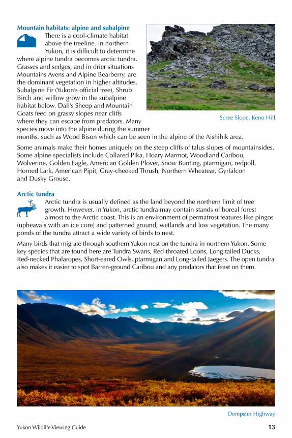
Boreal forestCanada’s boreal forest is part of a great northern circumpolar band of mostly coniferous forests extending across the subarctic regions of Russia, Scandinavia and North America. Yukon, with the exception of the tundra lands, is covered by boreal
forest. Different habitats exist within the boreal forest. White Spruce, the most common tree species, grows in a wide range of moisture and soil conditions, and is largest along rivers. Lodgepole Pine grow in drier areas with well-drained soil. These areas often support large tracts of lichens, an important winter food for Woodland Caribou. Trembling Aspen grow well on open slopes and in areas regenerating after fire. Black Spruce grow in areas with poorly drained, wet soil, often over permafrost. Deep-rooted Balsam Poplar grow along river
Moose in boreal forest, Stephen J. Krasemann
Yukon Wildlife Viewing Guide12
corridors and in moist draws, where their roots are kept wet year-round.
Dead trees and fallen logs provide shelter for many small animals which are themselves the food for other mammals and birds. Boreal forest habitats are also heavily influenced by fire. Different stages of regrowth after a fire will create a variety of habitats for different species. These animals will live there and move on as the forest changes and grows.
Some common boreal forest animals include Red Squirrel, Pine Marten, Black Bear, Red-backed Vole, beaver, lynx, Snowshoe Hare, Red Fox, Moose, Grey Wolf, Ruby-crowned Kinglet, Slate-coloured Junco, Swainson’s and Varied thrush, Spruce Grouse, Boreal Owl, Great Horned Owl, Gray Jay, Boreal Chickadee, Northern Goshawk, Three-toed Woodpecker and crossbills.
South-facing slopesThe south sides of hills and mountains are exposed to more direct sunlight than other areas and so provide a different habitat than the surrounding area. These warm slopes are often grassland dominated and are typified by shallow snow
conditions, early green up, and summer drought. They are often free of trees or have small stunted aspens. At low elevation, Pasture Sage and Purple Reedgrass dominate them. These slopes are important wildlife areas. In winter, look for Mule Deer and Elk that seek the shallow snow-covered slopes for food and escape cover. In spring, bears that feed on the early greens commonly use these areas. Least Chipmunk and Arctic Ground Squirrel often make their home on the slopes. Some of the best examples of these slopes occur between Carmacks and Ross River, Marsh Lake and Carcross, and in the Kluane area. These slopes may be a remnant of prehistoric grasslands of Beringia; they are rich with unique plants and insects, some found nowhere else on earth. Imagine Steppe Bison and Woolly Mammoths feeding here.
South-facing slope, Hidden Lakes, Whitehorse, Bruce Bennett
Top of the World Highway
Yukon Wildlife Viewing Guide 13
Mountain habitats: alpine and subalpineThere is a cool-climate habitat above the treeline. In northern Yukon, it is difficult to determine
where alpine tundra becomes arctic tundra. Grasses and sedges, and in drier situations Mountains Avens and Alpine Bearberry, are the dominant vegetation in higher altitudes. Subalpine Fir (Yukon’s official tree), Shrub Birch and willow grow in the subalpine habitat below. Dall’s Sheep and Mountain Goats feed on grassy slopes near cliffs where they can escape from predators. Many species move into the alpine during the summer months, such as Wood Bison which can be seen in the alpine of the Aishihik area.
Some animals make their homes uniquely on the steep cliffs of talus slopes of mountainsides. Some alpine specialists include Collared Pika, Hoary Marmot, Woodland Caribou, Wolverine, Golden Eagle, American Golden Plover, Snow Bunting, ptarmigan, redpoll, Horned Lark, American Pipit, Gray-cheeked Thrush, Northern Wheatear, Gyrfalcon and Dusky Grouse.
Arctic tundraArctic tundra is usually defined as the land beyond the northern limit of tree growth. However, in Yukon, arctic tundra may contain stands of boreal forest almost to the Arctic coast. This is an environment of permafrost features like pingos
(upheavals with an ice core) and patterned ground, wetlands and low vegetation. The many ponds of the tundra attract a wide variety of birds to nest.
Many birds that migrate through southern Yukon nest on the tundra in northern Yukon. Some key species that are found here are Tundra Swans, Red-throated Loons, Long-tailed Ducks, Red-necked Phalaropes, Short-eared Owls, ptarmigan and Long-tailed Jaegers. The open tundra also makes it easier to spot Barren-ground Caribou and any predators that feast on them.
Scree Slope, Keno Hill
Dempster Highway
Yukon Wildlife Viewing Guide14
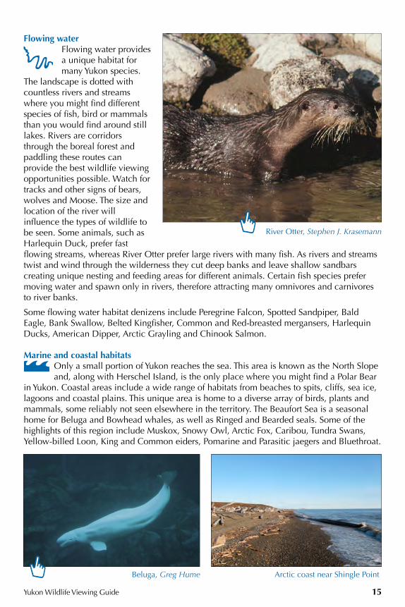
Still water: lakes and wetlandsWe use the term “still water” to refer to lakes, ponds and wetlands that have little or no current.
Wetlands are shallow bodies of water with heavy growth of aquatic and shoreline vegetation. Shores lined with lush vegetation attracts animals that feed and build their homes near the water. The size of the lake will also influence the types of birds and animals that may be found there. Some species, like Common Loons, prefer large open lakes, while others, like Pacific Loons, are attracted to smaller ponds. Wetlands provide habitat for waterfowl, but the specific species to be found also depends on the lake’s location: some nest in the north on the arctic tundra, while others make their home on Yukon’s southern lakes. Wetlands and marshes often have standing dead trees that provide nesting cavities for Common and Barrow’s goldeneye and Bufflehead. Many species of songbird, such as Yellow Warbler, Common Yellowthroat and Northern Waterthrush, nest in the surrounding forest and feast on the insects that emerge from the water during June and July.
Some still water habitat denizens include waterfowl, shorebirds, beaver, Moose, Common Muskrat, bats, Osprey, Bald Eagle, Northern Pike and Wood Frog.
Common Loon
Old Crow Flats (Van Tat), Bruce Bennett
Yukon Wildlife Viewing Guide 15
Flowing waterFlowing water provides a unique habitat for many Yukon species.
The landscape is dotted with countless rivers and streams where you might find different species of fish, bird or mammals than you would find around still lakes. Rivers are corridors through the boreal forest and paddling these routes can provide the best wildlife viewing opportunities possible. Watch for tracks and other signs of bears, wolves and Moose. The size and location of the river will influence the types of wildlife to be seen. Some animals, such as Harlequin Duck, prefer fast flowing streams, whereas River Otter prefer large rivers with many fish. As rivers and streams twist and wind through the wilderness they cut deep banks and leave shallow sandbars creating unique nesting and feeding areas for different animals. Certain fish species prefer moving water and spawn only in rivers, therefore attracting many omnivores and carnivores to river banks.
Some flowing water habitat denizens include Peregrine Falcon, Spotted Sandpiper, Bald Eagle, Bank Swallow, Belted Kingfisher, Common and Red-breasted mergansers, Harlequin Ducks, American Dipper, Arctic Grayling and Chinook Salmon.
Marine and coastal habitatsOnly a small portion of Yukon reaches the sea. This area is known as the North Slope and, along with Herschel Island, is the only place where you might find a Polar Bear
in Yukon. Coastal areas include a wide range of habitats from beaches to spits, cliffs, sea ice, lagoons and coastal plains. This unique area is home to a diverse array of birds, plants and mammals, some reliably not seen elsewhere in the territory. The Beaufort Sea is a seasonal home for Beluga and Bowhead whales, as well as Ringed and Bearded seals. Some of the highlights of this region include Muskox, Snowy Owl, Arctic Fox, Caribou, Tundra Swans, Yellow-billed Loon, King and Common eiders, Pomarine and Parasitic jaegers and Bluethroat.
River Otter, Stephen J. Krasemann
Arctic coast near Shingle Point Beluga, Greg Hume
Yukon Wildlife Viewing Guide16
Outdoor recreation
Campgrounds, recreation sites, rest areas, picnic sites, hiking trails, lakes and rivers all offer excellent wildlife viewing opportunities.
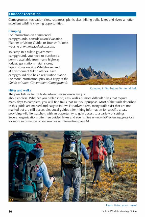
CampingFor information on commercial campgrounds, consult Yukon’s Vacation Planner or Visitor Guide, or Tourism Yukon’s website at www.travelyukon.com.
To camp in a Yukon government campground, you need to purchase a permit, available from many highway lodges, gas stations, retail stores, liquor stores outside Whitehorse, and at Environment Yukon offices. Each campground also has a registration station. For more information, pick up a copy of the Guide to Yukon Government Campgrounds.
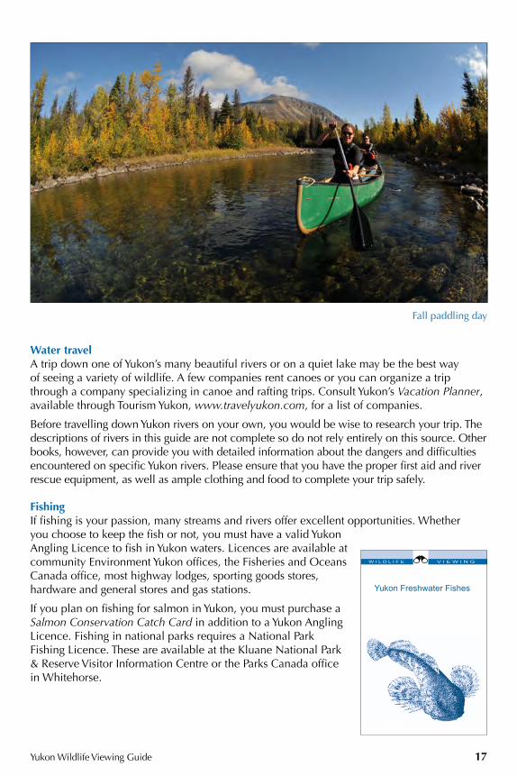
Hikes and walksThe possibilities for trailside adventures in Yukon are just about endless. Whether you prefer short, easy walks or more difficult hikes that require many days to complete, you will find trails that suit your purpose. Most of the trails described in this guide are marked and easy to follow. For adventurers, many trails exist that are not marked but are still accessible. Local guides offer hiking information for specific areas, providing wildlife watchers with an opportunity to gain access to a variety of settings. Several organizations offer free guided hikes and events. See www.wildlifeviewing.gov.yk.ca for more information or see sources of information page 61.
Camping in Tombstone Territorial Park
Hikers, Yukon government
Yukon Wildlife Viewing Guide 17
Water travelA trip down one of Yukon’s many beautiful rivers or on a quiet lake may be the best way of seeing a variety of wildlife. A few companies rent canoes or you can organize a trip through a company specializing in canoe and rafting trips. Consult Yukon’s Vacation Planner, available through Tourism Yukon, www.travelyukon.com, for a list of companies.
Before travelling down Yukon rivers on your own, you would be wise to research your trip. The descriptions of rivers in this guide are not complete so do not rely entirely on this source. Other books, however, can provide you with detailed information about the dangers and difficulties encountered on specific Yukon rivers. Please ensure that you have the proper first aid and river rescue equipment, as well as ample clothing and food to complete your trip safely.
FishingIf fishing is your passion, many streams and rivers offer excellent opportunities. Whether you choose to keep the fish or not, you must have a valid Yukon Angling Licence to fish in Yukon waters. Licences are available at community Environment Yukon offices, the Fisheries and Oceans Canada office, most highway lodges, sporting goods stores, hardware and general stores and gas stations.
If you plan on fishing for salmon in Yukon, you must purchase a Salmon Conservation Catch Card in addition to a Yukon Angling Licence. Fishing in national parks requires a National Park Fishing Licence. These are available at the Kluane National Park & Reserve Visitor Information Centre or the Parks Canada office in Whitehorse.
Fall paddling day
Yukon Freshwater Fishes
W I L D L I F E V I E W I N G
HIG
HW
AY
#1
Yukon Wildlife Viewing Guide18
ALASKA HIGHWAY HIGHWAY #1On the Alaska Highway, the distance in kilometres (miles) refers to the distance from Dawson Creek, British Columbia.
1. Liard Canyon - Lucky Lake Recreation Sitekm 971 (mi. 603) A 2.2 km (1.4 mi.) nature trail takes you past Lucky Lake through a mature pine and spruce forest, down to the Liard River. Allow about one hour and 15 minutes to complete the trail.
2. Wye Lake Trailkm 980 (mi. 608) A 3-km (2 mi.) trail winds around Wye Lake, in the heart of Watson Lake. Numerous species of waterfowl and songbirds stop here during spring migration or live here throughout the summer. Red-necked Grebes nest in the open water of the lake. Tree and Violet-green swallows fly swiftly overhead. Pileated Woodpeckers, Clay-coloured, White-throated and Swamp sparrows make Wye Lake one of their most northwestern homes. Interpretive panels along the trail present information on Yukon wildflowers.
JUNCTION with Robert Campbell Highway, Highway #4, km 980 (mi. 609), see page 42
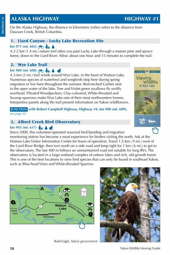
3. Albert Creek Bird Observatory km 993 (mi. 617) Since 2000, this volunteer-operated seasonal bird-banding and migration monitoring station has become a must experience for birders visiting the north. Ask at the Watson Lake Visitor Information Centre for hours of operation. Travel 1.5 km (.9 mi.) west of the Liard River Bridge, then turn north on a side road and keep right for 1 km (.6 mi.) to get to the observatory. The last 400 m follows an unmaintained road not suitable for long RVs. The observatory is located in a large wetland complex of oxbow lakes and rich, old-growth forest. This is one of the best locations to view bird species that can only be found in southeast Yukon, such as Blue-head Vireo and White-throated Sparrow.
Bald Eagle, Yukon government
WatsonLake
Watson Lake
Watson Lake
Alaska Highway
4
Upper Liard
1
1
23
River
Liard
0 5
kilometres
HIG
HW
AY
#1
Alaska Highway Highway #1
Yukon Wildlife Viewing Guide 19
Little Rancheria Caribou Herdkm 992-1063 (mi. 616-660) This is the winter range of the Little Rancheria Caribou Herd that moves between Yukon and northern British Columbia. From October to late winter, caribou are often seen along the highway. Please slow down when you find animals in the area and do not chase or harass them. Vehicle collisions with caribou are infrequent but they do happen.
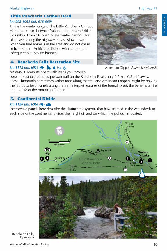
4. Rancheria Falls Recreation Sitekm 1112 (mi. 691) An easy, 10-minute boardwalk leads you through boreal forest to a picturesque waterfall on the Rancheria River, only 0.5 km (0.3 mi.) away. Least Chipmunks sometimes gather food along the trail and American Dippers might be braving the rapids to feed. Panels along the trail interpret features of the boreal forest, the benefits of fire and the life of the American Dipper.
5. Continental Dividekm 1120 (mi. 696) Interpretive panels here describe the distinct ecosystems that have formed in the watersheds to each side of the continental divide, the height of land on which the pullout is located.
American Dipper, Adam Skrutkowski
Rancheria Falls, Ryan Agar
0 20
kilometres
1
WatsonLake
Rancheria River
Alaska Highway
Liard River
Frances R
Ross River
YukonB.C.
Robert Cam
pbell Hwy
Little RancheriaCaribou Herd
Big Creek
UpperLiard
Rancheria
37
4
2 1345
HIG
HW
AY
#1
Alaska Highway Highway #1
Yukon Wildlife Viewing Guide20
Swan Lake, British ColumbiaKm 1152.1 (mi. 715.8) This rest area resides at the east end of Swan Lake in British Columbia. The pullout includes a view of the wetland below. This is a great place to watch for Common Nighthawks in June. Outhouses and garbage cans are provided, and an interpretive panel speaks to the geology of the area.
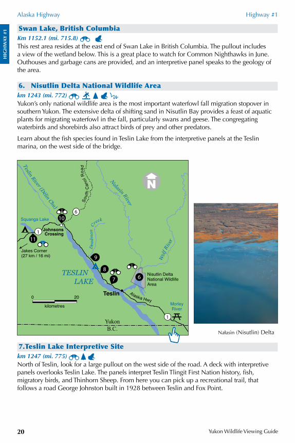
6. Nisutlin Delta National Wildlife Areakm 1243 (mi. 772) Yukon’s only national wildlife area is the most important waterfowl fall migration stopover in southern Yukon. The extensive delta of shifting sand in Nisutlin Bay provides a feast of aquatic plants for migrating waterfowl in the fall, particularly swans and geese. The congregating waterbirds and shorebirds also attract birds of prey and other predators.
Learn about the fish species found in Teslin Lake from the interpretive panels at the Teslin marina, on the west side of the bridge.
7.Teslin Lake Interpretive Sitekm 1247 (mi. 775) North of Teslin, look for a large pullout on the west side of the road. A deck with interpretive panels overlooks Teslin Lake. The panels interpret Teslin Tlingit First Nation history, fish, migratory birds, and Thinhorn Sheep. From here you can pick up a recreational trail, that follows a road George Johnston built in 1928 between Teslin and Fox Point.
Na¬asìn (Nisutlin) Delta
6
Teslin River (Délin Chu)
Alaska Hwy
Nalasìn River
Dea
dman
C
reek
Wol
f Rive
r
Sout
h C
anol
Roa
d
0 20
kilometres
Nisutlin DeltaNational WildlifeArea
YukonB.C.
Squanga Lake
TESLIN LAKE
Teslin
JohnsonsCrossing
Jakes Corner (27 km / 16 mi)
MorleyRiver
1
9
7
8
10
11
6
1
HIG
HW
AY
#1
Alaska Highway Highway #1
Yukon Wildlife Viewing Guide 21
8. Teslin Lake Campground and Bird Observatory km 1258 (mi. 782) A 200-m (.1 mi.) trail starts near the campground cook shelter and leads to the lakeshore where migrating birds are banded using mist-nets, or simply counted as they pass by. This volunteer-operated seasonal bird-banding and migration monitoring station is occupied daily from 6 a.m. until noon, August 1 to October 1 (weather permitting). During the fall, large numbers of songbirds move south along the lakeshore and waterbirds migrate over the lake. Sparrows, fly-catchers and warblers are the most common birds found here. Visitors are encouraged to participate in the ongoing studies.
9. Deadman Creekkm 1273 (mi. 791) Watch for a small group of Thinhorn Sheep on the east side of the highway near Deadman Creek. Sheep near Deadman Creek are lightly coloured – biologists have yet to do the DNA tests needed to decide who these sheep are related to.
JUNCTION with the South Canol Road, Highway #6, km 1295 ( mi. 805), see page 54
10. Johnsons Crossing – Teslin Riverkm 1296 (mi. 805) The bridge at Johnsons Crossing is home to a huge Cliff Swallow colony. Trumpeter and Tundra swans and many other species of waterfowl stage in the river during spring migration. In recent years, some swans have been known to survive the winter in the small areas of open water on the river. At the boat launch, an interpretive panel describes the fish of Teslin Lake.
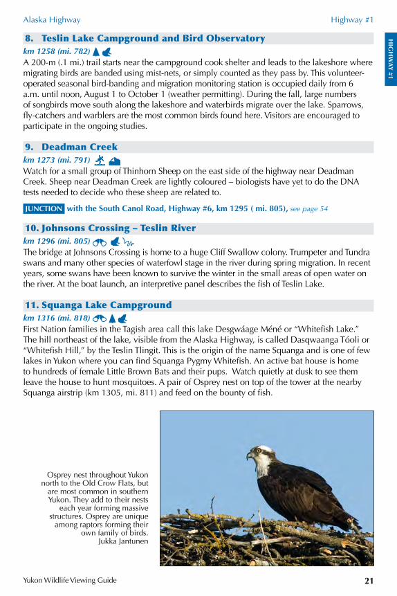
11. Squanga Lake Campgroundkm 1316 (mi. 818) First Nation families in the Tagish area call this lake Desgwáage Méné or “Whitefish Lake.” The hill northeast of the lake, visible from the Alaska Highway, is called Dasqwaanga Tóoli or “Whitefish Hill,” by the Teslin Tlingit. This is the origin of the name Squanga and is one of few lakes in Yukon where you can find Squanga Pygmy Whitefish. An active bat house is home to hundreds of female Little Brown Bats and their pups. Watch quietly at dusk to see them leave the house to hunt mosquitoes. A pair of Osprey nest on top of the tower at the nearby Squanga airstrip (km 1305, mi. 811) and feed on the bounty of fish.
Osprey nest throughout Yukon north to the Old Crow Flats, but
are most common in southern Yukon. They add to their nests
each year forming massive structures. Osprey are unique
among raptors forming their own family of birds.
Jukka Jantunen
HIG
HW
AY
#1
Alaska Highway Highway #1
Yukon Wildlife Viewing Guide22
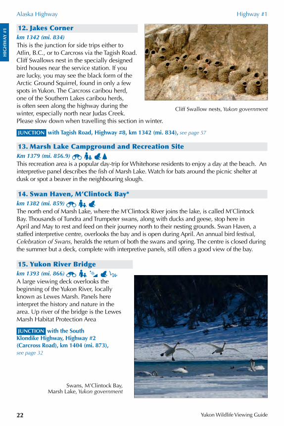
12. Jakes Cornerkm 1342 (mi. 834)This is the junction for side trips either to Atlin, B.C., or to Carcross via the Tagish Road. Cliff Swallows nest in the specially designed bird houses near the service station. If you are lucky, you may see the black form of the Arctic Ground Squirrel, found in only a few spots in Yukon. The Carcross caribou herd, one of the Southern Lakes caribou herds, is often seen along the highway during the winter, especially north near Judas Creek. Please slow down when travelling this section in winter.
JUNCTION with Tagish Road, Highway #8, km 1342 (mi. 834), see page 57
13. Marsh Lake Campground and Recreation SiteKm 1379 (mi. 856.9) This recreation area is a popular day-trip for Whitehorse residents to enjoy a day at the beach. An interpretive panel describes the fish of Marsh Lake. Watch for bats around the picnic shelter at dusk or spot a beaver in the neighbouring slough.
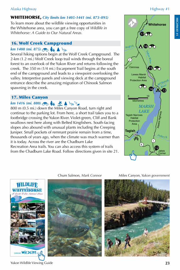
14. Swan Haven, M’Clintock Bay*km 1382 (mi. 859) The north end of Marsh Lake, where the M’Clintock River joins the lake, is called M’Clintock Bay. Thousands of Tundra and Trumpeter swans, along with ducks and geese, stop here in April and May to rest and feed on their journey north to their nesting grounds. Swan Haven, a staffed interpretive centre, overlooks the bay and is open during April. An annual bird festival, Celebration of Swans, heralds the return of both the swans and spring. The centre is closed during the summer but a deck, complete with interpretive panels, still offers a good view of the bay.
15. Yukon River Bridgekm 1393 (mi. 866) A large viewing deck overlooks the beginning of the Yukon River, locally known as Lewes Marsh. Panels here interpret the history and nature in the area. Up river of the bridge is the Lewes Marsh Habitat Protection Area
JUNCTION with the South Klondike Highway, Highway #2 (Carcross Road), km 1404 (mi. 873), see page 32
Swans, M’Clintock Bay, Marsh Lake, Yukon government
Cliff Swallow nests, Yukon government
HIG
HW
AY
#1
Alaska Highway Highway #1
Yukon Wildlife Viewing Guide 23
WHITEHORSE, City limits km 1405-1441 (mi. 873-895)
To learn more about the wildlife viewing opportunities in the Whitehorse area, you can get a free copy of Wildlife in Whitehorse: A Guide to Our Natural Areas.
16. Wolf Creek Campgroundkm 1408 (mi. 875) Several hiking options begin at the Wolf Creek Campground. The 2-km (1.2 mi.) Wolf Creek loop trail winds through the boreal forest to an overlook of the Yukon River and returns following the creek. The 350 m (1/4 mi.) Escarpment Trail begins at the south end of the campground and leads to a viewpoint overlooking the valley. Interpretive panels and viewing deck at the campground entrance describe the amazing migration of Chinook Salmon spawning in the creek.
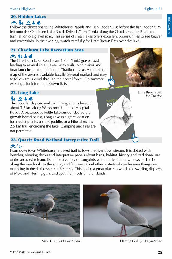
17. Miles Canyonkm 1416 (mi. 880) 800 m (0.5 mi.) down the Miles Canyon Road, turn right and continue to the parking lot. From here, a short trail takes you to a footbridge crossing the Yukon River. Violet-green, Cliff and Bank swallows nest here along with Belted Kingfishers. South-facing slopes also abound with unusual plants including the Creeping Juniper. Small pockets of remnant prairie remain from a time, thousands of years ago, when the climate was much warmer than it is today. Across the river are the Chadburn Lake Recreation Area trails. You can also access this system of trails from the Chadburn Lake Road. Follow directions given in site 21.
Chum Salmon, Mark Connor Miles Canyon, Yukon government
17
16
15
14
12
0 10
kilometres
13
Jakes Corner
Tagish
Whitehorse
Yukon River
MARSHLAKE
Wolf Ck
M’Clintock
River
Lewes Marsh Habitat
Protection Area
Tagish Narrows Habitat
ProtectionArea
Carcross
2
Judas Ck
Alas
ka H
ighw
ay
81
HIG
HW
AY
#1
Alaska Highway Highway #1
Yukon Wildlife Viewing Guide24
18. Millennium Trail and Bert Law Park This 5-km paved interpreted loop trail follows both sides of the Yukon River, between the Robert Campbell Bridge and the Rotary Centennial Bridge. On the east side of the river, the trail leads through forests of spruce, pine and aspen. On the west side, the trail takes you past the S.S. Klondike to Robert Service Campground and Bert Law Park. Bert Law park is known for its unusual diversity of berries. Even this close to the town centre, you may be lucky enough to see Coyote, beaver, Mule Deer or watch salmon in the shallows during August.
19. Whitehorse Rapids and Fish Ladder The Southern Tutchone name for Whitehorse Rapids is Kwanlin. Traditional fish camps were set up in this area before the settlement of the City of Whitehorse. From downtown Whitehorse, walk the Millennium Trail or follow Second Avenue across the Robert Campbell Bridge over the Yukon River. The road becomes Lewes Boulevard. Continue on this road until the road forks at Nisutlin Drive. Turn right and follow Nisutlin Drive to the end. The fish ladder operates from June to early September during the salmon-spawning season. Yukon Energy Corporation and Yukon Fish and Game Association maintain a free interpretive centre at the world’s longest wooden fish ladder. From here, you can climb the trail in front of the fish ladder for a panoramic view of Schwatka Lake and the surrounding mountains. Interpretive panels describe the flora and fauna that thrive on these grassy, south-facing slopes.
Backcountry wildlife viewing: Yukon RiverThe Yukon River is a well travelled canoe route. You can access the river from Rotary Peace Park in Whitehorse. Paddling from Whitehorse to Dawson, a distance of about 750 km (467 mi.), can take from 14 to 21 days. Shorter trips can also be planned. The Yukon River offers a great wildlife appreciation and viewing paddle for any canoe enthusiast. Moose often come to the river to feed. Watch for Black Bears feeding on grasses and berries on south-facing slopes or Bald Eagles nesting on top of trees along the banks. Look at the cliffs north of Minto Landing, where Peregrine Falcons nest.
By the Yukon River in Whitehorse, Yukon government
0 2
kilometres
1
1
21
17
20
19
2322
18
Whitehorse
Yukon River
Nisutlin
Dr
Chadburn Lake Road
Mile
s Ca
nyon
Rd
Robert Ser
vice
Way
LongLake
ChadburnLake
HiddenLakes
EarLake
Long
Lak
e Rd
Alas
ka H
ighw
ay
Hamilton
Blvd
WhitehorseAirport
Schw
atka
Lak
e
HIG
HW
AY
#1
Alaska Highway Highway #1
Yukon Wildlife Viewing Guide 25
20. Hidden Lakes Follow the directions to the Whitehorse Rapids and Fish Ladder. Just before the fish ladder, turn left onto the Chadburn Lake Road. Drive 1.7 km (1 mi.) along the Chadburn Lake Road and turn left onto a gravel road. This series of small lakes offers excellent opportunities to see beaver and waterbirds. In the evening, watch carefully for Little Brown Bats over the lake.
21. Chadburn Lake Recreation Area The Chadburn Lake Road is an 8-km (5-mi.) gravel road leading to several small lakes, with trails, picnic sites and boat launches before ending at Chadburn Lake. A recreation map of the area is available locally. Several marked and easy to follow trails wind through the boreal forest. On summer evenings, look for Little Brown Bats.
22. Long Lake This popular day-use and swimming area is located about 3.5 km along Wickstrom Road (off Hospital Road). A picturesque kettle lake surrounded by old growth boreal forest, Long Lake is a great location for a quiet picnic, a short paddle, or a hike along the 2.5 km trail encircling the lake. Camping and fires are not permitted.
23. Quartz Road Wetland Interpretive Trail From downtown Whitehorse, a paved trail follows the river downstream. It is dotted with benches, viewing decks and interpretive panels about birds, habitat, history and traditional use of the area. Watch and listen for a variety of songbirds which thrive in the willows and alders along the riverbank. In the spring and fall, swans and other waterfowl can be seen flying over or resting in the shallows near the creek. This is also a great place to watch the swirling displays of Mew and Herring gulls and spot their nests on the islands.
Little Brown Bat, Jen Talerico
Herring Gull, Jukka JantunenMew Gull, Jukka Jantunen
Yukon Bats
W i l d l i f ev i e W i n g
HIG
HW
AY
#1
Alaska Highway Highway #1
Yukon Wildlife Viewing Guide26
24. Yukon College Boreal Worlds Trail Hidden behind Yukon College is the Boreal Worlds Trail. You can journey through an aspen grove to the shores of a beaver pond and follow a walk through pine forest with dense lichen patches. This area, with its variety of habitats, is home to many animals including beaver, Common Muskrat, Rusty Blackbird and Common Yellowthroat.
25. Mount McIntyre Ski Trails This is a haven for small boreal forest critters and an important travel corridor for larger mammals. Maps are available outside the ski chalet and at the south end of the Canada Games Centre parking lot. There are viewpoints, benches, interpretive signs and seasonally heated cabins along the signed trails.
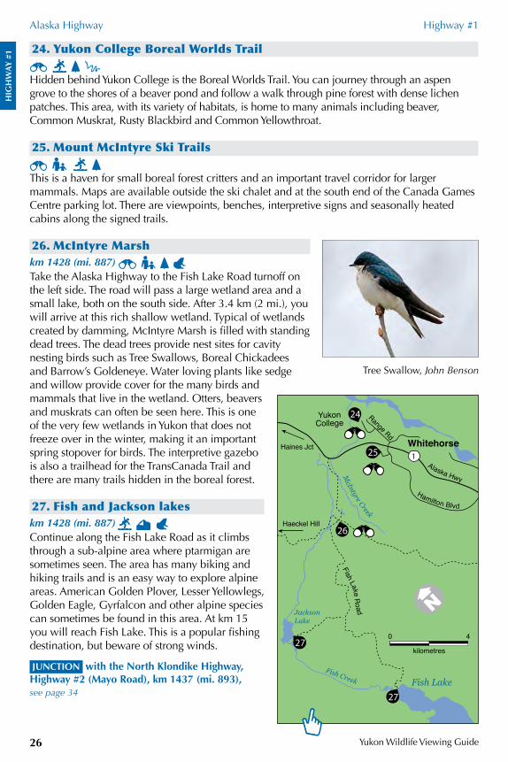
26. McIntyre Marshkm 1428 (mi. 887) Take the Alaska Highway to the Fish Lake Road turnoff on the left side. The road will pass a large wetland area and a small lake, both on the south side. After 3.4 km (2 mi.), you will arrive at this rich shallow wetland. Typical of wetlands created by damming, McIntyre Marsh is filled with standing dead trees. The dead trees provide nest sites for cavity nesting birds such as Tree Swallows, Boreal Chickadees and Barrow’s Goldeneye. Water loving plants like sedge and willow provide cover for the many birds and mammals that live in the wetland. Otters, beavers and muskrats can often be seen here. This is one of the very few wetlands in Yukon that does not freeze over in the winter, making it an important spring stopover for birds. The interpretive gazebo is also a trailhead for the TransCanada Trail and there are many trails hidden in the boreal forest.
27. Fish and Jackson lakeskm 1428 (mi. 887) Continue along the Fish Lake Road as it climbs through a sub-alpine area where ptarmigan are sometimes seen. The area has many biking and hiking trails and is an easy way to explore alpine areas. American Golden Plover, Lesser Yellowlegs, Golden Eagle, Gyrfalcon and other alpine species can sometimes be found in this area. At km 15 you will reach Fish Lake. This is a popular fishing destination, but beware of strong winds.
JUNCTION with the North Klondike Highway, Highway #2 (Mayo Road), km 1437 (mi. 893), see page 34
Tree Swallow, John Benson
0 4
kilometres
1
27
27
26
25
24 Range Rd
YukonCollege
Fish Lake Road Jackson
Lake
Fish Creek Fish Lake
Whitehorse
Hamilton Blvd
Alaska HwyMcIntyre Creek
Haines Jct
Haeckel Hill
HIG
HW
AY
#1
Alaska Highway Highway #1
Yukon Wildlife Viewing Guide 27
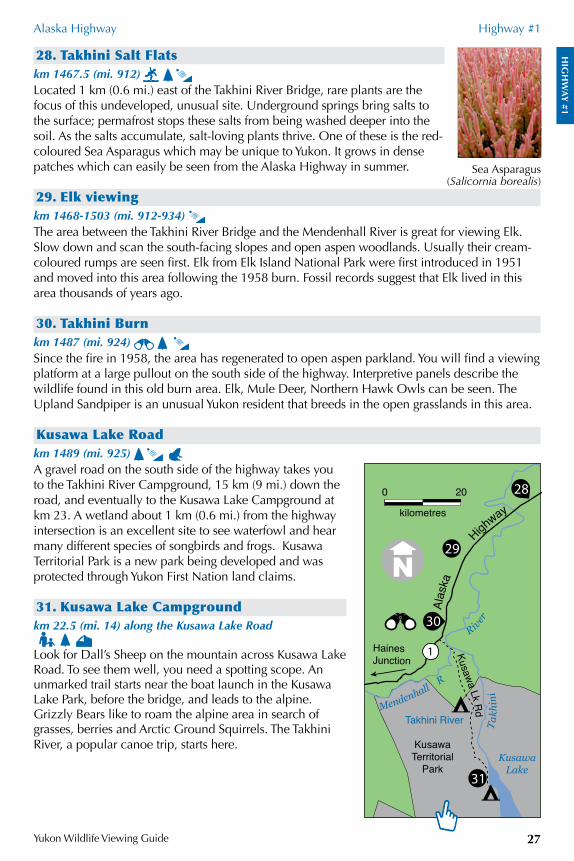
28. Takhini Salt Flatskm 1467.5 (mi. 912) Located 1 km (0.6 mi.) east of the Takhini River Bridge, rare plants are the focus of this undeveloped, unusual site. Underground springs bring salts to the surface; permafrost stops these salts from being washed deeper into the soil. As the salts accumulate, salt-loving plants thrive. One of these is the red-coloured Sea Asparagus which may be unique to Yukon. It grows in dense patches which can easily be seen from the Alaska Highway in summer.
29. Elk viewingkm 1468-1503 (mi. 912-934) The area between the Takhini River Bridge and the Mendenhall River is great for viewing Elk. Slow down and scan the south-facing slopes and open aspen woodlands. Usually their cream-coloured rumps are seen first. Elk from Elk Island National Park were first introduced in 1951 and moved into this area following the 1958 burn. Fossil records suggest that Elk lived in this area thousands of years ago.
30. Takhini Burnkm 1487 (mi. 924) Since the fire in 1958, the area has regenerated to open aspen parkland. You will find a viewing platform at a large pullout on the south side of the highway. Interpretive panels describe the wildlife found in this old burn area. Elk, Mule Deer, Northern Hawk Owls can be seen. The Upland Sandpiper is an unusual Yukon resident that breeds in the open grasslands in this area.
Kusawa Lake Roadkm 1489 (mi. 925) A gravel road on the south side of the highway takes you to the Takhini River Campground, 15 km (9 mi.) down the road, and eventually to the Kusawa Lake Campground at km 23. A wetland about 1 km (0.6 mi.) from the highway intersection is an excellent site to see waterfowl and hear many different species of songbirds and frogs. Kusawa Territorial Park is a new park being developed and was protected through Yukon First Nation land claims.
31. Kusawa Lake Campgroundkm 22.5 (mi. 14) along the Kusawa Lake Road Look for Dall’s Sheep on the mountain across Kusawa Lake Road. To see them well, you need a spotting scope. An unmarked trail starts near the boat launch in the Kusawa Lake Park, before the bridge, and leads to the alpine. Grizzly Bears like to roam the alpine area in search of grasses, berries and Arctic Ground Squirrels. The Takhini River, a popular canoe trip, starts here.
Sea Asparagus (Salicornia borealis)
0 20
kilometres
28
1
29
30
31
HainesJunction
Takh
ini
Mendenhall R
Kusawa Lk Rd
Alas
ka
H
ighway
Kusawa Lake
KusawaTerritorial
Park
Takhini River
River
HIG
HW
AY
#1
Alaska Highway Highway #1
Yukon Wildlife Viewing Guide28
32. The Last Pinekm 1526 (mi. 948) Lodgepole Pine is common in southeast and central Yukon but absent in the north and west. With the exception of some planted trees, these are the last pines you will see on the Alaska Highway.
JUNCTION with Aishihik Road, km 1546 (mi. 960)
Turn north at the Otter Falls Cutoff. This 134 km (84 mi.) rough gravel road winds past majestic mountain views and quiet wetlands. Two highlights are Otter Falls and Aishihik Lake.
i. Otter Falls Recreation Sitekm 28 (mi. 18) along the Aishihik Road On the left side of the Aishihik Road look for a small pullout with a history panel. Once pictured on Canada’s five-dollar bill, the waterfall is easy to access by a short trail. Please note that there are periods of reduced water flow over the falls. Just 100 m past the pullout for the falls, you will find Otter Falls Recreation site. Located on the southern end of Canyon Lake (also called Otter Lake by local residents), this is a perfect place for a picnic. American Dippers can be seen feeding in the falls.
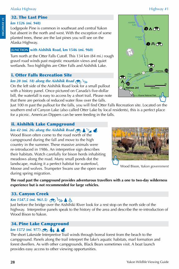
ii. Aishihik Lake Campgroundkm 42 (mi. 26) along the Aishihik Road Wood Bison often come to the road north of the campground during the fall and move to the high country in the summer. These massive animals were re-introduced in 1986. An interpretive sign describes their habitats. Watch carefully for bison herds inhabiting meadows along the road. Many small ponds dot the landscape, making it a perfect habitat for waterfowl, Moose and wolves. Trumpeter Swans use the open water during spring migration.
The road past the campground provides adventurous travellers with a one to two-day wilderness experience but is not recommended for large vehicles.
33. Canyon CreekKm 1547.5 (mi. 961.5) Just before the bridge over the Aishihiki River look for a rest stop on the north side of the highway. Interpretive panels speak to the history of the area and describe the re-introduction of Wood Bison to Yukon.
34. Pine Lake Campgroundkm 1572 (mi. 977) The short Lakeside Interpretive Trail winds through boreal forest from the beach to the campground. Panels along the trail interpret the lake’s aquatic habitats, marl formation and forest dwellers. As with other campgrounds, Black Bears sometimes visit. A boat launch provides easy access to other viewing opportunities.
Wood Bison, Yukon government
0 20
kilometres
1
3
1
ii
i
33
34
32
Dezadeash River
Aishihik River
PineLake
Aishihik Lake
Canyon Lake
Haines Jct
Kluane National Park
AlaskaHighway
HIG
HW
AY
#1
Alaska Highway Highway #1
Yukon Wildlife Viewing Guide 29
35. Da kų Cultural Centre, Kluane National Park and Reserve Visitor Centre and Haines Junction Visitor Information Centre
Km 1577 (mi. 980) Plan to spend several hours at this free interpretive centre all about the Kluane area. Interactive displays and exhibits tell you about the natural and cultural history of the area. Learn about wildlife of the mountains, First Nation traditions, and mountaineering in the St. Elias mountains. The centre is open daily from May to September. Please arrive one hour prior to closing to register all overnight trips.
JUNCTION with the Haines Highway, Highway #3 (Haines Road), km 1579 (mi. 982), see page 40
36. Spruce Beetle Interpretive Trailkm 1597 (mi. 992) An easy 1.7-km (1-mi.) loop interpretive trail examines the life of the Spruce Beetle and its effects on the forests of the area. Allow 35 to 45 minutes to complete the walk.
37. Sulphur Lakekm 1614 (mi. 1003) A large pullout on the north side of the road lets you access this lake. Good canoeing opportunities are available. Thousands of waterbirds use the lake, mostly in late summer. Two Bald Eagle nests grace its shores and Trumpeter Swans are often seen. Try howling for the local wolf pack and see if they respond.
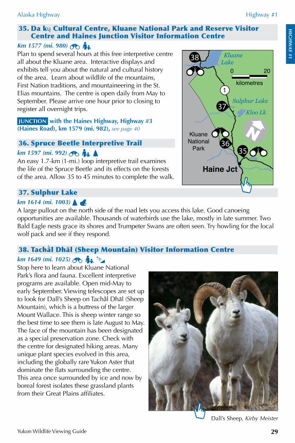
38. Tacha Öl Dha /l (Sheep Mountain) Visitor Information Centrekm 1649 (mi. 1025) Stop here to learn about Kluane National Park’s flora and fauna. Excellent interpretive programs are available. Open mid-May to early September. Viewing telescopes are set up to look for Dall’s Sheep on TachaÖl Dha/l (Sheep Mountain), which is a buttress of the larger Mount Wallace. This is sheep winter range so the best time to see them is late August to May. The face of the mountain has been designated as a special preservation zone. Check with the centre for designated hiking areas. Many unique plant species evolved in this area, including the globally rare Yukon Aster that dominate the flats surrounding the centre. This area once surrounded by ice and now by boreal forest isolates these grassland plants from their Great Plains affiliates.
Dall’s Sheep, Kirby Meister
0 20
kilometres1
37
38
3635
Kloo Lk
Sulphur Lake
Haine Jct
KluaneNational
Park
KluaneLake
HIG
HW
AY
#1
Alaska Highway Highway #1
Yukon Wildlife Viewing Guide30
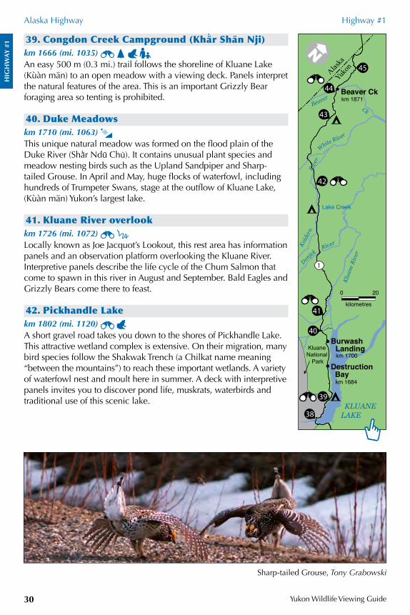
39. Congdon Creek Campground (Kha Ör Sha /n Nji) km 1666 (mi. 1035) An easy 500 m (0.3 mi.) trail follows the shoreline of Kluane Lake (Kùàn män) to an open meadow with a viewing deck. Panels interpret the natural features of the area. This is an important Grizzly Bear foraging area so tenting is prohibited.
40. Duke Meadowskm 1710 (mi. 1063) This unique natural meadow was formed on the flood plain of the Duke River (ShaÖr Ndu/ Chu'). It contains unusual plant species and meadow nesting birds such as the Upland Sandpiper and Sharp-tailed Grouse. In April and May, huge flocks of waterfowl, including hundreds of Trumpeter Swans, stage at the outflow of Kluane Lake, (Kùàn män) Yukon’s largest lake.
41. Kluane River overlookkm 1726 (mi. 1072) Locally known as Joe Jacquot’s Lookout, this rest area has information panels and an observation platform overlooking the Kluane River. Interpretive panels describe the life cycle of the Chum Salmon that come to spawn in this river in August and September. Bald Eagles and Grizzly Bears come there to feast.
42. Pickhandle Lakekm 1802 (mi. 1120) A short gravel road takes you down to the shores of Pickhandle Lake. This attractive wetland complex is extensive. On their migration, many bird species follow the Shakwak Trench (a Chilkat name meaning “between the mountains”) to reach these important wetlands. A variety of waterfowl nest and moult here in summer. A deck with interpretive panels invites you to discover pond life, muskrats, waterbirds and traditional use of this scenic lake.
Sharp-tailed Grouse, Tony Grabowski
0 20
kilometres
38
39
40
41
42
43
44
45
White River
Don
jek River
Alaska
Yukon
KLUANELAKE
Burwash Landing
Destruction Bay
Beaver Ckkm 1871
km 1700
km 1684
Lake Creek
Beaver
Ck
Koid
ern
Klua
ne R
iver
Rive
r
KluaneNational
Park
1
HIG
HW
AY
#1
Alaska Highway Highway #1
Yukon Wildlife Viewing Guide 31
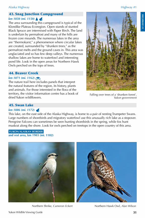
43. Snag Junction Campgroundkm 1850 (mi. 1150) The area surrounding this campground is typical of the Klondike Plateau Ecoregion. Open stands of stunted Black Spruce are intermixed with Paper Birch. The land is underlain by permafrost and many of the hills are frozen core mounds. The numerous lakes in the area are “thermokarst,” a phenomenon where circular lakes are created, surrounded by “drunken trees,” as the permafrost melts and the ground caves in. This area was unglaciated and so has few deep valleys. The numerous shallow lakes are home to waterfowl and interesting pond life. Look in the open areas for Northern Hawk Owls perched on the tops of trees.
44. Beaver Creekkm 1871 (mi. 1162) The nature trail here includes panels that interpret the natural features of the region, its history, plants and animals. For those interested in the flora of the territory, the visitor information centre has a book of dried Yukon wildflowers.
45. Swan Lakekm 1886 (mi. 1172) This lake, on the east side of the Alaska Highway, is home to a pair of nesting Trumpeter Swans. Large numbers of shorebirds and migratory waterfowl use this unusually rich lake as a stopover. Peregrine Falcons can sometimes be seen hunting shorebirds in the spring, while fox hunt muskrat along the shore. Look for owls perched on treetops in the open country of this area.
YUKON/ALASKAN BORDER and rest area, km 1903 (mi. 1182)
Falling over trees of a ‘drunken forest’, Yukon government
Northern Hawk Owl, Alan WilsonNorthern Shrike, Cameron Eckert
HIG
HW
AY
#2S
Yukon Wildlife Viewing Guide32
SOUTH KLONDIKE HIGHWAY HIGHWAY #2The Klondike Highway is divided into the South Klondike (Skagway to Alaska Highway) and North Klondike (Alaska Highway north of Whitehorse to Dawson). Distances are measured from Skagway, Alaska.
The Chilkoot Pass area is home to several amphibian species. Pick up a free Yukon Amphibians guide.
1. B.C./Yukon borderkm 80 (mi. 50) There is a pullout at the B.C./Yukon border, on the east side of the highway. Search the slopes of Montana Mountain to the northwest and Mount Racine to the southwest for signs of Mountain Goats and Dall’s Sheep that frequent these areas in the summer.
2. Conrad Campground and Historic SiteKm 90 (mi. 55.9) A viewing scope near the cook shack and playground is a fantastic vantage point to look for Mountain Goats and Dall’s Sheep on the rocky hillsides. Watch for Golden Eagles and Northern Hawk Owls. A few ruins remain at the adjacent Conrad Historic Site, a city planned for 4000 residents, now enveloped by aspen forest. A popular hiking and biking trail starts south of the campground entrance. The trail was built in 1905 by Sam McGee to service the tramway for one of the silver mines on Montana Mountain.
JUNCTION with the Tagish Road, Highway #8, km 107 (mi. 66.5), see page 56
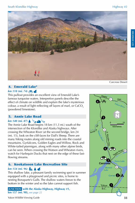
3. Carcross Desert viewpointkm 108 (mi. 67) Affectionately known as the world’s smallest desert, the Carcross Desert is a haven for amateur botanists. There is a viewing deck complete with panels. The wind blows sand from Bennett Lake forming sand dunes and making them advance across the landscape, sometimes burying trees along the way. The active dunes are home to the Yukon Lupine (Lupinus kuschei), and the grass-like Baikal Sedge (Carex sabulosa). Showy Jacob’s-ladder, Pasture Sage, Common Juniper and Kinnikinnick grow in the more stabilized or sheltered areas of the dunes.
Yukon Lupine (Lupinus kuschei), Bruce BennettBaikal Sedge (Carex sabulosa), Yukon government
HIG
HW
AY
#2S
South Klondike Highway Highway #2
Yukon Wildlife Viewing Guide 33
4. Emerald Lake*km 118 (mi. 74) This pullout provides an excellent view of Emerald Lake’s famous turquoise waters. Interpretive panels describe the effect of climate on wildlife and explain the lake’s mysterious colour, a result of light reflecting off layers of marl, or CaCO3 (powdered limestone).
5. Annie Lake Roadkm 140 (mi. 87) The Annie Lake Road begins 18 km (11.3 mi.) south of the intersection of the Klondike and Alaska highways. After crossing the Wheaton River (at the second bridge, km 24 (mi. 15), look on the cliff-faces for Dall’s Sheep. There are many hiking routes along old mining roads into the coastal mountains. Gyrfalcons, Golden Eagles and Willow, Rock and White-tailed ptarmigan, along with many other alpine birds, can be seen. When crossing the Watson and Wheaton rivers, watch for Harlequin Ducks that nest on the edge of these fast-flowing streams.
6. Kookatsoon Lake Recreation Sitekm 154 (mi. 96) This shallow lake, a pleasant family swimming spot in summer equipped with a playground and picnic sites, is home to nesting Bonaparte’s Gulls. The shallow waters freeze to the bottom in the winter and so the lake cannot support fish.
JUNCTION with the Alaska Highway, Highway #1, km 157 (mi. 98), see page 22
Carcross Desert
0 10
kilometres2
1
2
8
1
2
3
4
5
6
Carcross
Watson River
Yukon River
BennettLake
Nares Lake
B.C.Yukon
Tagish Road
Annie LkRd
S. Klondike Hw
y
AlaskaHwy
Conrad
HIG
HW
AY
#2N
Yukon Wildlife Viewing Guide34
NORTH KLONDIKE HIGHWAY HIGHWAY #2Distances are measured from Skagway, Alaska.
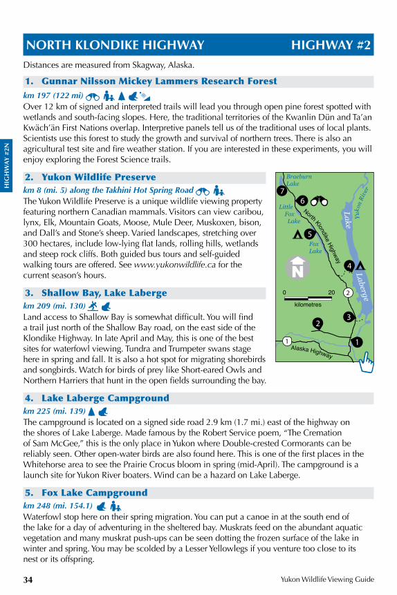
1. Gunnar Nilsson Mickey Lammers Research Forestkm 197 (122 mi) Over 12 km of signed and interpreted trails will lead you through open pine forest spotted with wetlands and south-facing slopes. Here, the traditional territories of the Kwanlin Dün and Ta’an Kwäch’än First Nations overlap. Interpretive panels tell us of the traditional uses of local plants. Scientists use this forest to study the growth and survival of northern trees. There is also an agricultural test site and fire weather station. If you are interested in these experiments, you will enjoy exploring the Forest Science trails.
2. Yukon Wildlife Preservekm 8 (mi. 5) along the Takhini Hot Spring Road The Yukon Wildlife Preserve is a unique wildlife viewing property featuring northern Canadian mammals. Visitors can view caribou, lynx, Elk, Mountain Goats, Moose, Mule Deer, Muskoxen, bison, and Dall’s and Stone’s sheep. Varied landscapes, stretching over 300 hectares, include low-lying flat lands, rolling hills, wetlands and steep rock cliffs. Both guided bus tours and self-guided walking tours are offered. See www.yukonwildlife.ca for the current season’s hours.
3. Shallow Bay, Lake Labergekm 209 (mi. 130) Land access to Shallow Bay is somewhat difficult. You will find a trail just north of the Shallow Bay road, on the east side of the Klondike Highway. In late April and May, this is one of the best sites for waterfowl viewing. Tundra and Trumpeter swans stage here in spring and fall. It is also a hot spot for migrating shorebirds and songbirds. Watch for birds of prey like Short-eared Owls and Northern Harriers that hunt in the open fields surrounding the bay.
4. Lake Laberge Campgroundkm 225 (mi. 139) The campground is located on a signed side road 2.9 km (1.7 mi.) east of the highway on the shores of Lake Laberge. Made famous by the Robert Service poem, “The Cremation of Sam McGee,” this is the only place in Yukon where Double-crested Cormorants can be reliably seen. Other open-water birds are also found here. This is one of the first places in the Whitehorse area to see the Prairie Crocus bloom in spring (mid-April). The campground is a launch site for Yukon River boaters. Wind can be a hazard on Lake Laberge.
5. Fox Lake Campgroundkm 248 (mi. 154.1) Waterfowl stop here on their spring migration. You can put a canoe in at the south end of the lake for a day of adventuring in the sheltered bay. Muskrats feed on the abundant aquatic vegetation and many muskrat push-ups can be seen dotting the frozen surface of the lake in winter and spring. You may be scolded by a Lesser Yellowlegs if you venture too close to its nest or its offspring.
1
23
4
5
67
Yuko
n Ri
ver
FoxLake
Little Fox Lake
BraeburnLake
North Klondike Highway
Alaska Highway
Lake Laberge
1
20 20
kilometres
HIG
HW
AY
#2N
North Klondike Highway Highway #2
Yukon Wildlife Viewing Guide 35
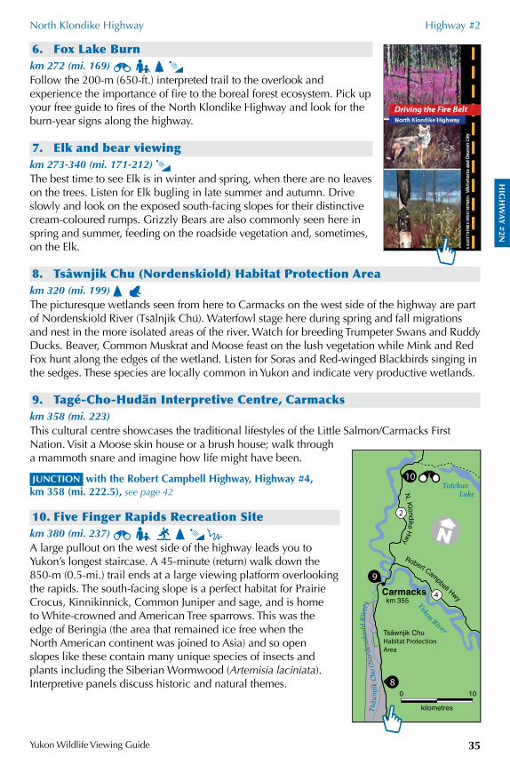
6. Fox Lake Burnkm 272 (mi. 169) Follow the 200-m (650-ft.) interpreted trail to the overlook and experience the importance of fire to the boreal forest ecosystem. Pick up your free guide to fires of the North Klondike Highway and look for the burn-year signs along the highway.
7. Elk and bear viewingkm 273-340 (mi. 171-212) The best time to see Elk is in winter and spring, when there are no leaves on the trees. Listen for Elk bugling in late summer and autumn. Drive slowly and look on the exposed south-facing slopes for their distinctive cream-coloured rumps. Grizzly Bears are also commonly seen here in spring and summer, feeding on the roadside vegetation and, sometimes, on the Elk.
8. Tsâwnjik Chu (Nordenskiold) Habitat Protection Areakm 320 (mi. 199) The picturesque wetlands seen from here to Carmacks on the west side of the highway are part of Nordenskiold River (Tsa\lnjik Chu;). Waterfowl stage here during spring and fall migrations and nest in the more isolated areas of the river. Watch for breeding Trumpeter Swans and Ruddy Ducks. Beaver, Common Muskrat and Moose feast on the lush vegetation while Mink and Red Fox hunt along the edges of the wetland. Listen for Soras and Red-winged Blackbirds singing in the sedges. These species are locally common in Yukon and indicate very productive wetlands.
9. Tagé-Cho-Hudän Interpretive Centre, Carmackskm 358 (mi. 223)This cultural centre showcases the traditional lifestyles of the Little Salmon/Carmacks First Nation. Visit a Moose skin house or a brush house; walk through a mammoth snare and imagine how life might have been.
JUNCTION with the Robert Campbell Highway, Highway #4, km 358 (mi. 222.5), see page 42
10. Five Finger Rapids Recreation Sitekm 380 (mi. 237) A large pullout on the west side of the highway leads you to Yukon’s longest staircase. A 45-minute (return) walk down the 850-m (0.5-mi.) trail ends at a large viewing platform overlooking the rapids. The south-facing slope is a perfect habitat for Prairie Crocus, Kinnikinnick, Common Juniper and sage, and is home to White-crowned and American Tree sparrows. This was the edge of Beringia (the area that remained ice free when the North American continent was joined to Asia) and so open slopes like these contain many unique species of insects and plants including the Siberian Wormwood (Artemisia laciniata). Interpretive panels discuss historic and natural themes.
0 10
kilometres
8
9
10
2
4
Yukon River
Tsâw
njik
Chu
(Nor
dens
kiol
d Ri
ver)
Tatchun Lake
Carmacks
Tsâwnjik Chu Habitat Protection Area
Robert Campbell Hwy
N. Klondike Hwy
km 355
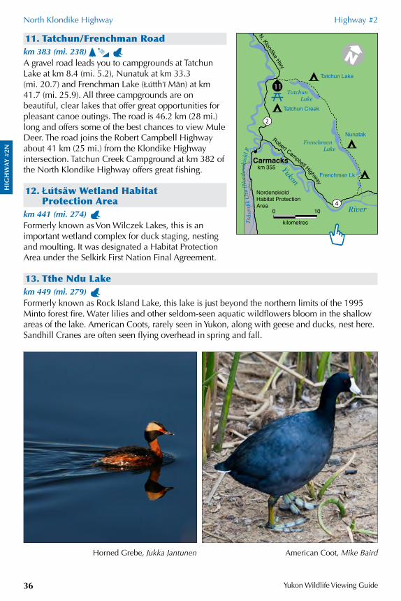
HIG
HW
AY
#2N
North Klondike Highway Highway #2
Yukon Wildlife Viewing Guide36
11. Tatchun/Frenchman Roadkm 383 (mi. 238) A gravel road leads you to campgrounds at Tatchun Lake at km 8.4 (mi. 5.2), Nunatuk at km 33.3 (mi. 20.7) and Frenchman Lake (Òu;tth&ê Ma/n) at km 41.7 (mi. 25.9). All three campgrounds are on beautiful, clear lakes that offer great opportunities for pleasant canoe outings. The road is 46.2 km (28 mi.) long and offers some of the best chances to view Mule Deer. The road joins the Robert Campbell Highway about 41 km (25 mi.) from the Klondike Highway intersection. Tatchun Creek Campground at km 382 of the North Klondike Highway offers great fishing.
12. Òu ;tsa /w Wetland Habitat Protection Area
km 441 (mi. 274) Formerly known as Von Wilczek Lakes, this is an important wetland complex for duck staging, nesting and moulting. It was designated a Habitat Protection Area under the Selkirk First Nation Final Agreement.
13. Tthe Ndu Lakekm 449 (mi. 279) Formerly known as Rock Island Lake, this lake is just beyond the northern limits of the 1995 Minto forest fire. Water lilies and other seldom-seen aquatic wildflowers bloom in the shallow areas of the lake. American Coots, rarely seen in Yukon, along with geese and ducks, nest here. Sandhill Cranes are often seen flying overhead in spring and fall.
American Coot, Mike BairdHorned Grebe, Jukka Jantunen
0 10
kilometres
4
2
11
Tsâw
njik
Chu
(Nor
dens
kiol
d R
Frenchman Lake
Tatchun Lake
Carmacks
N. Klondike Hwy
Robert Campbell HighwayTatchun Lake
Nunatak
Frenchman Lkkm 355
Tatchun CreekYukon
River
Nordenskiold Habitat Protection Area
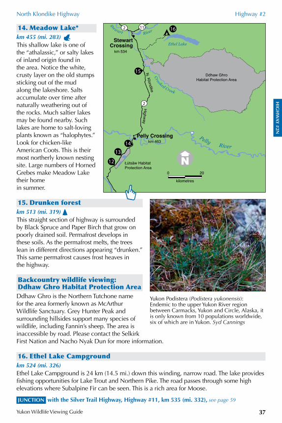
HIG
HW
AY
#2N
North Klondike Highway Highway #2
Yukon Wildlife Viewing Guide 37
14. Meadow Lake*km 455 (mi. 283) This shallow lake is one of the “athalassic,” or salty lakes of inland origin found in the area. Notice the white, crusty layer on the old stumps sticking out of the mud along the lakeshore. Salts accumulate over time after naturally weathering out of the rocks. Much saltier lakes may be found nearby. Such lakes are home to salt-loving plants known as “halophytes.” Look for chicken-like American Coots. This is their most northerly known nesting site. Large numbers of Horned Grebes make Meadow Lake their home in summer.
15. Drunken forestkm 513 (mi. 319) This straight section of highway is surrounded by Black Spruce and Paper Birch that grow on poorly drained soil. Permafrost develops in these soils. As the permafrost melts, the trees lean in different directions appearing “drunken.” This same permafrost causes frost heaves in the highway.
Backcountry wildlife viewing: Ddhaw Ghro Habitat Protection AreaDdhaw Ghro is the Northern Tutchone name for the area formerly known as McArthur Wildlife Sanctuary. Grey Hunter Peak and surrounding hillsides support many species of wildlife, including Fannin’s sheep. The area is inaccessible by road. Please contact the Selkirk First Nation and Nacho Nyak Dun for more information.
16. Ethel Lake Campgroundkm 524 (mi. 326)Ethel Lake Campground is 24 km (14.5 mi.) down this winding, narrow road. The lake provides fishing opportunities for Lake Trout and Northern Pike. The road passes through some high elevations where Subalpine Fir can be seen. This is a rich area for Moose.
JUNCTION with the Silver Trail Highway, Highway #11, km 535 (mi. 332), see page 59
Yukon Podistera (Podistera yukonensis): Endemic to the upper Yukon River region between Carmacks, Yukon and Circle, Alaska, it is only known from 10 populations worldwide, six of which are in Yukon. Syd Cannings
0 20
kilometres
162 11
2
12
13
14
15
Crooked Creek
Stewart
Ethel Lake
Pelly Crossing
Ddhaw GhroHabitat Protection Area
Łútsäw HabitatProtection Area
km 463
km 534
StewartCrossing
N. Klondike
River
Pelly River
Highw
ay
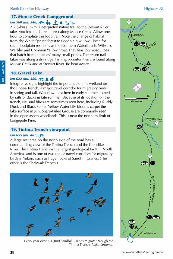
HIG
HW
AY
#2N
North Klondike Highway Highway #2
Yukon Wildlife Viewing Guide38
17. Moose Creek Campgroundkm 560 (mi. 348) A 2.5-km (1.5-mi.) interpreted nature trail to the Stewart River takes you into the boreal forest along Moose Creek. Allow one hour to complete this loop trail. Note the change of habitat from dry White Spruce forest to floodplain willow. Listen for such floodplain residents as the Northern Waterthrush, Wilson’s Warbler and Common Yellowthroat. They feast on mosquitoes that hatch from the areas’ many small ponds. The return trail takes you along a dry ridge. Fishing opportunities are found along Moose Creek and at Stewart River. Be bear aware.
18. Gravel Lakekm 622 (mi. 386) Interpretive signs highlight the importance of this wetland on the Tintina Trench, a major travel corridor for migratory birds in spring and fall. Waterfowl nest here in early summer, joined by rafts of ducks in late summer. Because of its location on the trench, unusual birds are sometimes seen here, including Ruddy Duck and Black Scoter. Yellow Water Lily blooms carpet the lake surface in July. Sharp-tailed Grouse are commonly seen in the open aspen woodlands. This is near the northern limit of Lodgepole Pine.
19. Tintina Trench viewpointkm 655 (mi. 407) A large rest area on the north side of the road has a commanding view of the Tintina Trench and the Klondike River. The Tintina Trench is the largest geological fault in North America, and is one of two major travel corridors for migratory birds in Yukon, such as huge flocks of Sandhill Cranes. (The other is the Shakwak Trench.)
Every year over 250,000 Sandhill Cranes migrate through the Tintina Trench, Jukka Jantunen
0 10
kilometres
2
17
19
205
9
21
18
22
Yukon
R
Klondike River
N Klondike R
Klondike River
Stewart River
Dome Road
North Klo ndike H
ighway
Dawson
Whitehorse
F
Dempster Hwy
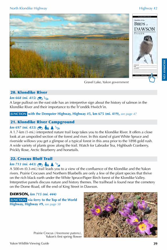
HIG
HW
AY
#2N
North Klondike Highway Highway #2
Yukon Wildlife Viewing Guide 39
Gravel Lake, Yukon government
20. Klondike Riverkm 668 (mi. 415) A large pullout on the east side has an interpretive sign about the history of salmon in the Klondike River and their importance to the Tr’ondëk Hwëch’in.
JUNCTION with the Dempster Highway, Highway #5, km 675 (mi. 419), see page 47
21. Klondike River Campgroundkm 697 (mi. 433) A 1.7-km (1-mi.) interpreted nature trail loop takes you to the Klondike River. It offers a close look at an unspoiled section of the forest and river. In this stand of giant White Spruce and riverside willows you get a glimpse of a typical forest in this area prior to the 1898 gold rush. A wide variety of plants grow along the trail. Watch for Labrador Tea, Highbush Cranberry, Prickly Rose, Arctic Bearberry and horsetails.
22. Crocus Bluff Trailkm 713 (mi. 443) A 500-m (0.3-mi.) trail leads you to a view of the confluence of the Klondike and the Yukon rivers. Prairie Crocuses and Northern Bluebells are only a few of the plant species that thrive on the rich black earth under the White Spruce/Paper Birch forest of the Klondike Valley. Interpretive panels discuss nature and history themes. The trailhead is found near the cemetery on the Dome Road, off the end of King Street in Dawson.
DAWSON, km 715 (mi. 444)
JUNCTION via ferry to the Top of the World Highway, Highway #9, see page 58
Prairie Crocus (Anemone patens), Yukon’s first spring flower
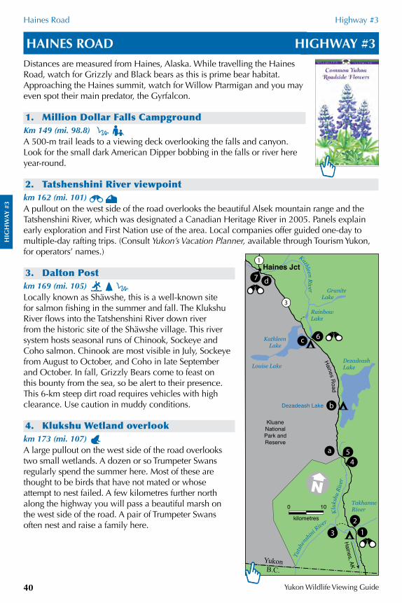
HIG
HW
AY
#3
Haines Road Highway #3
Yukon Wildlife Viewing Guide40
HAINES ROAD HIGHWAY #3Distances are measured from Haines, Alaska. While travelling the Haines Road, watch for Grizzly and Black bears as this is prime bear habitat. Approaching the Haines summit, watch for Willow Ptarmigan and you may even spot their main predator, the Gyrfalcon.
1. Million Dollar Falls CampgroundKm 149 (mi. 98.8) A 500-m trail leads to a viewing deck overlooking the falls and canyon. Look for the small dark American Dipper bobbing in the falls or river here year-round.
2. Tatshenshini River viewpointkm 162 (mi. 101) A pullout on the west side of the road overlooks the beautiful Alsek mountain range and the Tatshenshini River, which was designated a Canadian Heritage River in 2005. Panels explain early exploration and First Nation use of the area. Local companies offer guided one-day to multiple-day rafting trips. (Consult Yukon’s Vacation Planner, available through Tourism Yukon, for operators’ names.)
3. Dalton Postkm 169 (mi. 105) Locally known as Shäwshe, this is a well-known site for salmon fishing in the summer and fall. The Klukshu River flows into the Tatshenshini River down river from the historic site of the Shäwshe village. This river system hosts seasonal runs of Chinook, Sockeye and Coho salmon. Chinook are most visible in July, Sockeye from August to October, and Coho in late September and October. In fall, Grizzly Bears come to feast on this bounty from the sea, so be alert to their presence. This 6-km steep dirt road requires vehicles with high clearance. Use caution in muddy conditions.
4. Klukshu Wetland overlookkm 173 (mi. 107) A large pullout on the west side of the road overlooks two small wetlands. A dozen or so Trumpeter Swans regularly spend the summer here. Most of these are thought to be birds that have not mated or whose attempt to nest failed. A few kilometres further north along the highway you will pass a beautiful marsh on the west side of the road. A pair of Trumpeter Swans often nest and raise a family here.
0 10
kilometres
1
3
13
2
45a
1
Tats
hensh
ini River
Kathleen River
Kluk
shu
Rive
r
DezadeashLake
RainbowLake
GraniteLake
Kathleen Lake
Louise Lake
TakhanneRiver
Haines Road
KluaneNationalPark andReserve
Haines Jct
Haines, AKYukonB.C.
Dezadeash Lake b
c 6
d7
HIG
HW
AY
#3
Haines Road Highway #3
Yukon Wildlife Viewing Guide 41
5. Klukshu Riverkm 182 (mi. 113) This area is frequented by Grizzly Bears. A stop here and a careful scan of the area may reveal one of these bruins or their sign.
6. Kathleen River bridgekm 221 (mi. 137) A pullout on the east side of the road provides access to Kathleen River. There are panels here explaining fish use. From here, you can canoe into Lower Kathleen and Rainbow lakes. This is an easy paddle that requires a half-day to complete. Canoeing below Rainbow Lake requires whitewater experience. You can also paddle to the southwest side of Rainbow Lake. To come out, look for a cabin to the west of Rainbow Lake. You will find an old dock to the south of the cabin. A rough dirt road off the Haines Road about 4.5 km (2.8 mi.) north of the bridge goes down towards the lake. You will need to portage your canoe nearly 1 km (0.6 mi.) as the road becomes impassable to vehicles as it approaches the lake.
7. Dezadeash River Trailkm 245 (mi. 152) A 5.5-km (3-mi.) trail leads you into the forest. From ducks to Moose, you may encounter a variety of animals on this easy walk. You will need about two hours to complete it. This is a good location for winter wildlife viewing as the open water attracts a variety of wildlife. The parking lot and trailhead are on the Haines Highway #3, about 500 m (0.3 mi.) south of the intersection with the Alaska Highway, on the west side of the road. Be sure to visit the swallow condominiums and interpretive signs visible from the parking lot.
JUNCTION with the Alaska Highway, Highway #1, at Haines Junction, km 246 (mi. 153), see page 29
Grizzly Bear, Yukon government
During summer, Red-tailed Hawks
are the most common hawks
seen along Yukon highways,
Jukka Jantunen
“Kluane National Park and Reserve day trips”
Look for trailheads along the highway for day hikes into the national park. Visit the park information centres for maps and safety information.
a) St. Elias Lake – km 185 (mi. 115)
b) Rock Glacier viewpoint – km 202.3 (mi. 125.7)
c) Kathleen Lake Campground – km 219.6 (mi. 136.5)
d) Auriol trail – km 239.1 (mi. 148.6)
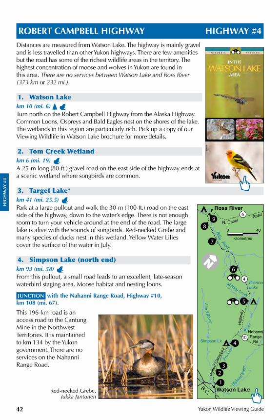
HIG
HW
AY
#4
Yukon Wildlife Viewing Guide42
ROBERT CAMPBELL HIGHWAY HIGHWAY #4Distances are measured from Watson Lake. The highway is mainly gravel and is less travelled than other Yukon highways. There are few amenities but the road has some of the richest wildlife areas in the territory. The highest concentration of moose and wolves in Yukon are found in this area. There are no services between Watson Lake and Ross River (373 km or 232 mi.).
1. Watson Lakekm 10 (mi. 6) Turn north on the Robert Campbell Highway from the Alaska Highway. Common Loons, Ospreys and Bald Eagles nest on the shores of the lake. The wetlands in this region are particularly rich. Pick up a copy of our Viewing Wildlife in Watson Lake brochure for more details.
2. Tom Creek Wetlandkm 6 (mi. 19) A 25-m long (80-ft.) gravel road on the east side of the highway ends at a scenic wetland where songbirds are common.
3. Target Lake*km 41 (mi. 25.5) Park at a large pullout and walk the 30-m (100-ft.) road on the east side of the highway, down to the water’s edge. There is not enough room to turn your vehicle around at the end of the road. The large lake is alive with the sounds of songbirds. Red-necked Grebe and many species of ducks nest in this wetland. Yellow Water Lilies cover the surface of the water in July.
4. Simpson Lake (north end)km 93 (mi. 58) From this pullout, a small road leads to an excellent, late-season waterbird staging area, Moose habitat and nesting loons.
JUNCTION with the Nahanni Range Road, Highway #10, km 108 (mi. 67).
This 196-km road is an access road to the Cantung Mine in the Northwest Territories. It is maintained to km 134 by the Yukon government. There are no services on the Nahanni Range Road.
Red-necked Grebe, Jukka Jantunen
0 40
kilometres
6
28
10
4
9
7
6
5
4
32
1
N. Canol
Liard River Pelly River
Money Creek
Hyland Riv
er
FrancesLake
F
Simpson Lk
NahanniRange
Rd
Ross River
Watson Lake
Road
Fran
ces
River
B.C.
Robe
rt Ca
mpb
ell
Hig
hway
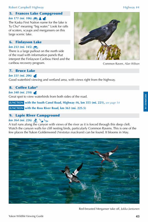
HIG
HW
AY
#4
Robert Campbell Highway Highway #4
Yukon Wildlife Viewing Guide 43
5. Frances Lake Campgroundkm 171 (mi. 106) The Kaska First Nation name for the lake is Tu Chu* meaning “big water.” Look for rafts of scoters, scaups and mergansers on this large scenic lake.
6. Finlayson Lakekm 233 (mi. 145) There is a large pullout on the north side of the road with information panels that interpret the Finlayson Caribou Herd and the caribou recovery program.
7. Bruce Lakekm 331 (mi. 206) Good waterbird viewing and wetland area, with views right from the highway.
8. Coffee Lake*km 348 (mi. 210) Great spot to view waterbirds from both sides of the road.
JUNCTION with the South Canol Road, Highway #6, km 355 (mi. 221), see page 54
JUNCTION with the Ross River Road, km 363 (mi. 225.5)
9. Lapie River Campgroundkm 364 (mi. 226) A trail runs along the canyon with views of the river as it is forced through this deep cleft. Watch the canyon walls for cliff nesting birds, particularly Common Ravens. This is one of the few places the Yukon Goldenweed (Nestotus macleanii) can be found. It blooms in May.
Common Raven, Alan Wilson
Red-breasted Merganser take off, Jukka Jantunen
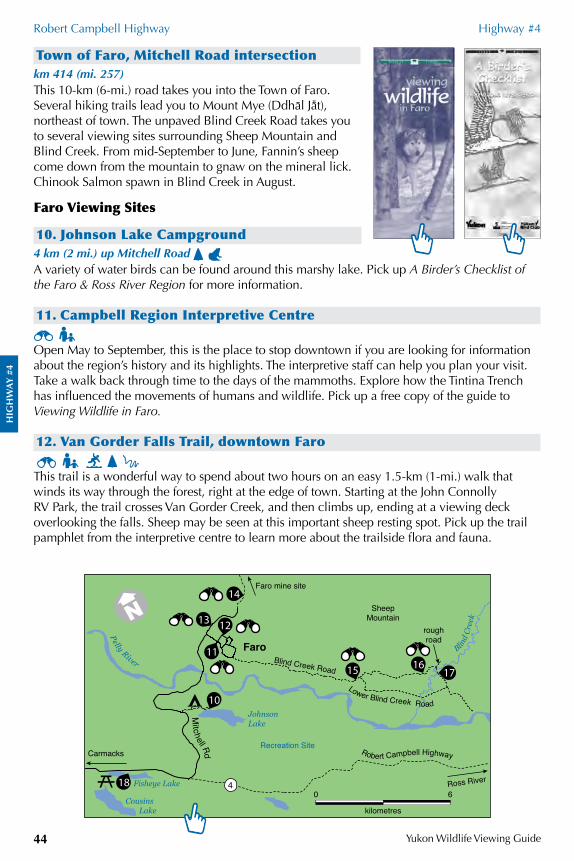
HIG
HW
AY
#4
Robert Campbell Highway Highway #4
Yukon Wildlife Viewing Guide44
Town of Faro, Mitchell Road intersectionkm 414 (mi. 257)This 10-km (6-mi.) road takes you into the Town of Faro. Several hiking trails lead you to Mount Mye (Ddha/l JaÜt), northeast of town. The unpaved Blind Creek Road takes you to several viewing sites surrounding Sheep Mountain and Blind Creek. From mid-September to June, Fannin’s sheep come down from the mountain to gnaw on the mineral lick. Chinook Salmon spawn in Blind Creek in August.
Faro Viewing Sites
10. Johnson Lake Campground4 km (2 mi.) up Mitchell Road A variety of water birds can be found around this marshy lake. Pick up A Birder’s Checklist of the Faro & Ross River Region for more information.
11. Campbell Region Interpretive Centre Open May to September, this is the place to stop downtown if you are looking for information about the region’s history and its highlights. The interpretive staff can help you plan your visit. Take a walk back through time to the days of the mammoths. Explore how the Tintina Trench has influenced the movements of humans and wildlife. Pick up a free copy of the guide to Viewing Wildlife in Faro.
12. Van Gorder Falls Trail, downtown Faro This trail is a wonderful way to spend about two hours on an easy 1.5-km (1-mi.) walk that winds its way through the forest, right at the edge of town. Starting at the John Connolly RV Park, the trail crosses Van Gorder Creek, and then climbs up, ending at a viewing deck overlooking the falls. Sheep may be seen at this important sheep resting spot. Pick up the trail pamphlet from the interpretive centre to learn more about the trailside flora and fauna.
0 6
kilometres
4
Recreation Site
218
10
15 1617
14
1213
11
Mitchell Rd Robert Campbell Highway
Blind
Cree
k
Lower Blind Creek Road JohnsonLake
Cousins Lake
Fisheye Lake
Carmacks
Faro mine site
roughroad
Ross River
FaroBlind Creek Road
Pelly River
SheepMountain
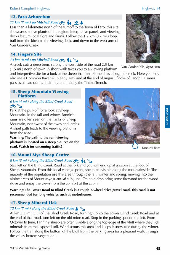
HIG
HW
AY
#4
Robert Campbell Highway Highway #4
Yukon Wildlife Viewing Guide 45
13. Faro Arboretum11 km (7 mi.) up Mitchell Road Less than a kilometre north of the turnoff to the Town of Faro, this site showcases native plants of the region. Interpretive panels and viewing decks feature local flora and fauna. Follow the 1.2 km (0.7 mi.) loop trail from the kiosk to the viewing deck, and down to the west arm of Van Gorder Creek.
14. Fingers Site13 km (8 mi.) up Mitchell Road A creek cuts a deep trench along the west side of the road 2.5 km (1.5 mi.) north of town. A short walk takes you to a viewing platform and interpretive site for a look at the sheep that inhabit the cliffs along the creek. Here you may also see a Common Raven’s. In early May and at the end of August, flocks of Sandhill Cranes pass overhead during their migration along the Tintina Trench.
15. Sheep Mountain Viewing Platform
6 km (4 mi.) along the Blind Creek Road
Park at the pull-off for a look at Sheep Mountain. In the fall and winter, Fannin’s rams are often seen on the flanks of Sheep Mountain, northwest of the ewes and lambs. A short path leads to the viewing platform from the road.Warning: The path to the ram viewing platform is located on a steep S-curve on the road. Watch for oncoming traffic!
16. Mount Mye Sheep Centre8 km (5 mi.) along the Blind Creek Road Stay left on the Blind Creek Road at the fork and you will end up at a cabin at the foot of Sheep Mountain. From this ideal vantage point, sheep are visible along the mountainside. The majority of the population use this area through the fall, winter and spring, moving into the alpine areas of Mount Mye (Ddha/l JaÜt) in June. On cold days bring some firewood for the wood stove and enjoy the views from the comfort of the cabin.
Warning: The Lower Road to Blind Creek is a rough 2-wheel drive gravel road. This road is not recommended for long vehicles such as motorhomes.
17. Sheep Mineral Lick12 km (7 mi.) along the Blind Creek Road At km 5.5 (mi. 3.5) of the Blind Creek Road, turn right onto the Lower Blind Creek Road and at the end of that road, turn left on the old mine road. Stop in the parking spot on the left. From October to June, Fannin’s sheep are often visible along the top edge of the bluff where they lick minerals from the exposed soil. Wind scours this area and keeps it snow-free during the winter. Follow the trail along the bottom of the bluff from the parking area for a pleasant walk through the valley bottom vegetation.
Van Gorder Falls, Ryan Agar
Fannin’s Ram
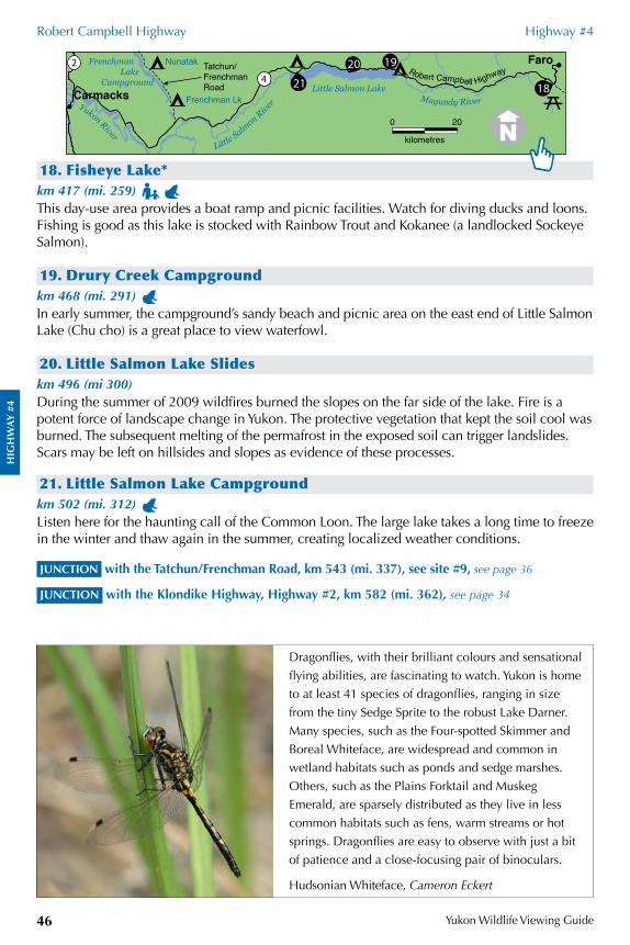
HIG
HW
AY
#4
Robert Campbell Highway Highway #4
Yukon Wildlife Viewing Guide46
HIG
HW
AY
#4
18. Fisheye Lake*km 417 (mi. 259) This day-use area provides a boat ramp and picnic facilities. Watch for diving ducks and loons. Fishing is good as this lake is stocked with Rainbow Trout and Kokanee (a landlocked Sockeye Salmon).
19. Drury Creek Campgroundkm 468 (mi. 291) In early summer, the campground’s sandy beach and picnic area on the east end of Little Salmon Lake (Chu cho) is a great place to view waterfowl.
20. Little Salmon Lake Slideskm 496 (mi 300) During the summer of 2009 wildfires burned the slopes on the far side of the lake. Fire is a potent force of landscape change in Yukon. The protective vegetation that kept the soil cool was burned. The subsequent melting of the permafrost in the exposed soil can trigger landslides. Scars may be left on hillsides and slopes as evidence of these processes.
21. Little Salmon Lake Campgroundkm 502 (mi. 312) Listen here for the haunting call of the Common Loon. The large lake takes a long time to freeze in the winter and thaw again in the summer, creating localized weather conditions.
JUNCTION with the Tatchun/Frenchman Road, km 543 (mi. 337), see site #9, see page 36
JUNCTION with the Klondike Highway, Highway #2, km 582 (mi. 362), see page 34
Hudsonian Whiteface, Cameron Eckert
Dragonflies, with their brilliant colours and sensational
flying abilities, are fascinating to watch. Yukon is home
to at least 41 species of dragonflies, ranging in size
from the tiny Sedge Sprite to the robust Lake Darner.
Many species, such as the Four-spotted Skimmer and
Boreal Whiteface, are widespread and common in
wetland habitats such as ponds and sedge marshes.
Others, such as the Plains Forktail and Muskeg
Emerald, are sparsely distributed as they live in less
common habitats such as fens, warm streams or hot
springs. Dragonflies are easy to observe with just a bit
of patience and a close-focusing pair of binoculars.
0 20
kilometres
420 192
21 18Little Salmon Lake
Faro
Carmacks
Tatchun/FrenchmanRoad
Little Salm
on River Yukon River
Robert Campbell Highway
Magundy RiverFrenchman Lk
NunatakFrenchman Lake Campground
DEMPSTER HIGHWAY HIGHWAY #5Distances are measured from the junction with the Klondike Highway.
This highway provides one of North America’s easiest vehicle access routes into the Arctic, but you would be wise to check road conditions. Bring spare tires. Many arctic species that commonly summer and winter along the Dempster may not be found by any other Yukon highway. Watch for Sharp-tailed Grouse that are commonly seen on the first 20 km (12 mi.) of the Dempster Highway.
1. Dempster Highway Informationkm 0.2 (mi. 0.1) A pullout on the east side of the road has an interpretive kiosk with historic and wildlife information on the Dempster Highway.
Tombstone Territorial Parkkm 49 (mi. 30)This point marks the southern boundary of Tombstone Territorial Park. For the next 70 km (42 mi.), you will be travelling through the park. Covering 2,164 km2, this wilderness has been set aside under the Tr’ondëk Hwëch’in Land Claim Agreement.
2. Tombstone Interpretive Centre and Tombstone Mountain Campground
km 72 (mi. 45) Experience the rich natural and cultural history of the Dempster Highway region and Tombstone Territorial Park. The centre is open from late May to mid-September, seven days a week, including holidays. Campfire talks and nature walks are offered regularly. For a schedule of events, check the website or the bulletin board in front of the centre. A wheelchair-accessible, 1-km (0.6-mi) interpretive trail to a beaver pond starts at the southern end of the centre’s parking lot. From the campground, a 900-m (0.5-mi.) interpretive trail introduces you to the tundra. Pick up a copy of The Dempster Highway Travelogue.
HIG
HW
AY
#5
Yukon Wildlife Viewing Guide 47
0 50
kilometres
22
5
61
Eagle Plains
Tsiigehtchic
FtMcPherson
Aklavik
Inuvik
Dem
pste
r Hwy
Mackenzie River
Peel River
Peel R
iver
Hart River
NWT
Yukon
Ogi
lvie
Riv
er
km 732
km 550
km 608
km 369
Rock River
Dawson
TombstoneTerritoral Park
Klondike Rive
r
YukonRiver
Klondike Hwy
Klondike River
Campground
Blackstone River
Engineer Creek
F
F
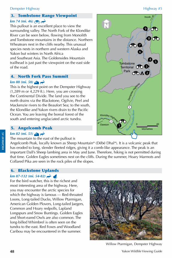
HIG
HW
AY
#5
Dempster Highway Highway #5
Yukon Wildlife Viewing Guide48
3. Tombstone Range Viewpointkm 74 (mi. 46) This pullout is an excellent place to view the surrounding valley. The North Fork of the Klondike River can be seen below, flowing from Monolith and Tombstone mountains in the distance. Northern Wheatears nest in the cliffs nearby. This unusual species nests in northern and western Alaska and Yukon but winters in North Africa and Southeast Asia. The Goldensides Mountain trailhead is just past the viewpoint on the east side of the road.
4. North Fork Pass Summitkm 80 (mi. 50) This is the highest point on the Dempster Highway (1,289 m or 4,229 ft.). Here, you are crossing the Continental Divide. The land you see to the north drains via the Blackstone, Ogilvie, Peel and Mackenzie rivers to the Beaufort Sea; to the south, the Klondike and Yukon rivers drain to the Pacific Ocean. You are leaving the boreal forest of the south and entering unglaciated arctic tundra.
5. Angelcomb Peakkm 82 (mi. 51) The mountain to the east of the pullout is Angelcomb Peak, locally known as Sheep Mountain* (Dëbë Dhal*). It is a volcanic peak that has eroded to long, slender fleeted ridges, giving it a comb-like appearance. The peak is an important Dall’s Sheep lambing area in May and June. Therefore, hiking is not permitted during that time. Golden Eagles sometimes nest on the cliffs. During the summer, Hoary Marmots and Collared Pika are seen in the rock piles of the slopes.
6. Blackstone Uplandskm 87-132 (mi. 54-82) For the bird watcher, this is the richest and most interesting area of the highway. Here, you may encounter the arctic species for which the highway is famous — Red-throated Loons, Long-tailed Ducks, Willow Ptarmigan, American Golden Plovers, Long-tailed Jaegers, Common and Hoary redpolls, Lapland Longspurs and Snow Buntings. Golden Eagles and Short-eared Owls are also common. The long-billed Whimbrel is often seen on the tundra to the east. Red Foxes and Woodland Caribou may be encountered in the summer.
Willow Ptarmigan, Dempster Highway
0 40
kilometres
2
5
1
2
35
4
6
7
9
8
Blac
ksto
ne R
iver
North
Klo
ndik
e R
iver
Dawson
Inuvik
TombstoneTerritorial
Park
Klondike Highway
Dem
pste
r High
way
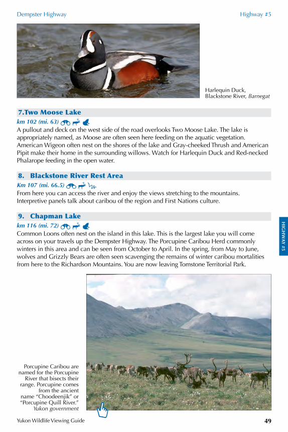
HIG
HW
AY
#5
Dempster Highway Highway #5
Yukon Wildlife Viewing Guide 49
7.Two Moose Lakekm 102 (mi. 63) A pullout and deck on the west side of the road overlooks Two Moose Lake. The lake is appropriately named, as Moose are often seen here feeding on the aquatic vegetation. American Wigeon often nest on the shores of the lake and Gray-cheeked Thrush and American Pipit make their home in the surrounding willows. Watch for Harlequin Duck and Red-necked Phalarope feeding in the open water.
8. Blackstone River Rest AreaKm 107 (mi. 66.5) From here you can access the river and enjoy the views stretching to the mountains. Interpretive panels talk about caribou of the region and First Nations culture.
9. Chapman Lakekm 116 (mi. 72) Common Loons often nest on the island in this lake. This is the largest lake you will come across on your travels up the Dempster Highway. The Porcupine Caribou Herd commonly winters in this area and can be seen from October to April. In the spring, from May to June, wolves and Grizzly Bears are often seen scavenging the remains of winter caribou mortalities from here to the Richardson Mountains. You are now leaving Tomstone Territorial Park.
Harlequin Duck, Blackstone River, Barnegat
Porcupine Caribou are named for the Porcupine
River that bisects their range. Porcupine comes
from the ancientname “Choodeenjik” or “Porcupine Quill River.”
Yukon government
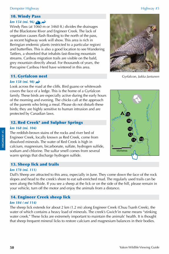
HIG
HW
AY
#5
Dempster Highway Highway #5
Yukon Wildlife Viewing Guide50
10. Windy Passkm 154 (mi. 96) Windy Pass (at 1060 m or 3460 ft.) divides the drainages of the Blackstone River and Engineer Creek. The lack of vegetation causes flash flooding to the north of the pass, as recent highway work will show. This area is rich in Beringian endemic plants (restricted to a particular region) and butterflies. This is also a good location to see Wandering Tattlers, a shorebird that inhabits fast-flowing mountain streams. Caribou migration trails are visible on the bald, grey mountain directly ahead. For thousands of years, the Porcupine Caribou Herd have wintered in this area.
11. Gyrfalcon nestkm 158 (mi. 98) Look across the road at the cliffs. Bird guano or whitewash covers the face of a ledge. This is the home of a Gyrfalcon family. These birds are especially active during the early hours of the morning and evening. The chicks call at the approach of the parents who bring a meal. Please do not disturb these birds; they are highly sensitive to human intrusion and are protected by Canadian laws.
12. Red Creek* and Sulphur Springs km 168 (mi. 104)The reddish-brown stains of the rocks and river bed of Engineer Creek, locally known as Red Creek, come from dissolved minerals. The water of Red Creek is high in calcium, magnesium, bicarbonate, sulfate, hydrogen sulfide, sodium and chlorine. The sulfur smell comes from several warm springs that discharge hydrogen sulfide.
13. Sheep lick and trailskm 178 (mi. 111)Dall’s Sheep are attracted to this area, especially in June. They come down the face of the rock slopes and head to the creek’s shore to eat salt-enriched mud. The regularly used trails can be seen along the hillside. If you see a sheep at the lick or on the side of the hill, please remain in your vehicle, turn off the motor and enjoy the animals from a distance.
14. Engineer Creek sheep lickkm 184 ( mi 114)The sheep lick extends for about 2 km (1.2 mi) along Engineer Creek (Chuu Tsanh Creek), the water of which contains a heavy load of minerals. The creek’s Gwich’in name means “stinking water creek.” These licks are extremely important to maintain the animals’ health. It is thought that sheep frequent mineral licks to restore calcium and magnesium balances in their bodies.
Gyrfalcon, Jukka Jantunen
0 20
kilometres
215
14
13
212
11 10
Blac
ksto
ne R
iver
Ogilvie R
Engineer Creek
5
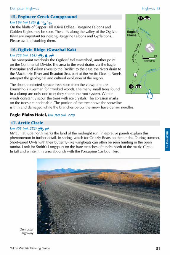
HIG
HW
AY
#5
Dempster Highway Highway #5
Yukon Wildlife Viewing Guide 51
15. Engineer Creek Campgroundkm 194 (mi 120) On the bluffs of Sapper Hill (Divii Ddhaa) Peregrine Falcons and Golden Eagles may be seen. The cliffs along the valley of the Ogilvie River are important for nesting Peregrine Falcons and Gyrfalcons. Please avoid disturbing them.
16. Ogilvie Ridge (Gwazhal Kak)km 259 (mi. 161) This viewpoint overlooks the Ogilvie/Peel watershed, another point on the Continental Divide. The area to the west drains via the Eagle, Porcupine and Yukon rivers to the Pacific; to the east, the rivers drain to the Mackenzie River and Beaufort Sea, part of the Arctic Ocean. Panels interpret the geological and cultural evolution of the region.
The short, contorted spruce trees seen from the viewpoint are krummholz (German for crooked wood). The many small trees found in a clump are only one tree; they share one root system. Winter winds constantly scour the trees with ice crystals. The abrasion marks on the trees are noticeable. The portion of the tree above the snowline is thin and damaged while the branches below the snow have denser needles.
Eagle Plains Hotel, km 369 (mi. 229)
17. Arctic Circlekm 406 (mi. 252) 66°33' latitude north marks the land of the midnight sun. Interpretive panels explain this phenomenon in further detail. In spring, watch for Grizzly Bears on the tundra. During summer, Short-eared Owls with their butterfly-like wingbeats can often be seen hunting in the open tundra. Look for Smith’s Longspurs on the bare stretches of tundra north of the Arctic Circle. In fall and winter, this area abounds with the Porcupine Caribou Herd.
Dempster Highway
0 20
kilometres
16
5
17
Peel River
Eagle River
Eagle
Dem
pste
r Hi
ghwa
y
Plains
HIG
HW
AY
#5
Dempster Highway Highway #5
Yukon Wildlife Viewing Guide52
18. Rock River Campgroundkm 446 (mi. 277) Formerly known as Cornwall Creek, this is a little pocket of boreal forest in an otherwise unforested area. Beyond here you will be travelling in open tundra country. Watch for Northern Wheatears. In winter and early spring, Snowy Owls can be seen in the Richardson Mountains.
19. Yukon/Northwest Territories borderkm 465 (mi 289) You are now leaving the unglaciated landscape of the Eagle Plains. Once you cross the Richardson Mountains you will enter a landscape scoured by the Laurentide ice sheet over 10,000 years ago. Learn more about wildlife, Beringian flora and First Nations history at the kiosk here.
Peel River ferry, km 539 (mi. 335)
Fort McPherson, km 550 (mi. 342)
Mackenzie River ferry, km 608 (mi. 378)
Inuvik, km 736 (mi. 457)
218
17
19
5
Inuvik
Dem
pste
r Hwy
VuntutNational Park
Blow River
Porcupine River Old CrowTsiigehtchic
FortMcPherson
Aklavik
Eagle Plains
Ivvavik National
Park
Ni’iinlii Njik (Fishing Branch)Territorial Park
Herschel IslandTerritorial Park/Qikiqtaruk
BeaufortSea
Ala
ska
Yuko
n
NWTYukon
Arctic Circle
Firt
h River
Old Crow Flats Habitat Protection Area
Mackenzie River
Peele River
Tuktoyaktuk
km 369
km 551
km 736
km 608
0 50
kilometres
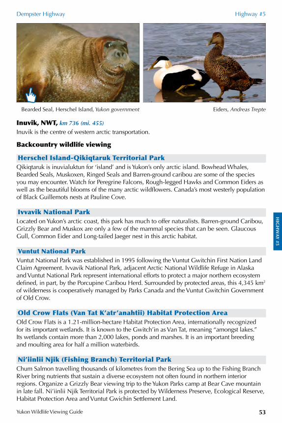
HIG
HW
AY
#5
Dempster Highway Highway #5
Yukon Wildlife Viewing Guide 53
Inuvik, NWT, km 736 (mi. 455)
Inuvik is the centre of western arctic transportation.
Backcountry wildlife viewing
Herschel Island-Qikiqtaruk Territorial ParkQikiqtaruk is inuvialuktun for ‘island’ and is Yukon’s only arctic island. Bowhead Whales, Bearded Seals, Muskoxen, Ringed Seals and Barren-ground caribou are some of the species you may encounter. Watch for Peregrine Falcons, Rough-legged Hawks and Common Eiders as well as the beautiful blooms of the many arctic wildflowers. Canada’s most westerly population of Black Guillemots nests at Pauline Cove.
Ivvavik National ParkLocated on Yukon’s arctic coast, this park has much to offer naturalists. Barren-ground Caribou, Grizzly Bear and Muskox are only a few of the mammal species that can be seen. Glaucous Gull, Common Eider and Long-tailed Jaeger nest in this arctic habitat.
Vuntut National ParkVuntut National Park was established in 1995 following the Vuntut Gwitchin First Nation Land Claim Agreement. Ivvavik National Park, adjacent Arctic National Wildlife Refuge in Alaska and Vuntut National Park represent international efforts to protect a major northern ecosystem defined, in part, by the Porcupine Caribou Herd. Surrounded by protected areas, this 4,345 km2 of wilderness is cooperatively managed by Parks Canada and the Vuntut Gwitchin Government of Old Crow.
Old Crow Flats (Van Tat K’atr’anahtii) Habitat Protection AreaOld Crow Flats is a 1.21-million-hectare Habitat Protection Area, internationally recognized for its important wetlands. It is known to the Gwitch’in as Van Tat, meaning “amongst lakes.” Its wetlands contain more than 2,000 lakes, ponds and marshes. It is an important breeding and moulting area for half a million waterbirds.
Ni’iinlii Njik (Fishing Branch) Territorial ParkChum Salmon travelling thousands of kilometres from the Bering Sea up to the Fishing Branch River bring nutrients that sustain a diverse ecosystem not often found in northern interior regions. Organize a Grizzly Bear viewing trip to the Yukon Parks camp at Bear Cave mountain in late fall. Ni’iinlii Njik Territorial Park is protected by Wilderness Preserve, Ecological Reserve, Habitat Protection Area and Vuntut Gwichin Settlement Land.
Eiders, Andreas TrepteBearded Seal, Herschel Island, Yukon government
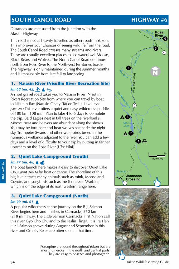
HIG
HW
AY
#6
Yukon Wildlife Viewing Guide54
SOUTH CANOL ROAD HIGHWAY #6Distances are measured from the junction with the Alaska Highway.
This road is not as heavily travelled as other roads in Yukon. This improves your chances of seeing wildlife from the road. The South Canol Road crosses many streams and rivers. These are usually excellent places to see waterfowl, Moose, Black Bears and Wolves. The North Canol Road continues north from Ross River to the Northwest Territories border. The highway is only maintained during the summer months and is impassable from late fall to late spring.
1. Na¬asìn River (Nisutlin River Recreation Site) km 68 (mi. 42) A short gravel road takes you to Na¬asìn River (Nisutlin River) Recreation Site from where you can travel by boat to Nisutlin Bay (Na¬asìn Ghe'yi Ta;) on Teslin Lake. (See page 20.) This river offers a quiet and easy wilderness paddle of 180 km (108 mi.). Plan to take 4 to 6 days to complete the trip. Bald Eagles nest in tall trees on the riverbanks. Moose, bear and beavers are abundant along the shores. You may be fortunate and hear wolves serenade the night sky. Trumpeter Swans and other waterbirds breed in the numerous wetlands adjacent to the river. You can add a few days and a level of difficulty to your trip by putting in farther upstream on the Rose River (Ł’èx Hîni).
2. Quiet Lake Campground (South)km 77 (mi. 48) The boat launch here makes it easy to discover Quiet Lake (Chu Laå¶Kìt Den A) by boat or canoe. The shoreline of this big lake attracts many animals such as mink, Moose and Coyote, and songbirds such as the Tennessee Warbler, which is on the edge of its northwestern range here.
3. Quiet Lake Campground (North)km 99 (mi. 61) A popular wilderness canoe journey on the Big Salmon River begins here and finishes in Carmacks, 350 km (218 mi.) away. The Little Salmon Carmacks First Nation call this river Gyo' Cho Chu; and to the Teslin Tlingit, it is T&a' Tle'n Hôni. Salmon spawn during August and September in this river and Grizzly Bears are often seen at that time.
Porcupine are found throughout Yukon but are most numerous in the north and central parts.
They are easy to observe and photograph.
0 20
kilometres
1
1
22
2
4
25
6
3
6
4
Pelly R
Rose River
Big Salmon River
Nal
asìn
Riv
er
Lapi
e Rive
r
QuietLake
JohnsonsCrossing
RossRiver
Teslin R
South Canol R
oad
HIG
HW
AY
#6
South Canol Road Highway #6
Yukon Wildlife Viewing Guide 55
4. Lapie Lakeskm 163 (mi. 101) These are beautiful lakes to discover by canoe. A short dirt road takes you to a boat launch and an unmaintained camping area on the lake’s shore. Moose often come to graze on the shoreline. Waterfowl and Arctic Terns nest in the shallow bays around the lake. Listen for the call of the Savannah Sparrow in the shrubby willows and grasses around the lakeshore: “Sa sa sa vaaaaaaanah sparrow.”
5. Lapie River Crossing #2km 213 (mi. 132) There is a beautiful view of the Lapie River canyon at the bridge. On the east side of the road, north of the bridge, you will find a pullout with an interpretive panel. From this pullout, look at the mountains to the west across the road. Stone’s Sheep can sometimes be seen sunning themselves on the cliffs. For an even better view of the mountain, walk down the road, south of the bridge. (The Lapie River was named by George Dawson for an Iroquois First Nation canoeman who accompanied Robert Campbell, of the Hudson Bay Co., during his exploration of the Pelly River in 1843.)
JUNCTION with the Robert Campbell Highway, Highway #4, km 219 (mi. 136), see page 42
6. North Canol RoadIn 1943, the American Army and its contractors built the Canol Road as a “tote” or supply road. The road paralleled an oil pipeline from Camp Canol, near the oil wells at Norman Wells, NWT. The pipeline was abandoned in 1945. The North Canol is a seasonal recreation road that provides access to the wilderness of the eastern central Yukon. It stretches 232 km from Ross River to Macmillan Pass, at the NWT border, and can be very steep and narrow at times. If the road gets slippery with rain, you are advised to pull over and wait until the surface dries before carrying on. There are no services on the North Canol. The road passes by several big lakes and the spectacular Itsi Range of mountains. The North Canol travels primarily through the traditional territory of the Kaska First Nation.
Arctic Terns, Jim Hawkings
Savannah Sparrow, one of Yukon’s most widespread sparrows, can be found in any grassy
and shrubby area, S.P. Barrett
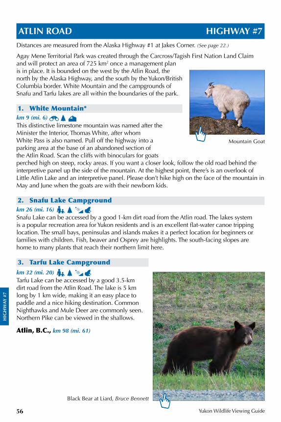
HIG
HW
AY
#7
Yukon Wildlife Viewing Guide56
ATLIN ROAD HIGHWAY #7Distances are measured from the Alaska Highway #1 at Jakes Corner. (See page 22.)
Agay Mene Territorial Park was created through the Carcross/Tagish First Nation Land Claim and will protect an area of 725 km2 once a management plan is in place. It is bounded on the west by the Atlin Road, the north by the Alaska Highway, and the south by the Yukon/British Columbia border. White Mountain and the campgrounds of Snafu and Tarfu lakes are all within the boundaries of the park.
1. White Mountain*km 9 (mi. 6) This distinctive limestone mountain was named after the Minister the Interior, Thomas White, after whom White Pass is also named. Pull off the highway into a parking area at the base of an abandoned section of the Atlin Road. Scan the cliffs with binoculars for goats perched high on steep, rocky areas. If you want a closer look, follow the old road behind the interpretive panel up the side of the mountain. At the highest point, there’s is an overlook of Little Atlin Lake and an interpretive panel. Please don’t hike high on the face of the mountain in May and June when the goats are with their newborn kids.
2. Snafu Lake Campgroundkm 26 (mi. 16) Snafu Lake can be accessed by a good 1-km dirt road from the Atlin road. The lakes system is a popular recreation area for Yukon residents and is an excellent flat-water canoe tripping location. The small bays, peninsulas and islands makes it a perfect location for beginners or families with children. Fish, beaver and Osprey are highlights. The south-facing slopes are home to many plants that reach their northern limit here.
3. Tarfu Lake Campgroundkm 32 (mi. 20) Tarfu Lake can be accessed by a good 3.5-km dirt road from the Atlin Road. The lake is 5 km long by 1 km wide, making it an easy place to paddle and a nice hiking destination. Common Nighthawks and Mule Deer are commonly seen. Northern Pike can be viewed in the shallows.
Atlin, B.C., km 98 (mi. 61)
Mountain Goat
Black Bear at Liard, Bruce Bennett
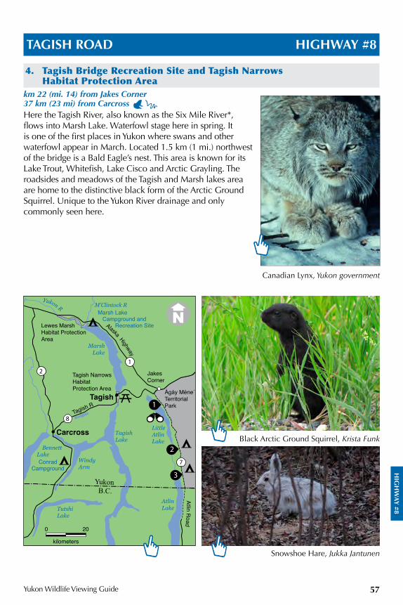
HIG
HW
AY
#8
Yukon Wildlife Viewing Guide 57
TAGISH ROAD HIGHWAY #8
4. Tagish Bridge Recreation Site and Tagish Narrows Habitat Protection Area
km 22 (mi. 14) from Jakes Corner 37 km (23 mi) from Carcross Here the Tagish River, also known as the Six Mile River*, flows into Marsh Lake. Waterfowl stage here in spring. It is one of the first places in Yukon where swans and other waterfowl appear in March. Located 1.5 km (1 mi.) northwest of the bridge is a Bald Eagle’s nest. This area is known for its Lake Trout, Whitefish, Lake Cisco and Arctic Grayling. The roadsides and meadows of the Tagish and Marsh lakes area are home to the distinctive black form of the Arctic Ground Squirrel. Unique to the Yukon River drainage and only commonly seen here.
Black Arctic Ground Squirrel, Krista Funk
Canadian Lynx, Yukon government
Snowshoe Hare, Jukka Jantunen
1
22
23
7
8
21
Conrad Campground
Yukon R
BennettLake
WindyArm
TutshiLake
TagishLake
AtlinLake
LittleAtlinLake
MarshLake
JakesCorner
Tagish
Carcross
M’Clintock R
YukonB.C.
Alaska Highway
Atlin Road
Ágáy Méne´TerritorialPark
Lewes Marsh Habitat ProtectionArea
Tagish Narrows Habitat Protection Area
Marsh Lake Campground and Recreation Site
0 20
kilometers
Tagish R
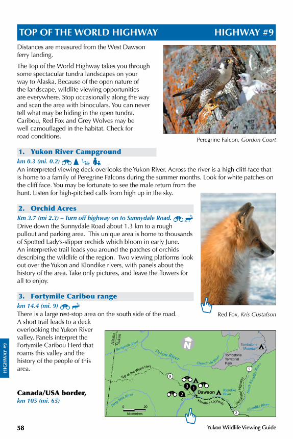
HIG
HW
AY
#9
Yukon Wildlife Viewing Guide58 Yukon Wildlife Viewing Guide58
TOP OF THE WORLD HIGHWAY HIGHWAY #9Distances are measured from the West Dawson ferry landing.
The Top of the World Highway takes you through some spectacular tundra landscapes on your way to Alaska. Because of the open nature of the landscape, wildlife viewing opportunities are everywhere. Stop occasionally along the way and scan the area with binoculars. You can never tell what may be hiding in the open tundra. Caribou, Red Fox and Grey Wolves may be well camouflaged in the habitat. Check for road conditions.
1. Yukon River Campgroundkm 0.3 (mi. 0.2) An interpreted viewing deck overlooks the Yukon River. Across the river is a high cliff-face that is home to a family of Peregrine Falcons during the summer months. Look for white patches on the cliff face. You may be fortunate to see the male return from the hunt. Listen for high-pitched calls from high up in the sky.
2. Orchid AcresKm 3.7 (mi 2.3) – Turn off highway on to Sunnydale Road. Drive down the Sunnydale Road about 1.3 km to a rough pullout and parking area. This unique area is home to thousands of Spotted Lady’s-slipper orchids which bloom in early June. An interpretive trail leads you around the patches of orchids describing the wildlife of the region. Two viewing platforms look out over the Yukon and Klondike rivers, with panels about the history of the area. Take only pictures, and leave the flowers for all to enjoy.
3. Fortymile Caribou rangekm 14.4 (mi. 9) There is a large rest-stop area on the south side of the road. A short trail leads to a deck overlooking the Yukon River valley. Panels interpret the Fortymile Caribou Herd that roams this valley and the history of the people of this area.
Canada/USA border, km 105 (mi. 65)
Red Fox, Kris Gustafson
Peregrine Falcon, Gordon Court
0 20
kilometres 2
5
9
212
3
TombstoneTerritorialPark
Top of the World Hwy
Demps
ter H
ighw
ay
Klondike Highway
Dawson
Tombstone Mountain
KlondikeRiver
Fortymile River
Sixty Mile River
Yukon RiverChandindu Rive
r
Klondike River
Nor
th K
londi
ke R
iver
Ala
ska
Yuko
n
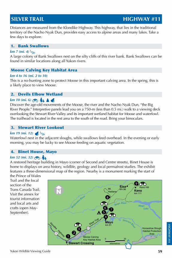
HIG
HW
AY
#11
Yukon Wildlife Viewing Guide 59
SILVER TRAIL HIGHWAY #11Distances are measured from the Klondike Highway. This highway, that lies in the traditional territory of the Nacho Nyak Dun, provides easy access to alpine areas and many lakes. Take a few days to explore.
1. Bank Swallowskm 7 (mi. 4) A large colony of Bank Swallows nest on the silty cliffs of this river bank. Bank Swallows can be found in similar locations along all Yukon rivers.
Moose Calving Key Habitat Areakm 4 to 16 (mi. 2 to 10)This is a no-hunting zone to protect Moose in this important calving area. In the spring, this is a likely place to view Moose.
2. Devils Elbow Wetlandkm 10 (mi. 6) Discover the age-old movements of the Moose, the river and the Nacho Nyak Dun, “the Big River People.” Interpretive panels lead you on a 750-m (less than 0.5 mi.) walk to a viewing deck overlooking the Stewart River Valley and its important wetland habitat for Moose and waterfowl. The trailhead is located in the rest area to the south of the road. Bring your binoculars.
3. Stewart River Lookout km 19 (mi. 12) Waterfowl nest in the adjacent sloughs, while swallows feed overhead. In the evening or early morning, you may be lucky to see Moose feeding on aquatic vegetation.
4. Binet House, Mayokm 52 (mi. 32) A restored heritage building in Mayo (corner of Second and Centre streets), Binet House is home to displays on area history, wildlife, geology and local permafrost studies. The exhibit features a three-dimensional map of the region. Nearby is a monument marking the start of the Prince of Wales Trail and the local section of the Trans Canada Trail. Visit the annex for tourist information and local arts and crafts (open May-September).
Stewart River
McQ
uesten
River
Moose CalvingKey Habitat Area
Stewart Crossing
Silver TrailKlondike Highway
km 51Mayo
Keno HillKeno
Horseshoe SloughHabitat Protection
Area
Mayo Lake
km 111
Mayo River
ElsaMt.Haldane
km 96
22
11
21
3
245
26 7
8
9
0 20
kilometres
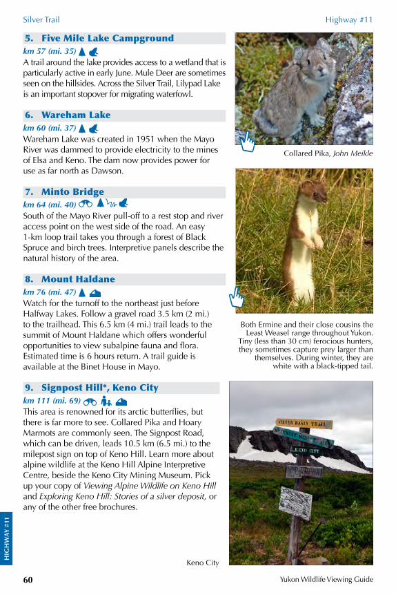
HIG
HW
AY
#11
Silver Trail Highway #11
Yukon Wildlife Viewing Guide60
5. Five Mile Lake Campgroundkm 57 (mi. 35) A trail around the lake provides access to a wetland that is particularly active in early June. Mule Deer are sometimes seen on the hillsides. Across the Silver Trail, Lilypad Lake is an important stopover for migrating waterfowl.
6. Wareham Lakekm 60 (mi. 37) Wareham Lake was created in 1951 when the Mayo River was dammed to provide electricity to the mines of Elsa and Keno. The dam now provides power for use as far north as Dawson.
7. Minto Bridgekm 64 (mi. 40) South of the Mayo River pull-off to a rest stop and river access point on the west side of the road. An easy 1-km loop trail takes you through a forest of Black Spruce and birch trees. Interpretive panels describe the natural history of the area.
8. Mount Haldanekm 76 (mi. 47) Watch for the turnoff to the northeast just before Halfway Lakes. Follow a gravel road 3.5 km (2 mi.) to the trailhead. This 6.5 km (4 mi.) trail leads to the summit of Mount Haldane which offers wonderful opportunities to view subalpine fauna and flora. Estimated time is 6 hours return. A trail guide is available at the Binet House in Mayo.
9. Signpost Hill*, Keno Citykm 111 (mi. 69) This area is renowned for its arctic butterflies, but there is far more to see. Collared Pika and Hoary Marmots are commonly seen. The Signpost Road, which can be driven, leads 10.5 km (6.5 mi.) to the milepost sign on top of Keno Hill. Learn more about alpine wildlife at the Keno Hill Alpine Interpretive Centre, beside the Keno City Mining Museum. Pick up your copy of Viewing Alpine Wildlife on Keno Hill and Exploring Keno Hill: Stories of a silver deposit, or any of the other free brochures.
Collared Pika, John Meikle
Both Ermine and their close cousins the Least Weasel range throughout Yukon.
Tiny (less than 30 cm) ferocious hunters, they sometimes capture prey larger than
themselves. During winter, they are white with a black-tipped tail.
Keno City
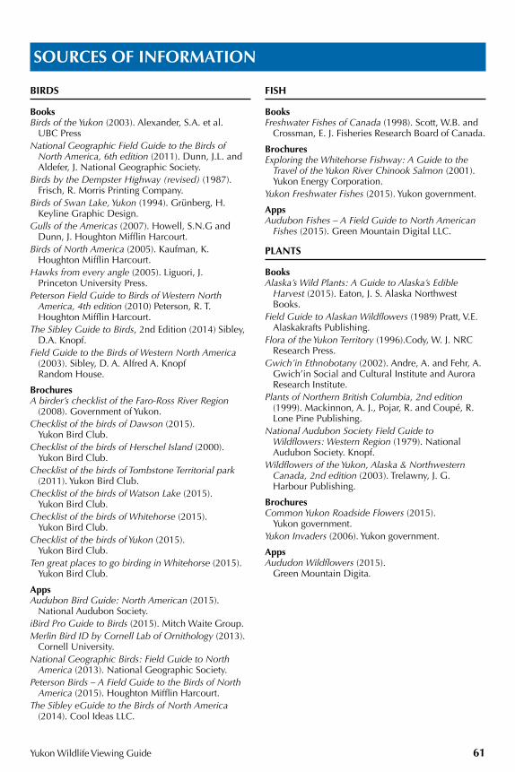
Yukon Wildlife Viewing Guide 61
BIRDS
BooksBirds of the Yukon (2003). Alexander, S.A. et al.
UBC PressNational Geographic Field Guide to the Birds of
North America, 6th edition (2011). Dunn, J.L. and Aldefer, J. National Geographic Society.
Birds by the Dempster Highway (revised) (1987). Frisch, R. Morris Printing Company.
Birds of Swan Lake, Yukon (1994). Grünberg, H. Keyline Graphic Design.
Gulls of the Americas (2007). Howell, S.N.G and Dunn, J. Houghton Mifflin Harcourt.
Birds of North America (2005). Kaufman, K. Houghton Mifflin Harcourt.
Hawks from every angle (2005). Liguori, J. Princeton University Press.
Peterson Field Guide to Birds of Western North America, 4th edition (2010) Peterson, R. T. Houghton Mifflin Harcourt.
The Sibley Guide to Birds, 2nd Edition (2014) Sibley, D.A. Knopf.
Field Guide to the Birds of Western North America (2003). Sibley, D. A. Alfred A. Knopf Random House.
BrochuresA birder’s checklist of the Faro-Ross River Region
(2008). Government of Yukon.Checklist of the birds of Dawson (2015).
Yukon Bird Club. Checklist of the birds of Herschel Island (2000).
Yukon Bird Club. Checklist of the birds of Tombstone Territorial park
(2011). Yukon Bird Club.Checklist of the birds of Watson Lake (2015).
Yukon Bird Club.Checklist of the birds of Whitehorse (2015).
Yukon Bird Club.Checklist of the birds of Yukon (2015).
Yukon Bird Club. Ten great places to go birding in Whitehorse (2015).
Yukon Bird Club.
AppsAudubon Bird Guide: North American (2015).
National Audubon Society. iBird Pro Guide to Birds (2015). Mitch Waite Group.Merlin Bird ID by Cornell Lab of Ornithology (2013).
Cornell University. National Geographic Birds: Field Guide to North
America (2013). National Geographic Society.Peterson Birds – A Field Guide to the Birds of North
America (2015). Houghton Mifflin Harcourt.The Sibley eGuide to the Birds of North America
(2014). Cool Ideas LLC.
FISH
BooksFreshwater Fishes of Canada (1998). Scott, W.B. and
Crossman, E. J. Fisheries Research Board of Canada.
BrochuresExploring the Whitehorse Fishway: A Guide to the
Travel of the Yukon River Chinook Salmon (2001). Yukon Energy Corporation.
Yukon Freshwater Fishes (2015). Yukon government.
AppsAudubon Fishes – A Field Guide to North American
Fishes (2015). Green Mountain Digital LLC.
PLANTS
BooksAlaska’s Wild Plants: A Guide to Alaska’s Edible
Harvest (2015). Eaton, J. S. Alaska Northwest Books.
Field Guide to Alaskan Wildflowers (1989) Pratt, V.E. Alaskakrafts Publishing.
Flora of the Yukon Territory (1996).Cody, W. J. NRC Research Press.
Gwich’in Ethnobotany (2002). Andre, A. and Fehr, A. Gwich’in Social and Cultural Institute and Aurora Research Institute.
Plants of Northern British Columbia, 2nd edition (1999). Mackinnon, A. J., Pojar, R. and Coupé, R. Lone Pine Publishing.
National Audubon Society Field Guide to Wildflowers: Western Region (1979). National Audubon Society. Knopf.
Wildflowers of the Yukon, Alaska & Northwestern Canada, 2nd edition (2003). Trelawny, J. G. Harbour Publishing.
BrochuresCommon Yukon Roadside Flowers (2015).
Yukon government. Yukon Invaders (2006). Yukon government.
AppsAududon Wildflowers (2015).
Green Mountain Digita.
SOURCES OF INFORMATION
Yukon Wildlife Viewing Guide62
Sources of information
EXPLORING AND WILDLIFE VIEWING
BooksA Naturalists Guide to the Arctic (1995). Pielou, E.C.
University of Chicago Press.Kluane National Park Hiking Guide 3rd edition
(2007). Lougheed, V. New Star Books.The New B.C. Roadside Naturalist (2013). Cannings,
R. and Cannings, S. Greystone Books Ltd.The Yukon Hiking Guide (1999). Vos, C. Borealis Books.Whitehorse & Area Hikes & Bikes, revised, (2005).
Yukon Conservation Society, Harbour Publishing. Yukon’s Tombstone and Blackstone Uplands: A
traveller’s guide. (2000) Locke, S. Canadian Parks and Wilderness Society.
BrochuresDriving the Fire Belt: North Klondike Highway
(2010). Yukon government. Into the Yukon Wilderness (2013). Yukon government.Viewing wildlife in Faro (2011). Yukon government. Viewing wildlife in Watson Lake (2016).
Yukon government. Whitehorse mountain bike and recreational trails,
1st Edition (2008). Gowdie, P.Wildlife in Whitehorse: A Guide to our Natural Areas
(2014). Yukon government.
Digital mediaWhitehorse Recreational Trail Guide (2015) Tarius Design.www.yukonhiking.com
MAMMALS
BooksA Field Guide to Animal Tracks (2005). Murie, O.J.
and Elbroch, M. Houghton Mifflin Harcourt.Hoofed mammals of British Columbia (2013).
Shackleton, D. Royal British Columbia Museum.Mammals of British Columbia (2001). Eder. T. Lone
Pine Publishing.Peterson Field Guide to Mammals, 4th edition.
(2006). Reid, F. Houghton Mifflin Harcourt.Tracking and the Art of Seeing: How to Read Animal
Tracks and Sign (1999). Rezendes, P. Collins Reference.
BrochuresHow you can stay safe in bear country (2013).
Yukon government.Yukon Bats (2014). Yukon government.Yukon Ungulates (2016). Yukon government.
Digital mediaAudubon Mammals – A Field guide to North
American Mammals. (2015) Green Mountain Digital LLC.
Staying Safe in Bear Country, Safety in Bear Country Society and International Association for Bear Research and Management (IBA), available www.macecanada.com/canada/product/video2.htm.
Yukon Mammals (2016). www.env.gov.yk.ca/mammals
INSECTS
BooksA Field Guide to the Insects: America North of
Mexico (1998). White, R.E., Borror, and D. J. Peterson, R.T. Houghton Mifflin Harcourt.
Bugs of Alberta (2000). Acorn, J. Lone Pine Publishing
Bugs of British Columbia (2001). Acorn, J. Lone Pine Publishing.
Butterflies of British Columbia (2001). Guppy, C. Shepard, J. UBC Press.
Introducing Dragonflies of British Columbia and the Yukon (2010). Cannings, R. A. Royal British Columbia Museum.
Insects of the Yukon (1997). Danks, H.V. and Downes J.A. Biological Survey of Canada.
Insects of South-Central Alaska (2008). Collet, D. M. Kenai Watershed Forum.
BrochuresYukon Butterflies (2014). Yukon government.
AppsAudubon Butterflies – A Field Guide to North
American Butterflies (2015). Green Mountain Digital LLC.
Audubon Insects and Spiders – A Field Guide to North American Insects and Spiders (2015). Green Mountain Digital LLC.
MUSHROOMS
BooksAll that the rain promises and more…(1991). Arora,
D. Ten Speed Press.Common Mushrooms of the Northwest (2006). Sept,
J. D. Calypso Publishing. Mushrooms and other fungi (2010). Phillips, R. Firefly
Books Ltd. Mushrooms of the Boreal Forest (1997) Bossenmaier,
E.F. University Extension Press.Mushrooms demystified (1986). Arora, D. Ten
Speed Press.
BrochuresCommon Yukon Mushrooms (2014). Yukon
government.Morel Mushroom Harvesting in Yukon.
Yukon government.Mushrooms of the National Forests in Alaska (2013).
United States Department of Agriculture.
Yukon Wildlife Viewing Guide 63
BIRDS (in taxonomic order)
• WATERBIRDS
Loon, Red-throated , Wildlife Info 7, 14Blackstone Uplands 48
Loon, Pacific Wildlife Info 7
Loon, Common Wildlife Info 7Watson Lake 42Simpson Lake (north end) 42Little Salmon Lake Campground
46Chapman Lake 49
Loon, Yellow-billed Wildlife Info 7
Grebe, Horned Meadow Lake 37,
Grebe, Red-necked Wye Lake Trail 18Target Lake 42
Cormorant, Double-crested Lake Laberge Campground 34
Swans Wildlife Info 10Nisutlin Delta National Wildlife
Area 20Johnsons Crossing – Teslin River
21Swan Lake, BC 20Swan Haven, M’Clintock Bay 22Aishihik Lake Campground 28Sulphur Lake 29Duke Meadows 30Swan Lake 31Shallow Bay, Lake Laberge 34Nordenskiold Habitat Protection
Area 35Klukshu Wetland overlook 40Na¬asìn River (Nisutlin River) 54Tagish Bridge Recreation Site 57
Goose, White-fronted Nisutlin Delta National Wildlife
Area 20
Goose, Canada Nisutlin Delta National Wildlife
Area 20
Eider, Common Herschel Island-Qikiqtaruk
Territorial Park 53Ivvavik National Park 53
Scoter, Black Gravel Lake 38
Duck, Harlequin Annie Lake Road 33Two Moose Lake 49
Duck, Long-tailed Blackstone Uplands 48
Goldeneye, Common and Barrow’s McIntyre Marsh 26
Merganser, Red-breasted Photo 43
Bufflehead
Duck, Ruddy Nordenskiold Habitat Protection
Area 35Gravel Lake 38
• RAPTORS
Osprey Squanga Lake 21Watson Lake 42Snafu Lake 56
Northern Harrier Wildlife Info (Hawks) 7Shallow Bay, Lake Laberge 34
Eagle, Bald Wildlife Info 6Photo 18Yukon River 24Sulphur Lake 29Kluane River overlook 30Watson Lake 42Na¬asìn River (Nisutlin River) 54Tagish Bridge Recreation Site 57
Eagle, Golden Wildlife Info 6Fish and Jackson lakes 26Annie Lake Road 33Angelcomb Peak 48Blackstone Uplands 48Engineer Creek Campground 51
Goshawk, Northern Wildlife Info 8
Hawk, Red-tailed Wildlife Info (Hawks) 7Photo 41
Hawk, Rough-legged Wildlife Info (Hawks) 7Herschel Island-Qikiqtaruk
Territorial Park 53
Kestrel, American Wildlife Info (Falcons) 6
INDEX: SPECIES WITH LOCATIONS
This is a partial list of Yukon wildlife and where to look for them. The symbols indicate in which habitat that animal can be found. In some cases, a species of animal might occur all over Yukon, so individual locations are not specifically listed. Instead, read up about their habitat in order to know where to look for them. Sometimes there are specific nesting sites or key locations where an animal is likely to be found; these sites are listed below the species. Bold numbers indicate there is a photograph on that page.
Habitat symbolsBoreal forest, p.11
South-facing slopes, p.12
Mountain, p.13
Arctic tundra, p.13
Still water, p.14
Flowing water, p.15
Marine and coastal, p.15
Yukon Wildlife Viewing Guide64
Index: Species with locations
Merlin Wildlife Info 6
Falcon, Peregrine Wildlife Info 6Yukon River 24Swan Lake 31Engineer Creek Campground 51Herschel Island-Qikiqtaruk
Territorial Park 53Yukon River Campground 58
Gyrfalcon Wildlife Info 6Fish and Jackson lakes 26Annie Lake Road 33Gyrfalcon nest 50Engineer Creek Campground 51
• GROUSE-LIKE BIRDS
Grouse, Sharp-tailed Duke Meadows 30Gravel Lake 38Dempster Highway 47
Grouse, Spruce
Ptarmigan Wildlife Info 9Fish and Jackson lakes 26Annie Lake Road 33Blackstone Uplands 48
• CRANE-LIKE BIRDS
Sora Nordenskiold Habitat Protection
Area 35
Coot, American Tthe Ndu Lake 36Meadow Lake 37
Crane, Sandhill Tthe Ndu Lake 36Tintina Trench viewpoint 38Fingers Site 45
• SHOREBIRDS
Plover, American Golden Fish and Jackson lakes 26Blackstone Uplands 48
Yellowlegs, Lesser Fish and Jackson lakes 26Fox Lake 34
Tattler, Wandering Windy Pass 50
Sandpiper, Spotted
Sandpiper, Upland Takhini Burn 27Duke Meadows 30
Whimbrel Blackstone Uplands 48
Phalarope, Red-necked Two Moose Lake 49
• GULL-LIKE BIRDS
Jaeger, Pomarine Wildlife Info 7
Jaeger, Parasitic Wildlife Info 7
Jaeger, Long-tailed Wildlife Info 7Blackstone Uplands 48Ivvavik National Park 53
Gull, Bonaparte’s Kookatsoon Lake Recreation Site
33
Gull, Mew Quartz Road Wetland Interpretive
Trail 25
Gull, Herring Quartz Road Wetland Interpretive
Trail 25
Gull, Glaucous Ivvavik National Park 53
Tern, Arctic Lapie Lakes 55
• SEABIRDS
Guillemot, Black Herschel Island-Qikiqtaruk
Territorial Park 53
• OWLS
Wildlife Info 8
Owl, Great Horned
Owl, Great Gray
Owl, Snowy Rock River Campground 52
Owl, Northern Hawk Takhini Burn 27Snag Junction Campground 31
Owl, Short-eared Shallow Bay, Lake Laberge 34Blackstone Uplands 48Arctic Circle 51
Owl, Boreal
• KINGFISHERS
Kingfisher, Belted Miles Canyon 23
• WOODPECKERS
Woodpecker, Three-toed
Woodpecker, Pileated Wye Lake Trail 18
• PERCHING BIRDS
Shrike, Northern Wildlife Info 8Photo 31
Vireo, Blue-headed Albert Creek Bird Observatory 18
Lark, Horned
Raven, Common Wildlife Info 9Lapie River Campground 43Fingers Site 45
SwallowsWildlife Info 10
Swallow, Tree , Wye Lake Trail 18McIntyre Marsh 26
Swallow, Violet-green Wye Lake Trail 18Miles Canyon 23
Swallow, Bank Miles Canyon 23Bank Swallows 59Stewart River Lookout 59
Habitat symbolsBoreal forest, p.11
South-facing slopes, p.12
Mountain, p.13
Arctic tundra, p.13
Still water, p.14
Flowing water, p.15
Marine and coastal, p.15
Yukon Wildlife Viewing Guide
Index: Species with locations
65
Swallow, Cliff Johnsons Crossing – Teslin River
21Jakes Corner 22, 22Miles Canyon 23
Chickadee, Boreal McIntyre Marsh 26
Dipper, American Rancheria Falls Recreation Site 19Otter Falls 28
Kinglet, Ruby-crowned
Bluethroat
Wheatear, Northern Wildlife Info 8Rock River Campground 52
Thrush, Grey-cheeked Two Moose Lake 49
Thrush, Swainson’s
Thrush, Varied
Pipit, American Two Moose Lake 49
Waterthrush, Northern Moose Creek Campground 38
Warbler, Tennessee Quiet Lake Campground 54
Warbler, Yellow
Yellowthroat, Common Yukon College Boreal Worlds
Trail 26Moose Creek Campground 38
Warbler, Wilson’s Moose Creek Campground 38
Sparrow, American Tree Five Finger Rapid Recreation Site
35
Sparrow, Clay-colouredWye Lake Trail 18
Sparrow, SavannahLapie Lakes 55, 55
Sparrow, SwampWye Lake Trail 18
Sparrow, White-throatedWye Lake Trail 18Albert Creek Bird Observatory 18
Sparrow, White-crowned Five Finger Rapid Recreation Site
35
Junco, Slate-coloured
Bunting, Snow Blackstone Uplands 48
Longspur, Lapland Blackstone Uplands 48
Longspur, Smith’s Arctic Circle 51
Blackbird, Red-winged Nordenskiold Habitat Protection
Area 35
Blackbird, Rusty Yukon College Boreal Worlds
Trail 26
Crossbill, Red Wildlife Info 6
Crossbill, White-winged Wildlife Info 6
Redpoll, Common and Hoary
Blackstone Uplands 48
MAMMALS
Bat, Little Brown Hidden Lakes 25Chadburn Lake Recreation Area
25
Bear, Black Wildlife Info 5Yukon River 24Pine Lake Campground 28Kluane National Park & Reserve
29Haines Road 40Na¬asìn River (Nisutlin River) 54Photo 56
Bear, Grizzly Wildlife Info 5Kusawa Lake Campground 27Congdon Creek Campground
(KhaÖr Sha/n Nji) 30Kluane River overlook 30Elk and bear viewing 35Dalton Post 40Klukshu River 41Photo 41Chapman Lake 49Arctic Circle 51Ivvavik National Park 53
Ni’iinlii Njik (Fishing Branch) Territorial Park 53
Na¬asìn River (Nisutlin River) 54
Bear, Polar Wildlife Info 5
Beaver, American Wildlife Info 5Millennium Trail and Bert Law
Park 24Hidden Lakes 25Yukon College Boreal Worlds
Trail 26McIntyre Marsh 26Nordenskiold Habitat Protection
Area 35Na¬asìn River (Nisutlin River) 54Snafu Lake 56Tagish Bridge Recreation Site 57
Bison, Wood Wildlife Info 10Aishihik Lake Campground 28
Caribou Photo 2Wildlife Info 5Little Rancheria 19Jakes Corner 22Finlayson Lake 43Blackstone Uplands 48Chapman Lake 49Windy Pass 50Arctic Circle 51Herschel Island-Qikiqtaruk
Territorial Park 53Ivvavik National Park 53Top of the World Highway 58Fortymile Caribou range 57
Chipmunk, Least Rancheria Falls Recreation Site 19
CougarWildlife Info 5
Coyote Wildlife Info 5Photo 6Millennium Trail and Bert Law
Park 24Quiet Lake Campground 54
Deer, Mule Wildlife Info 6Photo 7Millennium Trail and Bert Law
Park 24Takhini Burn 27Tatchun/Frenchman Road 36Tarfu Lake 56Five Mile Lakes Campground 60
Yukon Wildlife Viewing Guide66
Index: Species with locations
Elk Wildlife Info 6Elk viewing 27Takhini Burn 27Elk and bear viewing 35
Ermine (Weasel)
Fox, Arctic
Fox, Red Swan Lake 31Nordenskiold Habitat Protection
Area 35Blackstone Uplands 48Top of the World Highway 58
Goat, Mountain Wildlife Info 8Yukon/BC border 32White Mountain 56
Hare, Snowshoe Wildlife Info 9Photo 57
Lynx, Canada Wildlife Info 8Yukon Wildlife Preserve 34Photo 57
Marmot, Hoary Wildlife Info 7Angelcomb Peak 48Signpost Hill, Keno City 60
Marten, Pine Wildlife Info 9
Mink Nordenskiold Habitat Protection
Area 35Quiet Lake Campground 54
Moose Wildlife Info 8Photo 11Yukon River 24Aishihik Lake Campground 28Photo 31Nordenskiold Habitat Protection
Area 35Ethel Lake Campground 37Dezadeash River Trail 41Target Lake 42Simpson Lake (north end) 42Two Moose Lake 49Na¬asìn River (Nisutlin River) 54Quiet Lake Campground 54Lapie Lakes 55Moose Calving Key Habitat Area
59Devils Elbow Wetland 59Stewart River Lookout 59
Muskox Ivvavik National Park 53
Muskrat Yukon College Boreal Worlds
Trail 26McIntyre Marsh 26Pickhandle Lake 30Swan Lake 31Fox Lake 34Nordenskiold Habitat Protection
Area 35
Otter, River Photo 15McIntyre Marsh 26
Pika, Collared Wildlife Info 5Angelcomb Peak 48Signpost Hill, Keno City 60
Porcupine Photo 54
Seals Herschel Island-Qikiqtaruk
Territorial Park 53
Sheep, Dall’s Wildlife Info 9Conrad Campground 32Yukon Wildlife Preserve 34Kusawa Lake Campground 27TachaÖl Dha/l (Sheep Mountain)
Visitor Information Centre 29Yukon/BC border 32Annie Lake Road 33Angelcomb Peak 48Sheep lick and trails 50Engineer Creek Sheep Lick 50
Sheep, Fannin’s Wildlife Info 9Ddhaw Ghro Habitat Protection
Area 37Faro viewing sites 44, 45
Sheep, Stone’s Wildlife Info 9Lapie River Crossing #2 55
Squirrel, Arctic Ground Wildlife Info 5Jakes Corner 22Kusawa Lake Campground 27Tagish Bridge Recreation Site 57Photo 57
Squirrel, Red Wildlife Info 9
Whales Herschel Island-Qikiqtaruk
Territorial Park 53
Wolf, Grey Wildlife Info 10Aishihik Lake Campground 28Sulphur Lake 29Chapman Lake 49Na¬asìn River (Nisutlin River) 54Top of the World Highway 58
Wolverine Wildlife Info 10
FISHSee Yukon Freshwater Fishes
brochure 17
FROG, WOODSee Yukon Amphibians brochure
Habitat symbolsBoreal forest, p.11
South-facing slopes, p.12
Mountain, p.13
Arctic tundra, p.13
Still water, p.14
Flowing water, p.15
Marine and coastal, p.15
Yukon Wildlife Viewing Guide 67
AAishihik Lake Campground 28Alaska Highway 18-31Albert Creek Bird Observatory 18Angelcomb Peak 48Annie Lake Road 33Arctic Circle 51Atlin Road 56
BB.C./Yukon border 32Bank Swallows 59Beaver Creek 31Bert Law Park 24Binet House, Mayo 59Blackstone River Rest Area 41Blackstone Uplands 48Bruce Lake 43
CCampbell Region Interpretive
Centre 44Canyon Creek 28Carcross Desert viewpoint 32Chadburn Lake Recreation Area 25Chapman Lake 49Coffee Lake 43Congdon Creek Campground
(KhaÖr Shän Nji) 30Continental Divide 19Conrad Campground 32Crocus Bluff Trail 39
DDa Ku Cultural Centre 29Dalton Post 40Ddhaw Ghro Habitat Protection
Area 37Deadman Creek 21Dempster Highway 47-53Dempster Highway Information
47Devils Elbow Wetland 59Dezadeash River Trail 41Drunken forest 37Drury Creek Campground 46Duke Meadows 30
EEmerald Lake 33Engineer Creek Campground 51Engineer Creek sheep lick 50Ethel Lake Campground 37
FFaro Arboretum 45Fingers Site 45Finlayson Lake 43Fish Lake 26Fisheye Lake 46Five Finger Rapids Recreation
Site 35Five Mile Lake Campground 60Fortymile Caribou range 57Fox Lake 34Fox Lake Burn 35Frances Lake Campground 43
GGravel Lake 38Gunnar Nilsson Mickey Lammers
Research Forest 34Gyrfalcon nest 50
HHaines Road 40-41Herschel Island-Qikiqtaruk
Territorial Park 53Hidden Lakes 25Highway #1 18-31Highway #2 32-33Highway #2 34-39Highway #3 40-41Highway #4 42-46Highway #5 47-53Highway #6 54-55Highway #7 56Highway #8 57Highway #9 58Highway #11 59-60
IIvvavik National Park 53
JJackson Lake 26Jakes Corner 22Johnson Lake Campground 44Johnsons Crossing – Teslin River
21
KKathleen River bridge 41Klondike River 39Klondike River Campground 39Kluane National Park & Reserve
29
Kluane River overlook 30Klukshu River 41Klukshu Wetland overlook 40Kookatsoon Lake Recreation Site
33Kusawa Lake Campground 27Kusawa Lake Road 27
LLake Laberge Campground 34Lapie Lakes 55Lapie River Campground 43Lapie River Crossing #2 55Liard Canyon - Lucky Lake
Recreation Site 18Little Rancheria Caribou Herd 19Little Salmon Lake Campground
46Little Salmon Lake Slides 46Long Lake 25Łútsäw Wetland Habitat
Protection Area 36
MMarsh Lake Campground and
Recreation site 22McIntyre Marsh 26Meadow Lake 37Miles Canyon 23Millennium Trail 24Million Dollar Falls Campground 40Minto Creek Bridge 60Moose Calving Key Habitat Area
59Moose Creek Campground 38Mount Haldane 60Mount McIntyre Ski Trails 26Mount Mye Sheep Centre 45
NNa¬asìn River River (Nisutlin River)
54Ni’iinlii Njik (Fishing Branch)
Territorial Park 53Nisutlin Delta National Wildlife
Area 20Nordenskiold Habitat Protection
Area 35North Canol Road 55North Fork Pass Summit 48North Klondike Highway 34-39
INDEX: WILDLIFE VIEWING SITES
This is an alphabetical list of all the sites mentioned in this guide with a reference to the page number where you will find more information.
Yukon Wildlife Viewing Guide68
Index: Wildlife Viewing Sites
OOgilvie Ridge/Gwazhal Kak 51Old Crow Flats (Van Tat
K’atr’anahtii) 53Old Crow Flats Special
Management Area 53Orchid Acres 58Otter Falls 28
PPickhandle Lake 30Pine Lake Campground 28
QQuartz Road Wetland Interpretive
Trail 25Quiet Lake Campground 54Quiet Lake Recreation Site 54
RRancheria Falls Recreation Site 19Red Creek 50Robert Campbell Highway 42-46Rock River Campground 52
SShallow Bay, Lake Laberge 34Sheep Mineral Lick 45Sheep Mountain Viewing Platform
45Signpost Hill, Keno City 60Silver Trail 59-60Simpson Lake (north end) 42Snafu Lake Campground 56Snag Junction Campground 31
South Canol Road 54-55South Klondike Highway 31-33Spruce Beetle Interpretive Trail 29Squanga Lake Campground 21Stewart River Lookout 59Sulphur Lake 29Sulphur Springs 50Swan Haven, M’Clintock Bay 22Swan Lake, BC 20Swan Lake 31
TTachaÖl Dhäl (Sheep Mountain)
Visitor Information Centre 29Tagé-Cho-Hudän Interpretive
Centre, Carmacks 35Tagish Bridge Recreation Site
and Tagish Narrows Habitat Protection Area 57
Tagish Road 56Takhini Burn 27Takhini Salt Flats 27Tarfu Lake Campground 56Target Lake 42Tatchun/Frenchman Road 36Tatshenshini River viewpoint 40Teslin Lake Campground and Bird
Observatory 21Teslin Lake Interpretive Site 20The Last Pine 28Tintina Trench viewpoint 38Tom Creek Wetland 42Tombstone Park Interpretive
Centre 47Tombstone Territorial Park 47Tombstone Range Viewpoint 48
Top of the World Highway 58Town of Faro, Mitchell Road
intersection 44Tthe Ndu Lake 36Two Moose Lake 49
VVan Gorder Falls Trail, downtown
Faro 44Vuntut National Park 53
WWareham Lake 60Watson Lake 42White Mountain 56Whitehorse Rapids and
Fish Ladder 24Windy Pass 50Wolf Creek Campground 23Wolf River 20Wye Lake Trail 18
YYukon College Boreal Worlds
Trail 26Yukon River 24Yukon River Bridge 22Yukon River Campground 58Yukon Wildlife Preserve 34Yukon/BC border 32Yukon/Northwest Territories
border 52
Spring caribou viewing by snowmobile, Yukon government
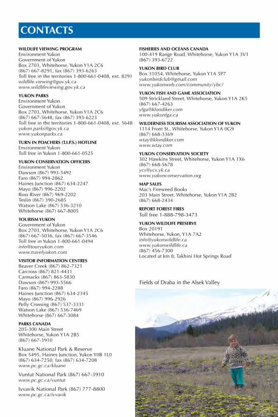
CONTACTS
WILDLIFE VIEWING PROGRAMEnvironment YukonGovernment of YukonBox 2703, Whitehorse, Yukon Y1A 2C6(867) 667-8291, fax (867) 393-6263Toll free in the territories 1-800-661-0408, ext. [email protected]
YUKON PARKSEnvironment YukonGovernment of YukonBox 2703, Whitehorse, Yukon Y1A 2C6(867) 667-5648, fax (867) 393-6223Toll free in the territories 1-800-661-0408, ext. [email protected]
TURN IN POACHERS (T.I.P.S.) HOTLINEEnvironment YukonToll free in Yukon 1-800-661-0525
YUKON CONSERVATION OFFICERSEnvironment YukonDawson (867) 993-5492Faro (867) 994-2862Haines Junction (867) 634-2247Mayo (867) 996-2202Ross River (867) 969-2202Teslin (867) 390-2685Watson Lake (867) 536-3210Whitehorse (867) 667-8005
TOURISM YUKONGovernment of YukonBox 2703, Whitehorse, Yukon Y1A 2C6(867) 667-5036, fax (867) 667-3546Toll free in Yukon [email protected]
VISITOR INFORMATION CENTRESBeaver Creek (867) 862-7321Carcross (867) 821-4431Carmacks (867) 863-5830Dawson (867) 993-5566Faro (867) 994-2288Haines Junction (867) 634-2345Mayo (867) 996-2926Pelly Crossing (867) 537-3331Watson Lake (867) 536-7469Whitehorse (867) 667-3084
PARKS CANADA205-300 Main Street Whitehorse, Yukon Y1A 2B5(867) 667-3910
Kluane National Park & ReserveBox 5495, Haines Junction, Yukon Y0B 1L0(867) 634-7250, fax (867) 634-7208www.pc.gc.ca/kluane
Vuntut National Park (867) 667-3910www.pc.gc.ca/vuntut
Ivvavik National Park (867) 777-8800www.pc.gc.ca/ivvavik
FISHERIES AND OCEANS CANADA100-419 Range Road, Whitehorse, Yukon Y1A 3V1(867) 393-6722
YUKON BIRD CLUBBox 31054, Whitehorse, Yukon Y1A [email protected]/community/ybc/
YUKON FISH AND GAME ASSOCIATION509 Strickland Street, Whitehorse, Yukon Y1A 2K5(867) [email protected] www.yukonfga.ca
WILDERNESS TOURISM ASSOCIATION OF YUKON1114 Front St., Whitehorse, Yukon Y1A 0G9(867) [email protected] www.wtay.com
YUKON CONSERVATION SOCIETY302 Hawkins Street, Whitehorse, Yukon Y1A 1X6(867) [email protected]
MAP SALESMac’s Fireweed Books203 Main Street, Whitehorse, Yukon Y1A 2B2(867) 668-2434
REPORT FOREST FIRESToll free 1-888-798-3473
YUKON WILDLIFE PRESERVEBox 20191Whitehorse, Yukon, Y1A [email protected](867) 456-7300Located at km 8, Takhini Hot Springs Road
Fields of Draba in the Alsek Valley
You can get more inform
ation about w
ildlife viewing, backcountry travel
and events from W
ild Discoveries and
Into the Yukon Wilderness.
P.O. B
ox 2703 W
hitehorse, Yukon Y1A 2C
6
V5N
Current events are alw
ays listed on our w
ebsite.
ww
w.w
ildlifeviewing.gov.yk.ca
ISBN
978-1-55362-739-5U
pdated February 2016Finished w
ith your copy? Pass it on.
Available for
free distribution


![Cariboo Region - British Columbia · of wildlife species as habitats change. [Remote Wildlife Viewing Sites] Some sites in the Cariboo Region offering wildlife viewing in remote settings](https://img.pdfslide.us/doc/110x75/5eda3de6b3745412b57102e8/cariboo-region-british-of-wildlife-species-as-habitats-change-remote-wildlife.jpg)