Embed Size (px)
Citation preview
_______________________________________________
Wildland Fire Weather:
Multi-Agency Portfolio of Current and In-development Capabilities to Support User Needs
FCM-R34-2011
Office of the Federal Coordinator for Meteorological Services and Supporting Research
May 2011
THE INTERDEPARTMENTAL COMMITTEE FOR METEOROLOGICAL SERVICES
AND SUPPORTING RESEARCH (ICMSSR)
MR. SAMUEL P. WILLIAMSON, CHAIRMANFederal Coordinator MR. THOMAS PUTERBAUGH Department of Agriculture DR. JOHN (JACK) L. HAYES Department of Commerce RADM DAVID TITLEY, USN United States Navy Department of Defense DR. FRED P. LEWIS United States Air Force Department of Defense MR. RICKEY PETTY Department of Energy MR. JOE WALL (ACTING) Science and Technology Directorate Department of Homeland Security MR. JOHN VIMONT Department of the Interior MR. MARK KEHRLI Federal Highway Administration Department of Transportation
MR. PAUL FONTAINE (ACTING) Federal Aviation Administration Department of Transportation DR. JONATHAN M. BERKSON United States Coast Guard Department of Homeland Security DR. DAVID LEA Department of State DR. S. T. RAO Environmental Protection Agency MR. PATRICK HERNANDEZ (ACTING) Federal Emergency Management Agency Department of Homeland Security DR. RAMESH KAKAR National Aeronautics and Space Administration DR. MICHAEL MORGAN National Science Foundation MR. DONALD E. EICK National Transportation Safety Board MS. JENNIFER UHLE (ACTING) U.S. Nuclear Regulatory Commission
MR. MICHAEL BABCOCK, Secretariat
Office of the Federal Coordinator for Meteorological Services and Supporting Research
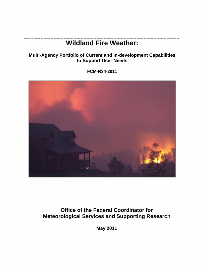
Cover Image Several homes in the wildland‐urban interface are threatened by wildland fire. Credit: NIFC
FEDERAL COORDINATOR
FOR
METEOROLOGICAL SERVICES AND SUPPORTING RESEARCH
8455 Colesville Road, Suite 1500 Silver Spring, Maryland 20910
301-427-2002 www.ofcm.gov
Wildland Fire Weather: Multi-Agency Portfolio of Current and In-development
Capabilities to Support User Needs
FCM-R34-2011 Washington, D.C. May 2011

Wildland Fire Weather: Multi-Agency Capabilities Portfolio
iii
Foreword
In June 2007, the Office of the Federal Coordinator for Meteorology (OFCM) released the report, National Wildland Fire Weather: A Summary of User Needs and Issues, which was developed by the Office of the Federal Coordinator for Meteorology (OFCM)-sponsored Joint Action Group for National Wildland Fire Weather Needs Assessment (JAG/NWFWNA). While the 2007 groundbreaking report documented user needs and issues, this report relates current and in-development capabilities to the user needs in each of the nine Functional Areas assessed during the NWFWNA. Additional details regarding the background and process for the capabilities assessment are contained in the Executive Summary and Chapter 1 of this report. The OFCM staff, with substantial aid from members of the original JAG/NWFWNA and others in the wildland fire management community, has assembled this portfolio of approximately 78 distinct current and in-development capabilities. The report validates that multiple agencies and stakeholders are working on numerous capabilities against a common baseline of user needs. It should be emphasized that this report is meant to be a living document, with periodic updates at least every 3 years. Embedded within Chapter 2 of the report are important activities that are being coordinated within the OFCM infrastructure which will contribute to improving meteorological observations and services related to wildland fires.
- One of these activities is the Multifunction Phased Array Radar (MPAR). Phased array radar (PAR) is a proven technology employing electronically steered radar beams to enhance the flexibility of radar systems while reducing logistics costs by eliminating moving parts. PARs are characterized by fixed, flat faces comprising numerous individual transmit/receive (T/R) modules which, when activated in designed sequences, produce a beam that can be steered by shifting the phase relationships of the transmissions from the T/R units. The MPAR initiative is exploring the employment of a PAR to simultaneously address a combination of requirements for several missions using the same radar platform. Those missions include standard weather applications (severe weather, hydrology, etc.), air terminal weather applications (downburst, wind shear), air traffic management, and defense and homeland security. Other potential enhanced applications include bird hazard detection and detection and wind field determination support for wildland fires, volcanic ash, and accidental and terrorist nuclear, biological, chemical events.
- The OFCM, through its Committee for Integrated Observing Systems (CIOS), is working with the federal agencies to establish the Network of Weather and Climate Observing Networks (NOWCON). The goal of the NOWCON is to develop a federal strategy to integrate disparate observing systems to meet multiple national needs in a cost-effective manner and to provide an organizational framework for coordination, integration and interoperability. The interagency Remote Automated Weather Station (RAWS) network is one of the set of observing networks being considered by the CIOS as it works toward implementing the NOWCON.
An additional area of extreme importance regarding the improvement of meteorological services related to wildland fires is the incorporation of social science results into meteorological operations. As discussed in Chapter 10, the OFCM is also engaged in this area and, after hosting an Exploratory
iv
Mini-Workshop on May 3-4, 2010, published the report, Framing the Questions – Addressing the Needs: Moving to Incorporate Social Science Results into Meteorological Operations/Services. This is a very important area which the meteorological and wildland fire communities will reap benefits in the future.
I want to express my deepest gratitude for the hard work and long hours expended by my staff and the subject matter experts that provided input to this report.
//SIGNED// Samuel P. Williamson Federal Coordinator for Meteorological Services and Supporting Research
Wildland Fire Weather: Multi-Agency Capabilities Portfolio
v
Contents Foreword ............................................................................................................................................. iii
Executive Summary .................................................................................................................... ES-1
1. Introduction ......................................................................................................................... 1-1
2. Functional Area 1: Data Collection, Integrity, Processing, and Archival ................... 2-1
3. Functional Area 2: Fire Weather Research and Development ..................................... 3-1
4. Functional Area 3: Forecast Products and Services ....................................................... 4-1
5. Functional Area 4: Modeling, Prediction, and Data Assimilation ................................ 5-1
6. Functional Area 5: Information Dissemination and Technologies ............................. 6-1
7. Functional Area 6: Education, Training, Outreach, Partnering, and Collaboration ................................................................................................................ 7-1
8. Functional Area 7: User Response, Decision Support, and Resulting User Impacts ........................................................................................................................ 8-1
9. Functional Area 8: Funding and Human Resources (Crosscutting) ............................ 9-1
10. Functional Area 9: Socioeconomic Factors ................................................................... 10-1
11. Improving Fire Weather Capabilities within the NWCG Structure .......................... 11-1
References ....................................................................................................................................... R-1
Appendices
A. Western Governors’ Association Policy Resolution 05-04
B. Summary of Recommendations from 2006 NOAA SAB Report, Conducted by Fire Weather Research Working Group
C. NOAA SAB Fire Weather Research Working Group Recommendations and Relevant NWFWNA User Needs
D. Capabilities Relevant to NWFWNA User Needs
Wildland Fire Weather: Multi-Agency Capabilities Portfolio
vi
Figures 1-1. Interagency Wildland Fire Governance Structure .......................................................... 1-2
1-2. National Wildfire Coordinating Group (NWCG) Executive Board... ........................ 1-3
1-3. NWCG Structure... ............................................................................................................. 1-3
6-1. Wildlandfire.com Web Page... ........................................................................................... 6-3
6-2. NIFC Web Page... ............................................................................................................... 6-4
Tables 1. Federal Agency Stakeholders in the Wildland Fire Weather Community .................. 1-9
2. Summary of Identified Wildland Fire Weather User Needs by Primary Functional Area ................................................................................................................. 1-10
3. NOAA FWRWG High Priority Recommendations and Relevant NWFWNA User Needs ......................................................................................................................... 1-22
4. Observational Data Element Needs Assessment ......................................................... 2-31
5. Research Topic Needs Assessment .................................................................................. 3-9
6. Products and Services Needs Assessment ..................................................................... 4-17
Wildland Fire Weather: Multi-Agency Capabilities Portfolio
vii
Acronym List 4D four-dimensional
ARL NOAA Air Resources Laboratory
ASCADS Automated Sorting, Conversion, and Distribution System
ASOS Automated Surface Observing Systems
AVHRR Advanced very high resolution radiometer
AWIPS Advanced weather information processing system
BIA Bureau of Indian Affairs [U.S. Dept of the Interior]
BLM Bureau of Land Management [U.S. Dept of the Interior]
Bluesky A modeling framework to predict cumulative impacts of smoke from agriculture, forest, and range fires
CANSAC California and Nevada Smoke and Air Committee
CCSM [NCAR] Community Climate System Model
CCSP U.S. Climate Change Science Program
CEFA Climate, Ecosystem and Fire Applications [program at DRI]
CESORN Committee for Environmental Services, Operations, and Research Needs
CIOS [OFCM]Committee for Integrated Observing Systems
COMET Cooperative Program for Operational Meteorology, Education and Training
CPC Climate Prediction Center [of NOAA/NWS/NCEP]
DRI Desert Research Institute
DTC Developmental Testbed Center
EAMC Eastern Area Modeling Consortium
EMC [NOAA/NCEP] Environmental Modeling Center
EMWIN [NOAA/NWS] Emergency Manager Weather Information Network
EPA U.S. Environmental Protection Agency
ERC Energy Release Component
ESRL/GSD Global Systems Division of the [NOAA] Environmental Systems Research Laboratory [formerly the Forecast Systems Laboratory]
FAMWEB Fire and aviation management web applications web site
FARSITE A fire behavior and growth simulator for use on Windows computers
FCAMMS Fire Consortia for the Advanced Modeling of Meteorology and Smoke
FCMSSR Federal Committee for Meteorological Services and Supporting Research
FDW FAMWEB Data Warehouse
FEC Fire Executive Council
FENC Fire Environment Committee [of NWCG]
FENWT Fire Environment Working Team [now FENC]
FHAES Fire History Analysis and Exploration System
FlamMap A fire behavior mapping and analysis application that computes potential fire behavior characteristics over an entire FARSITE landscape
FMS figure of merit in space
FOS [NOAA/NWS] Family of Services
FPA Fire Planning Analysis
Wildland Fire Weather: Multi-Agency Capabilities Portfolio
viii
FRAMES Fire Research and Management Exchange System
FRP fire radiative power
FSRSL Forest Service Remote Sensing Lab (at RMRS/RMC)
FWRWG Fire Weather Research Working Group [of NOAA/SAB]
FWS Fish and Wildlife Service [U.S. Dept of the Interior]
FX-NET NOAA’s Forecast System Laboratory weather forecasting workstation
GACC Geographic Area Coordination Center
GEO NSF Directorate of Geosciences
GEOSS Global Earth Observing System of Systems
GIS Geographical Information System
GOES Geostationary Operational Environmental Satellite
GOES/DCS GOES Data Collection System
HMS (NESDIS) Hazard Mapping System
HYPACT Hybrid Particle and Concentration Transport [model]
HYSPLIT Hybrid Single Particle Lagrangian Integrated Trajectory [model]
ICMSSR Interdepartmental Committee for Meteorological Services and Supporting Research
IEOS Integrated Earth Observation System
IFT-DSS Interagency Fuels Treatment Decision Support System
IMET Incident Meteorologist
IMT Incident Management Team
ISOS Integrated Surface Observing System
JAG Joint Action Group
JAG/NWFWNA Joint Action Group for National Wildland Fire Weather Needs Assessment
JFSP Joint Fire Science Program
KCFAST A web-based computer application that simplifies data retrieval from NIFMID
MADIS [NOAA] Meteorological Assimilation Data Ingest System
MASTER NASA MODIS/ASTER Airborne Simulator
MIC Meteorologist-in-Charge
MODIS [NASA] Moderate Resolution Imaging Spectroradiometer
MPAR Multifunction Phased Array Radar
MTDC Forest Service Missoula Technology Development Center
NAM North American Mesoscale [model]
NAWIPS An expanded version of AWIPS that supports additional graphical formats
NCAR National Center for Atmospheric Research
NCEP [NOAA] National Centers for Environmental Prediction
NDFD [NOAA/NWS] National Digital Forecast Database
NDVI Normalized difference vegetation index
NEPA National Environmental Policy Act
NESDIS National Environmental Satellite, Data, and Information Service
NEXRAD NWS Weather Radar WSR-88D
NFDRS National Fire Danger Rating System
NICC National Interagency Coordination Center [of the NIFC]
Wildland Fire Weather: Multi-Agency Capabilities Portfolio
ix
NIFC National Interagency Fire Center
NIFMID National Interagency Fire Management Integrated Database
NIMO National Incident Management Organization
NIST National Institute of Standards and Technology
NLDN National Lightning Detection Network
NMAC National Multi Agency Coordinating [group]
NOAA National Oceanic and Atmospheric Administration
NPOESS National Polar-orbiting Operational Environmental Satellite System
NPP NPOESS Preparatory Project
NPS National Park Service [U.S. Dept of the Interior]
NPSG National Predictive Services Group [now NPSS]
NPSS National Predictive Services Subcommittee [of NWCG/FENC]
NSF National Science Foundation
NWCG National Wildfire Coordinating Group
NWFEA National Wildland Fire Enterprise Architecture
NWFWNA National Wildland Fire Weather Needs Assessment
NWP numerical weather prediction
NWRMC Northwest Regional Modeling Consortium
NWS [NOAA] National Weather Service
NWSTG NWS Telecommunication Gateway
OFCM Office of the Federal Coordinator for Meteorological Services and Supporting Research
PAR phased array radar
PDA Personal Digital Assistant
PFM Point Forecast Matrix [NWS product]
PM Particulate matter size, in microns
R&D Research and Development
RACM Regional Atmospheric Chemistry Model
RAWS Remote Automated Weather Station
RERAP Rare event risk assessment process
RMC Rocky Mountain Center for Advanced Modeling of Meteorology and Smoke
RMRS Forest Service Rocky Mountain Research Station
ROMAN Real-time Observation Monitor and Analysis Network
RSAC [Forest Service] Remote Sensing Applications Center [in Salt Lake City, UT]
RSFWSU [NIFC] Remote Sensing/Fire Weather Support Unit
SAB [NOAA] Science Advisory Board
SBIR Small Business Innovative Research program
SDSMT South Dakota School of Mines and Technology
SEMIP Smoke and Emissions Modeling Intercomparison Project
SFS [NOAA] Smoke Forecasting System
SHRMC Southern High Resolution Modeling Center
SNOTEL Snowpack telemetry data
SPC Storm Prediction Center [of NOAA/NWS/NCEP]
Wildland Fire Weather: Multi-Agency Capabilities Portfolio
x
T/R transmit/receive
UAS unmanned aerial system
UAV unmanned aerial vehicle
UCAR University Corporation for Atmospheric Research
UCATS Unmanned aircraft systems Chromatograph for Atmospheric Trace Species [ESRL instrument flying on Altair UAS as part of WRAP]
USDA U.S. Department of Agriculture
USFS U.S. Forest Service
WFABBA Wildfire Automated Biomass Burning Algorithm
WFAS Wildland Fire Assessment System
WFDSS Wildland Fire Decision Support System
WFIP Wildland Fire Implementation Plan
WFLC Wildland Fire Leadership Council
WFMI Wildland Fire Management Information System
WFO [NWS] Weather Forecast Office
WFU Wildland Fire Use
WGA Western Governors’ Association
WIMS Weather information system
WRAP NASA-USFS Wildfire Research and Applications Partnership
WRCC [NOAA] Western Regional Climate Center
WRF Weather and Research Forecasting [model]
WUI wildland-urban interface
Wildland Fire Weather: Multi-Agency Capabilities Portfolio
ES-1
Executive Summary In June 2005, the Western Governors’ Association (WGA) approved Policy Resolution 05-04, which called for better coordination of existing research programs in wildland fire weather and additional research to improve decisions support for those charged with protecting the public and the nation’s natural resources from wildland fire threats. The resolution also urged the National Oceanic and Atmospheric Administration (NOAA) to complete a National Needs Assessment Report, by NOAA’s Office of the Federal Coordinator for Meteorology (OFCM), of Federal, state, and local fire managers’ needs for weather information in their wildfire and prescribed fire decisionmaking processes and a framework to meet those needs by NOAA’s National Weather Service (NWS) and the multi-agency Predictive Services Units. In response to WGA Resolution 05-04, the OFCM established the Joint Action Group for National Wildland Fire Weather Needs Assessment (JAG/NWFWNA) to undertake a users’ needs assessment, covering the full range of stakeholders in the national wildland fire weather community, for weather and climate information in wildland fire decisionmaking. The JAG/NWFWNA was charged with determining user needs in nine Functional Areas of wildland fire weather:
Data collection, integrity, processing and archival
Fire weather research and development
Forecast Products and Services
Modeling, prediction, and data assimilation
Information dissemination and technologies
Education, training, outreach, partnering, and collaboration
User response, decision support, and resulting user impacts
Funding and human resources (crosscutting)
Socioeconomic impacts Data collection for the user needs assessment began in the fall of 2006 and was completed in February 2007, after which the JAG/NWFWNA analyzed the responses received and prepared a report, National Wildland Fire Weather: A Summary of User Needs and Issues, released by the OFCM in June 2007. The summary table of user needs from that report is included in chapter 1 of this report. The logical next step is to assess existing and planned capabilities in each of the nine Functional Areas against the user needs identified by the JAG/NWFWNA, in order to determine where capability gaps remain in meeting the user needs and ascertain how best to expand and enhance existing capabilities to fill the gaps. From such a capabilities assessment, a rational plan for collaborative multi-agency research and development can be developed. To begin the capabilities assessment process, the OFCM staff, with substantial aid from members of the original JAG/NWFWNA and others in the wildland fire management community, has assembled this portfolio of current and in-development capabilities relevant to the Functional Areas and identified user needs.
Wildland Fire Weather: Multi-Agency Capabilities Portfolio Executive Summary
ES-2
Each of chapters 2 through 10 relates current and in-development capabilities to the user needs in one of the nine Functional Areas assessed during the NWFWNA. The intent was to cover all Federal or Federally-supported activities, program, projects, and even organizational entities that were judged to be relevant to one or more of the NWFWNA user needs. While substantial effort has been made to be comprehensive and accurate, the compilation is certainly not exhaustive and likely contains some outdated or erroneous information. To be of continuing value, this compilation of wildland fire weather capabilities must be a living document, to be updated, expanded, and corrected periodically. This portfolio report is being released to the wildland fire community for the community’s review and comment, so that the portfolio content can be updated and corrected prior to undertaking the gap assessment effort. Both the refinement of the capabilities portfolio and the subsequent gap assessment will require the participation of the broad wildland fire community, as that is where the expertise resides upon which a multi-agency coordinated R&D plan should be built. Chapter 1 includes an overview of the coordination framework for all wildland fire management—the National Wildfire Coordinating Group and the National Interagency Fire Center—and describes how both operational fire weather and fire weather R&D currently relate to that framework.
CROSSCUTTING AND NEED-UNIQUE CAPABILITIES
A great many of the capabilities in the portfolio are relevant to more than one of the NWFWNA user needs. For the sake of conciseness and for ease of updating the portfolio document, the general description of these crosscutting capabilities is given only once in the document: in the “Crosscutting Capabilities” section of the chapter for the first NWFWNA Functional Area in which there is a user need to which the capability is relevant. For capabilities that are relevant to just one user need (a need-unique capability), the capability is described only under the subsection for that user need. The capabilities summary table in appendix D includes the page on which the general description of each capability occurs. This table also identifies all of the NWFWNA user needs to which a listed capability is relevant.
COORDINATION GOALS AND OPPORTUNITIES FOR FURTHER COORDINATION AND COLLABORATION
WGA Resolution 05-04 included a request for NOAA to define a framework to meet the NWFWNA user needs by NOAA’s National Weather Service (NWS) and the multi-agency Predictive Services Program. As described in Chapter 1 and in many of the specific capability descriptions in chapters 2 through 10, there are numerous working partnerships at multiple levels between NOAA/NWS operational units and operational units in the coordinated wildland fire management structure, such as the Predictive Services Units at the National Coordinating Center and the Geographical Area Coordinating Centers. An ongoing and long-term goal should be to expand and improve these points of intersection into a coordinated interface across the operational and R&D communities for fire weather, maximizing the synergy from their respective strengths. Based on the NWFWNA user needs assessment, the recommendations from the Fire Weather Research Working Group of the NOAA Science Advisory Board, and this initial capabilities portfolio compilation, the OFCM has tentatively identified opportunities for further coordination and collaboration for three time frames: near-term, mid-term, and long-term. These actions are summarized below and described in more detail in Chapter 11.
Wildland Fire Weather: Multi-Agency Capabilities Portfolio Executive Summary
ES-3
Opportunities for Further Coordination and Collaboration—Near-Term
To meet multiple user needs in Functional Area 3, ensure that IMET training and certification activities that support NWS Policy Directive 10-4 and its implementing procedural directives have the resources to provide meteorological support to requesting Incident Teams.
Support the work of the task force, established under the NWCG WUI Mitigation Committee, to examine policy and procedures for evacuation/shelter-in-place decisions and dissemination of decisions to at-risk populations.
Review ongoing model and forecast validation/verification activities. Validation and verification of NWS Fire Weather Forecasts are essential to addressing User Needs 3.3.a and 3.3.b, both of which were judged to be urgent needs by the JAG(NWFWNA).
As a potential source of best practices to be adopted more widely by NWS regions and WFOs across the United States, review approaches used by NWS Western Region Headquarters and Western Region WFOs in their Fire Weather Programs.
Address the following user needs that were identified as urgent by the JAG(NWFWNA) and that appear to be within the technical reach of capabilities described in this report (see details of relevant capabilities in chapter 11):
User Need 1.1.b. A centralized means of reliably retrieving validated observation data is needed.
User Need 5.1. A coordinated, “one-stop” fire weather Internet presence is needed to facilitate fire weather user access to pertinent weather data and products for their region of interest.
User Need 3.2.a. Existing training and reference material for products and services need to be made readily available to all interested users.
User Need 3.3.c. Users value Red Flag Warnings and articulated the need for fire weather warnings at longer lead times and with the widest possible dissemination.
User Need 5.5.a. Wildland fire weather users require a robust continuity of operations plan for GOES-DCS. GOES-DCS is the satellite-based system for collecting data from RAWS sensors and relaying it to the NIFC and other RAWS-processing nodes.
Opportunities for Further Coordination and Collaboration—Mid-Term
Among the user needs deemed to be urgent by the JAG(NWFWNA) (see chapter 1 and Table 1), the following needs have relevant current and developing capabilities discussed in this report that suggest the need can be met (given adequate resources) within 2–5 years. The relevant capabilities are noted in chapter 11.
User Need 2.1.a. The interaction between fire potential, fire combustion, and atmosphere needs to be better understood and modeled.
Wildland Fire Weather: Multi-Agency Capabilities Portfolio Executive Summary
ES-4
User need 4.1.a. Users overwhelmingly need higher resolution meteorological model fields in complex terrain and the tools and input data to understand fire behavior and smoke dispersion.
User Need 5.4. More products need to be available in low bandwidth formats for users using telephones and/or PDAs to receive the data.
User Need 6.1.a. A review of training processes and programs for quality, availability, consistency, currency, and standards across the fire weather community is needed.
Opportunities for Further Coordination and Collaboration—Long-Term
For this report, long-term actions are those that require R&D efforts now but is not expected to be implementable in a functionally useful form to the community for at least 5 years.
User Need 1.1.a. The “complete, real-time, observationally based, gridded characterization of the current atmosphere” called for in this user need is the Holy Grail of fire weather observational datasets. It will take a number of years of concerted effort—involving data management and coordination challenges as well as technical R&D work—to meet this observational data need for the entire United States.
User Need 7.3. Users need more smoke management decision-support tools.
PROPOSED FUTURE ROLE FOR OFCM
An ongoing effort will be needed to improve communication and coordination among the agencies funding and/or conducting fire weather R&D. The OFCM proposes to work within the National Wildfire Coordinating Group structure to identify areas/programs for immediate implementation, as well as coordination of future supporting R&D efforts.
Wildland Fire Weather: Multi-Agency Capabilities Portfolio 1. Introduction
1-1
Chapter 1 Introduction
FIRE WEATHER IN THE MULTI-AGENCY PARTNERSHIP FOR WILDLAND FIRE MANAGEMENT
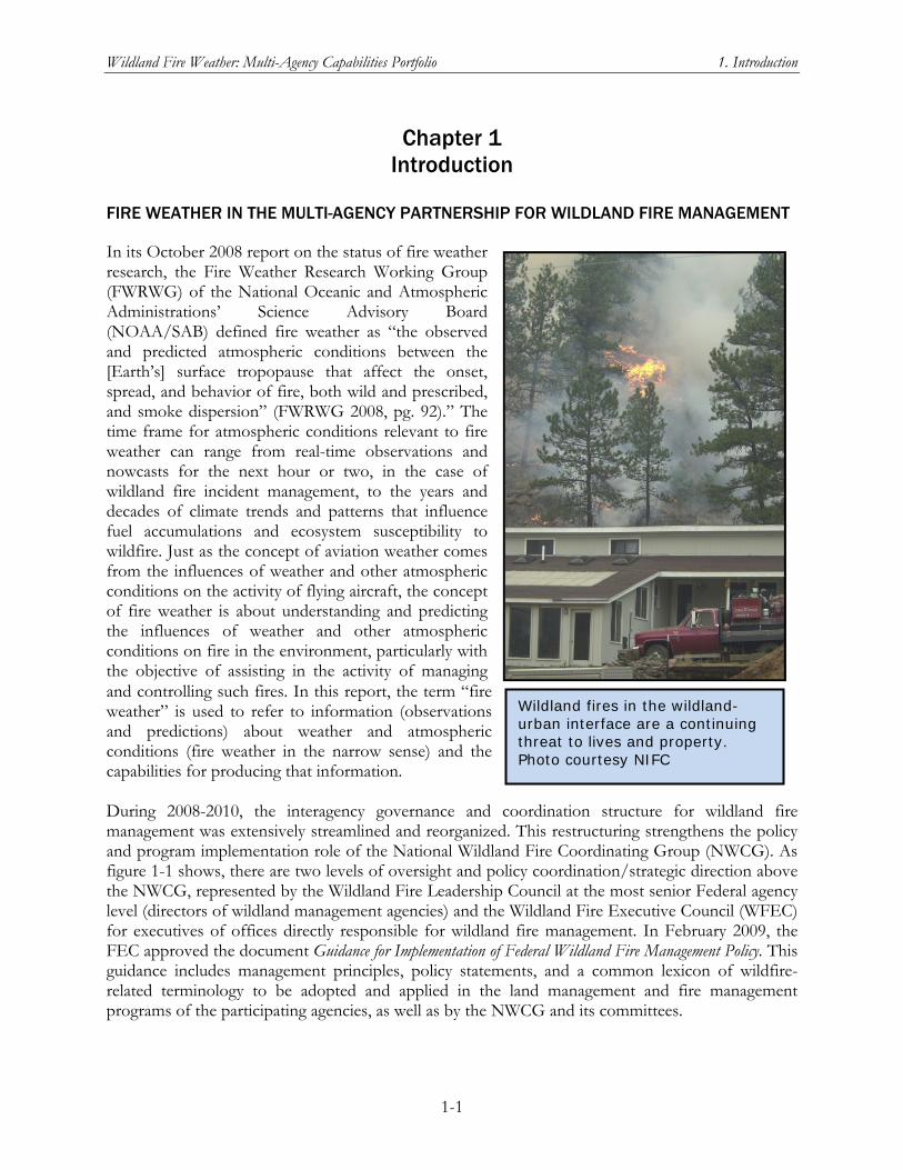
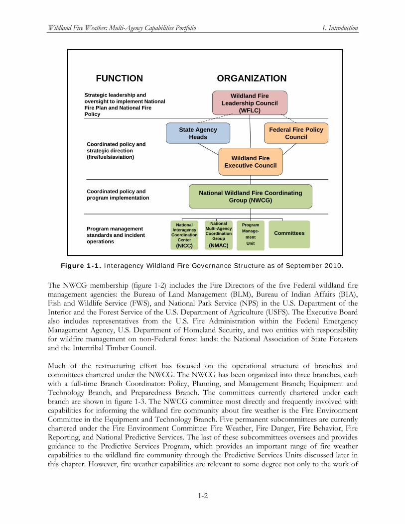
In its October 2008 report on the status of fire weather research, the Fire Weather Research Working Group (FWRWG) of the National Oceanic and Atmospheric Administrations’ Science Advisory Board (NOAA/SAB) defined fire weather as “the observed and predicted atmospheric conditions between the [Earth’s] surface tropopause that affect the onset, spread, and behavior of fire, both wild and prescribed, and smoke dispersion” (FWRWG 2008, pg. 92).” The time frame for atmospheric conditions relevant to fire weather can range from real-time observations and nowcasts for the next hour or two, in the case of wildland fire incident management, to the years and decades of climate trends and patterns that influence fuel accumulations and ecosystem susceptibility to wildfire. Just as the concept of aviation weather comes from the influences of weather and other atmospheric conditions on the activity of flying aircraft, the concept of fire weather is about understanding and predicting the influences of weather and other atmospheric conditions on fire in the environment, particularly with the objective of assisting in the activity of managing and controlling such fires. In this report, the term “fire weather” is used to refer to information (observations and predictions) about weather and atmospheric conditions (fire weather in the narrow sense) and the capabilities for producing that information. During 2008-2010, the interagency governance and coordination structure for wildland fire management was extensively streamlined and reorganized. This restructuring strengthens the policy and program implementation role of the National Wildland Fire Coordinating Group (NWCG). As figure 1-1 shows, there are two levels of oversight and policy coordination/strategic direction above the NWCG, represented by the Wildland Fire Leadership Council at the most senior Federal agency level (directors of wildland management agencies) and the Wildland Fire Executive Council (WFEC) for executives of offices directly responsible for wildland fire management. In February 2009, the FEC approved the document Guidance for Implementation of Federal Wildland Fire Management Policy. This guidance includes management principles, policy statements, and a common lexicon of wildfire-related terminology to be adopted and applied in the land management and fire management programs of the participating agencies, as well as by the NWCG and its committees.
Wildland fires in the wildland-urban interface are a continuing threat to lives and property. Photo courtesy NIFC
Wildland Fire Weather: Multi-Agency Capabilities Portfolio 1. Introduction
1-2
National Multi-Agency Coordination
Group
(NMAC)
National Interagency
Coordination Center
(NICC)
Program
Manage-
ment
Unit
State Agency Heads
Wildland Fire Leadership Council
(WFLC)
National Wildland Fire Coordinating Group (NWCG)
FUNCTION ORGANIZATION
Strategic leadership and oversight to implement National Fire Plan and National Fire Policy
Federal Fire Policy Council
Wildland Fire Executive Council
Committees
Coordinated policy and strategic direction (fire/fuels/aviation)
Coordinated policy and program implementation
Program management standards and incident operations
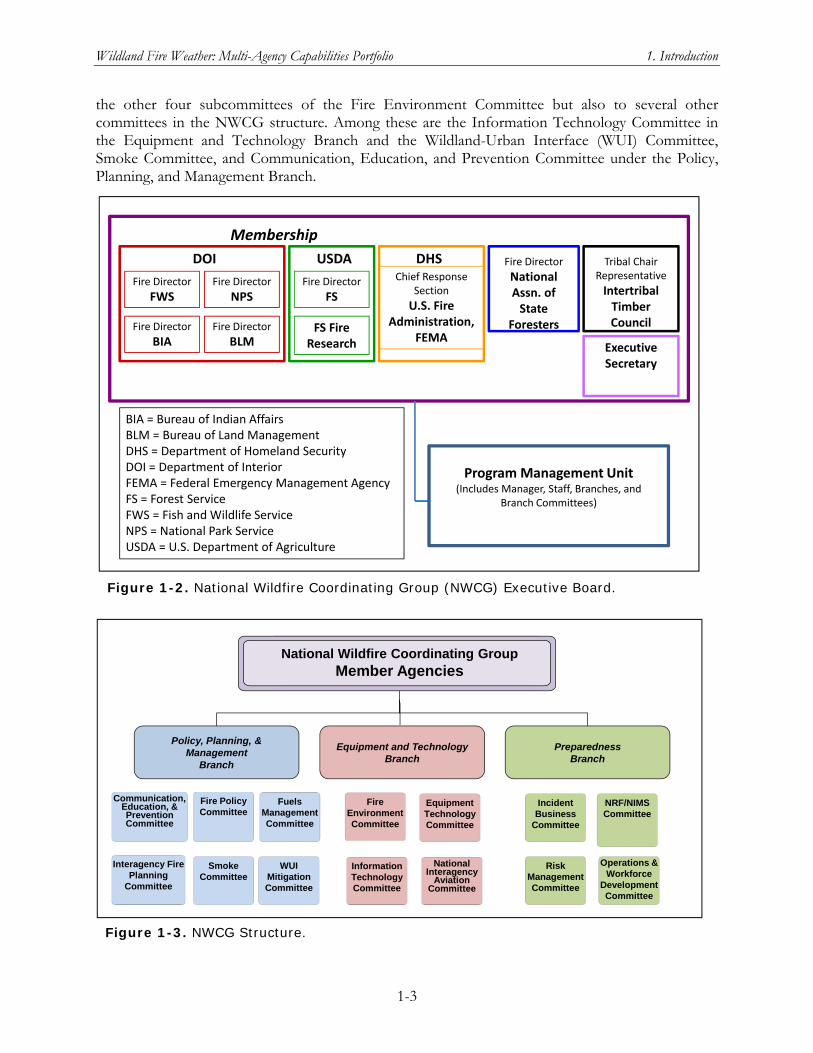
The NWCG membership (figure 1-2) includes the Fire Directors of the five Federal wildland fire management agencies: the Bureau of Land Management (BLM), Bureau of Indian Affairs (BIA), Fish and Wildlife Service (FWS), and National Park Service (NPS) in the U.S. Department of the Interior and the Forest Service of the U.S. Department of Agriculture (USFS). The Executive Board also includes representatives from the U.S. Fire Administration within the Federal Emergency Management Agency, U.S. Department of Homeland Security, and two entities with responsibility for wildfire management on non-Federal forest lands: the National Association of State Foresters and the Intertribal Timber Council. Much of the restructuring effort has focused on the operational structure of branches and committees chartered under the NWCG. The NWCG has been organized into three branches, each with a full-time Branch Coordinator: Policy, Planning, and Management Branch; Equipment and Technology Branch, and Preparedness Branch. The committees currently chartered under each branch are shown in figure 1-3. The NWCG committee most directly and frequently involved with capabilities for informing the wildland fire community about fire weather is the Fire Environment Committee in the Equipment and Technology Branch. Five permanent subcommittees are currently chartered under the Fire Environment Committee: Fire Weather, Fire Danger, Fire Behavior, Fire Reporting, and National Predictive Services. The last of these subcommittees oversees and provides guidance to the Predictive Services Program, which provides an important range of fire weather capabilities to the wildland fire community through the Predictive Services Units discussed later in this chapter. However, fire weather capabilities are relevant to some degree not only to the work of
Figure 1-1. Interagency Wildland Fire Governance Structure as of September 2010.
Wildland Fire Weather: Multi-Agency Capabilities Portfolio 1. Introduction
1-3
the other four subcommittees of the Fire Environment Committee but also to several other committees in the NWCG structure. Among these are the Information Technology Committee in the Equipment and Technology Branch and the Wildland-Urban Interface (WUI) Committee, Smoke Committee, and Communication, Education, and Prevention Committee under the Policy, Planning, and Management Branch.
Fuels Management Committee
Fire Policy Committee
Smoke Committee
Communication, Education, & PreventionCommittee
Information Technology Committee
Equipment Technology Committee
Fire Environment Committee
National Interagency
Aviation Committee
Incident Business
Committee
Operations & Workforce
Development Committee
Risk Management Committee
NRF/NIMS Committee
WUI Mitigation Committee
National Wildfire Coordinating GroupMember Agencies
Policy, Planning, & Management
Branch
Equipment and TechnologyBranch
PreparednessBranch
Interagency Fire Planning
Committee
Figure 1-3. NWCG Structure.
BIA = Bureau of Indian AffairsBLM = Bureau of Land ManagementDHS = Department of Homeland SecurityDOI = Department of InteriorFEMA = Federal Emergency Management AgencyFS = Forest ServiceFWS = Fish and Wildlife ServiceNPS = National Park ServiceUSDA = U.S. Department of Agriculture
DOI USDA DHS
Fire Director
FWS
Fire Director
BIA
Fire Director
NPS
Fire Director
BLM
Fire Director
FS
FS Fire Research
Chief Response Section
U.S. Fire Administration,
FEMA
Fire Director
National Assn. of State
Foresters
Tribal Chair Representative
Intertribal Timber Council
Executive Secretary
Membership
Program Management Unit(Includes Manager, Staff, Branches, and
Branch Committees)
Figure 1-2. National Wildfire Coordinating Group (NWCG) Executive Board.
Wildland Fire Weather: Multi-Agency Capabilities Portfolio 1. Introduction
1-4
NOAA’s National Weather Service (NWS) does not participate as a member of the NWCG, nor is it represented on the oversight and coordinated policy councils above the NWCG level. Senior managers of the NWS Fire Weather Program do participate in NWCG committees and subcommittees, as discussed in the section on NWS roles and capabilities below. The NWS role in supporting the wildland fire community with weather services and products has for many years been specified through a formal Interagency Agreement with the five Federal wildland fire management agencies. The most recent of these agreements was signed in summer 2008 and has an effective period from October 1, 2007, to September 30, 2012 (Interagency Agreement, 2008). Several sections of the agreement are worth quoting in full, as they establish the functional framework for coordination and collaboration between NOAA/NWS, as the Nation’s issuer of forecasts and warnings for protection of life and property, and the Federal agencies with mandates to manage wildland fire.
III. PURPOSE. The purpose of this Interagency Agreement is to identify products and services that are exchanged between the NWS and Wildland Fire Agencies. These products and services are designed to meet the needs of the public and all agencies for the protection of life, cost containment and efficiency to enhance ecosystem health. It is also the purpose of this Agreement to set forth the terms and conditions under which services are requested by the Wildland Fire Agencies. Accurate and timely meteorological and fire danger information is required to manage resources effectively and efficiently. IV. OBJECTIVES. The objectives of this Agreement are: A. Identify those products and services to be exchanged between the NWS and Wildland
Fire Agencies; B. Continue and maintain interagency relationships; and C. Define roles and responsibilities of the NWS and Wildland Fire Agencies.
Section V of the agreement lists responsibilities of the NWS and references the NOAA/NWS Annual Operating Plan for fire weather services as further defining what NWS agrees to provide. The same section lists what the Wildland Fire Agencies agree to provide—including reimbursement to the NWS for onsite meteorological activities in support of incident teams. This onsite support of an incident team is provided by NWS Incident Meteorologists. Section VI specifies a long list of joint responsibilities; it is a blueprint for coordination and collaboration on a wide range of fire weather–relevant procedures, products, and services. As part of the implementation of this formal Interagency Agreement, senior NOAA/NWS managers and technical experts in fire weather at the national and regional levels serve as liaisons to various elements of the formal NWCG structure described above. At the working level, where products and services get delivered to the wildland fire community—including incident teams as they fight wildfires–there are extremely important, if less formal, working relationships between the meteorologists at NWS Weather Forecast Offices (WFOs) who provide fire weather services and products and the broad wildland fire community at all governmental levels from the Federal agencies down to local fire departments.
Wildland Fire Weather: Multi-Agency Capabilities Portfolio 1. Introduction
1-5
One theme of this report is that the robustness and effectiveness of these collaborations, from the topmost National level down to the WFO meteorologist working with local firefighters, is critical to improving fire weather support to the community and ensuring that new research and newly developed know-how add to that support. Improving the contribution of fire weather information to the overall goal of managing wildland fire
risks requires working within the current multi-agency structure represented by the streamlined NWCG. As detailed in chapters 2 through 10 of this report, the vast
majority of both existing capabilities and capabilities in development link into this structure in one way or another. One implication of this point of view is that the emphasis for fire weather R&D coordination should be on supporting and improving information exchange and coordination/collaboration among the existing coordination committees of the NWCG structure, while seeking to reduce redundant efforts and close capability gaps in the broad range of R&D activities conducted or funded by the participating agencies.
THE R&D COMMUNITY FOR IMPROVING FIRE WEATHER PRODUCTS AND SERVICES
Another major reason for emphasizing coordination/collaboration in improving fire weather capabilities nationwide is that a broad and diverse R&D community is already involved in improving existing capabilities and developing, testing, and disseminating new capabilities. It is useful to think of this “fire weather” community as the intersection of two larger R&D communities: an R&D community with a principal focus on supporting wildland fire management and a second community with broad R&D capabilities in atmospheric and Earth sciences, particularly in development of meteorological and climate-related products and services. Just as fire weather products and services serve larger wildland fire management goals and operations, much fire weather R&D is embedded within programs and funding streams that support capability improvement for wildland fire management in general. A good example is the Joint Fire Science Program (JFSP), created by Congress in 1998 as an interagency research, development, and applications partnership of the five wildland fire management agencies in the U.S. Departments of Agriculture and the Interior, plus the U.S. Geological Survey in the Department of the Interior. Through an annual cycle of proposal solicitation, review, and funding of projects selected by a rigorous peer review process, the JFSP pursues its mission of providing credible research directed to the needs of fire and fuel managers. It engages and listens to clients in the land management and
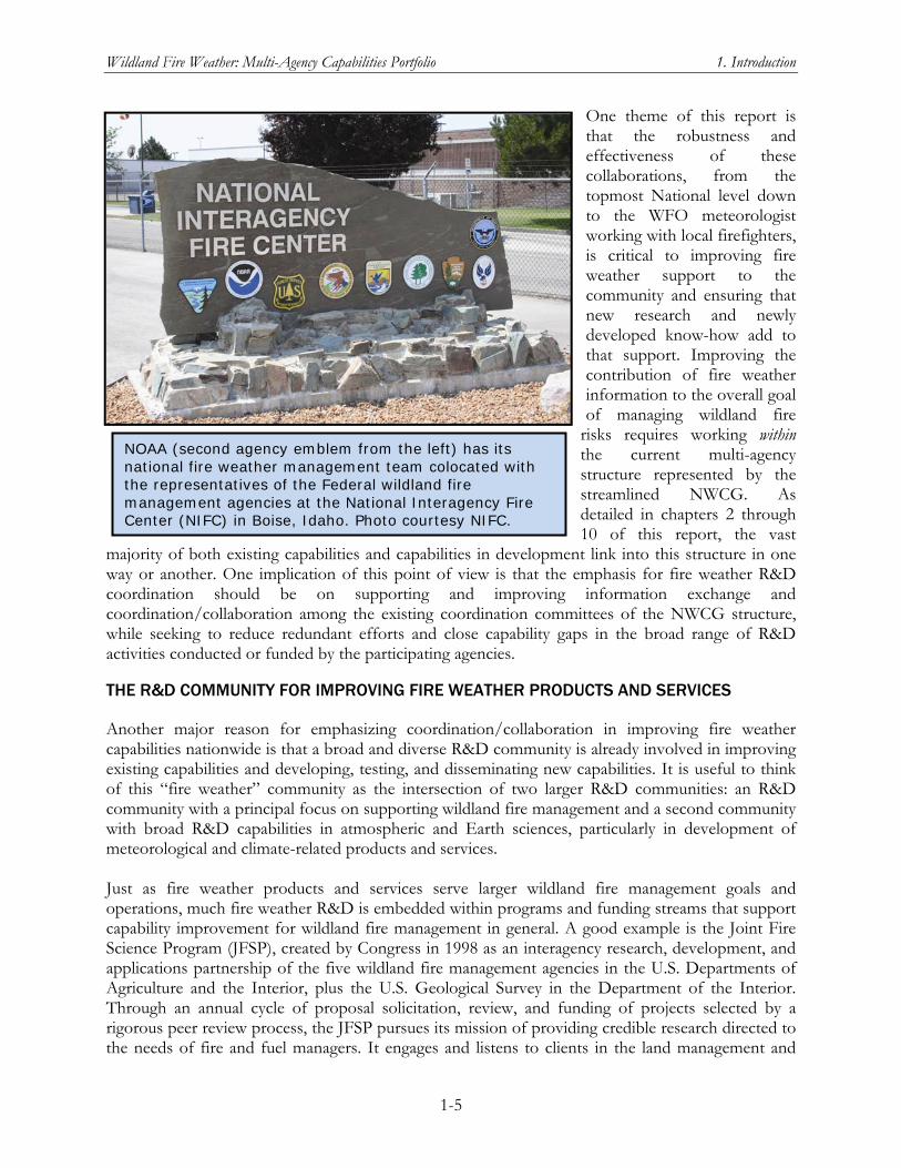
NOAA (second agency emblem from the left) has its national fire weather management team colocated with the representatives of the Federal wildland fire management agencies at the National Interagency Fire Center (NIFC) in Boise, Idaho. Photo courtesy NIFC.
Wildland Fire Weather: Multi-Agency Capabilities Portfolio 1. Introduction
1-6
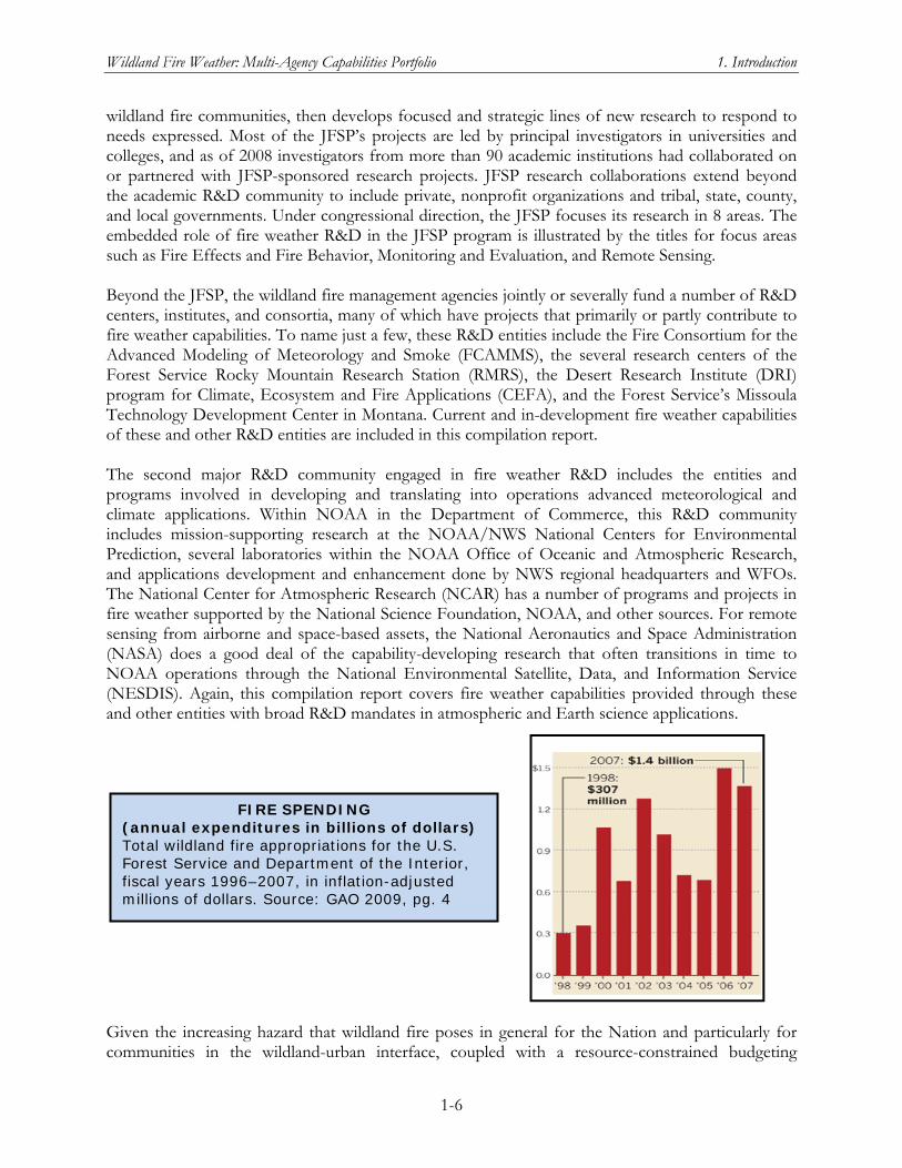
FIRE SPENDING (annual expenditures in billions of dollars) Total wildland fire appropriations for the U.S. Forest Service and Department of the Interior, fiscal years 1996–2007, in inflation-adjusted millions of dollars. Source: GAO 2009, pg. 4
wildland fire communities, then develops focused and strategic lines of new research to respond to needs expressed. Most of the JFSP’s projects are led by principal investigators in universities and colleges, and as of 2008 investigators from more than 90 academic institutions had collaborated on or partnered with JFSP-sponsored research projects. JFSP research collaborations extend beyond the academic R&D community to include private, nonprofit organizations and tribal, state, county, and local governments. Under congressional direction, the JFSP focuses its research in 8 areas. The embedded role of fire weather R&D in the JFSP program is illustrated by the titles for focus areas such as Fire Effects and Fire Behavior, Monitoring and Evaluation, and Remote Sensing. Beyond the JFSP, the wildland fire management agencies jointly or severally fund a number of R&D centers, institutes, and consortia, many of which have projects that primarily or partly contribute to fire weather capabilities. To name just a few, these R&D entities include the Fire Consortium for the Advanced Modeling of Meteorology and Smoke (FCAMMS), the several research centers of the Forest Service Rocky Mountain Research Station (RMRS), the Desert Research Institute (DRI) program for Climate, Ecosystem and Fire Applications (CEFA), and the Forest Service’s Missoula Technology Development Center in Montana. Current and in-development fire weather capabilities of these and other R&D entities are included in this compilation report. The second major R&D community engaged in fire weather R&D includes the entities and programs involved in developing and translating into operations advanced meteorological and climate applications. Within NOAA in the Department of Commerce, this R&D community includes mission-supporting research at the NOAA/NWS National Centers for Environmental Prediction, several laboratories within the NOAA Office of Oceanic and Atmospheric Research, and applications development and enhancement done by NWS regional headquarters and WFOs. The National Center for Atmospheric Research (NCAR) has a number of programs and projects in fire weather supported by the National Science Foundation, NOAA, and other sources. For remote sensing from airborne and space-based assets, the National Aeronautics and Space Administration (NASA) does a good deal of the capability-developing research that often transitions in time to NOAA operations through the National Environmental Satellite, Data, and Information Service (NESDIS). Again, this compilation report covers fire weather capabilities provided through these and other entities with broad R&D mandates in atmospheric and Earth science applications.
Given the increasing hazard that wildland fire poses in general for the Nation and particularly for communities in the wildland-urban interface, coupled with a resource-constrained budgeting
Wildland Fire Weather: Multi-Agency Capabilities Portfolio 1. Introduction
1-7
environment, coordination and collaboration across this diverse and dispersed fire weather R&D community is essential. Without sacrificing innovation and opportunities for discovery and new ways of thinking about complex problems, the Nation needs to optimize the return on its R&D investments in fire weather science and technology. The OFCM approach to this challenge has been to assess the fire weather needs of the wildland fire community, based on input from that community, then determine where there are gaps in meeting those needs and how best to fill them, using the proficiencies and resources of the R&D community. These resources include the immense underlying infrastructure of supporting agencies such as computers; interdisciplinary expertise; vast arrays of instruments and sensors; data handling, processing, and assimilation; and applications of extensive communication technologies and activities.
THE NATIONAL WILDLAND FIRE NEEDS ASSESSMENT
On June 14, 2005, the Western Governors’ Association (WGA) approved Policy Resolution 05-04: National Wildland Fire Weather Program. This resolution called for better coordination of existing research programs in fire weather, as well as additional research, to improve decisions support for those charged with protecting the public and the nation’s natural resources from wildland fire threats. It noted the lack of integration of observing stations such as Remote Automated Weather Stations (RAWS) into a comprehensive observing strategy and called for a strengthened joint interagency effort, encompassing all Federal and non-Federal stakeholders, to transfer new digital weather information and technology into operational fire management decision-making and planning. The full text of this seminal resolution is reproduced as appendix A to this report. Paragraph B.4 of Policy Resolution 05-04 made the following request of NOAA:
The Western Governors urge NOAA to: …
Complete a National Needs Assessment Report, by NOAA’s Office of the Federal Coordinator for Meteorology, of federal, state and local fire managers needs for weather information in their wildfire and prescribed fire decision making processes and a framework to meet those needs by the NWS and Predictive Services.
This request from the Western Governors led directly to the National Wildland Fire Weather Needs Assessment. Shortly after the WGA’s meeting, the NOAA Assistant Administrator for Weather Services contacted the Federal Coordinator and solicited help in conducting a National Needs Assessment. The OFCM operates with policy guidance from the Federal Committee for Meteorological Services and Supporting Research (FCMSSR). FCMSSR is chaired by the Under Secretary of Commerce for Oceans and Atmosphere/NOAA Administrator. The members of the FCMSSR are senior policy executives from the Federal agencies with meteorological programs. The Interdepartmental Committee for Meteorological Services and Supporting Research (ICMSSR), which is chaired by the Federal Coordinator, is the primary program management body of the Federal coordinating structure. ICMSSR provides advice to OFCM, implements policies set by the FCMSSR, and oversees the committees and working groups established for specific areas and projects within the Federal coordinating structure. On November 18, 2005, a meeting of the ICMSSR addressed the request from WGA and approved the following action item:
ACTION ITEM 2005-1.1: National Wildland Fire Needs Assessment. ICMSSR
concurred that OFCM should move forward to form a Joint Action Group (JAG) under the Committee for Environmental Services, Operations, and Research Needs
Wildland Fire Weather: Multi-Agency Capabilities Portfolio 1. Introduction
1-8
(CESORN), to review the needs and requirements for wildland fire weather information, to include identifying organizational responsibilities and addressing the following issues: data collection, fire weather research, weather forecast services, data assimilation, air quality, information dissemination, education and outreach, and user response.
In response to this action item, the Federal Coordinator established the Joint Action Group for National Wildland Fire Weather Needs Assessment (JAG/NWFWNA) to undertake a needs assessment, covering the range of stakeholders in the national wildland fire weather community, for weather and climate information in wildland fire decisionmaking. The JAG/NWFWNA was assigned two primary goals:
1. Conduct a comprehensive review and assessment of weather and climate needs of providers and users in their wildland fire and fuels management activities.
2. Assess the capabilities of the provider and research agencies to ensure that needed weather and climate information is available to fire and air quality managers and other users.
Data collection for the assessment began in the fall of 2006 and was completed in February 2007, after which the JAG/NWFWNA began analyzing the responses received. In addition to federal stakeholder agencies (table 1), which includes both users (e.g., the Wildland Fire Agencies) and providers (NWS and the Predictive Services Units) of wildland fire weather information, many nonfederal stakeholders were included in the needs assessment, such as the following representative but not exhaustive list:
International Association of Fire Chiefs
Intertribal Timber Council
National Association of Counties
National Association of State Foresters
National Fire Protection Association
Nongovernmental organizations (e.g., The Nature Conservancy)
The State and Territorial Air Pollution Program Administrators and the Association of Local Air Pollution Control Officials
Western Governors’ Association
Western States Air Resources Council The JAG/NWFWNA was charged with addressing nine functional areas of wildland fire weather:
Data collection, integrity, processing and archival
Fire weather research and development
Forecast Products and Services
Modeling, prediction, and data assimilation
Information dissemination and technologies

Wildland Fire Weather: Multi-Agency Capabilities Portfolio 1. Introduction
1-9
Education, training, outreach, partnering, and collaboration
User response, decision support, and resulting user impacts
Funding and human resources (crosscutting)
Socioeconomic impacts Table 1. Federal Agency Stakeholders in the Wildland Fire Weather Community
Department of Commerce National Institute of Standards and Technology National Oceanic and Atmospheric Administration
Department of Defense All service components National Guard/Reserve U.S. Army Corps of Engineers
Department of Energy Department of Homeland Security
Federal Emergency Management Agency U.S. Fire Administration
Department of the Interior Bureau of Indian Affairs Bureau of Land Management Bureau of Reclamation National Park Service U.S. Fish and Wildlife Service U.S. Geological Survey
Department of Transportation Federal Aviation Administration Federal Highway Administration Federal Railroad Administration Federal Transit Administration
Environmental Protection Agency Health and Human Services
Centers for Disease Control and Prevention National Aeronautics and Space Administration National Science Foundation U.S. Department of Agriculture
Forest Service Natural Resource Conservation Service
The needs assessment questionnaire asked those who provided input to consider and comment on their needs in each of these functional areas. Each functional area defines requirements and standards for the functions within that area’s scope that are necessary to support sound fire management decisions for planning, preparedness, and incidents; and prescribed fire management during wildland fires. Sound fire management decisions can be either tactical or strategic in scope. More specifically, they can include any of the following considerations:
1. Proactive resource allocations
2. Adjusting daily-to-seasonal staffing and preparedness levels
3. Managing smoke, its impact on air quality, and its effect on public health and safety
4. Assuring the protection of the lives of firefighters and the public
5. Increasing public awareness In its summary report on the needs assessment, the JAG/NWFWNA organized the results into a set of needs statements (OFCM 2007). Each need statement was assigned to the functional area of primary importance to that need, although many of the needs were relevant to several functional areas. Table 2, which is the summary of needs statements from that report, shows the needs statements organized by functional area and with the hierarchical structuring of the needs statements developed by the JAG/NWFWNA. Table 2 is below; further discussion and details regarding the table continue on page 1-16.
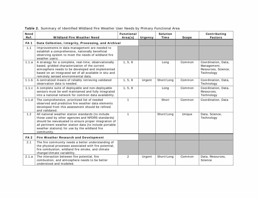
Table 2. Summary of Identified Wildland Fire Weather User Needs by Primary Functional Area
Need Ref. Wildland Fire Weather Need
Functional Area(s) Urgency
Solution Time Scope
Contributing Factors
FA 1 Data Collection, Integrity, Processing, and Archival 1.1 Improvements in data management are needed to
establish a comprehensive, nationally beneficial observing system to meet the needs of wildland fire weather users.
1.1.a A strategy for a complete, real-time, observationally based, gridded characterization of the current atmosphere needs to be developed and implemented based on an integrated set of all available in situ and remotely sensed environmental data.
1, 5, 8 Long Common Coordination, Data, Management, Resources, Science, Technology
1.1.b A centralized means of reliably retrieving validated observation data is needed.
1, 5, 8 Urgent Short/Long Common Coordination, Data, Technology
1.1.c A complete suite of deployable and non-deployable sensors must be well maintained and fully integrated into a national network for common data availability.
1, 5, 8 Long Common Coordination, Data, Resources, Technology
1.1.d The comprehensive, prioritized list of needed observed and predictive fire weather data elements developed from this assessment should be refined and validated.
1 Short Common Coordination, Data
1.2 All national weather station standards (to include those used by other agencies and NFDRS standards) should be reevaluated to ensure proper integration of all pertinent weather station data (to include portable weather stations) for use by the wildland fire community.
1 Short/Long Unique Data, Science, Technology
FA 2 Fire Weather Research and Development 2.1 The fire community needs a better understanding of
the physical processes associated with fire potential, fire combustion, wildland fire smoke, and climate change/climate variability.
2.1.a The interaction between fire potential, fire combustion, and atmosphere needs to be better understood and modeled.
2 Urgent Short/Long Common Data, Resources, Science
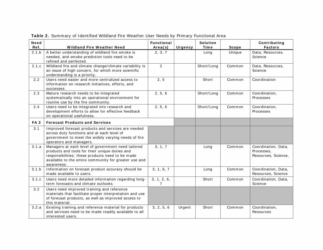
Table 2. Summary of Identified Wildland Fire Weather User Needs by Primary Functional Area
Need Ref. Wildland Fire Weather Need
Functional Area(s) Urgency
Solution Time Scope
Contributing Factors
2.1.b A better understanding of wildland fire smoke is needed, and smoke prediction tools need to be refined and perfected.
2, 3, 7 Long Unique Data, Resources, Science
2.1.c Wildland fire and climate change/climate variability is an issue of high concern, for which more scientific understanding is a priority.
2 Short/Long Common Data, Resources, Science
2.2 Users need easier and more centralized access to information on research initiatives, efforts, and successes.
2, 5 Short Common Coordination
2.3 Mature research needs to be integrated systematically into an operational environment for routine use by the fire community.
2, 5, 6 Short/Long Common Coordination, Processes
2.4 Users need to be integrated into research and development efforts to allow for effective feedback on operational usefulness.
2, 5, 6 Short/Long Common Coordination, Processes
FA 3 Forecast Products and Services 3.1 Improved forecast products and services are needed
across duty functions and at each level of government to meet the widely varying needs of fire operators and managers.
3.1.a Managers at each level of government need tailored products and tools for their unique duties and responsibilities; these products need to be made available to the entire community for greater use and awareness.
3, 1, 7 Long Common Coordination, Data, Processes, Resources, Science,
3.1.b Information on forecast product accuracy should be made available to users.
3, 1, 6, 7 Long Common Coordination, Data, Resources, Science
3.1.c Users need more detailed information regarding long-term forecasts and climate outlooks.
3, 1, 2, 6, 7
Short Common Coordination, Data, Science
3.2 Users need improved training and reference materials that facilitate proper interpretation and use of forecast products, as well as improved access to this material.
3.2.a Existing training and reference material for products and services need to be made readily available to all interested users.
3, 2, 5, 6 Urgent Short Common Coordination, Resources
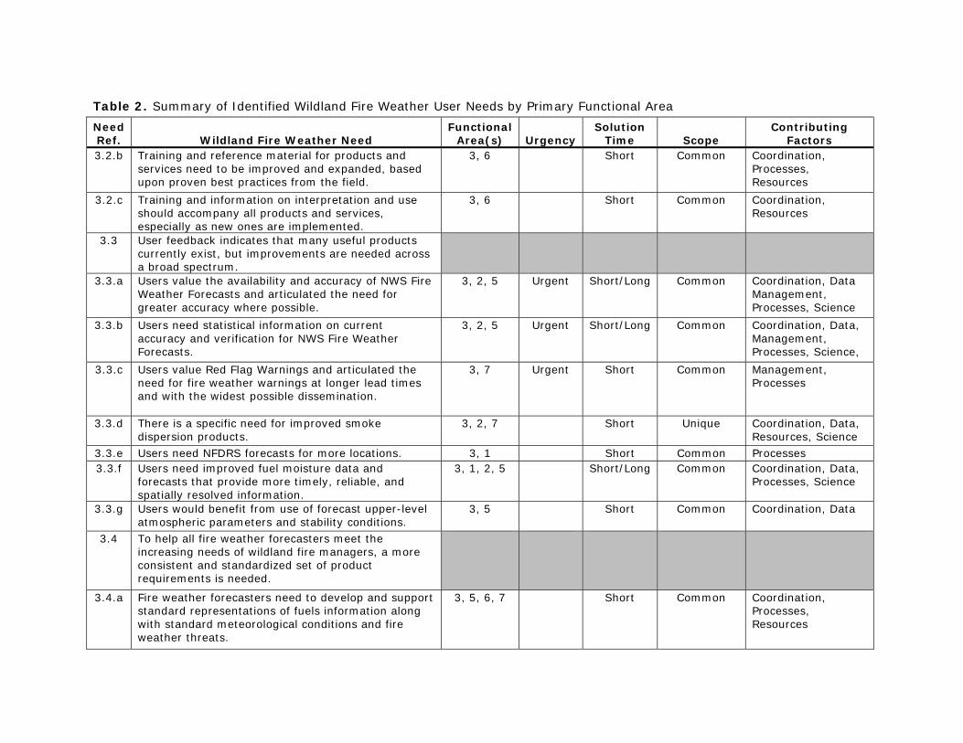
Table 2. Summary of Identified Wildland Fire Weather User Needs by Primary Functional Area
Need Ref. Wildland Fire Weather Need
Functional Area(s) Urgency
Solution Time Scope
Contributing Factors
3.2.b Training and reference material for products and services need to be improved and expanded, based upon proven best practices from the field.
3, 6 Short Common Coordination, Processes, Resources
3.2.c Training and information on interpretation and use should accompany all products and services, especially as new ones are implemented.
3, 6 Short Common Coordination, Resources
3.3 User feedback indicates that many useful products currently exist, but improvements are needed across a broad spectrum.
3.3.a Users value the availability and accuracy of NWS Fire Weather Forecasts and articulated the need for greater accuracy where possible.
3, 2, 5 Urgent Short/Long Common Coordination, Data Management, Processes, Science
3.3.b Users need statistical information on current accuracy and verification for NWS Fire Weather Forecasts.
3, 2, 5 Urgent Short/Long Common Coordination, Data, Management, Processes, Science,
3.3.c Users value Red Flag Warnings and articulated the need for fire weather warnings at longer lead times and with the widest possible dissemination.
3, 7 Urgent Short Common Management, Processes
3.3.d There is a specific need for improved smoke dispersion products.
3, 2, 7 Short Unique Coordination, Data, Resources, Science
3.3.e Users need NFDRS forecasts for more locations. 3, 1 Short Common Processes 3.3.f Users need improved fuel moisture data and
forecasts that provide more timely, reliable, and spatially resolved information.
3, 1, 2, 5 Short/Long Common Coordination, Data, Processes, Science
3.3.g Users would benefit from use of forecast upper-level atmospheric parameters and stability conditions.
3, 5 Short Common Coordination, Data
3.4 To help all fire weather forecasters meet the increasing needs of wildland fire managers, a more consistent and standardized set of product requirements is needed.
3.4.a Fire weather forecasters need to develop and support standard representations of fuels information along with standard meteorological conditions and fire weather threats.
3, 5, 6, 7 Short Common Coordination, Processes, Resources
Table 2. Summary of Identified Wildland Fire Weather User Needs by Primary Functional Area
Need Ref. Wildland Fire Weather Need
Functional Area(s) Urgency
Solution Time Scope
Contributing Factors
3.4.b Fire weather forecasters need clear depictions of critical and standardized threshold/breakpoint conditions on their standard product suite of analyses, forecasts, and decision-support tools.
3, 5, 6, 7 Short/Long
Common Coordination, Processes, Resources
3.4.c The fire community needs to establish accuracy requirements for fire weather products and services to enable the provider community to focus improvement efforts where most beneficial.
3, 2, 5, 6 Short/Long Common Coordination, Processes, Resources
FA 4 Modeling, Prediction, and Data Assimilation 4.1 Fire weather users and the meteorological
community require the rapid transfer of fine-scale modeling, coupled fire-atmosphere modeling, and climate modeling advances into operations; emphasizing capabilities, limitations, and current improvement efforts.
4.1.a Users overwhelmingly need higher resolution meteorological model fields in complex terrain and the tools and input data to understand fire behavior and smoke dispersion.
4, 1, 2, 3, 5, 7
Urgent Long Common Coordination, Data, Processes, Resources, Science
4.1.b Users need model accuracy and confidence information presented to them in an understandable format.
4, 1, 2, 3, 5, 7
Short/Long Common Coordination, Data, Processes, Resources, Science
4.1.c The fire community needs better modeling of fire potential, threat, and impacts associated with climate and climate change.
4, 1, 2, 3, 5, 7
Long Common Coordination, Data, Processes, Resources, Science
4.1.d Model output information needs to be made available in easy-to-use graphics and in high-bandwidth and low-bandwidth formats for use with workstations, PDAs, and text messaging. Products also need to be available in GIS format.
4, 1, 2, 3, 5, 7
Long Common Coordination, Data, Processes, Resources, Science
FA 5 Information Dissemination and Technologies 5.1 A coordinated, “one-stop” fire weather Internet
presence is needed to facilitate fire weather user access to pertinent weather data and products for their region of interest.
5, 1, 2, 3, 4, 6, 7
Urgent Short Common Coordination, Processes, Resources
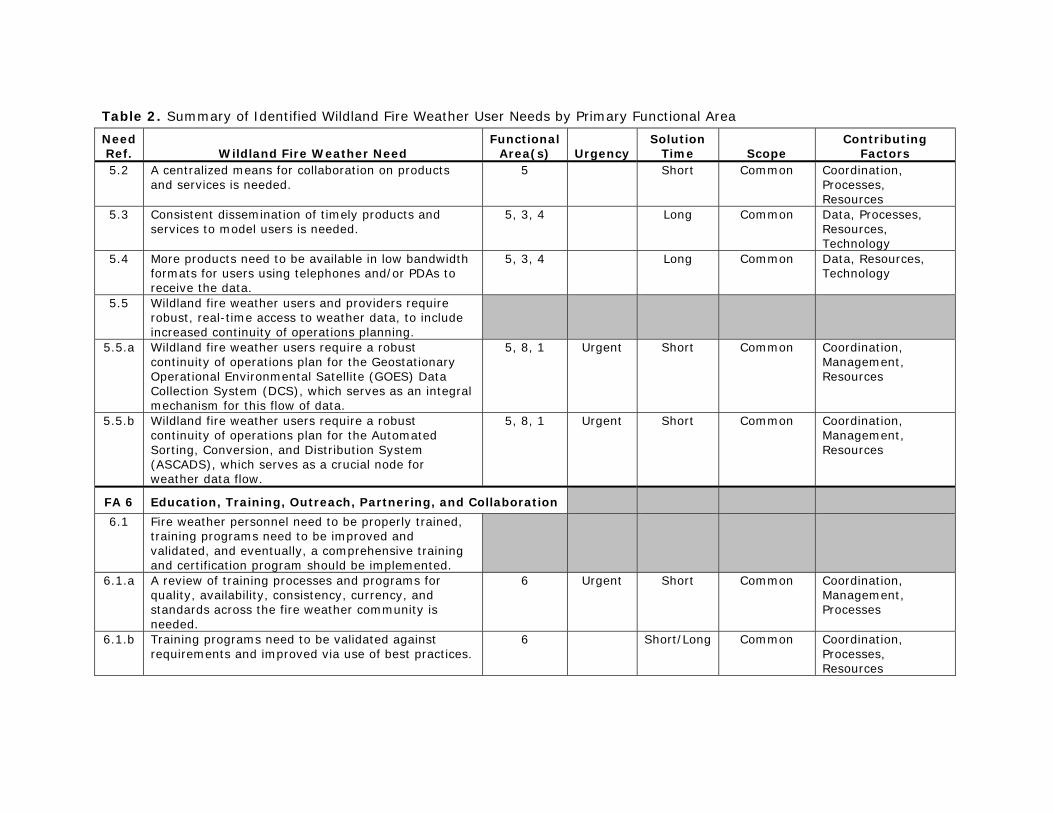
Table 2. Summary of Identified Wildland Fire Weather User Needs by Primary Functional Area
Need Ref. Wildland Fire Weather Need
Functional Area(s) Urgency
Solution Time Scope
Contributing Factors
5.2 A centralized means for collaboration on products and services is needed.
5 Short Common Coordination, Processes, Resources
5.3 Consistent dissemination of timely products and services to model users is needed.
5, 3, 4 Long Common Data, Processes, Resources, Technology
5.4 More products need to be available in low bandwidth formats for users using telephones and/or PDAs to receive the data.
5, 3, 4 Long Common Data, Resources, Technology
5.5 Wildland fire weather users and providers require robust, real-time access to weather data, to include increased continuity of operations planning.
5.5.a Wildland fire weather users require a robust continuity of operations plan for the Geostationary Operational Environmental Satellite (GOES) Data Collection System (DCS), which serves as an integral mechanism for this flow of data.
5, 8, 1 Urgent Short Common Coordination, Management, Resources
5.5.b Wildland fire weather users require a robust continuity of operations plan for the Automated Sorting, Conversion, and Distribution System (ASCADS), which serves as a crucial node for weather data flow.
5, 8, 1 Urgent Short Common Coordination, Management, Resources
FA 6 Education, Training, Outreach, Partnering, and Collaboration 6.1 Fire weather personnel need to be properly trained,
training programs need to be improved and validated, and eventually, a comprehensive training and certification program should be implemented.
6.1.a A review of training processes and programs for quality, availability, consistency, currency, and standards across the fire weather community is needed.
6 Urgent Short Common Coordination, Management, Processes
6.1.b Training programs need to be validated against requirements and improved via use of best practices.
6 Short/Long Common Coordination, Processes, Resources
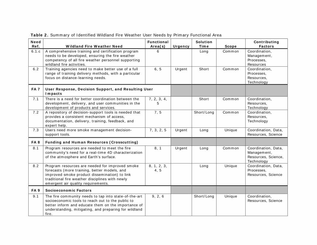
Table 2. Summary of Identified Wildland Fire Weather User Needs by Primary Functional Area
Need Ref. Wildland Fire Weather Need
Functional Area(s) Urgency
Solution Time Scope
Contributing Factors
6.1.c A comprehensive training and certification program needs to be developed, ensuring the fire weather competency of all fire weather personnel supporting wildland fire activities.
6 Long Common Coordination, Management, Processes, Resources
6.2 Training agencies need to make better use of a full range of training delivery methods, with a particular focus on distance-learning needs.
6, 5 Urgent Short Common Coordination, Processes, Resources, Technology
FA 7 User Response, Decision Support, and Resulting User Impacts
7.1 There is a need for better coordination between the development, delivery, and user communities in the development of products and services.
7, 2, 3, 4, 5
Short Common Coordination, Resources, Technology
7.2 A repository of decision-support tools is needed that provides a consistent mechanism of access, documentation, delivery, training, feedback, and expert help.
7, 5 Short/Long Common Coordination, Resources, Technology
7.3 Users need more smoke management decision-support tools.
7, 3, 2, 5 Urgent Long Unique Coordination, Data, Resources, Science
FA 8 Funding and Human Resources (Crosscutting) 8.1 Program resources are needed to meet the fire
community’s need for a real-time 4D characterization of the atmosphere and Earth’s surface.
8, 1 Urgent Long Common Coordination, Data, Management, Resources, Science, Technology
8.2 Program resources are needed for improved smoke forecasts (more training, better models, and improved smoke product dissemination) to link traditional fire weather disciplines with newly emergent air quality requirements.
8, 1, 2, 3, 4, 5
Long Unique Coordination, Data, Processes, Resources, Science
FA 9 Socioeconomic Factors 9.1 The fire community needs to tap into state-of-the-art
socioeconomic tools to reach out to the public to better inform and educate them on the importance of understanding, mitigating, and preparing for wildland fire.
9, 2, 6 Short/Long Unique Coordination, Resources, Science
Wildland Fire Weather: Multi-agency Capabilities Portfolio 1. Introduction
1-16
Each needs statement (second column of table 2) was assigned a reference number (first column). The first segment of this reference number refers to the primary functional area to which that need is essential. Many of the needs are also relevant to other functional areas beyond this primary area, and all the relevant areas are listed in the third column of table 2. The JAG considered with care which of the needs were truly urgent with respect to the imperatives of saving lives and preventing injury, whether to wildland firefighters or members of the public exposed to the various threats posed by wildland fire. Reducing loss of property or other economic losses was also considered, but was not given as much weight as the life and injury criterion. The JAG identified 14 needs as urgent by this stringent test. These urgent needs are noted in column 4 of table 2. Each need is also characterized as to the time frame over which the need can feasibly be met. In the “Solution Time” column of table 2, “short” indicates the need can be met within one to two years, given adequate resources. “Long” indicates that more time will probably be necessary to meet the need fully. For some needs, something of value can be done quickly, even though fully meeting the need is a long-term challenge. Needs in this category are classified as “short/long” in table 2. The “Scope” column in table 2 indicates whether the need applies broadly across the wildland fire community (a “common” need) or is primarily unique to a limited sector of that community. The final column of table 2 lists the hurdles that the JAG considers to be most important to overcome in order to meet a stated need effectively and comprehensively across the national wildland fire community. The following “Contributing Factors” to each need are represented in the table:
Coordination. A major obstacle to meeting the need will be horizontal coordination between agencies/entities at the same level (e.g., two or more Federal entities or entities across the State level), vertical coordination (e.g., Federal, State, and local entities working together), or both horizontal and vertical coordination.
Data. Primarily, this factor represents observing data that are either not collected at sufficient spatial or temporal intervals, not collected routinely (observing systems not in place), or are not available to users within the time constraints of their data-dependent decisions.
Management. Policies and/or management priorities and attitudes need to change in order for the need to be most effectively addressed.
Processes. The way in which things are done now is a substantial part of the problem, and changing the process will be necessary to meet the need. A process constraint combined with coordination or management constraints can often be more difficult to overcome than a pure data or technology constraint.
Resources. Meeting the need will require additional resources of funding (fiscal resources), proficient personnel (human resources), or both. It is often difficult to decide whether a resource constraint is really a management constraint (and vice versa), given that difficult resource allocation decisions must be made in accordance with managerial and institutional priorities.
Wildland Fire Weather: Multi-agency Capabilities Portfolio 1. Introduction
1-17
Science. Either our fundamental understanding is insufficient—and there is a need for basic research—or not enough is known about how to apply fundamental knowledge to solve a particular application problem—which defines an applied research need. At some point, applied research issues become technology issues.
Technology. This term was intended primarily for circumstances where the technological capability generally exists but needs to be adapted or applied to the wildland fire need. If the way to do that adaptation is not yet known, then there probably is also an (applied) science factor as well.
On May 31, 2007, the ICMSSR approved the needs summary report. The Federal Coordinator briefed the Western Governor’s Association on June 11, 2007. At that meeting, the WGA voiced its approval and continued support for this summary needs evaluation and for the overall assessment effort. In 2006–2007, when the JAG/NWFWNA went to the wildland fire management community to identify and validate a set of vital capability shortfalls and opportunities, the capability needs identified through that assessment process existed within the multi-agency structure as it existed at that time. Since then, substantial changes have taken place, in part to address those needs, as well as to address needs assessed through other channels.1 Even so, much remains to be done. In part, this unfinished business reflects limitations in resources of several times: funding constraints, a shortage of knowledgeable practitioners given the ongoing demands of wildland fire management, and in some instances a lack of the fundamental understanding needed to develop the products and services users are requesting. A second factor is that the process of weighing implemented capabilities against users’ needs has been, and should be, an ongoing activity that is never complete and finished. There are likely to be shortfalls even after a need is identified and acknowledged, particularly in the current environment of worsening resource constraints coupled with increasing wildland fire incidence and severity. Although 2 years old, the NWFWNA continues to provide a broad, cross-agency foundation for guiding a coordinated approach to improving the role that fire weather plays in wildland fire management.
NOAA/NWS OPERATIONAL, ADVISORY, AND R&D ROLES
For the purposes of compiling a portfolio of national fire weather capabilities, the many fire weather and related activities of NOAA’s National Weather Service can be roughly grouped under three headings: operational products and services, advisory/coordination roles in the NWCG structure, and R&D aimed at improving and enhancing NWS products and services.
Operational Products and Services
NWS operational products and services originate from the extensive data networks, communications, and computer processing infrastructure that support the basic analysis and
1 The National Predictive Services Group (predecessor to the National Predictive Services Subcommittee) commissioned a user needs assessment that was conducted in roughly the same time frame as the NWFWNA. The NWS routinely surveys its user communities to ascertain how well users’ needs are being met and whether new needs are emerging that are within the NWS mission.
Wildland Fire Weather: Multi-agency Capabilities Portfolio 1. Introduction
1-18
prediction products disseminated to all interested users via the National Digital Forecast Database (NDFD), NWS Family of Services (FOS), NOAA Weather Wire Service (NWWS), NWS Telecommunication Gateway (NWSTG) and NOAAPORT, NOAA Weather Radio, Emergency Manager Weather Information Network (EMWIN), and Internet websites. These routine but essential products complement and build upon the satellite-based observational data provided by NESDIS. While the NWS and NESDIS data sources and data processing and forecasting infrastructure are not specific to fire weather applications, the products and services produced with them are widely used in one form or another not only as inputs to fire weather–specific products and services from the NWS but also by operational units in the wildland fire community as essential input to their own guidance and forecast products and services. The NWS Fire Weather Program encompasses the products and services produced by NWS entities—principally individual WFOs—specifically to support wildland fire management. At a national level, the Fire Weather Program is guided by NWS Policy Directive 10-4, Products and Services to Support Fire and Other Incidents.2 This Policy Directive and its implementing procedural directives (instructions and region-specific supplements) in effect specify how the NWS plans to carry out its responsibilities under the Interagency Agreement with the wildland fire management agencies. Procedures for onsite meteorologist support to wildland fire incident teams—the Incident Meteorologist (IMET) program—are specified in NWS Instruction 10-402, Fire Weather Services On-Site Support). The IMET program is coordinated and implemented nationally by the National Fire Weather Operations Coordinator and the National Fire Weather Program Manager, located at the NIFC in Boise (NWS 2006). Some core grids disseminated via the NDFD grids are produced specifically for fire weather support (NWS, 2009b). The following Fire Weather Program services and products are area- or region-specific and are prepared and delivered at the WFO level (NWS, 2009b). Red Flag Warnings and Fire Weather Watches are issued by WFOs when the combination of dry fuels and weather conditions support an assessment of extreme fire danger and/or fire behavior. In a given area, the criteria for a Red Flag event are coordinated between local WFO personnel and land management users. Furthermore, NWS forecasters are directed to coordinate with local fire and land managers and with the relevant Predictive Services unit prior to issuing a Fire Weather Watch or Red Flag Warning. A Red Flag Warning is issued when local conditions will meet the established criteria for a Red Flag event within 24 hours. A Fire Weather Watch indicates a high potential for the Red Flag criteria to be met. For a dry thunderstorm event, a Fire Weather Watch is issued only for the first 12-hour period. For other conditions, the watch is issued for a period from 12 to 96 hours before the Red Flag conditions are expected to occur. Only the NWS issues Red Flag Warnings.
2 The current version of this policy directive became effective on September 8, 2009. It and the related Service Instructions are available online at http://www.weather.gov/directives/010/010.htm. The previous version of Policy Directive 10-4, dated October 18, 002, was titled “Fire Weather Services.”
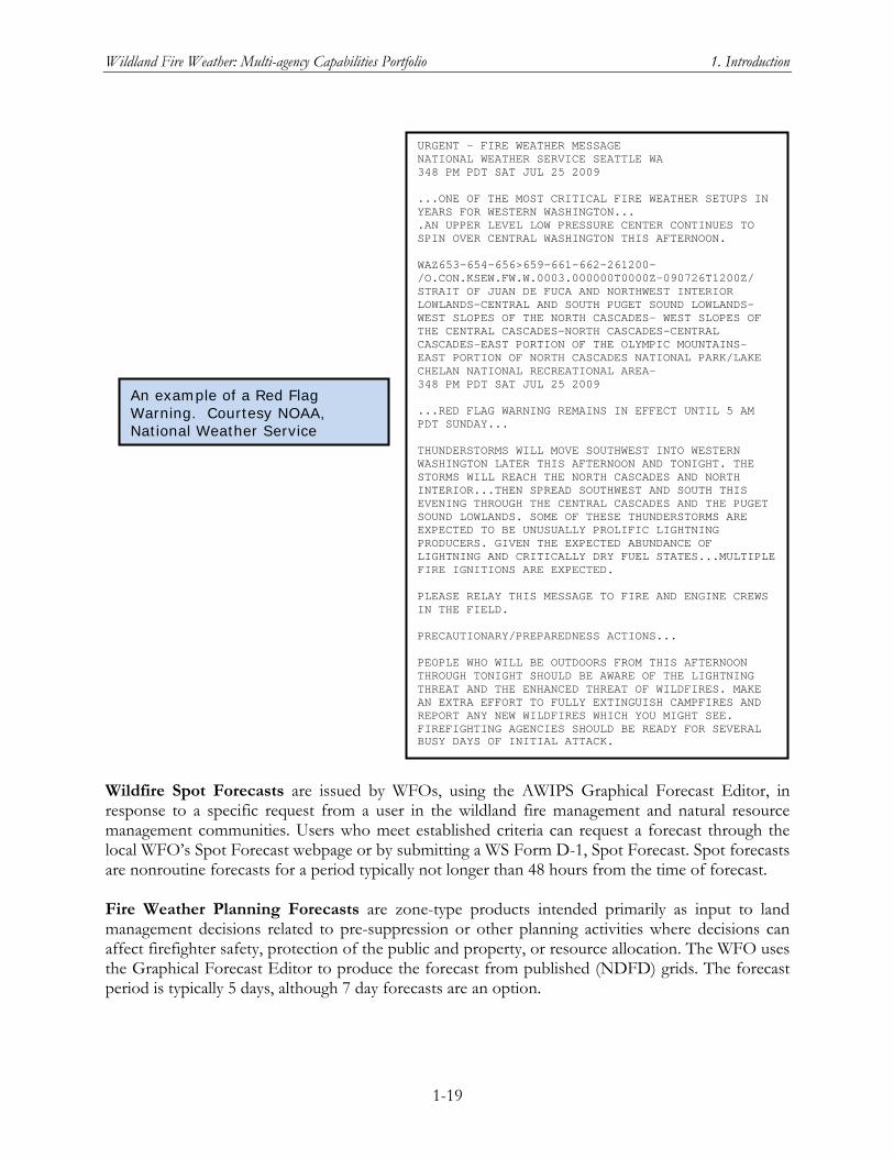
Wildland Fire Weather: Multi-agency Capabilities Portfolio 1. Introduction
1-19
Wildfire Spot Forecasts are issued by WFOs, using the AWIPS Graphical Forecast Editor, in response to a specific request from a user in the wildland fire management and natural resource management communities. Users who meet established criteria can request a forecast through the local WFO’s Spot Forecast webpage or by submitting a WS Form D-1, Spot Forecast. Spot forecasts are nonroutine forecasts for a period typically not longer than 48 hours from the time of forecast. Fire Weather Planning Forecasts are zone-type products intended primarily as input to land management decisions related to pre-suppression or other planning activities where decisions can affect firefighter safety, protection of the public and property, or resource allocation. The WFO uses the Graphical Forecast Editor to produce the forecast from published (NDFD) grids. The forecast period is typically 5 days, although 7 day forecasts are an option.
URGENT - FIRE WEATHER MESSAGE NATIONAL WEATHER SERVICE SEATTLE WA 348 PM PDT SAT JUL 25 2009 ...ONE OF THE MOST CRITICAL FIRE WEATHER SETUPS IN YEARS FOR WESTERN WASHINGTON... .AN UPPER LEVEL LOW PRESSURE CENTER CONTINUES TO SPIN OVER CENTRAL WASHINGTON THIS AFTERNOON. WAZ653-654-656>659-661-662-261200- /O.CON.KSEW.FW.W.0003.000000T0000Z-090726T1200Z/ STRAIT OF JUAN DE FUCA AND NORTHWEST INTERIOR LOWLANDS-CENTRAL AND SOUTH PUGET SOUND LOWLANDS- WEST SLOPES OF THE NORTH CASCADES- WEST SLOPES OF THE CENTRAL CASCADES-NORTH CASCADES-CENTRAL CASCADES-EAST PORTION OF THE OLYMPIC MOUNTAINS- EAST PORTION OF NORTH CASCADES NATIONAL PARK/LAKE CHELAN NATIONAL RECREATIONAL AREA- 348 PM PDT SAT JUL 25 2009 ...RED FLAG WARNING REMAINS IN EFFECT UNTIL 5 AM PDT SUNDAY... THUNDERSTORMS WILL MOVE SOUTHWEST INTO WESTERN WASHINGTON LATER THIS AFTERNOON AND TONIGHT. THE STORMS WILL REACH THE NORTH CASCADES AND NORTH INTERIOR...THEN SPREAD SOUTHWEST AND SOUTH THIS EVENING THROUGH THE CENTRAL CASCADES AND THE PUGET SOUND LOWLANDS. SOME OF THESE THUNDERSTORMS ARE EXPECTED TO BE UNUSUALLY PROLIFIC LIGHTNING PRODUCERS. GIVEN THE EXPECTED ABUNDANCE OF LIGHTNING AND CRITICALLY DRY FUEL STATES...MULTIPLE FIRE IGNITIONS ARE EXPECTED. PLEASE RELAY THIS MESSAGE TO FIRE AND ENGINE CREWS IN THE FIELD. PRECAUTIONARY/PREPAREDNESS ACTIONS... PEOPLE WHO WILL BE OUTDOORS FROM THIS AFTERNOON THROUGH TONIGHT SHOULD BE AWARE OF THE LIGHTNING THREAT AND THE ENHANCED THREAT OF WILDFIRES. MAKE AN EXTRA EFFORT TO FULLY EXTINGUISH CAMPFIRES AND REPORT ANY NEW WILDFIRES WHICH YOU MIGHT SEE. FIREFIGHTING AGENCIES SHOULD BE READY FOR SEVERAL BUSY DAYS OF INITIAL ATTACK.
An example of a Red Flag Warning. Courtesy NOAA, National Weather Service
Wildland Fire Weather: Multi-agency Capabilities Portfolio 1. Introduction
1-20
National Fire Danger Rating System (NFDRS) Forecasts. The NFDRS is a set of computer programs and algorithms that enable land management agencies and NWS WFOs to estimate the fire danger for a specified rating area during the next 24 hours or longer. The NWS role with respect to NFDRS is to forecast the weather inputs to the software used to compute the next day’s fire danger indices. Participating WFOs prepare these weather forecast inputs to the NFDRS runs as a special-format product called the NFDRS Forecast, or FWM. For more on the NFDRS software see the entry for “WFAS and NFDRS” in the Crosscutting Capabilities section of chapter 4. Other forecast products that WFOs may produce include a Land Management Forecast, Smoke Management Forecast, and Rangeland/Grassland Fire Danger Statement. A local WFO will work with local users of these products to develop standards for content, format, frequency, dissemination, etc., of the forecasts. A Fire Weather Annual Operating Plan, which can be established for an individual WFOs or at the state or regional level, specifies how the WFOs operating under that plan will provide the above products and services to the wildland fire community. Every WFO that issues nonroutine fire weather products during its fire weather season also produces an Annual Report summarizing its fire support activities during the past year for its area of responsibility (NWS 2007) The NWS Storm Prediction Center produces national Fire Weather Outlooks for three forecast periods: Day One, Day two, and Day 3–8. These scheduled products (issued daily) combine narrative and graphical description of large-scale meteorological conditions in the contiguous United States that, when combined with the fuel conditions in the forecast period, favor the rapid growth and spread of a wildfire, should a fire ignition occur. The outlooks are intended to provide guidance aid land management agencies in determining large scale areas of fire danger risk and to aid WFO forecasters (NWS 2009b).
NWS Advisory/Coordination Roles
The Chief of the Fire and Public Weather Services Branch of the NWS is a member of the NWCG Fire Environment Committee. The NWS Western Region Meteorologist-in-Charge (MIC) is a member of the National Predictive Services Subcommittee. The NWS National Fire Weather Program Manager and National Fire Weather Operations Coordinator frequently participate in or are members of other FEC subcommittees. As noted above, NWS procedures call for WFO-level Fire Level Program Leaders to coordinate fire weather services and area-specific products with users in their area of responsibility, including the Geographic Area Coordination Centers (GACCs) of the wildland fire management agencies. In the Pacific Northwest, six WFOs (Seattle, Portland, Medford, Spokane, Pendleton, and Boise) have developed a joint Northwest Area Fire Weather Annual Operating Plan in agreement with the Pacific Northwest Wildfire Coordinating Group, which includes State, local government, and Federal land management agencies with responsibilities for protecting life, property, and resources in the Pacific Northwest from wildfire threats. This joint Operating Plan includes sections for roles and responsibilities of the Predictive Services Unit at the Northwest Interagency Coordination Center (the region’s GACC) and for the Fire and Smoke Management Services of the Oregon Department of Forestry’s Salem Center. A more typical pattern is coordination of WFO fire weather services in an Annual Operating Plan at the State level. For other GACCs, there appears to be considerable variation in the frequency and depth of consultation and coordination between the Predictive
Wildland Fire Weather: Multi-agency Capabilities Portfolio 1. Introduction
1-21
Services Unit at the GACC and the WFOs whose areas of responsibility fall within or overlap with the GACC’s geographic region.
NWS R&D in Support of Fire Weather Products and Services
In response to WGA Policy Resolution 05-04, National Wildland Fire Weather Program, which initiated the OFCM effort to conduct a National Wildland Fire Weather Needs Assessment, NOAA in 2006 further requested its Science Advisory Board to establish an ad hoc working group to:
1. ensure NOAA’s fire weather research priorities match those of its land management partners and other interested parties outside the fire community who are increasingly using NOAA’s products and services, and
2. explore opportunities to leverage current NOAA-internal and external collaborative fire weather research efforts to ensure NOAA’s fire weather products and services are implemented in a timely manner.
The report of the Fire Weather Research Working Group, which carried out this task for the SAB, was released in October 2008 with the title Fire Weather Research: A Burning Agenda for NOAA (FWRWG 2008). The FWRWG summarized its results into 19 findings, with from one to five recommendations per finding. Each finding was preceded by a narrative section of observations, which provide the rationale and context for the finding and recommendations. The full text of the recommendations has been reproduced for this report as appendix B. The FWRWG report should be consulted for the insightful observations and arguments it provides in support of the findings, as well as for the actual wording of the 19 findings, which are only summarized here and in appendix B. For this report, fire weather capabilities from across all Federal entities including the NWS, as well as partnering entities in academia and the private sector, have been organized according to the NWFWNA needs to which they are relevant. For a report on the multiagency portfolio of capabilities, this organization is more appropriate than attempting to organize all current and in-development capabilities under the finding/recommendation structure of the FWRWG report, which per its charge focused nearly exclusively on NOAA/NWS capabilities and research needed to improve them. Nonetheless, correlating the findings and recommendations of the FWRWG with the NWFWNA user needs is a crucial and useful step toward coordinating multiagency fire weather R&D in order to meet the needs of the wildland fire community. The matrix in appendix C provides a detailed correlation between all 46 SAB recommendations (the rows of the matrix) and the NWFWNA user needs to which each recommendation is relevant (columns of the matrix). The FWRWG identified 11 of its 46 recommendations as being of higher priority as NOAA considers next steps in advancing its fire weather products and services (FWRWG 2008, pg. 5). In table 3, these high priority recommendations are listed with the NWFWNA user needs to which they are relevant. The full matrix in appendix C shows that each of the NWFWNA user needs has at least one FWRWG recommendation relevant to it, and each FWRWG recommendation addresses at least one relevant user need.
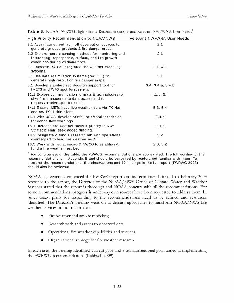
Wildland Fire Weather: Multi-agency Capabilities Portfolio 1. Introduction
1-22
Table 3. NOAA FWRWG High Priority Recommendations and Relevant NWFWNA User Needsa
High Priority Recommendation to NOAA/NWS Relevant NWFWNA User Needs
2.1 Assimilate output from all observation sources to generate gridded products & fire danger maps.
2.1
2.2 Explore remote sensing methods for monitoring and forecasting tropospheric, surface, and fire growth conditions during wildland fires.
2.1
3.1 Increase R&D of integrated fire weather modeling systems.
2.1, 4.1
5.1 Use data assimilation systems (rec. 2.1) to generate high resolution fire danger maps.
3.1
8.1 Develop standardized decision support tool for IMETS and WFO spot forecasters.
3.4, 3.4.a, 3.4.b
12.1 Explore communication formats & technologies to give fire managers site data access and to request/receive spot forecasts.
4.1.d, 5.4
14.1 Ensure IMETs have live weather data via FX-Net and AWIPS II thin client.
5.3, 5.4
15.1 With USGS, develop rainfall rate/total thresholds for debris flow warnings.
3.4.b
18.1 Increase fire weather focus & priority in NWS Strategic Plan; seek added funding.
1.1.c
18.2 Designate & fund a research lab with operational counterpart to lead fire weather R&D.
5.2
18.3 Work with Fed agencies & NWCG to establish & fund a fire weather test bed
2.3, 5.2
a For conciseness of the table, the FWRWG recommendations are abbreviated. The full wording of the recommendations is in Appendix B and should be consulted by readers not familiar with them. To interpret the recommendations, the observations and 19 findings in the full report (FWRWG 2008) should also be reviewed. NOAA has generally embraced the FWRWG report and its recommendations. In a February 2009 response to the report, the Director of the NOAA/NWS Office of Climate, Water and Weather Services stated that the report is thorough and NOAA concurs with all the recommendations. For some recommendations, progress is underway or resources have been requested to address them. In other cases, plans for responding to the recommendations need to be refined and resources identified. The Director’s briefing went on to discuss approaches to transform NOAA/NWS fire weather services in four major areas:
Fire weather and smoke modeling
Research with and access to observed data
Operational fire weather capabilities and services
Organizational strategy for fire weather research In each area, the briefing identified current gaps and a transformational goal, aimed at implementing the FWRWG recommendations (Caldwell 2009).
Wildland Fire Weather: Multi-agency Capabilities Portfolio 1. Introduction
1-23
ROLE OF PREDICTIVE SERVICES UNITS IN MULTI-AGENCY WILDLAND FIRE MANAGEMENT
In the 2000 fire season, more fires than had occurred in any of the previous 50 years caused unprecedented damage. That season, 122,827 fires burned 8,422,237 acres and nearly 900 homes and other structures were destroyed. President Clinton requested that the Secretaries of Agriculture and the Interior prepare what became the National Fire Plan, to respond to severe wildland fires, reduce the impact of wildfires on rural communities, and ensure sufficient firefighting capacity. The Plan called for actions that Federal agencies, in cooperation with States and local communities, could take to reduce immediate hazards in WUI areas and to ensure that sufficient resources would be available for extreme fire conditions in the future (USDA 2001, pg. 4). The National Fire Plan identified a need for a more proactive approach to anticipating fire activity, an approach that would pre-position resources through the integration of fire weather observations and forecasts, fire danger and fuels information, and logistical intelligence on firefighting resources. The response to this need was development of the Predictive Services Program, under which 25 meteorologists were hired to team with intelligence specialists and wildland fire analysts at the GACCs and the National Interagency Coordination Center (NICC) to form Predictive Services Units. Each GACC and the NICC has a Predictive Services Unit staffed with one or two meteorologists and an intelligence specialist. The NICC unit includes a wildland fire analyst, and some of the GACC units add a fire behavior specialist during fire season (NICC 2009). The intent was for the Predictive Services units to act as centers of expertise to produce integrated planning and decision support tools that would enable more proactive, safe, and cost-effective fire management (NPSS 2009, pg. 1). The work of the Predictive Services units is overseen by the National Predictive Services Subcommittee—formerly the National Predictive Services Group—which is now a chartered subcommittee under the NWCG. The National Predictive Services Program is guided by a Strategic Plan.3 A Predictive Services Handbook details the roles and responsibilities of the NICC and GACC units and of the unit staff positions. It specifies the basic products and services to be produced at the NICC and GACC units, including their frequency of issuance and general format/content. Other topics addressed in the Handbook include coordination and communication within and outside a unit’s home center, a decision-making process for program-wide decisions, and training and development for staff positions. Starting in 2005, the National Predictive Services Group worked with two social scientists in the Forest Service to conduct a user needs assessment focused on the end users of the products and services from the Predictive Services units. The final report from this user needs assessment (Winter and Bigler-Cole 2007) was released in July 2007, roughly at the same time that the OFCM released National Wildland Fire Weather: A Summary of User Needs and Issues. In preparing this compilation of multiagency wildland fire weather capabilities, OFCM staff reviewed the final report and have made preliminary connections between Predictive Services capabilities and NWFWNA user needs. A task
3 The most recent stand-alone National Predictive Services Group Strategic Plan, dated October 10, 2007, is still available on the NPSS website at http://www.predictiveservices.nifc.gov/NPSG/npsg_pdf/NPSG_Strategic_Plan_10_11_2007_short.pdf. However, this document appears to be supplanted by a shortened version included in the Predictive Services Handbook as section 100 (pg. 21).
Wildland Fire Weather: Multi-agency Capabilities Portfolio 1. Introduction
1-24
for the future is to work with the NPSS to develop a better correlation of NWFWNA user needs with the results of the Predictive Services assessment. In summary, the Predictive Services units represent a major capability for preparing and disseminating fire weather products and services to the wildland fire community. The Predictive Services Program and the NPSS are also key links between the R&D community and the user community both for transition of products into operations and for dialogue between users and researchers-developers to inform the R&D process so that its products are of greater value to users.
MULTI-AGENCY CAPABILITIES FOR WILDLAND FIRE WEATHER: AN OVERVIEW OF THE PORTFOLIO
Chapters 2 through 10 of this report focus on two categories of fire weather capabilities identified by OFCM staff, with the help of members of the JAG/NWFWNA: current capabilities and capabilities in development. Each chapter relates capabilities to the user needs in one of the nine Functional Areas assessed during the NWFWNA. The intent was to cover all Federal or Federally supported activities, program, projects, and even organizational entities that were judged to be relevant to one or more of the NWFWNA user needs. While substantial effort has been made to be comprehensive and accurate, the compilation is certainly not exhaustive and likely contains some outdated or erroneous information. To be of continuing value, this compilation of wildland fire weather capabilities must be a living document, to be updated, expanded, and corrected periodically.
Crosscutting Capabilities
A great many of the capabilities are relevant to more than one user need. For the sake of conciseness and for ease of updating the entries, the general description of these crosscutting capabilities is given only once in the document: in the “Crosscutting Capabilities” section of the first Functional Area in which there is a user need to which the capability is relevant. Under the heading for each of the capability’s relevant user needs, the entry for that crosscutting capability includes a cross-reference to location of the general description. In a few instances, the general description is in the Crosscutting Capabilities section of a Functional Area later than the first user need to which it is relevant. The entry under the user need often includes a brief comment on the relevance of the capability to that particular need. As an aid to readers, the capabilities summary table in Appendix D includes the page on which the general description of each capability occurs.
Capabilities Relevant to a Single User Need
For capabilities that are relevant to just one user need, the capability is described only under the subsection for that user need.
To be of continuing value, this compilation of wildland fire weather capabilities must be a living document, to be updated, expanded, and corrected periodically.
Wildland Fire Weather: Multi-agency Capabilities Portfolio 1. Introduction
1-25
Summary Matrix of Capabilities and Relevant User Needs
Appendix D lists all the capabilities described in chapters 2 through 10 (rows of the matrix). For crosscutting capabilities, the second column lists the Functional Area in which the main description is located. For example, “FA2” means that the main description of that capability is under the Crosscutting Capabilities section for Functional Area 2 (Chapter 3). For capabilities unique to a single NWFWNA user Need, the second column gives the User Need subsection where the capability is described. The remaining columns of the matrix show the user needs to which a capability is relevant. If the capability is a current capability for a user need, the corresponding cell of the matrix contains a “C.” If it is a capability in development for that need, the matrix cell contains a “D.”

Wildland Fire Weather: Multi-agency Capabilities Portfolio 2. Functional Area 1
2-1
Chapter 2 Functional Area 1: Data Collection, Integrity,
Processing, and Archival
This functional area includes requirements and standards for the density, collection frequency, consistency, timeliness, and archiving of weather data used to support: (1) fire management activities including planning, preparedness, wildfire, wildland fire use, prescribed fire, and air quality applications; (2) basic and applied research; and (3) the integrity of real-time observations and the long term climate record. It documents and recommends requirements and standards for both surface and upper air observations (taken either in situ or remotely). Functional Area 1 addresses the utility to users of a robust set of three-dimensional data for operational and research activities. Other topics in this functional area include the following:
Required and desired data elements
Current observation sources and techniques used to support needs related to fire weather
Who uses each of the data sets and why they require it
Opportunities for improvement in how data are collected, processed, archived, and delivered
Existing inefficiencies and barriers (e.g., duplication of resources/effort, cumbersome procedures) with regard to collecting, processing, delivery, and archiving data
Risks associated with data availability (e.g., interagency dependencies, single points of failure and insufficiencies, uncoordinated technological changes and data standards), data quality, and quality assurance
The JAG analysis of user input for this functional area defined two major needs: one for a comprehensive observing system building on current capabilities and the second focusing on a set of nationwide data standards to ensure that all observing data relevant to fire weather needs can be integrated and made accessible to the fire weather community. The first of these major needs is further specified in terms of four subneeds (1.1.a–1.1.d).
Crosscutting Capabilities
The following capabilities are relevant to two or more user needs identified by the NWFWNA. The general description of the capability is given once, in this section, while its specific relevance to an individual need is described in the Current Capabilities or Capabilities in Development subsection under that need.
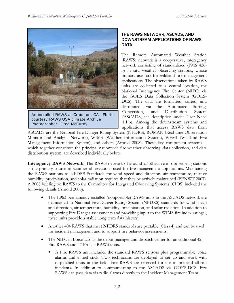
Wildland Fire Weather: Multi-agency Capabilities Portfolio 2. Functional Area 1
2-2
An installed RAWS at Cranston, CA. Photo courtesy RAWS USA climate Archive Photographer: Greg McCurdy
THE RAWS NETWORK, ASCADS, AND DOWNSTREAM APPLICATIONS OF RAWS DATA
The Remote Automated Weather Station (RAWS) network is a cooperative, interagency network consisting of standardized (PMS 426-3) in situ weather observing stations, whose primary uses are for wildland fire management applications. The observations taken by RAWS units are collected to a central location, the National Interagency Fire Center (NIFC) via the GOES Data Collection System (GOES-DCS). The data are formatted, sorted, and distributed via the Automated Sorting, Conversion, and Distribution System (ASCADS; see description under User Need 1.1.b). Among the downstream systems and applications that access RAWS data from
ASCADS are the National Fire Danger Rating System (NFDRS), ROMAN (Real-time Observation Monitor and Analysis Network), WIMS (Weather Information System), WFMI (Wildland Fire Management Information System), and others (Arnold 2008). These key component systems—which together constitute the principal nationwide fire weather observing, data collection, and data distribution system, are described individually below. Interagency RAWS Network. The RAWS network of around 2,450 active in situ sensing stations is the primary source of weather observations used for fire management applications. Maintaining the RAWS stations to NFDRS Standards for wind speed and direction, air temperature, relative humidity, precipitation, and solar radiation requires that they be actively maintained (FENWT 2007). A 2008 briefing on RAWS to the Committee for Integrated Observing Systems (CIOS) included the following details (Arnold 2008):
The 1,963 permanently installed (nonportable) RAWS units in the ASCADS network are maintained to National Fire Danger Rating System (NFDRS) standards for wind speed and direction, air temperature, humidity, precipitation, and solar radiation. In addition to supporting Fire Danger assessments and providing input to the WIMS fire index ratings , these units provide a stable, long term data history.
Another 404 RAWS that meet NFDRS standards are portable (Class 4) and can be used for incident management and to support fire behavior assessments.
The NIFC in Boise acts as the depot manager and dispatch center for an additional 42 Fire RAWS and 47 Project RAWS units.
A Fire RAWS unit includes the standard RAWS sensors plus programmable voice alarms and a fuel stick. Two technicians are deployed to set up and work with dispatched units in the field. Fire RAWS are reserved for use in fire and all-risk incidents. In addition to communicating to the ASCADS via GOES-DCS, Fire RAWS can pass data via radio alarms directly to the Incident Management Team.
Wildland Fire Weather: Multi-agency Capabilities Portfolio 2. Functional Area 1
2-3
A RAWS Network Analysis Study was initiated by FENWT to estimate the optimal distribution of RAWS stations in order to provide recommendations that meet agency needs in the future by supporting point and gridded applications for fire weather forecasting, fire behavior prediction, fire danger rating, smoke management, and fire program analysis. This study will leverage the existing capabilities, resources, and experience conducting applied research in the Department of Meteorology at the University of Utah and the Desert Research Institute (DRI) Program for Climate, Ecosystem and Fire Applications (CEFA) to examine the impact of the RAWS network in a manner relevant to fire management. This analysis is scheduled to be completed during the summer of 2009. NIFC Remote Sensing/Fire Weather Support Unit (RSFWSU). The RSFWSU supports the RAWS network through station maintenance and weather data distribution services. Of the roughly 2,450 RAWS units throughout the United States, the RSFWSU provides 85% of total depot maintenance and 21% of the field services. The RSFWSU also caches and supports dispatch of the portable Fire RAWS units to wildland fire and all-risk incidents and dispatch of Project RAWS for research, resource assessments, burned area rehabilitation, and other non-emergency uses relevant to fire management. The RSFWSU program is mature and fully implemented. Future growth depends on definition of the ultimate RAWS network size. The RSFWSU recently underwent an OMB Circular A-76 Competitive Sourcing study, which resulted in establishing it as a Most Efficient Organization and validating its continuing function within the federal government. Current improvements for this program include updating software support for maintenance tracking functions as well as the central data collection and distribution application. ROMAN. ROMAN is currently the system of choice for wildland fire management field users who want to access real-time or near real-time weather data. The ROMAN website (http://raws.wrh.noaa/gov/roman/) provides password-free access to real-time observations from RAWS and from the observing networks of the MesoWest system. Data can be accessed in either tabular or spatial formats. When the ROMAN project began in 2001, an important goal was to provide easy access data and products from RAWS and other observing networks in a consolidated, wildland-fire-relevant data format. According to FENWT, ROMAN has become the “face” of the RAWS network to the wildland fire user community (FENWT 2007). ROMAN was developed by GACC meteorologists in coordination with the University of Utah. The format of this web site is concise and emphasizes weather elements most pertinent to fire weather and fire danger. ROMAN provides the wildland fire community with a quick and thorough view of available fire weather elements, without fumbling through a maze of websites with differing observation networks. The data available in ROMAN support fire behavior, fire weather observations, and fire weather forecasting activities. ROMAN offers a higher spatial resolution than other weather data access portals and includes data from other mesonets. A key feature of ROMAN is that data from multiple mesonets (the MesoWest system) are presented to users in a standard format. ROMAN currently receives its RAWS data from ASCADS. The ROMAN application now resides on servers at the NOAA/NWS Western Region Headquarters servers in Salt Lake City, Utah. The software is supported by staff at the University of Utah under contract with the USFS. ROMAN was initially supported by BLM-Utah, with USFS
Wildland Fire Weather: Multi-agency Capabilities Portfolio 2. Functional Area 1
2-4
providing funding for FY 2006 and FY 2007. The $60K of funding for ROMAN in FY 2007 supported just the operations and maintenance (O&M) activities necessary to keep the system running. NWS provides an in-kind contribution as IT support cost sharing (e.g., server housing, communications). Further development of ROMAN capability is occurring within the MesoWest R&D program, but MesoWest is not set up to support an operational system like ROMAN (FENWT 2007). Continuation of the ROMAN software support contract from year to year is subject to authorization and the confirmed availability of funds. In addition to the conditional funding stream for ROMAN, there are improvements required to stabilize ROMAN to avoid software failures and to meet critical user needs. The NWCG Fire Environment Working Team (FENWT) RAWS/ROMAN Study Report found that timely access to accurate weather data is critical to the success of wildland fire management and establishes the importance of fire weather data and its timely delivery to fire personnel at all organizational levels (FENWT 2007). This report refers to the finding in the OFCM’s NWFWNA user needs summary that timely, accurate fire weather data are critical to the success of fire suppression and other emergency efforts (OFCM 2007). Both the FENWT Report and NWFWNA determined that there are significant risks in the current data delivery systems for ROMAN. The FENWT Report drew the following conclusion:
The functionality provided by ROMAN must be fully supported. It is a vital part of our fire weather data access infrastructure. As the implementation of NWFEA [the National Wildland Fire Enterprise Architecture] unfolds, we should find ways to link, combine, or merge our other data access systems while maintaining the functionality of ROMAN.
FENWT recommended that ROMAN be fully supported and sanctioned as a mission-critical data access system for NWCG and that programmatic funding be provided for project management, operations and maintenance, and ROMAN software upgrading. To address the recommendations from the RAWS/ROMAN Study Report, the NWCG Executive Board requested a business case analysis including a range of alternatives and associated costs. The Business Case was completed in January 2009 and, as of February 2009, was in review prior to presentation to the NWCG Executive Board for a decision. Weather Information Management System (WIMS). This password-protected information management system has been the primary processor for making RAWS data accessible nationwide. It provides access to hourly and daily RAWS data for the previous 18 months. WIMS users can manually review daily data for quality and then archive the data into the National Interagency Fire Management Integrated Database (NIFMID) for future NFDRS analyses. For general description of NIFMID, see “FAMWEB, WIMS, and NIFMID” under User Need 1.1.b. As of October 2007, WIMS was the only application where users could edit RAWS data and manage the NFDRS model (FENWT 2007). Wildland Fire Management Information (WFMI) website of BLM/NIFC. This password-protected site includes modules for weather data from the RAWS network, NLDN lightning data, and fire reporting. According to FENWT (2007), the entire site is password-protected because the NLDN data are proprietary. The RAWS weather data module provides hourly weather observations from RAWS stations reporting through GOES-DCS and ASCADS.
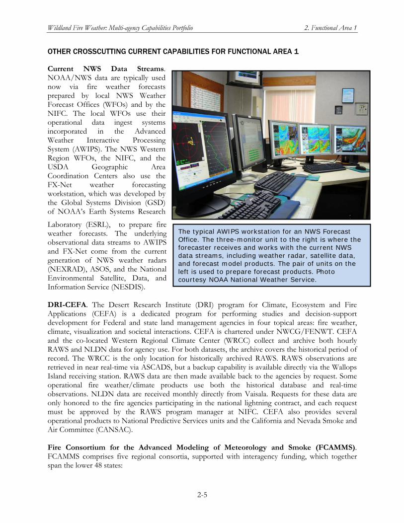
Wildland Fire Weather: Multi-agency Capabilities Portfolio 2. Functional Area 1
2-5
OTHER CROSSCUTTING CURRENT CAPABILITIES FOR FUNCTIONAL AREA 1
Current NWS Data Streams. NOAA/NWS data are typically used now via fire weather forecasts prepared by local NWS Weather Forecast Offices (WFOs) and by the NIFC. The local WFOs use their operational data ingest systems incorporated in the Advanced Weather Interactive Processing System (AWIPS). The NWS Western Region WFOs, the NIFC, and the USDA Geographic Area Coordination Centers also use the FX-Net weather forecasting workstation, which was developed by the Global Systems Division (GSD) of NOAA’s Earth Systems Research
Laboratory (ESRL), to prepare fire weather forecasts. The underlying observational data streams to AWIPS and FX-Net come from the current generation of NWS weather radars (NEXRAD), ASOS, and the National Environmental Satellite, Data, and Information Service (NESDIS). DRI-CEFA. The Desert Research Institute (DRI) program for Climate, Ecosystem and Fire Applications (CEFA) is a dedicated program for performing studies and decision-support development for Federal and state land management agencies in four topical areas: fire weather, climate, visualization and societal interactions. CEFA is chartered under NWCG/FENWT. CEFA and the co-located Western Regional Climate Center (WRCC) collect and archive both hourly RAWS and NLDN data for agency use. For both datasets, the archive covers the historical period of record. The WRCC is the only location for historically archived RAWS. RAWS observations are retrieved in near real-time via ASCADS, but a backup capability is available directly via the Wallops Island receiving station. RAWS data are then made available back to the agencies by request. Some operational fire weather/climate products use both the historical database and real-time observations. NLDN data are received monthly directly from Vaisala. Requests for these data are only honored to the fire agencies participating in the national lightning contract, and each request must be approved by the RAWS program manager at NIFC. CEFA also provides several operational products to National Predictive Services units and the California and Nevada Smoke and Air Committee (CANSAC). Fire Consortium for the Advanced Modeling of Meteorology and Smoke (FCAMMS). FCAMMS comprises five regional consortia, supported with interagency funding, which together span the lower 48 states:
The typical AWIPS workstation for an NWS Forecast Office. The three-monitor unit to the right is where the forecaster receives and works with the current NWS data streams, including weather radar, satellite data, and forecast model products. The pair of units on the left is used to prepare forecast products. Photo courtesy NOAA National Weather Service.
Wildland Fire Weather: Multi-agency Capabilities Portfolio 2. Functional Area 1
2-6
Northwest Regional Modeling Consortium (NWRMC)/AirFire in Seattle, Washington
(CANSAC, located at DRI in Reno, Nevada, and the Riverside Fire Lab in Riverside, California
Rocky Mountain Center for Advanced Modeling of Meteorology and Smoke (RMC) and the Forest Service Remote Sensing Laboratory in Fort Collins, Colorado
Southern High Resolution Modeling Center (SHRMC) at the University of Georgia
Eastern Area Modeling Consortium (EAMC) at the Forest Service’s North Central Research Station in East Lansing, Michigan
The overall goal of FCAMMS is to study the atmospheric component of the fire environment across space and time scales, and its interaction with other components, using a balance of basic and applied science to provide tools to the field now, and to create a basis for future science applications. The regional consortia bring scientists and land managers together to create a focused research program and promote science delivery. The regional structure of the FCAMMS allows better coordination with land management needs and locally unique fire problems, but the science developed by the FCAMMS is globally relevant and shared among the regions as needed and appropriate. Core FCAMMS areas include the BlueSky smoke modeling framework; use of mesoscale models for prediction of fire weather (NFDRS, Haines Index, dry lightning, BEHAVE input data, and more); seasonal fire forecasting; fire-atmosphere interactions; remote sensing; plume model development; smoke transport, dispersion, and the air quality effects of wildland and prescribed fires; user based decision-support. For this functional area, FCAMMS provides atmospheric models from local to global scales for a variety of purposes, such as fire behavior modeling (sub-kilometer scale) to seasonal fire climate forecasting. National Lightning Detection Network (NLDN). This network of more than 100 ground-based lightning sensors is owned and operated by Vaisala. The sensors detect the electromagnetic signal signature of a cloud-to-ground lightning strike and send their raw data, via satellite telecommuni-cations, to the Network Control Center in Tucson, Arizona. The computer-based central analyzers at the NLDN control center process this information to derive the location, time, polarity, and amplitude of each lightning ground strike. This information is then disseminated to public and private sector customers, including Federal agencies (Vaisala 2008). For the wildland fire community, funding to obtain NLDN data is through the BLM, which transfers the annual funding required ($688,000) to NOAA/NWS for payment to Vaisala. Although Vaisala offers NLDN data 24 hours a day, 365 days a year (Vaisala 2008), the BLM program is not funded or staffed to provide 24/7 data dissemination services. Next-Generation Radar (NEXRAD) Weather Radar Network. NEXRAD is a network of 159 high-resolution Doppler weather radars operated by the National Weather Service, an agency of the National Oceanic and Atmospheric Administration (NOAA) within the United States Department of Commerce. Its technical name is WSR-88D, which stands for Weather Surveillance Radar, 1988, Doppler. NEXRAD detects precipitation and atmospheric movement or wind. It returns data which when processed can be displayed in a mosaic map which shows patterns of precipitation and its movement. The radar system operates in two basic modes, selectable by the operator — a slow-scanning clear-air mode for analyzing air movements when there is little or no activity in the area,
Wildland Fire Weather: Multi-agency Capabilities Portfolio 2. Functional Area 1
2-7
and a precipitation mode, with a faster scan for tracking active weather. NEXRAD has an increased emphasis on automation, including the use of algorithms and automated volume scans. NOAA MADIS. The Meteorological Assimilation Data Ingest System (MADIS) was developed and is currently supported by the ESRL/GSD. The following information is from the MADIS website: http://madis.noaa.gov/. MADIS provides value-added data from a wide range of observing systems and platforms for the purpose of improving weather forecasting, by providing support for data assimilation, numerical weather prediction, and other hydrometeorological applications. For purposes of wildland fire weather observations and mesoscale to mesoscale atmospheric characterizations, the following data sources already available through MADIS are of particular interest:
Datasets from ASOS (Automated Surface Observing System) and AWOS (Automated Weather Observing Stations) maintained by NOAA/NWS, Federal Aviation Agency, and the Department of Defense (DoD).
NWS Cooperative Observer Network
57 surface-observing mesonets located around the United States, including the Interagency RAWS network
GOES satellite winds (operational 3-hour and experimental 1-hour data)
NOAA POES sounding and radiance data MADIS provides quality control data for the observational datasets in its database. Observations are stored in the ESRL/GSD database with a series of flags indicating the quality of the observation from a variety of perspectives (e.g., temporal consistency and spatial consistency), or more precisely, a series of flags indicating the results of various quality control checks. Users of MADIS can inspect these flags and decide whether or not to ingest an observation. MADIS subscribers also can access real-time gridded surface analyses that assimilate all of the MADIS surface datasets (including the highly-dense integrated mesonet data). The grids are produced by the Rapid Update Cycle (RUC) Surface Assimilation System (RSAS) that runs at NOAA/ESRL/GSD. RSAS incorporates a 15-km grid stretching from Alaska in the north to Central America in the south and also covering significant oceanic areas. The RSAS grids are valid at the top of each hour, and are updated every 15 minutes. MADIS as the Enhanced Successor to ROMAN. The NWCG approved a recommendation from the 2007 FENWT study of RAWS and ROMAN to proceed with an enhanced ROMAN capability. One enhancement option was to work with NWS on migrating the current ROMAN functionality to the Meteorological Assimilation Data Ingest System (MADIS) of the NOAA Earth System Research Laboratory (ERSL). MADIS would thus become the future source of RAWS data, as well as wildland fire weather data from other observation networks and gridded products. The FENWT also recommended looking for ways to “link, combine, or merge” the other RAWS data access systems with MADIS, including ASCADS, WIMS, WFAS, WFMI, and WRCC. The FENWT study explicitly referenced the NWFWNA user needs summary (OFCM 2007) as one of the bases for its conclusions and recommendations.
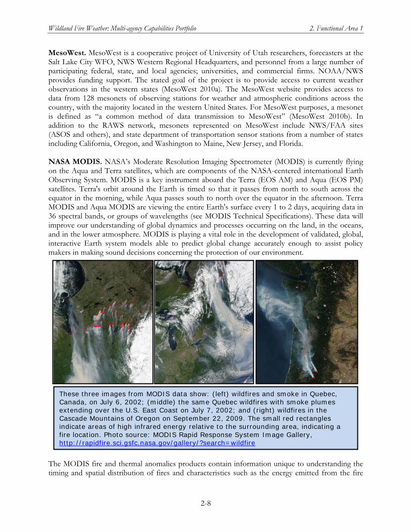
Wildland Fire Weather: Multi-agency Capabilities Portfolio 2. Functional Area 1
2-8
MesoWest. MesoWest is a cooperative project of University of Utah researchers, forecasters at the Salt Lake City WFO, NWS Western Regional Headquarters, and personnel from a large number of participating federal, state, and local agencies; universities, and commercial firms. NOAA/NWS provides funding support. The stated goal of the project is to provide access to current weather observations in the western states (MesoWest 2010a). The MesoWest website provides access to data from 128 mesonets of observing stations for weather and atmospheric conditions across the country, with the majority located in the western United States. For MesoWest purposes, a mesonet is defined as “a common method of data transmission to MesoWest” (MesoWest 2010b). In addition to the RAWS network, mesonets represented on MesoWest include NWS/FAA sites (ASOS and others), and state department of transportation sensor stations from a number of states including California, Oregon, and Washington to Maine, New Jersey, and Florida. NASA MODIS. NASA’s Moderate Resolution Imaging Spectrometer (MODIS) is currently flying on the Aqua and Terra satellites, which are components of the NASA-centered international Earth Observing System. MODIS is a key instrument aboard the Terra (EOS AM) and Aqua (EOS PM) satellites. Terra's orbit around the Earth is timed so that it passes from north to south across the equator in the morning, while Aqua passes south to north over the equator in the afternoon. Terra MODIS and Aqua MODIS are viewing the entire Earth's surface every 1 to 2 days, acquiring data in 36 spectral bands, or groups of wavelengths (see MODIS Technical Specifications). These data will improve our understanding of global dynamics and processes occurring on the land, in the oceans, and in the lower atmosphere. MODIS is playing a vital role in the development of validated, global, interactive Earth system models able to predict global change accurately enough to assist policy makers in making sound decisions concerning the protection of our environment.
The MODIS fire and thermal anomalies products contain information unique to understanding the timing and spatial distribution of fires and characteristics such as the energy emitted from the fire
These three images from MODIS data show: (left) wildfires and smoke in Quebec, Canada, on July 6, 2002; (middle) the same Quebec wildfires with smoke plumes extending over the U.S. East Coast on July 7, 2002; and (right) wildfires in the Cascade Mountains of Oregon on September 22, 2009. The small red rectangles indicate areas of high infrared energy relative to the surrounding area, indicating a fire location. Photo source: MODIS Rapid Response System Image Gallery, http://rapidfire.sci.gsfc.nasa.gov/gallery/?search=wildfire
Wildland Fire Weather: Multi-agency Capabilities Portfolio 2. Functional Area 1
2-9
and is available for both day and night periods. Temporal composites include an eight-day and monthly day and night fire occurrence aggregation and a summary of the number of fires in classes related to the strength of the fire. The MODIS Standard Fire products will provide an important contribution to the NASA Land Use and Land Cover Program and the International Global Observation of Forest Cover Project. The NASA MODIS Rapid Response System provides global wildland fire imagery, within a few hours of being collected, to the USFS and the international fire management community. The USFS Remote Sensing Applications Center (RSAC) in Salt Lake City uses the MODIS data in generating regional maps for U.S. fire managers. NASA MODIS/ASTER Airborne Simulator. The primary objective of the MASTER activity is to support the ASTER and MODIS instrument teams in algorithm development, calibration, and validation. The MODIS/ASTER (MASTER) airborne simulator is a joint development involving the Airborne Sensor Facility at the Ames Research Center, the Jet Propulsion Laboratory and the EROS Data Center. MASTER is essentially a clone of the MODIS Airborne Simulator (MAS), with changes in the spectral band positions in order to better simulate both ASTER and MODIS. MASTER has flown on the following piloted aircraft: Kingair Beachcraft B200 (DOE aircraft), Sky Research Cessna Caravan C208, NASA DC-8, NASA ER-2, and NASA WB-57. NASA has also flown MASTER on UASs over wildland fires in western states in support of firefighting operations. NASA has described these flights as important scientifically, as well as providing tactical support to firefighters. NICC/GACC Predictive Services Units. Under the interagency Predictive Services Program, a Predictive Services unit is located at the NICC and each of the nine GACCs. In each unit, meteorologists with fire weather expertise team with a fire management intelligence specialist and often (especially during fire season) a fire behavior specialist. Current products and services produced by the NICC and GACC units are specified in the Predictive Services Handbook (NPSS 2009). The 2009 update of the Handbook also contains an updated version of the Predictive Services Strategic Plan. See also the section in Chapter 1 on the role of the National Predictive Services Program in the multi-agency coordinating structure. Oklahoma Mesonet and OK-FIRE. This statewide mesonet, managed by the University of Oklahoma and Oklahoma State University, has at least one sensor station in every Oklahoma county (119 stations). It is a primary source of weather data for Oklahoma users involved in transportation, law enforcement, severe weather, and fire management. OK-FIRE is a program funded by the Joint Fire Science Program (see Crosscutting Capabilities for Functional Area 2) to use Oklahoma Mesonet data in fire-related applications. The 2007 RAWS/ROMAN report cited the OK-FIRE website as “a good example of providing a display of data for many different applications in one place…” including fire weather products, interactive, zoomable maps of fire danger and smoke-dispersion, and site-specific data charts and tables. Satellite Based Observing Systems. Currently, NOAA/NESDIS operationally supports two geostationary (GOES-East and GOES-West) and two polar orbiting (NOAA-17 and NOAA-18) satellites. GOES-East and GOES-West provide routine imaging at 15 minute intervals with more frequent 5 minute Rapid Scan Operations available upon request. Imagery is available to users within minutes of data ingest. The polar orbiting spacecraft provide higher spatial resolution imaging but data are less frequent and available to users within about an hour of overpass. All told, due to
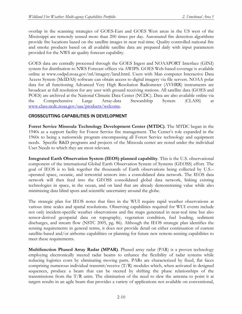
Wildland Fire Weather: Multi-agency Capabilities Portfolio 2. Functional Area 1
2-10
overlap in the scanning strategies of GOES-East and GOES West areas in the US west of the Mississippi are remotely sensed more than 200 times per day. Automated fire detection algorithms provide fire locations based on the satellite images in near real-time. Quality controlled national fire and smoke products based on all available satellite data are prepared daily with input parameters provided for the NWS air quality forecast capability. GOES data are centrally processed through the GOES Ingest and NOAAPORT Interface (GINI) system for distribution to NWS Forecast offices via AWIPS. GOES Web-based coverage is available online at www.osdpd.noaa.gov/ml/imagery/land.html. Users with Man computer Interactive Data Access System (McIDAS) software can obtain access to digital imagery via file servers. NOAA polar data for all functioning Advanced Very High Resolution Radiometer (AVHRR) instruments are broadcast at full resolution for any user with ground receiving stations. All satellite data (GOES and POES) are archived at the National Climatic Data Center (NCDC). Data are also available online via the Comprehensive Large Array-data Stewardship System (CLASS) at www.class.ncdc.noaa.gov/saa/products/welcome.
CROSSCUTTING CAPABILITIES IN DEVELOPMENT
Forest Service Missoula Technology Development Center (MTDC). The MTDC began in the 1940s as a support facility for Forest Service fire management. The Center’s role expanded in the 1960s to being a nationwide program encompassing all Forest Service technology and equipment needs. Specific R&D programs and projects of the Missoula center are noted under the individual User Needs to which they are most relevant. Integrated Earth Observation System (IEOS) planned capability. This is the U.S. observational component of the international Global Earth Observation System of Systems (GEOSS) effort. The goal of IEOS is to link together the thousands of Earth observations being collected by U.S.–operated space, oceanic, and terrestrial sensors into a consolidated data network. The IEOS data network will then feed into the GEOSS consolidated global data network, linking existing technologies in space, in the ocean, and on land that are already demonstrating value while also minimizing data blind spots and scientific uncertainty around the globe. The strategic plan for IEOS notes that fires in the WUI require rapid weather observations at various time scales and spatial resolutions. Observing capabilities required for WUI events include not only incident-specific weather observations and fire maps generated in near-real time but also sensor-derived geospatial data on topography, vegetation condition, fuel loading, sediment discharges, and stream flow (NSTC 2005, pg. 86). Although the IEOS strategic plan identifies the sensing requirements in general terms, it does not provide detail on either continuation of current satellite-based and/or airborne capabilities or planning for future new remote-sensing capabilities to meet these requirements. Multifunction Phased Array Radar (MPAR). Phased array radar (PAR) is a proven technology employing electronically steered radar beams to enhance the flexibility of radar systems while reducing logistics costs by eliminating moving parts. PARs are characterized by fixed, flat faces comprising numerous individual transmit/receive (T/R) modules which, when activated in designed sequences, produce a beam that can be steered by shifting the phase relationships of the transmissions from the T/R units. The elimination of the need to slew the antenna to point it at targets results in an agile beam that provides a variety of applications not available on conventional,
Wildland Fire Weather: Multi-agency Capabilities Portfolio 2. Functional Area 1
2-11
mechanically rotating radars. MPAR is a concept employing a PAR to simultaneously address a combination of requirements for several missions using the same radar platform. Those missions include standard weather applications (severe weather, hydrology, etc.), air terminal weather applications (downburst, wind shear), air traffic management, and defense and homeland security. Other potential enhanced applications include bird hazard detection and detection and wind field determination support for wildland fires, volcanic ash, and accidental and terrorist nuclear, biological, chemical events. Multifunctionality is achieved by a combination of sharing the data from the radar and, more importantly, sharing the time that the beam is available—exploiting the agility of the beam to apply it to the different functions in small, discrete time increments. The ability of PAR systems to perform air surveillance for air traffic management and national and homeland security has been proven by operational systems that have been employed for decades by the department of defense. A risk-reduction program is underway to verify that PARs can meet weather radar requirements (particularly the ability to perform in dual linear polarization mode), demonstrate that the beams are sufficiently agile to perform all required functions simultaneously, and the cost of PARs can be reduced through the use of off-the-shelf technologies and advanced architectures.
National Science Foundation (NSF) Research Projects. The general description of NSF research grants and a summary of recent grants relevant to two or more user needs are included under Crosscutting Capabilities in Development for Functional Area 2. National Wildland Fire Enterprise Architecture (NWFEA). Managed by the NWCG through the NIFC, the NWFEA Program is intended to provide “the framework to better manage interagency wildland fire initiatives.” (NWCG 2008a). The draft NFEA Blueprint, released for agency review in July 2008, includes a number of recommendations relevant to NWFWNNA User
This panorama illustrates MPAR coverage capabilities over a full 360o in azimuth and 15o in elevation. The radar adaptively covers and observes the whole hemisphere (i.e., up to 90o in elevation). Illustrated functions—clockwise from left—are a long-dwell scan through a region of smoke from a wildland fire; full-volume continuous scan through the planetary boundary layer (clear air) for mapping winds; detection and tracking of aircraft, including non-cooperative targets; full-volume continuous scan through a supercell storm; and long-dwell scan through a region of a potential tornado.
Wildland Fire Weather: Multi-agency Capabilities Portfolio 2. Functional Area 1
2-12
Needs (NWCG 2008b). The NWFEA Blueprint also includes specific action items, with estimated completion dates, for implementing its recommendations. See the specific NWFEA need section for details of the NWFEA Blueprint recommendations and action items relevant to that need. Nationwide Network of Observing Mesonets. The 2009 National Research Council report, Observing Weather and Climate from the Ground Up: A Nationwide Network of Networks, documents the findings and recommendations of an expert committee tasked to address the need for and development of a national network of mesoscale meteorological observational networks that can meet multiple national needs. Federal agencies and state and local governments, often in partnerships with universities and/or private-sector companies, have set up observing systems across the country, each of which constitutes a local or regional mesonet of varying capabilities but with no overall national strategy or standards. The report identified observations that are vital to the nation’s well-being by providing the data foundation to improve services of substantial societal and economic value. The study committee concluded that current mesonet observing capabilities lack vertical coverage of the atmosphere, adequate monitoring of air quality and chemical constituents, solar radiation measurements, and measurements of soil moisture and temperature profiles:
…[O]verall, the status of U.S. surface meteorological observation capabilities is…driven mainly by local needs without adequate coordination. While other providers act locally to satisfy particular regional monitoring needs, the federal government is unique in its capacity to act strategically and globally in the national interest. An overarching national strategy is needed to integrate disparate systems from which far greater benefit could be derived and to define the additional observations required to achieve a true multi-purpose network that is national in scope, thereby fully enabling mesoscale numerical weather prediction and other applications. (NRC 2009, pg. 3)
The Office of the Federal Coordinator for Meteorological Services and Supporting Research (OFCM), through its Committee for Integrated Observing Systems (CIOS), is working with the federal agencies to establish the Network of Weather and Climate Observing Networks (NOWCON). The goal of the NOWCON is to develop a federal strategy to integrate disparate observing systems to meet multiple national needs in a cost-effective manner and to provide an organizational framework for coordination, integration and interoperability. The Interagency RAWS network is one of the set of observing networks being considered by the CIOS as it works toward implementing the NOWCON. New NOAA/NWS data streams. Potential improvements to remotely sensed and in situ routine environmental data include a new generation of weather radars, particularly a multifunction phased array radar (MPAR) system, and the National Polar-orbiting Operational Environmental Satellite System (NPOESS) including the NPOESS Preparatory Project (NPP). Additionally, GOES-R, the next generation of GOES satellites, will provide improved spatial and temporal coverage.
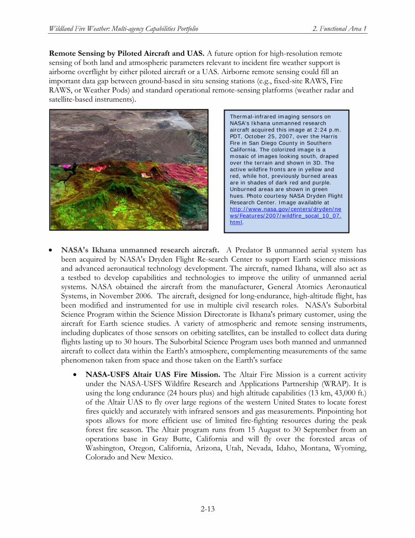
Wildland Fire Weather: Multi-agency Capabilities Portfolio 2. Functional Area 1
2-13
Remote Sensing by Piloted Aircraft and UAS. A future option for high-resolution remote sensing of both land and atmospheric parameters relevant to incident fire weather support is airborne overflight by either piloted aircraft or a UAS. Airborne remote sensing could fill an important data gap between ground-based in situ sensing stations (e.g., fixed-site RAWS, Fire RAWS, or Weather Pods) and standard operational remote-sensing platforms (weather radar and satellite-based instruments).
NASA's Ikhana unmanned research aircraft. A Predator B unmanned aerial system has been acquired by NASA's Dryden Flight Re-search Center to support Earth science missions and advanced aeronautical technology development. The aircraft, named Ikhana, will also act as a testbed to develop capabilities and technologies to improve the utility of unmanned aerial systems. NASA obtained the aircraft from the manufacturer, General Atomics Aeronautical Systems, in November 2006. The aircraft, designed for long-endurance, high-altitude flight, has been modified and instrumented for use in multiple civil research roles. NASA's Suborbital Science Program within the Science Mission Directorate is Ikhana's primary customer, using the aircraft for Earth science studies. A variety of atmospheric and remote sensing instruments, including duplicates of those sensors on orbiting satellites, can be installed to collect data during flights lasting up to 30 hours. The Suborbital Science Program uses both manned and unmanned aircraft to collect data within the Earth's atmosphere, complementing measurements of the same phenomenon taken from space and those taken on the Earth's surface
NASA-USFS Altair UAS Fire Mission. The Altair Fire Mission is a current activity under the NASA-USFS Wildfire Research and Applications Partnership (WRAP). It is using the long endurance (24 hours plus) and high altitude capabilities (13 km, 43,000 ft.) of the Altair UAS to fly over large regions of the western United States to locate forest fires quickly and accurately with infrared sensors and gas measurements. Pinpointing hot spots allows for more efficient use of limited fire-fighting resources during the peak forest fire season. The Altair program runs from 15 August to 30 September from an operations base in Gray Butte, California and will fly over the forested areas of Washington, Oregon, California, Arizona, Utah, Nevada, Idaho, Montana, Wyoming, Colorado and New Mexico.
Thermal-infrared imaging sensors on NASA's Ikhana unmanned research aircraft acquired this image at 2:24 p.m. PDT, October 25, 2007, over the Harris Fire in San Diego County in Southern California. The colorized image is a mosaic of images looking south, draped over the terrain and shown in 3D. The active wildfire fronts are in yellow and red, while hot, previously burned areas are in shades of dark red and purple. Unburned areas are shown in green hues. Photo courtesy NASA Dryden Flight Research Center. Image available at http://www.nasa.gov/centers/dryden/news/Features/2007/wildfire_socal_10_07.html.
Wildland Fire Weather: Multi-agency Capabilities Portfolio 2. Functional Area 1
2-14
The ESRL UCATS instrument (Unmanned aircraft systems Chromatograph for Atmospheric Trace Species), which is flying on Altair for this mission, has been enhanced since its last use in the NOAA UAS Demonstration of 2005 to now measure water vapor with a tunable diode laser in addition to carbon monoxide, methane, nitrous oxide, and hydrogen. A new, more precise ultraviolet ozone photometer has also been installed on the Altair. All of the above mentioned trace gases are produced during forest fires. Additional measurement of the greenhouse gas, sulfur hexafluoride, released in the distribution of electricity will help identity polluted urban air masses not influenced by fires.
Wildfire Research and Applications Partnership (WRAP). The objectives of WRAP are to foster collaborative partnering between NASA and the U.S. Forest Service that will facilitate and demonstrate current and evolving technologies for increasing the information content and timeliness of earth resource data collected for wildland fire management applications. The agencies had been working collaboratively on parallel-track developments in fire imaging, but this initiative is the first major effort at formalizing and focusing wildfire science and applications between them. The outcomes of this collaborative effort will include creation of improved tools for wildfire decision support systems within the Forest Service and other fire mitigation and management entities. By partnering with the Forest Service, NASA can ensure that it provides the critical R&D elements necessary for successful implementation of a tactical wildfire disaster assessment and management system. For example, WRAP organized and founded a Tactical Fire Remote Sensing Advisory Committee (TFRSAC), composed of fire management practitioners, remote sensing scientists, GIS specialists, and industry and university affiliates, to formulate a tactical fire information gap analysis and prioritize development and transfer technologies related to the gaps identified. The TFRSAC defined four focus areas: develop and demonstrate improved airborne platform capabilities (manned aircraft and UAS), demonstrate new sensor capabilities for enhanced fire discrimination, demonstrate new data telemetry capabilities for real-time data distribution, and develop and demonstrate a collaborative decision environment capability to effect improvements to tactical fire decision support systems. Through the TFRSAC, the Forest Service, representing end users/customers, has helped to focus elements of R&D led by NASA. The Altair Fire Mission is one of the current WRAP R&D activities. See “Remote Sensing by Piloted Aircraft and UAS” in this section.
Need 1.1 Improvements in data management are needed to establish a comprehensive, nationally beneficial observing system to meet the needs of wildland fire weather users.
The wildland fire community has extensive requirements for timely, accurate, and complete observational data throughout the nation. These data are crucial to a multitude of decisions that wildland fire managers and land managers must make every day, for active fires, for fire planning, and for long-term planning. Furthermore, these data must include more than just the standard atmospheric measurements routinely taken by weather personnel. Observations must capture atmospheric conditions along with information such as ground cover type and quantity, fuels (fuel
Wildland Fire Weather: Multi-agency Capabilities Portfolio 2. Functional Area 1
2-15
type, moisture, temp), and soil conditions. And, observations are only useful if they’re complete, accurate, and if the resultant information is made available to the community as timely as possible. Wildland fire weather users must have robust access to trustworthy data, which means that these data must be collected, managed, and disseminated with great care and professionalism. While many observing systems currently exist, the corresponding data collection, management, and dissemination is mostly ad hoc, and requires a more comprehensive and overarching strategic plan. This plan must allow for integration of all observation activities, amongst all participating organizations, to become more unified allowing for more effective use of available resources while simultaneously providing more complete and accurate information to the wildland fire community and other interested users.
1.1.a A strategy for a complete, real-time, observationally based, gridded characterization of the current atmosphere needs to be developed and implemented based on an integrated set of all available in situ and remotely sensed environmental data.
DESCRIPTION OF THE NEED
Wildland fire weather users require an accurate and timely understanding of the present state of the atmosphere and earth surface as they evaluate and mitigate fire potential, as they respond to fire events, and as they restore areas damaged by fires. It is important to note that 41% of users indicated that their greatest observational data need was for more surface observations. Second to the need for more observing stations, 16% of users indicated a need for more lightning data. The third most stated need, at 11%, was the need for more satellite data. An important requirement of this data set is that data values would better represent conditions within regional areas. Current observing strategies provide users with data sparse observation points which do not adequately indicate the state of conditions away from the immediate vicinity of the observations. However, 74% of users stated a preference for observationally based data to be more representative of broad scale conditions rather than point specific. A properly developed integrated observing strategy would allow for more data points which are representative of broad scale areas. The fire community also requires that data be recorded, archived, and made available to the entire community to maximize its effectiveness as part of the climate record. While fire weather users make use of climate information for a variety of applications, 72% of the community considered climate data to be important to them. Data validation is required to ensure the integrity of data sets. Validation includes an evaluation of the accuracy and reliability of the data, given past performance by that station with respect to maintenance and other issues. Validation information must also be included in metadata fields to allow users to make appropriate use of the data. Automated validation is preferred to allow the data to be quickly evaluated and then made available for use by users and within varying data assimilation and representation systems. Furthermore, users require these data be made available in both high- and low-bandwidth options and in various formats such as standard graphics, GIS formats, PDA-supported formats, and text formats. The resulting data system needs to make full use of satellite and other remotely-sensed data.
Wildland Fire Weather: Multi-agency Capabilities Portfolio 2. Functional Area 1
2-16
Additionally, these data need to be made available openly to all levels of government and to public/private partners who assist with wildland fire response or planning activities... To achieve this objective, development and implementation of a complete integrated observing sensing strategy are required. This strategy must include detailed information on all observation sensor types and data elements, accounting for in situ data and remotely sensed data, to ensure achievement of a complete, integrated characterization of the atmosphere. This integrated system should consider use of all standard, fielded surface systems, including RAWS and the NWS Automated Surface Observing Systems (ASOS), which are commonly used by the fire weather community. Existing and planned mesonets should be included. New technologies must be leveraged, particularly remote sensing systems such as radars (e.g., multifunction phased array radar technology), atmospheric profilers, and airborne or space-based surveillance/sensing systems. This integrated observing system must support all fire weather data elements, especially those for critical atmospheric fire weather parameters at the surface and within the atmospheric boundary layer. An interagency approach is required to ensure that all suppliers, users, and beneficiaries work together to ensure consistent funding, development, implementation, and use of available systems. An example of the kind of characterization required by wildland fire weather users is the Four-Dimensional (4D) Data Cube concept planned for the U.S. Air Traffic/NextGen system, which seeks to provide a continually updated, authoritative picture of the atmosphere. This 4D Data Cube encompasses all three spatial dimensions along with time, represented as forecast interval. Furthermore, the data cube is continually updated to represent the present and future states of the atmosphere throughout a specified duration of forecast hours. Integrating fire weather data requirements into a similar system—or into the developing 4D Weather Data Cube system—would allow users to make informed decisions for any point in space, regardless of the observational or numerically modeled origins of the data representing conditions at that point over time. Because the 4D Weather Data Cube is conceived as a “single authoritative data source,” with data that meets rigorous quality control and data integrity requirements, it is likely to provide the larger-scale (synoptic and regional) data framework for observational and modeling characterizations of atmospheric conditions at the wildland fire incident/location scale. In the interest of providing timely (real time to near-real time) information to wildland fire managers and firefighters, these applications may not adhere to the “single authoritative source” constraints for finer-scale data within the larger framework.
CURRENT CAPABILITIES
DRI-CEFA. See general description under Crosscutting Capabilities for Functional Area 1. In addition to the operational products that CEFA provides to NPSG and CANSAC, DRI and the WRCC constitute an important expertise resource for contributing to a complete, real-time gridded characterization of the atmosphere that includes the data elements important to wildland fire management. FCAMMS. See general description under Crosscutting Capabilities for Functional Area 1. For User Need 1.1.a, the FCAMMS provides a robust resource for atmospheric models that could contribute to a complete, real-time gridded characterization of the current atmosphere. Interagency RAWS Network.. See general description under Crosscutting Capabilities for Functional Area 1. For fire weather applications, the observing data from the RAWS network will be
Wildland Fire Weather: Multi-agency Capabilities Portfolio 2. Functional Area 1
2-17
a core set of observation data from which a gridded characterization of the atmosphere would be derived. NASA MODIS Rapid Response System and MASTER. See general description of NASA Remote-Sensing R&D Platforms under Crosscutting Capabilities for Functional Area 1. The fire imagery from satellite-based MODIS currently provides routine regional maps for wildland fire managers even though these systems are technically experimental rather than operational systems. Airborne MASTER capability, either on piloted aircraft or UASs, represents an emerging capability for real-time support of wildland fire incident management—as well as all-hazard incident management generally. NLDN. See general description under Crosscutting Capabilities for Functional Area 1. Lightning ground strike data are another component of the environmental data that the wildland fire management community will require of a system that meets User Need 1.1.a. NOAA MADIS. See general description under Crosscutting Capabilities for Functional Area 1. Near-real-time and archival datasets from the RAWS network are among the observational datasets currently available in MADIS. MADIS’s inclusion of RSAS gridded model output is another feature that makes it relevant to User Need 1.1.a. NWS Data Streams. See general description under Crosscutting Capabilities for Functional Area 1. The NWS data streams, which include surface and satellite-based observations as well as gridded forecast products, provide essential in situ and remotely sensed environmental data on national and global scales. Satellite Based Observing Systems. See general description under Crosscutting Capabilities for Functional Area 1. Remotely sensed observations from the GOES and NOAA POES satellites are essential inputs for a gridded characterization of the current atmosphere.
CAPABILITIES IN DEVELOPMENT
4-Dimensional (4D) Weather Data Cube. A key component of the Next Generation Air Traffic System (NextGen) composed of critical weather elements observed and forecasted in both space (X, Y, Z) and time (T). The 4D Weather Data Cube will consist of real-time weather information to be made available to pilots, air traffic controllers, and forecasters alike through an efficient and secure data distribution system. The data will improve the decision making process, minimizing the adverse effects of weather conditions. The data elements associated with the 4D Weather Data Cube are currently undecided, but will undoubtedly include a set of high resolution grids that define aviation weather parameters such as aircraft icing and turbulence. Although the current focus of weather data elements to be included in the 4D Weather Data Cube are data elements essential to aviation weather, in principle it could be expanded to include the weather and fuel/soil moisture data elements important to wildland fire managers and fire weather forecasters. IEOS planned capability. See general description under Crosscutting Capabilities in Development for Functional Area 1. In principle, the long-term IEOS goal of a consolidated data network of Earth environmental observing sensors parallels the goal envisioned in need 1.1.a.
Wildland Fire Weather: Multi-agency Capabilities Portfolio 2. Functional Area 1
2-18
MPAR Network. See general description under Crosscutting Capabilities in Development for Functional Area 1. For User Need 1.1.a, MPAR represents the next major advance in ground-based large-area remote sensing using radar techniques. The simultaneous multifunction capability of MPAR units could help to acquire fire-related data elements that are not currently available for large regions of fire-prone terrain. Nationwide Network of Observing Mesonets. See general description under Crosscutting Capabilities in Development for Functional Area 1. A nationwide network of observing networks, particularly if it included RAWS, would be an obvious input to the gridded characterization of the atmosphere envisioned by User Need 1.1.a. NICC/GACC Predictive Services Units. See general description of Predictive Services under Crosscutting Capabilities for Functional Area 1. Predictive Services has been involved in recent studies of the RAWS network, the ROMAN system, and in the discussions of MADIS as a potential successor to RAWS. (See the subsection on “The RAWS network, ASCADS, and Downstream Applications of RAWS Data” and the entry for “MADIS as the Enhanced Successor to ROMAN” under Crosscutting Capabilities for Functional Area 1.) NWFEA. See general description under Crosscutting Capabilities in Development for Functional Area 1. Recommendation 3.4 of the draft NWFEA Blueprint, is to: “Establish a primary core national network of Remote Automatic Weather Stations (RAWS) designed to support point and gridded data applications.” Two action items to implement this recommendation are scheduled to begin in the fall of 2008 and be completed in April 2012 (NWCG 2008b, pp. 55, 57–68). New NOAA/NWS data streams. See general description under Crosscutting Capabilities in Development for Functional Area 1. Remote Sensing by Piloted Aircraft and UAS. See general description under Crosscutting Capabilities for Functional Area 1. A challenge for a gridded characterization of the current atmosphere is how to ingest and incorporate data from intermittent, mobile sensing stations such as those from aircraft and UASs. Nevertheless, these data sources could be critical to providing completeness of data coverage in hilly to mountainous terrain—where fires in the wildland-urban interface are a growing hazard.
CHALLENGES TO MEETING THE NEED
The challenges that must be addressed to resolve User Need 1.1.a include coordination, data, management, resources, science, and technology. An interagency strategy to achieve a nationwide, gridded atmospheric characterization at a sufficiently fine scale to be relevant to incident management and with all the needed parameters (see User Need 1.1.d) will require significant management involvement to pool resources and promote coordination. Close coordination is needed to ensure data are shared, data formats are consistent, and information on source data are provided, so that end users not only have access to the data but also have information on data source characteristics, data integrity, and data validation. For data at synoptic and regional scales, coordination with parallel efforts such as the 4D Aviation Weather Cube or the 5D Environmental Data Cloud will be essential to leverage limited resources for sensing, data processing, and data distribution.
Wildland Fire Weather: Multi-agency Capabilities Portfolio 2. Functional Area 1
2-19
Scientific advances are needed to support this continually updated environmental characterization, particularly to meet the need for real-time gridded atmospheric data at fire-incident scales. Continual and efficient integration of various types of data, measured from a variety of sources, into a single system and representation of the relevant environment is a challenge that encompasses capabilities for assimilation of time-variant observations and modeled outputs into a complete four-dimensional representation of the atmosphere. These output representations must include a broader range of atmospheric and land data, of varying formats, and update cycles, accessible from a common application interface. Scientific advances are crucial to providing an authoritative representation of the current and future states of the environment. Advances in numerical modeling, environmental parameterization, model selection, and stochastic modeling are needed to ensure that appropriate models are used for various diagnostic (current atmospheric conditions) and nowcast/forecast realizations (from less than an hour to several days later than the latest observations). Science advances are also needed to improve estimation and representation of forecast probabilities—essential for risk management decisions that weigh a range of possible scenarios. Management involvement is needed to develop and implement policies establishing domain authority and deciding how to integrate varying model solution into a definitive representation of the environment, as required by many agencies. Decisions also must be made regarding standardization of data formats, data representations, and setting priorities for data ingest. Management also needs to advocate for maximum release and availability of these data to all users. Trades must be made between firefighters’ need for current information at time scales of less than an hour and the desirability of a single authoritative data source. For example, a single authoritative data source, as advocated for the 4D Weather Cube concept in aviation weather, may be appropriate for synoptic and regional scales of a gridded atmospheric characterization, while the misoscale and finer characterizations are likely to draw on local data selections made “on the fly” by the Incident Meteorologist or local WFO forecaster. Substantial technology and infrastructure are needed to provide sufficient computer and communication system capability to support a robust integrated system. Pooling sufficient resources to address all these challenges is itself a major challenge. Given the complexity and difficulty of these challenges, meeting User Need 1.1.a will take considerable time. Hence, the Fire Weather Working Group considers this a long-term effort that requires immediate, substantial, and sustained investment of resources. 1.1.b A centralized means of reliably retrieving validated
observational data is needed.
DESCRIPTION OF THE NEED
Until a real-time, observationally based, gridded characterization of the current atmosphere and fuels information is available, as envisioned with the fulfillment of User Need 1.1.a, the fire community urgently needs robust access to timely and accurate observational data. In principle, the solution to this need will, in time, be incorporated into the gridded representation sought in User Need 1.1.a. However, it is vital to the wildland fire community that this need for reliable access to currently available, validated data be met well before the ultimate fulfillment of User Need 1.1.a.
Wildland Fire Weather: Multi-agency Capabilities Portfolio 2. Functional Area 1
2-20
Effective management of current and evolving operational data sets is critical to providing these data to the community. Data must be available from a centralized access point. Data available from this access point must include metadata information regarding data location, quality, and accuracy. This access point must allow users to quickly obtain data year-round and from any location, in either real-time or archived mode. Metadata must be universally provided to facilitate ease of information "tagging" and application. This centralized method must also fuse the best aspects currently available within ASCADS, WIMS, ROMAN, and the WRCC, to provide the functionality needed by the field. Coordination must be accomplished with the fire weather modeling community to ensure data are provided in a manner consistent with needs associated with rapidly evolving fire weather and fire spread modeling needs. Data must be made available in geographical information system (GIS) format to ensure ease of display in any format the user demands. Robust and redundant data archiving and retrieval are required to ensure rapid access and to prevent data access outages despite power or communications failures. Data archival must allow for complete archival of all station data, throughout the station’s recorded history to allow for effective evaluation and application of the data. Additionally, all data must be made available as rapidly as possible to enable users to benefit from time-sensitive conditions. This system must also be able to keep pace with changes in technology. Sensor placement and data collection should to be done with the intent of maximizing the long-term utility of the data for climatological applications. Data validation is also required to ensure the integrity of data sets. Validation includes an evaluation of the accuracy and reliability of the data, given past performance by that station with respect to maintenance and other issues. Validation information must also be included in metadata fields to allow users to make appropriate use of the data. Automated validation is preferred to allow the data to be quickly evaluated and then made available for use by users and within varying data assimilation and representation systems. Fire weather users also require better information about alternative data sources, to include remotely sensed data, sounders, aircraft data, unmanned aerial systems, etc., which could help them better understand current environmental conditions and forecast future conditions. For example, the user community expressed a desire for more frequent NWS upper air soundings in order to better evaluate fire threat conditions. However, similar observed (and forecast) information is available from other sources which could readily help characterize the fire threat conditions needed by fire weather users with more frequent updates than the present NWS upper air sounding system. A centralized data system would better enable users to access all available data.
CURRENT CAPABILITIES
ASCADS. See the subsection on “RAWS Network, ASCADS, and Downstream Applications of RAWS Data” under Crosscutting Capabilities for Functional Area 1. ASCADS distributes RAWS data to WFMI, WIMS, ROMAN, NWS, and WRCC. It also stores metadata on the RAWS stations in the network. According to the FENWT study on RAWS and ROMAN, ASCADS, which was
Wildland Fire Weather: Multi-agency Capabilities Portfolio 2. Functional Area 1
2-21
implemented in 1992 and is currently funded at $50K per year, is due for a review and system refresh or reengineering (FENWT 2007). Some of the ASCADS functionality related to RAWS station maintenance data is supposed to be taken over by the Computerized Maintenance Management System (CMMS). DRI-CEFA and the WRCC. See general description under Crosscutting Capabilities for Functional Area 1. CEFA and the WRCC play important roles in RAWS data archiving and retrieval, fire weather and climate product R&D, and other areas. This expertise can be drawn upon in working toward the single-source data access site requested by the user community in User Need 1.1.b. FAMWEB (Fire & Aviation Management Web Portal), WIMS, and NIFMID. These three database-related sites and systems represent the current state of practice in providing users with a centralized point of access to observation data. The FAMWEB website gives users access to a range of applications, tools, and services managed by the NWCG and participating agencies. WIMS, which is a password-protected database of RAWS data, is one of the applications hosted on FAMWEB. (See general description of WIMS under Crosscutting Capabilities for Functional Area 1.) NIFMID is the depository for daily NFDRS observations after they have been reviewed/revised by users with access to WIMS. It is currently accessed through a query program, KCFAST, which is available on FAMWEB. Access to KCFAST is password-protected. As of October 2007, the functionality provided by NIFMID and KCFAST was to be replaced by the FAMWEB Data Warehouse, which is described below under Potential Players (FENWT 2007). Interagency RAWS Network and ROMAN. See general description under Crosscutting Capabilities for Functional Area 1. The ROMAN network appears to be the current favorite of many RAWS data users in the wildland fire community and has the advantage, with respect to User Need 1.1.b, of not being password-protected. However, as discussed in the general descriptions for the RAWS network and MADIS, there are arguments for moving to an access interface with greater reliability and capability than ROMAN. As of February 2009, the NWCG Executive Board was considering recommendations from the 2007 FENWT report on RAWS and ROMAN. The board’s decision with respect to the issues and recommendations raised by that report will be key to the future of ROMAN in meeting User Need 1.1.b. NICC/GACC Predictive Services Units. See general description under Crosscutting Capabilities for Functional Area 1. Predictive Services staff and the NPSS are involved in current centralized sources of RAWS data and other mesonet observations data such as ROMAN and MesoWest. (See entries for ROMAN and MesoWest under Crosscutting Capabilities for Functional Area 1.) NLDN Lightning Ground-Stroke Data. See general description of the NLDN under Crosscutting Capabilities for Functional Area 1. The issue for User Need 1.1.b, as with other current observing data streams, is to make the NLDN-derived data products that are most useful to the wildland fire community readily accessible, at all times, to users in the community. MODIS Rapid Response System. See general description of the MODIS instrument and the Rapid Response System under NASA MODIS in the Crosscutting Capabilities section for Functional Area 1. With respect to User Need 1.1.b, the issue is providing MODIS fire and thermal imagery from one centralized site readily accessible to users in the wildland fire community under their typical operating conditions.
Wildland Fire Weather: Multi-agency Capabilities Portfolio 2. Functional Area 1
2-22
NASA MASTER. See general description under Crosscutting Capabilities for Functional Area 1. MASTER represents an emerging capability for advanced remote sensing targeted to high-priority wildland fire incidents and emergencies. With respect to User Need 1.1.b, the challenge is how (and whether) to make the datasets and data products from these nonroutine, targeted overflights available from a single source of validated observation data. NOAA MADIS. See general description under Crosscutting Capabilities for Functional Area 1. With respect to providing more reliable access to RAWS data, MADIS has been called the “enhanced ROMAN.” MADIS already has the advantage of including many other mesonet datasets in addition to RAWS data. However, MADIS access currently requires a subscription, and the suitability of the MADIS Internet-based interface for wildland fire users will have to be evaluated. Satellite Based Observing Systems. See general description under Crosscutting Capabilities for Functional Area 1. As with many other national meteorological data streams, GOES and NOAA POES data streams are readily available from their respective production dissemination sites on the Internet. However, User Need 1.1.b speaks to users’ need to get all the data they need from a single site/source that is easily accessible even in the field (and under firefighting conditions). Wildland Fire Management Information (WFMI) website of BLM/NIFC. See general description under Crosscutting Capabilities for Functional Area 1. Although WFMI provides hourly updates on RAWS data accessed via ASCADS, a major limitation with respect to User Need 1.1.b is that it must be password-protected because the NLDN data it contains are proprietary. FX-Net. The NWS Western Region tested the FX-Net thin client weather forecasting system (server and workstations) extensively during 2001 and during the 2002 Winter Olympic Games. It was then tested by Western Region IMETs during the 2002 fire season. In the winter of 2002–2003, FX-Net servers were procured for four NWS region—Western, Southern, Alaska and Pacific. In March 2003, the FX-Net portable workstations replaced the earlier Advanced Technology Meteorological Unit workstations nationwide for incident onsite forecasting by NWS IMETs. The FX-Net thin client workstation is currently the primary meteorological forecast workstation used at the NIFC and at the 11 GACCs in the continental United States and Alaska. Use of FX-Net at these centers began in November 2003. Special tools and fire-weather specific data sets have been added to the systems through 2009 to support the needs of fire weather meteorologists at these 12 centers.
CAPABILITIES IN DEVELOPMENT
Collection of Remote-Sensing Data and Product Distribution. The MODIS Rapid Response System illustrates the technological feasibility of transmitting, processing, and disseminating products useful to fire managers from satellite-based or airborne remote-sensing systems. (See general description of the NASA MODIS Rapid Response System under Crosscutting Capabilities for Functional Area 1.) Also, as noted in the Current Capabilities for User Need 1.1.b (see above), the WRAP project includes development of capabilities that will likely be relevant to the “one-stop data source” envisioned by this User Need. For example, WRAP’s products are to include creation of improved tools for wildfire decision support systems within the USFS and other fire mitigation and management agencies.
Wildland Fire Weather: Multi-agency Capabilities Portfolio 2. Functional Area 1
2-23
FAMWEB Data Warehouse (FDW). The stated objective of the FDW is to provide users with an Internet worldwide web interface to flexible reporting tools that can integrate data from a variety of fire, weather, and aviation databases. According to the FAMWEB website, the FDW will integrate fire and weather related data from the Fire Statistics (FIRESTAT) system, WIMS, National Interagency Situation Report (SIT/209), and Annual Wildfire Summary Report (AWSR). It will also provide access to Federal Excess Property Management System (FEPMIS) information. Information resources within the warehouse will be accessed through a web-based user interface allowing users, based on security roles, to view and print standard reports, create their own queries and reports, and conduct advanced analysis. A web-based geospatial tool will allow users to search and view data warehouse information through an interactive map display. As of March 2010, a test version of FDW was available to users with passwords on the FAMWEB’s FAMTEST webpage. The FDW is explicitly cited for support in Action Item 4.1.4 of the NFEA Blueprint (NWCG 2008, pg. 74). Integrated Earth Observation System (IEOS) planned capability. See general description under Crosscutting Capabilities in Development for Functional Area 1. As IEOS matures, the validated observing data it produces will likely need to be included in the centralized means of data retrieval envisioned by User Need 1.1.b. MADIS as the enhanced ROMAN. . See general description of the NOAA MADIS capability and the recommendation from the 2007 FENWT study under “Other Crosscutting Capabilities for Functional Area 1.” With respect to User Need 1.1.b, MADIS has been proposed as an option for a centralized means of reliably retrieving the RAWS and other mesonet data currently accessible to the wildland fire community via ROMAN. Nationwide Network of Observing Mesonets. See general description under “Crosscutting Capabilities in Development” for Functional Area 1. With respect to User Need 1.1.b, the work of the CIOS on implementing a nationwide network of networks dovetails with the possibility of adopting MADIS as the enhanced successor to ROMAN. NWFEA. . See general description under Crosscutting Capabilities in Development for Functional Area 1. The draft NFEA Blueprint includes as Action Item 1.6.3: “Provide a single point of access to authoritative interagency Wildland Fire information” (NWCG 2008b, pg. 45). This action item is planned for completion in September 2009. For Goal 2 of the NFEA Blueprint, Information Sharing Environment, the stated objective is to: “Establish a working environment for consistent standardized data use in core fire information (e.g. incident/occurrence, fire qualifications, fire personnel, fire organizational unit) systems by 2010” (NWCG 2008b, pg. 48). RAWS Archive Improvements Proposed for CEFA/WRCC. See general description of DRI-CEFA and the WRCC under Crosscutting Capabilities for Functional Area 1. CEFA has provided an analysis to the NWCG/FENC of the funding needed to: implement a full backup data retrieval and archive for RAWS at the WRCC and to implement real-time quality control and improve RAWS metadata for this archive. Archived RAWS data are another potential source of observations relevant to a “one-stop source” that fulfills User Need 1.1.b Thin AWIPS. The Gridded FX-Net system, a “thin” version of the AWIPS weather analysis and forecast software system used operationally at NWS WFOs, has been used by the NIFC GACC offices since 2005. This system, which is maintained by ESRL/GSD, provides all the capabilities of an operational AWIPS D2D system, except for the ability to disseminate operational NWS forecast
Wildland Fire Weather: Multi-agency Capabilities Portfolio 2. Functional Area 1
2-24
products, such as watches and warnings. Additional tools have been developed to allow forecasters to extract gridded data sets from the AWIPS server and use them in fire weather and fire potential algorithms and web-published products. NWS currently has no plans to transition this existing AWIPS thin client system to IMET operations, as the system still requires the use of a Linux operating system and needs more bandwidth than the FX-Net system. A future plan, however, is to use the technologies developed for FX-Net and the ‘thin AWIPS’ (Gridded FX-Net) to develop an AWIPS II thin client. This thin client would be designed to be very thin (capability like FX-Net) or thicker (more capability), depending on the gridded data capabilities needed by the user. ESRL/GSD will be developing the thin clients in collaboration with the NWS and the AWIPS II contractor. WRAP. See general description under Crosscutting Capabilities for Functional Area 1. As WRAP R&D products mature at NASA, such as new remote-sensing capabilities critical to the wildland fire community, the issue presented by User Need 1.1.b is to integrate those capabilities into a tactical wildfire disaster assessment and management system that users can access from a centralized site. Data collection and data product distribution from these new remote-sensing systems are included in the scope of the WRAP agreement.
CHALLENGES TO MEETING THE NEED
The challenges in meeting Need 1.1.b include coordination, data, and technology. A centralized means of reliability retrieving validated observational data requires policy and programmatic coordination among the agencies collecting observations, to ensure data are made available within the decision time frames of incident managers. Data quality and format standardization issues need to be resolved to ensure timeliness and robustness, but these technological challenges are relatively straightforward to address, compared with the policy and programmatic coordination issues. The time required to meet this user need is identified as short/long term because some portions can be met quickly (given the institutional will), while other portions will take more time. The functionality envisioned here is not scientifically challenging; it could be provided by a single agency that undertook the commitment of seeking out and integrating all available data. In the short term, an agency could make significant progress toward fully meeting this urgent need, which would reap considerable benefits. In the long term, a complete process needs to be developed to ensure that new and emerging systems are developed such that the objective continues to be realized. 1.1.c A complete suite of deployable and non-deployable sensors
must be well maintained and fully integrated into a national network for common data availability.
DESCRIPTION OF THE NEED
Users need rapidly deployable sensors, which can be used to augment the existing observing network during wildland fire events and to meet additional needs of local agencies. Sensors must be easily deployable and should be readily integrated into the national observing network to allow users to access data from these sensors in real time, via their standard data sets. Sensors at fixed locations need to record data throughout the year as much as possible. These data are important for climate records, evaluating climate trends, and for real-time application. This was
Wildland Fire Weather: Multi-agency Capabilities Portfolio 2. Functional Area 1
2-25
an important factor for 80% of users, indicating that this is a significant need for the entire community. They must be consistently maintained, with appropriate metadata, throughout the history of record-keeping for each station in order to effectively perform their varied missions. Many users called out problems inherent with manual data entry and eagerly seek more automated means of data transmission. Manual data entry should be eliminated as much as possible in favor of automated, standardized ingest systems. All observing sensors should be fully automated such that their data automatically flow to a centralized repository without manual intervention. This reduces the requirement for manned stations and reduces the likelihood of manual data entry errors. Furthermore, this expedites the transmission of data and validation, better enabling the community to benefit from and time-sensitive data. Sensors must be properly maintained to national standards, and these national standards must be comprehensive to ensure sensors usefulness is maximized. All sensors must be properly replaced as appropriate to ensure consistency of data quality. This is vital to the long-term usefulness of the data, both for rapid operational decisions, and for climate monitoring. The importance of proper system maintenance, upgrades, and replacements must be made clear to managers and should be appropriately supported by agency budgets. Inadequately maintained systems provide inaccurate and conflicting data, which can hinder proper operational decisions required to safeguard lives and natural resources. To emphasize some of the deficiencies of current system maintenance, it is important to note that 61% of users indicated certainty that the systems they routinely use are adequately maintained. While it is difficult to attribute which observation sources were most contributing to this response, many users did indicate that they believed stations were not being properly maintained due to poor maintenance skills and/or insufficient maintenance training. Stations should also, to the extent possible given the in situ conditions, report year-round in order to support operational and climatological use. This is an important issue for users, with many voicing concerns that current systems are not adequately maintained throughout the entire year. Some sites are only maintained during the active season, due to operational and/or resource constraints. However, this poses a hindrance to users who seek to evaluate trends over longer time spans and limits the utility of climatological data and analysis. This, in turn, limits the usefulness of comparisons of events when evaluating wildland fire seasons that last longer than the traditional data record. Furthermore, this also impacts the ability to assess climate trends which are crucial to accurately assessing trends and to predicting the future impacts of climate change. As highlighted by one user, “it is important to maintain year-round observations because the potential for fire is year-round and with global climate change and changes in ocean temperature, it is more critical than ever before to track weather.”
CURRENT CAPABILITIES
Current NWS Data Streams. See general description under Crosscutting Capabilities for Functional Area 1. NWS data streams incorporate ASOS in situ sensor stations, NEXRAD weather radar, and NESDIS satellite data and are therefore part of the observing data sources to be considered for the fully integrated common availability envisioned by User Need 1.1.c.
Wildland Fire Weather: Multi-agency Capabilities Portfolio 2. Functional Area 1
2-26
Interagency RAWS Network. See general description under Crosscutting Capabilities for Functional Area 1. At present, responsibility for maintaining and calibrating the permanently installed RAWS units to NFDRS standards is distributed among the wildland fire management agencies that “own” the installed units. The RSFWSU at NIFC has a key role, providing about 85% of total depot maintenance and 21% of field services for both installed and portable RAWS units, including the Fire RAWS and Project RAWS units. Coordination among the various entities that maintain the RAWS units in the network is a key fire weather responsibility of the NWCG. Of particular relevance to User Need 1.1.c, CEFA (at DRI) and the University of Utah are performing a RAWS network analysis, which is primarily an assessment of the size and distribution of the network. Other networks are also being examined for their potential usability for fire weather needs. The report for this project is anticipated for Fall 2009. (See general description of DRI-CEFA under Crosscutting Capabilities for Functional Area 1.) MesoWest. See general description under Crosscutting Capabilities for Functional Area 1. MODIS/ASTER Airborne Simulator. See general description of the NASA MODIS and MASTER capabilities under Crosscutting Capabilities for Functional Area 1. MODIS Rapid Response System. See the general description of NASA MODIS under Crosscutting Capabilities for Functional Area 1. Although MODIS represents data from just one sensor system, which is currently flying on two NASA research satellites, it provides a useful paradigm for rapid collection, analysis, and product distribution from a satellite-based remote sensing system to the wildland fire community. NICC/GACC Predictive Services Units. See general description under Crosscutting Capabilities for Functional Area 1. The National Predictive Services Subcommittee and Predictive Services staff are involved in setting standards for NFDRS observing stations. Currently most of these stations are in the RAWS network, but other mesonets are being evaluated for suitability as official Fire Weather Stations, including as sources of weather input data to the daily NFDRS computations. Also see the description of the Interagency RAWS Network and WIMS under Crosscutting Capabilities for Functional Area 1 and general description for WFAS and NFDRS under Crosscutting Capabilities for Functional Area 3. NLDN. See general description under Crosscutting Capabilities for Functional Area 1. The NLDN contractor, Vaisala, provides maintenance and quality control for this network, but the proprietary character of the service limits the potential for integration with a nationwide network of common data availability. NEXRAD Weather Radar Network. See general description under Crosscutting Capabilities for Functional Area 1. The NEXRAD radar network is certainly well maintained already, and presumably NEXRAD data products in some form should be part of the nationwide network envisioned by User Need 1.1.c. NSF Grant: “Data Dynamic Simulation for Disaster Management.” See general description of NSF grants and this particular grant under Crosscutting Capabilities for Functional Area 2. If this research project succeeds and leads to an operational capability for high-speed computer simulation of a wildland fire incident, an open question is whether the data from the sensor system or the

Wildland Fire Weather: Multi-agency Capabilities Portfolio 2. Functional Area 1
2-27
products from the computer simulation would be integrated into the national network envisioned by User Need 1.1.c. Oklahoma Mesonet and OK-FIRE. See general description under Crosscutting Capabilities for Functional Area 1. This statewide mesonet and capability for preparing and distributing wildfire management products is has been cited as a good model for the kind of nationwide capability envisioned by User Need 1.1.c. Satellite-based Observing Systems. See general description under Crosscutting Capabilities for Functional Area 1. Also see comment above on the MODIS Rapid Response System as a good example of an existing satellite-based observing system that delivers useful information in near-real time to wildland fire managers.
CAPABILITIES IN DEVELOPMENT
IEOS planned capability. See general description under Crosscutting Capabilities in Development for Functional Area 1. MPAR Network. See general description of MPAR under Crosscutting Capabilities in Development for Functional Area 1. The multiple-beam capability of MPAR would enable improved weather-radar contributions to a flexible, fully integrated observing network to support wildland fire management. NWFEA. See general description of the NWFEA under Crosscutting Capabilities in Development for Functional Area 1. Goal 2 of the draft NWFEA Blueprint, for an integrated data environment, includes action items that could achieve the national integration and standardization objectives essential to meeting Need 1.1.c. Nationwide Network of Observing Mesonets. See general description under Crosscutting Capabilities in Development for Functional Area 1. Remote Sensing by Piloted Aircraft and UAS. See general description under Crosscutting Capabilities in Development for Functional Area 1. As with the current capability to collect and distribute MODIS data for wildland fire management, future use of airborne remote sensing targeted to wildfire incidents or fire weather surveillance will provide new observing datasets for incorporation in a nationwide network. Forest Service Missoula Technology Development Center. See general description of the Missoula center under Crosscutting Capabilities in Development for Functional Area 1. Of particular relevance to User Need 1.1.c is the Missoula center’s work on wireless weather networks deployed in remote areas, with data communicated back to base. This work is relevant to next-generation RAWS units and to a potential RAWS replacement/supplement system including a replacement/ supplement for GOES-DCS.
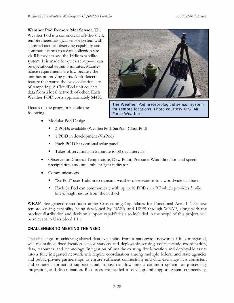
Wildland Fire Weather: Multi-agency Capabilities Portfolio 2. Functional Area 1
2-28
Weather Pod Remote Met Sensor. The Weather Pod is a commercial off-the-shelf, remote meteorological sensor system with a limited tactical observing capability and communications to a data collection site via RF modem and the Iridium satellite system. It is made for quick set-up—it can be operational within 5 minutes. Mainte-nance requirements are low because the unit has no moving parts. A tilt-detect feature that warns the base collection site of tampering. A CloudPod unit collects data from a local network of other. Each Weather POD costs approximately $44K. Details of the program include the following:
Modular Pod Design
3 PODs available (WeatherPod, SatPod, CloudPod)
1 POD in development (VisPod)
Each POD has optional solar panel
Takes observations in 5 minute to 30 day intervals
Observation Criteria: Temperature, Dew Point, Pressure, Wind direction and speed, precipitation amount, ambient light indicator
Communications
“SatPod” uses Iridium to transmit weather observations to a worldwide database
Each SatPod can communicate with up to 10 PODs via RF which provides 3 mile line-of-sight radius from the SatPod
WRAP. See general description under Crosscutting Capabilities for Functional Area 1. The new remote-sensing capability being developed by NASA and USFS through WRAP, along with the product distribution and decision support capabilities also included in the scope of this project, will be relevant to User Need 1.1.c.
CHALLENGES TO MEETING THE NEED
The challenges in achieving shared data availability from a nationwide network of fully integrated, well-maintained fixed-location sensor stations and deployable sensing assets include coordination, data, resources, and technology. Integration of just the existing fixed-location and deployable assets into a fully integrated network will require coordination among multiple federal and state agencies and public-private partnerships to ensure sufficient connectivity and data exchange in a consistent and coherent format to support rapid, robust dataflow into a common system for processing, integration, and dissemination. Resources are needed to develop and support system connectivity,
The Weather Pod meteorological sensor system for remote locations. Photo courtesy U.S. Air Force Weather.
Wildland Fire Weather: Multi-agency Capabilities Portfolio 2. Functional Area 1
2-29
regardless of where systems are located location or their status as permanent (fixed location) or variable (deployable) sources of observations. Resources are also needed to ensure dedicated maintenance and support of the contributing systems. Additionally, the appropriate technology must be leveraged to allow for automated observing and data collection, to reduce staffing requirements and to ensure rapid transmission and availability of all observed data. Efforts to meet this need completely will no doubt proceed incrementally and are likely to involve several of the current players (see discussion below of potential approaches). An overall strategy, agreed upon by key resource providers and users in the wildfire community, is essential to avoiding duplication of effort, stovepiped developments that cannot be easily integrated down the road, and unnecessary delays in getting to the desired goal state.
1.1.d The comprehensive, prioritized list of needed observed and predictive fire weather data elements developed from this assessment should be refined and validated.
DESCRIPTION OF THE NEED
The following list of data elements resulted from analysis by the JAG/NWFWNEA of the responses received to the needs assessment questionnaire. Although this list has the advantage of coming from the user community, it is nevertheless preliminary. It should be refined and validated, based on the role of the data in generating the products and services most important to wildland fire users. In presenting this preliminary list, the JAG/NWFWNEA stressed that some environmental parameters may not seem important to wildland fire users, yet they may be essential for accurate numerical modeling on which the products and services critical to operational wildland fire users are based. In this preliminary list, data elements are prioritized only at the group level (e.g., Highest Priority); within each group, the elements are listed in alphabetical order (not prioritized).
Highest Priority
20 foot wind direction. 20 foot wind direction data were rated as important for 93% of users and their accuracy and availability were rated fairly high.
20 foot hourly wind peak. 20 foot hourly wind peak data were rated as important for 81% of users and its accuracy and availability were rated fairly high.
20 foot wind speed. 20 foot wind speed data were rated as important for 97% of users and their accuracy and availability were rated fairly high. Users also requested greater spatial and temporal resolution in the data made available to them.
Fuel moisture data. Fuel moisture data was rated as important for 93% of users and its accuracy and availability were rated fairly high. Additionally, users desire it at greater spatial and temporal resolution.
Lightning data. Lightning data was rated as important for 86% of users. However, many users indicated they require much more lightning data than is currently available. In fact, only two other parameters were rated lower for data sufficiency. For a data element which rated as important to such a high number of users, improvements in lightning data availability are crucial.
Wildland Fire Weather: Multi-agency Capabilities Portfolio 2. Functional Area 1
2-30
Mixing height. Mixing height was rated as important for 83% of users and its accuracy and availability were rated fairly high.
Precipitation data (amount and duration). Precipitation data was rated as important for 98% of users and its accuracy and availability were rated fairly high. Users also noted a need for spatial resolution of these data.
Relative humidity. Relative humidity height was rated as important for 98% of users and its accuracy and availability were rated fairly high.
Surface air temperature. Surface air temperature was rated as important for 98% of users and its accuracy and availability were rated highly.
Moderate Priority
2.5 micron particulate matter/smoke concentration. While 46% of users considered this information as important, users believed this data element to be the one least available and/or accurate. It should also be noted that this data element has been of growing importance to the community due to recent changes in environmental policies concerning air pollution. Therefore, this is expected to be an area of increased interest.
Cloud cover percentage. Cloud cover percentage was considered important by 58% of users and its accuracy and availability were rated fairly high.
Fuel temperature. Fuel temperature was considered important by 58% of users and its accuracy and availability were rated fairly high.
Lapse rate. Lapse rate was only considered important to 44% of users. However, it is worth noting that lapse rate data rated as third from last in terms of data availability.
Upper air winds. Upper air winds were considered important by 68% of users and its accuracy and availability were rated fairly high.
Lesser Priority
Barometric pressure. Only 13% of users considered this data element to be important to their operations. Furthermore, it earned the lowest important rating by users. And, it earned the highest marks for data sufficiency and accuracy. However, it is important to note that this element is valuable in developing weather analyses of current conditions and in numerical weather modeling. Furthermore, it is an important element for its second-order benefits to users.
Soil moisture. Soil moisture was considered important by 31% of users. It also earned low marks in availability and accuracy. However, it is important to note that soil moisture is an important element within numerical modeling. Therefore, users would benefit from better soil moisture characterizations, despite their direct impression of the usefulness of this element.
Solar radiation. Solar radiation was considered important by 35% of users. Detailed user rating percentages for each of these data elements are included in the following table. However, as mentioned previously, it is very important to note that these responses were based
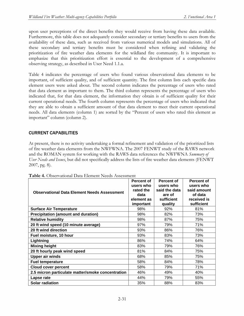
Wildland Fire Weather: Multi-agency Capabilities Portfolio 2. Functional Area 1
2-31
upon user perceptions of the direct benefits they would receive from having these data available. Furthermore, this table does not adequately consider secondary or tertiary benefits to users from the availability of these data, such as received from various numerical models and simulations. All of these secondary and tertiary benefits must be considered when refining and validating the prioritization of fire weather data elements for the wildland fire community. It is important to emphasize that this prioritization effort is essential to the development of a comprehensive observing strategy, as described in User Need 1.1.a. Table 4 indicates the percentage of users who found various observational data elements to be important, of sufficient quality, and of sufficient quantity. The first column lists each specific data element users were asked about. The second column indicates the percentage of users who rated that data element as important to them. The third column represents the percentage of users who indicated that, for that data element, the information they obtain is of sufficient quality for their current operational needs. The fourth column represents the percentage of users who indicated that they are able to obtain a sufficient amount of that data element to meet their current operational needs. All data elements (column 1) are sorted by the “Percent of users who rated this element as important” column (column 2).
CURRENT CAPABILITIES
At present, there is no activity undertaking a formal refinement and validation of the prioritized lists of fire weather data elements from the NWFWNA. The 2007 FENWT study of the RAWS network and the ROMAN system for working with the RAWS data references the NWFWNA Summary of User Needs and Issues, but did not specifically address the lists of fire weather data elements (FENWT 2007, pg. 8). Table 4. Observational Data Element Needs Assessment
Observational Data Element Needs Assessment
Percent of users who rated the
data element as important
Percent of users who
said the data are of
sufficient quality
Percent of users who
said amount of data
received is sufficient
Surface Air Temperature 98% 92% 81% Precipitation (amount and duration) 98% 82% 73% Relative humidity 98% 87% 75% 20 ft wind speed (10 minute average) 97% 79% 71% 20 ft wind direction 93% 86% 76% Fuel moisture, 10 hour 93% 83% 73% Lightning 86% 74% 64% Mixing height 83% 79% 76% 20 ft hourly peak wind speed 81% 84% 75% Upper air winds 68% 85% 75% Fuel temperature 58% 84% 78% Cloud cover percent 58% 79% 71% 2.5 micron particulate matter/smoke concentration 46% 49% 40% Lapse rate 44% 79% 55% Solar radiation 35% 88% 83%
Wildland Fire Weather: Multi-agency Capabilities Portfolio 2. Functional Area 1
2-32
Soil moisture 31% 75% 65% Barometric pressure 13% 94% 86%
CAPABILITIES IN DEVELOPMENT
NICC/GACC Predictive Services Units. See general description under Crosscutting Capabilities for Functional Area 1. The National Predictive Services Subcommittee and Predictive Services staff could contribute to refining and validating the fire weather data elements that will fulfill User Need 1.1.d. NWFEA. See general description of NWFEA under Capabilities in Development for Functional Area 1. Goal 2, An Integrated Data Environment, of the draft NWFEA Blueprint contains recommendations, together with action items to implement them, which can easily incorporate the refinement and validation of fire weather data elements that will fulfill User Need 1.1.d. A distinct advantage of undertaking this refinement and validation under the auspices of the NWFEA is that it will foster consideration of the interrelationships among fire weather data elements and the broader domain of Wildland Fire Enterprise data elements necessary to meet NWFEA Goal 2.
CHALLENGES TO MEETING THE NEED
The contributing factors which must be addressed to resolve this need include coordination and data. Refining and validating a prioritized list could be readily accomplished by dedicated coordination amongst the various agencies, provided that those conducting this prioritization fully understand all of the benefits of each type of data, both direct and indirect. Data are a contributing factor because all of the data must be collected and disseminated. The solution time for this user need is identified as short term. Provided this requirement receives the appropriate level of agency coordination and support, it could readily be met in the short term.
1.2 All national weather station standards (to include those used by other agencies and NFDRS standards) should be reevaluated to ensure proper integration of all pertinent weather station data (to include portable weather stations) for use by the wildland fire community.
DESCRIPTION OF THE NEED
The existence of weather station standards leads to many direct and indirect benefits. As indicated by one user, “data standards, data format and data delivery are major areas that require more development.” Notably, standard measurement collection processes allows for users to accurately compare measurements from other stations, both nearby and distant, and know that the difference are due to the environment, not sensor placement or type. This also facilitates the use of these observations in numerical simulations and in operational decision aids, for the same reason. These types of systems rely on awareness of how the measurements are taken and recorded, and greatly make use of that information. Standards also allow for easier maintenance and calibration of systems, which also impacts the training needed to provide maintenance and calibration. Standard system types, configurations, and data types, lead to tremendous efficiencies with respect to this.
Wildland Fire Weather: Multi-agency Capabilities Portfolio 2. Functional Area 1
2-33
Furthermore, weather station standards also serve the fire weather community through tertiary benefits. One example of this is the fact that industry can much more efficiently develop sensors to a set National standard, than they can for varied standards established by different agencies. National standards allows industry to build products and services to meet that standard, allowing for greater efficiencies in their operations, greater competition among themselves, and ultimate, better equipment at lower costs for the Nation. These benefits cannot be overstated. Any and all existing data standards, used by all agencies that collect environment data, must to be evaluated for their universal importance to the wildland fire community. Those standards of common importance should then be established as national standards for all meteorological measurement sites—at least for those sites in non-urban areas. Furthermore, additional weather station standards should be developed, as they have merit. Inclusion of data standards important to wildland fire weather into national standards for all sites would improve wildland fire support across the Nation.
CURRENT CAPABILITIES
ASOS Standards. Data standards for ASOS are contained in Federal Meteorological Handbook No. 1(FMH-1), Surface Weather Observations and Reports, available in HTML format at www.nws.noaa.gov/oso/oso1/oso12/fmh1.htm. A description of the three levels of quality control for operational ASOS sites can be found in section 1.4, “Quality Control,” of the Automated Surface Observing System (ASOS) User’s Guide, available in PDF format at www.nws.noaa.gov/asos/pdfs/aum-toc.pdf. DRI-CEFA. See general description under Crosscutting Capabilities for Functional Area 1. The WRCC at DRI provides input for NWCG fire weather station standards. NWCG Fire Weather Station Standards for RAWS. For general description of the RAWS network and NWCG/FENC activities for RAWS, see the Crosscutting Capabilities section for Functional Area 1.The May 2008 revision of the NWCG Fire Weather Stations Standards contains the latest data standards for fixed location RAWS (denoted as NFDRS Weather Stations) and for the NIFC’s deployable Fire RAWS units (NWCG 2008c). The Fire Weather Committee of FENC (formerly FENWT) works with the RAWS partners to update the Fire Weather Station Standards on an annual cycle (FWC 2008). Public and Private Sector Mesonets. Regional and local surface observing mesonets, such as the Oklahoma Mesonet and the 90-plus mesonets accessible through MesoWest each have their own station quality control and maintenance procedures. See general descriptions of MesoWest and of the Oklahoma Mesonet and OK-FIRE under the Crosscutting Capabilities section for Functional Area 1. The NOAA MADIS capability provides quality control information for the 57 mesonets, including RAWS, that it covers. See general description under Crosscutting Capabilities for Functional Area 1.
CAPABILITIES IN DEVELOPMENT
Nationwide Network of Observing Mesonets. See general description of the work of the OFCM CIOS in implementing a nationwide observing network, under Crosscutting Capabilities in
Wildland Fire Weather: Multi-agency Capabilities Portfolio 2. Functional Area 1
2-34
Development for Functional Area 1. Evaluation and standardization of the weather observing mesonets to be incorporated into a nationwide network is part of the Terms of Reference for the CIOS. NICC/GACC Predictive Services Units. See general description under Crosscutting Capabilities for Functional Area 1. The National Predictive Services Subcommittee and Predictive Services staff are involved in setting standards for NFDRS observing stations. Currently most of these stations are in the RAWS network, but other mesonets are being evaluated for suitability as official Fire Weather Stations, including as sources of weather input data to the daily NFDRS computations. Also see the description of the Interagency RAWS Network and WIMS under Crosscutting Capabilities for Functional Area 1 and general description for WFAS and NFDRS under Crosscutting Capabilities for Functional Area 3. NWFEA. See general description of the NWFEA program under Crosscutting Capabilities in Development for Functional Area 1. Goal 2, An Integrated Data Environment, of the draft NWFEA Blueprint contains recommendations that, together with the action items to implement them, will accomplish the evaluation of weather station standards called for in Need 1.2.
CHALLENGES TO MEETING THE NEED
The contributing factors which must be addressed to resolve this need include data, science, and technology. Agencies involved in observing environmental conditions should document the standards required for their observations, and should advocate that their standards become national standards to better ensure that all available data can be used to meet their needs. This effort requires leveraging scientific understanding to best measure and interpret sensed data, and to maximize the ability of current sensor technology to meet observational data requirements. Improved science is needed to support the establishment of meaningful standards regardless of sensor type and/or geographic region of interest. This solution time required to meet this need has both short and long-term components due to the fact that some items can be readily addressed while others will take considerable time.
Wildland Fire Weather: Multi-Agency Capabilities Portfolio 3. Functional Area 2
3-1
Chapter 3 Functional Area 2: Fire Weather Research
and Development
Fire Weather research and development (R&D) includes all basic and applied research and development (applications and technology) relating to wildland fire. Examples of important components of fire weather R&D include: fire meteorology, fire danger, fire behavior, and fuels condition. User input for this area will help to delineate and prioritize R&D requirements. However, R&D requirements and priorities will also depend on expert judgment about the best ways to address other functional areas where users have firsthand knowledge of what will help them—particularly the Products and Services needs (Functional Area 3). The following topics were covered by user input in this functional area:
Identification of current research programs, projects, and initiatives viewed by users as relevant to wildland fire weather, covering all the scientific disciplines that may be relevant to advances in products and services for the wildland fire community
Users’ assessments of knowledge gaps (and complementary areas of knowledge) in disciplines relevant to wildland fire weather
The spectrum of users’ needs and requirements for fire weather R&D
Existing and potential research capabilities pertaining to this functional area (among Federal, state, local, private, and academic research entities), including indications of redundant or overlapping R&D activities that do not appear coordinated
Potential partnerships among R&D entities, including partnerships across two or more sectors (Federal, state, local, academic, or private)
Transition from R&D to operations and implementation of new science in decision making
The JAG analysis of user input for Functional Area 2 produced four major needs. The first of these, divided into three subneeds, covers R&D topics of interest to the wildland fire weather community, particularly on topics where they perceive a lack of the underlying science and understanding needed to help them in their work. The other three issues (2.2 through 2.4) are more process-related; they address: how the user community gets research results, how R&D is transitioned into operations, and users’ interest in being more effectively integrated into the R&D effort early enough to provide effective feedback on operational usefulness.
Crosscutting Capabilities
The following capabilities are relevant to two or more user needs identified by the NWFWNA. The general description of crosscutting capabilities that first appear under Functional Area 2 is given once, in this section. The specific relevance of a crosscutting capability to an individual need is noted in the Current Capabilities or Capabilities in Development subsection under that need.
Wildland Fire Weather: Multi-Agency Capabilities Portfolio 3. Functional Area 2
3-2
Forest Service Rocky Mountain Research Station (RMRS). The fourteen research laboratories of the RMRS conduct research throughout a 14-state territory that encompasses the Great Basin, the Rocky Mountains, the Southwest, and parts of the Great Plains. In addition to projects that directly contribute to wildland fire management planning and decision-making, the work of the RMRS contributes to important related areas such as understanding the ecological impacts of wildland fire and the implications of climate change trends for wildfire patterns. The Fire, Fuel and Smoke Program of the RMRS is conducted at the Rocky Mountain Center for Advanced Modeling of Meteorology and Smoke (RMC), located in Fort Collins, Colorado, and at the Missoula Fire Sciences Laboratory in Montana. The six current focus areas of the program are Physical Fire Dynamics, Fuel Dynamics, Smoke Emissions and Dispersion, Fire Ecology, Fire and Fuel Management Strategies, and Science Synthesis and Delivery. The RMC's primary objective is the continuous development and deployment of science-based computer applications for real-time delivery of fire-weather intelligence and smoke forecasts to support wildland fire operations, prescribed burns, and air-resource management in the western United States. The RMC serves the fire- and smoke-management community with highly customized value-added weather products and a quick response to field-users’ requests for weather intelligence. Its website offers over 100,000 weather products and tools to assist fire and smoke managers. The RMC currently supports 4 western GACCs with critical weather information for the Rocky Mountain, Southwest, Eastern Great Basin, and Western Great Basin regions. Fire and smoke managers use RMC products to: (1) accurately assess fire danger, (2) plan prescribed burns, (3) allocate firefighting resources, and (4) measure the impacts of smoke from burns and wildfires. Increasingly, other users such as the outdoor recreation industry are using the RMC to plan activities and manage enterprises. The RMC also serves as a rich platform for exploring research questions related to the effects of climate variability and integrating climate research results with location-specific data and management problems. Joint Fire Science Program (JFSP). The JFSP was created by Congress in 1998 as an interagency research, development, and applications partnership between DOI and USDA. In response to congressional direction, the JFSP develops science-based knowledge and tools to support federal, tribal, state, and local agencies and their partners in the following areas:
Fuel inventory and mapping
Fuel treatment planning, scheduling, and risk assessment
Fire effects and fire behavior
Monitoring and evaluation
Restoration of fire-adapted ecosystems
Post-fire stabilization and rehabilitation
Remote sensing
Developing and integrating research information for local land managers An annual cycle of proposal solicitation, review, and funding ensures timely response to evolving conditions. Research projects complement and build on other federal research programs, such as those in the Forest Service Forest and Rangeland Research Stations, U.S. Geological Survey, and
Wildland Fire Weather: Multi-Agency Capabilities Portfolio 3. Functional Area 2
3-3
National Fire Plan. Synthesis of research findings and targeted delivery to managers are essential components of the Program. From 1998 through 2006, JFSP has funded 380 research proposals. A highly competitive, peer-review process consisting of land managers, technical specialists, and scientists ensures that the very best projects are accepted for funding. On average, about 20 percent of the submitted proposals are selected. In 2008–2009, the JFSP worked with the Fire Weather Subcommittee of the NWCG to develop a list of user-relevant research issues that could be addressed through targeted JFSP calls for research proposals. National Center for Atmospheric Research (NCAR). NCAR has been sponsoring wildland fire weather research and development for the past decade. The objectives of the work have been to (1) understand interactions between 4-dimensional weather and wildland fire that influence fire behavior and growth, (2) to develop, test, and evaluate a wildland fire model that provides accurate fire behavior simulations over landscape-scale fires, (3) to apply analysis of infrared imagery to understand the dynamical interactions between fire and the atmosphere, (4) to develop, test, and evaluate a faster-than-real-time forecast modeling system of weather, fire behavior, and their interactions with sufficient skill according to user-defined metrics, while building a forum for the testing and evaluation of a broad range of modeling tools and methods, and (5) to develop open source community models and forums for community collaboration for diverse, interdisciplinary, geographically-distributed participants to advance research, educations, and fire management technology. National Ventilation Index Value Maps in Association with Transport Winds and Mixing Heights for a 7-Day Forecast. CANSAC, the Air Fire Team within U.S. Forest Service Research, and National Climate Predictive Services at NIFIC, along with regional Air Quality and Smoke Managers with climate and meteorological backgrounds, are working to develop national products that support wildland fire and smoke management decisions. These experimental weather products include national mixing heights, transport wind speed and direction, and ventilation index values. The proposed experimental weather products would be included in a 7-day forecast updated every 3 hours. Also under discussion is inclusion of national maps for air stagnation and visibility reduction. NOAA Smoke Forecasting System. NOAA’s current operational Smoke Forecasting System (SFS) provides guidance to air quality forecasters and the public for fine particulate matter (≤ 2.5 mm) emitted from large wildfires and agricultural burning, which can elevate particulate concentrations to unhealthful levels. The SFS uses the National Environmental Satellite, Data, and Information Service’s (NESDIS) Hazard Mapping System (HMS), which is based on satellite imagery, to establish the locations and extents of the fires. The particulate matter emission rate is computed using the emission processing portion of the U.S. Forest Service’s BlueSky Framework, which includes a fuel-type database, as well as consumption and emissions models. The Hybrid Single Particle Lagrangian Integrated Trajectory (HYSPLIT) model is used to calculate the transport, dispersion, and deposition of the emitted particulate matter. Evaluation of the SFS is carried out by comparing predicted smoke levels with actual smoke detected from satellites by the HMS and the GOES Aerosol/Smoke Product. This overlap is expressed as the figure of merit in space (FMS), defined as the intersection over the union of the observed and calculated smoke plumes. Results are available for the 2007 fire season (September 2006–November 2007). While the highest FMS scores for individual events during the 2007 season
Wildland Fire Weather: Multi-Agency Capabilities Portfolio 3. Functional Area 2
3-4
approach 60%, average values for the 1 and 5 mg/m3 contours for the analysis period were 8.3% and 11.6%, respectively. FMS scores for the forecast period were lower by about 25% due, in part, to the inability to forecast new fires. The HMS plumes tend to be smaller than the corresponding predictions during the winter months, suggesting that excessive emissions predicted for the smaller fires resulted in an overprediction in the smoke area. In another SFS evaluation study, the model’s sensitivity to injection height was tested against satellite and surface measurements, taken as ground truth. Contours of particulate matter concentrations with a diameter less than or equal to 2.5-mm (PM2.5) concentration levels, simulated by the SFS, were evaluated Four multiday forest fire case studies, one covering the continental United States, two in California, and one near the Georgia–Florida border, have been analyzed. The column-integrated PM2.5 concentrations for these cases compared to the satellite measurements showed a similar or better statistical performance than the mean performance of the SFS for the period covering 1 September 2006–1 November 2007. However, near the surface, the model shows a tendency to overpredict the measured PM2.5 concentrations in the western United States and underpredict concentrations for the Georgia–Florida case. Furthermore, a sensitivity analysis of the model response to changes in the smoke release height shows that the simulated surface and column-integrated PM2.5 concentrations are very sensitive to variations in this parameter. Indeed, the model capability to represent the measured values is highly dependent on the accuracy of the determination of the actual injection height and in particular to whether the smoke injection actually occurred below or above the planetary boundary layer. NSF Research Grants. Wildland fire-related research has no specific organizational home within NSF. Instead it has been funded through interdisciplinary and disciplinary grants from several NSF directorates including the Directorate for Computer & Information Science & Engineering, the Directorate for Mathematics and Physical Sciences, and Geosciences (specifically, in the suborganization, Atmospheric Sciences). Technology transfer of fire weather has been funded by the NSF Small Business Innovative Research program (SBIR) through the Division of Industrial Innovation and Partnerships. NSF is the core funder for NCAR (see above in this section). Although NCAR is by far the largest conduit for NSF funding relevant to fire weather and wildland fire management, a number of individual principal investigator grants in several directorates, representing discipline-oriented research areas, are either directly or indirectly relevant. The following NSF-funded projects are relevant to two or more User Needs.
An NSF grant relevant to User Needs in both Functional Area 1 and Functional Area 2 is entitled “Data Dynamic Simulation for Disaster Management.” The research team is creating a system where multiple sensors placed around a wildfire will continuously send inputs, such as temperature, wind direction and speed, and the moisture in grass and sticks, to a high-end research computer for analysis. The computer that will use a wildfire model to generate maps and forecasted fire locations, which are forwarded to the frontline incident team in real time. The onsite fire managers can see minute-by-minute predictions of where fire growth will occur along the fireline. The project work has included case studies illuminating stated user concerns about understanding the flow in mountainous terrain near fires and interactions between fires and atmospheric motions. This project is funded by NSF’s Computer and Information Sciences Directorate.
Wildland Fire Weather: Multi-Agency Capabilities Portfolio 3. Functional Area 2
3-5
A grant from the NSF Directorate of Geosciences (GEO) supported three-dimensional (3D) modeling of combustion and pollution from wildland fires.
Another NSF/GEO grant supports development of an Open Wildland Fire Modeling E-community. This e-community is envisioned as a virtual organization to accelerate research, education, and fire management technology by enabling a collaboration environment and automating the connection between community software in numerical weather prediction, multiple fire behavior models, component-based software engineering, and 3D visualization.
Other GEO grants have supported synoptic studies of the meteorological conditions associated with extreme fire behavior, application of an aerosol model to simulate smoke source functions that relate optical properties, optical depth, and plume height to the fire intensity, fuel type, and meteorological circumstances, development of web-based tools to support ad-hoc international work groups such as wildfires. The Engineering Directorate’s Natural and Manmade Hazard Mitigation Program has supported studies of past WUI cases such as the Oakland Hills fire of 1991. NSF research portfolios whose scope includes wildland fire research and development support are the Combustion, Fire, and Plasma Systems Program; the Chemical, Bioengineering, Environmental, and Transport Systems Program; the Natural and Manmade Hazard Mitigation Program within the Engineering Directorate; Petascale Computing programs in CISE. Crosscutting NSF-wide interdisciplinary funding opportunities of potential relevance to Wildland Fire Management include the Collaborations in Mathematical Geosciences program. Social aspects may be funded through the Directorate for Social, Behavioral & Economic Sciences. Numerous NSF programs support education and training. NSF supports purchase of research instrumentation, development of analysis techniques, and development of the software systems controlling instrumentation that may be applied in scientific field work. NSF also sponsors field research programs. Past NSF grants have supported development of self-configuring in situ wireless sensor networks in the vicinity of a fire and application of a Doppler Radar on Wheels for use in situations such as wildland fires to reveal the air motions in the vicinity of fires and smoke. The Division of Behavioral and Cognitive Sciences has supported doctoral dissertation work on multiresolution approaches to remote sensing of fire fuels. The NSF SBIR program supported Fire Information from REmote-sensing and Weather-models Integrated and Supplied to End-users (FIREWISE) South Dakota School of Mines and Technology (SDSMT) Curriculum in Wildfire Management. In response to perceived needs both nationally and internationally in fire science and particularly in wildland fire management, the State of South Dakota and the South Dakota School of Mines & Technology are developing a first-of-its-kind undergraduate degree program in Wildland Fire Management. This program will be grounded in the physical sciences (especially atmospheric sciences) with some required coursework in forestry, biology, and ecology. Students will also receive practical training each summer that they are enrolled in the program and will also be able to complete required skills courses for career advancement. A graduate program in Wildland Fire Management is also proposed. The developers’ intent is that, by allowing students to begin studying fire management in an undergraduate forestry programs, graduates of the program will be prepared to make better informed decisions regarding the behavior, impact, and occurrence of both naturally
Wildland Fire Weather: Multi-Agency Capabilities Portfolio 3. Functional Area 2
3-6
occurring and prescribed fire in wildlands. Ultimately, the program hopes to contribute to improving the capability to predict fire behavior and to determine the optimal types and amounts of resources needed to manage wildfires. Wildland Fire Lessons Learned Center. The Lessons Learned Center is located at the National Advanced Fire and Resource Institute, Tucson, Arizona, and has been operating since May 2002. It is an interagency program chartered by the NWCG. Center staff are employees of or are funded by one of the wildland fire management agencies. The center provides the wildland fire community with a safe learning environment that can receive honest input on problems and issues while being a trusted distributor of information created and contributed by the community. The center’s activities include collecting and analyzing observations, retaining knowledge of lessons learned and effective practices from fire incidents, transferring knowledge and information, and incorporating lessons learned into the wildland fire training curriculum. The center currently maintains four websites: (1) Library of Lessons Learned (www.wildfirelessons.net) to which community members can submit documents and stories; (2) The Community Center (www.myfirecommunity.net); (3) The Team Center (www.IMTcenter.net), where an incident management team can set up its own communications webspace for that team; and (4) My Fire Videos (www.myfirevideos.net), where users can post videos to a searchable database. WRF-Chem Model. NOAA/ESRL/GSD has developed a NWP model that couples the Weather Research and Forecasting (WRF) modeling framework with atmospheric chemistry to simulate atmospheric chemistry and aerosols from cloud scales to regional scales. This WRF-Chem model was developed with funding and research contributions from NOAA, NCAR, Pacific Northwest National Laboratory, the U.S. Environmental Protection Agency (EPA), and university scientists. The multiscale air pollution prediction system used in WRF-Chem couples a WRF-based NWP model with the Regional Atmospheric Chemistry Model (RACM). In addition, biogenic and anthropogenic emissions, deposition, convective and turbulent chemical transport, photolysis, and advective chemical transport are all computed simultaneously with the meteorology in each forward processing step. WRF-Chem is being used for experimental air quality forecasts. When combined with a parameterized smoke plume release, this precursor to a fully coupled system can estimate the release and evolution of smoke. Combined with MODIS Direct Broadcast hotspot and burnspot data (from the Missoula Fire Sciences Laboratory of RMRS) and fuel data, a modeling system of WRF plus WRF-Chem can simulate smoke release and transport.
2.1 The fire community needs a better understanding of the physical processes associated with fire potential, fire combustion, wildland fire smoke, and climate change/climate variability.
Wildland fire weather users rely heavily on the scientific understanding of the physical processes of fires when managing wildland fire events and potential events. Because of this, it is vital that the latest scientific discoveries and principles are available for users. Furthermore, improvements the scientific knowledge of the physical processes of fire hold great promise in supplying the wildland fire community with improved products and decision aids to help them complete their mission.
Wildland Fire Weather: Multi-Agency Capabilities Portfolio 3. Functional Area 2
3-7
The dynamics between the atmosphere and fires requires further study and research, leading to better understanding of the drivers of fire behavior. Researchers must better understand fire danger and behavior based on physics, not just the algorithms devised by empirical investigations during the 1960’s. Existing fire danger indices, such as the Haines index, require greater research emphasis. New management methods must also be developed based on this improved understanding. Users indicated that many research topics are of high importance. Furthermore, users also indicated that, in many cases, they require much more information regarding ongoing R&D efforts. Among the research topics that users noted as very important were the following:
Atmospheric stability (new Haines index)
Drought modeling
Duff moisture (impact of precipitation and weather on fire behavior)
Fire and climate change
Fire behavior. Users also indicated the extreme importance of fire behavior research, placing it second only to fire weather research. While 97% of users indicated this as an important area, less than half (48%), consider present research in this area to be of sufficient quantity.
Fire climatology
Fire danger
Fire detection
Fire ecology
Fire ecosystem impacts
Fire weather. This research topic was listed as important by 100% of users, yet only 55% indicated that they currently receive enough information on it. Users have a strong requirement for better predictions of wind direction and speed so they can use that information when managing wildland fires and in their land management practices. They also indicated the importance of improved understanding of weather elements in complex terrain for fire spread applications. Overall, wildland fire weather users have a strong requirement for a much better understanding of fire weather research in order to prevent and manage wildland fires and to better make use of all available resources.
Fuel treatments impacts
Lightning climatology
Mountainous wind patterns
Protecting people. Research on protecting people was rated as import by 93% of users, placing it third in the list. Despite that, only 35% of users believe they have access to sufficient information on related research.
Protecting structures
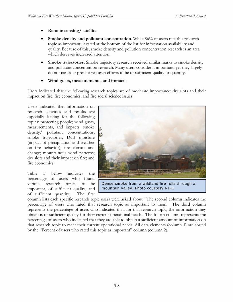
Wildland Fire Weather: Multi-Agency Capabilities Portfolio 3. Functional Area 2
3-8
Remote sensing/satellites
Smoke density and pollutant concentration. While 86% of users rate this research topic as important, it rated at the bottom of the list for information availability and quality. Because of this, smoke density and pollution concentration research is an area which deserves increased attention.
Smoke trajectories. Smoke trajectory research received similar marks to smoke density and pollutant concentration research. Many users consider it important, yet they largely do not consider present research efforts to be of sufficient quality or quantity.
Wind gusts, measurements, and impacts Users indicated that the following research topics are of moderate importance: dry slots and their impact on fire, fire economics, and fire social science issues. Users indicated that information on research activities and results are especially lacking for the following topics: protecting people; wind gusts, measurements, and impacts; smoke density/ pollutant concentrations; smoke trajectories; Duff moisture (impact of precipitation and weather on fire behavior); fire climate and change; mountainous wind patterns; dry slots and their impact on fire; and fire economics. Table 5 below indicates the percentage of users who found various research topics to be important, of sufficient quality, and of sufficient quantity. The first column lists each specific research topic users were asked about. The second column indicates the percentage of users who rated that research topic as important to them. The third column represents the percentage of users who indicated that, for that research topic, the information they obtain is of sufficient quality for their current operational needs. The fourth column represents the percentage of users who indicated that they are able to obtain a sufficient amount of information on that research topic to meet their current operational needs. All data elements (column 1) are sorted by the “Percent of users who rated this topic as important” column (column 2).
Dense smoke from a wildland fire rolls through a mountain valley. Photo courtesy NIFC
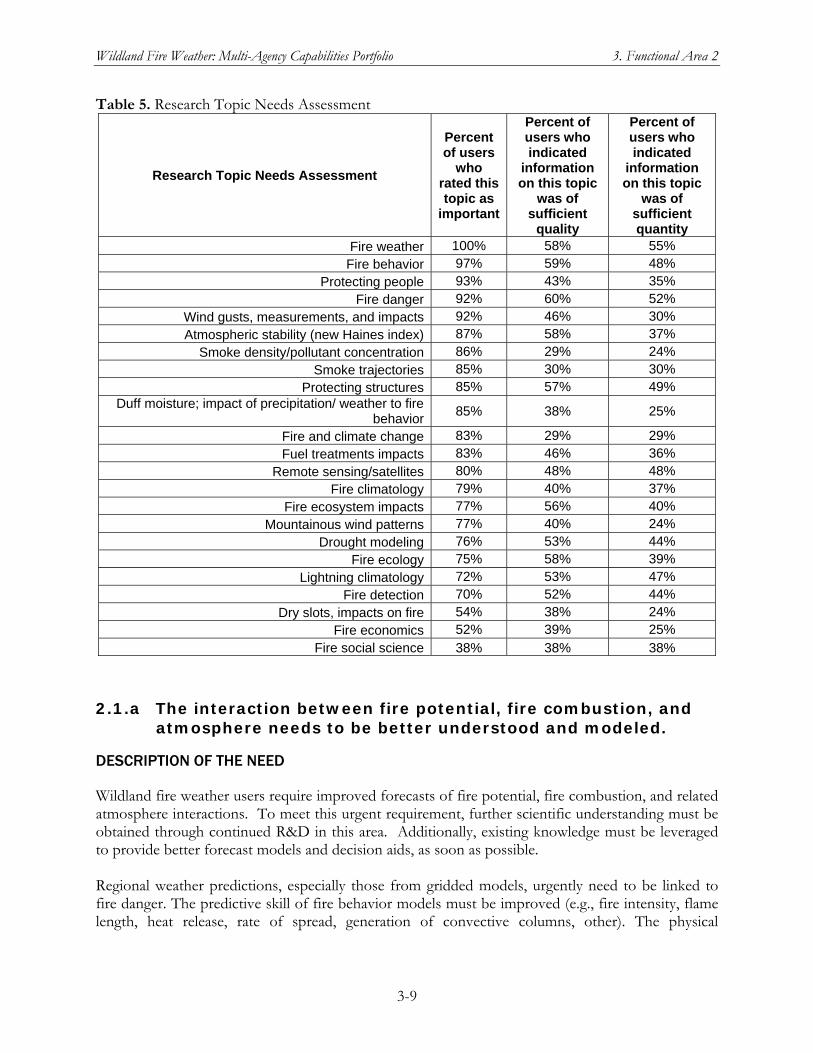
Wildland Fire Weather: Multi-Agency Capabilities Portfolio 3. Functional Area 2
3-9
Table 5. Research Topic Needs Assessment
Research Topic Needs Assessment
Percent of users
who rated this topic as
important
Percent of users who indicated
information on this topic
was of sufficient
quality
Percent of users who indicated
information on this topic
was of sufficient quantity
Fire weather 100% 58% 55% Fire behavior 97% 59% 48%
Protecting people 93% 43% 35% Fire danger 92% 60% 52%
Wind gusts, measurements, and impacts 92% 46% 30% Atmospheric stability (new Haines index) 87% 58% 37%
Smoke density/pollutant concentration 86% 29% 24% Smoke trajectories 85% 30% 30%
Protecting structures 85% 57% 49% Duff moisture; impact of precipitation/ weather to fire
behavior85% 38% 25%
Fire and climate change 83% 29% 29% Fuel treatments impacts 83% 46% 36%
Remote sensing/satellites 80% 48% 48% Fire climatology 79% 40% 37%
Fire ecosystem impacts 77% 56% 40% Mountainous wind patterns 77% 40% 24%
Drought modeling 76% 53% 44% Fire ecology 75% 58% 39%
Lightning climatology 72% 53% 47% Fire detection 70% 52% 44%
Dry slots, impacts on fire 54% 38% 24% Fire economics 52% 39% 25%
Fire social science 38% 38% 38%
2.1.a The interaction between fire potential, fire combustion, and atmosphere needs to be better understood and modeled.
DESCRIPTION OF THE NEED
Wildland fire weather users require improved forecasts of fire potential, fire combustion, and related atmosphere interactions. To meet this urgent requirement, further scientific understanding must be obtained through continued R&D in this area. Additionally, existing knowledge must be leveraged to provide better forecast models and decision aids, as soon as possible. Regional weather predictions, especially those from gridded models, urgently need to be linked to fire danger. The predictive skill of fire behavior models must be improved (e.g., fire intensity, flame length, heat release, rate of spread, generation of convective columns, other). The physical
Wildland Fire Weather: Multi-Agency Capabilities Portfolio 3. Functional Area 2
3-10
understanding of, and predictive skills for, the transitions from moderate- to high-intensity fires also must be improved.
CURRENT CAPABILITIES
Core Fire Science Caucus. This self-directed team of fire and atmospheric scientists is dedicated to improving the core physical science basis for fire management in order to give fire managers the ability to plan for and predict (in real time) the evolution of the combustion process, fuel involvement, heat transfer, and atmospheric interaction that occurs from the first point of ignition to the last moment of smoldering on the landscape. The caucus is developing an ego-less, turf-less community expression of the priority topics, for the next 5-20 years, for core fire science and for developing core fire behavior modeling. Current NWS Data Streams. See general description under Current Capabilities for Functional Area 1. The operational NWS data streams provide a larger-scale gridded dataset within which finer-scale observations and analyses can be nested. Such nested datasets can be used for research on the interaction of fire potential, atmospheric conditions, and fire behavior. FCAMMS. See general description of FCAMMS under Current Capabilities for Functional Area 1. Specifically with respect to User Need 2.1.a, an FCAMMS contact listed the following current activities:
Studies of fundamental atmospheric dynamics associated with fire convection on synoptic and mesoscales
Modeling focused on examining wildfire evolution in the convective boundary layer and convective plume dynamics, with an emphasis on atmospheric turbulence structures near fires
Field experiments focused on measurements of turbulence structures and fluxes of carbon dioxide and water during fires
Development of prototype mesoscale ensemble prediction system (MEPS) that will provide probabilities of occurrence for user-defined fire-weather conditions based on ensemble forecasting techniques
Identifying mesoscale boundaries that impact fire environments, identifying atmospheric precursors of fire-weather events in the Great Lakes region, and developing and implementing atmospheric based predictive indices for anticipating extreme fire behavior
Development of revised fuel model for the New Jersey Pine Barrens to improve MM5-based (1 km grid resolution) NFDRS predictions there
Development of monthly fire weather forecasts, an integrated fire weather/behavior prediction system and a weekly-to-seasonal dynamical/statistical hybrid fire potential forecasting system prototype that will yield probability maps of predicted number of fires and large fire occurrence for the western United States.
JFSP. See general description under Current Capabilities for Functional Area 2. User Need 2.1.a has been a major focus of JFSP research. The first three research areas in the statutory mandate for the program—fuel inventory and mapping; fuel treatment planning, scheduling, and risk assessment;
Wildland Fire Weather: Multi-Agency Capabilities Portfolio 3. Functional Area 2
3-11
and fire effects and fire behavior—are particularly relevant to the interactions among fuel potential, fire combustion, and the atmosphere. NASA MASTER. See general description of the NASA MODIS instrument and the MASTER airborne sensor system under Crosscutting Capabilities for Functional Area 1. MASTER represents an emerging capability for advanced remote sensing targeted to high-priority wildland fire incidents and emergencies. With respect to User Need 2.1.a, MASTER represents a research capability for collecting high-resolution data on atmospheric conditions, fuel and soil moisture, and fire behavior. NCAR. See general description under Current Capabilities for Functional Area 2. A continuing R&D effort at NCAR of particular relevance to User Need 2.1.a is development and open source release of a coupled atmosphere-fire module (WRF-Fire) for WRF (Weather Research and Forecasting), a community-developed environment for constructing advanced numerical weather prediction (NWP) models and associated subsystems such as data assimilation subsystems. National Science Foundation (NSF) Research Grants. See general descriptions of NSF research grants under Crosscutting Capabilities for Functional Area 2. The following NSF-funded projects were identified as specifically relevant to User Need 2.1.a:
Data Dynamic Simulation for Disaster Management (described in the NSF Research Grants entry for Crosscutting Capabilities, Functional Area 1)
Project on 3D modeling of combustion and pollution from wildland fires (described in the NSF Research Grants entry for Crosscutting Capabilities, Functional Area 2)
Development of an Open Wildland Fire Modeling E-community (described in the NSF Research Grants entry for Crosscutting Capabilities, Functional Area 2)
NICC/GACC Predictive Services Units. See general description under Crosscutting Capabilities for Functional Area 1. The National Predictive Services Subcommittee and staff in the Predictive Services units work with the fire weather R&D community to define questions relevant improving the understanding and modeling of interactions between fire potential, combustion, and atmospheric needs. More generally, Predictive Services serves in this role of a key operational user group for all of User Need 2.1. As an example, the JFSP recently worked with the Fire Weather Subcommittee on user needs that could be addressed through JFSP calls for research proposals. Predictive Services staff also serve as Federal agency liaisons for relevant JFSP-funded projects and interact with the principal investigators on those projects. Remote Sensing by Piloted Aircraft and UAS. See general description under Crosscutting Capabilities in Development for Functional Area 1. The NASA Ikhana UAS and the NASA-USFS Altair Fire Mission (see general description) have relevance to User Need 2.1.a With respect to User Need 2.1.a, NASA Ames Research Center and the USFS are already conducting high-resolution remote sensing of both land and some atmospheric parameters relevant to incident fire weather support, using airborne overflights by piloted aircraft and/or a UAS. Although this work is formally done on a research basis, it provides informal support to wildland fire-fighting operations.
Wildland Fire Weather: Multi-Agency Capabilities Portfolio 3. Functional Area 2
3-12
Satellite-based Observing System. See general description under Current Capabilities for Functional Area 1. With respect to User Need 2.1.a, several remote sensing products have been developed in recent years that provide an assessment of the current state of ground and above-ground fuels, such as Leaf Area Index, Fire Potential (related to the Normalized Difference Vegetation Index – NDVI), fuel loading estimates, atmospheric humidity profiles, etc. Satellite based algorithms such as the WildFire Automated Biomass Burning Algorithm (WFABBA), can detect fires with output parameters used for estimates of burned area. All of this information could be utilized in developing correlation models to better understand the relationship between antecedent/current conditions and fire actualization. USFS Riverside Fire Lab (Riggan). The Riverside Fire Lab is engaged in R&D on remote sensing of fire and the environment with aircraft-mounted sensors WRAP. See general description under Crosscutting Capabilities in Development for Functional Area 1. The WRAP objectives for developing new remote-sensing capabilities relevant to fire behavior and fire management, as well as the applications to use these new data streams, are relevant to the R&D needed to meet User Need 2.1.a
CAPABILITIES IN DEVELOPMENT
Integrated Earth Observation System (IEOS) planned capability. See general description under Crosscutting Capabilities in Development for Functional Area 1. SDSMT Curriculum in Wildfire Management. See general description under Crosscutting Capabilities for Functional Area 2.
CHALLENGES TO MEETING THE NEED
The challenges in meeting Need 2.1.a include data, resources, and science. Accurate incident-scale nowcasting and forecasting of surface conditions, particularly in broken terrain, is a technically demanding and specialized research area for which dedicated resources are needed. A substantial effort is required to acquire environmental data sets on actual fire behavior, at sufficient spatial and temporal density, to enable the research and validation efforts that will lead to better models. These environmental data must to be of sufficient quality and density not only to support initial research but also to evaluate the accuracy and effectiveness of new theories, techniques, and models before they are ready for transition to operational use by the wildland fire community. The path to meet these challenges has both short- and long-term components. Although substantial time and effort will be needed to develop a fully adequate understanding of fire-land-atmosphere interactions, some areas are ripe for rapid development into operationally useful improvements. These near-term opportunities for improving models and other prediction techniques can provide significant interim benefits for the wildland fire community while work continues on longer-term improvements.
2.1.b A better understanding of wildland fire smoke is needed, and smoke prediction tools need to be refined and perfected.
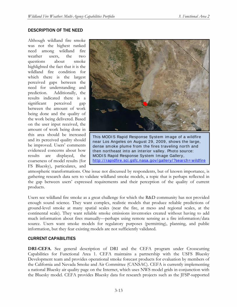
Wildland Fire Weather: Multi-Agency Capabilities Portfolio 3. Functional Area 2
3-13
DESCRIPTION OF THE NEED
Although wildland fire smoke was not the highest ranked need among wildland fire weather users, the two questions about smoke highlighted the fact that it is the wildland fire condition for which there is the largest perceived gaps between the need for understanding and prediction. Additionally, the results indicated there is a significant perceived gap between the amount of work being done and the quality of the work being delivered. Based on the user input received, the amount of work being done in this area should be increased and its perceived quality should be improved. Users’ comments evidenced concerns about how results are displayed, the coarseness of model results (for FS Bluesky), particulates, and atmospheric transformations. One issue not discussed by respondents, but of known importance, is gathering research data sets to validate wildland smoke models, a topic that is perhaps reflected in the gap between users’ expressed requirements and their perception of the quality of current products. Users see wildland fire smoke as a great challenge for which the R&D community has not provided enough sound science. They want complex, realistic models that produce reliable predictions of ground-level smoke at many spatial scales (near the fire, at meso and regional scales, at the continental scale). They want reliable smoke emissions inventories created without having to add much information about fires manually—perhaps using remote sensing as a fire information/data source. Users want smoke models for regulatory purposes (permitting), planning, and public information, but they fear existing models are not sufficiently validated.
CURRENT CAPABILITIES
DRI-CEFA. See general description of DRI and the CEFA program under Crosscutting Capabilities for Functional Area 1. CEFA maintains a partnership with the USFS Bluesky Development team and provides operational smoke forecast products for evaluation by members of the California and Nevada Smoke and Air Committee (CANSAC). CEFA is currently implementing a national Bluesky air quality page on the Internet, which uses NWS model grids in conjunction with the Bluesky model. CEFA provides Bluesky data for research projects such as the JFSP-supported
This MODIS Rapid Response System image of a wildfire near Los Angeles on August 29, 2009, shows the large, dense smoke plume from the fires traveling north and then northeast into an interior valley. Photo source: MODIS Rapid Response System Image Gallery, http://rapidfire.sci.gsfc.nasa.gov/gallery/?search=wildfire
Wildland Fire Weather: Multi-Agency Capabilities Portfolio 3. Functional Area 2
3-14
project on “Tools for Estimating Contributions of Wildland and Prescribed Fires to Air Quality in the Southern Sierra Nevada, California.” FCAMMS. See general description of FCAMMS under Crosscutting Capabilities for Functional Area 1. Relevant to User Need 2.1.b, FCAMMS is providing a platform to help evaluate uncertainty in each stage of the BlueSky model and to study plume representation for smoke transport from wildland fires. This platform also allows examination and testing of different air quality prediction systems for tactical and strategic prescribed burn planning. It is being used to carry out custom analyses of potential impacts of prescribed burns on local and regional air quality, which helps forest managers in developing strategic prescribed burn plans for fuels management. By coupling this BlueSky smoke modeling framework with EPA’s Community Multiscale Air Quality (CMAQ) model, FCAMMS is studying the effects of prescribed and wildland fires on regional air quality, including ozone pollution Another FCAMMS activity relevant to User Need 2.1.b is coupling the HYPACT model (name derived from Hybrid Particle and Concentration Transport) with the MM5 mesoscale NWP model to investigate local-scale dispersion of smoke from prescribed and wildland fires and to give land managers an additional tool for making burn/no burn decisions based on the predicted potential impact of smoke on the local environment and nearby communities. Related to this work on smoke modeling, FCAMMS research is addressing the formation and maintenance of superfog, which can reduce visibility over roadways to less than 3 meters. JFSP. See general description of the JFSP under Crosscutting Capabilities for Functional Area 2. Recent JFSP grants of specific relevance to User Need 2.1.b include multiple model validation projects funded in fiscal year 2008. An overarching activity is the Smoke and Emissions Modeling Intercomparison Project (SEMIP), which could provide a framework for comparing and integrating results from a number of research activities related to this User Need. NCAR Atmospheric Chemistry Division. See general description of NCAR under Crosscutting Capabilities for Functional Area 2. Of specific relevance to User Need 2.1.b, the Atmospheric Chemistry Division performs R&D on smoke constituents analysis, contributions of atmospheric constituents including smoke to fire behavior, and emissions models for analysis of regional transport. NCAR Mesoscale and Microscale Meteorology. See general description of NCAR under Crosscutting Capabilities for Functional Area 2. Some errors is smoke modeling arises from the disconnects among atmospheric modeling; emissions rates; and chemical evolution, dispersion, and transport. Community models in development and release include the WRF-Fire module, which is being developed by NCAR and numerous university collaborators and which is currently being released with the WRF community weather model. The WRF-File module can model multiple smoke-related processes simultaneously in a fully coupled and interacting manner. Such models couple fire behavior models with numerical weather prediction/atmospheric transport models to model fire intensity, time-varying latent and sensible heat fluxes, smoke fluxes, the fire plume produced, and the resulting plume intensity, height, penetration of the boundary layer or not, and the transport height. This couple approach to smoke modeling eliminates the need to estimate the smoke flux produced, how it is distributed with height, and how the flux changes with time. NICC/GACC Predictive Services Units. See general description of Predictive Services under Crosscutting Capabilities for Functional Area 1. Predictive Services uses the current models for
Wildland Fire Weather: Multi-Agency Capabilities Portfolio 3. Functional Area 2
3-15
smoke prediction and works with the R&D community on model improvements and new modeling capabilities. NOAA Smoke Forecasting System: See general description under Crosscutting Capabilities for Functional Area 2. RMRS Fire, Fuel and Smoke Program. See general description of the Forest Service RMRS under Crosscutting Capabilities for Functional Area 2. USFS Missoula Technology Development Center. See general description under Crosscutting Capabilities in Development for Functional Area 1 Within the Fire Laboratory at the Missoula Technology Development Center, Dr. Wei Min Hao is doing research on fire chemistry relevant to understanding and predicting wildland fire smoke. Wildfire Research and Application Partnership (WRAP). See general description under Crosscutting Capabilities in Development for Functional Area 1. WRF-Chem Model. See general description under Crosscutting Capabilities for Functional Area 2.
CAPABILITIES IN DEVELOPMENT
Satellite-based Observing Systems. See general description under Crosscutting Capabilities for Functional Area 1. Some smoke emission models use a parameter called ‘fire radiative power’ (FRP), which can be derived from remote-sensing observations of a wildland fire. Integrating the FRP over time provides an estimate of the fire radiant energy, which is proportional to the mass of fire fuel (biomass) combusted. However, there are limitations to the capability of current operational satellites to provide accurate FRP estimates and, therefore, accurate estimates of energy and fuel consumption for all fires. Some of these limitations are instrument-based (the resolution of the sensor, the radiative temperature at which the sensor saturates, etc); others are atmospheric/terrestrial constraints (atmospheric moisture and cloud cover, tree canopy effects, etc). Compounding these problems are the differences among space-based platforms that can provide this information (GOES, NOAA-AVHRR, MODIS). The ability to generate a fused product to seamlessly provide continually updated values of FRP for the lifetime of a fire will allow for more realistic smoke emissions from models that use this input. The transition to NPOESS and GOES-R in the future will help facilitate these goals by including sensors that will minimize the limitations indicated above. IEOS planned capability. See general description under Crosscutting Capabilities in Development for Functional Area 1 and the discussion above of potential improvements to remote-sensed observational data for estimating FRP. National Ventilation Index Value Maps in Association with Transport Winds and Mixing Heights for a 7-Day Forecast. See general description under Crosscutting Capabilities for Functional Area 2.
Wildland Fire Weather: Multi-Agency Capabilities Portfolio 3. Functional Area 2
3-16
CHALLENGES TO MEETING THE NEED
The contributing factors which must be addressed to resolve this need include data, resources, and science. As with need 2.1.a, this is also a challenging research area which requires dedicated resources in order to meet the need of the fire community. A substantial effort is required to acquire and collect the requisite environmental data to allow for better study and understanding of fire behavior which will lead to better modeling. These environmental data must also be of sufficient quality and density to not only provide for initial research, but to also evaluate the accuracy and effectiveness of new theories and models for eventual use by the operational community. This is a long-term need which will require a considerable amount of time to resolve. While the scientific understanding of smoke dispersion is becoming more and more understood, applying this to fine scale environments, which is critical to the operational usefulness of smoke products and services, will take time to develop.
2.1.c Wildland fire and climate change/climate variability is an issue of high concern, for which more scientific understanding is a priority.
DESCRIPTION OF THE NEED
Another area with a large gap between users’ expressed need and research is in the relation of climate and climate variability to wildland fire. Climate change effects on fire season length and severity is an issue that users recognize as needing more objective science. Users also wish to know how variability in fire weather patterns may be altered under a changing climate. Naturally, this area is closely linked with drought modeling and fire climatology themes, and it may be appropriate to address them together, under a common heading such as “Climate Variability and Fire.” However these topics and issues are categorized, there is an identified requirement to address variations in climate and their influence on fire from a landscape perspective. There also exists a significant gap between this requirement and users’ perceptions of the quantity and quality of the research being done. Some of the perceptions about quality may come from incomplete or non-existent information transfer from product developers to all levels of the fire management community. Reliable research information on climate change and fire must be transmitted to users in a manner that can be applied to the job. Representative user comments in this area include: “no hand-wringing,” “something useful”. Remote-sensing for climate variability influences to fire conditions, especially for fuels state, was also viewed as a research requirement. Additionally, at this time, carbon sequestration is recognized as an issue for fire management, but it is not seen as a priority research requirement in wildland fire management.
CURRENT CAPABILITIES
DRI-CEFA. See general description of DRI-CEFA under Crosscutting Capabilities for Functional Area 1. With respect to User Need 2.1.c, CEFA has ready access to all of the global climate model runs produced for and used by the Intergovernmental Panel on Climate Change (IPCC) and has been using the output from various models to analyze potential consequences of severe climate change on wildland fire. Two primary projects include the USFS Aldo Leopold Research Institute’s
Wildland Fire Weather: Multi-Agency Capabilities Portfolio 3. Functional Area 2
3-17
“Determining Regional Characteristics of WFU Thresholds Based on Climate and Fire Danger” and the JFSP-funded project “Assessing Fuels Treatments in Southern California National Forests in the Context of Climate Change.” JFSP. See general description of the JFSP under Crosscutting Capabilities for Functional Area 2.To date the JFSP had been addressing climate change as a factor of interest in many of its task statements [in JFSP proposal solicitations]. NICC/GACC Predictive Services Units. See general description under Crosscutting Capabilities for Functional Area 1. Predictive Services has a strong focus on monthly and seasonal outlooks for fire potential and maintains strong links into the relevant climate research community, including climate-related research sponsored by the JFSP and ongoing climate studies by the Forest Service and others. Measurements and Standards for the Climate Change Science Program (CCSP; now the U.S. Global Change Research Program). The National Institute of Standards and Technology (NIST) has responsibility for developing and maintaining measurement standards and fundamental measurement methods for critical observations relevant to understanding and predicting climate change. Determining how fast the global climate is changing and understanding the complex relationship among all the environmental variables to allow accurate predictions was one objective of the U.S. CCSP. For example, some of the drivers of climate, such as the sun’s output, may vary slowly over decades. As a result, climate predictions depend critically on developing absolute measurements of the sun’s energy that can be compared accurately over decades from different sensors. Other important variables include the sizes, shapes, and chemical composition of particles or droplets suspended in the atmosphere (aerosols). Whether aerosols contribute to warming or cooling Earth depends upon their composition and other properties. Many different climate monitoring systems on space-based platforms, on board airborne platforms, and on the ground are currently monitoring solar output and the trapping and reflection of heat by Earth’s atmosphere. These systems are operated by multiple countries and research groups. The reliability of the resulting information is influenced by the various measurement techniques and databases used. Establishment of absolute calibration and standard references will enable accurate comparisons of these systems, will help identify small environmental changes occurring over many years, and will reduce uncertainties in the data input to global climate change models. With the funding provided through this initiative and in coordination with other agencies, NIST is developing the following measurement standards and methods:
An international irradiance measurement scale to be used in rigorously calibrating satellite light intensity instruments prior to launch, to ensure sufficient accuracy to allow valid comparisons among results from different instruments or from data sets taken over different periods of time
Design strategies and quality assurance programs for new instruments, to optimize accuracy and stability of satellite- and ground-based solar measurement systems
Wildland Fire Weather: Multi-Agency Capabilities Portfolio 3. Functional Area 2
3-18
Techniques for generating specific types of aerosols in the laboratory, measuring aerosol optical and physical properties, and simulating aerosol properties that cannot yet be measured in the laboratory
A database of critically evaluated data on aerosol properties collected at NIST and elsewhere
USDA Office of Natural Resources and Sustainable Agricultural Systems (National Programs – Global Change). The objective of the Global Change Program in this USDA office is to develop and provide adaptation, mitigation, and management strategies suitable for the individual farm, ranch, or rural community. These strategies can be used by natural resource decisionmakers to help them derive optimal benefit from the positive aspects of global change and deal effectively with the detrimental effects. FCAMMS. See general description of FCAMMS under Crosscutting Capabilities for Functional Area 1. In a submission to OFCM, the FCAMMS identified the following activities as relevant to User Need 2.1.c:
Identifying what aspects of the atmosphere best describe the “fire environment” on short (diurnal) to long (multidecadal) time scales
Examining future atmospheric fire risk resulting from climate change
Characterizing future fire regimes and fire hazard potential under a changing climate
Using general circulation models of global climate and a regional climate model to examine the sensitivity of current Haines Index patterns for a changing climate
Investigation of the impact of climate variability on wildland fire occurrence and annual acres burned in Hawaii (completed activity; in partnership with the University of Hawaii)
Investigation of ENSO and the Southern Oscillation Index as a potential climate indicator of future fire activity in a seasonal time frame (completed activity)
CAPABILITIES IN DEVELOPMENT
SDSMT Curriculum in Wildfire Management. See general description under Crosscutting Capabilities for Functional Area 2.
CHALLENGES TO MEETING THE NEED
The contributing factors which must be addressed to resolve this need include data, resources, and science. As with needs 2.1.a and 2.a.b, this is also a challenging research area which requires dedicated resources in order to meet the requirements of the fire community. A substantial effort is required to acquire and collect the requisite environmental data to allow for better study and understanding of fire behavior which will lead to better modeling. These environmental data must be of sufficient quality and density to not only provide for initial research, but to also evaluate the accuracy and effectiveness of new theories and models for eventual use by the operational community. Although it will take a significant amount of time to fully develop a complete understanding of these fire interactions, some areas are already ripe for rapid development into
Wildland Fire Weather: Multi-Agency Capabilities Portfolio 3. Functional Area 2
3-19
operational use. Thus, this need could partially be met in the short term, which would significantly improve support to the wildland fire community.
2.2 Users need easier and more centralized access to information on research initiatives, efforts, and successes.
DESCRIPTION OF THE NEED
Users repeatedly stated that they need better access to research information. This was summed up nicely by one user who stated, “Fire weather research information should be readily available to fire weather and fire behavior specialists/meteorologists.” Furthermore, the current mechanisms for disseminating research information are not reaching the entire community. One user clearly stated, “Weather research information is largely inaccessible as most of those journals are not in the subscription lists of the agencies and are not available via public domain.” This inaccessibility must be resolved by making this information available through centralized access points, and through leveraging of recent technological advancements, rather than just the standard dissemination through formal research journals. Users seek nontraditional methods of delivering science results to get research and scientific information. While traditional science delivery methods such as journal articles are useful, other methods must be developed to supplement these traditional methods. For example, users want research information shared via the World-Wide Web (Internet). Users require an ability to subscribe to information so research of relevance to them is automatically sent to them. Additionally, personal meetings between users and researchers were considered to be an extremely beneficial way of delivering science information.
CURRENT CAPABILITIES
JFSP. See general description of the JFSP under Crosscutting Capabilities for Functional Area 2. Information on the JFSP website relevant to User Need 2.2 includes descriptions of JFSP proposal solicitations, awards made, results from completed projects (summaries and references to reports or journal articles), and abstracts of projects in progress. Program-Specific Research Information. The Federal agencies with wildland fire management research programs have information about their research on agency websites. However, this information typically is not centralized on the website or in a format that would give wildland fire community users easy access by topic to recent and ongoing research. Most of the current capabilities and capabilities in development listed for any of the functional areas have a website with information, which is likely to show up somewhere in the search results using the general-purpose web search engines. However, this type of access does not appear to meet the needs of users as summarized in User Need 2.2.
CAPABILITIES IN DEVELOPMENT
IEOS planned capability. See general description under Crosscutting Capabilities in Development for Functional Area 1. With respect to User Need 2.2, the Bush Fire Cooperative Research Center in Australia is interested in establishing a centralized source of information on wildland fire research in that country, and there has been discussion about expanding that to include research being done in the United States, Canada, and other countries.
Wildland Fire Weather: Multi-Agency Capabilities Portfolio 3. Functional Area 2
3-20
NICC/GACC Predictive Services Units. See general description under Crosscutting Capabilities for Functional Area 1. Predictive Services is both a user of information on current fire weather research and a communicator of that information to the broader wildland fire community. The Fire Weather Subcommittee and National Predictive Services Subcommittee of the NWCG Fire Environment Committee maintain working relationships with ESRL/GSD and other R&D entities in NOAA.
CHALLENGES TO MEETING THE NEED
The only contributing factor for this need is coordination. Coordination is required across agencies and programs to provide some kind of user-friendly summary of recent and ongoing research relevant to fire weather—and probably the entire RD domain for fire management. An important aspect of a cross-program, multi-agency access capability must be a mechanism to ensure that ensure information is current and reasonably complete. The solution time for this need is identified as short because with appropriate coordination, this need could be met in the near term.
2.3 Mature research needs to be integrated systematically into an operational environment for routine use by the fire community.
DESCRIPTION OF THE NEED
Wildland fire research agencies and operational agencies must collaborate and cooperate together to develop a process to systematically transition research efforts into operations. This effort also must allow for operational needs to feed into the research community so that future research efforts can be based upon user requirements. This area was also identified by the WGA as one in which greater communication and problem-solving between science and fire weather operations is required to provide for improved decision support to protect the public and vital natural resources.
CURRENT CAPABILITIES
FCAMMS. See general discussion of the FCAMMS under Crosscutting Capabilities for Functional Area 1. The FCAMMS consortia and centers study the atmospheric component of the fire environment across space and time scales, and its interaction with other components, using a balance of basic and applied science to provide tools to the field now, and to create a basis for future science applications. They bring scientists and land managers together to create a focused research program and promote science delivery. The regional structure of the FCAMMS allows better coordination with land management needs and locally important fire problems, but the science developed by the FCAMMS is globally relevant and shared among the regions as needed and appropriate. The FCAMMS works with the Region 6 Predictive Services unit, EPA, and NWS to move research products into operational use as developed and tested. It has also helped support
Wildland Fire Weather: Multi-Agency Capabilities Portfolio 3. Functional Area 2
3-21
transition of some research products in long-range dynamical fire weather forecasting and in short-range high resolution forecasting for fire behavior simulations. DRI-CEFA. See general discussion of DRI-CEFA under Crosscutting Capabilities for Functional Area 1. One of the CEFA mission areas is developing decision-support tools for the fire community and helping to translate science for decision-makers. Current operational products at CEFA include the 7-day RAWS-MOS forecast for GACC Predictive Services units, 15-day standardized Energy Release Component (ERC) for National Predictive Services at the NICC, 72-hour forecasts of fire weather and smoke concentration and transport for CANSAC, hourly fire danger for California FIRESCOPE, and the National Bluesky products of smoke concentration and transport, mixing height, ventilation index, and raw model output for GACC Predictive Services units. JFSP. See general discussion of the JFSP under Crosscutting Capabilities for Functional Area 2. With respect to User Need 2.3, the JFSP supports a series of research-to-operations syntheses oriented toward fire and fuels managers. NCAR Research Applications Laboratory. See general discussion of NCAR under Crosscutting Capabilities for Functional Area 2. Delivery of real time weather forecasts focused on wildfires. NEXRAD Weather Radar Network. See general discussion of NEXRAD under Crosscutting Capabilities for Functional Area 1. NICC/GACC Predictive Services Units. See general description under Crosscutting Capabilities for Functional Area 1. The National Predictive Services Subcommittee and staff in the Predictive Services units work with the fire weather R&D community to define research issues of importance to the community. More generally, Predictive Services is both a key operational user group for research results and new products and a key integrator of mature research into operations of the wildland fire community. For example, Predictive Services staff serve as Federal agency liaisons for relevant JFSP-funded projects and interact with the principal investigators on those projects. Wildland Fire Lessons Learned Center. See general discussion under Crosscutting Capabilities for Functional Area 2. Because of its close working relationship with the wildland fire community, this center represents a resource for ensuring that significant, evidence-based research gets translated into operational use. WRAP. See general discussion of WRAP under Crosscutting Capabilities in Development for Functional Area 1. A key objective of WRAP is for NASA to work closely with USFS toward successful implementation of a tactical wildfire disaster assessment and management system. Carrying out this objective to the end point of an operational system would represent a major accomplishment toward achieving User Need 2.3. Forest Service Missoula Technology Development Center. See general discussion under Crosscutting Capabilities in Development for Functional Area 1. NOAA/ESRL/GSD Fire weather products. Through products such as MADIS (see general description under Crosscutting Capabilities for Functional Area 1) and WRF-Chem (see general description under Crosscutting Capabilities for Functional Area 2.), ESRL/GSD has established a
Wildland Fire Weather: Multi-Agency Capabilities Portfolio 3. Functional Area 2
3-22
track record for working with user communities to produce systems and products tailored to user needs and accessible for operational use. NSF Research Grant: Open Wildland Fire Modeling E-community. See general description under Crosscutting Capabilities for Functional Area 2. An open-access e-community is an emerging approach to bringing potential users and model researchers/developers together on a continuing basis as modeling applications are being designed and developed.
CAPABILITIES IN DEVELOPMENT
IEOS planned capability. See general discussion under Crosscutting Capabilities in Development for Functional Area 1. MPAR Network. See general discussion under Crosscutting Capabilities in Development for Functional Area 1. Satellite-based Observing Systems. See general description under Crosscutting Capabilities for Functional Area 1. The NESDIS Satellite Analysis Branch (SAB) generates a daily, operational fire/smoke product for the Hazard Mapping System HMS. Direct links between NESDIS/SAB and the satellite research community have enabled effective transition of previous products and enhancements from the research to NESDIS operations. SDSMT Curriculum in Wildfire Management. See general description under Crosscutting Capabilities for Functional Area 2. Remote Sensing by Piloted Aircraft and UAS. See general description under Crosscutting Capabilities in Development for Functional Area 1.Both the NASA Ikhana UAS and the NASA-USFS Altair Fire Mission represent research projects that are providing results informally to operational wildland fire teams.
CHALLENGES TO MEETING THE NEED
The primary contributing factor which must be addressed to resolve this need is coordination. While some processes must be developed to ensure that mature research is successfully transferred into operational environments, the crucial requirement is one of coordination. Sufficient coordination is required to ensure users are provided information to allow them to make the best use of wildland fire research. This solution time for this need has both short and long term components. Some aspects of this requirement could be met in the short term as existing research is rapidly transitioned into operations. However, this requirement will not be completely met until a process is firmly in place to ensure the systematic transfer of mature research into operations. This will require a long-term effort.
2.4 Users need to be integrated into research and development efforts to allow for effective feedback on operational usefulness.
Wildland Fire Weather: Multi-Agency Capabilities Portfolio 3. Functional Area 2
3-23
DESCRIPTION OF THE NEED
Users and user requirements must be considered by research organizations as these organizations plan for and direct the execution of research, as they prioritize research programs, and as they establish budget decisions. Users must be integrated into these various processes within research organizations to effectively ensure research work is directed toward important operational objectives. Users and researchers would also benefit from shared access to interim products, if such products can be presented with appropriate information of accuracy and reliability of results. In this case, interim products refers to those products which have been experimentally produced, have been partially evaluated for operations, and could then be made available to the wildland fire weather community as experimental products with appropriate caveats concerning their accuracy and validation status.
CURRENT CAPABILITIES
DRI-CEFA. See general description under Crosscutting Capabilities for Functional Area 1.With respect to User Need 2.4, CEFA has conducted formal surveys to better determine the needs for climate information in fire planning, and an assessment of partnership between scientists and decision-makers. Surveys were given separately to national prescribed burn and wildland fire use managers to assess the utilization of climate information for management burning, barriers to using climate information and climate information needs. A survey was given to members of CANSAC to assess if numerous aspects of CANSAC would formally define a partnership between the scientific community producing the products and the CANSAC committee, which comprises administrative, operational and technical personnel. FCAMMS. See general description under Crosscutting Capabilities for Functional Area 1.With respect to User Need 2.4, the FCAMMS has a track record of bringing scientists and land managers together to create a user-focused research program and promote science delivery to users. The regional structure of the FCAMMS also contributes to ongoing interactions between users and researcher/developers. Current policy is to include one or more users or user groups in development of study plans and study execution. JFSP. See general description of the JFSP under Crosscutting Capabilities for Functional Area 2. This multi-agency research program currently brings the user community and researchers together through roundtables, road shows, and other means, but more needs to be done. NICC/GACC Predictive Services Units. See general description under Crosscutting Capabilities for Functional Area 1. The National Predictive Services Subcommittee and staff in the Predictive Services units work with the fire weather R&D community to define research issues of importance to the community. More generally, Predictive Services is both a key operational user group for research results and new products and a key integrator of mature research into operations of the wildland fire community. For example, Predictive Services staffmembers serve as Federal agency liaisons for relevant JFSP-funded projects and interact with the principal investigators on those projects.
Wildland Fire Weather: Multi-Agency Capabilities Portfolio 3. Functional Area 2
3-24
WRAP. See general description under Crosscutting Capabilities in Development for Functional Area 1.
CAPABILITIES IN DEVELOPMENT
DRI-CEFA. See general description of DRI-CEFA under Crosscutting Capabilities for Functional Area 1. With respect to User Need 2.4, CEFA has submitted a joint proposal with the University of Arizona CLIMAS and the University of Alaska ACCAP programs to perform a social network analysis of the national seasonal assessments of significant fire potential. A purpose of this project is to determine who uses the outlook product, for what purposes, how the product changes decisions, and economic benefits from the product. Remote Sensing by Piloted Aircraft and UAS. See general description under Crosscutting Capabilities in Development for Functional Area 1. The NASA Ikhana UAS and the NASA-USFS Altair Fire Mission are projects that were suggested for inclusion under User Need 2.4, but the specific ways in which these projects bring users and researcher/developers together was not described.
CHALLENGES TO MEETING THE NEED
The contributing factors which must be addressed to resolve this need include coordination and processes. Processes must be developed to ensure users are integrated into research to ensure effective feedback is provided and used. This also requires coordination so that users and researchers can mutually benefit from this information exchange. The solution time for this need includes both short and long term components. Initial integration could be readily achieved in the short term. However, complete implementation of a process to ensure continued integration will require a long-term effort.
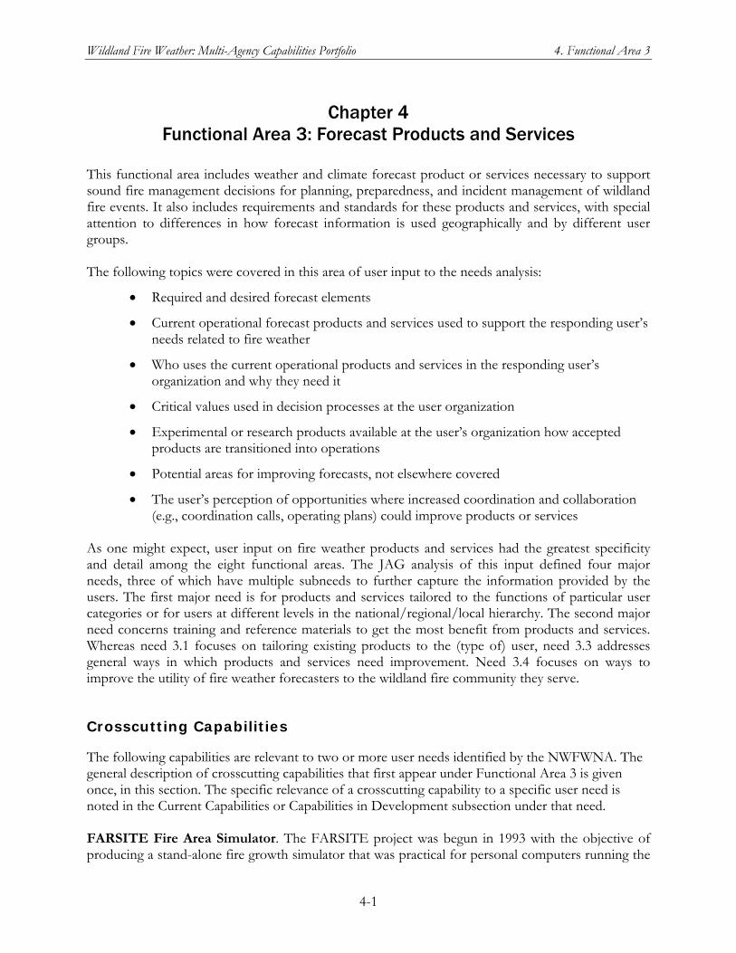
Wildland Fire Weather: Multi-Agency Capabilities Portfolio 4. Functional Area 3
4-1
Chapter 4 Functional Area 3: Forecast Products and Services
This functional area includes weather and climate forecast product or services necessary to support sound fire management decisions for planning, preparedness, and incident management of wildland fire events. It also includes requirements and standards for these products and services, with special attention to differences in how forecast information is used geographically and by different user groups. The following topics were covered in this area of user input to the needs analysis:
Required and desired forecast elements
Current operational forecast products and services used to support the responding user’s needs related to fire weather
Who uses the current operational products and services in the responding user’s organization and why they need it
Critical values used in decision processes at the user organization
Experimental or research products available at the user’s organization how accepted products are transitioned into operations
Potential areas for improving forecasts, not elsewhere covered
The user’s perception of opportunities where increased coordination and collaboration (e.g., coordination calls, operating plans) could improve products or services
As one might expect, user input on fire weather products and services had the greatest specificity and detail among the eight functional areas. The JAG analysis of this input defined four major needs, three of which have multiple subneeds to further capture the information provided by the users. The first major need is for products and services tailored to the functions of particular user categories or for users at different levels in the national/regional/local hierarchy. The second major need concerns training and reference materials to get the most benefit from products and services. Whereas need 3.1 focuses on tailoring existing products to the (type of) user, need 3.3 addresses general ways in which products and services need improvement. Need 3.4 focuses on ways to improve the utility of fire weather forecasters to the wildland fire community they serve.
Crosscutting Capabilities
The following capabilities are relevant to two or more user needs identified by the NWFWNA. The general description of crosscutting capabilities that first appear under Functional Area 3 is given once, in this section. The specific relevance of a crosscutting capability to a specific user need is noted in the Current Capabilities or Capabilities in Development subsection under that need. FARSITE Fire Area Simulator. The FARSITE project was begun in 1993 with the objective of producing a stand-alone fire growth simulator that was practical for personal computers running the
Wildland Fire Weather: Multi-Agency Capabilities Portfolio 4. Functional Area 3
4-2
Windows operating system. The current FARSITE program is officially a National system and is supported by the Fire Applications Support desk at the NIFC in Boise. The motivation for developing FARSITE was to incorporate in one simulation environment all of the then-operational fire behavior models, including surface fire, crown fire, spotting, fuel moisture, fire acceleration, and fuel consumption. Individually, the basic fire behavior models incorporated into FARSITE are classified as point-based or one-dimensional models because they produce fire spread rates, directions, and spread or spotting distances, based on properties of the environment obtained from one point on the ground at one point in time. The FARSITE goal was to adapt these existing fire behavior models to run in a two-dimensional simulation environment.
Fire growth simulation in FARSITE requires spatial data on fuels, topography, and weather, all of which are required as inputs to the basic constituent fire behavior models. When these inputs are combined into FARSITE, the simulation generates fire growth and behavior in two dimensions, using the varying values of the environment to calculate fire progress over time and space. This fire progression can be animated to show fire moving over landscapes. After the third release of FARSITE in 2007, the program offers all the intended features and is no longer being modified except for bug fixes. However, a full revision of the program is needed to bring the graphical user interface up to modern standards. The program and user documentation is distributed free over the internet. Interagency Fuels Treatment Decision Support System (IFT-DSS). One of the more pressing problems facing fire and fuels managers is the confusion and inefficiency associated with the many existing software systems intended to help fire and fuels managers. These systems have proliferated in the last decade in response to various funding initiatives without any central control or vision. Managers are left with an assortment of unconnected systems in various stages of development with little guidance concerning the strengths and weaknesses of the various systems, and no framework for integration and fusion of data and outputs from these systems. The IFT-DSS, a JFSP-funded project, is intended to support interagency fuels treatment planning, including analysis of vegetation effects related to the wildlife habitat. When completed, it will provide a rich assortment of fully-operational and fully-supported services that operate in a web-based environment with a single-user interface. Among the target users of IFT-DSS are fuels and wildlife specialists, who can employ it jto assist with fire and fuels-related planning. The results from IFT-DSS can be used to support and
FARSITE fire area simulator
PC program Fire growth simulation Spatial fuel and terrain data needed Weather and fuel moisture change with time Used to project fire growth of ongoing fires and hypothetical fires for planning, and more
Wildland Fire Weather: Multi-Agency Capabilities Portfolio 4. Functional Area 3
4-3
explain recommendations made to decisionmakers and to document that full consideration and evaluation of treatment units has been done within a relevant geoscape. NWCG Training and Distance Learning. The NWCG Training Working Team manages the NWCG training curricula, recommends for approval by the NWCG changes to the Wildland Fire curriculum, oversees NWCG course revisions, recommends to the NWCG course development and format standards, oversees quality assurance for all training materials developed by NWCG so that they meet the Course Development and Format Standards; and provides guidance to other teams on the course development process and standards. This working team currently provides distance learning courses online and by compact disk (CD). To expedite training and reduce the costs of tuition and travel for the wildand fire community, an initiative is underway to review the Wildland Fire curriculum to determine the feasibility of making full courses or portions of courses available online. To help make basic wildfire classroom training more accessible, an interagency group of local, state and federal agencies has, begun offering online classes on Wildland Fire Behavior and on Basic Strategies and Tactics for Fighting Wildfires. The courses were developed cooperatively by the NWCG and the U.S. Fire Administration's National Fire Academy. The goal was to make the information available to new recruits, wherever they are, when they need it. Officials also hope that access to distance learning offerings will help others who are interested, including homeowners living in or at the edges of forests, to learn the most effective approaches to wildfire management. Making the coursework available online should allow small and rural fire departments to enhance their firefighters’ training more quickly and in response to surge demand for firefighting capability. There is generally no shortage of firefighters, but in the past access to training that could improve skill level was limited, especially for training candidates living in rural areas, who would have to travel to take courses in a traditional classroom setting. NWS Environmental Modeling Center. The mission of the Environmental Modeling Center (EMC), one of NOAA/NWS National Centers for Environmental Prediction, is to improve NCEP’s numerical model–based predictions of weather, climate, and hydrology through transitioning the results of R&D in areas such as computer modeling and data assimilation into operational products and services. The Environmental Modeling Program of the EMC has been called “one of the cornerstones supporting NOAA’s mission to understand and predict changes in the Earth’s environment.” EMC currently has efforts to support fire weather by improving the resolution of fire weather forecast models. This project “proposes to fund the development and implementation of high resolution (…to less than 1 km by 2015 and beyond) coupled fire-weather models.” This project also seeks to provide improved modeling and predictive support to IMETs. NWS Fire Weather Point Forecast Matrix (PFM). This web-based experimental product available across the NWS Western Region, is based on the standard public Point Forecast Matrix product produced by the NWS for the past several years. Weather forecasts for the next 7 days are produced, with updates for the first 3 days every three hours and every six hours for the last 4 days. One key difference from the standard PFM is that the fire weather PFM adds forecasts for weather parameters specifically used by fire agencies, including lightning activity level (LAL), Haines Index, and smoke management variables. A second difference is that production of the fire weather PFM is dynamic. A web user can click anywhere on a map representing the WFO County Warning Area and, within a few seconds, receive a PFM generated from the latest grids available on the Western Region server.
Wildland Fire Weather: Multi-Agency Capabilities Portfolio 4. Functional Area 3
4-4
Also, since 2003 a number of NWS WFOs are offering an experimental tool, the Weather Activity Planner. This tool provides customers a way to identify time periods when certain user-specified weather thresholds will be met out to seven days. NWS Fire Weather Training for WFO & IMET. The NWS offers a variety of distance-learning and in-residence training courses on fire weather, as well as annual Incident Meteorologist (IMET) workshops to maintain a fully trained cadre of IMETs. To be a certified NWS Fire Weather Forecaster, NWS meteorologists must be trained to complete the core set of fire weather products by completing the NWS Fire Weather Computer-Based Learning module and S-290, Intermediate Wildland Fire Behavior Course. Fire Weather Program Leaders must also complete the S-591, Advanced Fire Weather Forecasters Course. Meteorologists who issue NFDRS forecasts (the FWM product, which provides weather inputs to the NFDRS software) are encouraged to review course material for S-491, NFDRS. Access to these training courses (except the IMET workshops) can be obtained via the NWS fire weather meteorologists at the NIFC in Boise, Idaho. NWS NFDRS Weather Input Verification Program. In NWS Western Region, a number of WFOs collect and report verification statistics for the NFDRS forecasts (product FWM) they issue. The FWM is a special-use product that provides weather forecast parameters used as input to the daily NFDRS computer run conducted by the NICC at the National Computer Center in Kansas City. The verification statistics measure forecast quality for temperature, relative humidity, and wind speed in terms of a computed figure of merit, “forecast improvement over persistence.” In addition to providing these verification statistics to FWM users, the WFOs report them in their Fire Weather Program Annual Operating Plan, submitted to Western Region Headquarters. For more information on NFDRS, see the entry for “WFAS and NFDRS” below in this section. NWS Storm Prediction Center. The Storm Prediction Center (SPC), which is one of the centers within the NOAA/NWS National Centers for Environmental Prediction, focuses on hazardous weather events such as severe thunderstorms, tornadoes, extreme winter weather, and excessive precipitation, as well as fire weather. The emphasis in SPC forecasts is on the forecast period from 2–8 hours out to the next 6–72 hours. The SPC issues 1- and 2-day Fire Weather Outlooks for the continental United States. These forecasts define areas with critical and extremely critical fire conditions and potential, as well as dry thunderstorm conditions and potential. Since June 2007, a 3–8 day Fire Weather Outlook has been available as an official product on the SPC website at http://www.spc.noaa.gov/products/exper/fire_wx/. NWS WFO Fire Weather Products and Services. In accordance with Section VI, “Joint Responsibilities” of the 2008 Interagency Agreement between NOAA/NWS and the Wildland Fire Agencies, and NWS Policy Directive 10-4, “Products and Services to Support Fire and Other Incidents,” every NWS WFO that supplies Fire Weather Program products and services for its local service area documents these products and services in an Annual Operating Plan (AOP) (Interagency Agreement 2008, NWS 2009a). The types of products and services, the number of nonroutine products and services provided annually in response to user requests, and the extent of product and service development to meet local needs vary among the WFOs and from one NWS region to another. NWS Western Region Headquarters and various Western Region WFOs have been particularly active in supporting their wildland fire management communities and initiating improvements in products and services. Typically these innovations are extensions and improvements on the centralized guidance or other standard products and services provided by
Wildland Fire Weather: Multi-Agency Capabilities Portfolio 4. Functional Area 3
4-5
NWS national capabilities. Where the capabilities review has identified a WFO-developed product or service of special relevance to meeting a User need identified in the NWFWNA, an item for it has been included under the Current Capabilities for that User Need. UCAR/COMET Fire Weather Courses. In 1989 UCAR and NOAA/NWS established the Cooperative Program for Operational Meteorology, Education and Training (COMET) to promote a better understanding of mesoscale meteorology and to maximize the benefits of new weather technologies. The COMET staff includes meteorologists, hydrologists, computer scientists, graphic artists, and instructional designers, as well as administrative, information technology, and quality assurance specialists. Today the COMET Program addresses education and training needs in the atmospheric and related sciences through three main activities:
Distance Education. COMET produces and delivers online, interactive professional development materials that also serve as readily available reference resources. The majority of these are available at no cost on the UCAR/Comet MetEd Website, www.meted.ucar.edu/.
Residence Classes. COMET offers advanced hydrometeorological education for the working professional in a classroom and forecasting laboratory environment at the COMET facility in Boulder, Colorado.
Outreach Program. With funding from the NWS and other agencies, COMET provides financial support to universities for applied research projects conducted in collaboration with local WFOs. These projects promote the transfer of science to practice and serve the public good.
UCAR and COMET produce training modules for fire weather, which can be accessed via the COMET website: www.comet.ucar.edu/index.htm. Among the relevant offerings are the following:
UCAR Wildfire Backgrounder. A basic tutorial covering various aspects of wildfires, including: (1) what shapes a wildland fire (fuels, topography, and weather), (2) smoke and toxins, (3) climate change, and 4) people and development.
COMET Introduction to Fire Behavior: Influences of Topography, Fuels, and Weather on Fire Ignition and Spread. This website provides an overview of factors that affect the ignition and spread of wildfire. Information is presented with 3-dimensional graphics and animations as well as audio descriptions and commentary provided by a fire behavior expert.
COMET Intermediate Wildland Fire Behavior Course. Intermediate Wildland Fire Behavior, S-290, is the second course in a five course sequence developing wildland fire behavior prediction skills and knowledge. In the Wildland Fire Qualifications System, this course is required of those planning to work as a Firefighter Type 1 or a Fire Effects Monitor on wildfires, fire use fires, and prescribed fires. It builds upon the basics in S-190, Introduction to Wildland Fire Behavior, but with more detailed information about characteristics and interactions of the wildland fire environment (fuels, weather, and topography) that affect wildland fire behavior for safety purposes.
COMET Advanced Fire Weather Forecaster Course. This course addresses advanced training needs of NWS IMETs, Fire Weather Program Leaders in NOAA's
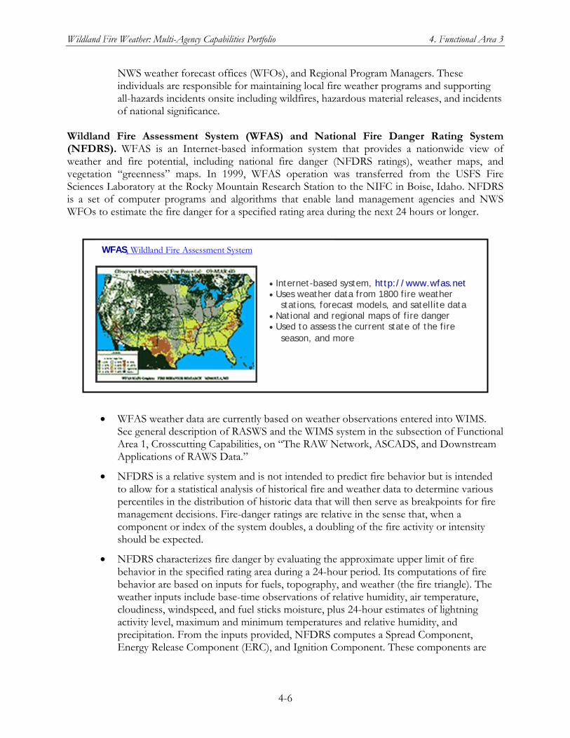
Wildland Fire Weather: Multi-Agency Capabilities Portfolio 4. Functional Area 3
4-6
NWS weather forecast offices (WFOs), and Regional Program Managers. These individuals are responsible for maintaining local fire weather programs and supporting all-hazards incidents onsite including wildfires, hazardous material releases, and incidents of national significance.
Wildland Fire Assessment System (WFAS) and National Fire Danger Rating System (NFDRS). WFAS is an Internet-based information system that provides a nationwide view of weather and fire potential, including national fire danger (NFDRS ratings), weather maps, and vegetation “greenness” maps. In 1999, WFAS operation was transferred from the USFS Fire Sciences Laboratory at the Rocky Mountain Research Station to the NIFC in Boise, Idaho. NFDRS is a set of computer programs and algorithms that enable land management agencies and NWS WFOs to estimate the fire danger for a specified rating area during the next 24 hours or longer.
WFAS weather data are currently based on weather observations entered into WIMS. See general description of RASWS and the WIMS system in the subsection of Functional Area 1, Crosscutting Capabilities, on “The RAW Network, ASCADS, and Downstream Applications of RAWS Data.”
NFDRS is a relative system and is not intended to predict fire behavior but is intended to allow for a statistical analysis of historical fire and weather data to determine various percentiles in the distribution of historic data that will then serve as breakpoints for fire management decisions. Fire-danger ratings are relative in the sense that, when a component or index of the system doubles, a doubling of the fire activity or intensity should be expected.
NFDRS characterizes fire danger by evaluating the approximate upper limit of fire behavior in the specified rating area during a 24-hour period. Its computations of fire behavior are based on inputs for fuels, topography, and weather (the fire triangle). The weather inputs include base-time observations of relative humidity, air temperature, cloudiness, windspeed, and fuel sticks moisture, plus 24-hour estimates of lightning activity level, maximum and minimum temperatures and relative humidity, and precipitation. From the inputs provided, NFDRS computes a Spread Component, Energy Release Component (ERC), and Ignition Component. These components are
Internet-based system, http://www.wfas.net Uses weather data from 1800 fire weather stations, forecast models, and satellite data National and regional maps of fire danger Used to assess the current state of the fire season, and more
WFAS, Wildland Fire Assessment System
Wildland Fire Weather: Multi-Agency Capabilities Portfolio 4. Functional Area 3
4-7
then used to derive an Occurrence Index, Burning Index, and Fire Load Index for the rating area.
The NFDRS calculations for WFAS are performed at the National Computer Center at Kansas City (NCC-KC). The fuel model, index, and fire danger levels are set by local managers. National WFAS maps are produced from fire danger levels using simple inverse distance square interpolation. Satellite "greenness" products are currently stand-alone indicators of fire potential and not integrated into the calculations except for experimental projects.
Each day during fire season, national maps of selected fire weather parameters and NFDRS output indices are produced for WFAS by WFAS-MAPS, located at the USFS Rocky Mountain Research Station.
Various NWS WFOs provide weather forecast inputs for NFDRS runs in a special-use formatted product called the NFDRS Forecast (FWM). See capability description for “NWS NFDRS Weather Information Verification Program” above in this section for details on verification of FWM weather forecast data.
Wildland Fire Decision Support System (WFDSS). The WFDSS is intended to assist fire managers and analysts in making strategic and tactical decisions for fire incidents. It was conceived in June 2005 as a scalable decision support system that would use appropriate fire behavior modeling, economic principles, and information technology to support effective wildland fire decisions consistent with the resources and fire management plans of the wildland management agencies. WFDSS was designed to replace the 30-year-old Wildland Fire Situation Analysis system, as well as the processes required under the Wildland Fire Implementation Plan and the Long-Term Implementation Plan. WFDSS provide the following advantages and advances over the systems it replaces:
Combines desktop applications for fire modeling into a web-based system for easier data acquisition
Provides an easy way for fire managers and analysts to accurately document their decisionmaking process by allowing results of analyses to be attached to the decision point and included in the final incident report
Provides one decision process and documentation system for all types of wildland fires
Is a web-based application for easier sharing of analyses and reports across all levels of the Federal wildland fire organization
Introduces economic principles into the fire decision process For access to WFDSS and more information about its development, availability, and current status, see the WFDSS website at http://wfdss.usgs.gov.
3.1 Improved forecast products and services are needed across duty functions and at each level of government to meet the widely varying needs of fire operators and managers.
Wildland Fire Weather: Multi-Agency Capabilities Portfolio 4. Functional Area 3
4-8
Products must be made available in GIS format, in gridded digital format, and in graphic display format as appropriate, and with uncertainty information (probabilistic confidence limits) as applicable. Users also preferred that forecasts generally go out at least 72 hours, with information available in one hour increments. Additionally, users like the use of gridded forecasts, and desire a similar 72 hour range, with 1 hour time steps, plus horizontal resolutions of 1 to 4 km to make the best use of the products when considering local affects. Furthermore many users supported the use of digital probabilistic data and forecasts for their operations. Users considered the following products to be very important: NWS fire weather forecasts; red flag warnings; fire weather watches; spot forecasts; fire danger forecasts; NFDRS forecasts; 7-day fire significant potential; smoke dispersion / ventilation / transport forecasts; fuel moisture forecasts; satellite imagery (infrared and water vapor); seasonal weather outlook; and drought forecasts. Users considered the following products to be moderately important: monthly fire outlooks, smoke concentration forecasts, seasonal fire outlooks, mountain wind patterns, and stagnation advisories. Users considered two products to be of particularly poor accuracy and availability: smoke concentration forecasts and smoke dispersion/ventilation/transport forecasts. Users desire better use of radio broadcasts to alert them concerning weather conditions that affect wildland fires. Suggestions include descriptions of which parameters are important for the current fire forecast conditions, along with the time of day for each of these conditions.
3.1.a Managers at each level of government need tailored products and tools for their unique duties and responsibilities; these products need to be made available to the entire community for greater use and awareness.
DESCRIPTION OF THE NEED
Products to be considered are varied, but each level of user requires a basic product set which identifies fire threat and primary environmental conditions (weather, fuels, etc.). It is vital that these products be tailored for different types of users and that they be made available to these users. The products also must be clearly labeled to ensure they are used as intended and to minimize misinterpretation. For example, strategic-level products are great for strategic planning, but must be easy to find and clearly distinguishable from tactical-level products to facilitate their use by their intended audience. One aspect of this need is the requirement for NWS Spot Forecasts, or similar products, to be made available to state and local government personnel, in the same way that Spot Forecasts are made available to public safety officials, so that they can effectively perform their roles and responsibilities. Spot Forecasts are an important tool, highly valued by large segments of the fire community, but a broader approach is required regarding their issuance and dissemination.
Wildland Fire Weather: Multi-Agency Capabilities Portfolio 4. Functional Area 3
4-9
CURRENT CAPABILITIES
DRI-CEFA. See general description of DRI-CEFA under Crosscutting Capabilities for Functional Area 1. A CEFA mission area is developing decision-support tools for the fire community and helping to translate science for decisionmakers. Current operational products at CEFA relevant to User Needs 3.1 and 3.1.a include the 7-day RAWS-MOS forecasts for GACC Predictive Services, 15-day standardized ERC for National Predictive Services, 72-hour forecasts of fire weather and smoke concentration and transport for CANSAC, hourly fire danger for California FIRESCOPE, and the National BlueSky products for smoke concentration and transport, mixing height, ventilation index, and raw model output, which are produced for GACC Predictive Services. FARSITE Fire Area Simulator. See general description under Crosscutting Capabilities for Functional Area 3. FCAMMS. See general description under Other Crosscutting Current Capabilities for Functional Area 1. NSF Research Grant: Data Dynamic Simulation for Disaster Management. See general descriptions of NSF research grants and this individual grant under Crosscutting Capabilities for Functional Area 2. The dynamic simulation capability being tested under this grant could, if transitioned to operations, provide high-resolution forecasts of fire weather and fire behavior for specific wildland fire incidents. NCAR. See general description of NCAR under Crosscutting Capabilities for Functional Area 2. NCAR has played a lead role in development of WRF [Weather Research and Forecasting], a mesoscale forecast modeling environment that has been used to develop a new generation of modes being run at national operational processing centers. The WRF-Fire model, developed by NCAR, is decribed under User Need 2.1.a. NICC/GACC Predictive Services Units. See general description under Crosscutting Capabilities for Functional Area 1. Predictive Services has some capability now to tailor products for different management levels and is actively expanding that capability. NWS Fire Weather Point Forecast Matrix (PFM). See general description under Crosscutting Capabilities for Functional Area 3. The Fire Weather PFM, allows any wildland fire community user with web access to obtain a 7-day forecast, which includes parameters of particular relevance to fire management, for a point selected on a County Warning Area map. NWS Storm Prediction Center. See general description under Crosscutting Capabilities for Functional Area 3. NWS WFO Fire Weather Products and Services. See general description under Crosscutting Capabilities for Functional Area 3. Of particular relevance to User Need 3.1 and 3.1.a are the following activities:
NWS Western Region WFOs are providing data support by request for the FARSITE fire behavior and growth simulator. This support is provided via the local WFO’s fire
Wildland Fire Weather: Multi-Agency Capabilities Portfolio 4. Functional Area 3
4-10
weather web page and uses data from the NWS National Digital Forecast Database (NDFD).
Following the 2001 report endorsed by the WGA and the wildland fire agencies, A Collaborative Approach for Reducing Wildland Fire Risks to Communities and the Environment, the wildland fire agencies, via the GACCs, expressed the need for fire weather gridded data in a GIS-friendly format. In response, NWS Southern Region Headquarters and Western Region Headquarters developed a method to produce GIS shapefiles for use by the GACCs and host them on a server located at Western Region Headquarters. The server, which was purchased with funds from OCWWS, is maintained by Western Region Headquarters. The fire weather element shapefiles, which initially covered west Texas, New Mexico and Arizona, are now available for all of the NWS Western Region, New Mexico, and west Texas. The 2.5 km resolution files are generated from netCDF files from the WFOs (not from the NDFD). The fire weather GIS shapefiles are available online at www.wrh.noaa.gov/gis/. Progress continues to be made on implementing fire weather elements in NDFD. Contingent on negotiations with NWSEO, implementation is planned no later than the end of fiscal year 2010.
ROMAN. See general description of ROMAN in the subsection of Functional Area 1, Crosscutting Capabilities, on “The RAWS Network, ASCADS, and Downstream Applications of RAWS Data.” With respect to User Need 3.1.a, ROMAN was a major improvement in making RAWS and other weather mesonet data available to the entire wildland fire community. Still to be evaluated is how well ROMAN meets the first part of User Need 3.1.a: tailoring products and tools to fire managers’ unique duties and responsibilities. WFAS and NFDRS. See general description under Crosscutting Capabilities for Functional Area 3.
CAPABILITIES IN DEVELOPMENT
NCAR. See general description of NACAR under Crosscutting Capabilities for Functional Area 3. NCAR has tested coupled weather–fire models in an operational setting to demonstrate the capability to apply more sophisticated models in real-time applications. SDSMT Curriculum in Wildfire Management. See general description under Crosscutting Capabilities for Functional Area 2. WFDSS. See general description under Crosscutting Capabilities for Functional Area 3. WRAP. See general description of WRAP under Crosscutting Capabilities in Development for Functional Area 1. WRAP provides a program base for developing improved forecast products and services tailored to the needs of fire operators and managers at multiple levels.
CHALLENGES TO MEETING THE NEED
Coordination – Not getting coordinated requirements documented for future needs and smoke management.
Wildland Fire Weather: Multi-Agency Capabilities Portfolio 4. Functional Area 3
4-11
Data – Model data needs to be downscaled to resolution needed by fire fighters using an increase in computing resources. Processes – Requirement definition and feedback procedures need to be accelerated from land management agencies to NOAA. Also, the NWS must acquire much improved ability to respond, as an agency, to quickly arising needs that match customers’ expectations. Resources – Proposals need funding for improvement. IT resources need to be secured for the national fire program.
3.1.b Information on forecast product accuracy should be made available to users.
DESCRIPTION OF THE NEED
Users require information on forecast accuracy in order to make informed decisions about their use of current forecasts. Forecast production centers routinely produce and track this information in order to monitor and improve their technical proficiency. This information must be made available to the user community in easy-to-understand formats, so the community can better understand product accuracy along with product accuracy change over time.
CURRENT CAPABILITIES
DRI-CEFA. See general description under Other Crosscutting Current Capabilities for Functional Area 1. With respect to User Need 3.1.b, CEFA has been developing real-time verification for the RAWS-MOS product described in Section 2.3. FCAMMS. See general description of FCAMMS under Other Crosscutting Current Capabilities for Functional Area 1. FCAMMS research attempts to quantify all of the uncertainties affecting a forecast in the decision space of the user. As users are directly involved in the validation phase of FCAMMS model development, those users acquire a working understanding of model accuracy. The challenge for FCAMMS developers and adapters is to communicate that degree of working understanding to the larger user community, as not all users will have been involved in developing a particular model. NICC/GACC Predictive Services Units. See general description of Predictive Services under Other Crosscutting Current Capabilities for Functional Area 1. Relevant to User Need 3.1.b, Predictive Services has a website through DRI for forecast verification of the Seven-day fire outlook product. NWS NFDRS Weather Input Verification Program. See general description under Crosscutting Capabilities for Functional Area 3. RMRS Fire, Fuel and Smoke Program. See general description of the Forest Service RMRS under Crosscutting Capabilities for Functional Area 2.
Wildland Fire Weather: Multi-Agency Capabilities Portfolio 4. Functional Area 3
4-12
CAPABILITIES IN DEVELOPMENT
Nothing identified at this time
CHALLENGES TO MEETING THE NEED
Coordination – need to define critical weather parameter thresholds with users. Data – improved quality control of RAWS observation data. Resources – give users access to NWS verification data. Processes – develop new verification system using defined thresholds per 3a. Science – research on defining critical weather parameter thresholds for fire behavior.
3.1.c Users need more detailed information regarding long-term forecasts and climate outlooks.
DESCRIPTION OF THE NEED
Users’ decisions are based upon an understanding of various climatic elements and their impacts on wildland fire requirements. It is therefore important that climate-related products explain what the predominant meteorological drivers are for the end results.
CURRENT CAPABILITIES
DRI-CEFA. See general description under Other Crosscutting Current Capabilities for Functional Area 1. With respect to this User Need, CEFA has a project to link the NOAA Climate Forecast System and the ESRL reforecast models to a biogeophysical model developed at Oregon State University for the Forest Service. The purpose is to produce experimental seasonal forecasts of vegetation stress, where the stress index is linked to specific fire management activities. Also, CEFA is co-organizer of the Predictive Services National Seasonal Assessment Outlooks, which produces seasonal significant fire potential outlooks. FCAMMS. See general description under Other Crosscutting Current Capabilities for Functional Area 1. FCAMMS is enabling research attempting to derive new relationships that can be used in making more detailed seasonal assessments while continuously evaluating previously derived relationships. NICC/GACC Predictive Services Units. See general description of Predictive Services under Other Crosscutting Current Capabilities for Functional Area 1. Predictive Services produces a long-term forecast and is working with the NWS Climate Prediction Center on refinements and improvements to it. Predictive Services also works with the NWS Climate Data Center to develop a better understanding of seasonal, annual, and longer-term trends in precipitation and other factors affecting fire potential and fire behavior.
Wildland Fire Weather: Multi-Agency Capabilities Portfolio 4. Functional Area 3
4-13
NWS Climate Prediction Center. The NWS Climate Prediction Center (CPC) provides an array of long-term forecasts and climate outlooks, mainly for temperature and precipitation on its website at http://www.cpc.ncep.noaa.gov/: These products include a 6–10 Day Outlook, 8–14 Day Outlook, Monthly Outlook, and Three–Month Outlook. NWS/CPC also issues two-week Hazard Assessment forecast maps for precipitation, temperature/wind, and soil/wildfire and provides outlooks for short-term and long-term drought conditions. Jointly with the U.S. Department of Agriculture and the National Drought Mitigation Center, it issues the weekly Drought Monitor, which is used nationally to identify areas of drought. NOAA also provides the Palmer Drought Severity Index, which particularly effective for determining long-term drought east of the Continental Divide. NWS Fire Weather Point Forecast Matrix. See general description under Crosscutting Capabilities for Functional Area 3. NWS Storm Prediction Center. See general description under Crosscutting Capabilities for Functional Area 3. The 3–8 day Fire Weather Outlook is the longest-term forecast product currently issued by the NWS/SPC. However, see the longer-term products from the Climate Prediction Center. UCAR/COMET Fire Weather Courses. See general description under Crosscutting Capabilities for Functional Area 3. Effects of climate cycles and long-term climate trends are covered in some of the COMET offerings.
CAPABILITIES IN DEVELOPMENT
SDSMT Curriculum in Wildfire Management. See general description under Crosscutting Capabilities for Functional Area 2.
CHALLENGES TO MEETING THE NEED
Coordination – efforts to improve long-term forecasts and climate outlooks Science – how to provide long-term forecasts of desired fire weather elements? Data – long-term forecasts of additional elements will require additional quality control input data.
3.2 Users need improved training and reference materials that facilitate proper interpretation and use of forecast products, as well as improved access to this material.
Many users expressed concerns regarding the appropriate use of various products and services. Lack of references and proper training result in confusion as to which products are best for certain circumstances. Additionally, this extends to correct use of the various products as well. Underlying assumptions and information on product usage would greatly benefit the community.
3.2.a Existing training and reference material for products and services need to be made readily available to all interested users.
Wildland Fire Weather: Multi-Agency Capabilities Portfolio 4. Functional Area 3
4-14
DESCRIPTION OF THE NEED
Users urgently require improved access to online training and reference material to enable them to make appropriate use of all available products and services. These materials must be readily available and must describe underlying assumptions (forecast-based and/or model-based) that went into the development of the various products. Furthermore, these references should include information on product timeliness, which also includes information on the timeliness of the data that went into the product. All of this will better enable users to appropriately use and adapt forecasts, based upon the most current environmental information, to meet their requirements.
CURRENT CAPABILITIES
DRI-CEFA. See general description of DRI-CEFA under Other Crosscutting Current Capabilities for Functional Area 1. CEFA provides a faculty member for the advanced course on the NFDRS. These lectures include an overview of climatology, links between climate and fire danger, and methods to analyze fire weather data for fire danger rating areas. NICC/GACC Predictive Services Units. See general description of Predictive Services under Other Crosscutting Current Capabilities for Functional Area 1 and the description of the Predictive Services Program in chapter 1, Introduction. Many Predictive Services products have accompanying information on how to interpret and use that product. Predictive Services is developing short podcasts, intended for the broad wildland fire community, that describe its products and services. NWCG Training and Distance Learning. See general description under Crosscutting Capabilities for Functional Area 3. NWS Fire Weather Training for WFO & IMET. See general description under Crosscutting Capabilities for Functional Area 3. UCAR/COMET Fire Weather Courses. See general description under Crosscutting Capabilities for Functional Area 3. Wildland Fire Lessons Learned Center. See general discussion under Crosscutting Capabilities for Functional Area 2. The operations-oriented classroom, distance-learning, and website-based training and information dissemination capabilities of the center are relevant to User Need 3.2 generally and to User Need 3.2.a for ensuring that interested members of the operational community have access to training and reference materials on forecast products and services.
CAPABILITIES IN DEVELOPMENT
WFDSS. See general description under Crosscutting Capabilities for Functional Area 3.
CHALLENGES TO MEETING THE NEED
Coordination – efforts to enhance improvements and availability of training and reference material. Resources – Updating and Upgrading of training efforts need to be fully funded.
Wildland Fire Weather: Multi-Agency Capabilities Portfolio 4. Functional Area 3
4-15
3.2.b Training and reference material for products and services need to be improved and expanded, based upon proven best practices from the field.
DESCRIPTION OF THE NEED
Training and reference materials should provide simple explanations concerning product applicability and use. Clear explanations of how parameters are depicted, couched in terms understood by the target user community, are essential. This information should include as much information as possible about product strengths and weaknesses, and in what type of conditions the product is ideal for. Furthermore, this should include detailed underlying assumptions that went into the development of the product so that users would know when the product is not well-suited for its current application. These training and references need to also include information on standard production timelines so that users know when the products should be available and what data (observed and/or model), with appropriate data cut-off times went into the development of it.
CURRENT CAPABILITIES
NWCG Training and Distance Learning. See general description under Crosscutting Capabilities for Functional Area 3. NWS Fire Weather Training for WFO & IMET. See general description under Crosscutting Capabilities for Functional Area 3. UCAR/COMET Fire Weather Courses. See general description under Crosscutting Capabilities for Functional Area 3. Wildland Fire Lessons Learned Center. See general discussion under Crosscutting Capabilities for Functional Area 2. As a Lessons Learned Center accepted in the community, this capability is particularly relevant to User Need 3.2.b.
CAPABILITIES IN DEVELOPMENT
DRI-CEFA. See general description of DRI-CEFA under Other Crosscutting Current Capabilities for Functional Area 1. CEFA is planning a workshop for Long-Term Analysts on sources and uses of climate data and information. NICC/GACC Predictive Services Units. See general description of Predictive Services under Other Crosscutting Current Capabilities for Functional Area 1 and the description of the Predictive Services Program in chapter 1, Introduction. Predictive Services is developing short podcasts, intended for the broad wildland fire community, that describe its products and services. WFDSS. See general description under Crosscutting Capabilities for Functional Area 3.
Wildland Fire Weather: Multi-Agency Capabilities Portfolio 4. Functional Area 3
4-16
CHALLENGES TO MEETING THE NEED
Coordination – Processes – Resources – Updating and Upgrading of training efforts need to be fully funded.
3.2.c Training and information on interpretation and use should accompany all products and services, especially as new ones are implemented.
DESCRIPTION OF THE NEED
The community needs more information regarding how products are designed to be used. This includes a need for information regarding how products are developed and what elements are used or considered when developing a product. For example, if a wildland fire threat product only includes certain types of fuels, the community needs to know that, so they can factor that information into their decision making processes. This is especially important for the community in situations where one product is not well suited for that situation but another product is.
CURRENT CAPABILITIES
DRI-CEFA. See general description of DRI-CEFA under Other Crosscutting Current Capabilities for Functional Area 1. CEFA co-organizes training for Predictive Services meteorologists and Wildfire intelligence officers at the National Seasonal Assessment Workshops, where the seasonal significant fire potential outlooks are produced. UCAR/COMET Fire Weather Courses. See general description under Crosscutting Capabilities for Functional Area 3.
CAPABILITIES IN DEVELOPMENT
NICC/GACC Predictive Services Units. See general description of Predictive Services under Other Crosscutting Current Capabilities for Functional Area 1 and the description of the Predictive Services Program in chapter 1, Introduction. Predictive Services is developing short podcasts, intended for the broad wildland fire community, that describe its products and services. NWS Fire Weather Training for WFO & IMET. See general description under Crosscutting Capabilities for Functional Area 3. WFDSS. See general description under Crosscutting Capabilities for Functional Area 3.
CHALLENGES TO MEETING THE NEED
Coordination – Resources – Updating and Upgrading of training efforts need to be fully funded.
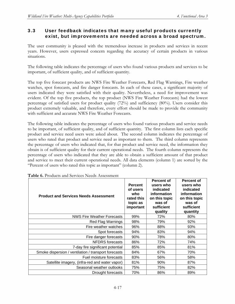
Wildland Fire Weather: Multi-Agency Capabilities Portfolio 4. Functional Area 3
4-17
3.3 User feedback indicates that many useful products currently exist, but improvements are needed across a broad spectrum.
The user community is pleased with the tremendous increase in products and services in recent years. However, users expressed concern regarding the accuracy of certain products in various situations. The following table indicates the percentage of users who found various products and services to be important, of sufficient quality, and of sufficient quantity. The top five forecast products are NWS Fire Weather Forecasts, Red Flag Warnings, Fire weather watches, spot forecasts, and fire danger forecasts. In each of these cases, a significant majority of users indicated they were satisfied with their quality. Nevertheless, a need for improvement was evident. Of the top five products, the top product (NWS Fire Weather Forecasts) had the lowest percentage of satisfied users for product quality (72%) and sufficiency (80%). Users consider this product extremely valuable, and therefore, every effort should be made to provide the community with sufficient and accurate NWS Fire Weather Forecasts. The following table indicates the percentage of users who found various products and service needs to be important, of sufficient quality, and of sufficient quantity. The first column lists each specific product and service need users were asked about. The second column indicates the percentage of users who rated that product and service need as important to them. The third column represents the percentage of users who indicated that, for that product and service need, the information they obtain is of sufficient quality for their current operational needs. The fourth column represents the percentage of users who indicated that they are able to obtain a sufficient amount of that product and service to meet their current operational needs. All data elements (column 1) are sorted by the “Percent of users who rated this topic as important” (column 2). Table 6. Products and Services Needs Assessment
Product and Services Needs Assessment
Percent of users
who rated this topic as
important
Percent of users who indicated
information on this topic
was of sufficient
quality
Percent of users who indicated
information on this topic
was of sufficient quantity
NWS Fire Weather Forecasts 99% 72% 80% Red Flag Warnings 98% 79% 92%
Fire weather watches 96% 88% 93% Spot forecasts 94% 83% 94%
Fire danger forecasts 90% 78% 80% NFDRS forecasts 86% 72% 74%
7-day fire significant potential 85% 85% 81% Smoke dispersion / ventilation / transport forecasts 84% 67% 70%
Fuel moisture forecasts 83% 56% 58% Satellite imagery, (infra-red and water vapor) 81% 90% 87%
Seasonal weather outlooks 75% 75% 82% Drought forecasts 70% 86% 89%
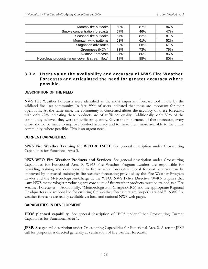
Wildland Fire Weather: Multi-Agency Capabilities Portfolio 4. Functional Area 3
4-18
Monthly fire outlooks 60% 87% 84% Smoke concentration forecasts 57% 46% 47%
Seasonal fire outlooks 57% 82% 81% Mountain wind patterns 53% 61% 52%
Stagnation advisories 52% 68% 61% Greenness (NDVI) 33% 73% 76% Aviation Forecasts 27% 86% 86%
Hydrology products (snow cover & stream flow) 18% 88% 80%
3.3.a Users value the availability and accuracy of NWS Fire Weather Forecasts and articulated the need for greater accuracy where possible.
DESCRIPTION OF THE NEED
NWS Fire Weather Forecasts were identified as the most important forecast tool in use by the wildland fire user community. In fact, 99% of users indicated that these are important for their operations. At the same time, the community is concerned about the accuracy of these forecasts, with only 72% indicating these products are of sufficient quality. Additionally, only 80% of the community believed they were of sufficient quantity. Given the importance of these forecasts, every effort should be made to improve product accuracy and to make them more available to the entire community, where possible. This is an urgent need.
CURRENT CAPABILITIES
NWS Fire Weather Training for WFO & IMET. See general description under Crosscutting Capabilities for Functional Area 3. NWS WFO Fire Weather Products and Services. See general description under Crosscutting Capabilities for Functional Area 3. WFO Fire Weather Program Leaders are responsible for providing training and development to fire weather forecasters. Local forecast accuracy can be improved by increased training in fire weather forecasting provided by the Fire Weather Program Leader and the Meteorologist-in-Charge at the WFO. NWS Policy Directive 10-405 requires that “any NWS meteorologist producing any core suite of fire weather products must be trained as a Fire Weather Forecaster.” Additionally, “Meteorologists-in-Charge (MICs) and the appropriate Regional Headquarters are responsible for ensuring fire weather forecasters are properly trained.” NWS fire weather forecasts are readily available via local and national NWS web pages.
CAPABILITIES IN DEVELOPMENT
IEOS planned capability. See general description of IEOS under Other Crosscutting Current Capabilities for Functional Area 1. JFSP. See general description under Crosscutting Capabilities for Functional Area 2. A recent JFSP call for proposals is directed generally at verification of fire weather forecasts.
Wildland Fire Weather: Multi-Agency Capabilities Portfolio 4. Functional Area 3
4-19
MPAR Network. See general description of MPAR under Other Crosscutting Current Capabilities for Functional Area 1. NICC/GACC Predictive Services Units. See general description of Predictive Services under Other Crosscutting Current Capabilities for Functional Area 1 and the description of the Predictive Services Program in chapter 1, Introduction. Predictive Services is likely to be involved with projects awarded through the new JFSP call for proposals on fire weather forecast verification. NWS Environmental Modeling Center. See general description under Crosscutting Capabilities for Functional Area 3. Satellite-based Observing Systems. See the following detailed entries:
General description of Satellite-based Observing Systems under Other Crosscutting Current Capabilities for Functional Area 1
Discussion under Capabilities in Development for User Need 2.1.b of issues in estimating the Fire Radiative Power (FRP) parameter and plans to provide continually updated estimates of FRP with sensors on the new NPOESS and GOES-R satellites.
CHALLENGES TO MEETING THE NEED
Coordination – Assuring user requirements are documented and available. At present, no comprehensive set of user requirements has been generated. Data – Data for forecast verification and consistent observations of fire weather conditions must be maintained. Without verifying observations, forecast improvements cannot be validated adequately. Management – NOAA must enhance its incident response program with the personnel, training and infrastructure development. Processes – Time efficient method for forecasters to identify any areas for improvement, especially regarding critical fire weather thresholds. Science - Observation integration and model downscaling/coupling is necessary for improvements in Red Flag lead time and tactical decision support.
3.3.b Users need statistical information on current accuracy and verification for NWS Fire Weather Forecasts.
DESCRIPTION OF THE NEED
NWS Fire Weather Forecasts are clearly important for the entire wildland fire weather community. Furthermore, detailed information on key parameters should urgently and regularly be made available to the user community. Users already have a sense of the accuracy of NWS Fire Weather Forecasts. However, this sense is largely subjective and based on each fire weather user’s own experience. Objective statistical information on product accuracy would serve the entire community because all users would know whether or not these products are well suited for decisions from day to day. This information will also enable users to become more aware of product improvements as they see objective statistics indicating that products are improving. Furthermore, information on accuracy will encourage user feedback because users will be sensitive to actual (or perceived) weaknesses in forecast accuracy.
Wildland Fire Weather: Multi-Agency Capabilities Portfolio 4. Functional Area 3
4-20
CURRENT CAPABILITIES
NICC/GACC Predictive Services Units. See general description of Predictive Services under Other Crosscutting Current Capabilities for Functional Area 1 and the description of the Predictive Services Program in chapter 1, Introduction. With respect to User Need 3.3.b, Predictive Services is a user of information on forecast skill and verification for NWS Fire Weather Forecasts. Predictive Services currently receives and uses the data provided by WFOs and NWS regional headquarters on verification of Red Flag Warnings and NFDRS Forecasts (FWM product). Skill and verification statistics on NWS Fire Weather Forecasts would be useful. NWS NFDRS Weather Inputs Verification Program. See general description under Crosscutting Capabilities for Functional Area 3.
CAPABILITIES IN DEVELOPMENT
Nothing identified at this time
CHALLENGES TO MEETING THE NEED
Coordination – need to define critical weather parameter thresholds with users. Data – improved quality control of RAWS observation data. Management – Processes – develop new verification system using defined thresholds per 3a. Science – research on defining critical weather parameter thresholds for fire behavior.
3.3.c Users value Red Flag Warnings and articulated the need for fire weather warnings at longer lead times and with the widest possible dissemination.
DESCRIPTION OF THE NEED
Red Flag Warnings were rated important by 98% of users, ranking this product second in terms of importance. However, respondents had some concerns with product accuracy, with only 79% of users indicating they were of sufficient quality. Additionally, the community repeatedly asked for these types of warnings to include lead times of 2–3 days. This would not necessarily require significant changes to existing Red Flag Warnings and could be accomplished by either modifying the existing product, or by developing an additional product, or products, to meet this need. Furthermore, users require these products to also include information on contributing environmental factors, timing, and terminology. Any new or additional products must be widely disseminated, in much the same way as existing Red Flag Warnings are, to meet the requirements of the entire community. This is an urgent need. Some users also expressed a requirement for clarification on what the term “Red Flag Warning” actually implies. Essentially, they seek greater information about what is meant by this type of warning. Congruent with that requirement, they also seek greater information on fire potential in general, not just when conditions pose enough risk for a warning. Furthermore, these types of
Wildland Fire Weather: Multi-Agency Capabilities Portfolio 4. Functional Area 3
4-21
products must be more widely disseminated to the entire community and they must be made available via low-bandwidth options.
CURRENT CAPABILITIES
NICC/GACC Predictive Services Units. See general description of Predictive Services under Other Crosscutting Current Capabilities for Functional Area 1 and the description of the Predictive Services Program in chapter 1, Introduction. With respect to User Need 3.3.c, Predictive Services is a user of information on fire weather watch/warning skill and verification. Predictive Services currently receives and uses the data provided by WFOs and NWS regional headquarters on verification of Red Flag Warnings. Especially for certain types of Red Flag Warnings, such as warnings based on probability of dry lightning events, getting the warning in the morning rather than in the afternoon would be extremely useful. For fire weather–relevant watches, such as probability of Santa Ana winds in southern California, an extension from 3 days to 4 days would be highly significant for resource prepositioning. NWS Improvements to Red Flag Warnings. NWS computes a national average lead-time for Red Flag Warnings each year. For 2006, that lead-time was 12.48 hours compared to the goal of 8.25 hours. NWS Instruction 10-401 states that a “Red Flag Warning is used to warn of an impending, or occurring Red Flag Event. Its issuance denotes a high degree of confidence that weather and fuel conditions consistent with local Red Flag criteria will occur in 24 hours or less.” This limits the lead-time for these warnings to 24 hours. However, WFOs issue Fire Weather Watches when there is a high potential for the development of Red Flag Events. At a maximum, depending on the criteria, the Watch will be issued 12 to 72 hours in advance of the onset of Red Flag criteria. Also, the above instruction states that a Fire Weather Watch should “be issued within the first 12-hour time period for dry thunderstorms.” This guidance may reduce the lead time wildland fire managers would like on these events. Red Flag Warnings and Fire Weather Watches are provided on local, regional, and national NWS web pages. WFAS and NFDRS. See general description under Crosscutting Services for Functional Area 3.
CAPABILITIES IN DEVELOPMENT
NWS Storm Prediction Center. See general description under Crosscutting Services for Functional Area 3. The SPC is pioneering probabilistic lightning guidance that may assist in the medium-range prediction of lighting episodes.
CHALLENGES TO MEETING THE NEED
Management – Processes – Also, NWS ability to respond as an agency needs to be made more efficient to match customers’ level of response.
3.3.d There is a specific need for improved smoke dispersion products.
Wildland Fire Weather: Multi-Agency Capabilities Portfolio 4. Functional Area 3
4-22
DESCRIPTION OF THE NEED
Users were generally disappointed with the information they receive on smoke products. Smoke concentration product quality and quantity ranked at the bottom of all products rated by the user community, earning 46% and 47% user favorability ratings, respectively. Some users reported that they have no source for smoke products. Others mentioned concerns such as, “We're having difficulties in getting good forecasts of air quality from traditional 'well known' sources. The forecasts of air quality effects of wildland fires where the fire emissions and physical characteristics of the plume are not well known are just that much more difficult.” Additionally, the spatial resolution requested was weighted towards finer spatial resolution—finer than is currently simulated routinely by either air quality models or the underlying meteorological models. Many users asked for more products to help them understand smoke dispersion potential. This will require much science work to be done to more accurately model smoke dispersion. Additionally, more comprehensive data are needed to help develop smoke dispersion models and to validate results. Furthermore, significant coordination is required throughout the wildland fire weather community to help users understand what the current state of science can bring into this arena and what limitations exist. Given the known data and forecast challenges for smoke dispersion products, it is vital that these products be made available in such as way that users are informed as to their accuracy along with a measure of the relative confidence they should ascribe to the results. And, users require detailed references concerning the interpretation of these products and the underlying assumptions that were made as part of their development.
CURRENT CAPABILITIES
DRI-CEFA. See general description under Other Crosscutting Current Services for Functional Area 1. In collaboration with the USFS Bluesky development team, CEFA is developing a National Bluesky website, which will contain forecasts of smoke concentration and dispersion, mixing height, transport winds and ventilation based upon NWS NAM and GFS model forecasts. CEFA is also providing GACCs with the raw forecast data from these models to produce local and regional smoke-related products. FCAMMS. See general description under Other Crosscutting Current Services for Functional Area 1. With respect to User Need 3.3.d, FCAMMS has studied smoke dispersion extensively and has evaluated a number of indices typically used in planning (mixing height, transport wind, ventilation index and atmospheric dispersion index). NICC/GACC Predictive Services Units. See general description of Predictive Services under Other Crosscutting Current Capabilities for Functional Area 1. Predictive Services is currently using some of the improvements in smoke dispersion modeling that have matured since the NWFWNA survey, but further improvements are needed to meet users’ needs. NOAA Air Resources Laboratory (ARL). NOAA/ARL conducts research on processes that relate to air quality and climate, concentrating on the transport, dispersion, transformation, and
Wildland Fire Weather: Multi-Agency Capabilities Portfolio 4. Functional Area 3
4-23
removal of trace gases and aerosols. The time frame of interest ranges from minutes and hours to timespans relevant to global climatology. Smoke forecast are produced by ARL using the HYSPLIT dispersion model. Unless more specific fire duration information is available for a particular fire, this dispersion simulation for wildland fire smoke consists of a 24-hour analysis simulation run for the previous day and a 48-hour forecast simulation that assumes yesterday’s fires will continue to burn today and tomorrow. The NWS is providing official national smoke products on the National Digital Guidance Database air quality website. NOAA Smoke Forecasting System. See general description under Crosscutting Services for Functional Area 2. Of particular relevance to User Need 3.3.d is the description and verification study of this forecasting system for the 2007 season. The results of that study are summarized in the general description. NWS Environmental Modeling Center. See general description under Crosscutting Services for Functional Area 3. As of fall 2007, the NWS/EMC was working on improvements to smoke models. NWS WFO Fire Weather Products and Services. See general description under Crosscutting Services for Functional Area 3. WFOs provide Mixing Height (Inversion Height), Transport Wind and Clearing Index forecasts to fire managers. Provision of these data ranges from inclusion in the core suite of fire weather products to separate text products and local experimental graphics based on the individual WFO’s digital database. Remote Sensing by Piloted Aircraft and UAS. See general description under Crosscutting Capabilities in Development for Functional Area 1. The NASA Ikhana research UAS and the NASA-USFS Altair Fire Mission are UAS projects with particular relevance to User Need 3.3.d. WFAS and NFDRS. See general description under Crosscutting Services for Functional Area 3. WRAP. See general description under Crosscutting Capabilities in Development for Functional Area 1.
CAPABILITIES IN DEVELOPMENT
National Ventilation Index Value Maps in Association with Transport Winds and Mixing Heights for a 7 Day Forecast. See general description under Crosscutting Services for Functional Area 2.
CHALLENGES TO MEETING THE NEED
Coordination – Smoke is regulated by states. However, states have widely varying degrees of dedicated smoke forecasters and staff. The States continue to rely on Federal sources of smoke information and weather guidance. This forecast information is different from state to state based on localized needs of smoke management product content. Data – Smoke amounts are poorly quantified on incidents and information on smoke produced from wildfire is difficult to collect and disseminate in real-time. RAWS weather station standards do not include smoke sensing devices. Resources – Personnel are needed to collect and disseminate smoke data.
Wildland Fire Weather: Multi-Agency Capabilities Portfolio 4. Functional Area 3
4-24
Science –
3.3.e Users need NFDRS forecasts for more locations.
DESCRIPTION OF THE NEED
NFDRS forecasts from NWS WFOs (the FWM product, which contains weather inputs to the daily NFDRS runs) were considered important by 86% of respondents, ranking as one of the more important products evaluated. However, respondents were concerned about availability of NFDRS forecasts, which are currently completely dependent upon availability of observation data from the stations designated for a given NFDRS zone. Users need to be made aware of this limitation concerning the availability of the observing data to generate a NWS NFDRS forecast. One way to improve the availability of NFDRS forecasts would be to ensure more timely RAWS observations to support them. NFDRS forecasts require timely RAWS observation reports, so anything that is done to automate, or expedite RAWS observation dissemination would aid in this need. Research is also needed to determine whether or not meaningful NFDRS forecasts can be developed from non-NFDRS observation data and/or NWS gridded data. As an extension of this effort, users could also benefit from information on alternatives to the NFDRS forecast product, particularly when useful observation data are not readily available for their areas of interest.
CURRENT CAPABILITIES
FCAMMS. See general description under Other Crosscutting Current Services for Functional Area 1. FCAMMS is currently providing high-spatial resolution gridded NFDRS forecasts. WFAS and NFDRS. See general description under Crosscutting Services for Functional Area 3. Also see the entry for NWS WFO Fire Weather Products and Services, below. DRI-CEFA. See general description under Other Crosscutting Current Services for Functional Area 1. CEFA provides 7-day forecasts of NFDRS indices for Predictive Services based upon RAWS-MOS equations developed from the NWS GFS model. CEFA provides 15-day forecasts of national standardized ERC for Predictive Services. NICC/GACC Predictive Services Units. See general description of Predictive Services under Other Crosscutting Current Capabilities for Functional Area 1 and the description of the Predictive Services Program in chapter 1, Introduction. With respect to User Need 3.3.e, Predictive Services is a major user and disseminator of NFDRS indices and fire danger ratings. Useful fire danger ratings from the NFDRS runs depend on the quality and density of the input data, including the weather input data provided by NWS NFDRS forecasts. Predictive Services meteorologists are involved in efforts to increase the numbers of NFDRS-approved fire weather observing stations and, in collaboration with the Missoula Fire Sciences Laboratory (of Rocky Mountain Research Station) to develop gridded forecasts of NFDRS indices. The NFDRS software has already been modified to use gridded weather inputs (currently taken from the NWS NDFD) and produce gridded indices. See also the general description of WFAS and the NFDRS under Crosscutting Capabilities for
Wildland Fire Weather: Multi-Agency Capabilities Portfolio 4. Functional Area 3
4-25
Functional Area 3 and the Forest Service Rocky Mountain Research Station under Crosscutting Caapbilities for Functional Area 2. NWS NFDRS Weather Input Verification Program. See general description under Crosscutting Capabilities for Functional Area 3. The “forecast improvement over persistence” figure of merit could be used to compare sources of observational data for NFDRS Forecasts other than RAWS stations. NWS WFO Fire Weather Products and Services. See general descriptions of (1) NWS WFO Fire Weather Products and Services, and (2) WFAS and NFDRS under Crosscutting Capabilities for Functional Area 3. With respect to User Need 3.3.e, NWS fire weather forecasters at WFOs can provide NFDRS forecasts for locations where afternoon fire weather observations are provided (usually RAWS data) by the wildland fire community. If additional observations are provided, then NFDRS forecasts can be provided for those locations. The NWS Digital Services Program provides a 5 km national gridded forecast database of sensible weather elements.
CAPABILITIES IN DEVELOPMENT
Interagency RAWS Network and ROMAN. See general description of the RAWS network and the ROMAN data network under Crosscutting Capabilities for Functional Area 1. The RAWS/ROMAN Study Report by FENWT is of particular relevance to User Need 3.3.e. Proposed Improvements to NFDRS Weather Inputs. NWS proposes to increase the resolution, quality, and format of the NWS Gridded Forecast Database for input to the NFDRS forecasting process. Combined with the fire community providing observations for the desired NFDRS forecast point, this effort could produce the additional NFDRS forecasts required to meet User Need 3.3.e. The USFS Fire Sciences Laboratory at the Rocky Mountain Research Center has expressed interest in using the NWS Gridded Forecast Database as input to its NFDRS products.
CHALLENGES TO MEETING THE NEED
Processes – Verification methods must established and the verification output must be available.
3.3.f Users need improved fuel moisture data and forecasts that provide more timely, reliable, and spatially resolved information.
DESCRIPTION OF THE NEED
Fuel moisture forecasts were indicated as important to 83% of users. However, users are clearly not satisfied with product quality or sufficiency, with favorable ratings 58%, and 56%, respectively. There are two important aspects to user needs for this information. Firstly, some of the products users requested already exist, indicating that users are either unaware of these products or are unable to access them. This appears to be a clear outgrowth of the rapid development of fuels databases and associated fuel moisture forecast information. Furthermore, a greater effort needs to be made to make existing products available. This aspect of this need is covered in section 5.1. Secondly, even
Wildland Fire Weather: Multi-Agency Capabilities Portfolio 4. Functional Area 3
4-26
more data on fuels and fuel moisture are needed than currently exist. Fuel and fuel moisture data and forecast information are critical to the wildland fire weather user community and more needs to be done to develop, produce, and make available these types of analyses and forecasts. Furthermore, more research is needed to better understand fuel moisture changes and to better model atmospheric conditions that give rise to fuel moisture changes.
CURRENT CAPABILITIES
DRI-CEFA. See general description under Other Crosscutting Current Capabilities for Functional Area 1. CEFA provides 7-day forecasts of time lag fuel moistures for Predictive Services based upon RAWS-MOS equations developed from the NWS GFS model. NICC/GACC Predictive Services Units. See general description of Predictive Services under Other Crosscutting Current Capabilities for Functional Area 1 and the description of the Predictive Services Program in chapter 1, Introduction. Predictive Services maintains a Live Fuel Moisture Database System, and units at the GACCs produce weekly reports on fuel moisture levels for their geographic areas. Work to improve these capabilities is ongoing. NWS WFO Fire Weather Products and Services. See general description under Crosscutting Services for Functional Area 3. The NWS is providing more and more digital data customized for fire weather users via the Internet.
For example, Western Region WFOs are providing weather support by request for the FARSITE simulation model. (See general description of FARSITE under Crosscutting Services for Functional Area 3.) This support is provided via local NWS WFO fire weather web pages using data from the NWS NDFD. These new NDFD products are similar to nationally-available public NDFD graphics, but include specialized parameters for fire weather such as Lightning Activity Level, Haines Index, and Mixing Height.
Another example is the NWS Fire Weather PFM (general description under Crosscutting Services for Functional Area 3).
NWS Western Region also provides an interagency fire weather page for California fire agencies. This webpage provides quick links to both NWS and wildland fire management agency products, including information from the two GACCs in California. The webpage also hosts reformatted Fire Weather Planning Forecasts for use by dispatchers located at Emergency Communication Center Dispatch offices scattered across the state.
Satellite-Based Observing Systems. See general description under Other Crosscutting Current Capabilities for Functional Area 1. With respect to User Need 3.3.f, satellite-derived products have been developed that provide estimates of fuel moisture on a daily or weekly basis. A Fire Potential parameter, derived from observations from NOAA’s AVHRR instrument is generated by combining thermal data with the Normalized Difference Vegetation Index, which can be used as a proxy for live fuel moisture. Leaf Area Index and Fuel Loading products are derived from NASA MODIS data. (See general description of NASA MODIS under Other Crosscutting Current Capabilities for Functional Area 1.)
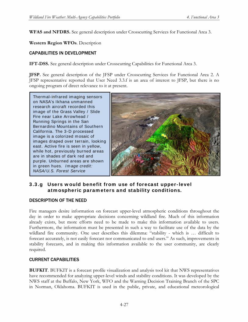
Wildland Fire Weather: Multi-Agency Capabilities Portfolio 4. Functional Area 3
4-27
WFAS and NFDRS. See general description under Crosscutting Services for Functional Area 3. Western Region WFOs. Description
CAPABILITIES IN DEVELOPMENT
IFT-DSS. See general description under Crosscutting Capabilities for Functional Area 3. JFSP. See general description of the JFSP under Crosscutting Services for Functional Area 2. A JFSP representative reported that User Need 3.3.f is an area of interest to JFSP, but there is no ongoing program of direct relevance to it at present.
3.3.g Users would benefit from use of forecast upper-level atmospheric parameters and stability conditions.
DESCRIPTION OF THE NEED
Fire managers desire information on forecast upper-level atmospheric conditions throughout the day in order to make appropriate decisions concerning wildland fire. Much of this information already exists, but more efforts need to be made to make this information available to users. Furthermore, the information must be presented in such a way to facilitate use of the data by the wildland fire community. One user describes this dilemma: “stability - which is … difficult to forecast accurately, is not easily forecast nor communicated to end users.” As such, improvements in stability forecasts, and in making this information available to the user community, are clearly required.
CURRENT CAPABILITIES
BUFKIT. BUFKIT is a forecast profile visualization and analysis tool kit that NWS representatives have recommended for analyzing upper-level winds and stability conditions. It was developed by the NWS staff at the Buffalo, New York, WFO and the Warning Decision Training Branch of the SPC in Norman, Oklahoma. BUFKIT is used in the public, private, and educational meteorological
Thermal-infrared imaging sensors on NASA's Ikhana unmanned research aircraft recorded this image of the Grass Valley / Slide Fire near Lake Arrowhead / Running Springs in the San Bernardino Mountains of Southern California. The 3-D processed image is a colorized mosaic of images draped over terrain, looking east. Active fire is seen in yellow, while hot, previously burned areas are in shades of dark red and purple. Unburned areas are shown in green hues. Image credit: NASA/U.S. Forest Service
Wildland Fire Weather: Multi-Agency Capabilities Portfolio 4. Functional Area 3
4-28
sectors in both the United States and Canada. It is available to anyone who is interested in the analysis of forecast hourly profiles. FCAMMS. See general description under Other Crosscutting Current Capabilities for Functional Area 1. With respect to User Need 3.3.g, FCAMMS is evaluating use of upper air properties for fire business, beyond the Haines Index, while also providing forecasts of the Haines Index itself. DRI-CEFA. See general description under Other Crosscutting Current Capabilities for Functional Area 1. As part of the national Bluesky project, CEFA is providing forecasts of transport winds and Haines indices using output from the NWS NAM and GFS models. NICC/GACC Predictive Services Units. See general description of Predictive Services under Other Crosscutting Current Capabilities for Functional Area 1 and the description of the Predictive Services Program in chapter 1, Introduction. For User Need 3.3.g, Predictive Services meteorologists use NWS forecasts of upper-level parameters and stability conditions but also develop their own analyses and forecasts from observations (NESDIS data in NDFD, etc.). Current NWS Data Streams. See general description under Other Crosscutting Current Capabilities for Functional Area 1. With respect to User Need 3.3.g, NWS/NCEP runs a variety of NWP models capable of producing a variety of forecasts for upper-level atmospheric parameters and stability conditions. Atmospheric stability analysis tools are freely available to forecasters and individuals who have land management responsibilities. The BUFKIT program (see entry above for this User Need) is an excellent analysis tool for upper level winds and stability.
CAPABILITIES IN DEVELOPMENT
National Ventilation Index Value Maps. See general description under Crosscutting Capabilities for Functional Area 2.
CHALLENGES TO MEETING THE NEED
Coordination – Fire users need to provide specific requirements for this type of data Data – Availability of easily accessed, web-based upper air data
3.4 To help all fire weather forecasters meet the increasing needs of wildland fire managers, a more consistent and standardized set of product requirements is needed.
Fire weather forecaster training would be enhanced by more consistent and standardized wildland fire support products and tools being made available and used throughout the community. These tools must emphasize standardized fire weather thresholds which are critical to the wildland fire community. Fire weather forecaster training would be enhanced by more standardized product usage availability throughout the community. This would allow more consistent use of products, reduce confusion, and better ensure that products are optimized for their effectiveness.
Wildland Fire Weather: Multi-Agency Capabilities Portfolio 4. Functional Area 3
4-29
Fire weather forecaster training must include localized considerations for varying regions of the country. This effort would be enhanced by the development of local references, made available online, for fire weather forecasters to train on while at home, and in preparation for deployments.
3.4.a Fire weather forecasters need to develop and support standard representations of fuels information along with standard meteorological conditions and fire weather threats.
DESCRIPTION OF THE NEED
Wildland fire weather users are hindered by non-standard depictions of standard wildland fire weather and fuels data elements. Because many of these elements are common to the entire community, standards are required. Development of these standards would allow users to quickly and correctly interpret conditions and make accurate decisions. Additionally, this would help the community train new fire weather users and allow for improved communication and understanding.
CURRENT CAPABILITIES
NICC/GACC Predictive Services Units. See general description of Predictive Services under Other Crosscutting Current Capabilities for Functional Area 1 and the description of the Predictive Services Program in chapter 1, Introduction. Although Predictive Services products such as the Seven-Day Outlook already include some standardized representation of fuels information, further standardization needs to be developed and is an ongoing activity. There tend to be local or regional de facto standards for fuels information and for interpreting that information into watches, warnings, etc., but practices from one warning area to adjacent ones within same or similar ecosystems are not yet fully consistent and coordinated. NWS Fire Weather Training for WFO & IMET. See general description under Crosscutting Capabilities for Functional Area 3.
CAPABILITIES IN DEVELOPMENT
IFT-DSS. See general description under Crosscutting Capabilities for Functional Area 3.
3.4.b Fire weather forecasters need clear depictions of critical and standardized threshold/breakpoint conditions on their standard product suite of analyses, forecasts, and decision-support tools.
DESCRIPTION OF THE NEED
Wildland fire weather users need clearer depictions of their weather data and fuels thresholds on charts which are produced for their use. Standard representations of these critical thresholds, in a way that accentuates important information, will better inform users to significant events. This improved communication will better assure time-sensitive decisions are made with correct understanding of the current and forecast conditions.
Wildland Fire Weather: Multi-Agency Capabilities Portfolio 4. Functional Area 3
4-30
One user also asked that this information be included along with standard forecast products. In their example, they recommend the wildland fire weather community, “Add the fire weather thresholds in a table above [the product]. Same for fire warnings. Example Current :RH 5% WINDS 21 Gust to 30 Warning threshold: RH: 9% Winds 18 Watch Threshold: RH 11%, possible 9%, Winds 11, possible 18 mph This would give users a quick way of looking at the threshold.” This recommendation highlights a requirement voiced by many members of the community. Standard thresholds are required, and products must clearly display these thresholds and make use of them, to better meet the requirements of the wildland fire community.
CURRENT CAPABILITIES
NICC/GACC Predictive Services Units. See general description of Predictive Services under Other Crosscutting Current Capabilities for Functional Area 1 and the description of the Predictive Services Program in chapter 1, Introduction. Although Predictive Services products already include some standardized criteria on thresholds, further standardization needs to be developed and is an ongoing activity. As with fuels information (User Need 3.3.a), there tend to be local or regional de facto standards for critical thresholds used to make decisions on issuing watches, warnings, etc. However, thresholds practices are not yet fully consistent and coordinated from one warning area to adjacent ones within the same or a similar ecosystem. NWS Fire Weather Training for WFO & IMET. See general description under Crosscutting Capabilities for Functional Area 3.
CAPABILITIES IN DEVELOPMENT
NICC/GACC Predictive Services Units. See general description of Predictive Services under Other Crosscutting Current Capabilities for Functional Area 1 and the description of the Predictive Services Program in chapter 1, Introduction. NWS/USFS Critical Coordination and Threshold. Implicit in the Red Flag Warning criteria are heuristically or statistically derived hypotheses about critical conditions that lead to large fire outbreaks and large fire potential. Science-based evidence is needed to support, explain, and refine these threshold criteria. The NICC Predictive Services unit is also attempting to standardize critical fire potential products, such as the dryness level products and go/no-go fuels information maps in select GACCs.
CHALLENGES TO MEETING THE NEED
Coordination – Provision of critical fuels information is not standardized among GACC’s. Gaps exist in dryness level products and also provision of go/no-go Red Flag decision advice Processes – Resources –
3.4.c The fire community needs to establish accuracy requirements for fire weather products and services to enable the provider community to focus mprovement efforts where most beneficial.
Wildland Fire Weather: Multi-Agency Capabilities Portfolio 4. Functional Area 3
4-31
DESCRIPTION OF THE NEED
Wildland fire weather producers need to know the accuracy requirements of the fire weather user community. Knowledge of these requirements will enable the forecast community to focus efforts where greater accuracy is most important. It further helps forecasters to know if they are achieving their objectives. And, it is crucial so that the user community knows how useful the products are and can effectively evaluate risk management decisions. Emergency managers can make much better decisions when provided with knowledge of expected product accuracy. One user hit the core of this by stating, “How can you operate without accuracy standards.”
CURRENT CAPABILITIES
NWS Fire Weather Training for WFO & IMET. See general description under Crosscutting Capabilities for Functional Area 3. NWS NFDRS Verification Program. See general description under Crosscutting Capabilities for Functional Area 3.
CAPABILITIES IN DEVELOPMENT
NICC/GACC Predictive Services Units. See general description of Predictive Services under Other Crosscutting Current Capabilities for Functional Area 1 and the description of the Predictive Services Program in chapter 1, Introduction. The need for accuracy requirements has been expressed by users of Predictive Services products, but this capability still needs to be developed.
CHALLENGES TO MEETING THE NEED
Coordination – need to define critical weather parameter thresholds with users. Resources – give users access to NWS verification data Processes – develop new verification system using defined thresholds per 3a.

Wildland Fire Weather: Multi-Agency Capabilities Portfolio 5. Functional Area 4
5-1
Chapter 5 Functional Area 4: Modeling, Prediction,
and Data Assimilation
In the context of the NWFWNA, this functional area refers to the numerical tools and data needed to produce fire/atmosphere prediction-related products. It focuses on numerical prediction tools related to fire weather, fire danger, smoke behavior, and/or fire behavior, along with the associated techniques for assimilating data into those tools and displaying the prediction results. The following topics are included in this functional area:
The spectrum of users’ needs and requirements for predictive information
Users’ current modeling platforms, prediction products, data ingestion needs, and data assimilation techniques
Needed capabilities not currently available and knowledge gaps related to providing those capabilities
Existing and potential capabilities in the Federal sector
Potential partnerships that can improve existing predictive products and services or provide new ones to serve unmet user needs
The JAG analysis of user input for this area documents and recommends requirements and capability needs (knowledge gaps) for the wildland fire/atmospheric interface in the following topical areas:
Fire weather data
Real-time fire planning, mitigation, and suppression
Fire danger and behavior
Air quality and smoke behavior
Climate variability implications for fire severity The JAG analysis for this functional area defined general research knowledge gaps, identified areas of likely research partnerships, and addressed general guidance on the time and resources that will be needed to fill these gaps. These results are formulated as one major need with four subneeds.
4.1 Fire weather users and the meteorological community require the rapid transfer of fine-scale modeling, coupled fire-atmosphere modeling, and climate modeling advances into operations; emphasizing capabilities, limitations, and current improvement efforts.
Users indicated that the following model output products are very important: wind speed, wind direction, relative humidity, fuel moisture, precipitation (duration and amount), smoke trajectories,
Wildland Fire Weather: Multi-Agency Capabilities Portfolio 5. Functional Area 4
5-2
fire spread, surface air temperature, inversion/stagnation conditions, mountain wind patterns, Haines index, fire danger, fire intensity, mixing height, lapse rate, and ground level smoke density/ pollutant concentration. Users indicated that the following model output products are moderately important: upper air winds, transition to crown fire, cloud cover percentage, fuel temperature, and soil moisture.
Users were especially concerned with the lack of forecast information and accuracy concerning: transition to crown fire, mountain wind patterns, ground-level smoke density/pollutant concentration, lapse rate, inversion/stagnation conditions, fire intensity, mixing height, smoke trajectories, and fire spread.
4.1.a Users overwhelmingly need higher resolution meteorological model fields in complex terrain and the tools and input data to understand fire behavior and smoke dispersion.
DESCRIPTION OF THE NEED
Users urgently require more frequent, dense, and accurate wind forecasts, with special emphasis on mountain winds, where the data are of low quality, insufficient, or (in many comments) not available at all. (Some users said they had no source for mountain winds.) The resolution requested was split, but weighted heavily towards finer spatial resolution—considerably finer than is currently run routinely in real time anywhere. Users unanimously desire and require more and better quality model data on the three fire behavior fields (fire spread, fire intensity, and transition to crown fire). This need reflects the fact that forecast results for these fields are currently either not routinely provided or not uniformly provided (in contrast, to routine, uniform reports of observation data and forecasts for weather elements). Interpretation of specific needs for these fire behavior fields should consider the following caveats:
Because these fields are not provided routinely or uniformly, no consensus has been developed.
A variety of usage scenarios is apparent: information for short term, tactical uses (within the day), information for planning the next few days, and strategic planning for the next week or beyond.
Users were asked about the importance of several model output variables. As a result, they indicated a critical need for those fields pertaining to wind (wind speed, wind direction, and mountain wind patterns), fire behavior (fire intensity, fire spread, and transition to crown fire), atmospheric moisture (relative humidity) and smoke (smoke trajectories and ground level smoke). And, users typically indicated that almost all of this information was used primary to better understand and anticipate fire behavior. Users clearly stated a requirement for more and better wind forecasts, with special emphasis on mountain winds, where data are especially of low quality or insufficient (if available at all). Users tended to ask for finer resolutions, on the order of 1 km, reflecting a desire for a spatial resolution which is finer than that routinely available in real-time from any source.
Wildland Fire Weather: Multi-Agency Capabilities Portfolio 5. Functional Area 4
5-3
Although the importance was rated very high, users were unanimous in not having sufficient access to high quality model data on the three fire behavior fields. This reflects the fact that forecast output for these fields is not currently provided either routinely or uniformly (in contrast to weather data and forecasts). Interpretations of specific requirements for these fire behavior fields should consider that: (1) because these fields are not provided routinely or uniformly, no consensus has been developed, (2) a variety of usage scenarios is apparent – information for short term, tactical uses (within the day), information for planning the next few days, and strategic planning for the next week or beyond. Users require relative humidity information and forecasts updated more frequently. Users are generally disappointed with the information they receive on smoke products, nearly unanimously saying they did not receive enough of it nor was it of sufficient quality, while some said they had no source. The spatial resolution requested was weighted towards finer spatial resolution, finer than is currently simulated routinely by either air quality models or the underlying meteorological models. Another area in which many users indicated important work was needed was related to atmospheric stability (lapse rates, inversions, and stagnation conditions). The vast majority stated that this information is needed for their operations, but many are not satisfied with the quality or the sufficiency of the data. Additionally, there must be a greater focus on more multidisciplinary computer models to improve our ability to simulate the interrelations of fuels, fire, and weather. Furthermore, this should be expanded to include greater simulations of socioeconomic impacts of fires, should they develop, based upon the potential threat to various areas. This effort should also include better modeling of the affects of land management practices to allow for greater understanding of which practices are most effective, in terms of land management, and in terms of socioeconomic protection of life, property, and natural resources.
CURRENT CAPABILITIES
DRI-CEFA. See general description under Other Crosscutting Current Capabilities for Functional Area 1. CEFA currently runs the MM5 mesoscale NWP model at a 4 km resolution across California and Nevada for input into the Bluesky smoke framework, as well as for output of basic fire weather fields (e.g., wind, relative humidity, temperature). This system is scheduled to be updated in 2009 to use the WRF model and a 2 km forecast resolution. FARSITE. See general description under Crosscutting Capabilities for Functional Area 3. FCAMMS. See general description under Other Crosscutting Current Capabilities for Functional Area 1. Past and ongoing FCAMMS work has included investigating the effect of increased model resolution on calculation of fire indices and smoke dispersion. Modeling of fine-scale winds in complex terrain is an inherent component of FCAMMS local smoke modeling tools, the PB models, and the thunderstorm outflow modeling efforts. These models are capable of producing surface wind fields with resolutions of less than 100 meters. Work is continuing on development of a sub-kilometer scale nonhydrostatic spectral model for simulations of up to 48 hours.
Wildland Fire Weather: Multi-Agency Capabilities Portfolio 5. Functional Area 4
5-4
JFSP. See general description of JFSP under Crosscutting Capabilities for Functional Area 2. Of particular relevance to User Need 4.1.a is a JFSP-funded study on Fuel Consumption and Flammability Thresholds in Shrub-Dominated Ecosystems. Research to quantify fuel consumption and flammability in shrub-dominated ecosystems has received little attention despite the widespread occurrence of fire-influenced, shrub-dominated landscapes across the arid lands of the western United States. While some research has addressed issues relating to fire behavior in some shrub-dominated ecosystems, quantification of fuel consumption is critical for effective modeling of fire effects (e.g., smoke emissions, regional haze, erosion, plant succession, etc.) and landscape management. Preliminary research in this arena has generated hypotheses as to the controlling mechanisms for fuel consumption in shrub fuel types that require testing through field-based experimentation. The primary objective of this JFSP-supported research was to improve existing fuel consumption models for sagebrush fuel types and to develop new models for additional shrub-dominated fuel types for incorporation into a module for, or a new version of, the software package CONSUME. The research addressed issues related to seasonal live fuel moisture and weather patterns and their relations to flammability in shrub-dominated fuel types. Making fuel and fire management decision support tools such as CONSUME more robust will aid managers, planners and researchers in developing environmentally, socially, and legally responsible land management plans. This research allows for more effective and informed use of fire behavior, fire effects, emission production, and wildfire/prescribed fire trade-off models, providing for better wildland fire emissions and fire effects accounting and planning at local, regional, national and global scales. NCAR. See general description of NCAR under Crosscutting Capabilities for Functional Area 2 and the entry under User Need 2.1.a. The Mesoscale and Microscale Meteorology Division conducts research, development, and application of atmosphere-fire models coupled with WRF-derived models. These coupled atmosphere-fire models have been demonstrated in an operational configuration. The NCAR Research Applications Laboratory has been investigating fine-scale modeling in real time. NEXRAD Weather Radar Network. See general description under Other Crosscutting Current Capabilities for Functional Area 1. NICC/GACC Predictive Services Units. See general description of Predictive Services under Other Crosscutting Current Capabilities for Functional Area 1 and the description of the Predictive Services Program in chapter 1, Introduction. Resolutions in the meteorological models for complex terrain continue to improve with implementation of operational WRF-based models and other mesoscale modeling capabilities. This is an area of ongoing continual improvement, as misoscale resolution is highly desirable in some terrains. NSF-funded study of Data Dynamic Simulation for Disaster Management. See description of this NSF-funded project under the NSF general description, in Crosscutting Capabilities for Functional Area 2. NWS Environmental Modeling Center. See general description under Crosscutting Services for Functional Area 3. As of fall 2007, the NWS/EMC was working on improvements to smoke models that would contribute to meeting User Need 4.1.a.
Wildland Fire Weather: Multi-Agency Capabilities Portfolio 5. Functional Area 4
5-5
NWS WFO Fire Weather Product and Services. See general description under Crosscutting Capabilities for Functional Area 2 and the description of Internet-disseminated digital data for fire weather users under User Need 3.3.f. RMRS Fire, Fuel and Smoke Program. See general description of the Forest Service RMRS under Crosscutting Capabilities for Functional Area 2. WRAP. See general description under Crosscutting Capabilities in Development for Functional Area 1.
CAPABILITIES IN DEVELOPMENT
IEOS planned capability. See general description under Crosscutting Capabilities in Development for Functional Area 1. JFSP. See general description of JFSP under Crosscutting Capabilities for Functional Area 2. An ongoing development effort is to improve models for integration in a fuels treatment software integration framework. MPAR Network. See general description under Crosscutting Capabilities in Development for Functional Area 1. Nationwide Network of Observing Mesonets. See general description under Crosscutting Capabilities in Development for Functional Area 1. Satellite-based Observing Systems. See Capabilities in Development for User Need 2.1.b for a description of the satellite-based FRP (fire radiative power) parameter and its use as an input to smoke models. Weather Pod Remote Met Sensor. See general description under Crosscutting Capabilities in Development for Functional Area 1. WRF-Chem Model. See general description under Crosscutting Capabilities for Functional Area 2.
CHALLENGES TO MEETING THE NEED
[TBA: The challenges that must be addressed]
4.1.b Users need model accuracy and confidence information presented to them in an understandable format.
DESCRIPTION OF THE NEED
Users must understand that accurate-looking products are not necessarily as accurate as they appear and they can have significant error ranges. Model products need to include this information to aid the wildland fire community in using the products appropriately. The requirement for information on model accuracy and confidence (in the statistical sense of confidence limits) extends to coarse
Wildland Fire Weather: Multi-Agency Capabilities Portfolio 5. Functional Area 4
5-6
models, fine-scale models, coupled models, and climate models. The use of confidence levels is vital to afford decision makers with actionable intelligence on the likelihood of various scenarios. This information is integral to meaningful risk management decisions and allows the users to better understand how environmental conditions could impact their decisions. This requirement that this additional information be made available will only increase as finer-resolution model output data are made available. As described by one user, “By knowing their [the forecaster’s] level of confidence, we can then estimate with better confidence what types of fire activities we can expect.” And, another user, when described forecast text products stated, “The narrative should clearly address the confidence level and bias of the forecast.” Each of these comments indicates a similar requirement for accuracy and confidence information. Note that the fields most urgently required (wind speed and direction and relative humidity) are among the fields with the highest prediction errors according to routine verification procedures for real-time mesoscale modeling. Current verification statistics do not show the predictions for these fields improving with increased model resolution, given the present state of model parameterizations. Nonetheless, improvements are expected as better models are developed.
CURRENT CAPABILITIES
FARSITE. See general description under Crosscutting Capabilities for Functional Area 3. NICC/GACC Predictive Services Units. See general description of Predictive Services under Other Crosscutting Current Capabilities for Functional Area 1 and the description of the Predictive Services Program in chapter 1, Introduction. The DRI website includes some user-friendly information on model accuracy and confidence limits for Predictive Services products. DRI also provides verification data for the NWS GFS model as an input to Predictive Services products. More work is needed on providing forecast confidence information that is meaningful and useful to the user community beyond meteorologists. RMRS Fire, Fuel and Smoke Program. See general description of the Forest Service RMRS under Crosscutting Capabilities for Functional Area 2.
CAPABILITIES IN DEVELOPMENT
JFSP See general description of JFSP under Crosscutting Capabilities for Functional Area 2. Of particular relevance to User Need 4.1.b is the JFSP-funded Smoke and Emissions Model Intercomparison Project. This is a multiyear community effort to analyze fire consumption, fire emissions, plume rise, and smoke dispersion models. The activity is designed to be an open, collaborative project. NSF-funded study of Data Dynamic Simulation for Disaster Management. See description of this NSF-funded project under the NSF general description, in Crosscutting Capabilities for Functional Area 2. SDSMT Curriculum in Wildfire Management. See general description under Crosscutting Capabilities for Functional Area 2.
Wildland Fire Weather: Multi-Agency Capabilities Portfolio 5. Functional Area 4
5-7
CHALLENGES TO MEETING THE NEED
[TBA: The challenges that must be addressed]
4.1.c The fire community needs better modeling of fire potential, threat, and impacts associated with climate and climate change.
DESCRIPTION OF THE NEED
Users are aware that climate change is impacting their ability to prepare for and mitigate destructive wildland fires. However, there is much uncertainty concerning how climate change will affect various regions of the country and what should be done to prepare appropriately for future changes. Improved modeling of climate change scenarios is required and will enable wildland fire weather users to better understand potential climate impacts so they can manage and monitor wildland ecology, thereby reducing damaging wildland fires.
CURRENT CAPABILITIES
FARSITE. See general description under Crosscutting Capabilities for Functional Area 3. NICC/GACC Predictive Services Units. See general description of Predictive Services under Other Crosscutting Current Capabilities for Functional Area 1 and the description of the Predictive Services Program in chapter 1, Introduction. Whereas modeling capabilities exist for current fire potential, threat, and impacts, there is only limited capability to model these parameters at the climate trend level (seasonal to interannual). DRI has done some fire potential modeling using climate models. RMRS Fire, Fuel and Smoke Program. See general description of the Forest Service RMRS under Crosscutting Capabilities for Functional Area 2.
CAPABILITIES IN DEVELOPMENT
FCAMMS. See general description under Other Crosscutting Current Capabilities for Functional Area 1. Ongoing work on future Haines Index scenarios and quantifying patterns such as ENSO and PNA in ways that best reflect fire activity. Regional climate modeling studies are just beginning to address various climate change scenarios and will provide foundational knowledge in this area. IFT-DSS. See general description under Crosscutting Capabilities for Functional Area 3. NSF Research Grant: Fire Is an Important and Under-Appreciated Part of Global Climate Change. See general description of NSF under Crosscutting Capabilities for Functional Area 2. The premise of this project is that wildland fire must be accounted for as an integral part of climate change. Intentional deforestation fires alone contribute up to one-fifth of the human-caused increase in emissions of carbon dioxide, a heat-trapping gas that increases global temperature. Carbon dioxide is the most important and well-studied greenhouse gas that is emitted by burning plants. However, methane, aerosol particulates in smoke, and the changing reflectance of a charred landscape each contribute to changes in the atmosphere caused by fire. Consequences of large fires
Wildland Fire Weather: Multi-Agency Capabilities Portfolio 5. Functional Area 4
5-8
have huge economic, environmental, and health costs. Earth is intrinsically a flammable planet due to its cover of carbon-rich vegetation, seasonally dry climates, atmospheric oxygen, widespread lightning and volcano ignitions. Yet, despite the human species' long-held appreciation of this flammability, the global scope of fire has been revealed only recently by satellite observations available beginning in the 1980s. NSF Research Grant: Petascale Computer Modeling. See general description of NSF under Crosscutting Capabilities for Functional Area 2. This project is investigating the potential for a new generation of computer models (petascale models performing 1015 calculations per second) to depict detailed climate dynamics. Researchers at the University of Miami Rosenstiel School of Marine and Atmospheric Science, NCAR, the Center for Ocean-Land-Atmospheric Studies in Calverton, Md., and the University of California at Berkeley are using a $1.4 million award from NSF to generate the new models. According to this research team, although true petascale processing remains rare, it offers an opportunity for climate scientists to advance Earth system science and help to improve quality of life on the planet. With this boost in computing capabilities, one team member has developed a weather and climate modeling strategy using interactive ensembles to isolate the interactions between weather and climate. These interactive ensembles for weather and climate will be applied to NCAR's Community Climate System Model (CCSM), the current operational model used by NOAA's climate forecast system (CFS). The CCSM is also used by hundreds of researchers and is one of the climate models used for the assessments conducted by the International Panel on Climate Change. This project in intended as a pilot program to prepare for the implementation of more intense computational systems, which currently remain a scientific and engineering challenge. NSF Research Grant: Pilot Climate Process and Modeling Teams. See general description of NSF under Crosscutting Capabilities for Functional Area 2. The objective of this project is to speed development of global coupled climate models and reduce uncertainties in climate models by bringing together theoreticians, field observation specialists, process modelers, and the large modeling centers to concentrate on the scientific problems facing climate models today.
CHALLENGES TO MEETING THE NEED
[TBA: The challenges that must be addressed]
4.1.d Model output information needs to be made available in easy-to-use graphics and in high-bandwidth and low-bandwidth formats for use on workstations, PDAs, and via text messaging. Products also need to be available in GIS format.
DESCRIPTION OF THE NEED
The wildland fire weather community is adept at using the output from various numerical models to meet their requirements. However, while many users have ready access to high-bandwidth products and services, others are severely limited in their data access points. All weather products and services production and provider centers must consider the wide range of users and develop products that are well suited for a wide range of customers.
Wildland Fire Weather: Multi-Agency Capabilities Portfolio 5. Functional Area 4
5-9
Many users asked that all graphics be made available in GIS formats. They are familiar with this format, and it allows them to overlay fire weather information easily on geographic maps of other significant data fields. Additionally, many users asked that operational data be made available in a low-bandwidth option, to include text and PDA-viewable graphics. These low-bandwidth formats are especially important for products that are valid only for the near term, such as time-critical information needed to manage existing wildland fires or to warn users of fire threat within the next 24 hours.
CURRENT CAPABILITIES
FARSITE. See general description under Crosscutting Capabilities for Functional Area 3. FCAMMS. See general description under Other Crosscutting Current Services for Functional Area 1. FCAMMS is providing products in a variety of formats including site specific text forecasts for smoke management, GIS layers and maps, and integration of smoke concentration forecasts into Google Earth/Google maps. NSF Research Grant: Data Dynamic Simulation for Disaster Management. See general descriptions of NSF research grants and this individual grant under Crosscutting Capabilities for Functional Area 2. RMRS Fire, Fuel and Smoke Program. See general description of the Forest Service RMRS under Crosscutting Capabilities for Functional Area 2.
CAPABILITIES IN DEVELOPMENT
Interagency RAWS Network and ROMAN. See general description of the RAWS network and the ROMAN data network under Crosscutting Capabilities for Functional Area 1. The RAWS/ROMAN Study Report by FENWT is of particular relevance to User Need 4.1.d. IFT-DSS. See general description under Crosscutting Capabilities for Functional Area 3. NICC/GACC Predictive Services Units. See general description of Predictive Services under Other Crosscutting Current Capabilities for Functional Area 1 and the description of the Predictive Services Program in chapter 1, Introduction. Predictive Services has developed user-oriented graphical interfaces for many of its products and services that convey model output information. Model output is available in high-bandwidth products disseminated in electronic formats from standard Internet webpages and Internet-accessible databases. However, work on low-band formats is just beginning.

Wildland Fire Weather: Multi-Agency Capabilities Portfolio 6. Functional Area 5
6-1
Chapter 6 Functional Area 5: Information Dissemination
and Technologies
This functional area documents and defines requirements and standards for the dissemination of information and related technologies necessary to support sound fire management decisions. A particular focus of this functional area is the processes required to transition current and future technologies to operational status in a timely and organized manner. Another focus is on identifying opportunities for improving collaboration on developing technologies for information dissemination. The following topics fall within the scope of this functional area:
Information dissemination elements required or desired by users
Information dissemination technologies currently used by respondents to support fire weather activities, and identification of which technologies among these are operational i.e., approved/accepted as a basis for official/formal decisions, results, etc.)
Within a respondent’s organization, who uses each of the current technologies and why they need it
Opportunities for improving information dissemination and the development of information dissemination technologies
Experimental (“trial”) technologies being tested or in use by the respondent’s organization and how such experimental technologies are transitioned into routine operations (formal “operational” acceptance)
Opportunities for increased coordination and collaboration (e.g., partnerships within and across Federal, state, local, academic, and commercial sectors) to improve information dissemination, including but not limited to technology development
As in Functional Area 3 for products and services, the functional area for information dissemination and technologies received a great deal of detailed input from the user community. The JAG has defined five major needs based on that input. The JAG judged two of these to be urgent: an Internet presence that provides “one-stop shopping” to facilitate access to products and tools by fire weather uses (Need 5.1) and the related need for robust, real-time access to weather data (Need 5.5).
5.1 A coordinated, “one-stop” fire weather Internet presence is needed to facilitate fire weather user access to pertinent weather data and products for their region of interest.
DESCRIPTION OF THE NEED
The fire weather users urgently must be able to go to a single location for authoritative and comprehensive access to products and services. Users urgently require a site with the following features:
Wildland Fire Weather: Multi-Agency Capabilities Portfolio 6. Functional Area 5
6-2
Allows users to easily locate products and services they need to do their jobs
Includes operational products along with new research, developmental products, and other operational and non-operational tools
Serves as an authorization/certification of various products and services (products available on the site are marked as either certified for use or for evaluation purposes only)
Includes information on product accuracy (this feature could be further enhanced by including information on forecast confidence levels)
Serves as a repository for regional and local information for newcomers and for initial training
Helps simplify training efforts through greater product standardization and access standardization
Includes usage metrics to identify high-use products and/or document increased need for certain products
Provides connections to archived data (e.g.., hyperlinks to data storage sites)
Offers multiple security levels to control access to data
Enables leveraging of existing backup capabilities for data and systems and provides load balancing techniques to help ensure continuous (24-hour) data availability
A key point is that this central Internet presence is meant to serve as an easy-to-use gateway to any and all weather data, research, and materials applicable to the community. However, users still strongly desire use of regionally tailored web sites, to facilitate their daily operations. Given the vast amount of available data and products, tailored web sites still fill a crucial need for regional users to quickly obtain operational data for their routine use.
This central Internet presence is meant to provide ready access to all products, services, references, and news information needed by the fire management community and should be a source they routinely check to ensure they are making the most of all the latest information and material. As expressed by many users, and accurately stated by one user, “I am sure that a one-stop-shopping website would be useful.” And, just to further emphasize the widespread requirement for this, another user stated, “It would be great to have a one-stop-shopping web site!!!!!!” One benefit of this approach is that it would make the community more aware of the growing number of digital weather databases which are available to the community. These provide a wealth of information, in a format which can be readily tailored for decision-support applications. However, without the wide-scale publicity which can be provided via a single Internet site, many users are unaware of these products or their uses. Additionally, once users become accustomed to using these types of products, they need a mechanism which allows them to learn of changes and improvements. Again, a single Internet presence can more readily allow for this type of information flow to the entire community.
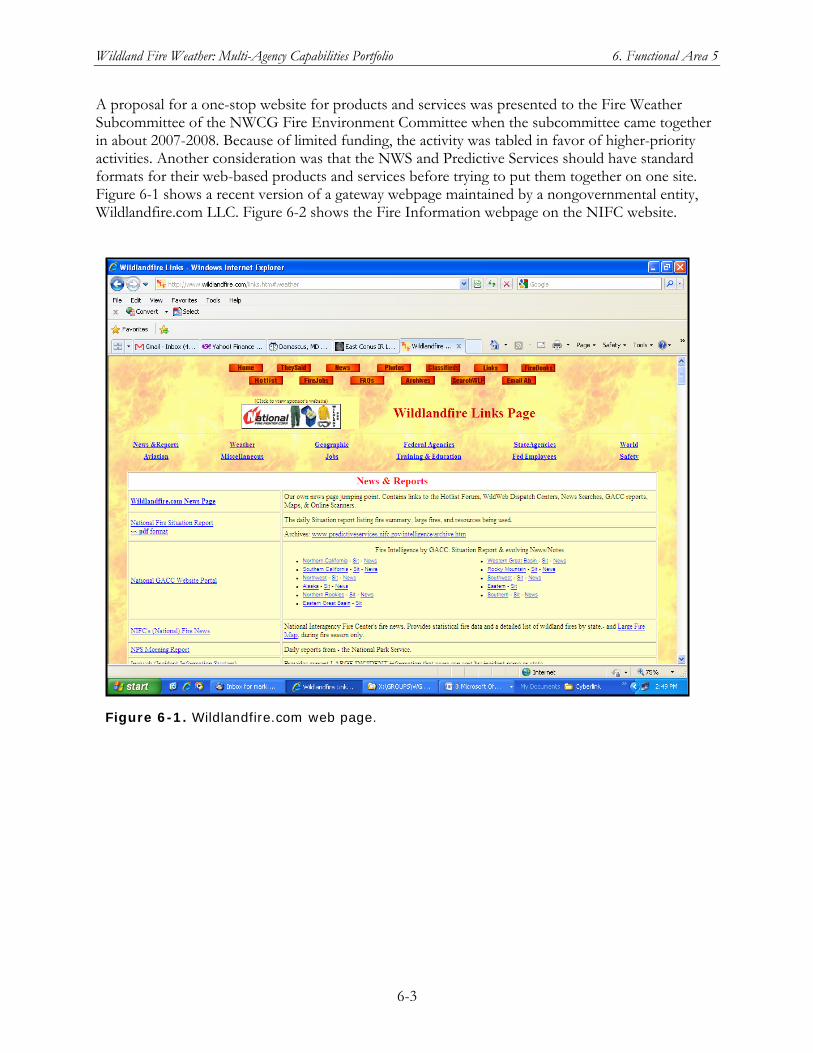
Wildland Fire Weather: Multi-Agency Capabilities Portfolio 6. Functional Area 5
6-3
A proposal for a one-stop website for products and services was presented to the Fire Weather Subcommittee of the NWCG Fire Environment Committee when the subcommittee came together in about 2007-2008. Because of limited funding, the activity was tabled in favor of higher-priority activities. Another consideration was that the NWS and Predictive Services should have standard formats for their web-based products and services before trying to put them together on one site. Figure 6-1 shows a recent version of a gateway webpage maintained by a nongovernmental entity, Wildlandfire.com LLC. Figure 6-2 shows the Fire Information webpage on the NIFC website.
Figure 6-1. Wildlandfire.com web page.
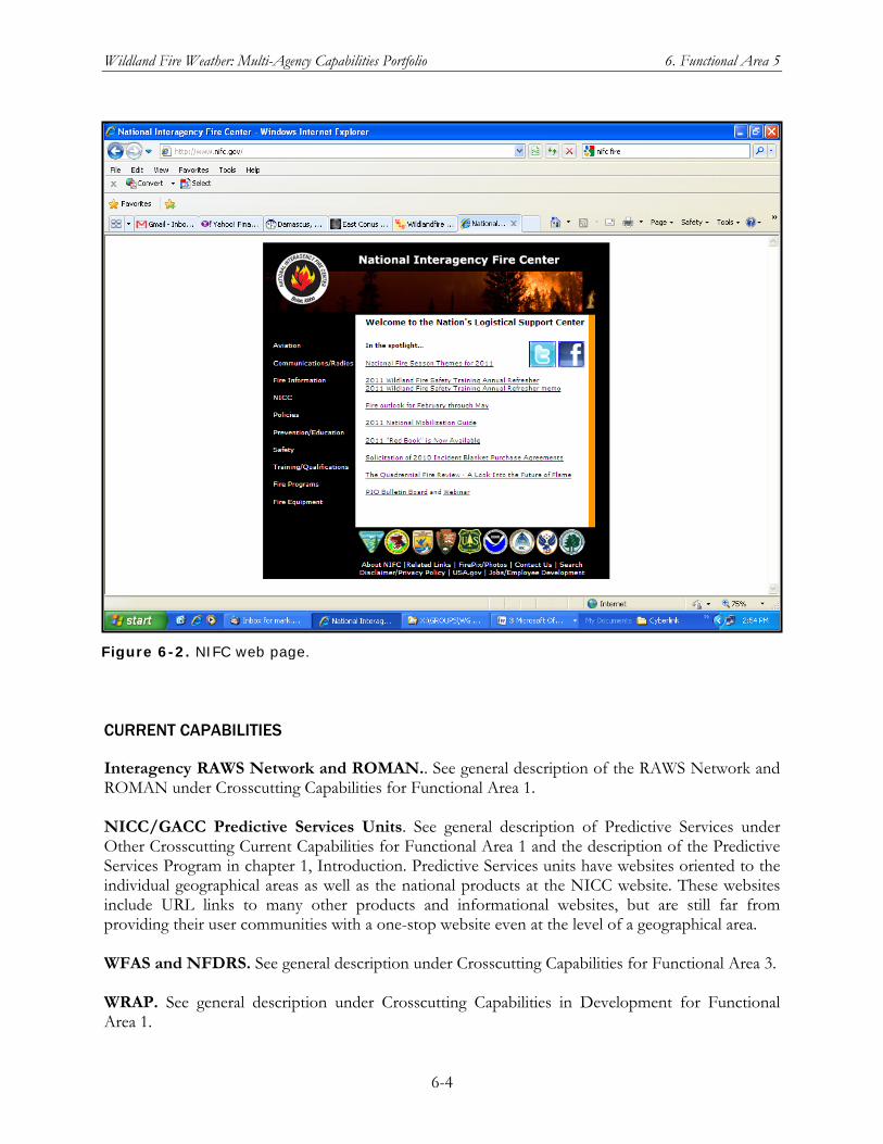
Wildland Fire Weather: Multi-Agency Capabilities Portfolio 6. Functional Area 5
6-4
CURRENT CAPABILITIES
Interagency RAWS Network and ROMAN.. See general description of the RAWS Network and ROMAN under Crosscutting Capabilities for Functional Area 1. NICC/GACC Predictive Services Units. See general description of Predictive Services under Other Crosscutting Current Capabilities for Functional Area 1 and the description of the Predictive Services Program in chapter 1, Introduction. Predictive Services units have websites oriented to the individual geographical areas as well as the national products at the NICC website. These websites include URL links to many other products and informational websites, but are still far from providing their user communities with a one-stop website even at the level of a geographical area. WFAS and NFDRS. See general description under Crosscutting Capabilities for Functional Area 3. WRAP. See general description under Crosscutting Capabilities in Development for Functional Area 1.
Figure 6-2. NIFC web page.
Wildland Fire Weather: Multi-Agency Capabilities Portfolio 6. Functional Area 5
6-5
CAPABILITIES IN DEVELOPMENT
JFSP. See general description of JFSP under Crosscutting Capabilities for Functional Area 2. A JFSP representative acknowledged that work is needed to integrate outputs from models developed under JFSP with the following major fire management and planning systems:
IFT-DSS. See general description under Crosscutting Capabilities in Development for Functional Area 3.
BlueSky. This modeling framework is a leading example of modularizing and connecting scientific models. JFSP sees it as a likely candidate for creation of a web-based, collaborative architecture system
WFDSS. See general description under Crosscutting Capabilities for Functional Area 3.
5.2 A centralized means for collaboration on products and services is needed.
DESCRIPTION OF THE NEED
Users require a mechanism to allow feedback to product developers for future product improvement efforts. This mechanism would allow developers to understand how users are attempting to use their products and how their products are currently performing. Feedback would allow developers to be more responsive to the needs of the community. An accessible means of providing feedback would encourage the community to provide this vital information to developers, resulting in essential product improvements.
CURRENT CAPABILITIES
Interagency RAWS Network, ASCADS, and Downstream Applications of RAWS Data. See general description under Crosscutting Capabilities for Functional Area 1. NICC/GACC Predictive Services Units. See general description of Predictive Services under Other Crosscutting Current Capabilities for Functional Area 1 and the description of the Predictive Services Program in chapter 1, Introduction. Predictive Services representatives believe that this user need can be met through the NWCG Fire Environment Committee and its subcommittees, particularly the Fire Weather Subcommittee and the National Predictive Services Subcommittee. NWS participation on these subcommittees has been strong since the streamlining of the coordination structure under the NWCG. RMRS Fire, Fuel and Smoke Program. See general description of the Forest Service RMRS under Crosscutting Capabilities for Functional Area 2. National Science Foundation (Data Dynamic Simulation for Disaster Management). The grant enables a team to create a system where multiple sensors placed around a wildfire will continuously send inputs, such as temperature, wind direction and speed, and the moisture in grass and sticks, to a high-end research computer for analysis.
Wildland Fire Weather: Multi-Agency Capabilities Portfolio 6. Functional Area 5
6-6
CAPABILITIES IN DEVELOPMENT
IFT-DSS. See general description under Crosscutting Capabilities for Functional Area 3. NSF Research Grant: Data Dynamic Simulation for Disaster Management. See general descriptions of NSF research grants and this individual grant under Crosscutting Capabilities for Functional Area 2.
5.3 Consistent dissemination of timely products and services to model users is needed.
DESCRIPTION OF THE NEED
There are many operational services and products that leverage available model data to make decision aids for the community. All of these services require consistent, robust data flow to ensure that users are provided with timely and meaning products and decision aids. As a point of interest, many users are particularly pleased with ROMAN and most stated that it is an excellent source of data. Other systems that also received high marks were FX-NET and FireFamily Plus. All of these tools make use of data available through other sources and they are reliant upon rapid, robust dissemination of these data. Furthermore, the community is reliant on robust data sharing among the community to ensure all data are made available as quickly as possible, and with continuity of operations planning to ensure that outages are minimal.
CURRENT CAPABILITIES
Interagency RAWS Network and ROMAN. See general description under Crosscutting Capabilities for Functional Area 1. NICC/GACC Predictive Services Units. See general description of Predictive Services under Other Crosscutting Current Capabilities for Functional Area 1 and the description of the Predictive Services Program in chapter 1, Introduction. Predictive Services is both a user of many kinds of models and a provider of products and services to other model users. The Predictive Services representatives see the NWS as being further along in meeting this need fully, while Predictive Services is still working on providing model data that are available within user’s decision time constraints. RMRS Fire, Fuel and Smoke Program. See general description of the Forest Service RMRS under Crosscutting Capabilities for Functional Area 2. WFAS and NFDRS. See general description under Crosscutting Capabilities for Functional Area 3. NWS WFO Fire Weather Products and Services. See the general description of WFO Fire Weather Products and Services under Crosscutting Capabilities for Functional Area 3 and the description of digital data customized for fire weather users under Current Capabilities for User Need 3.3.f
Wildland Fire Weather: Multi-Agency Capabilities Portfolio 6. Functional Area 5
6-7
CAPABILITIES IN DEVELOPMENT
MPAR Network. See general description under Crosscutting Capabilities in Development for Functional Area 1. NSF Research Grant: Data Dynamic Simulation for Disaster Management. See general descriptions of NSF research grants and this individual grant under Crosscutting Capabilities for Functional Area 2. WFDSS. See general description under Crosscutting Capabilities for Functional Area 3.
5.4 More products need to be available in low bandwidth formats for users using telephones and/or PDAs to receive the data.
DESCRIPTION OF THE NEED
As described in Section 4.1.d, many users have limited access to fire weather products, especially when dealing with active wildland fires. Products intended to inform users of near-term threats or changing conditions must be made available to a wide variety of low-bandwidth users. Greater use of text information and PDA-viewable formats (figure 6-3) would vastly improve operational weather support to these sectors within the wildland fire community.
CURRENT CAPABILITIES
NWS Web Services via Wireless Technologies. Since February 2008, NOAA/NWS has been providing selected NWS warning, forecast, and observational text products in presentation formats suitable for smaller screens of portable devises that use any language (display protocol) compatible with the Wireless Access Protocol (WAP), an industry standard based on encoding in an Extensible Markup Language (XML) format.
A menu of current wireless-accessible products can be accessed at http://mobile.srh.noaa.gov/
The NWS Mobile access page is http://mobile.wrh.noaa.gov/wml/index.php Entering a Zip code or City and State gives current local observation and point forecast data.
Although fire weather is not an option currently available from these access points, they represent an existing communications channel that could be used for fire weather content.
CAPABILITIES IN DEVELOPMENT
NICC/GACC Predictive Services Units. See general description of Predictive Services under Other Crosscutting Current Capabilities for Functional Area 1 and the description of the Predictive Services Program in chapter 1, Introduction. See the comments for Predictive Services in response to User Need 4.1.d.
Wildland Fire Weather: Multi-Agency Capabilities Portfolio 6. Functional Area 5
6-8
5.5 Wildland fire weather users and providers require robust, real-time access to weather data, to include increased continuity of operations planning.
Wildland fire weather users make time-critical decisions based upon the latest wildland fire weather products and services. Their ability to make accurate, time-critical decisions is affected by the timeliness and availability of these products and services. Given the relentless cycle of wildland fires in recent years, it has become increasingly crucial that wildland fire weather data always be available, with robust backups tested and in place, to ensure that users have the information they need to increase their ability to protect lives and property threatened by wildland fires.
5.5.a Wildland fire weather users require a robust continuity of operations plan for the Geostationary Operational Environmental Satellite (GOES) Data Collection System (DCS), which serves as an integral mechanism for this flow of data.
DESCRIPTION OF THE NEED
GOES-DCS is a signal relay system used to collect radio signals from Earth-based platforms and then transmit the data, again via radio signal, to a receiving station on Earth. In the case of data collection from RAWS units, the collected radio signals contain the environmental observations made the sensors on the RAWS. Signals are transmitted from the RAWS at preset wavelengths and times. The transponder on the receiving GOES satellite detects this signal and rebroadcasts it for pickup at the control and data station on Wallops Island, Virginia. Any ground-based receiving equipment with the correct configuration can also receive the rebroadcast signal. With GOES-DCS to collect data in a timely way (multiple times per day) from RAWS units, initial installation and regular maintenance are usually the only operations that require personnel to visit the installation site. Automated data collection via satellite enables more frequent and more geographically complete environmental monitoring than most agencies could otherwise fund. In situ RAWS units provide access to a different set of observational parameters than can be currently observed using remote-sensing systems such as satellite-based radiometers. An in situ system also provides critical ground truth for remote-sensing systems. The DCS Automated Processing System, or DAPS, further automates the processing and dissemination of RAWS data after it is received at the Wallops Island ground station. DAPS can be used to download collected data and to update a Platform Description Table (PDT) or other database records. The RAWS data provided by GOES DCS provide critical support to the wildland fire community. Therefore, a robust backup capability is essential. However, because GOES-DCS is not currently classified as an important operational system within NOAA’s National Environmental Satellite, Data, and Information Service (NESDIS), it does not have a robust backup. This is an urgent requirement. As of October 2009, Predictive Services representatives confirmed that this remains an important need but did not know whether any progress had been made on a plan for continuity of operations.
Wildland Fire Weather: Multi-Agency Capabilities Portfolio 6. Functional Area 5
6-9
CURRENT CAPABILITIES
There is currently no backup capability for GOES-DCS
CAPABILITIES IN DEVELOPMENT
IEOS planned capability. See general description under Crosscutting Capabilities in Development for Functional Area 1. Capability to retrieve ground sensor mesonet data from across the United States and globally will be required to meet long-term IEOS and GEOSS goals. Presumably, backup capability for satellite relay of remote-station observation data will be incorporated in an operational system that meets IEOS/GEOSS goals. Nevertheless, a GOES-DCS backup capability is an urgent need now for the wildland fire community in the United States, requiring an interim solution before long-term IEOS capabilities are in place.
5.5.b Wildland fire weather users require a robust continuity of operations plan for the Automated Sorting, Conversion, and Distribution System (ASCADS), which serves as a crucial node for weather data flow.
DESCRIPTION OF THE NEED
See general description of ASCADS under user Need 1.1.b. ASCADS is a potential single point of failure for vital fire weather observational data. A robust backup capability is required to ensure fire weather users have uninterrupted data for their operational use. This is an urgent requirement. As of October 2009, ASCADS was being refreshed and moved under BLM’s Wildland Fire Management Information (WFMI) system. Given this change in ASCADS, the Fire Weather Subcommittee of NWCG’s Fire Environment Committee postponed a proposal to provide a backup capability for ASCADS until FY 2010.
CURRENT CAPABILITIES
Interagency RAWS Network, ASCADS, and Downstream Applications of RAWS Data. See general description under Crosscutting Capabilities for Functional Area 1. RSFWSU for RAWS. See general description under Crosscutting Capabilities for Functional Area 1.
CAPABILITIES IN DEVELOPMENT
IEOS planned capability. See general description under Crosscutting Capabilities in Development for Functional Area 1. MPAR Network. See general description under Crosscutting Capabilities in Development for Functional Area 1. NICC/GACC Predictive Services Units. See general description of Predictive Services under Other Crosscutting Current Capabilities for Functional Area 1 and the description of the Predictive
Wildland Fire Weather: Multi-Agency Capabilities Portfolio 6. Functional Area 5
6-10
Services Program in chapter 1, Introduction. Predictive Services may be involved in the Fire Weather Subcommittee proposal for a backup capability to ASCADS after it is moved under WFMI.
Wildland Fire Weather: Multi-Agency Capabilities Portfolio 7. Functional Area 6
7-1
Chapter 7 Functional Area 6: Education, Training, Outreach,
Partnering, and Collaboration
The scope of this functional area includes education, training, outreach, partnering, and collaboration activities that support sound land management decisions during wildfire, prescribed fires, and WFU fires. Of particular interest are (1) existing types of wildland fire education, training, outreach, partnering, and collaboration, (2) gaps in these activities with respect to meeting user needs, and (3) how the wildland fire weather community can better educate and reach out to wildland fire professionals, as well as to the public and others who use wildland fire information. The following topics are within the scope of this functional area:
Current education, training, outreach, partnering and collaboration processes, including their intended audiences and purposes, in use at fire weather users’ organizations
Who in a fire weather user’s organization uses and conducts education, training, outreach, partnering and collaboration; why and how they employ these activities and the topics covered in them to support wildland fire objectives
Examples of collaborative and partnering activities in education, training, and outreach
How research products/results are transitioned into operational education, training, and outreach programs
Opportunities where increased education, training, outreach, partnering, or collaboration can improve products and services delivered to the professional wildland fire community or to their “service customers” (state and local officials, those at immediate risk from wildland fire danger/incidents, the general public, etc.)
The two major needs identified by the JAG for this functional area address training for the wildland fire community. The first, which deals with the content of training processes and programs, is spelled out through its three subneeds: a review of existing training to ensure fire weather personnel are trained in their core proficiencies (6.1.a), validation of training programs against requirements and improvements to them based on best practices (6.1.b), and development of a comprehensive certification program for fire weather training (6.1.c). The second major need (6.2) relates to improving and expanding the methods for delivering training.
6.1 Fire weather personnel need to be properly trained, training programs need to be improved and validated, and eventually, a comprehensive training and certification program should be implemented.
Training, education, and information needs across the wildland fire weather community vary widely. The difficulty experienced by some users in locating training, products, or information is a particular challenge. The wildland fire weather community at large needs to know where and how to access fire weather information. Ideally, access to this information should be consolidated through an Internet
Wildland Fire Weather: Multi-Agency Capabilities Portfolio 7. Functional Area 6
7-2
interface, and the number of Internet sites consolidating this information should be limited. Both common and unique training and informational requirements must be identified and met. In addition, training in product use must accompany current products and the implementation of any new products.
6.1.a A review of training processes and programs for quality, availability, consistency, currency, and standards across the fire weather community is needed.
DESCRIPTION OF THE NEED
Training is a consistent requirement for success, and training requirements are ever-changing with new processes and technologies. An assessment of the quality of formal training is urgently required and should include factors such as the qualification of training instructors, the validation of training requirements, and the currency of the training materials being used.
An assessment of training on the use of fire weather products and information should be evaluated for ease of availability, currency, and simplicity with regard to users’ needs.
User feedback from both formal training and training on the use of products and information should be incorporated into training revisions and improvements.
Training processes and programs should include their own periodic validation reviews to ensure the curricula are current and in concert with training requirements. In addition, training processes should be reviewed for management emphasis, education and outreach, and awareness of decision makers.
Improved training is urgently needed across the community for proper use and interpretation of fire weather information. Improved training is also required for those offices and individuals responsible for maintaining deployable and non-deployable weather stations.
CURRENT CAPABILITIES
NICC/GACC Predictive Services Units. See general description of Predictive Services under Other Crosscutting Current Capabilities for Functional Area 1 and the description of the Predictive Services Program in chapter 1, Introduction. With respect to User Need 6.1, Predictive Services provides training courses for its fire weather personnel and also uses the UCAR COMET courses. At present, Predictive Services does not have a certification program in place analogous to NWS certification of fire weather meteorologists and IMETs. Involvement of Predictive Services in any community-wide review of fire weather–related training processes and programs is vital because of the extent of interactions between Predictive Services staff and the broad wildland fire community. NWCG Training and Distance Learning. See general description under Crosscutting Capabilities for Functional Area 3. NWS Fire Weather Training for WFO & IMET. See general description under Crosscutting Capabilities for Functional Area 3.
Wildland Fire Weather: Multi-Agency Capabilities Portfolio 7. Functional Area 6
7-3
UCAR-COMET Fire Weather Courses. See general description under Crosscutting Capabilities for Functional Area 3. Wildland Fire Lessons Learned Center. See general discussion under Crosscutting Capabilities for Functional Area 2.
CAPABILITIES IN DEVELOPMENT.
The Strategic Plan for the NICC/GACC Predictive Services Units may have additional potential capability relevant to User Need 6.1.a.
6.1.b Training programs need to be validated against requirements and improved via use of best practices.
DESCRIPTION OF THE NEED
Formal training programs and training on the use of products and information should be routinely validated against established training requirements for both users and providers. A cross-feed communication mechanism may provide a means of sharing and leveraging best practices.
CURRENT CAPABILITIES
NICC/GACC Predictive Services Units. See general description of Predictive Services under Other Crosscutting Current Capabilities for Functional Area 1 and the description of the Predictive Services Program in chapter 1, Introduction. Also see the comment under User Need 6.1.a about the Predictive Services role in meeting User Need 6.1 generally,. With respect to User Need 6.1.b, Predictive Services develops podcasts as a kind of mini-course for understanding and using its fire weather products and services. Predictive Services staff members also give training presentations and teach courses on fire weather, fire behavior, and related topics to groups in the broad wildland fire community. Thus, Predictive Services should be a continuing and active participant in identifying, validating, and disseminating best practices in training for fire weather personnel and generally in training the wildland fire community to use fire weather information effectively in their various roles. NWCG Training and Distance Learning. See general description under Crosscutting Capabilities for Functional Area 3. NWS Fire Weather Training for WFO & IMET. See general description under Crosscutting Capabilities for Functional Area 3. UCAR-COMET Fire Weather Courses. See general description under Crosscutting Capabilities for Functional Area 3. Wildland Fire Lessons Learned Center. See general discussion under Crosscutting Capabilities for Functional Area 2.
Wildland Fire Weather: Multi-Agency Capabilities Portfolio 7. Functional Area 6
7-4
6.1.c A comprehensive training and certification program needs to be developed, ensuring the fire weather competency of all fire weather personnel supporting wildland fire activities.
DESCRIPTION OF THE NEED
Fire weather providers and users require different levels of training in their core fire weather proficiencies. These core proficiencies need to be identified (or developed if none exist) and documented as core training requirements. These requirements should then serve as the basis for training. Training courses, instructor certification, course material validation, and the common and unique training requirements that drive curriculum development should be centrally managed and coordinated.
CURRENT CAPABILITIES
NICC/GACC Predictive Services Units. See general description of Predictive Services under Other Crosscutting Current Capabilities for Functional Area 1 and the description of the Predictive Services Program in chapter 1, Introduction. As noted under User Need 6.1.a, Predictive Services has not yet established certification requirements for its fire weather meteorologists but does have an active in-house training program with required and recommended courses for Predictive Services personnel in various roles. Predictive Services also has some training requirements, for example in GIS, that are not covered by the UCAR-COMET courses. NWCG Training and Distance Learning. See general description under Crosscutting Capabilities for Functional Area 3. NWS Fire Weather Training for WFO & IMET. See general description under Crosscutting Capabilities for Functional Area 3. UCAR-COMET Fire Weather Courses. See general description under Crosscutting Capabilities for Functional Area 3.
CAPABILITIES IN DEVELOPMENT
SDSMT Curriculum in Wildfire Management. See general description under Crosscutting Capabilities for Functional Area 2.
6.2 Training agencies need to make better use of a full range of training delivery methods, with a particular focus on distance-learning needs.
DESCRIPTION OF THE NEED
Challenges to effective partnering and collaboration are evident. As new Internet-based training methodologies continue to evolve and improve, collaborative and partnering initiatives across the community should also evolve and improve and become more targeted and frequent. Partnering and
Wildland Fire Weather: Multi-Agency Capabilities Portfolio 7. Functional Area 6
7-5
collaborative processes can improve significantly with improvements in formal collaboration using the latest Internet technologies that reach across all levels of the fire weather community. Initiatives are urgently required to foster the standardization of the wide variety of data, formats, and systems being used. Funding for training travel and staffing shortages in the work center are persistent challenges noted by the community. In response to this, travel could be reduced by optimizing use of mobile training teams and distance-learning techniques. In fact, as new Internet-based and other state-of-the-art training methodologies continue to evolve and improve, existing training processes should be routinely reviewed and new methods implemented to minimize the requirement for costly travel and time resources and to make training as widely accessible as possible.
CURRENT CAPABILITIES
NICC/GACC Predictive Services Units. See general description of Predictive Services under Other Crosscutting Current Capabilities for Functional Area 1 and the description of the Predictive Services Program in chapter 1, Introduction. Predictive Services has been expanding the types of training delivery techniques and modes it uses but intends to do more in this area. NWCG Training and Distance Learning. See general description under Crosscutting Capabilities for Functional Area 3. UCAR-COMET Fire Weather Courses. See general description under Crosscutting Capabilities for Functional Area 3. Wildland Fire Lessons Learned Center. See general discussion under Crosscutting Capabilities for Functional Area 2.
CAPABILITIES IN DEVELOPMENT
See entry for NICC/GACC Predictive Services in Current Capabilities. Expansion of training delivery methods is an objective.

Wildland Fire Weather: Multi-Agency Capabilities Portfolio 8. Functional Area 7
8-1
Chapter 8 Functional Area 7: User Response,
Decision Support, and Resulting User Impacts
The downstream consequences to users of fire/atmosphere prediction-related products and services determine their utility and merit. These consequences include how users respond to the products, how well the products support decision making and operations in the user community, and other impacts on users. This functional area focuses on short-, medium-, and long-term decisions and the timeliness, understandability, accuracy, and spatial coverage of the forecast products. The following topics fall within the scope of this functional area:
Current decision environments used in the wildland fire community
Current forecast products and services designed to inform these decisions
The timeliness, spatial and temporal dimensions, and accuracy needs of management decision environments for the wildland fire community
The social, political, environmental, and fiscal impact of management decisions and the associated importance of timely, accurate fire weather forecast products
Existing and potential capabilities in the Federal sector
Potential partnerships
Potential new products to meet identified gaps
Obsolete products that should be removed from operations The JAG analysis for this area documents and recommends requirements and capability needs (knowledge gaps) for the wildland fire/atmospheric interface in the following topical areas:
1. Fire weather forecasts
2. Real-time fire planning, mitigation, and suppression
3. Fire danger and behavior
4. Air quality and smoke behavior
5. Climate variability implications for fire severity The analysis defined general research knowledge gaps, identified areas of likely research partnerships, and addressed general guidance on the time and resources that will be needed to fill these gaps. Three major needs were identified for this functional area: better coordination between users and those who develop and deliver fire weather products and services, a repository of decision-support tools that includes feedback from and expert help to the users, and a specific need for better decision-support tools in the area of smoke management.
Wildland Fire Weather: Multi-Agency Capabilities Portfolio 8. Functional Area 7
8-2
7.1 There is a need for better coordination between the development, delivery, and user communities in the development of products and services.
DESCRIPTION OF THE NEED
Better coordination among these communities would provide mechanisms for improvements to: user feedback for model evaluation, developer’s understanding of user requirements, consistent and standardized documentation and training for models and databases. The communities identified include the National Weather Service, Area Coordination Centers, Federal agencies, fire customers, and local media. A tool repository that provided a consistent mechanism of access, documentation, delivery, training, feedback, and expert help is definitely needed. According to a JFSP representative, this area of coordination across the user, developer, and delivery communities is an acknowledged area of need, in which the JFSP has been working for several years.
The fire community requires end-to-end decision support, that is, meteorological forecasts combined with fire behavior, fuel moisture, smoke production/transport/chemical evolution, fire danger, and/or ecological/forest growth models. As a first step, focused technology transfer could link existing model components for immediate benefit. The key is linking the necessary components (overcoming format and ownership issues) toward bringing together weather forecast fields (such as wind speed and direction) with other components (such as fire behavior modules) to produce the critical pieces of decision information identified in this survey (i.e. fire rate of spread). As a second step and intermediate term solution existing technology available in research could be transferred to operations. One context that might speed this process is the Developmental Testbed Center (DTC), a distributed facility providing support to the numerical weather prediction community test model developments that address operational needs and accelerate their adoption in the operational modeling community. Now that a WRF-based NWP model has been adopted at NCEP as the North American Mesoscale (NAM) model, the DTC can be used to test and accelerate into operations not just changes to the weather model core but coupled modeling components such as fire behavior and smoke transport. A third step is to recognize and address long-term research problems such as improving numerical weather prediction to the accuracy needed.
CURRENT CAPABILITIES
DRI-CEFA. See general description of DRI-CEFA under Other Crosscutting Current Capabilities for Functional Area 1. As a chartered group under the NWCG/FENC, CEFA participates in committee and subcommittee meetings for discussions on science delivery. Similarly, CEFA is an active participate in the annual Predictive Services meeting. CEFA is a member of two NOAA Regional Integrated Sciences and Assessments (RISA) programs, which focus on improving science delivery and understanding between the product development and user communities. NEXRAD Weather Radar Network. See general description under Other Crosscutting Current Capabilities for Functional Area 1. NICC/GACC Predictive Services Units. See general description of Predictive Services under Other Crosscutting Current Capabilities for Functional Area 1 and the description of the Predictive Services Program in chapter 1, Introduction. Predictive Services is in a crucial position to address User Need 7.1 because of its range of interaction with the development, delivery, and user
Wildland Fire Weather: Multi-Agency Capabilities Portfolio 8. Functional Area 7
8-3
communities for fire weather products and services. In addition, Predictive Services is itself a developer, service/product disseminator, and user. NSF Research Grant: Managing Perceptions of Wildland Fire Risk. See general description and examples of NSF grants in support of fire weather R&D, under Crosscutting Capabilities for Functional Area 2. In this NSF-funded project on perceptions of wildland fire risk, social scientist Joanne Ho (University of Washington) is using an interdisciplinary approach to researching how wildland fire risks are perceived by residents and firefighters in areas of the wildland-urban interface threatened by wildfires. Some believe it is not worth risking the lives of firefighters to save these communities from catastrophic wildfires. In May 2007, USA Today quoted Tom Harbour, national director of fire and aviation management for the Forest Service, saying, “We are not going to die for property. It's time for homeowners to take responsibility for the protection of their homes.” However, many people think that letting a fire destroy so many homes—expensive or not—will hurt the welfare of Californians, and put a big damper on the economy. The question explored in this research is how to save the people, the homes, and the firefighters. NWS Fire Weather Training for WFO & IMET. See general description under Crosscutting Capabilities for Functional Area 3. Remote Sensing by Piloted Aircraft and UAS. See general description under Crosscutting Capabilities in Development for Functional Area 1. Both the NASA Ikhana UAS and the NASA-USFS Altair UAS Fire Mission are development projects that emphasize interaction between the data user communities and the technology developer. WRAP. See general description under Crosscutting Capabilities in Development for Functional Area 1. WRAP is a collaborative partnership between NASA as a developer and the USFS as a product/services deliverer and user. WRAP’s TFRSAC, the advisory committee to the project, brings together fire management practitioners, remote sensing scientists, GIS specialists, and industry and university affiliates to formulate a tactical fire information gap analysis, prioritize development, and transfer the developed technologies into operations.
CAPABILITIES IN DEVELOPMENT
IEOS planned capability. See general description under Crosscutting Capabilities in Development for Functional Area 1. The IEOS strategic plan notes the importance of rapid weather observations at various time scales and spatial resolutions to dealing with wildland fire in the WUI, but the sensing requirements are only stated generally. Planning for future new or continued remote-sensing capabilities should incorporate the cross-community MPAR Network. See general description under Crosscutting Capabilities in Development for Functional Area 1.
Wildland Fire Weather: Multi-Agency Capabilities Portfolio 8. Functional Area 7
8-4
7.2 A repository of decision-support tools is needed that provides a consistent mechanism of access, documentation, delivery, training, feedback, and expert help.
DESCRIPTION OF THE NEED
The community is fortunate to have many decision-support tools currently available. However, due to their growing number, the community is unaware of many of these tools. Furthermore, information on how tools can and should be used isn’t as complete as it should be. A common repository for this information would improve community awareness of these tools and make them more accessible.
CURRENT CAPABILITIES
NICC/GACC Predictive Services Units. See general description of Predictive Services under Other Crosscutting Current Capabilities for Functional Area 1 and the description of the Predictive Services Program in chapter 1, Introduction. Predictive Services has been an active player in putting decision support tools into operations and disseminating information about the available tools to the broader community. As of October 2009, a Predictive Services representative agreed that there are many tools available via several websites, many with substantial improvements and new capabilities since the NWFWNA survey. But consistency in access, documentation, delivery, training, feedback, and expert help has not yet been achieved.
CAPABILITIES IN DEVELOPMENT
JFSP. See general description of JFSP under Crosscutting Capabilities for Functional Area 2. A JFSP representative acknowledged that work is needed to integrate outputs from models developed under JFSP with the following major fire management and planning systems:
IFT-DSS. See general description under Crosscutting Capabilities in Development for Functional Area 3.
BlueSky. This modeling framework is a leading example of modularizing and connecting scientific models. JFSP sees it as a likely candidate for creation of a web-based, collaborative architecture system
WFDSS. See general description under Crosscutting Capabilities for Functional Area 3.
7.3 Users need more smoke management decision-support tools.
DESCRIPTION OF THE NEED
Users have an urgent need for more smoke management decision-support tools. A significant number of responders said current weather support did not support smoke management decisions, either because they are required or preferred to receive their smoke management weather input from other sources – outside NWS (state, U.S. Forest Service Geographic Area Coordinating Centers). Additionally, smoke forecast tools were among the least available and/or accurate, according to respondents. Respondents also commented that current weather forecasts supporting smoke
Wildland Fire Weather: Multi-Agency Capabilities Portfolio 8. Functional Area 7
8-5
management “need improvement,” that “very little” information is available, that “info is very general,” and that “accuracy falls short of desires.” On a positive note, there were many references made to BlueSkyRains (www.blueskyrains.org) as quality input to Pacific Northwest smoke management products and services.
CURRENT CAPABILITIES
FCAMMS. See general description of FCAMMS under Other Crosscutting Current Capabilities for Functional Area 1, as well as the FCAMMS entry under User Need 2.1.b. With respect to User Need 7.3, FCAMMS is expanding the flexibility and modularity of the BlueSky framework. The goal of this work is to produce a system that allows users to either run with default input values or select which combustion model, which fuel map, which emissions model, etc., they want to use. Combining this flexibility with capability to incorporate other models such as FARSITE and DaySmoke will further expand the power of BlueSky. Currently, efforts are underway to link fire behavior directly to the emissions/smoke plume dynamics. DRI-CEFA. See general description of DRI-CEFA under Other Crosscutting Current Capabilities for Functional Area 1. Of relevance to User Need 7.3, CEFA maintains a partnership with the USFS Bluesky Development team. CEFA provides operational smoke forecast products for evaluation by members of CANSAC. CEFA is currently implementing a national Bluesky air quality page that will use NWS model grids in conjunction with BlueSky. CEFA provides BlueSky data for projects such as the JFSP-funded project “Tools for Estimating Contributions of Wildland and Prescribed Fires to Air Quality in the Southern Sierra Nevada, California.” NWS Environmental Modeling Center. See general description under Crosscutting Services for Functional Area 3. As of fall 2007, the NWS/EMC was working on improvements to smoke models.
JFSP. See general description of the JFSP under Crosscutting Services for Functional Area 2. JFSP has sponsored the following projects of relevance to User Need 7.3:
Smoke and Emissions Model Intercomparison Project (SEMIP) is a multiyear community effort to analyze fire consumption, fire emissions, plume rise, and smoke dispersion models. SEMIP is designed to be an open collaborative project.
Fuel Consumption and Flammability Thresholds in Shrub-Dominated Ecosystems. See description of this project under the JFSP entry for User Need 4.1.a.
CAPABILITIES IN DEVELOPMENT
NICC/GACC Predictive Services Units. See general description of Predictive Services under Other Crosscutting Current Capabilities for Functional Area 1 and the description of the Predictive Services Program in chapter 1, Introduction. Predictive Services uses the BlueSky modeling framework and, as of October 2009, agreed that capability beyond the current system is needed for smoke management decision support. BlueSky output provides useful inputs to decisions such as whether to go ahead with a prescribed burn, but it is not yet at the level of a decision support system.

Wildland Fire Weather: Multi-Agency Capabilities Portfolio 8. Functional Area 7
8-6
WFDSS. See general description under Crosscutting Capabilities for Functional Area 3.
Wildland Fire Weather: Multi-Agency Capabilities Portfolio 9. Functional Area 8
9-1
Chapter 9 Functional Area 8: Funding and Human Resources (Crosscutting)
This crosscutting area documents and recommends funding and human resource requirements and needs to support all the other functional areas covered in the assessment. For purposes of this needs assessment, the funding and human resource needs considered are only those related to meeting the needs of information providers and users for weather and climate information products and services in wildland fire, air quality, and fuels management activities. The following topics are covered in this functional area:
Staffing needs, including numbers of employees, job series, skills, etc.
Equipment needs
Funding requirements
Additional capabilities or enhancements for wildland fire operations and readiness
Opportunities to improve funding and human resources One of the two major needs identified in this functional area is for funding to implement the characterization of the current atmosphere described under User Need 1.1.a. The second addresses the specific problem of improving traditional approaches to fire weather to deal effectively with smoke management in the context of new air quality requirements.
8.1 Program resources are needed to meet the fire community’s need for a real-time 4D characterization of the atmosphere and Earth’s surface (see Functional Area 1).
DESCRIPTION OF THE NEED
Overwhelmingly, the single most acutely recognized funding shortfall, identified by the entire wildland fire community, was for more and better fire weather observations. This was most often identified by the fire community when speaking of the acquisition, operation, and maintenance of RAWS stations. A strong opinion was conveyed that more remote stations are needed, and that RAWS maintenance must be improved. Better use of the observational data was also highlighted on a number of responses: storage and accessibility of fire weather observations was thought to be an insufficiently funded imperative. However, despite the widespread support for RAWS by name, further discussions with the community revealed that the actual underlying requirement is to obtain better observational information. RAWS is most frequently mentioned because it is the system in which the community is most familiar, but it is not the only system available to the community. The significant issue here is the need for better resources to develop and implement an integrated observing strategy, as called for in need 1.1.a. This is an urgent need.
CURRENT CAPABILITIES
FCAMMS. See general description of FCAMMS under Other Crosscutting Current Capabilities for Functional Area 1. With respect to User Need 8.1, an FCAMMS strategy is to leverage National Fire
Wildland Fire Weather: Multi-Agency Capabilities Portfolio 9. Functional Area 8
9-2
Plan funding to build partnerships with other groups and pool resources to accomplish more with less resources. NEXRAD Weather Radar Network. See general description under Other Crosscutting Current Capabilities for Functional Area 1. NICC/GACC Predictive Services Units. See general description of Predictive Services under Other Crosscutting Current Capabilities for Functional Area 1 and the description of the Predictive Services Program in chapter 1, Introduction. As of October 2009, Predictive Services had limited resources available to support a 4-D characterization of the atmosphere and surface features relevant to fire weather, but the level of resources remains inadequate to support the desired progress toward fully meeting this user need.
CAPABILITIES IN DEVELOPMENT
4D Weather Data Cube. See general description under User Need 1.1.a. Remote Sensing by Piloted Aircraft and UAS. See general description under Crosscutting Capabilities in Development for Functional Area 1. The NASA Ikhana UAS and the NASA-USFS Altair UAS Fire Mission are projects that share program resources to accomplish more with less resources. WRAP. See general description under Crosscutting Capabilities in Development for Functional Area 1. IEOS planned capability. See general description under Crosscutting Capabilities in Development for Functional Area 1. Multifunction Phased Array Radar (MPAR) Network. See general description under Crosscutting Capabilities in Development for Functional Area 1.
8.2 Program resources are needed for improved smoke forecasts (more training, better models, and improved smoke product dissemination) to link traditional fire weather disciplines with newly emergent air quality requirements.
DESCRIPTION OF THE NEED
The sentiment expressed by users who commented on this problem is that more resources are required to bridge the gap between the traditional fire weather community and the air quality monitoring community. This need for funding is closely related to need 2.1.b in fire weather R&D, need 3.2 in forecast products and services, need 4.1.a in modeling and prediction, and need 7.3 for decision-support tools.
CURRENT CAPABILITIES
DRI-CEFA. See DRI-CEFA entry for User Need 7.3.
Wildland Fire Weather: Multi-Agency Capabilities Portfolio 9. Functional Area 8
9-3
FCAMMS. See general description of FCAMMS under Other Crosscutting Current Capabilities for Functional Area 1. The development and evolution of the FCAMMS has provided the infrastructure for more numerical modeling research of fire weather and smoke dispersion problems than ever before possible. NICC/GACC Predictive Services Units. See general description of Predictive Services under Other Crosscutting Current Capabilities for Functional Area 1 and the description of the Predictive Services Program in chapter 1, Introduction. As of October 2009, Predictive Services had limited resources available to improve smoke forecasts, but the level of resources remains inadequate to support the desired progress toward fully meeting this user need. NWS Environmental Modeling Center. See general description under Crosscutting Services for Functional Area 3. As of fall 2007, the NWS/EMC was working on improvements to smoke models.
CAPABILITIES IN DEVELOPMENT
JFSP-Funded Study: Fuel Consumption and Flammability Thresholds in Shrub-Dominated Ecosystems. See description of this project under the JFSP entry for User Need 4.1.a.

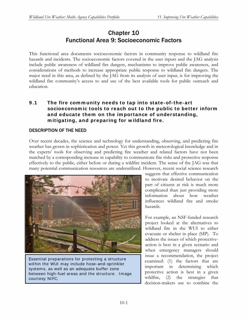
Wildland Fire Weather: Multi-Agency Capabilities Portfolio 11. Improving Fire Weather Capabilities
10-1
Chapter 10 Functional Area 9: Socioeconomic Factors
This functional area documents socioeconomic factors in community response to wildland fire hazards and incidents. The socioeconomic factors covered in the user inputs and the JAG analysis include public awareness of wildland fire dangers, mechanisms to improve public awareness, and considerations of methods to increase appropriate public response to wildland fire dangers. The major need in this area, as defined by the JAG from its analysis of user input, is for improving the wildland fire community’s access to and use of the best available tools for public outreach and education.
9.1 The fire community needs to tap into state-of-the-art socioeconomic tools to reach out to the public to better inform and educate them on the importance of understanding, mitigating, and preparing for wildland fire.
DESCRIPTION OF THE NEED
Over recent decades, the science and technology for understanding, observing, and predicting fire weather has grown in sophistication and power. Yet this growth in meteorological knowledge and in the experts’ tools for observing and predicting fire weather and related factors have not been matched by a corresponding increase in capability to communicate fire risks and protective response effectively to the public, either before or during a wildfire incident. The sense of the JAG was that many potential communication resources are underutilized. However, recent social science research
suggests that effective communication to motivate desired behavior on the part of citizens at risk is much more complicated than just providing more information about how weather influences wildland fire and smoke hazards. For example, an NSF-funded research project looked at the alternatives to wildland fire in the WUI to either evacuate or shelter in place (SIP). To address the issues of which protective-action is best in a given scenario and when emergency managers should issue a recommendation, the project examined: (1) the factors that are important in determining which protective action is best in a given wildfire, (2) the strategies that decision-makers use to combine the
Essential preparations for protecting a structure within the WUI may include hose-and-sprinkler systems, as well as an adequate buffer zone between high-fuel areas and the structure. Image courtesy NIFC.
Wildland Fire Weather: Multi-Agency Capabilities Portfolio 11. Improving Fire Weather Capabilities
10-2
factors, and (3) the effect of uncertainty on the decisionmaking process. The experimental approach used interviews, static information boards, and an interactive wildfire simulator to elicit knowledge from both expert and novice decisionmakers in wildfire management (NSF 2007a). The study resulted in a typology of wildfire protective actions that includes a range of viable forms of SIP and discussed heuristics for guiding people through the options. The authors drew a key distinction between SIP as a backup plan when evacuation is perceived as too risky and SIP as an option to improve survivability of structures. The latter option has also been called “prepare, stay, and defend.” Where early evacuation is an option but residents choose SIP to try to protect their property, the authors raised a number of issues that require further exploration, such as structure defensibility, timing of protective actions, training residents to fight fires, and health issues. They discuss a list, prepared with input from experienced wildfire incident managers, of 31 factors for incident managers to consider when weighing recommendations and/or mandates for at-risk populations in WUI areas threatened by a wildfire (Cova et al. 2009).
CURRENT CAPABILITIES
DRI-CEFA. See general description of DRI-CEFA under Other Crosscutting Current Capabilities for Functional Area 1. As of fall 2007, CEFA has conducted three surveys to assess scientist/decision-maker partnerships and the use of climate information in planning for prescribed fires and decisions for managing wildfires (also called “wildland fire use”). NSF Research Grant: Managing Perceptions of Wildland Fire Risk. See description of this project under User Need 7.1. NWCG WUI Mitigation Committee. See chapter 1 for overview of the NWCG structure and functions. As of summer 2009, this standing committee under the Policy, Planning, and Management Branch of the NWCG had established a task force to consider policy guidance for incident managers in making decisions about protective actions, such as evacuate or SIP, to recommend or mandate for residents of communities in the path of a wildfire. An important element in mitigation is preparing a community plan prior to a fire incident. Reverse 911 Notification and Wildland Fires. Many counties utilize a reverse-911 notification process to inform citizens of impending dangerous events. Rather than the individual calling 911 to report an incident, 911 operators will call individuals once a dangerous event threatens their safety and will identify the need to evacuate or take cover. Unfortunately, people utilizing this process sometimes wait to receive the call before taking protective measures, even though they see and appreciate the danger long before the call is received. Setting Wildfire Evacuation Trigger Points Using Fire Spread Modeling and GIS. Cova et al. (2005) adapted the concept of evacuation trigger points in response to hurricanes threatening a coast area to apply to wildfires in the WUI. They present a method for delimiting wildfire evacuation trigger points using firespread modeling and a geographical information system (GIS). Using data on wind, topography, and fuel in conjunction with estimated evacuation time, a trigger buffer can be computed for a community whereby an evacuation is recommended if a fire crosses the edge of the buffer. A case study is presented for the Corral Canyon section of the 1996 Calabasas Fire near Malibu, California.
Wildland Fire Weather: Multi-Agency Capabilities Portfolio 11. Improving Fire Weather Capabilities
10-3
Wildland Fire Lessons Learned Center. See general discussion under Crosscutting Capabilities for Functional Area 2.
CAPABILITIES IN DEVELOPMENT
NICC/GACC Predictive Services Units. See general description of Predictive Services under Other Crosscutting Current Capabilities for Functional Area 1 and the description of the Predictive Services Program in chapter 1, Introduction. Predictive Services has been involved in the Firewise Program and is experimenting with “reverse 911” public communications via Internet and wireless social networking venues (e.g., Facebook and Twitter). However, capabilities beyond traditional means of disseminating fire weather forecasts, watches, warnings, and take-action instructions are still in the early phases of formulation and development. The Seven-Day Outlook is Predictive Services’ principal product for providing planning and preparation information and decision support to local communities and state/regional fire response resourcing efforts. NSF Research Grant: Emergent Behavior of Coupled Human-Landscape Systems. The premise of this project is that, although human populations and landscapes have been interacting for thousands of years, the strength of these interactions has been increasing. The consequences of these intensified interactions and the actions that society could take to affect their course remain largely unknown. To address this gap, the researchers will investigate the nature and types of behaviors that result when humans and landscapes closely interact. The approach will employ an integrated program of numerical model development, model testing, and individualized and classroom instruction and public outreach for two specific cases of human-landscape interaction: barrier island resorts, such as those on the U.S. East Coast, and mountainous WUIs such as on the margins of Los Angeles, California. Numerical models will be developed that include representations of both the behavior of economic and management actors and the ways in which landscapes respond to natural processes and human influence. The project plan also calls for substantial efforts to communicate the results and implications of the modeling work to other researchers, students, policy managers, and the general public (NSF 2007b). With respect to the WUI case, the proposal notes that the margins of mountain catchments offer attractive residential attributes, but development is subject to an array of significant hazards. In the model being developed for the WUI, shrub land vegetation grows between fires; wildfires consume vegetation and residences and promote erosion; landslides, floods and sediment-laden debris flows damage or destroy residences; developers build housing developments whose size and location are based on projected profits; and residents buy houses based on projected appreciation and attributes such as view and commute distance. Managers in the model approve developments; mitigate fires with prescribed burns; mitigate landslides, floods and debris flows with slope stabilization, debris basins, reservoirs, and channel stabilization and entrenchment; and suppress fires. Historical data on fires, floods, and urban expansion in Los Angeles will be used to test the model. The effect of urbanization on fire size and frequency will be investigated, as will the long-term change through space and time of the WUI under differing management strategies . WFDSS. See general description under Crosscutting Capabilities for Functional Area 3. OFCM-sponsored Working Group for Social Sciences. The OFCM is engaged in the improvement of meteorological services by coordinating with the federal agencies the incorporation of social science results into meteorological operations. After hosting an Exploratory Mini-Workshop
Wildland Fire Weather: Multi-Agency Capabilities Portfolio 11. Improving Fire Weather Capabilities
10-4
on May 3-4, 2010, the OFCM published the report, Framing the Questions – Addressing the Needs: Moving to Incorporate Social Science Results into Meteorological Operations/Services (http://www.ofcm.noaa.gov/r28-ssr/fcm-r28.htm). The origin for the Exploratory Mini-Workshop regarding the integration of social science research results into meteorological operations/services was the 58th Interdepartmental Hurricane Conference (IHC). One of the actions from the 58th IHC recommended that a comprehensive strategy be developed to guide interagency tropical cyclone research and development (R&D) over the next decade. That recommendation was subsequently supported by both of my key coordinating committees: the Interdepartmental Committee for Meteorological Services and Supporting Research and the Federal Committee for Meteorological Services and Supporting Research (FCMSSR). A key recommendation in the R&D plan that was published in February 2007, entitled Interagency Strategic Research Plan for Tropical Cyclones: The Way Ahead (http://www.ofcm.gov/p36-isrtc/fcm-p36.htm), was: “Results of social science research need to be an integral part of the hurricane forecast and warning program.” The Exploratory Mini-Workshop was ultimately driven in response to Action Item 2009-1.2 from the August 6, 2009, meeting of the Interdepartmental Committee for Meteorological Services and Supporting Research (ICMSSR). The action item stated, “The OFCM will organize an interagency exploratory meeting on the social science aspects of meteorological services and supporting research to facilitate the exchange of ideas and information.” Finally, recommendations from the 64th IHC held in Savannah, Georgia, March 1-4, 2010, echoed support for a social science workshop. Both the ICMSSR and attendees at the 64th IHC encouraged the weather community to further integrate social sciences into its operations and services.
CHALLENGES TO MEETING THE NEED
Advancing Protective Action Theory with wildfires as the threat. Cova et al. (2009) argue that a theoretical and conceptual frameworks is needed to reason about protective actions in response to wildfire in the WUI, with respect to both selecting one or more preferable options and assessing the benefit and cost of each one. Lindell and Perry (1992, 2004) developed the Protective Action Decision Model as a conceptual framework for understanding protective actions, but it has not been widely tested. There is also room to advance a Protective Action Theory framework by tailoring it to the wildfire case. For example, a significant difference between evacuate/SIP decisions in response to chemical spills/toxic plumes and in response to wildfires is that WUI residents have the added opportunity to defend their property against the threat. In their discussion of how Protective Action Decision Theory might be expanded for the case of wildfire in the WUI, Cova et al. (2009) asked what factors influence the decision to evacuate or seek shelter and how these factors combine into community and individual response choices. All aspects of the fire, including location, direction, behavior to forecasted winds, fuel patterns, lead time and topography, would need to be included in decision framework. However, the framework must also consider many aspects of the human dimension, including warning systems, quality and accessibility of in-place shelter, prior preparedness measures, exiting roads, fire-fighting resources, demographics, and legal and regulatory context, among others. The researchers offered a preliminary framework for aligning factors that should enter into an emergency manager’s decision on whether to request that a threatened population evacuate or seek shelter. New methods for incorporating shelter in wildfire planning. Cova eta al. (2009) concluded that it s better to develop a comprehensive wildfire protection plan for a community, which includes all
Wildland Fire Weather: Multi-Agency Capabilities Portfolio 11. Improving Fire Weather Capabilities
10-5
reasonable protective options, rather that channeling residents to a single option in advance of an event. They also argue for a community plan that specifically takes into account such relevant factors as home ignition zone, structure defensibility/vulnerability, demographics, special needs, and equipment and training. The authors stressed that this is a planning topic as much as a research topic because of the challenges in assessing how a comprehensive protective plan would work, as well as estimating the relative benefits and costs of the plan in different scenarios. Timing Wildfire Protective Actions. Many issues arise as to which protective action should be issued and when. In many cases the “when” question is as important as the action to be taken. Prior research supports the view that a late evacuation is dangerous (Handmer and Tibbits 2005), but there is little research on what constitutes “early” and “late” in different scenarios or across households. The binary early-late division seems simple enough when there is substantial time (early) or almost none (late), but a significant gray area exists in the middle where it is easy to make errors in timing. Cova et al. (2009) concluded that research on modeling wildfire protective-action trigger points (Cova et al. 2005; Dennison et al. 2007), as well as empirical studies on the timing of protective actions in past wildfires (Kim et al. 2006), may shed light on developing strategies for educating incident commanders and residents on when it is too late to evacuate or seek proximal refuge shelter. Compliance with Stay or Go Recommendations. One challenge with recommending more than one protective option to residents is that it can be difficult to assess “compliance” with the recommendation. In a traditional evacuation context, compliance is defined as the percentage of people that adopt a recommended protective action. For example, Dombroski et al. (2006) provide a method for comparing compliance with either an evacuation or SIP recommendation in the context of a radiological emergency. However, according to Cova et al. (2009) a recommendation to “evacuate or SIP” would lead to 100% compliance in all cases because these two categories exhaust the universe of protective options. If the recommendation is to, “evacuate early or SIP,” then evacuating too late could be viewed as noncompliance. For an Australian incident in which residents were told to “leave early or prepare, stay and defend”, noncompliance could be defined as either a late evacuation or failing to properly prepare and defend a home. Under the assumption that some means for pre-certifying WUI residents to defend their homes exists, then non-compliance might be defined as defending a home without proper training and certification. In any case, to bring wildfire protective recommendations in line with the wealth of research on compliance for other hazards, a suitable definition of compliance for recommendations that allow more than one option will need to be developed (Cova et al. 2009). NSF Research Grant: Understanding Post-Exposure Risk Management Decisions: How Affect and Uncertainty Modulate Risk Appraisals and Subsequent Risk Management Choices. This project addressed the question of whether residents of the WUI who have suffered property loss from a wildfire will incorporate learning from their experience in their decisions whether, where, and how to rebuild. Past research involving perception of risk after wildfire exposure reveals two contrasting tendencies. One tendency, which researchers call a postexposure wake-up call, is characterized by greater risk awareness, heightened risk perception, and a strong desire to take proactive measures to better understand and mitigate future exposure. Contrasting sharply with the wake-up call phenomenon is a nearly opposite response, which researchers call a postexposure letdown. When this response dominates, people actually feel safer after an adverse event occurs; they perceive themselves to have been the victims of an unfortunate low-probability event, and they believe that the worst is over (i.e., “lightning doesn’t strike in the same place twice”). As a result,
Wildland Fire Weather: Multi-Agency Capabilities Portfolio 11. Improving Fire Weather Capabilities
10-6
people experiencing a letdown are unlikely to invest in costly and/or time-consuming measures to lower their future risks or to consider response strategies for future wildfires. The research team studied these two contrasting tendencies in human behavior among the residents of Kelowna, British Columbia, after a serious of devastating wildfires in 2003 caused the evacuation of over 45,000 Kelowna residents, three deaths, and the destruction of over 300 homes and many businesses (NSF 2009b). Results from this study and two others on people’s responses to wildfire risks were presented by Arvai et al. (2009), with the goal of improving understanding of the difficulties faced by forest managers in making wildfire risk management decisions. One of the studies showed that both the experts and the public tend to emphasize uncontrollable factors when asked to consider the causes of wildfires. The second study revealed the large role played by emotional responses, such as post-exposure wakeup call versus letdown, in judgments about wildfire risks. The third study showed that preferences for risk management options vary in response to even slight shifts in how presentation of the options is framed. In contrast to previous studies that call for improved public education about wildfire, the authors concluded that their results emphasize improving the processes used to inform both expert and public decisionmaking for fire risk management.
Wildland Fire Weather: Multi-Agency Capabilities Portfolio 11. Improving Fire Weather Capabilities
11-1
Chapter 11 Improving Fire Weather Capabilities
within the NWCG Structure
Chapter 1 introduced the multi-agency partnership for wildland fire management and the diverse, decentralized R&D community that improves and expands the capabilities described in chapters 2 through 10. The focal point for planning and conducting coordinated activities in this structure is the National Wildfire Coordinating Group (NWCG), so for brevity this discussion will refer to the entire partnership and coordination structure as the NWCG structure. As noted in chapter 1, the participants in that structure have been engaged since at least 2007 in a major reorganization and streamlining effort to make the coordination of wildland fire management, incident response, and R&D more efficient and effective for all participants and the entire wildland fire community. Fire weather capabilities—and the R&D to improve them—are and should be integral supporting players in the overall mission of the NWCG. Fire weather R&D should therefore be coordinated in the context of this existing structure, which coordinates wildland fire management R&D in general. Chapter 1 also noted that fire weather R&D is being conducted within two broader R&D communities: the R&D community for wildland fire management—exemplified by the JFSP, FCAMMS, and research centers and institutes focused on understanding and managing the wildland fire hazard—and the meteorological and Earth science R&D community represented by entities within or affiliated with NOAA/NWS. Between these communities, there are already many points of intersection and active collaboration on a project or program basis. There are also many working partnerships at multiple levels between NOAA/NWS operational units and operational units in the wildland fire management structure, such as the Predictive Services Program. An ongoing and long-term goal should be to expand and improve these points of intersection into a coordinated interface across the two communities, maximizing the synergy from their respective strengths.
OPPORTUNITIES FOR FURTHER COORDINATION AND COLLABORATION—NEAR-TERM
Near term actions for fire weather R&D coordination is aimed to reap the greatest potential benefit from completing and coordinating capability improvements that are already in progress and that address urgent needs identified by the NWFWNA. For discussion with the wildland fire community, OFCM has tentatively identified four objectives ranked in the near term:
To meet multiple user needs in Functional Area 3, ensure that IMET training and certification activities that support NWS Policy Directive 10-4 and its implementing procedural directives have the resources to provide meteorological support to requesting Incident Teams. Among the resources available to achieve this priority are three of the Training and Education entries in the matrix of capabilities in appendix D:
NWS Fire Weather Training for WFO & IMET
UCAR COMET Fire Weather Courses
Wildland Fire Lessons Learned Center
Wildland Fire Weather: Multi-Agency Capabilities Portfolio 11. Improving Fire Weather Capabilities
11-2
Support the work of the task force, established under the NWCG WUI Mitigation Committee, to examine policy and procedures for evacuation/shelter-in-place decisions and dissemination of decisions to at-risk populations. In particular, what fire weather-related products and services can contribute to timely and appropriate decisions?
Review ongoing model and forecast validation/verification activities. Validation and verification of NWS Fire Weather Forecasts are essential to addressing User Needs 3.3.a and 3.3.b, both of which were judged to be urgent needs by the JAG(NWFWNA). Validation and verification activities must be more than a pro forma exercise producing results that merely fulfill a program requirement. Are these results feeding back into activities to improve the next generation of models and the skill level of forecasts on parameters of real value to the wildland fire user community? If potent feedback loops are established and maintained now, the entire community will reap the benefits of more useful and reliable forecasts in the near to mid term.
As a potential source of best practices to be adopted more widely by NWS regions and WFOs across the United States, review approaches used by NWS Western Region Headquarters and Western Region WFOs in their Fire Weather Programs. In particular, are there best practices that could be adopted more widely to improve coordination between WFOs and the Predictive Services units at the regional GACC?
The following user needs identified as urgent by the JAG(NWFWNA) appear to be within technical reach of the capabilities discussed in this report.
User Need 1.1.b. A centralized means of reliably retrieving validated observation data is needed. The FAMWEB Data Warehouse (FDW) described in chapter 2 is available in a test version on the FAMWEB site (http://fam.nwcg.gov/fam-web/). Password protection is still a requirement for the FDW, which NWFWNA respondents viewed as a difficulty for accessing, for example, RAWS data from the WFMI website. However, the technical feasibility of a useful capability that addresses User Need 1.1.b has been established.
User Need 5.1. A coordinated, “one-stop” fire weather Internet presence is needed to facilitate fire weather user access to pertinent weather data and products for their region of interest. This User Need is obviously closely linked with User Need 1.1.b. A key question to take to the user community is whether the FDW as it is being implemented/tested looks like the answer to this need. Can one nationwide Internet site, perhaps with drill-down to geographic localities, meet this need, or is a more decentralized approach required to provide the most current data quickly? What is the best way to get highly “local” weather data and products to the user community, through a single national site like the FDW site, or through a set of regional/local sites?
User Need 3.2.a. Existing training and reference material for products and services need to be made readily available to all interested users. Since the NWFWNA was conducted in 2006-2007, the Predictive Services Program, the NWCG Training Working Team, and the NWS/COMET training programs have been addressing this need. An evaluation is needed of how well current training capabilities and training/reference dissemination methods are succeeding in meeting the needs of the entire wildland fire community. Ease of access to both training resources and reference materials is essential, but “build it and they will come” is unlikely to be a
Wildland Fire Weather: Multi-Agency Capabilities Portfolio 11. Improving Fire Weather Capabilities
11-3
sufficient response to the user need. Are users of WFDSS adequately trained to make the most of its substantial technical advances over the systems it replaces? Beyond the UCAR/COMET course offerings and the interpretive guidance provided by Predictive Services units, can existing resources such as the Wildland Fire Lessons Learned Center be tapped to expand the reach of fire weather training and information dissemination to the broad wildland fire community? These are just some of the questions that an evaluation targeting User Need 3.2.a and related training/outreach needs should seek to answer.
User Need 3.3.c. Users value Red Flag Warnings and articulated the need for fire weather warnings at longer lead times and with the widest possible dissemination. As noted in the chapter 4 discussion of recent NWS improvements to Red Flag Warnings, the NWS issues Fire Weather Watches for lead-times longer than 24 hours. This User Need can be met by strengthening the coordination and communication between the local WFO that issues a warning or watch, the Predictive Services unit at the regional GACC, and wildland fire stakeholders in the affected counties. As noted above, there are best-practices lessons that can be learned by looking at areas where warning/watch information coordination and communication works well.
User Need 5.5.a. Wildland fire weather users require a robust continuity of operations plan for GOES-DCS. GOES-DCS is the satellite-based system for collecting data from RAWS sensors and relaying it to the NIFC and other RAWS-processing nodes. As of October 2009, a backup for GOES-DCS was still not operational.
OPPORTUNITIES FOR FURTHER COORDINATION AND COLLABORATION—MID-TERM
For purposes of this report, mid-term actions should be achieved in 2 to 5 years. Among the user needs deemed to be urgent by the JAG(NWFWNA) (see chapter 1 and Table 1), the following needs have relevant current and developing capabilities discussed in this report that suggest the need can be met (given adequate resources) within 2–5 years.
User Need 2.1.a. The interaction between fire potential, fire combustion, and atmosphere needs to be better understood and modeled. As discussed in the chapter 3 discussion of this user need, the JFSP and FCAMMS have ongoing R&D projects contributing to both fundamental understanding and modeling of the fire triangle as it applies to wildland fire. The coupled atmosphere-fire module being developed by NCAR as a WRF implementation is also likely to contribute to meeting this need. The JAG(NWFWNA) saw this urgent need as one that could have a partial solution in the near term but would also need longer-term R&D, such as the development of priority research topics by the Core Fire Science Caucus and the basic research funded by NSF research grants.
User need 4.1.a. Users overwhelmingly need higher resolution meteorological model fields in complex terrain and the tools and input data to understand fire behavior and smoke dispersion. As discussed in chapter 5, the FCAMMS, DRI-CEFA, and NCAR have been working on model improvements specifically relevant to this User Need. An updated evaluation of the status of current operational capabilities relative to users’ needs is needed to guide and prioritize the R&D activities at these and
Wildland Fire Weather: Multi-Agency Capabilities Portfolio 11. Improving Fire Weather Capabilities
11-4
other research centers. This evaluation should also assess how the results of recent research projects funded by JFSP and NSF could contribute to the applied R&D directed at operational improvements.
User Need 5.4. More products need to be available in low bandwidth formats for users using telephones and/or PDAs to receive the data. Low-bandwidth products accessible to on-site fire incident management team members, not just to IMETs
User Need 6.1.a. A review of training processes and programs for quality, availability, consistency, currency, and standards across the fire weather community is needed. Currently, fire weather training for the wildland fire community is conducted primarily by the NWS (see NWS Fire Training for WFO and IMET in chapter 4), UCAR-COMET, the Predictive Services Units at GACCs, and as part of the NWCG’s Training and Distance Learning programs. Although there is substantial informal interaction and communication among individuals responsible for the courses offered and cross-training of individuals, the JAG(NWFWNA) identified this review as one of two urgent needs in Functional Area 6. When a formal review is undertaken, it should also address User Need 6.2: Training agencies need to make better use of a full range of training delivery methods, with a particular focus on distance-learning needs.
OPPORTUNITIES FOR FURTHER COORDINATION AND COLLABORATION—LONG-TERM
For this report, long-term actions are those that requires R&D efforts now (often they are already in progress, although often with resource constraints) but is not expected to be implementable in a functionally useful form to the community for at least 5 years.
User Need 1.1.a. The “complete, real-time, observationally based, gridded characterization of the current atmosphere” called for in this user need is the Holy Grail of fire weather observational datasets. It will take a number of years of concerted effort—involving data management and coordination challenges as well as technical R&D work—to meet this observational data need for the entire United States. However, the Capabilities in Development discussed in chapter 2 under User Need 1.1.a, such as the 4D Weather Data Cube, an MPAR System Network, and the Nationwide Network of Observing Mesonets, and others, indicate that this goal is technically feasible, at least at a functionally valuable level of implementation. Ensuring that data are reliable (or “authoritative’) while also available to remote locations (e.g., Incident Teams) in near-real time will be a technical challenge. A series of interim capability implementations, successively building increments of capability on the prior implementation, is a reasonable developmental pathway. As noted in User Need 8.1, the JAG(NWFWNA) assessed the additional program resources to work toward this capability to be an urgent need for the wildland fire community, even while recognizing that achieving the capability is a long-term objective.
User Need 7.3. Users need more smoke management decision-support tools. As of October 2009, representatives from Predictive Services said that the BlueSky modeling system provides useful inputs for smoke management decisions, such as whether to proceed with a prescribed burn, but it was not yet at the level of a decision-support tool. Smoke modeling R&D continues at FCAMMS, DRI-CEFA, and the NWS
Wildland Fire Weather: Multi-Agency Capabilities Portfolio 11. Improving Fire Weather Capabilities
11-5
Environmental Modeling Center, but integration of a reliable smoke modeling system into a decision-support tool is needed. Incorporation of this capability into WFDSS is a possibility to be explored. The JAG(WFWNA identified this as an urgent need for which operational capability will likely develop incrementally over an extended period.
PROPOSED FUTURE ROLE FOR OFCM
An ongoing effort will be needed to improve communication and coordination among the agencies funding and/or conducting fire weather R&D. OFCM proposes to work within the NWCG structure to identify areas/programs for immediate implementation, as well as coordination of future supporting R&D efforts. In particular, OFCM is well situated to act as a liaison between NOAA/NWS and other participants in NWCG, especially Predictive Services and the wildland fire R&D programs of the Federal land management agencies, to help improve the fire weather aspects of the national wildland fire R&D investment.

Wildland Fire Weather: Multi-agency Capabilities Portfolio References
R-1
References
Arnold, H. 2009. Presentation by Mr. Herb Arnold, Program Manager, Remote Automated Weather Stations, U.S. Bureau of Land Management, to the Committee for Integrated Observing Systems, Office of the Federal Coordinator for Meteorological Services and Supporting Research, National Oceanic and Atmospheric Administration. July 13, 2009. Available in PDF on the OFCM website. www.ofcm.gov/cios/meetings/2009-02/Session%203/5-Arnold-BLM_Interagency%20RAWS%20Network%20-%20CIOS.pdf
Arvai, J., R. Gregory, D. Ohlson, B. Blackwell, and R. Gray. 2006. Letdowns, wake-up calls, and constructed preferences: People’s responses to fuel and wildfire risks. Journal of Forestry 104: 173–181.
Caldwell, D. 2009. The SAB’s Fire Weather Research Report: NOAA’s Initial Position and Future Strategy. Presentation to the NOAA Executive Panel, February 26, 2009.
Cova, T.J., P.E. Dennison, T.H. Kim, M.A. Moritz. 2005. Setting wildfire evacuation trigger points using fire spread modeling and GIS. Transactions in GIS 9(4): 603–617.
Cova, T.J., F. A Drews, L.K. Siebeneck, and A. Musters. 2009. Protective actions in wildfires: evacuate or shelter-in-place? Unpublished manuscript submitted to Natural Hazard Review. www.geog.utah.edu/~cova/cova-etal-nhr-2009.pdf
Dennison, P.E., T.J. Cova, and M.A. Moritz. 2007. WUIVAC: a wildland-urban interface evacuation trigger model applied in strategic wildfire scenarios. Natural Hazards, 40, 181–199.
Dombroski, M., B. Fischhoff, and P. Fischbeck. 2006. Predicting emergency evacuation and sheltering behavior: a structured analytical approach. Risk Analysis 26(6): 1675–1688.
FENWT (Fire Environment Working Team). 2007. RAWS/ROMAN Study Report. October 10, 2007. National Wildfire Coordination Group. www.nwcg.gov/teams/fenwt/raws-roman/report.pdf
FWC (Fire Weather Committee). 2008. Fire Weather Station Standards. www.fs.fed.us/raws/standards.shtml
FWRWG (Fire Weather Research Working Group). 2008. Fire Weather Research: A Burning Agenda for NOAA. A Report from the NOAA Science Advisory Board. October 22, 2008. www.sab.noaa.gov/Reports/Reports.html.
Handmer, J., and A. Tibbits. 2005. Is staying at home the safest option in bushfires? Historical evidence for an Australian approach. Environment Hazards 6: 81–91.
Interagency Agreement. 2008. Interagency Agreement for Meteorological and Other Technical Services among the Bureau of Land Management, Bureau of Indian Affairs, Fish and Wildlife Service, and National Park Service of the United States Department of the Interior and Forest Service of the United States Department of Agriculture and the
Wildland Fire Weather: Multi-agency Capabilities Portfolio References
R-2
National Weather Service of the National Oceanic and Atmospheric Administration, United States Department of Commerce. BLM Agreement No. 1422RA1080003. BIA Agreement No. RS08K42F01. FWS Agreement No. 982108K001. NPS Agreement No. F956080028. NWS Agreement No. 02 FedFire Weather 2008. PDF available at www.srh.noaa.gov/images/ffc/pdf/firewx_agree2008.pdf.
Kim, T., T.J. Cova, and A. Brunelle. 2006. Using exploratory animation to analyze wildfire protective action recommendations. Natural Hazards Review 7: 1–11.
Lindell, M.K., and R.W. Perry. 1992. Behavioral Foundations of Community Emergency Planning. Washington, DC: Hemisphere Press.
Lindell, M.K., and R.W. Perry. (2004). Communicating Environmental Risk in Multiethnic Communities. Thousand Oaks, Calif.: Sage Publications.
MesoWest. 2010a. MesoWest Main Help. http://www.met.utah.edu/mesowest/help/index.html. Accessed 1/21/2010.
MesoWest. 2010b. MesoWest Networks. http://mesowest.utah.edu/index.html. Accessed 1/21/2010.
NICC (National Interagency Coordination Center). 2009. Predictive Services: Decision Support for Proactive Wildland Fire Management. http://www.nifc.gov/nicc/predictive/NPSG/FMT_PredictiveServices.pdf
NPSS (National Predictive Services Subcommittee). 2009. Predictive Services Handbook. Updated 2009. http://www.predictiveservices.nifc.gov/NPSG/npsg_pdf/PSHandbook_2009Update.pdf
NRC (National Research Council). 2009. Observing Weather and Climate from the Ground Up: A Nationwide Network of Networks. Board on Atmospheric Sciences and Climate, Committee on Developing Mesoscale Meteorological Observational Capabilities to Meet Multiple National Needs. Washington DC: National Academies Press.
NSF (National Science Foundation). 2003. Award Abstract #0353480. Understanding post-exposure risk management decisions: How affect and uncertainty modulate risk appraisals and subsequent risk management choices. NSF Division of Social and Economic Studies. Start date December 1, 2003. http://www.nsf.gov/awardsearch/showAward.do?AwardNumber=0353480
NSF 2007a. Award Abstract #0653752. Protective action decision making in wildfires. NSF Division of Civil, Mechanical, and Manufacturing Innovation. Start date July, 1, 2007. http://www.nsf.gov/awardsearch/showAward.do?AwardNumber=0653752
NSF 2007b. Award Abstract #0642796. Emergent behavior of coupled human-landscape systems. NSF Division of Earth Sciences. Start date August 1, 2007. http://www.nsf.gov/awardsearch/showAward.do?AwardNumber=0642796
Wildland Fire Weather: Multi-agency Capabilities Portfolio References
R-3
NSTC (National Science and Technology Council). 2005. Strategic Plan for the U.S. Integrated Earth Observation System. Interagency Working Group on Earth Observations, Committee on Environment and Natural Resources, NTSC. Washington, D.C. http://usgeo.gov/docs/EOCStrategic_Plan.pdf
NWCG (National Wildfire Coordinating Group). 2008a. NWFEA Overview: National Wildland Fire Enterprise Architecture. http://www.nwcg.gov/nwfea/index.html Accessed 9/30/2008.
NWCG. 2008b. National Wildland Fire Enterprise Architecture. NWFEA Blueprint Part I: Goals and Recommendations. Version 2.9. July 1, 2008. NWFEA Project Team, NIFC. Boise, Idaho: National Interagency Fire Center. PDF available at www.nwcg.gov/nwfea/blueprint.html.
NWCG. 2008c. NWCG Fire Weather Station Standards. PMS 426-3. Boise, Idaho: National Wildfire Coordinating Group. PDF of latest revision available at www.fs.fed.us/raws/standards.shtml
NWS (National Weather Service of the National Oceanic and Atmospheric Administration, U.S. Department of Commerce). 2006. Fire Weather Services On-Site Support. National Weather Service Instruction 10-402, October 4, 2006. PDF available at: http://www.weather.gov/directives/010/010.htm.
NWS. 2007. Fire Weather Services Annual Operating Plan and Report. National Weather Service Instruction 10-404, July 9, 2007. PDF available at http://www.weather.gov/directives/010/010.htm.
NWS. 2009a. Products and Services to Support Fire and Other Incidents. National Weather Service Policy Directive 10-4, September 8, 2009. PDF available at: http://www.weather.gov/directives/010/010.htm.
NWS. 2009b. Fire Weather Services Product Specification. National Weather Service Instruction 10-401, February 25, 2009. PDF available at http://www.weather.gov/directives/010/010.htm.
OFCM (Office of the Federal Coordinator for Meteorological Services and Supporting Research). National Wildland Fire Weather: A Summary of User Needs and Issues. 3 July 2007. Silver Spring, Maryland.
USDA (United States Department of Agriculture). 2001. National Fire Plan Research and Development: 2001 Business Summary. North Central Research Station, Forest Service, USDA. PDF available at http://nrs.fs.fed.us/pubs/1005
Vaisala. 2008. Vaisala’s NLDN U.S. National Lightning Detection Network. Reference B210412EN-E. Helsinki, Finland, and Tucson, Arizona: Vaisala, Inc. Available at the Vaisala NLDN website: http://www.vaisala.com/weather/products/lightning/knowledgecenter/aboutnldn

Wildland Fire Weather: Multi-agency Capabilities Portfolio References
R-4
Winter, P.L., and H Bigler-Cole. 2007. The National Predictive Services User Needs Assessment: Final Report. July 12, 2007. http://www.predictiveservices.nifc.gov/NPSG/npsg_pdf/NPSG_User_Needs_Assessment_Final_Report_Full_Version.pdf
Appendix A
Western Governors’ Association Policy Resolution 05-04

Western Governors’ Association Policy Resolution 05-04
June 14, 2005 Breckenridge, Colorado
National Wildland Fire Weather Program
A. BACKGROUND 1. As a consequence of decades of fuel accumulation in our nation’s forests and rangelands
coupled with persistent drought, state and federal fire managers are faced with larger, more explosive, and more costly wildfires than in any period in history.
2. Catastrophic wildfire is a growing national issue, demonstrated by the Florida wildfires in
1998 and 1999 and wildfires in Western states over the past five years. Between 2000 and 2004, Western states experienced severe fire seasons that set new benchmarks in terms of damages, losses, and cost.
3. Large, damaging wildfires are costly to suppress, and they can also cause severe
economic impacts to communities and state economies. Based on the experience over the last decade, 98% of wildfires are successfully extinguished during initial attack, however, 80% of wildfire costs are incurred when managing the 2% of wildfires which grow into large fires. Over the 5-year period from 2000-2004, federal wildfire suppression costs averaged $1.16 billion per year and are rising. With the addition of state and local fire suppression efforts, these costs likely approach $2 billion in severe years. Public health impacts are also increasing as the population increases in the wildland urban interface areas and smoke dispersion from wildfires and prescribed fires impact vulnerable citizens with respiratory ailments.
4. In order to reduce the risk of loss, the fire management agencies in the United States have
begun moving aggressively to deal with the tremendous accumulation of biomass which contributes to unwanted wildfire behavior. Much of this work is accomplished through prescribed fire projects and increasingly the management of natural ignitions.
5. In order to effectively and cost-efficiently manage and suppress wildfires, including
through the use of prescribed fire, it is critical that fire managers have timely, accurate and detailed information regarding current and predicted fire weather and associated climate services. The National Oceanic and Atmospheric Administration’s (NOAA’s) National Weather Service (NWS), through its fire weather program, is the national agency in the Department of Commerce (DOC) which provides this critical information. The federal wildland fire agencies’ Predictive Services integrate weather, climate and fuels information into fire environment products for the allocation and prioritization of fire management resources. The fire environment refers to those elements comprising fire meteorology, fire climatology, fire danger, fire behavior and fuel conditions as derived from weather and climate.
Western Governors’ Association Resolution 05-04
Wildland Fire Weather: Multi-agency Capabilities Portfolio Appendix A
A-1
6. NOAA’s NWS does not have a clear, legislative mandate or identified funding line items to operate its fire weather program. As a consequence, their capability to support sound fire management decisions may not be able to keep pace with the increasing demands.
7. The current NWS policy on issuing site-specific spot forecasts is to only issue spot
forecasts for prescribed burns for federal lands and federal assets, and for requests from public safety officials. Unless a state or local government can represent that there is a public safety concern or that federal assets are at risk, state and local governments must pay the private sector for spot forecasts.
8. Coordination currently exists on the operational side of wildland fire programs,
including:
• The Wildland Fire Leadership Council (WFLC) was established in April 2002 by a Memorandum of Understanding between the Secretaries of Agriculture and the Interior. The purpose of the council is to support the implementation and coordination of the National Fire Plan and the Federal Wildland Fire Management Policy.
• The National Wildfire Coordinating Group (NWCG) – the purpose of NWCG is to coordinate programs of the participating wildfire management agencies so as to avoid wasteful duplication and to provide a means of constructively working together. The NWCG’s Fire Environment Working Team (FENWT) was recently created to provide strategic guidance to Fire Danger, Fire Weather, and Fire Behavior issues and includes NOAA’s NWS.
• The National Interagency Fire Center (NIFC) in Boise, Idaho is the nation’s support center for wildland fire management. Seven federal and state agencies work together at NIFC to coordinate and support wildland fire and disaster operations.
9. To increase the fire community’s ability to plan and mitigate our Nation’s fire and fuel
problem, federal research entities were established to study fire and its effects. These research stations operate mainly within the USFS and have broad missions and goals. Valuable research is also being done at Universities, the University Corporation for Atmospheric Research (UCAR), NOAA, NASA, United States Geological Survey (USGS), the Environmental Protection Agency (EPA) and the private sector.
10. Despite current research programs on fire weather and fire environment, additional
research and better coordination of existing research is needed to improve decision support for decision-makers charged with protecting the public and our natural resources. At the present, there is inefficient communication and collaboration on problem-solving between science and fire weather operations.
11. The fire weather observation network, called Remote Automated Weather System
(RAWS), is not integrated into a comprehensive observing strategy, for example as part of the Integrated Surface Observing System (ISOS) and Global Earth Observing System of Systems (GEOSS).
Western Governors’ Association Resolution 05-04
Wildland Fire Weather: Multi-agency Capabilities Portfolio Appendix A
A-2
12. Fire Weather information is critical for effective wildland fire managers and for the
safety of firefighters. However, methods for using fire weather information are subjective and have changed little in decades. The advent of digital weather databases, fire potential forecasts, and the improvements of high resolution multidisciplinary computer models puts this nation on the cusp of a quantum leap in decision-making tools to support fire operations.
13. The Western Governors’ Association (WGA) has related programs and resolutions that
complement a fire weather program. Goal One of the 10-Year Comprehensive Strategy (A Collaborative Approach for Reducing Wildland Fire Risks to Communities and the Environment) calls for improved prevention and suppression strategies, and Goal Two speaks to reducing fuels in the wildland urban interface. The WGA resolution regarding drought (02-02) recognizes the relationship between drought and wildfire, stating that “extremely dry conditions have led to numerous forest and rangeland fires, burning tens of thousands of acres of land, destroying homes and communities, and eliminating critical habitats for wildlife and grazing lands for livestock.” Finally, the Governors created the Western Regional Air Partnership (WRAP) for the purpose of developing data, tools, and policies needed by states and tribes to improve visibility in parks and wilderness areas across the West.
B. GOVERNORS’ POLICY STATEMENT
1. Operational fire managers need improved products and services from NOAA’s National
Weather Service (NWS) which can be seamlessly infused into fire operations decision-making. To ensure the program has proper attention and funding, the Governors urge Congress to legislatively add fire weather including support for wildfire and prescribed fire management to federal, state, and local government agencies as a core mission of NWS and carry it as a funded line item in their appropriations.
2. The Western Governors urge NOAA to:
• Incorporate a robust national wildfire and prescribed fire weather program into its strategic plan, and its 5 and 20 year research plans, and funding requests.
• Complete a National Needs Assessment Report, by NOAA’s Office of the Federal Coordinator for Meteorology, of federal, state and local fire managers needs for weather information in their wildfire and prescribed fire decision making processes and a framework to meet those needs by the NWS and Predictive Services.
• Enhance and incorporate the fire weather observational network (RAWS) through agreements with the land management agencies into an integrated surface observing strategy, for example through ISOS and GEOSS.
3. The Western Governors believe an integrated fire weather and fire environment research
program is critical for the effective management and health of U.S. forests and rangelands. To ensure the program has proper attention and funding, the Governors urge Congress to legislatively direct the National Academy of Sciences to conduct a review of
Western Governors’ Association Resolution 05-04
Wildland Fire Weather: Multi-agency Capabilities Portfolio Appendix A
A-3
the research programs related to fire weather and fire environment (including Department of Agriculture, Department of the Interior, EPA, NOAA, NASA, and academia). This review should focus primarily on the coordination process between research programs and on processes to transfer research results into fire operations.
4. The Western Governors believe the nation would reap significant economic benefits by a
new joint interagency effort to transfer new digital weather information and technology into operational fire management decision-making and planning. This new effort would have a high economic return on investment and significant public health benefits from improved smoke dispersion forecasts. The Governors urge Congress to legislatively identify and fund NOAA to organize a new joint interagency effort for improved fire weather, fire environment and smoke dispersion information with NOAA, USFS, DOI, EPA, NASA, states, and other federal and non-federal stakeholders to:
a. Facilitate, integrate and transfer new science and technology into wildfire and
prescribed fire operations b. Perform verification, validation, evaluation and assessment of operational fire
weather data, products and applications. c. Provide science and technology training for forecasters and fire management
decision-makers, technical support for new decision-support tools, and grant support for joint collaborative applied fire weather and fire environment science research.
5. The Western Governors believe the new robust applied fire weather, fire environment
and smoke dispersion program needs to be effectively leveraged, integrated and coordinated with the 10-Year Comprehensive Strategy, the WGA drought program, and WRAP.
6. The Western Governors believe that weather, climate and hydrology data generated by
the federal government should be available to all levels of government in an open and unrestricted manner. The Governors oppose making such data available only to the private sector for purposes of resale to states and local governments.
C. GOVERNORS’ MANAGEMENT DIRECTIVE 1. The Western Governors’ Association (WGA) shall post this resolution to its Web site to
be referred to and transmitted as necessary. 2. WGA staff shall work with the states, the appropriate federal agencies, and Congress to
implement this resolution. F:\05resos\fire-weather4.doc
Western Governors’ Association Resolution 05-04
Wildland Fire Weather: Multi-agency Capabilities Portfolio Appendix A
A-4
Wildland Fire Weather: Multi-Agency Capabilities Portfolio
B-1
Appendix B
SECTION V. SUMMARY OF RECOMMENDATIONS
FROM FIRE WEATHER RESEARCH: A BURNING AGENDA FOR NOAA
A REPORT FROM THE NOAA SCIENCE ADVISORY BOARD
OCTOBER 22, 2008
The Fire Weather Research Working Group (FWRWG) has developed 46 recommendations in responding to the Terms of Reference and Charge provided by the NOAA Science Advisory Board. For convenience, a list of all 46 recommendations is provided here, retaining the finding number to which they apply. The eleven highest priority recommendations are shown in bold text: 1.1…Conduct detailed case studies of the behavior of selected wildland fires as a function of the observed three-dimensional weather conditions with the goals of understanding fire-atmosphere interaction and validating numerical models. 1.2…Explore with the federal wildland management agencies through their Joint Fire Science Program and the National Science Foundation the establishment of a jointly-funded program of wildland fire-related weather research in federal agencies, universities and industry, to include laboratory and numerical modeling, instrumentation development, and comprehensive case studies. 1.3…Use satellite-derived estimates of fire radiative energy output to specify surface boundary conditions for the characterization of vertical atmospheric structure and transport over the fire. 1.4 … Partner with land management agencies for a series of large-scale controlled burns, conducted under well-characterized conditions and adequately instrumented to examine the response of such fires to three-dimensional atmospheric conditions. Joint development of a set of well-defined physical parameters for quantifying fire behavior under various three-dimensional atmospheric conditions is a necessary pre-condition to assessing the weather impact. 2.1 … Assimilate output from all available local observation sources, including data from surface-data networks, ground-based radars and profilers, UASs, and satellite sensors, when generating gridded nowcasting and forecasting products, and fire-danger maps. 2.2 … Explore the use of remote sensing methods, including ground-based radar, HALE UAS, and satellite (including high frequency fire detections and characterization from GOES), for sustained, continuous monitoring and forecasting of the tropospheric misoscale weather, surface conditions, and fire growth during ongoing wildland fires. 3.1 … Increase research and development of integrated fire weather modeling systems, for normal-to-exceptional fire weather conditions (extreme fire weather conditions may require special consideration), leveraging research expertise and capabilities where possible from other federal agencies, universities, and the private sector. The long range goals for this
Wildland Fire Weather: Multi-agency Capabilities Portfolio Appendix B
B-2
larger research community include accurate simulation of fire in complex terrain and, ultimately, the wildland-urban interface; NOAA’s weather prediction capabilities are central to attaining these goals. 4.1 … Partner with the federal wildland management agencies to establish a central data repository (i.e., an archive), with entries in a standard format, to facilitate post-fire analyses and assist in verification and validation studies. 4.2 … Explore and validate tools for generating, from coarser forecast grids, detailed weather grids incorporating terrain. 4.3 … Maintain gridded forecasts (and observed/analyzed weather) in a database to assist future fire model development and testing. 5.1 …Use data assimilation systems described in Recommendation 2.1 to generate high resolution fire danger maps. 5.2 … Use the existing NFDRS processor at the Scripps Experimental Climate Prediction Center or the Rocky Mountain Center to compute fire danger maps with sufficient frequency to depict diurnal variations that may affect fire potential. 6.1 … Use NCEP forecasts with the NFDRS, CFFDRS, and other such systems that require weather data provided by the NWS to generate short-to long-term fire weather and fire danger forecasts maps to meet the different spatial scale needs of federal, state and local fire managers. 6.2 … Make these products available through a web-based GIS platform for users to customize fire weather and fire danger maps to suit their spatial and temporal scales of interest. 6.3… Develop training plans and packages with the National Wildfire Coordinating Group to familiarize users with the forecast technology. 7.1 … Utilize ensemble forecasts to develop seasonal to interannual fire weather and fire danger maps. 7.2 … Provide a source of weather/climate forecasts for annual fire potential forecasts, particularly for ERC-G. 7.3 … Encourage further research and development of seasonal climate-related fire forecasts to meet strategic fire planning needs. 8.1 … Develop a standardized “intelligent assistant” or decision-support tool for the WFO forecaster replying to requests for spot forecasts from first respondents and for deployed IMETs providing weather support to Incident Commanders. 8.2 … Develop numerical prediction methods that provide a frequently updated sequence of misoscale and mesoscale forecasts to provide forecasters with the capability to anticipate extreme fire behavior with several hours notice.
Wildland Fire Weather: Multi-agency Capabilities Portfolio Appendix B
B-3
9.1 … Establish a national LDS managed with full resources, coordinated under one agency with a more robust telemetry. Data collection should be centralized for the continental U.S. as well as Alaska and Hawaii. 9.2 … Develop and validate better forecasts of lightning activity that have improved representation of ignition potential. Consider partnering with the interagency Predictive Services program fire potential product with regard to new ignitions. Develop a new lightning probability product, weighted toward forecasting dry thunderstorm lightning. 10. 1 … Continue to leverage research capabilities to help improve representation of smoke plumes from wildland fires in operational forecasting tools through its ongoing collaborations with NOAA, EPA, and USFS researchers. 10.2 … Encourage WFO forecasters and incident meteorologists to take an appropriate smoke management course to gain familiarity with the fuel consumption and smoke emissions tools used by land managers. 10.3 … Work with NIFC, EPA, FCAMMS, and state and local environmental and public health agencies to ensure that complete smoke and pollution information, including current speciated emissions data as well as predicted plume evolution, is gathered, processed, summarized, and made available to the public in a timely and easily accessible manner, preferably from a single information source, e.g., a smoke web site or a smoke information portal. 11.1… Disseminate IMET spot forecasts from the field via NOAA web and data-serving capabilities and consider providing automated email distribution/SMS notification of SPOT availability as is done with NHC products. 11.2… Provide fire weather forecast verification and validation information and include
performance standards for each forecast element; include spatial verification information and
spot and IMET forecast validation information in final (archival) documentation for all major
incidents. 12.1 … Explore emerging communication formats and low-bandwidth technologies with the goal of allowing fire managers to access site data and to initiate and receive both spot weather forecasts and extended nowcasts; emphasis should be placed on maximizing the capabilities of currently-available low-bandwidth wireless devices such as Blackberries, iPhones, PDAs, and cellular modem-equipped laptops. 13.1 … Develop and deploy improved data/information visualization tools for use by the interagency Predictive Services program, WFO forecasters, and deployed IMETs for decision making, forecasting, and briefings. 13.2 … Make fire weather products available through a web-based GIS platform for users to produce their own customized fire weather and fire danger maps to suit their spatial and temporal scales of interest.
Wildland Fire Weather: Multi-agency Capabilities Portfolio Appendix B
B-4
13.3 … Ensure its data and forecast products are compatible with protocols such as the Wildland Fire Decision Support System (WFDSS). 14.1 … Ensure availability of live weather data via the current FX-Net and subsequently the AWIPS II thin client to facilitate IMET support at fires. 15.1 … Continue, in collaboration with USGS, to develop thresholds of rainfall rates and totals for public warnings of impending debris flows. 15.2 … Continue to work with USGS on national implementation, but refine the concept of operations to minimize the handling of the data, the forecast, and the warning. 16.1 … Use its climate modeling capabilities to better understand the role of fire in the climate system; anticipate and prepare for increased threat from fire in the future; and, at regional scale, assess propensity for increased fire hazard as the global temperature warms, and winds and relative humidity patterns change.. 16.2 … Use fire detections from NOAA’s operational environmental satellites to develop a large-scale fire climate data record. 17.1 … Develop and formalize exchanges of operational and research personnel, to share knowledge about weather and climate aspects of wildland fire management and incorporate this knowledge into NOAA research and operations. 17.2 … Explore with other countries opportunities to collaborate on prescribed burns as experimental fires to test new tools, models, and techniques under real-world conditions. 18.1 … Increase its focus on fire weather support in the next update of its Strategic Plan, making fire weather a higher priority, and seeking additional authorization and funding as needed. 18.2 … Designate a research laboratory (one with an operational counterpart within the NWS, along the lines of the NSSL/SPC and AOML-HRD/NHC tandems) to lead its fire weather-related research and development efforts and provide it with appropriate budget and authority. 18.3 … Work with the federal fire agencies and other members of the National Wildfire Coordinating Group to determine a location for the fire weather test bed and a strategy to leverage funding to build and staff it. 18.4 … Institutionalize the local “fire season”, giving it the same priority and emphasis as “severe convective weather season (thunderstorms and tornadoes)”, “hurricane season”, and “winter weather season”. 18.5 … Provide enhanced support for fire weather forecasting in WFOs and IMET operations, including funding for training, necessary equipment maintenance and replacement, and current and future communications (including FX-Net)
Wildland Fire Weather: Multi-agency Capabilities Portfolio Appendix B
B-5
19.1 … Identify clearly its unique niches in operations and research in the fire weather area. Where necessary, it should seek the appropriate legislative authority from the Congress. 19.2 … Commission a survey of fire-weather-related research underway nationwide to identify potential leveraging opportunities. 19.3 … Establish formal, but flexible, partnerships with research organizations in the federal wildland management agencies and the university community in its efforts to develop new products and services, especially in the numerical modeling area and in the development of new aerial observing systems.

Appendix C
Correlation of FWRWG Recommendations with NWFWNA User Needs

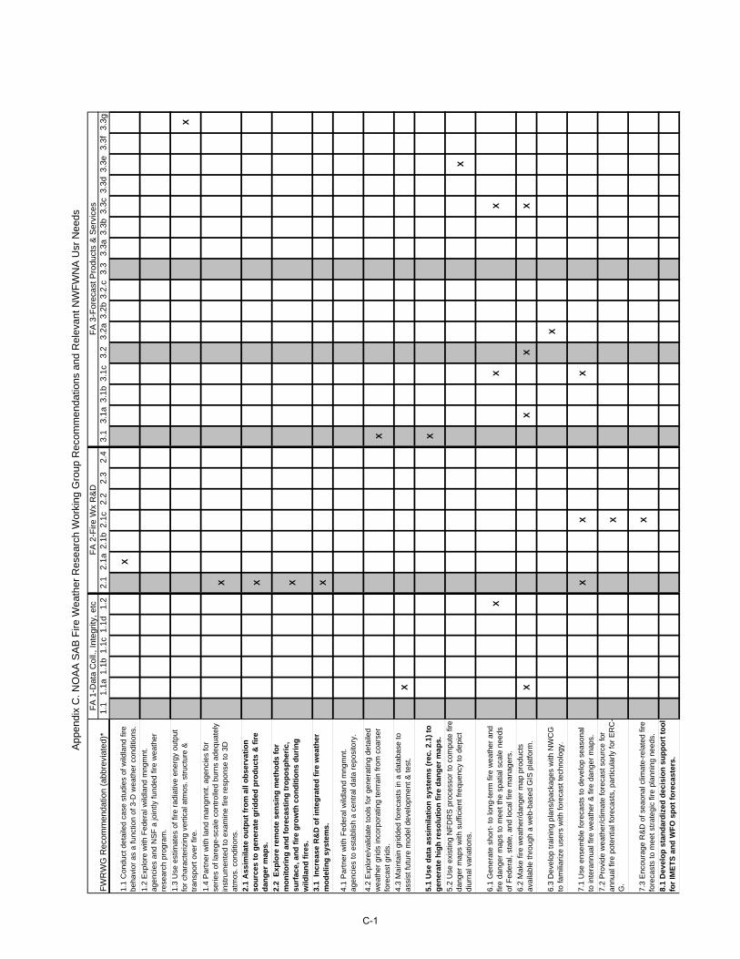
App
endi
x C
. NO
AA
SA
B F
ire W
eath
er R
esea
rch
Wor
king
Gro
up R
ecom
men
datio
ns a
nd R
elev
ant N
WF
WN
A U
sr N
eeds
FA
2-F
ire W
x R
&D
FA
3-F
orec
ast P
rodu
cts
& S
ervi
ces
FW
RW
G R
ecom
men
datio
n (a
bbre
viat
ed)*
1.1
1.1a
1.1b
1.1c
1.1d
1.2
2.1
2.1a
2.1b
2.1c
2.2
2.3
2.4
3.1
3.1a
3.1b
3.1c
3.2
3.2a
3.2b
3.2.
c3.
33.
3a3.
3b3.
3c3.
3d3.
3e3.
3f
3.3g
1.1
Con
duct
det
aile
d ca
se s
tudi
es o
f wild
land
fire
be
havi
or a
s a
func
tion
of 3
-D w
eath
er c
ondi
tions
.X
1.2
Exp
lore
with
Fed
eral
wild
land
mng
mnt
. ag
enci
es a
nd N
SF
a jo
intly
fund
ed fi
re w
eath
er
rese
arch
pro
gram
.
1.3
Use
est
imat
es o
f fire
rad
iativ
e en
ergy
out
put
for
char
acte
rizin
g ve
rtic
al a
tmos
. str
uctu
re &
tr
ansp
ort o
ver
fire.
X
1.4
Par
tner
with
land
man
gmnt
. age
ncie
s fo
r se
ries
of la
rege
-sca
le c
ontr
olle
d bu
rns
adeq
uate
ly
inst
rum
ente
d to
exa
min
e fir
e re
spon
se to
3D
at
mos
. con
ditio
ns.
X
2.1
Ass
imila
te o
utp
ut
fro
m a
ll o
bse
rvat
ion
so
urc
es t
o g
ener
ate
gri
dd
ed p
rod
uct
s &
fir
e d
ang
er m
aps.
X
2.2
Exp
lore
rem
ote
sen
sin
g m
eth
od
s fo
r m
on
ito
rin
g a
nd
fo
reca
stin
g t
rop
osp
her
ic,
surf
ace,
an
d f
ire
gro
wth
co
nd
itio
ns
du
rin
g
wild
lan
d f
ires
.
X
3.1
Incr
ease
R&
D o
f in
teg
rate
d f
ire
wea
ther
m
od
elin
g s
yste
ms.
X
4.1
Par
tner
with
Fed
eral
wild
land
mng
mnt
. ag
enci
es to
est
ablis
h a
cent
ral d
ata
repo
sito
ry.
4.2
Exp
lore
/val
idat
e to
ols
for
gene
ratin
g de
taile
d w
eath
er g
rids
inco
rpor
atin
g te
rrra
in fr
om c
oars
er
fore
cast
grid
s.X
4.3
Mai
ntai
n gr
idde
d fo
reca
sts
in a
dat
abas
e to
as
sist
futu
re m
odel
dev
elop
men
t & te
st.
X
5.1
Use
dat
a as
sim
ilati
on
sys
tem
s (r
ec. 2
.1)
to
gen
erat
e h
igh
res
olu
tio
n f
ire
dan
ger
map
s.X
5.2
Use
exi
stin
g N
FD
RS
pro
cess
or to
com
pute
fire
da
nger
map
s w
ith s
uffic
ient
freq
uenc
y to
dep
ict
diur
nal v
aria
tions
.X
6.1
Gen
erat
e sh
ort-
to lo
ng-t
erm
fire
wea
ther
and
fir
e da
nger
map
s to
mee
t the
spa
tial s
cale
nee
ds
of F
eder
al, s
tate
, and
loca
l fire
man
ager
s.
XX
X
6.2
Mak
e fir
e w
eath
er/d
ange
r m
ap p
rodu
cts
avai
labl
e th
roug
h a
web
-bas
ed G
IS p
latfo
rm.
XX
XX
6.3
Dev
elop
trai
ning
pla
ns/p
acka
ges
with
NW
CG
to
fam
iliar
ize
user
s w
ith fo
reca
st te
chno
logy
.X
7.1
Use
ens
embl
e fo
reca
sts
to d
evel
op s
easo
nal
to in
tera
nnua
l fire
wea
ther
& fi
re d
ange
r m
aps.
XX
X
7.2
Pro
vide
wea
ther
/clim
ate
fore
cast
sou
rce
for
annu
al fi
re p
oten
tial f
orec
asts
, par
ticul
arly
for
ER
C-
G.
X
7.3
Enc
oura
ge R
&D
of s
eaon
al c
limat
e-re
late
d fir
e fo
reca
sts
to m
eet s
trat
egic
fire
pla
nnin
g ne
eds.
X
8.1
Dev
elo
p s
tan
dar
diz
ed d
ecis
ion
su
pp
ort
to
ol
for
IME
TS
an
d W
FO
sp
ot
fore
cast
ers.
FA
1-D
ata
Col
l., In
tegr
ity, e
tc
C-1
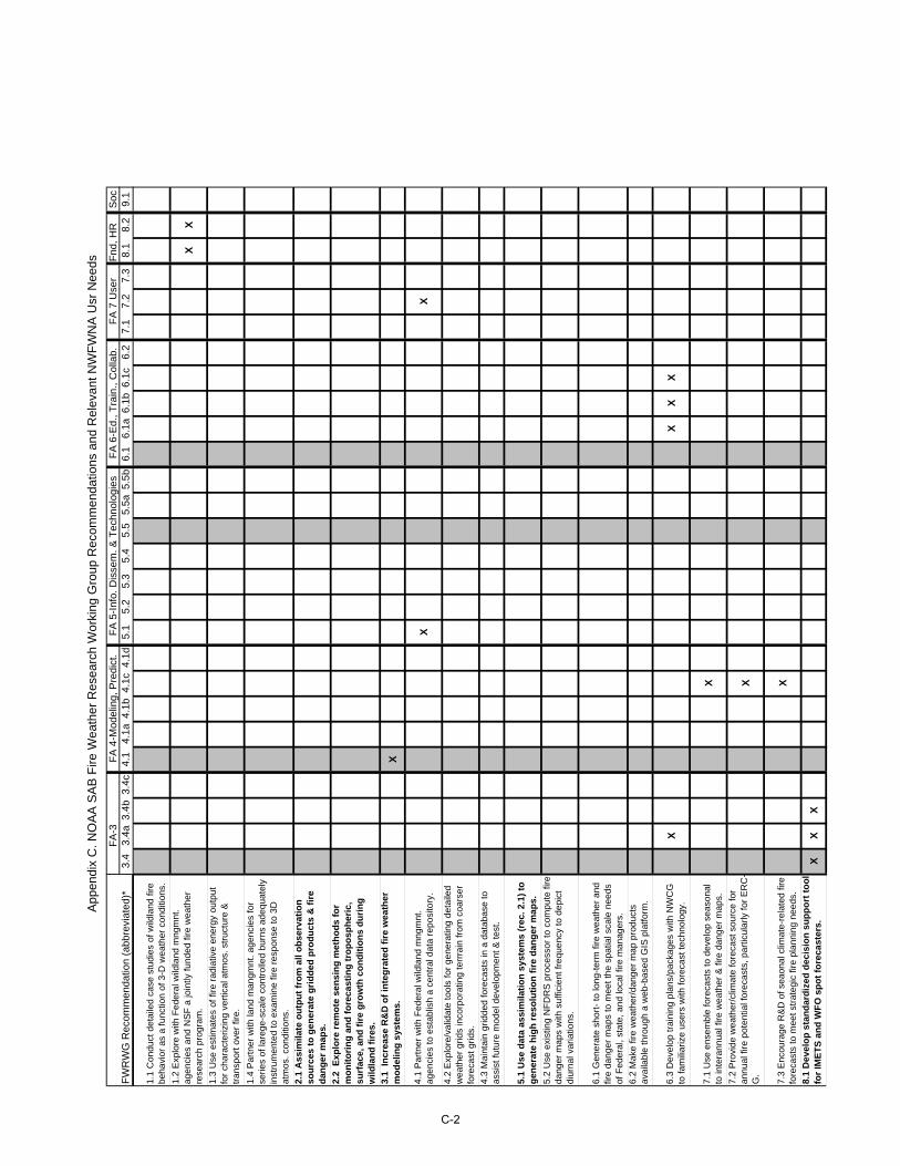
App
endi
x C
. NO
AA
SA
B F
ire W
eath
er R
esea
rch
Wor
king
Gro
up R
ecom
men
datio
ns a
nd R
elev
ant N
WF
WN
A U
sr N
eeds
FW
RW
G R
ecom
men
datio
n (a
bbre
viat
ed)*
1.1
Con
duct
det
aile
d ca
se s
tudi
es o
f wild
land
fire
be
havi
or a
s a
func
tion
of 3
-D w
eath
er c
ondi
tions
.
1.2
Exp
lore
with
Fed
eral
wild
land
mng
mnt
. ag
enci
es a
nd N
SF
a jo
intly
fund
ed fi
re w
eath
er
rese
arch
pro
gram
.
1.3
Use
est
imat
es o
f fire
rad
iativ
e en
ergy
out
put
for
char
acte
rizin
g ve
rtic
al a
tmos
. str
uctu
re &
tr
ansp
ort o
ver
fire.
1.4
Par
tner
with
land
man
gmnt
. age
ncie
s fo
r se
ries
of la
rege
-sca
le c
ontr
olle
d bu
rns
adeq
uate
ly
inst
rum
ente
d to
exa
min
e fir
e re
spon
se to
3D
at
mos
. con
ditio
ns.
2.1
Ass
imila
te o
utp
ut
fro
m a
ll o
bse
rvat
ion
so
urc
es t
o g
ener
ate
gri
dd
ed p
rod
uct
s &
fir
e d
ang
er m
aps.
2.2
Exp
lore
rem
ote
sen
sin
g m
eth
od
s fo
r m
on
ito
rin
g a
nd
fo
reca
stin
g t
rop
osp
her
ic,
surf
ace,
an
d f
ire
gro
wth
co
nd
itio
ns
du
rin
g
wild
lan
d f
ires
.
3.1
Incr
ease
R&
D o
f in
teg
rate
d f
ire
wea
ther
m
od
elin
g s
yste
ms.
4.1
Par
tner
with
Fed
eral
wild
land
mng
mnt
. ag
enci
es to
est
ablis
h a
cent
ral d
ata
repo
sito
ry.
4.2
Exp
lore
/val
idat
e to
ols
for
gene
ratin
g de
taile
d w
eath
er g
rids
inco
rpor
atin
g te
rrra
in fr
om c
oars
er
fore
cast
grid
s.
4.3
Mai
ntai
n gr
idde
d fo
reca
sts
in a
dat
abas
e to
as
sist
futu
re m
odel
dev
elop
men
t & te
st.
5.1
Use
dat
a as
sim
ilati
on
sys
tem
s (r
ec. 2
.1)
to
gen
erat
e h
igh
res
olu
tio
n f
ire
dan
ger
map
s.
5.2
Use
exi
stin
g N
FD
RS
pro
cess
or to
com
pute
fire
da
nger
map
s w
ith s
uffic
ient
freq
uenc
y to
dep
ict
diur
nal v
aria
tions
.
6.1
Gen
erat
e sh
ort-
to lo
ng-t
erm
fire
wea
ther
and
fir
e da
nger
map
s to
mee
t the
spa
tial s
cale
nee
ds
of F
eder
al, s
tate
, and
loca
l fire
man
ager
s.
6.2
Mak
e fir
e w
eath
er/d
ange
r m
ap p
rodu
cts
avai
labl
e th
roug
h a
web
-bas
ed G
IS p
latfo
rm.
6.3
Dev
elop
trai
ning
pla
ns/p
acka
ges
with
NW
CG
to
fam
iliar
ize
user
s w
ith fo
reca
st te
chno
logy
.
7.1
Use
ens
embl
e fo
reca
sts
to d
evel
op s
easo
nal
to in
tera
nnua
l fire
wea
ther
& fi
re d
ange
r m
aps.
7.2
Pro
vide
wea
ther
/clim
ate
fore
cast
sou
rce
for
annu
al fi
re p
oten
tial f
orec
asts
, par
ticul
arly
for
ER
C-
G.
7.3
Enc
oura
ge R
&D
of s
eaon
al c
limat
e-re
late
d fir
e fo
reca
sts
to m
eet s
trat
egic
fire
pla
nnin
g ne
eds.
8.1
Dev
elo
p s
tan
dar
diz
ed d
ecis
ion
su
pp
ort
to
ol
for
IME
TS
an
d W
FO
sp
ot
fore
cast
ers.
FA
-3F
A 4
-Mod
elin
g, P
redi
ct.
FA
5-I
nfo.
Dis
sem
. & T
echn
olog
ies
FA
6-E
d., T
rain
., C
olla
b.F
A 7
Use
rF
nd, H
RS
oc3.
43.
4a3.
4b3.
4c4.
14.
1a4.
1b4.
1c4.
1d5.
15.
25.
35.
45.
55.
5a5.
5b6.
16.
1a6.
1b6.
1c6.
27.
17.
27.
38.
18.
29.
1
XX
X
XX
XX
XX
X X X
XX
X
C-2
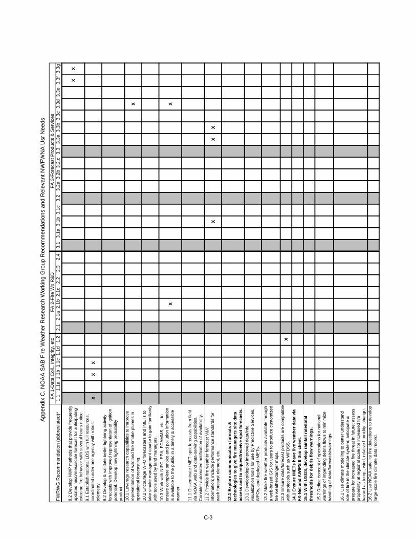
App
endi
x C
. NO
AA
SA
B F
ire W
eath
er R
esea
rch
Wor
king
Gro
up R
ecom
men
datio
ns a
nd R
elev
ant N
WF
WN
A U
sr N
eeds
FA
2-F
ire W
x R
&D
FA
3-F
orec
ast P
rodu
cts
& S
ervi
ces
FW
RW
G R
ecom
men
datio
n (a
bbre
viat
ed)*
1.1
1.1a
1.1b
1.1c
1.1d
1.2
2.1
2.1a
2.1b
2.1c
2.2
2.3
2.4
3.1
3.1a
3.1b
3.1c
3.2
3.2a
3.2b
3.2.
c3.
33.
3a3.
3b3.
3c3.
3d3.
3e3.
3f
3.3g
FA
1-D
ata
Col
l., In
tegr
ity, e
tc
8.2
Dev
elop
NW
P m
etho
ds th
at p
rovi
de fr
eque
ntly
up
date
d m
iso/
mes
osca
le fo
reca
st fo
r an
ticip
atin
g ex
trem
e fir
e be
havi
or w
ith s
ever
al h
ours
not
ice.
XX
9.1
Est
ablis
h na
tiona
l LD
S w
ith fu
ll re
sour
ces,
co
ordi
nate
d un
der
one
agen
cy w
ith r
obus
t te
lem
etry
. X
XX
9.2
Dev
elop
& v
alid
ate
bette
r lig
htni
ng a
ctiv
ity
fore
cast
s w
ith im
prov
ed r
epre
sent
aton
of i
gniti
on
pote
ntia
l. D
evel
op n
ew li
ghtn
ing
prob
abili
ty
prod
uct.
10.1
Lev
erag
e re
sear
ch c
apab
ilitie
s to
imrp
rove
re
pres
enta
tion
of w
ildla
nd fi
re s
mok
e pl
umes
in
oper
atio
nal f
orec
astin
g.
X
10.2
Enc
oura
ge W
FO
fore
cast
ers
and
IME
Ts
to
take
sm
oke
man
agem
ent c
ours
e to
gai
n fa
mili
arity
w
ith to
ols
used
by
land
man
ager
s.
10.3
Wor
k w
ith N
IFC
, EP
A, F
CA
MM
S, e
tc.,
to
ensu
re c
ompl
ete
smok
e an
d po
llutio
n in
form
atio
n is
ava
ilabl
e to
the
publ
ic in
a ti
mel
y &
acc
essi
ble
man
ner.
XX
11.1
Dis
sem
inat
e IM
ET
spo
t for
ecas
ts fr
om fi
eld
via
NO
AA
web
and
dat
a-se
rvin
g ca
pabi
litie
s.
Con
side
r au
tom
ated
not
ifica
tion
of a
vaila
bilit
y.
11.2
Pro
vide
fire
wea
ther
fore
cast
V&
V
info
rmat
ion;
incl
ude
perf
orm
ance
sta
ndar
ds fo
r ea
ch fo
reca
st e
lem
ent,
etc.
XX
X
12.1
Exp
lore
co
mm
un
icat
ion
fo
rmat
s &
te
chn
olo
gie
s to
giv
e fi
re m
anag
ers
site
dat
a ac
cess
an
d t
o r
equ
est/
rece
ive
spo
t fo
reca
sts.
13.1
Dev
elop
/dep
loy
impr
oved
dat
a/in
fo.
visu
aliz
atio
n to
ols
for
use
by P
redi
ctiv
e S
ervi
ces,
W
FO
s, a
nd d
eplo
yed
IME
Ts.
13.2
Mak
e fir
e w
eath
er p
rodu
cts
avai
labl
e th
roug
h a
web
-bas
ed G
IS fo
r us
ers
to p
rodu
ce c
usto
miz
ed
fire
wea
ther
/dan
ger
map
s.
13.3
Ens
ure
data
/fore
cast
pro
duct
s ar
e co
mpa
tible
w
ith p
roto
cols
suc
h as
WF
DS
S.
X
14.1
En
sure
IME
Ts
hav
e liv
e w
eath
er d
ata
via
FX
-Net
an
d A
WIP
S II
th
in c
lien
t.
15.1
Wit
h U
SG
S, d
evel
op
rai
nfa
ll ra
te/t
ota
l th
resh
old
s fo
r d
ebri
s fl
ow
war
nin
gs.
15.2
Ref
ine
conc
ept o
f ope
ratio
ns fo
r na
tiona
l w
arni
ngs
of im
pend
ing
debr
is fl
ows
to m
inim
ize
hand
ling
of d
ata/
fore
cast
s/w
arni
ngs.
16.1
Use
clim
ate
mod
elin
g to
bet
ter
unde
rsta
nd
role
of f
ire in
the
clim
ate
syst
em; a
ntic
ipat
e &
pr
epar
e fo
r in
crea
sed
fire
thre
at in
futu
re; a
sses
s pr
open
sity
at r
egio
nal s
cale
for
incr
ease
d fir
e ha
zard
as
tem
p., w
ind,
rel
ativ
e hu
mid
ity c
hang
e.
16.2
Use
NO
AA
sat
ellit
e fir
e de
tect
ions
to d
evel
op
larg
e-sc
ale
fire
clim
ate
data
rec
ord.
C-3
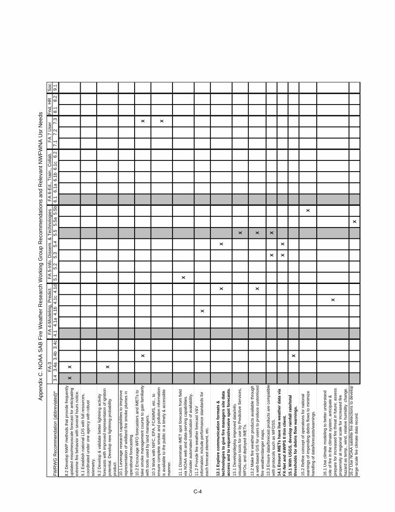
App
endi
x C
. NO
AA
SA
B F
ire W
eath
er R
esea
rch
Wor
king
Gro
up R
ecom
men
datio
ns a
nd R
elev
ant N
WF
WN
A U
sr N
eeds
FW
RW
G R
ecom
men
datio
n (a
bbre
viat
ed)*
8.2
Dev
elop
NW
P m
etho
ds th
at p
rovi
de fr
eque
ntly
up
date
d m
iso/
mes
osca
le fo
reca
st fo
r an
ticip
atin
g ex
trem
e fir
e be
havi
or w
ith s
ever
al h
ours
not
ice.
9.1
Est
ablis
h na
tiona
l LD
S w
ith fu
ll re
sour
ces,
co
ordi
nate
d un
der
one
agen
cy w
ith r
obus
t te
lem
etry
.
9.2
Dev
elop
& v
alid
ate
bette
r lig
htni
ng a
ctiv
ity
fore
cast
s w
ith im
prov
ed r
epre
sent
aton
of i
gniti
on
pote
ntia
l. D
evel
op n
ew li
ghtn
ing
prob
abili
ty
prod
uct.
10.1
Lev
erag
e re
sear
ch c
apab
ilitie
s to
imrp
rove
re
pres
enta
tion
of w
ildla
nd fi
re s
mok
e pl
umes
in
oper
atio
nal f
orec
astin
g.
10.2
Enc
oura
ge W
FO
fore
cast
ers
and
IME
Ts
to
take
sm
oke
man
agem
ent c
ours
e to
gai
n fa
mili
arity
w
ith to
ols
used
by
land
man
ager
s.
10.3
Wor
k w
ith N
IFC
, EP
A, F
CA
MM
S, e
tc.,
to
ensu
re c
ompl
ete
smok
e an
d po
llutio
n in
form
atio
n is
ava
ilabl
e to
the
publ
ic in
a ti
mel
y &
acc
essi
ble
man
ner.
11.1
Dis
sem
inat
e IM
ET
spo
t for
ecas
ts fr
om fi
eld
via
NO
AA
web
and
dat
a-se
rvin
g ca
pabi
litie
s.
Con
side
r au
tom
ated
not
ifica
tion
of a
vaila
bilit
y.
11.2
Pro
vide
fire
wea
ther
fore
cast
V&
V
info
rmat
ion;
incl
ude
perf
orm
ance
sta
ndar
ds fo
r ea
ch fo
reca
st e
lem
ent,
etc.
12.1
Exp
lore
co
mm
un
icat
ion
fo
rmat
s &
te
chn
olo
gie
s to
giv
e fi
re m
anag
ers
site
dat
a ac
cess
an
d t
o r
equ
est/
rece
ive
spo
t fo
reca
sts.
13.1
Dev
elop
/dep
loy
impr
oved
dat
a/in
fo.
visu
aliz
atio
n to
ols
for
use
by P
redi
ctiv
e S
ervi
ces,
W
FO
s, a
nd d
eplo
yed
IME
Ts.
13.2
Mak
e fir
e w
eath
er p
rodu
cts
avai
labl
e th
roug
h a
web
-bas
ed G
IS fo
r us
ers
to p
rodu
ce c
usto
miz
ed
fire
wea
ther
/dan
ger
map
s.
13.3
Ens
ure
data
/fore
cast
pro
duct
s ar
e co
mpa
tible
w
ith p
roto
cols
suc
h as
WF
DS
S.
14.1
En
sure
IME
Ts
hav
e liv
e w
eath
er d
ata
via
FX
-Net
an
d A
WIP
S II
th
in c
lien
t.
15.1
Wit
h U
SG
S, d
evel
op
rai
nfa
ll ra
te/t
ota
l th
resh
old
s fo
r d
ebri
s fl
ow
war
nin
gs.
15.2
Ref
ine
conc
ept o
f ope
ratio
ns fo
r na
tiona
l w
arni
ngs
of im
pend
ing
debr
is fl
ows
to m
inim
ize
hand
ling
of d
ata/
fore
cast
s/w
arni
ngs.
16.1
Use
clim
ate
mod
elin
g to
bet
ter
unde
rsta
nd
role
of f
ire in
the
clim
ate
syst
em; a
ntic
ipat
e &
pr
epar
e fo
r in
crea
sed
fire
thre
at in
futu
re; a
sses
s pr
open
sity
at r
egio
nal s
cale
for
incr
ease
d fir
e ha
zard
as
tem
p., w
ind,
rel
ativ
e hu
mid
ity c
hang
e.
16.2
Use
NO
AA
sat
ellit
e fir
e de
tect
ions
to d
evel
op
larg
e-sc
ale
fire
clim
ate
data
rec
ord.
FA
-3F
A 4
-Mod
elin
g, P
redi
ct.
FA
5-I
nfo.
Dis
sem
. & T
echn
olog
ies
FA
6-E
d., T
rain
., C
olla
b.F
A 7
Use
rF
nd, H
RS
oc3.
43.
4a3.
4b3.
4c4.
14.
1a4.
1b4.
1c4.
1d5.
15.
25.
35.
45.
55.
5a5.
5b6.
16.
1a6.
1b6.
1c6.
27.
17.
27.
38.
18.
29.
1
XX X
XX X
X
X
XX
X
XX
XX
XX
X
X
X
X
C-4
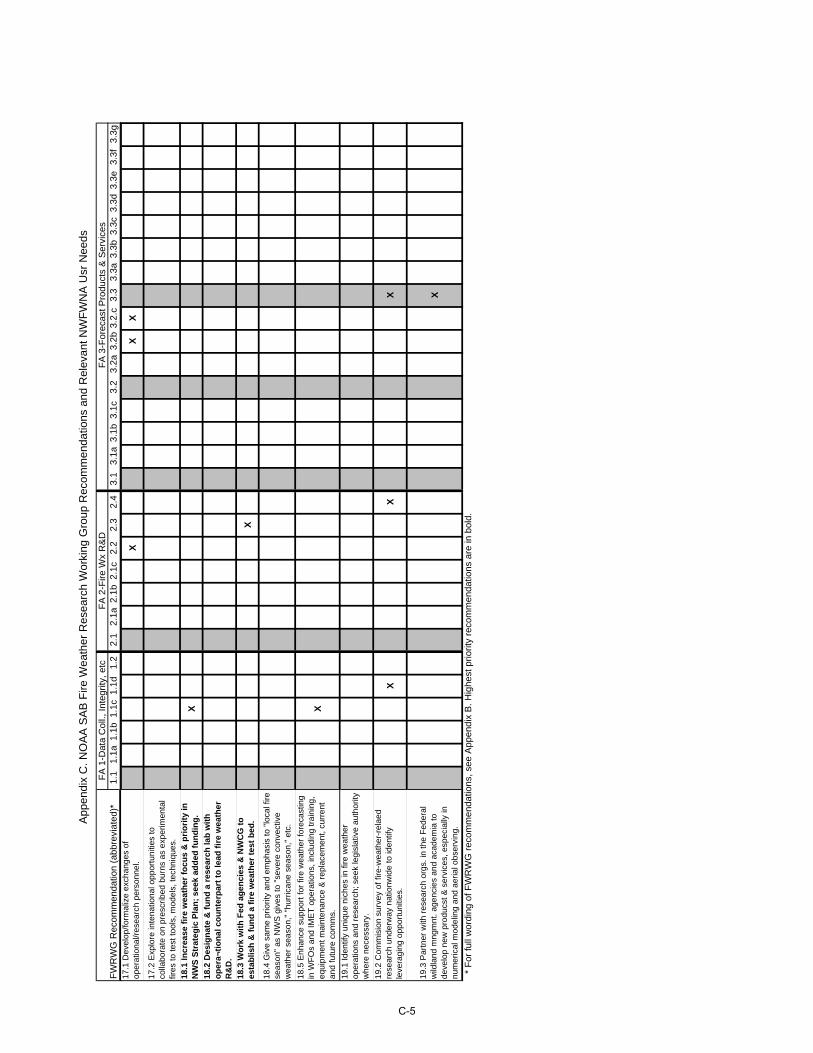
App
endi
x C
. NO
AA
SA
B F
ire W
eath
er R
esea
rch
Wor
king
Gro
up R
ecom
men
datio
ns a
nd R
elev
ant N
WF
WN
A U
sr N
eeds
FA
2-F
ire W
x R
&D
FA
3-F
orec
ast P
rodu
cts
& S
ervi
ces
FW
RW
G R
ecom
men
datio
n (a
bbre
viat
ed)*
1.1
1.1a
1.1b
1.1c
1.1d
1.2
2.1
2.1a
2.1b
2.1c
2.2
2.3
2.4
3.1
3.1a
3.1b
3.1c
3.2
3.2a
3.2b
3.2.
c3.
33.
3a3.
3b3.
3c3.
3d3.
3e3.
3f
3.3g
FA
1-D
ata
Col
l., In
tegr
ity, e
tc
17.1
Dev
elop
/form
aliz
e ex
chan
ges
of
oper
atio
nal/r
esea
rch
pers
onne
l.X
XX
17.2
Exp
lore
inte
natio
nal o
ppor
tuni
ties
to
colla
bora
te o
n pr
escr
ibed
bur
ns a
s ex
perim
enta
l fir
es to
test
tool
s, m
odel
s, te
chni
ques
.
18.1
Incr
ease
fir
e w
eath
er f
ocu
s &
pri
ori
ty in
N
WS
Str
ateg
ic P
lan
; se
ek a
dd
ed f
un
din
g.
X
18.2
Des
ign
ate
& f
un
d a
res
earc
h la
b w
ith
o
per
a¬ti
on
al c
ou
nte
rpar
t to
lead
fir
e w
eath
er
R&
D.
18.3
Wo
rk w
ith
Fed
ag
enci
es &
NW
CG
to
es
tab
lish
& f
un
d a
fir
e w
eath
er t
est
bed
.X
18.4
Giv
e sa
me
prio
rity
and
emph
asis
to "
loca
l fire
se
ason
" as
NW
S g
ives
to "
seve
re c
onve
ctiv
e w
eath
er s
easo
n,"
"hur
rican
e se
ason
," e
tc.
18.5
Enh
ance
sup
port
for
fire
wea
ther
fore
cast
ing
in W
FO
s an
d IM
ET
ope
ratio
ns, i
nclu
ding
trai
ning
, eq
uipm
ent m
aint
enan
ce &
rep
lace
men
t, cu
rren
t an
d fu
ture
com
ms.
X
19.1
Iden
tify
uniq
ue n
iche
s in
fire
wea
ther
op
erat
ions
and
res
earc
h; s
eek
legi
slat
ive
auth
ority
w
here
nec
essa
ry.
19.2
Com
mis
ion
surv
ey o
f fire
-wea
ther
-rel
aed
rese
arch
und
erw
ay n
atio
nwid
e to
iden
tify
leve
ragi
ng o
ppor
tuni
ties.
XX
X
19.3
Par
tner
with
res
earc
h or
gs. i
n th
e F
eder
al
wild
land
mng
mnt
. age
ncie
s an
d ac
adem
ia to
de
velo
p ne
w p
rodu
cst &
ser
vice
s, e
spec
ially
in
num
eric
al m
odel
ing
and
aeria
l obs
ervi
ng.
X
* F
or fu
ll w
ordi
ng o
f FW
RW
G r
ecom
men
datio
ns, s
ee A
ppen
dix
B. H
ighe
st p
riorit
y re
com
men
datio
ns a
re in
bol
d.
C-5
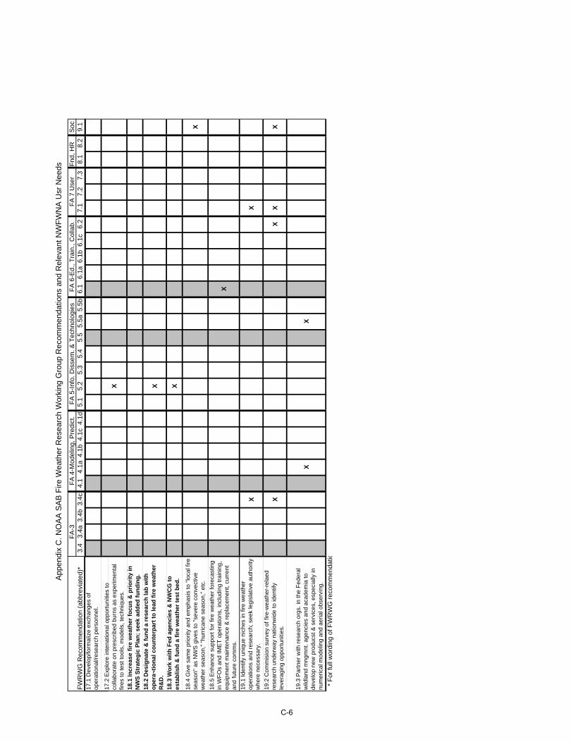
App
endi
x C
. NO
AA
SA
B F
ire W
eath
er R
esea
rch
Wor
king
Gro
up R
ecom
men
datio
ns a
nd R
elev
ant N
WF
WN
A U
sr N
eeds
FW
RW
G R
ecom
men
datio
n (a
bbre
viat
ed)*
17.1
Dev
elop
/form
aliz
e ex
chan
ges
of
oper
atio
nal/r
esea
rch
pers
onne
l.
17.2
Exp
lore
inte
natio
nal o
ppor
tuni
ties
to
colla
bora
te o
n pr
escr
ibed
bur
ns a
s ex
perim
enta
l fir
es to
test
tool
s, m
odel
s, te
chni
ques
.
18.1
Incr
ease
fir
e w
eath
er f
ocu
s &
pri
ori
ty in
N
WS
Str
ateg
ic P
lan
; se
ek a
dd
ed f
un
din
g.
18.2
Des
ign
ate
& f
un
d a
res
earc
h la
b w
ith
o
per
a¬ti
on
al c
ou
nte
rpar
t to
lead
fir
e w
eath
er
R&
D.
18.3
Wo
rk w
ith
Fed
ag
enci
es &
NW
CG
to
es
tab
lish
& f
un
d a
fir
e w
eath
er t
est
bed
.
18.4
Giv
e sa
me
prio
rity
and
emph
asis
to "
loca
l fire
se
ason
" as
NW
S g
ives
to "
seve
re c
onve
ctiv
e w
eath
er s
easo
n,"
"hur
rican
e se
ason
," e
tc.
18.5
Enh
ance
sup
port
for
fire
wea
ther
fore
cast
ing
in W
FO
s an
d IM
ET
ope
ratio
ns, i
nclu
ding
trai
ning
, eq
uipm
ent m
aint
enan
ce &
rep
lace
men
t, cu
rren
t an
d fu
ture
com
ms.
19.1
Iden
tify
uniq
ue n
iche
s in
fire
wea
ther
op
erat
ions
and
res
earc
h; s
eek
legi
slat
ive
auth
ority
w
here
nec
essa
ry.
19.2
Com
mis
ion
surv
ey o
f fire
-wea
ther
-rel
aed
rese
arch
und
erw
ay n
atio
nwid
e to
iden
tify
leve
ragi
ng o
ppor
tuni
ties.
19.3
Par
tner
with
res
earc
h or
gs. i
n th
e F
eder
al
wild
land
mng
mnt
. age
ncie
s an
d ac
adem
ia to
de
velo
p ne
w p
rodu
cst &
ser
vice
s, e
spec
ially
in
num
eric
al m
odel
ing
and
aeria
l obs
ervi
ng.
* F
or fu
ll w
ordi
ng o
f FW
RW
G r
ecom
men
datio
FA
-3F
A 4
-Mod
elin
g, P
redi
ct.
FA
5-I
nfo.
Dis
sem
. & T
echn
olog
ies
FA
6-E
d., T
rain
., C
olla
b.F
A 7
Use
rF
nd, H
RS
oc3.
43.
4a3.
4b3.
4c4.
14.
1a4.
1b4.
1c4.
1d5.
15.
25.
35.
45.
55.
5a5.
5b6.
16.
1a6.
1b6.
1c6.
27.
17.
27.
38.
18.
29.
1
X X X
X
X
XX
XX
XX
XX
C-6
Appendix D
Correlation of Current and In Development Fire Weather Capabilities
with NWFWNA User Needs

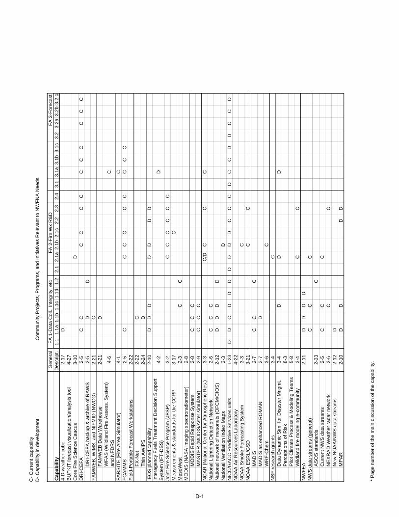
C-
Cur
rent
cap
abili
tyD
- C
apab
ility
in d
evel
opm
ent
Com
mun
ity P
roje
cts,
Pro
gram
s, a
nd In
itiat
ives
Rel
evan
t to
NW
FN
A N
eeds
Gen
eral
FA
2-F
ire W
x R
&D
FA
3-F
orec
ast
Cap
abili
tyD
escr
ipt.
1.1
1.1a
1.1b
1.1c
1.1d
1.2
2.1
2.1a
2.1b
2.1c
2.2
2.3
2.4
3.1
3.1a
3.1b
3.1c
3.2
3.2a
3.2b
3.2.
c4-
D w
eath
er c
ube
2-17
DB
UF
KIT
fore
cast
vis
ualiz
atio
n/an
alys
is to
ol4-
27C
ore
Fire
Sci
ence
Cau
cus
3-10
DD
RI-
CE
FA
2-5
CC
CC
CC
CC
CC
CC
DR
I-C
EF
A b
acku
p &
arc
hive
of R
AW
S2-
5D
DF
AM
WE
B, W
IMS
, and
NIF
MID
(N
WC
G)
2-21
CF
AM
WE
B D
ata
War
ehou
se2-
21D
WF
AS
(W
ildla
nd F
ire A
sses
s. S
yste
m)
and
NF
DR
S4-
6C
FA
RS
ITE
(F
ire A
rea
Sim
ulat
or)
4-1
CF
CA
MM
S2-
5C
CC
CC
CC
CC
Fie
ld-P
orta
ble
For
ecas
t Wor
ksta
tions
2-22
FX
-Net
2-22
CT
hin
AW
IPS
2-24
DIE
OS
pla
nned
cap
abili
ty2-
10D
DD
DD
DD
4-2
D
Join
t Fire
Sci
ence
Pro
gram
(JF
SP
)3-
2C
CC
CC
C3-
17C
Mes
oWes
t2-
3C
CM
OD
IS (
NA
SA
imag
ing
spec
tror
adio
met
er)
2-8
MO
DIS
Rap
id R
espo
nse
Sys
tem
2-8
CC
CM
AS
TE
R (
MO
DIS
/Ast
er s
imul
ator
)2-
9C
CC
NC
AR
(N
atio
nal C
ente
r fo
r A
tmos
pher
ic R
es.)
3-3
C/D
CC
CN
atio
nal L
ight
ning
Det
ectio
n N
etw
ork
2-6
CC
CN
atio
nal n
etw
ork
of m
eson
ets
(OF
CM
/CIO
S)
2-12
DD
DD
Nat
iona
l Ven
tilat
ion
Inde
x M
aps
3-3
DN
ICC
/GA
CC
Pre
dict
ive
Ser
vice
s un
its1-
23D
DC
DD
DD
DD
DC
CC
DC
CD
DC
CD
NO
AA
Air
Res
ourc
es L
abor
ator
y 4-
22N
OA
A S
mok
e F
orec
astin
g S
yste
m3-
3C
NO
AA
ES
RL/
GS
D3-
21C
CM
AD
IS
2-7
CC
CM
AD
IS a
s en
hanc
ed R
OM
AN
2-7
DW
RF
-Che
m
3-6
CN
SF
res
earc
h gr
ants
3-4
CD
ata
Dyn
amic
Sim
. for
Dis
aste
r M
ngm
t.3-
4D
DD
Per
cept
ions
of R
isk
8-3
Pilo
t Clim
ate
Pro
cess
& M
odel
ing
Tea
ms
5-8
Wild
land
fire
mod
elin
g e-
com
mun
ity3-
4C
CN
WF
EA
2-11
DD
DD
NW
S d
ata
stre
ams
(gen
eral
)C
CC
AS
OS
sta
ndar
ds2-
33C
Cur
rent
NW
S d
ata
stre
ams
2-5
CC
CN
EX
RA
D W
eath
er r
adar
net
wor
k2-
6C
CN
ew N
OA
A/N
WS
dat
a st
ream
s2-
12D
MP
AR
2-10
DD
DD
FA
1-D
ata
Col
l., In
tegr
ity, e
tc
Mea
sure
men
ts &
sta
ndar
ds fo
r th
e C
CR
P
Inte
rage
ncy
Fue
ls T
reat
men
t Dec
isio
n S
uppo
rt
Sys
tem
(IF
T-D
SS
)
* P
age
num
ber
of th
e m
ain
disc
ussi
on o
f the
cap
abili
ty.
D-1
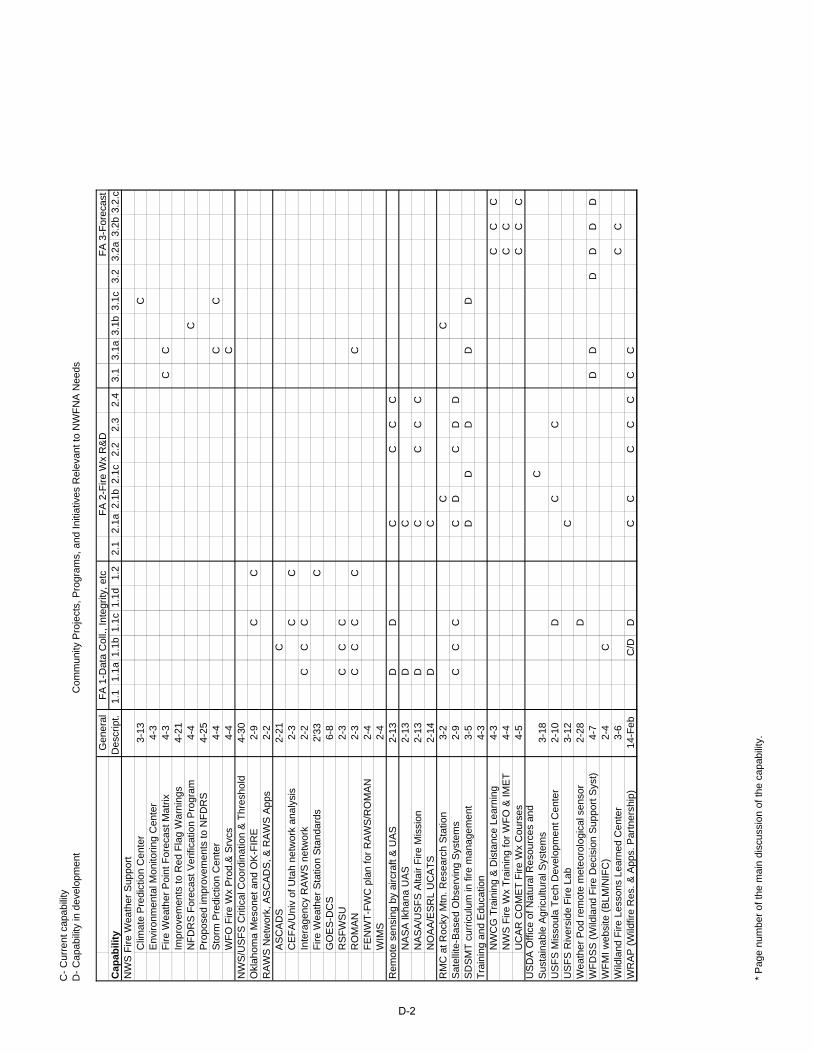
C-
Cur
rent
cap
abili
tyD
- C
apab
ility
in d
evel
opm
ent
Com
mun
ity P
roje
cts,
Pro
gram
s, a
nd In
itiat
ives
Rel
evan
t to
NW
FN
A N
eeds
Gen
eral
FA
2-F
ire W
x R
&D
FA
3-F
orec
ast
Cap
abili
tyD
escr
ipt.
1.1
1.1a
1.1b
1.1c
1.1d
1.2
2.1
2.1a
2.1b
2.1c
2.2
2.3
2.4
3.1
3.1a
3.1b
3.1c
3.2
3.2a
3.2b
3.2.
cF
A 1
-Dat
a C
oll.,
Inte
grity
, etc
NW
S F
ire W
eath
er S
uppo
rtC
limat
e P
redi
ctio
n C
ente
r3-
13C
Env
ironm
enta
l Mon
itorin
g C
ente
r4-
3F
ire W
eath
er P
oint
For
ecas
t Mat
rix4-
3C
CIm
prov
emen
ts to
Red
Fla
g W
arni
ngs
4-21
N
FD
RS
For
ecas
t Ver
ifica
tion
Pro
gram
4-4
CP
ropo
sed
impr
ovem
ents
to N
FD
RS
4-25
Sto
rm P
redi
ctio
n C
ente
r4-
4C
CW
FO
Fire
Wx
Pro
d.&
Srv
cs4-
4C
NW
S/U
SF
S C
ritic
al C
oord
inat
ion
& T
hres
hold
4-30
Okl
ahom
a M
eson
et a
nd O
K-F
IRE
2-9
CC
RA
WS
Net
wor
k, A
SC
AD
S, &
RA
WS
App
s2-
2A
SC
AD
S2-
21C
CE
FA
/Uni
v of
Uta
h ne
twor
k an
alys
is2-
3C
CIn
tera
genc
y R
AW
S n
etw
ork
2-2
CC
CF
ire W
eath
er S
tatio
n S
tand
ards
2'33
CG
OE
S-D
CS
6-8
RS
FW
SU
2-3
CC
CR
OM
AN
2-3
CC
CC
CF
EN
WT
-FW
C p
lan
for
RA
WS
/RO
MA
N2-
4W
IMS
2-4
Rem
ote
sens
ing
by a
ircra
ft &
UA
S2-
13D
DC
CC
CN
AS
A Ik
hana
UA
S2-
13D
CN
AS
A/U
SF
S A
ltair
Fire
Mis
sion
2-13
DC
CC
CN
OA
A/E
SR
L U
CA
TS
2-14
DC
RM
C a
t Roc
ky M
tn. R
esea
rch
Sta
tion
3-2
CC
Sat
ellit
e-B
ased
Obs
ervi
ng S
yste
ms
2-9
CC
CC
DC
DD
SD
SM
T c
urric
ulum
in fi
re m
anag
emen
t3-
5D
DD
DD
Tra
inin
g an
d E
duca
tion
4-3
NW
CG
Tra
inin
g &
Dis
tanc
e Le
arni
ng4-
3C
CC
NW
S F
ire W
x T
rain
ing
for
WF
O &
IME
T4-
4C
CU
CA
R C
OM
ET
Fire
Wx
Cou
rses
4-5
CC
C
3-18
C
US
FS
Mis
soul
a T
ech
Dev
elop
men
t Cen
ter
2-10
DC
CU
SF
S R
iver
side
Fire
Lab
3-12
CW
eath
er P
od r
emot
e m
eteo
rolo
gica
l sen
sor
2-28
DW
FD
SS
(W
ildla
nd F
ire D
ecis
ion
Sup
port
Sys
t)4-
7D
DD
DD
DW
FM
I web
site
(B
LM/N
IFC
)2-
4C
Wild
land
Fire
Les
sons
Lea
rned
Cen
ter
3-6
CC
WR
AP
(W
ildfir
e R
es. &
App
s. P
artn
ersh
ip)
14-F
ebC
/DD
CC
CC
CC
C
US
DA
Offi
ce o
f Nat
ural
Res
ourc
es a
nd
Sus
tain
able
Agr
icul
tura
l Sys
tem
s
* P
age
num
ber
of th
e m
ain
disc
ussi
on o
f the
cap
abili
ty.
D-2

C-
Cur
rent
cap
abili
tyD
- C
apab
ility
in d
evel
opm
ent
Com
mun
ity P
roje
cts,
Pro
gram
s, a
nd In
itiat
ives
Rel
evan
t to
NW
FN
A N
eeds
Gen
eral
Cap
abili
tyD
escr
ipt.
4-D
wea
ther
cub
e2-
17B
UF
KIT
fore
cast
vis
ualiz
atio
n/an
alys
is to
ol4-
27C
ore
Fire
Sci
ence
Cau
cus
3-10
DR
I-C
EF
A2-
5D
RI-
CE
FA
bac
kup
& a
rchi
ve o
f RA
WS
2-5
FA
MW
EB
, WIM
S, a
nd N
IFM
ID (
NW
CG
)2-
21F
AM
WE
B D
ata
War
ehou
se2-
21W
FA
S (
Wild
land
Fire
Ass
ess.
Sys
tem
) an
d N
FD
RS
4-6
FA
RS
ITE
(F
ire A
rea
Sim
ulat
or)
4-1
FC
AM
MS
2-5
Fie
ld-P
orta
ble
For
ecas
t Wor
ksta
tions
2-22
FX
-Net
2-22
Thi
n A
WIP
S2-
24IE
OS
pla
nned
cap
abili
ty2-
10
4-2
Join
t Fire
Sci
ence
Pro
gram
(JF
SP
)3-
23-
17M
esoW
est
2-3
MO
DIS
(N
AS
A im
agin
g sp
ectr
orad
iom
eter
)2-
8M
OD
IS R
apid
Res
pons
e S
yste
m2-
8M
AS
TE
R (
MO
DIS
/Ast
er s
imul
ator
)2-
9N
CA
R (
Nat
iona
l Cen
ter
for
Atm
osph
eric
Res
.)3-
3N
atio
nal L
ight
ning
Det
ectio
n N
etw
ork
2-6
Nat
iona
l net
wor
k of
mes
onet
s (O
FC
M/C
IOS
)2-
12N
atio
nal V
entil
atio
n In
dex
Map
s3-
3N
ICC
/GA
CC
Pre
dict
ive
Ser
vice
s un
its1-
23N
OA
A A
ir R
esou
rces
Lab
orat
ory
4-22
NO
AA
Sm
oke
For
ecas
ting
Sys
tem
3-3
NO
AA
ES
RL/
GS
D3-
21M
AD
IS
2-7
MA
DIS
as
enha
nced
RO
MA
N2-
7W
RF
-Che
m
3-6
NS
F r
esea
rch
gran
ts3-
4D
ata
Dyn
amic
Sim
. for
Dis
aste
r M
ngm
t.3-
4P
erce
ptio
ns o
f Ris
k8-
3P
ilot C
limat
e P
roce
ss &
Mod
elin
g T
eam
s5-
8W
ildla
nd fi
re m
odel
ing
e-co
mm
unity
3-4
NW
FE
A2-
11N
WS
dat
a st
ream
s (g
ener
al)
AS
OS
sta
ndar
ds2-
33C
urre
nt N
WS
dat
a st
ream
s2-
5N
EX
RA
D W
eath
er r
adar
net
wor
k2-
6N
ew N
OA
A/N
WS
dat
a st
ream
s2-
12M
PA
R2-
10
Mea
sure
men
ts &
sta
ndar
ds fo
r th
e C
CR
P
Inte
rage
ncy
Fue
ls T
reat
men
t Dec
isio
n S
uppo
rt
Sys
tem
(IF
T-D
SS
)
Pro
duct
s &
Ser
vice
sF
A 4
-Mod
elin
g, P
redi
ct.
FA
5-I
nfo.
Dis
sem
. & T
echn
olog
ies
3.3
3.3a
3.3b
3.3c
3.3d
3.3e
3.3f
3.3g
3.4
3.4a
3.4b
3.4c
4.1
4.1a
4.1b
4.1c
4.1d
5.1
5.2
5.3
5.4
5.5
5.5a
5.5b
C
CC
CC
CC
CC
CC
CC
CC
CC
CC
CC
DD
DD
DD
DD
DD
DC
/DD
DD
DD
C DD
DD
DC
CD
DC
CD
DD
DD
DD
DD
DC
CD
CD
CC C
DD
DD
DD
D
D
C CC
DD
DD
D
* P
age
num
ber
of th
e m
ain
disc
ussi
on o
f the
cap
abili
ty.
D-3
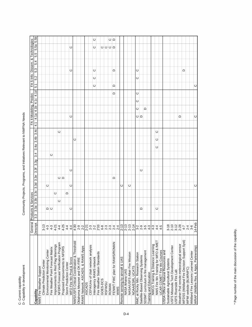
C-
Cur
rent
cap
abili
tyD
- C
apab
ility
in d
evel
opm
ent
Com
mun
ity P
roje
cts,
Pro
gram
s, a
nd In
itiat
ives
Rel
evan
t to
NW
FN
A N
eeds
Gen
eral
Cap
abili
tyD
escr
ipt.
NW
S F
ire W
eath
er S
uppo
rtC
limat
e P
redi
ctio
n C
ente
r3-
13E
nviro
nmen
tal M
onito
ring
Cen
ter
4-3
Fire
Wea
ther
Poi
nt F
orec
ast M
atrix
4-3
Impr
ovem
ents
to R
ed F
lag
War
ning
s4-
21
NF
DR
S F
orec
ast V
erifi
catio
n P
rogr
am4-
4P
ropo
sed
impr
ovem
ents
to N
FD
RS
4-25
Sto
rm P
redi
ctio
n C
ente
r4-
4W
FO
Fire
Wx
Pro
d.&
Srv
cs4-
4N
WS
/US
FS
Crit
ical
Coo
rdin
atio
n &
Thr
esho
ld4-
30O
klah
oma
Mes
onet
and
OK
-FIR
E2-
9R
AW
S N
etw
ork,
AS
CA
DS
, & R
AW
S A
pps
2-2
AS
CA
DS
2-21
CE
FA
/Uni
v of
Uta
h ne
twor
k an
alys
is2-
3In
tera
genc
y R
AW
S n
etw
ork
2-2
Fire
Wea
ther
Sta
tion
Sta
ndar
ds2'
33G
OE
S-D
CS
6-8
RS
FW
SU
2-3
RO
MA
N2-
3F
EN
WT
-FW
C p
lan
for
RA
WS
/RO
MA
N2-
4W
IMS
2-4
Rem
ote
sens
ing
by a
ircra
ft &
UA
S2-
13N
AS
A Ik
hana
UA
S2-
13N
AS
A/U
SF
S A
ltair
Fire
Mis
sion
2-13
NO
AA
/ES
RL
UC
AT
S2-
14R
MC
at R
ocky
Mtn
. Res
earc
h S
tatio
n3-
2S
atel
lite-
Bas
ed O
bser
ving
Sys
tem
s2-
9S
DS
MT
cur
ricul
um in
fire
man
agem
ent
3-5
Tra
inin
g an
d E
duca
tion
4-3
NW
CG
Tra
inin
g &
Dis
tanc
e Le
arni
ng4-
3N
WS
Fire
Wx
Tra
inin
g fo
r W
FO
& IM
ET
4-4
UC
AR
CO
ME
T F
ire W
x C
ours
es4-
5
3-18
US
FS
Mis
soul
a T
ech
Dev
elop
men
t Cen
ter
2-10
US
FS
Riv
ersi
de F
ire L
ab3-
12W
eath
er P
od r
emot
e m
eteo
rolo
gica
l sen
sor
2-28
WF
DS
S (
Wild
land
Fire
Dec
isio
n S
uppo
rt S
yst)
4-7
WF
MI w
ebsi
te (
BLM
/NIF
C)
2-4
Wild
land
Fire
Les
sons
Lea
rned
Cen
ter
3-6
WR
AP
(W
ildfir
e R
es. &
App
s. P
artn
ersh
ip)
14-F
eb
US
DA
Offi
ce o
f Nat
ural
Res
ourc
es a
nd
Sus
tain
able
Agr
icul
tura
l Sys
tem
s
Pro
duct
s &
Ser
vice
sF
A 4
-Mod
elin
g, P
redi
ct.
FA
5-I
nfo.
Dis
sem
. & T
echn
olog
ies
3.3
3.3a
3.3b
3.3c
3.3d
3.3e
3.3f
3.3g
3.4
3.4a
3.4b
3.4c
4.1
4.1a
4.1b
4.1c
4.1d
5.1
5.2
5.3
5.4
5.5
5.5a
5.5b
DC
CC
CC
CC
DD
CC
CC
CC
C
CC
CC
C
C C CC
DD
DD
DD
C C
CC
CC
CC
DC
DD
CC
CC
DD
CC
C
* P
age
num
ber
of th
e m
ain
disc
ussi
on o
f the
cap
abili
ty.
D-4
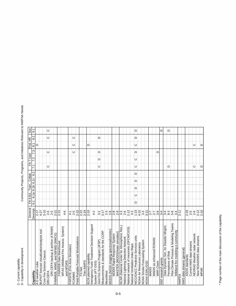
C-
Cur
rent
cap
abili
tyD
- C
apab
ility
in d
evel
opm
ent
Com
mun
ity P
roje
cts,
Pro
gram
s, a
nd In
itiat
ives
Rel
evan
t to
NW
FN
A N
eeds
Gen
eral
Cap
abili
tyD
escr
ipt.
4-D
wea
ther
cub
e2-
17B
UF
KIT
fore
cast
vis
ualiz
atio
n/an
alys
is to
ol4-
27C
ore
Fire
Sci
ence
Cau
cus
3-10
DR
I-C
EF
A2-
5D
RI-
CE
FA
bac
kup
& a
rchi
ve o
f RA
WS
2-5
FA
MW
EB
, WIM
S, a
nd N
IFM
ID (
NW
CG
)2-
21F
AM
WE
B D
ata
War
ehou
se2-
21W
FA
S (
Wild
land
Fire
Ass
ess.
Sys
tem
) an
d N
FD
RS
4-6
FA
RS
ITE
(F
ire A
rea
Sim
ulat
or)
4-1
FC
AM
MS
2-5
Fie
ld-P
orta
ble
For
ecas
t Wor
ksta
tions
2-22
FX
-Net
2-22
Thi
n A
WIP
S2-
24IE
OS
pla
nned
cap
abili
ty2-
10
4-2
Join
t Fire
Sci
ence
Pro
gram
(JF
SP
)3-
23-
17M
esoW
est
2-3
MO
DIS
(N
AS
A im
agin
g sp
ectr
orad
iom
eter
)2-
8M
OD
IS R
apid
Res
pons
e S
yste
m2-
8M
AS
TE
R (
MO
DIS
/Ast
er s
imul
ator
)2-
9N
CA
R (
Nat
iona
l Cen
ter
for
Atm
osph
eric
Res
.)3-
3N
atio
nal L
ight
ning
Det
ectio
n N
etw
ork
2-6
Nat
iona
l net
wor
k of
mes
onet
s (O
FC
M/C
IOS
)2-
12N
atio
nal V
entil
atio
n In
dex
Map
s3-
3N
ICC
/GA
CC
Pre
dict
ive
Ser
vice
s un
its1-
23N
OA
A A
ir R
esou
rces
Lab
orat
ory
4-22
NO
AA
Sm
oke
For
ecas
ting
Sys
tem
3-3
NO
AA
ES
RL/
GS
D3-
21M
AD
IS
2-7
MA
DIS
as
enha
nced
RO
MA
N2-
7W
RF
-Che
m
3-6
NS
F r
esea
rch
gran
ts3-
4D
ata
Dyn
amic
Sim
. for
Dis
aste
r M
ngm
t.3-
4P
erce
ptio
ns o
f Ris
k8-
3P
ilot C
limat
e P
roce
ss &
Mod
elin
g T
eam
s5-
8W
ildla
nd fi
re m
odel
ing
e-co
mm
unity
3-4
NW
FE
A2-
11N
WS
dat
a st
ream
s (g
ener
al)
AS
OS
sta
ndar
ds2-
33C
urre
nt N
WS
dat
a st
ream
s2-
5N
EX
RA
D W
eath
er r
adar
net
wor
k2-
6N
ew N
OA
A/N
WS
dat
a st
ream
s2-
12M
PA
R2-
10
Mea
sure
men
ts &
sta
ndar
ds fo
r th
e C
CR
P
Inte
rage
ncy
Fue
ls T
reat
men
t Dec
isio
n S
uppo
rt
Sys
tem
(IF
T-D
SS
)
FA
6-E
d., T
rain
., C
olla
b.F
A 7
Use
rF
nd, H
RS
oc6.
16.
1a6.
1b6.
1c6.
27.
17.
27.
38.
18.
29.
1D
CC
CC
CC
C
D
CD
DD
DC
DD
DC
CD
CD
D
DD
DD
CC
DD
* P
age
num
ber
of th
e m
ain
disc
ussi
on o
f the
cap
abili
ty.
D-5
C-
Cur
rent
cap
abili
tyD
- C
apab
ility
in d
evel
opm
ent
Com
mun
ity P
roje
cts,
Pro
gram
s, a
nd In
itiat
ives
Rel
evan
t to
NW
FN
A N
eeds
Gen
eral
Cap
abili
tyD
escr
ipt.
NW
S F
ire W
eath
er S
uppo
rtC
limat
e P
redi
ctio
n C
ente
r3-
13E
nviro
nmen
tal M
onito
ring
Cen
ter
4-3
Fire
Wea
ther
Poi
nt F
orec
ast M
atrix
4-3
Impr
ovem
ents
to R
ed F
lag
War
ning
s4-
21
NF
DR
S F
orec
ast V
erifi
catio
n P
rogr
am4-
4P
ropo
sed
impr
ovem
ents
to N
FD
RS
4-25
Sto
rm P
redi
ctio
n C
ente
r4-
4W
FO
Fire
Wx
Pro
d.&
Srv
cs4-
4N
WS
/US
FS
Crit
ical
Coo
rdin
atio
n &
Thr
esho
ld4-
30O
klah
oma
Mes
onet
and
OK
-FIR
E2-
9R
AW
S N
etw
ork,
AS
CA
DS
, & R
AW
S A
pps
2-2
AS
CA
DS
2-21
CE
FA
/Uni
v of
Uta
h ne
twor
k an
alys
is2-
3In
tera
genc
y R
AW
S n
etw
ork
2-2
Fire
Wea
ther
Sta
tion
Sta
ndar
ds2'
33G
OE
S-D
CS
6-8
RS
FW
SU
2-3
RO
MA
N2-
3F
EN
WT
-FW
C p
lan
for
RA
WS
/RO
MA
N2-
4W
IMS
2-4
Rem
ote
sens
ing
by a
ircra
ft &
UA
S2-
13N
AS
A Ik
hana
UA
S2-
13N
AS
A/U
SF
S A
ltair
Fire
Mis
sion
2-13
NO
AA
/ES
RL
UC
AT
S2-
14R
MC
at R
ocky
Mtn
. Res
earc
h S
tatio
n3-
2S
atel
lite-
Bas
ed O
bser
ving
Sys
tem
s2-
9S
DS
MT
cur
ricul
um in
fire
man
agem
ent
3-5
Tra
inin
g an
d E
duca
tion
4-3
NW
CG
Tra
inin
g &
Dis
tanc
e Le
arni
ng4-
3N
WS
Fire
Wx
Tra
inin
g fo
r W
FO
& IM
ET
4-4
UC
AR
CO
ME
T F
ire W
x C
ours
es4-
5
3-18
US
FS
Mis
soul
a T
ech
Dev
elop
men
t Cen
ter
2-10
US
FS
Riv
ersi
de F
ire L
ab3-
12W
eath
er P
od r
emot
e m
eteo
rolo
gica
l sen
sor
2-28
WF
DS
S (
Wild
land
Fire
Dec
isio
n S
uppo
rt S
yst)
4-7
WF
MI w
ebsi
te (
BLM
/NIF
C)
2-4
Wild
land
Fire
Les
sons
Lea
rned
Cen
ter
3-6
WR
AP
(W
ildfir
e R
es. &
App
s. P
artn
ersh
ip)
14-F
eb
US
DA
Offi
ce o
f Nat
ural
Res
ourc
es a
nd
Sus
tain
able
Agr
icul
tura
l Sys
tem
s
FA
6-E
d., T
rain
., C
olla
b.F
A 7
Use
rF
nd, H
RS
oc6.
16.
1a6.
1b6.
1c6.
27.
17.
27.
38.
18.
29.
1
CC
CC
CC
DD
CC
CC
CC
CC
CC
CC
DD
D
CC
CC
CC
* P
age
num
ber
of th
e m
ain
disc
ussi
on o
f the
cap
abili
ty.
D-6