Embed Size (px)
Citation preview

Why is this project needed?
1
Why is this project needed, and what evidence CHAPTER 1 established these needs?
Chapter titles are framed as questions intended to focus the writing and to alert readers to judge whether the answers provided are adequate. For readers accustomed to earlier environmental documents, chapter 1 is equivalent to the “Purpose and Need for Action” section. Note: This EIS and its appendices contain information that differs from or was not in the draft EIS. The changes respond to new information, public comment, advice from regulatory agencies, and corrections. For example, chapter 2 contains additional material that responds to public preference for more specific information on the alternatives. Chapter 3 contains information requested by the public and regulatory agencies about existing road and water-quality conditions, existing road maintenance and costs, and updates the biological assessment. Chapter 4 contains added material about sedimentation from roads, water quality, public and management access, economics, and updates discussions on bald eagles, northern spotted owls, and marbled murrelets. Additional tables provide more-specific information by subwatershed, and effects on aquatic conservation objectives and environmental justice were also added. Appendices 1 through 5 of the draft are now A through E. Appendices A through C have been modified to include additional or more-specific information requested by the public.
The Planning Area The area included in the Five Rivers Landscape Management Project lies within the Five Rivers-Lobster Creek fifth-field watershed of the Alsea River basin. The planning area is about 34 air miles southwest of Corvallis and 40 air miles northwest of Eugene, Oregon (map 1); it includes eight subwatersheds and covers about 37,000 acres. About 13% of the planning area is privately owned, and the rest is managed by the U.S. Forest Service. The Proposed Project The Five Rivers Landscape Management Project is a package of associated terrestrial and watershed restoration projects. They include commercially thinning plantations now less than 50 years old, decommissioning roads, placing large conifer trees--up to 36 inches in diameter at breast height--in streams, and planting conifers and hardwoods in riparian areas. A management study, designed to compare management strategies, is part of the proposal. The Problems To Be Addressed Based on available information, and direction from the Northwest Forest Plan (the Plan), previous Forest Supervisor Jim Furnish identified the following problems (USDA 1999):

Why is this project needed?
2
! Not enough is known for people to agree on a single approach to meet the goals of the
Northwest Forest Plan, partly a result of ineffective past monitoring strategies. Especially poorly known is how plantations, riparian zones, and roads can be efficiently managed together through time. Thus, he saw a need to speed learning by comparing a variety of strategies for achieving late-successional conditions and aquatic conservation.
! The shortage of late-successional habitat in the Pacific Northwest limits recovery of old-growth-dependent species such as the northern spotted owl and the marbled murrelet. Thus, he saw a need to speed development of late-successional habitat in late-successional and riparian reserves.
! The shortage of properly functioning aquatic habitat in the Oregon Coast Range limits recovery of cold-water species such as coho salmon. Thus, he saw a need to improve watershed function.
! The Northwest Forest Plan called for substantial timber production from the matrix lands, but murrelets are almost always found in surveyed mature forest on the Siuslaw matrix lands, which are then redesignated as late-successional reserves. Thus, he saw the need to simultaneously produce timber from plantations and meet late-successional objectives on matrix lands.
Evidence Used by the Forest Supervisor in Deciding to Address These Problems The record of decision (USDA, USDI 1994b) for the Northwest Forest Plan--based on physical, biological, and societal evidence provided in the Forest Ecosystem Management Assessment Team report (USDA, USDI, et al. 1993) and described in the Plan’s environmental impact statement (USDA, USDI 1994a)--is intended to provide for: # Healthy forest ecosystems, including protecting riparian areas and waters; # A suitable supply of timber and other forest products to help maintain local and regional
economies predictably over the long term; and # Adaptive management--described as a process of action-based planning, monitoring,
researching, evaluating, and adjusting--to improve future land management decisions. The Plan identified concern for northern spotted owls, marbled murrelets, and anadromous fish in the Oregon Coast Range Province (which includes the Siuslaw National Forest) because of its isolation and harvest history (chapters 3 and 4; p. 21). The record of decision, which amended the Siuslaw Forest Plan, allocated federal lands in the Five Rivers watershed into one or more of the following: # Late-successional reserve; # Riparian reserve; or # Matrix (lands not included in the other two allocations).
The Plan identified specific environmental conditions and appropriate commodities and amenities to be produced and maintained in each land allocation. It also outlined the rules and limits governing possible activities for achieving desired conditions in each allocation. The Assessment Report for Federal Lands in and Adjacent to the Oregon Coast Province (USDA 1995a) shows the planning area in the central interior block (block 6). The mature conifer stands

Why is this project needed?
3
in block 6 have been extensively clearcut, and few patches of functional late-successional forest remain. The central interior block once supported the largest unfragmented patches of late-successional forest in the Province. The Report recommends managing to accelerate successional development and to aggregate small patches into larger ones. The Report describes the in-stream fish habitat on federal lands throughout the Province as being in marginal to poor condition. It recommends specific actions to improve fish habitat on federal land by: # Stabilizing, decommissioning, or obliterating roads; # Restoring immediate habitat conditions by adding large wood to streams; and # Restoring long-term habitat by reestablishing natural riparian areas through actions such
as riparian planting. For needing to learn The need to learn, for individuals and society as a whole, is strongest when uncertainty exists about how events will unfold. The current extent and intensity of debate among managers, scientists, and citizens over outcomes of land-management strategies provide strong evidence that sufficient uncertainty exists among knowledgeable and concerned people to warrant investing in learning. Three examples contributing to this evidence supporting the proposed action are: # The current high density of Siuslaw Forest roads continues to fuel debate over their long-
term management, primarily related to the values associated with using and maintaining them versus their adverse effects on the aquatic and terrestrial environment.
# Debate also surrounds the question of whether the plantations will ever reach old-growth conditions, with or without thinning and underplanting.
# Another hotly debated issue is whether anything that people do to improve streams for salmon and steelhead is likely to increase the population faster than just letting Mother Nature take over.
The diversity of views held by the debaters can be represented in a limited number of pathways that can be compared, to illuminate the debate and lead to improved practices. For needing late-successional habitat Late-successional reserves were designed into the Northwest Forest Plan to protect and enhance these forest ecosystems, which are required habitat for many species. Riparian reserve objectives include protecting and enhancing habitat for terrestrial plants and animals, as well as providing connectivity corridors between late-successional reserves. The Late Successional Reserve Assessment, Oregon Coast Province Southern Portion (USDA, USDI 1997), identified the following landscape changes in the Five Rivers watershed: # The dominant patch size has decreased from jumbo patches (larger than 10,000 acres) to
medium-sized patches (100 to 1,000 acres).

Why is this project needed?
4
# The number of medium-sized, mature patches has increased by six times over that found
in the mid-1900s. # The largest percentage reduction in late-seral vegetation on federal lands in the Province is
in the central interior Alsea disturbance block, which includes the Five Rivers watershed. The Lobster-Five Rivers Watershed Analysis (USDA 1997a) reported that: # Most of the subwatersheds contain less than 40% mature forest. # Fewer than 15% of the mature forest stands function as interior forest habitat. # Coarse woody debris in plantations is less than one-third of the amounts found in natural
stands of similar age. # More than 40% of the planning area is in plantations. # Plantations were intended to be and have been managed for intensive wood-fiber
production. For needing to restore watershed health The Plan’s Aquatic Conservation Strategy is intended to restore and maintain the health of watersheds and the aquatic ecosystems they contain. The Lobster-Five Rivers watershed analysis identified the following adverse effects on the watershed: # Concentrations of fine sediments are higher than historically, impairing the function of
riffles, pools, and winter rearing areas. # The amount of large wood in streams is generally low, less than 80 pieces per mile. # Forest and county roads inhibit large wood transport. # The water quality of four streams (Green River, Crab Creek, Buck Creek, and Five
Rivers) are considered impaired because they exceed the 64-degree temperature standard established by the Oregon Department of Environmental Quality.
For needing commodities Based on societal needs outlined in the Forest Ecosystem Management Assessment Team’s (FEMAT) report (USDA, USDI, et al. 1993), the Plan designates producing timber and other products to be important objectives for the matrix lands. The standards and guides for these lands are designed to provide important ecological functions and to maintain structural components like logs, snags, and large green trees. Outside of riparian reserves, the matrix lands also provide opportunities to maintain some early-successional habitat in the watershed.

What alternatives were developed?
5
What alternatives were developed CHAPTER 2 to meet the identified needs?
In chapter 2, we describe three alternative proposals for resolving the problems and meeting the needs identified in chapter 1; it is equivalent to the traditional section, “Alternatives Including the Proposed Action”. (The “we” in the previous sentence and throughout the document is our interdisciplinary team). We designed these alternatives based in part on priorities and recommendations identified in the Forest’s late-successional reserve assessment for LSR RO268 and the Lobster-Five Rivers watershed analysis. We also evaluated the project activities--commercial thinning, in-stream and riparian restoration, and road decommissioning--and their placement, based on the histories and current conditions of those sites. For example, we collected information about past harvesting practices, such as clearcutting trees, broadcast-burning harvested areas, and felling all of the snags; silvicultural practices, such as planting a single tree species at 400 trees per acre; and the age and current attributes of managed stands for the sites where actions are proposed. This collection of site information helped us to identify stands suitable for or in need of thinning and other actions--such as underplanting, adding coarse wood, and creating snags--to help maintain stand health or accelerate developing late-successional characteristics. We evaluated stream characteristics--such as gradient, connectivity to flood plains, in-stream large wood, shading, and numbers of conifers in the riparian zone--to help identify areas for restoration. Actions for restoring aquatic habitat include placing large wood in streams to improve hydrologic function and planting trees in the riparian zone to increase future shade and large-wood sources. Several factors helped us identify roads for decommissioning: the need to reduce adverse effects to fish habitat and water quality by reducing reliance on valley-bottom and mid-slope roads, maintaining future access to managed stands, providing public access, and reducing road maintenance or rebuilding costs because funds for maintaining the current road system are lacking.
In addition to meeting the identified needs, the range of alternatives considered reflects concerns raised during public scoping for this project; public comments on the draft EIS (appendix D); and public involvement with recent Waldport Ranger District projects, such as Big Blue and Drift Home, including resolution of appeals or concerns raised during monitoring of District projects. The merits (including the effectiveness) of commercial thinning to accelerate developing late-successional forests is a common debate affecting projects with this activity. Part of this debate includes reopening closed or decommissioned roads and building new temporary roads to support commercial thinning operations. One respondent continues to question why the Siuslaw National Forest does not develop timber sales that harvest mature timber from the remaining matrix lands. Industrial timber landowners and rural residents are concerned about maintaining legal access to their lands, as well as convenient routes to multiple communities under all conditions. Also, the need to close or decommission roads as the appropriate response to declining road maintenance funds or to restore watershed health is questioned by some Forest users and encouraged by others, including some regulatory agencies.
What alternatives were developed?
6
Alternatives Considered But Eliminated from Detailed Study With the uncertainty about how commercially thinned managed stands will function as late-successional forest habitat in the long term, researchers have developed and implemented scientific studies, such as how stands respond to commercial thinning and underplanting. Although many studies, either completed or in progress, are intended to evaluate the response of individual stands to a particular treatment, no studies in the Oregon Coast Range currently evaluate the outcomes of different treatments at the landscape scale. Pacific Northwest Research Station scientists, in cooperation with our interdisciplinary team (Team), have designed a management study to evaluate the response of the landscape to different approaches. Alternatives 1 and 2 were developed to include this management study. The Team considered an alternative without a management study. Although monitoring is intended as part of all management actions, past projects and monitoring were planned and conducted at scales more conducive for learning and adapting at a site-specific scale. Although lessons learned at this scale have been applied to later projects, data could not be extrapolated with confidence at the landscape scale. As with earlier projects, proposed actions without the study would meet some Plan objectives, but they would not be likely to produce the new knowledge at the landscape scale needed by resource managers to meet the need identified for learning. The Forest Supervisor therefore directed the Team not to develop an action alternative without the management study. The commercial harvest of mature timber from matrix lands in the Five Rivers area has been proposed by several people from the public, private, and agency sectors. The Lobster-Five Rivers watershed analysis recognized and identified subwatersheds where commercial harvest of mature timber would be consistent with the Plan. Currently, 845 acres of mature timber in the Five Rivers Landscape Management Project are designated matrix. Preliminary evaluation of these stands and experience with similar stands in the watershed indicate that if they were surveyed for marbled murrelets, more than 90% are likely to be identified as occupied. Current standards require that occupied stands, along with all suitable habitat within a one-half mile radius, be designated as late-successional reserve. If any of the remaining matrix lands contained mature timber, the controversy associated with harvesting mature timber--along with required protection measures for other listed species and survey-and-manage species--would likely delay or prevent any proposed timber harvest if the lands were included in a landscape-scale project. Harvesting mature timber in matrix lands was therefore not fully developed in the alternatives. The Siuslaw Access and Travel Management Guide (USDA 1994) was developed in response to declining road maintenance funds. A key component of the guide was a mechanism to establish funding priorities and maintenance levels under which road maintenance funds would be expended. The guide presumed that projects, such as commercial thinning, would generate or provide sufficient funds to maintain roads required to access a given project. Although the guide identified roads on which appropriated road maintenance funds could be expended, it made no decisions about nor was it designed to determine the continued need for roads to be maintained with other funds. Late-successional reserve assessments and watershed analysis were developed to help identify resource management priorities and activities on the landscape. Because the

What alternatives were developed?
7
access and travel management guide was prepared before these documents were available, it does not reflect the resource needs identified by those documents. Therefore, an alternative to develop resource actions based solely on the location of the existing primary and secondary road system was not fully developed. Alternatives Considered in Detail
Based on public comments on the draft EIS, we made three modifications to Alternatives 1 and 2: the segment of road 32 identified for decommissioning will be maintained as an ATM road until a natural event causes it to fail or unless Lane County accepts a public road easement to maintain the road; road 3505--including the Summers Creek road segment (1.6 miles)--will be maintained under its current status as an ATM road, rather than decommissioned; and 5 miles of stream adjacent to private property in the Lower Buck and Upper Buck subwatersheds were added to the hydrologic restoration efforts. The Forest Supervisor and Team believe that, at this planning scale, these modifications are minor and do not constitute developing another alternative. Other numbers different from those in the draft EIS either respond to public comments asking for additional clarity or reflect minor corrections.
The action alternatives propose similar types of activities but represent different management approaches; thus, the same design criteria apply to both alternatives. Design criteria (appendix B) outline the practices to be used and their timing and duration when planned actions and activities are implemented. We believe that mitigation measures for all proposed actions are covered by the design criteria, with one exception. To mitigate for the absence of snags, a result of past actions, snags will be created by topping trees in natural stands adjacent to commercially thinned plantations. This mitigation measure is the only one added to the action alternatives or design criteria after they were developed. Alternative 1: Active landscape management with temporary roads (Forest Service’s Preferred Alternative) Actions included in this alternative are designed to address the problems identified by the Forest Supervisor. The actions incorporate the standards and guides established by the Siuslaw Forest Plan, as amended by the Northwest Forest Plan; the design criteria; and monitoring protocols outlined in appendix B. Selecting this alternative would result in the following management actions: To speed learning, the following actions from the Five Rivers Landscape Management Study Plan (appendix A) are proposed: ! Designate 12 management study areas as part of the learning design (maps 2 and 3); ! Install, monitor, and compare three different management pathways in the 12 study areas:
$ Passive management: Stands will not be thinned, and only some stream restoration will be implemented. Roads will be permanently closed (decommissioned).
$ Pulsed management: Stands will be thinned to very wide spacing and streams restored; treatments will be completed in one, short-term pulse. Roads will be closed, reversibly, for 20 to 30 years, followed by another management pulse.
$ Continuous management: Management actions will be distributed through time, and thinning and stream restoration will thus be less intense than with pulsed management. Roads will be opened and maintained more frequently.

What alternatives were developed?
8
To speed the development of late-successional habitat in late-successional and riparian reserves, the following actions are proposed:
Silvicultural treatments and associated actions ! Commercially thin about 2,670 acres of plantations in reserves including about 1,650
acres in riparian reserve (maps 2, 6, and appendix C-3); ! Reopen about 5.0 miles of system roads in reserves--including about 2.8 miles in riparian
reserve--and about 1.7 miles of system roads in matrix by repairing 14 road-failure sites (maps 3, 7, and appendix C-3);
! Temporarily reopen about 6.2 miles of existing operator spur roads in reserves--including about 3.4 miles in riparian reserve--and about 3.4 miles of existing operator spurs in matrix by removing vegetation and minor slides from 52 roads (maps 3, 7, and appendix C-3);
! Build about 0.9 miles of new temporary road in reserves--including about 0.3 miles in riparian reserve--and 0.1 miles in matrix (maps 3, 7);
! Create about 1,240 snags in natural stands adjacent to commercially thinned plantations, as mitigation for past harvest practices (appendix C-2);
! Develop future snags in thinned portions of plantations by inoculating about 6,500 trees with native fungi including 20% mitigation for past harvest practices (appendix C-2);
! Increase the coarse wood component in commercially thinned plantations in late-successional reserves by leaving about 25,000 plantation trees on the ground, to mitigate for past harvest practices (appendix C-2);
! Plant a mixture of shade-tolerant conifers and hardwoods on about 1,600 acres of existing plantations;
! Develop future snags in unthinned portions of plantations by inoculating about 4,200 trees with native fungi to enhance the snag component of late-successional reserve (appendix C-2);
! Precommercially thin about 2,032 acres of young plantations in reserves, through service contracts including about 1,250 acres in riparian reserve (map 6); and
! Maintain about 40 acres of existing meadows in early-seral condition to provide minimum diversity of seral conditions in late-successional reserve (map 2).
To improve watershed function, the following actions are proposed in addition to the silvicultural treatments:
System road actions ! Decommission about 49 miles of road including about 29.6 miles in riparian reserve
(maps 3, 7); ! Close about 76 miles of road to vehicular traffic including about 29.9 miles in riparian
reserve (maps 3, 7); Hydrologic function and water-quality actions ! Place about 1,050 large conifers (up to 36 inches in diameter at breast height) and root
wads along about 16 miles of stream on federal land and 7 miles of stream adjacent to private land (map 2);
! Plant about 200 acres of shade-tolerant conifers and various hardwoods along alder- or meadow-dominated riparian areas (map 2);
What alternatives were developed?
9
Road special-use permit ! Issue a special-use permit for building and maintaining a 0.5-mile road on or near a ridge
top--including about 0.3 mile in riparian reserve--to access private land as mitigation for loss of access by decommissioning a 4.8-mile valley-bottom road that is completely in riparian reserve (maps 3, 7).
Note: The decommissioning mileage used here reflects maintaining road 3505--including the Summers Creek road segment (1.6 miles)--as an ATM road. The mileages for decommissioning under Alternatives 1 and 2 in the draft EIS are incorrect because they failed to include the mileage for the Summers Creek segment.
To provide timber and other products and amenities in matrix lands, the following actions are proposed: ! Commercially thin about 560 acres of plantations (maps 2, 6, and appendix C-3); ! Precommercially thin about 334 acres of plantations (map 6); ! Maintain about 11 acres of existing meadows in early-seral condition (map 2); ! Create and maintain 14 acres of early-seral habitat in matrix portions of commercially
thinned plantations to mitigate the loss of 14 acres of existing meadow habitat from riparian planting (map 2).
Most actions would be completed in 10 to 15 years, with most commercial timber-sale contracts awarded in the first 5 years. The actions of Alternative 1 are summarized by subwatershed in Table 1. Refer to appendix C for specific plantation information about silvicultural prescriptions and commercial thinning.

What alternatives were developed?
10
Table 1. Description of Alternative 1 by subwatershed
Actions Cascade Crab Green River
Lower Buck
Lower Five
Middle Five
Upper Buck
Upper Five
Commercial thinning (acres) Total commercial thin Commercial thin, skyline Commercial thin, helicopter Comm. thin inside study Comm. thin outside study
211 163
48 125
86
747 702
45 369 378
469 406
63 257 212
472 459
13 150 322
211 211
0 126
85
233 233
0 71
162
367 334
33 104 263
520 438
82 0
520
System (classified) roads (miles) Reopen roads Close roads Decommission roads Temporary (unclassified) Roads (miles) New roads Reopen roads
0 0.50
13.50
0.08 0.25
2.01 16.70
5.70
0.20 1.06
0.89 7.90
15.80
0.07 1.11
0.95 11.30
1.30
0.17 2.09
2.12 11.20
2.80
0.15 0.40
0 8.90 1.40
0.07 1.56
0.76 7.70 3.30
0 1.50
0 11.80
5.30
0.28 1.62
Hydrologic function and water quality Large wood in streams (miles): Federal Private Trees required for large wood less than or equal to 36 inches in diameter at breast height (number) Riparian planting (acres)
0 0
0 2
3.0 2.0
233 26
5.9 0
201 56
0.1 3.7
234 0
0 0
0 34
0.6 0
10 16
1.9 1.3
163 18
4.6 0
209 48
Snag and coarse wood creation (trees) Mature tree topping Trees inoculated in commercial thinning, including 20% mitigation Trees inoculated in unthinned portion of plantations (enhancement) Trees felled for coarse wood
148
359
192 4,260
225
1,569
739 4,255
329
798
958 4,530
141
991
804 3,620
63
443
260 1,055
69
489
275 1,745
112
773
316 3,000
156
1,092
706 2,600
Other actions Precommercial thinning area (acres) Area maintained in early-seral condition (acres) Stand underplanting (acres) New road building to maintain private-land access (miles)
97
5.7 135
0
391
20.7 435
0
141
5.2 359
0.5
277
4.0 160
0
460
0 63
0
194
29.9 96
0
162
0 194
0
644
0 146
0

What alternatives were developed?
11
See Map 2

What alternatives were developed?
12
See Map 2

What alternatives were developed?
13
See Map 3

What alternatives were developed?
14
See Map 3

What alternatives were developed?
15
Alternative 2: Active landscape management without temporary or repaired roads Actions under Alternative 2 are designed to meet the same needs as for Alternative 1, and they incorporate the same standards, guides, design criteria, and monitoring. Management actions would be the same for both alternatives, except that Alternative 2 would not include building temporary roads in plantations or repairing roads accessing plantations or roads closed by slides or washouts. About 15 miles of roads behind slides and washouts would be abandoned. As a result, five plantations totaling 109 acres would not be thinned because helicopter logging would not be feasible. In addition, snags and coarse wood would not be created in these five stands. The affected stands are in the Crab (stands 305 and 323), Lower Buck (250), Lower Five (122), and Upper Buck (425) subwatersheds. The Forest Supervisor asked the Team to develop this alternative so that citizens who want no new temporary roads built and no failed roads reopened could compare effects of the two alternatives. Selecting this alternative would result in the following management actions: To speed learning, the actions proposed are identical to those in Alternative 1. To speed the development of late-successional habitat in late-successional and riparian reserves, the following actions are proposed:
Silvicultural treatments and associated actions ! Commercially thin about 2,591 acres of plantations in reserves including about 1,600
acres in riparian reserve (maps 4, 6, and appendix C-4); ! Create about 1,190 snags in natural stands adjacent to commercially thinned plantations,
as mitigation for past harvest practices (appendix C-2); ! Develop future snags in thinned portions of plantations by inoculating about 6,300 trees
with native fungi, including 20% mitigation for past harvest practices (appendix C-2); ! Increase the coarse wood component in commercially thinned plantations in late-
successional reserves by leaving about 24,700 plantation trees on the ground, to mitigate for past harvest practices (appendix C-2);
! Plant a mixture of shade-tolerant conifers and hardwoods on about 1,550 acres of existing plantations;
! Develop future snags in unthinned portions of plantations by inoculating about 4,100 trees with native fungi to enhance the snag component of late-successional reserve (appendix C-2);
! Precommercially thin about 2,032 acres of younger plantations in reserves, through service contracts, including about 1,250 acres in riparian reserve (map 6); and
! Maintain about 40 acres of existing meadows in early-seral condition to provide minimum diversity of seral conditions in late-successional reserve (map 4).
To improve watershed function, the following actions are proposed in addition to the silvicultural treatments:
System road actions ! Decommission about 49 miles of road including about 29.6 miles in riparian reserve
(maps 5, 8);

What alternatives were developed?
16
! Close about 61 miles of road to vehicular traffic including about 23.6 miles in riparian
reserve (maps 5, 8); ! Abandon about 15 miles of road behind 14 road-failure sites including about 6.3 miles in
riparian reserve (maps 5, 8); Hydrologic function and water-quality actions ! Place about 1,050 large conifers (up to 36 inches in diameter at breast height) and root
wads along about 16 miles of stream on federal land and 7 miles of stream adjacent to private land (map 4);
! Plant about 200 acres of shade-tolerant conifers and various hardwoods along alder- or meadow-dominated riparian areas (map 4);
Road special-use permit ! Issue a special-use permit for building and maintaining a 0.5-mile road on or near a ridge
top--including about 0.3 mile in riparian reserve--to access private land as mitigation for loss of access by decommissioning a 4.8-mile valley-bottom road that is completely in riparian reserve (maps 5, 8).
To provide timber and other products and amenities in matrix lands, the following actions are proposed: ! Commercially thin about 530 acres of plantations (maps 4, 6, and appendix C-4); ! Precommercially thin about 334 acres of plantations (map 6); ! Maintain about 11 acres of existing meadows in early-seral condition (map 4); ! Create and maintain 14 acres of early-seral habitat in matrix portions of commercially
thinned plantations to mitigate the loss of 14 acres of existing meadow habitat from riparian planting (map 4).
Most actions would be completed in 10 to 15 years, with most commercial timber-sale contracts awarded in the first 5 years. Table 2 summarizes the actions of Alternative 2 by subwatershed. Refer to appendix C for specific plantation information about silvicultural prescriptions and commercial thinning.

What alternatives were developed?
17
Table 2. Description of Alternative 2 by subwatershed
Actions Cascade Crab Green River
Lower Buck
Lower Five
Middle Five
Upper Buck
Upper Five
Commercial thinning (acres) Total commercial thin Commercial thin, skyline Commercial thin, helicopter Comm. thin inside study Comm. thin outside study
211 115
96 125
86
706 139 567 333 373
469 200 269 257 212
461
90 371 148 313
189
94 95
104 85
233
95 138
71 162
332
95 237 104 228
520 129 391
0 520
System (classified) roads (miles) Abandon roads Close roads Decommission roads Temporary (unclassified) Roads (miles) New roads Reopen
0 0.5
13.5
0 0
1.8 14.9
5.7
0 0
1.5 6.4
15.8
0 0
2.2 9.2 1.3
0 0
7.3 4.0 2.8
0 0
0 8.9 1.4
0 0
2.5 5.2 3.3
0 0
0 11.8
5.3
0 0
Hydrologic function and water quality Large wood in streams (miles): Federal Private Trees required for large wood less than or equal to 36 inches in diameter at breast height (number) Riparian planting (acres)
0 0
0 2
3.0 2.0
233 26
5.9 0
201 56
0.1 3.7
234 0
0 0
0 34
0.6 0
10 16
1.9 1.3
163 18
4.6 0
209 48
Snag and coarse wood creation (trees) Mature tree topping Trees inoculated in commercial thinning, including 20% mitigation Trees inoculated in unthinned portion of plantations (enhancement) Trees felled for coarse wood
148
359
192 4,260
200
1,483
696 4,050
329
798
958 4,530
136
968
785 3,565
56
397
237 945
69
489
277 1,745
99
697
252 3,000
156
1,092
706 2,600
Other actions Precommercial thinning (acres) Area maintained in early-seral condition (acres) Stand underplanting (acres) New road building to maintain private-land access (miles)
97
5.7 135
0
391
20.7 431
0
141
5.2 359
0.5
277
4.0 160
0
460
0 62
0
194
29.9 96
0
162
0 159
0
644
0 146
0

What alternatives were developed?
18
Alternative 3: No action The no-action alternative is required by Council of Environmental Quality regulations (40CFR 1502.14(d)). This alternative would provide baseline information for understanding changes associated with the action alternatives and expected environmental responses as a result of past management actions. Selecting this alternative would continue the following resource management actions: ! Forest management would rely on natural processes to develop late-seral forests and
restore watersheds; ! No plantations would be commercially thinned (no timber harvest) under this alternative; ! Current management trajectory of plantations would be abandoned and not replaced with
a management strategy to accelerate developing late-seral forest conditions; ! Primary and secondary roads identified in the Siuslaw’s ATM Guide would be
maintained; ! Other roads would be evaluated and managed by reacting to individual events such as
slides, road slippage, or culvert failures that make a road impassable or affect natural resources; and
! No additional projects would be proposed or evaluated for 10 years. Because the existing environment is not static, environmental consequences from selecting this alternative are expected. Depending on the kind and frequency of disturbances and gradual change in vegetation and animal populations, these lands would move toward old-growth conditions. Comparison of Alternatives Key quantitative differences--based on our estimates--of Alternatives 1, 2, and 3 are compared in table 3. To conserve space, the logging-system volumes and sale values for the alternatives are shown in the section on late-successional habitat. These numbers are totals and include late-successional and riparian reserves and matrix quantities. How well the alternatives address the issues is compared in table 4. Effects of the three alternatives on water quality, based on changes from existing conditions, are compared in table 5. Maps 6, 7, and 8 follow and show where managed stand and road actions are, in relation to riparian reserve.

What alternatives were developed?
19
See Map 4

What alternatives were developed?
20
See Map 4

What alternatives were developed?
21
See Map 5

What alternatives were developed?
22
See Map 5
What alternatives were developed?
23
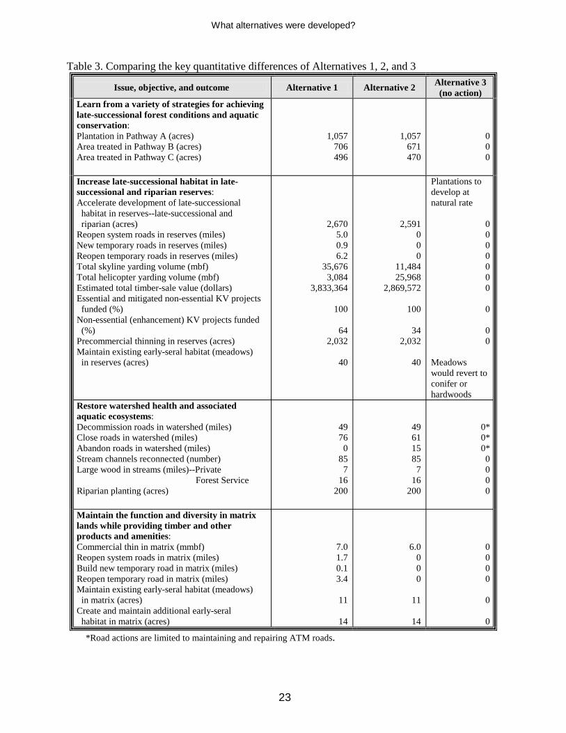
Table 3. Comparing the key quantitative differences of Alternatives 1, 2, and 3
Issue, objective, and outcome Alternative 1 Alternative 2 Alternative 3 (no action)
Learn from a variety of strategies for achieving late-successional forest conditions and aquatic conservation: Plantation in Pathway A (acres) Area treated in Pathway B (acres) Area treated in Pathway C (acres)
1,057 706 496
1,057 671 470
0 0 0
Increase late-successional habitat in late-successional and riparian reserves: Accelerate development of late-successional habitat in reserves--late-successional and riparian (acres) Reopen system roads in reserves (miles) New temporary roads in reserves (miles) Reopen temporary roads in reserves (miles) Total skyline yarding volume (mbf) Total helicopter yarding volume (mbf) Estimated total timber-sale value (dollars) Essential and mitigated non-essential KV projects funded (%) Non-essential (enhancement) KV projects funded (%) Precommercial thinning in reserves (acres) Maintain existing early-seral habitat (meadows) in reserves (acres)
2,670 5.0 0.9 6.2
35,676 3,084
3,833,364
100
64 2,032
40
2,591 0 0 0
11,484 25,968
2,869,572
100
34 2,032
40
Plantations to develop at natural rate
0 0 0 0 0 0 0
0
0 0
Meadows would revert to conifer or hardwoods
Restore watershed health and associated aquatic ecosystems: Decommission roads in watershed (miles) Close roads in watershed (miles) Abandon roads in watershed (miles) Stream channels reconnected (number) Large wood in streams (miles)--Private Forest Service Riparian planting (acres)
49 76
0 85
7 16
200
49 61 15 85
7 16
200
0* 0* 0* 0 0 0 0
Maintain the function and diversity in matrix lands while providing timber and other products and amenities: Commercial thin in matrix (mmbf) Reopen system roads in matrix (miles) Build new temporary road in matrix (miles) Reopen temporary road in matrix (miles) Maintain existing early-seral habitat (meadows) in matrix (acres) Create and maintain additional early-seral habitat in matrix (acres)
7.0 1.7 0.1 3.4
11
14
6.0 0 0 0
11
14
0 0 0 0
0
0
*Road actions are limited to maintaining and repairing ATM roads.

What alternatives were developed?
24
Table 4. Comparing likely effects of Alternatives 1, 2, and 3, based on the issues, objectives, and outcomes
Issue, objective, and outcome Alternative 1 Alternative 2 Alternative 3 (no action)
Learn from a variety of strategies for achieving late-successional forest conditions and aquatic conservation
Increases learning through a more effective monitoring strategy
Increases learning through a more effective monitoring strategy
Does not achieve the objectives of the management study
Increase late-successional habitat in late-successional and riparian reserves
Maintains stand health and accelerates growth of trees in plantations Increases stand complexity and diversity in plantations
Maintains stand health and accelerates growth of trees in plantations Increases stand complexity and diversity in plantations
Stand health and growth will decline Stands will develop at a rate different from natural stands of comparable age
. Restore watershed health and associated aquatic ecosystems
Reduces effects of road sediments on streams Reconnects stream channels Reduces effects of roads on low, peak, and storm flows Reduces effects of roads on large-wood recruitment and debris flows Increases stream and riparian reserve complexity
Reduces effects of road sediments on streams Reconnects stream channels Reduces effects of roads on low, peak, and storm flows Reduces effects of roads on large-wood recruitment and debris flows Increases stream and riparian reserve complexity
No change No change No change No change No change
Maintain the function and diversity in matrix lands while providing timber and other products and amenities
No commercial timber harvest in mature stands Increases complexity and diversity in plantations Provides 7 mmbf of timber
No commercial timber harvest in mature stands Increases complexity and diversity in plantations Provides 6 mmbf of timber
No change No change Provides no timber volume
Aquatic conservation objectives
Moves toward historical conditions and meets all objectives
Moves toward historical conditions and meets all objectives
Watershed differs from historical conditions

What alternatives were developed?
25
Table 5. Comparing likely effects of Alternatives 1, 2, and 3 on water quality, based on short-term (ST) and long-term (LT)* changes from existing conditions
Actions and water-quality issues Alternative 1 Alternative 2 Alternative 3 (no action)
Commercial thinning Stream temperature Peak, storm, and low flows Sediment production Plantation thinning Log hauling
No change No change
No change ST increase
LT no change
No change No change
No change ST increase
LT no change
No change No change
No change No change
System (classified) road actions Sediment production Reopen (6.7 mi., Alt. 1) Close (76 mi., Alt. 1; 61 mi. Alt. 2) Decommission (49 mi.) Abandon (15 mi., Alt. 2)
ST increase LT no change LT decrease ST increase LT decrease
N/A
No change
LT decrease ST increase LT decrease LT Increase
No change
No change No change
LT Increase
Temporary (unclassified) road actions Sediment production New (1.0 mi., ridgetop locations, Alt. 1) Reopen (9.6 mi., Alt. 1)
No change ST increase
LT no change
No change No change
No change No change
Large wood in streams Stream temperature Sediment production In-stream sediment retention
Decrease
ST increase LT no change LT increase
Decrease
ST increase LT no change LT increase
No change No change
No change
Riparian planting Stream temperature
ST no change LT decrease
ST no change LT decrease
No change
Snag and coarse wood creation Stream temperature
No change
No change
No change
Precommercial thinning Stream temperature
No change
No change
No change
New road to access private land (0.5 miles, primarily on ridgetop) Sediment production
No change
No change
No change
*ST = short term or up to 5 years; LT = long term or more than 5 years.

What alternatives were developed?
26

What alternatives were developed?
27
See Map 6

What alternatives were developed?
28
See Map 6

What alternatives were developed?
29
See Map 7

What alternatives were developed?
30
See Map 7

What alternatives were developed?
31
See Map 8

What alternatives were developed?
32
See Map 8

What are the existing conditions?
33
What are the existing conditions CHAPTER 3 in the Five Rivers area?
In chapter 3, we describe the existing environmental conditions on the lands proposed for management actions; it is equivalent to the traditional section, “Affected Environment”.
The Lobster-Five Rivers Watershed Analysis (USDA 1997a) and the Late-Successional Reserve Assessment, Oregon Coast Province Southern Portion (USDA, USDI 1997) describe the attributes of the Five Rivers-Lobster Creek watershed much more fully than do the short summaries that follow. Land Status The Plan designated federal lands in this area as late-successional reserve, riparian reserve, or matrix (land not allocated as one of the two kinds of reserves). The size, ownership, and allocations for each of the subwatersheds is shown in table 6. Land allocations are shown on maps 6, 7, and 8. The area also contains lands designated by the U.S. Fish and Wildlife Service as critical habitat for the northern spotted owl (USDI 1992) and the marbled murrelet (USDI 1996). No wilderness or roadless areas are in or adjacent to the planning area. Table 6. Land ownership and federal land allocations
Subwatershed
Total area
(acres)
Federal
land (acres)
Private
land (acres)
Siuslaw
NF (%)
Private
land (%)
Late- successional
reserve (%)
Riparian reserve
(%)
Matrix
(%)
Cascade Creek 3,573 3,485 88 98 2 6 74 18 Crab Creek 4,935 4,609 326 93 7 40 45 8 Green River 6,198 5,506 692 89 11 46 36 7 Lower Buck Creek 4,184 3,481 703 83 17 11 57 15 Lower Five Rivers 4,374 3,194 1,180 73 27 45 18 1 Middle Five Rivers 4,374 3,380 994 77 23 73 3 1 Upper Buck Creek 3,642 3,106 536 85 15 65 16 4 Upper Five Rivers 5,730 5,320 410 93 7 93 0 0
Total 37,010 32,081 4,929 87 13
Climate and Substrate Climate Climate interacts with the land to create the fertile temperate rain forest of the Oregon Coast Range. Soft, sedimentary rocks weather to form permeable, fertile soils prone to landslides. High rainfall and frequent landslides have sculpted a complex topography of short, steep slopes with many streams per square mile.

What are the existing conditions?
34
Cool, wet winters and warm, dry summers are the norm in the watershed. Temperatures range from about 34OF in January to about 76OF in August, averaging about 53oF. The annual rainfall is 80 to 100 inches; about 90% of it falls between October and May. Snowfall is occasional but rarely lasts longer than a day or two. Rock and soils The watershed is underlain by fine-grained sandstones and siltstones, called the Tyee formation. Light, permeable soils develop quickly on this easily weathered sedimentary rock. Landslides are frequent on slopes of more than 70% at the heads of streams, usually creating debris flows in the channels. These debris flows deliver most of the sediment and large wood that are important to creating stream complexity and fish habitat. Stream sediments are mostly gravel to fine sand; large rock fragments break down in tens to hundreds of years. Dense volcanic rocks sometimes cap the ridges or appear as narrow ribbons of erosion-resistant rock along streambeds. The weathering products of these rocks are more durable than the ones from sedimentary rocks; the process of decomposing to sands and silts may take thousands of years. Hydrologic Conditions and Water Quality The planning area is part of the Five Rivers-Lobster watershed, a tributary of the Alsea River basin. Eight subwatersheds make up the area (table 6). Although Buck Creek and Five Rivers function as hydrologic units, they are subdivided for management. These eight subwatersheds comprise 456 stream miles, slightly more than half the total for the Five Rivers-Lobster watershed. Stream flow is significantly higher in winter than in summer. Flow rates respond quickly to rainfall, in part because soils are generally thin with little storage capacity. Floods are due to high rainfall storms and rain-on-snow events. The planning area had a large flood in 1972, according to stream-gauge records that go back 30 years. Adjacent watersheds had major floods in 1964, 1974, and 1996. These streams are typical of Coast Range watersheds underlain by the Tyee formation sandstone: # Drainage patterns are branched, with some streams entering obliquely and others at nearly
right angles. # Drainage densities are high, ranging from 6.3 to 8.8 miles per square mile. # Low-gradient channels are common; 7.1% of stream miles have a gradient less than 4%. # Riffle streambeds commonly consist of gravel and cobbles embedded with sand, which
may impair fish spawning and rearing. # Boulders are rare, so large logs and woody material are required to provide channel
roughness in most stream reaches. # Many stream reaches contain few large logs and little woody material. # Beaver dams are important for creating pools and storing water.

What are the existing conditions?
35
Mid-slope and valley-bottom roads disconnect stream channels. Roads crossing streams create a potential barrier that may slow or keep coarse sediments and large wood from moving. They are a potential source of management-related sediment themselves, if they fail. Forest Service roads in the Five Rivers watershed cross streams at 125 sites. A total of about 32,100 cubic yards of fill material are contained at these sites (table 7). Forty-seven percent of fill volume is in the Upper Five subwatershed, 18% in the Lower Five subwatershed, 13% in the Green River subwatershed, and 10% in the Cascade subwatershed. Based on recent road condition surveys, some culvert inlets at stream crossings are plugged or partially plugged and thus more likely to deliver road-related sediment to streams than culverts with clear or open inlets. A plugged inlet can lead to failure of the road fill material, or a stream can be diverted out of its channel if the culvert inlet becomes plugged and water is ponded behind the fill. Fill volumes associated with these high-risk stream crossings are shown in table 7. Fifty-nine of the 125 stream crossings have this potential to divert water (table 7). Table 7. Existing road conditions at stream crossings and fill volumes
Subwatershed Number of stream- crossing sites
In-stream fill volumes in cubic
yards
High-risk in-stream fill volumes in
cubic yards
Stream crossing- sites with potential
to divert water Cascade 20 3,300 200 6 Crab 4 600 0 2 Green River 51 4,200 1,400 20 Lower Buck 12 1,500 800 5 Lower Five 7 5,700 200 7 Middle Five 5 800 30 4 Upper Buck 1 900 900 0 Upper Five 25 15,100 1,000 15
Total 125 32,100 4,530 59 Note: Numbers are taken from road-fill assessment tables in the project file. Water temperature has been monitored by the Oregon Department of Fish and Wildlife, Bureau of Land Management, Oregon State University, and the Forest Service for the last six years. Based on their work, the Oregon Department of Environmental Quality placed Cascade Creek and Five Rivers on the 303(d) list (water-quality limited) for elevated summer water temperatures in 1996. Buck Creek and Green River were added to the list in 1998 (DEQ 1998). These streams have seven-day average maximum water temperatures higher than 64 degrees F., exceeding the water temperature beneficial to native fish. High water temperatures are due to various factors. The principal source of heat for small forest streams is sunlight on the stream surface (Brown 1985). Over the last 60 years, riparian vegetation in some areas of Five Rivers on the National Forest has been converted from a mix of conifers and deciduous trees to meadows or small deciduous trees, increasing stream surface exposed to sunlight. Vegetation was converted by unstable sediment caused by large woody debris removal, valley-bottom roads, homesteads, and timber harvest adjacent to perennial streams. Channel widening from large sediment pulses also increased stream surface exposed to sunlight. Substrate removal from channel scour or stream clean-out exposed subsurface water to sunlight. All these factors are likely to have contributed to increased stream temperatures.
What are the existing conditions?
36
Fire Fire has been the primary disturbance influencing the vegetation. Although the frequency of natural fires is unknown, they were likely infrequent (150 to 750 years apart) and probably large, high-intensity, stand-replacing fires during extreme weather cycles, particularly periods of prolonged drought or high lightning activity. Fire was used as a tool by American Indians and by Euroamerican settlers to clear forests for farming, livestock grazing, and homesteading. These planned fires often escaped and grew large before they were extinguished by major changes in weather. Human activities probably caused the Yaquina Fire of 1849, which burned some 148,000 acres including most of the planning area. After the fire, other settlement fires reburned portions of the same area; the fire of 1914, for example, burned most of the area north of the town of Fisher and the southern portion of Upper Buck subwatershed. Fire became a common tool in the mid 1900s as a site-preparation treatment after timber harvest. The resulting fires, along with earlier human-caused fires, resulted in some areas being burned 3 or 4 times in the last 150 years, a 12-fold increase over natural rates. Currently, the highest potential for ignition is by people. Fires are most likely to be started by recreational users of the forest, commercial activity, and arson. Most if not all lightning is accompanied by a significant amount of rainfall, sufficient to reduce the probability of wildfire. Human Uses and Influences Heritage resources Documentation of American Indian use of the interior valleys of the Coast Range is limited. The Kalapuya from the Willamette Valley and the Alsea from the coast may have used the stream-side zone occasionally for summer travel routes, trade, and gathering resources (like fish, lamprey, hazel nuts). Homesteading began in the 1870s, and the last pulse was in the early 1920s. Fewer than 150 people currently live there. Valley bottoms adjacent to Five Rivers and its main tributaries were the preferred settlement sites. Agriculture and livestock were the primary means of subsistence until the onset of logging in the 1940s. Grazing and farming required removing trees from valley-bottom lands, including trees growing adjacent to streams. Industrial timber harvest began on private lands in 1940 and peaked in the 1950s. Timber harvest on public lands began in the early 1950s and peaked in the early 1980s. By then--and into the early 1990s--private lands were being harvested a second time. From the early 1990s, mature timber has not been harvested on federally managed lands in the watershed because of court injunctions and subsequent changes in management direction provided by the Plan. Recreation The watershed has no developed recreation. People engage in a variety of dispersed recreational activities, similar to historical uses--hunting, fishing, sight-seeing, berry picking, and camping--

What are the existing conditions?
37
on a limited and seasonal basis. Elk and deer hunting is considered the predominant recreational activity. Special forest products Greenery (salal, sword fern, evergreen huckleberry, and dwarf Oregongrape), moss, firewood, transplants (shrubs, tree seedlings), mushrooms, Christmas trees, and cascara bark are the primary special forest products gathered through leases (greenery contracts) and permits (miscellaneous forest products). Four greenery leases are currently active in the planning area. Public and Management Access The area has a high density of roads, reflecting the extensive human activities in the watershed. The initial primary road system, serving homesteads and timber harvest, is reflected in the current county road system and predates the 1950s. This system was used to haul timber to local mills, as well as to mills on the coast or in the mid-Willamette valley. About one-half of the area’s roads are in the valley bottoms, along rivers and streams, and on mid-slope terrain. Beginning in the late 1960s, federal roads were built, connecting all the major ridge tops and side ridges to the valley-bottom road system. The federal roads, in conjunction with county roads, provided year-round access for administrative and general public use. Although the Five Rivers county road provides a direct route to State Highway 34, local residents have relied on the extensive forest road system for more direct and convenient access to valley communities like Eugene and Corvallis and coastal communities like Yachats and Florence. Federal roads have a design life of about 30 years; major culverts and bridges were designed to withstand 50-year peak-flow events. Approaching 30 years old and older, many of these roads have corroded and failing galvanized steel culverts. Asphalt concrete surfacing continues to age, showing signs of subgrade settlement and failures. Severe winter storms between 1996 and 1999 caused many steep hillsides above and below roads to slide, taking portions of roads with them. The proposed National Forest Road Management Strategy (USDA 2000b) would revise policy on how a Forest transportation system is developed and managed. By this strategy, roads will be developed and managed in a way that considers the benefits and costs of access and road-associated effects on the ecosystem. The Five Rivers Landscape Management Project has incorporated these concepts in determining the actions for roads in the Five Rivers watershed. No unroaded areas, as defined under the proposed national strategy, are in the Five Rivers watershed nor are any designated roadless areas. The Siuslaw’s Access and Travel Management (ATM) Guide (USDA 1994) defines a permanent, strategic road system maintained for both car and truck traffic throughout the watershed (map 9). A total of 174 miles of Forest-development roads plus 27 miles of county roads now constitute a road-density range of 2.4 to 3.2 miles per square mile of watershed. The combined annual daily traffic counts on Forest Service roads in the watershed average 9 vehicles daily; Road 32 is the most heavily used (13 vehicles daily). The average annual cost for maintaining and repairing the ATM system (51 miles of primary and secondary roads) in the planning area is about $225,000. The non-ATM system is maintained by
What are the existing conditions?
38
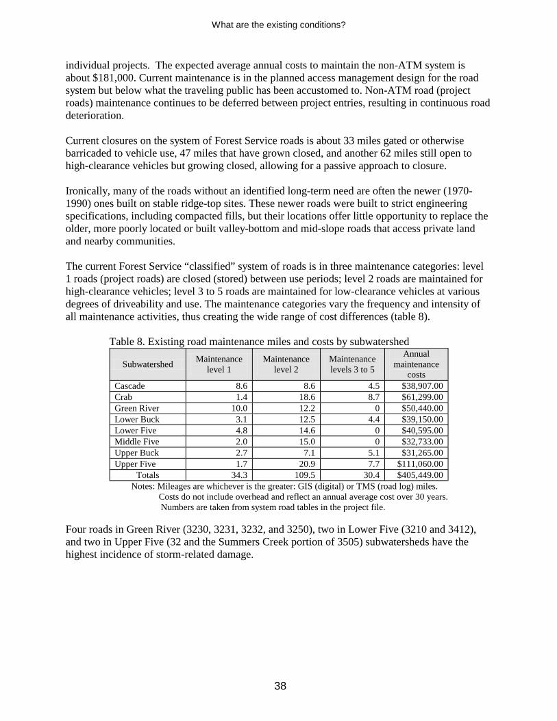
individual projects. The expected average annual costs to maintain the non-ATM system is about $181,000. Current maintenance is in the planned access management design for the road system but below what the traveling public has been accustomed to. Non-ATM road (project roads) maintenance continues to be deferred between project entries, resulting in continuous road deterioration. Current closures on the system of Forest Service roads is about 33 miles gated or otherwise barricaded to vehicle use, 47 miles that have grown closed, and another 62 miles still open to high-clearance vehicles but growing closed, allowing for a passive approach to closure. Ironically, many of the roads without an identified long-term need are often the newer (1970-1990) ones built on stable ridge-top sites. These newer roads were built to strict engineering specifications, including compacted fills, but their locations offer little opportunity to replace the older, more poorly located or built valley-bottom and mid-slope roads that access private land and nearby communities. The current Forest Service “classified” system of roads is in three maintenance categories: level 1 roads (project roads) are closed (stored) between use periods; level 2 roads are maintained for high-clearance vehicles; level 3 to 5 roads are maintained for low-clearance vehicles at various degrees of driveability and use. The maintenance categories vary the frequency and intensity of all maintenance activities, thus creating the wide range of cost differences (table 8). Table 8. Existing road maintenance miles and costs by subwatershed
Subwatershed Maintenance level 1
Maintenance level 2
Maintenance levels 3 to 5
Annual maintenance
costs Cascade 8.6 8.6 4.5 $38,907.00 Crab 1.4 18.6 8.7 $61,299.00 Green River 10.0 12.2 0 $50,440.00 Lower Buck 3.1 12.5 4.4 $39,150.00 Lower Five 4.8 14.6 0 $40,595.00 Middle Five 2.0 15.0 0 $32,733.00 Upper Buck 2.7 7.1 5.1 $31,265.00 Upper Five 1.7 20.9 7.7 $111,060.00
Totals 34.3 109.5 30.4 $405,449.00 Notes: Mileages are whichever is the greater: GIS (digital) or TMS (road log) miles. Costs do not include overhead and reflect an annual average cost over 30 years. Numbers are taken from system road tables in the project file. Four roads in Green River (3230, 3231, 3232, and 3250), two in Lower Five (3210 and 3412), and two in Upper Five (32 and the Summers Creek portion of 3505) subwatersheds have the highest incidence of storm-related damage.

What are the existing conditions?
39
Terrestrial and Aquatic Conditions and Species Forest stand conditions Before the 1800s, most of the Five Rivers land was in old-growth forest of Douglas-fir, western hemlock, and western redcedar, growing in very large stands of more than 100,000 acres. The existing natural stand structure resulted from the Yaquina Fire of 1849 (Juday 1977) and subsequent, smaller fires. These stands are now primarily Douglas-fir, though scattered, old remnant trees and old-growth patches persist on low slopes and in valley bottoms. Other tree species are generally lacking, except along the southern boundary of the project area, where western hemlock and western redcedar are regenerating, and the area north of Fisher that has more hardwood and hardwood-conifer mixed stands than farther south. Existing natural conifer stands are fragmented, and patch size is now less than 2,000 acres (map 9). Few large snags and logs are in these stands, but the amounts are within the range of natural variability. Laminated root rot, brown cubical rot, Swiss needle cast, and Douglas-fir beetles are found throughout these stands but not at epidemic or outbreak rates. In 1982, insect and disease surveys on the former Alsea Ranger District showed that 73% of the 11 stands surveyed in the planning area were infected with laminated root rot (Goheen et al. 1982). Inoculation rates were found to be as high as any sites in the Pacific Northwest. Additional surveys in 1984 and 1985 (Goheen et al. 1986) and stand exams in 1998 identified additional sites of infestation, further extending its known distribution. These exams also found Swiss needle cast in some of the stands, with trees showing needle loss and abnormal diameter growth. Forest management Commercial harvest of mature and old-growth stands on federal lands began in the 1950s, with a focus on intensively managing for timber products. Management usually included these activities: # Clearcut harvesting; # Yarding of dead and downed logs; # Site preparation (chemical, before 1984; manual, after); # Broadcast burning (before 1992); # Planting 400 to 500 trees per acre (mostly Douglas-fir before 1980; after, planting included
western hemlock, Sitka spruce, and western redcedar); # Controlling competing and unwanted vegetation (chemical, before 1984; biological or
manual, after); # Precommercial thinning, at ages 10 to 15, to 250-300 trees per acre; and # Commercial thinning planned at ages 30 to 35.
Federal plantations (map 10) now account for 15,627 acres: 4,091 acres are 5 to 15 years old; 3,124 acres are 16 to 24 years old; and 8,412 acres are 25 years old and older.
This intensive regime resulted in very uniform stands dominated by Douglas-fir. By age 30, growth rates and crown ratios in these dense stands are beginning to decline. Mortality of

What are the existing conditions?
40
suppressed and intermediate conifers and hardwoods is increasing. Because of past management actions, current amounts of coarse woody debris (snags and logs) are very low. Downed wood biomass in Oregon Coast Range forests should range from 525 to 4,839 ft3/acre (USDA, USDI 1997), but only a few managed stands in the area have more than 500 ft3/acre. Dense canopy closure in many stands has resulted in little or no understory, reducing structural and species diversity. Aquatic species Populations of wild salmonids in the Alsea basin, except those of fall chinook and resident cutthroat trout, are depressed (ODFW 1997). Overfishing, habitat degradation, hatchery-fish interactions, and poor ocean conditions have all contributed to the decline of wild fish (NRC 1996). Salmonid distribution in summer is similar to the distribution of the best remaining habitat, with most fish in headwater portions of major tributaries (MCWC 1998). Winter distribution of salmonids is not documented, but it is assumed to shift downstream into the lower portions of the major tributaries. Five Rivers supports populations of fall chinook and Oregon coast coho salmon (listed as threatened in August 1998), winter steelhead, sea-run and resident cutthroat trout, speckled dace, Pacific lamprey, and a few species of sculpins. Five Rivers and its tributaries are major contributors to salmonid production in the Alsea basin. The potential for high-quality habitat is high in Five Rivers and its tributaries because of its abundance of low-gradient stream channels with wide valley floors. Before settlement, these conditions probably produced some of the best habitat for coho salmon in the Alsea basin. Human activities (settlement, timber harvest, roads, and removal of large wood from streams) have reduced both the amount and quality of fish habitat in the planning area. Reduced shade has raised water temperatures in summer, limiting salmonid rearing capacity in most moderate to large fish-bearing streams. Substantially reduced numbers of large conifers in riparian areas are expected to keep fish habitat in poor condition for decades. Mid-slope and valley-bottom roads have disconnected many stream channels, creating barriers that slow or prevent aquatic species from moving. Fine sediments eroding from roads and culvert failures degrade spawning gravels by filling in substrate spaces, eliminating oxygen needed by developing eggs and fry. The best remaining habitat is in the headwater portions of major tributaries with less than 2% gradient (upper Five Rivers, Green, Crab, and Buck subwatersheds). In these areas, riparian vegetation is least disturbed, summer stream temperatures are lower, large wood is more abundant, and stream channels are more connected to their floodplains than they are downstream. Beaver ponds are a major source of high-quality fish habitat, particularly in the upper portions of large tributaries. Terrestrial species The watershed analysis describes a fragmented landscape for wildlife. In all subwatersheds, mature forest habitat is below 40%, and interior mature forest is less than 15%. All interior forest habitat patches are smaller than 170 acres (table 9). Early-seral habitat ranges between 8 and 17% in the subwatersheds. Current habitats favor species more closely associated with fragmented landscapes and with early- and mid-seral communities. The species currently known to depend on mature and old-growth habitat, as well as those found in young and fragmented

What are the existing conditions?
41
habitats, are listed in the watershed and late-successional reserves assessments (USDA 1997a; USDA, USDI 1997). Table 9. Mature and interior forest habitat
Subwatershed
Total area
(acres)
Mature habitat (acres)
Mature habitat
(%)
Interior habitat (acres)
Interior habitat
(%)
Maximum interior
patch size (acres)
Cascade Creek 3,573 985 28 79 2 79 Crab Creek 4,935 1,671 34 345 7 105 Green River 6,198 1,804 29 465 8 104 Lower Buck Creek 4,184 1,323 32 261 6 168 Lower Five Rivers 4,374 1,326 30 242 6 110 Middle Five Rivers 4,374 1,490 34 364 8 86 Upper Buck Creek 3,642 1,403 39 528 14 125 Upper Five Rivers 5,730 2,024 35 645 11 61 Total acres or average percentage 37,010 12,026 32 2,929 8 105
Listed and sensitive species--Proposed actions may affect bald eagles, northern spotted owls, and marbled murrelets, all listed as threatened under the Endangered Species Act of 1973, as amended. A full description of their status in the planning area may be found in the biological assessment prepared for this project. The biological assessment disclosed that: # The planning area is outside the range or contains no suitable habitat for the Oregon
silverspot butterfly, brown pelican, Aleutian Canada goose, Nelson’s sidalcea, western lily, or western snowy plover. # About 2,350 acres are suitable (mature conifers one mile on either side of major rivers, and
0.5 mile on either side of major tributaries) bald eagle habitat, including 150 acres on private land. # No bald eagle nesting territories are in the area. # One pair and three resident, single northern spotted owls have been documented. # The reproductive status of the owl pair has been evaluated annually since 1991; the status
of resident singles has been evaluated about every other year. No spotted owl reproduction has been documented between 1991 and 1999. # On federal lands, the riparian reserve land allocation is intended to serve as connectivity
corridor between late-successional reserves for dispersing owls. In each of the subwatersheds, at least 68% of each riparian reserve functions as dispersal habitat, and at least 69% of each subwatershed currently functions as dispersal habitat. # About 360 acres of plantations develop annually into dispersal habitat. # About 44 occupied marbled murrelet sites are in or within 1/4 mile of the planning area. # Although the area has not been surveyed for marbled murrelets since 1992, the likelihood
is about 90% that suitable habitat is occupied by marbled murrelets, based on Siuslaw NF survey experience.

What are the existing conditions?
42
Regionally sensitive and survey-and-manage species--Regionally sensitive, as well as survey-and-manage species, have been documented in the area. Review of the watershed analysis, subsequent evaluations, and surveys show that: # Although more than 55% of the area is considered potential habitat for red tree voles, a
secondary prey species of the owls, their natural distribution is somewhat clumped and patchy (USDA, USDI 1999a). Although documented in younger forests, such as plantations, these habitat types are most likely population sinks and unlikely to provide population persistence of red tree voles over the long term (USDA, USDI 2000). # The papillose taildropper slug has been found in 25 stands being considered for treatment. # The planning area contains about 20,500 acres of suitable habitat for six protection-buffer
fungal species. Proposed commercial thinning units contain about 3,200 acres of suitable habitat for these species.
Other species of regional or social concern--Other species of regional or social concern have been documented in the area. Review of the watershed analysis and subsequent evaluations show that: # Managing and enhancing elk habitat have been emphasized in the area. # Five Rivers is considered one of the better hunting areas in the Alsea subunit. # The Landbird Strategic Plan (USDA 2000c) focuses on watershed health and restoration,
sustainable forest ecosystem management, forest roads, and recreation. # Neotropical bird restoration efforts focus on the larger international issues of maintaining
populations in both their winter and summer ranges. # Six populations of loose-flowered bluegrass are designated as buffered (protected)
populations under the Conservation Strategy for Poa laxiflora (USDA 1993). # Populations of noxious weeds are common in disturbed sites such as log landings, pastures,
and along roads.

What are the existing conditions?
43
See Map 9

What are the existing conditions?
44
See Map 9

What are the existing conditions?
45
See Map 10

What are the existing conditions?
46
See Map 10
What are the environmental effects?
47
What environmental effects are CHAPTER 4 predicted for each alternative?
In chapter 4, we predict the likely effects of the actions under each alternative (corresponding to the traditional section, “Environmental Consequences”). Environmental conditions described in chapter 3 set the baseline from which direct, indirect, and cumulative effects are analyzed in chapter 4. The Northwest Forest Plan, FEMAT report, Late-Successional Reserve Assessment, and the Lobster-Five Rivers Watershed Analysis provide evidence for baseline environmental conditions. These broad-based assessments of environmental conditions provide a cumulative view of environmental conditions at different landscape scales and consider past, present, and reasonably foreseeable actions. One advantage of planning the Five Rivers Project at the landscape scale (37,000 acres in the project area) is an improved analysis of cumulative effects. Knowing the site-specific details of all projects in a large geographic area, allows us to predict cumulative effects with more certainty than if projects were analyzed individually. The analysis of direct and indirect effects in this chapter inherently includes cumulative effects because all foreseeable future federal actions in the watershed are included in the analysis. Cumulative effects are summarized on pages 78, 79, and 80 and include how all actions (including those expected from other landowners) affect each resource.
In this chapter, we predict the likely environmental effects of the proposed alternatives, whose outcomes are based on the assumption that the project design criteria (appendix B) have been followed. These criteria were also used during formal consultation with the National Marine Fisheries Service and will be used by the U.S. Fish and Wildlife Service to evaluate effects on listed species. The use of these criteria is reflected in the amount of take and in the terms and conditions provided in the biological opinions issued by these agencies. Based on the science literature and our collective experience, we are confident in the accuracy of our analysis of the current conditions discussed in chapter 3. In chapter 4, when we describe the environmental effects of each alternative, we are predicting those effects based also on the literature and our collective experience; however, we recognize that predictions are inherently uncertain, some just a little and some highly. Because of the similarities of environmental conditions and ecological processes found in the planning area, we expect site-specific effects and environmental responses to the proposed actions to be fairly uniform throughout. In the following pages, therefore, we expect our generalized discussions on effects can be applied to any given location in the landscape with a high degree of confidence that the effects described will fit the site. When the Forest Supervisor chose the members of the interdisciplinary team, he considered possible scenarios for this environmental impact statement and determined what disciplines would illuminate decisions about them. Relying on his professional judgment and expertise, he chose the disciplines and formed the team of Forest experts in those disciplines. Team members reviewed areas where actions are proposed, reviewed relevant refereed literature and

What are the environmental effects?
48
Forest assessments for this planning area, and consulted disciplinary colleagues in the Forest Service, other agencies, universities, and elsewhere. Often, literature reviewed by team members was deemed incomplete and, though studies of similar environments and similar scenarios were reviewed, the expert’s professional judgment was required to determine what information can be appropriately used here--and how strongly it supports predictions about what the environmental effects of proposed actions will be. Although team members benefit from the array of research information and the insights of colleagues, they are valued most highly for their experience in and knowledge about the Five Rivers area. Consultation with other experts helps assure that the literature review did not miss a valuable resource, and it provides opportunity to debate and strengthen the team expert’s conclusions about how proposed actions are likely to affect the environment. After several team meetings and one-on-one discussions among team members on how each one’s predictions might affect or be affected by all of the others, each team member wrote a section of this chapter. Then all of them reviewed the whole chapter to be sure they find the others’ predictions clear and supportable. In this chapter, team members’ names accompany their written contributions to indicate that they believe the cited references are relevant, the inferences drawn from them are appropriate, and the predictions are supported by the cited literature and their own professional judgment. In this section, a single author uses “I”; when “we” is used, it means one or more other team members concur.
Predicted Effects of Actions To Compare Strategies in the Management Study (Bernard Bormann) Learning from a management study that compares three different management pathways will inform and improve future land management decisions (Bormann et al. 1999). Both Alternatives 1 and 2 would implement such a study (appendix A), based on adaptive management principles and incorporating scientific design concepts to increase confidence in interpreting the outcomes, to improve actions for meeting the Plan goals of developing late-successional habitat and restoring watershed health. Alternatives 1 and 2 provide for applying the management study under the most restrictive standards and guides for each land allocation. The management study does not allow applicable standards and guides to be eased on any land allocation. Alternative 3 provides no mechanism for a comparative management study. Except for land status, and public and management access, effects on the resources are similar--that is, on soils, stream flow, water quality, fire, human use and influences, forest stand conditions, aquatic species, and wildlife habitat. Alternatives 1 and 2 provide a forum to illuminate the debate on how well the selected management strategies allow the landscape to develop late-successional-forest conditions and healthy watersheds. This approach is expected to accelerate the rate at which management actions are improved. Under Alternative 3, the agency

What are the environmental effects?
49
would continue to depend on a fragmented approach of monitoring individual actions. Historically under this approach, improvements in management actions have been slow. Land status Applying the study design under Alternatives 1 and 2 would place 461 acres of matrix into the passive management pathway. Although placement would not change the allocation of these lands for the current planning period, these lands would have no stand management and limited aquatic restoration actions. Public and management access Alternative 2 would result in the loss of access to study area 4C (map 5), reducing the number of study replications for this pathway from 4 to 3. Although this reduction will make it much more difficult to identify differences between pathways, the management study will remain viable. Access to the remaining study areas could also be lost in the long term, thereby eliminating the benefits of the management study. Typically, about 5% of Forest funds is used for monitoring Forest projects. The Team regards the management study as an opportunity to more effectively use the funds intended for monitoring on the Forest. Because of its identified monitoring strategies and priorities, the management study is expected to be a high priority for Forest funding relative to other Forest projects.
Predicted Effects of Actions To Address the Shortage of Late-Successional Habitat Soils, stream flow, and water quality Soils (Courtney Cloyd)--In a study of sediment production from forest roads in western Washington, Reid and Dunne (1984) found that road-use intensity directly affected the volume of fine sediment eroded from road surfaces. Road use is compared to sediment production in table 10 (modified from Reid and Dunne’s table 4). These authors attribute the sediment yield associated with paved roads to cutbank and ditch erosion. Soils in the Five Rivers watershed are generally similar to those of Reid and Dunne’s study area, as are road conditions. An average of 3 to 4 log trucks per day is expected for a typical skyline cable thinning sale. Where helicopter yarding is used, 8 to 10 log trucks per day are expected, but fewer roads would be used for hauling. Many of the roads are on ridgetops with no stream crossings, so no sediment is expected to enter streams from there. In the short term, sediment yield from log-truck traffic will increase where mid-slope and valley-bottom roads cross streams. Sediment yield from log-truck traffic will be lower than predicted by models such as used in table 10 because constant reduced tire pressure will be required (appendix B, page B-5). A study of central tire inflation (reduced air pressure in tires) on the Siuslaw National Forest (USDA 1988) showed less wheel-track rutting during log haul, and a significantly reduced need for road maintenance (blading) during wet-season haul. We have observed a direct relation between road blading and increased fine sediment loss during wet-season haul. Reduced need for road surface

What are the environmental effects?
50
blading will reduce the volume of fine sediment available for delivery to streams. A 3-year study by Foltz (1994) on the Lowell Ranger District of the Willamette National Forest showed 15 to 59% reductions in road sediment yields with a constant reduced tire pressure of 70 pounds per square inch (psi) compared to the yields with a standard highway tire pressure of 90 psi. The greater reductions were during heavier rainfall. Table 10. Average sediment yields from road use
Road type and amount of use Sediment yield, tons/mile per year
Heavy use (more than 4 log trucks per day)
887.40
Moderate use (1-4 log trucks per day)
74.60
Light use (no log trucks) 6.80 Paved 3.50 Abandoned (no vehicle use) 0.90
Luce and Black (1999) reported that sediment production from forest roads in the Oregon Coast Range varies with foundation soil characteristics. They also found that vegetated inboard drainage ditches and cut slopes reduced sediment production by about 7 times compared with cut slopes and ditches cleared of vegetation by road maintenance. Their findings indicate that actual sediment yields are likely to vary from yields estimated by predictive models such as used in table 10 (Reid and Dunne 1984). Duncan et al. (1987) cite studies of road-surface sediment routing in large western Oregon and Washington watersheds that determined 20% of the road runoff points (ditch relief culverts) discharged onto the forest floor, and 80% emptied into stream systems. Of those stream-entry drainage points, 88% entered first- or second-order channels, and 13% emptied into year-round water courses. Duncan et al. also found that at least 55% of all road surface erosion was deposited between 311 and 410 feet from the entry point. They found that the finer sediment fraction tended to move farther from the entry point than did coarse sediment, and that lower stream gradients and large woody material in the channel more effectively trapped and held sediments than did other configurations. I have observed comparable sediment routing and deposition in the Oregon Coast Range, where about 90% of the first- and second-order channels contain water year-round. Alternative 1 road management actions will have the following effects on soils, hydrologic conditions, and water quality:
Reopening and using existing temporary roads
# Because project design criteria (appendix B, pages B-5 through B-7) were based on the evidence presented, I expect a reduction of at least 20 to 60% in the sediment volumes predicted in table 10. After projects are completed, I expect fine sediments from closed roads to be in the range of the light use and abandoned categories (table 10). Decommissioned roads should yield sediments in the range of the abandoned road category.
# Based on local experience, and from monitoring past projects, construction sediment that cannot be practicably removed from the stream channel generally

What are the environmental effects?
51
# erodes during high winter flows in the first two or three winters after excavation. Disturbed areas are usually revegetated, and stream channels have reached equilibrium after 5 years, so that management-related sediment entering streams is near zero. Therefore, I expect the volume of management-related fine sediment delivered to streams at each crossing’s culvert installation or removal site to be less than 5 cubic yards.
# Based on local experience, unused roads on the Siuslaw National Forest are usually covered with leaf litter and vegetation within 5 years of closure, which effectively eliminates road surface erosion.
# Studies of mechanical compaction in forest soils cited in Froelich and McNabb (1983) show that three decades or more may pass before compacted soils return to their former bulk densities and porosities by natural processes. They evaluated two tillage methods, disk harrows and a prototype winged subsoiler. Both methods were found to increase soil shattering, which facilitates aeration and disaggregation. Froelich and McNabb also reviewed other studies that showed mechanical tillage of several compacted soil types improved conifer growth, apparently as a result of increased aeration and reduced soil strength. Based on these studies and our field observations, we expect improved conifer growth when new and existing temporary roads are subsoiled after use.
# Based on local experience, repairing and stabilizing minor road failures and improving road drainages reduces the potential for new failures on reopened roads.
Building and using new temporary roads
# I have observed that soil erodes for 2 or 3 years after roads are built, transporting small volumes of sediment beyond the fillslope limits, particularly during rainstorms. This material usually stops moving within 50 to 100 feet of the fill-slope. Beyond that point, the transporting water disappears into the porous forest floor (Bilby et al. 1989). No road-building or haul-related sediment is expected to reach a stream because all proposed new temporary roads would be on ridges and more than 100 feet from streams.
# The effects of compaction will be similar to those described under reopening temporary roads.
Closing roads between treatments
# Based on Reid and Dunne’s (1984) sediment production rates (table 10), we expect closed roads to produce less sediment than those remaining open to vehicular traffic.
Alternative 2 road management actions will have the same effects as Alternative 1’s, with these differences:
Reopening existing and building new temporary roads # No temporary roads will be reopened or built to accomplish commercial
thinning, so no short-term sediment will be produced from these roads.

What are the environmental effects?
52
By implementing project design criteria--such as requiring constant reduced tire pressure for log trucks, avoiding blading of ditches as much as possible, monitoring roads during heavy rains, using straw bales as sediment traps where needed, and limiting some log hauling to the dry season--we expect significant reductions of sediment yield compared to the yields shown in table 10. Because of these mitigating actions, we do not expect Alternatives 1 and 2 to have significant adverse effects on water quality (appendix B, page B-5). Stream flow (Courtney Cloyd)--Studies cited in the Alsea watershed study (Brown 1972) document increases in streamflow after clearcut logging and partial thinning, and the more extensive the clearcutting, the greater the increase in streamflow. In another study of the Alsea experimental watersheds, Harr and Krygier (1972) found an increase in low-flow rates for 2 of 5 study years in a 750-acre watershed that was 25% patch cut. After 5 years, no trend toward pre-logging low flow rates was found. Harr (1976), evaluating four paired watershed studies in western Oregon including the Alsea basin, indicates that annual water-yield increases decline over time, but they may take more than 20 years to return to pre-logging yields. Based on results of six paired watershed studies in western Oregon, including the Alsea watershed study, Harr (1983) notes that water yield increases are eliminated after about 27 years because of vegetation regrowth. The Five Rivers area has the same underlying geology and geomorphology as the Alsea watershed study, and the drainage densities and stream gradients are similar as well. These areas share the rainfall-dominated climate of the Oregon Coast Range, where storm flow is the result of rain events with high intensity, long duration, or both. Under Alternatives 1 and 2, plantations will be thinned on 4.8 to 15% of each subwatershed's acreage, or 8.7% of the project area (table 11). Because the affected area of each treated subwatershed is small and the past effects of clearcut logging may still influence stream flows, we do not expect plantation thinning to measurably increase peak, storm, and low flows. Table 11. Thinning acres by subwatershed
Subwatershed Total area
(acres)
Commercial thinning (acres)
Commercial thinning
(%) Cascade Creek 3,573 211 5.9 Crab Creek 4,935 747 15.0 Green River 6,198 469 7.6 Lower Buck Creek 4,184 472 11.3 Upper Buck Creek 3,642 367 10.0 Lower Five Rivers 4,374 211 4.8 Middle Five Rivers 4,374 233 5.5 Upper Five Rivers 5,730 520 9.1 Totals 37,010 3,230 8.7
Alternative 3 will not change current stream flows. Water quality (Jan Robbins)--Studies of streams in small Coast Range watersheds by Brown and Krygier (1970), Brazier and Brown (1973), and Brown (1972) determined that tree shading provided by unlogged buffers between streams and clearcut units prevented water temperature increases. Brown (1972) found that water temperatures declined when streamside vegetation

What are the environmental effects?
53
returned after logging. Brazier and Brown (1973) found that 79-foot-wide buffer strips provide maximum shading to streams. Beschta et al. (1987) found, in western Oregon, that buffer strips at least 100 feet wide between small streams and clearcuts provide about as much shading as an old-growth forest does. Beschta et al. (1987) cited one study in the Oregon Coast Range that showed 50% of a stream was shaded 5 years after clearcutting and burning. Harris (1977) noted that stream temperatures in Deer Creek and Needle Branch subwatersheds in the Alsea watershed study were trending back toward prelogging conditions 7 years after harvest. Brown and Krygier (1970) noted that the increase in stream temperature for a given exposure to sunlight (loss of shade) is inversely proportional to stream volume. Small, shallow streams are more affected by shade loss than are larger streams, and temperatures in all streams are most affected by shade loss during low-flow periods in summer. Based on information in the studies cited, most effective stream shading is within the first 30 feet of stream centers. Under Alternatives 1 and 2, thinning plantations to within 90 feet of streams will have no effect on water temperature. Thinning to within 50 feet of streams is unlikely to have any measurable effect on stream temperature. The effects of thinning are expected to decrease in 5 to 10 years as canopy closure approaches 80%. Fire (Carl West) Based on Forest fire records since 1975, the Siuslaw National Forest has averaged 11 fires, burning about 35 acres a year. People caused about 95% of those fires; in other words, on this Forest, most fires are in accessible areas. Therefore, though commercial thinning may increase fuel loading, reduced access because of road closures is likely to reduce the risk of fire ignitions. Because the potential for fire ignition cannot be eliminated, however, the team is obligated to disclose the potential for wildfire as a result of an ignition in a commercial thinning unit. In the Five Rivers watershed, about 40 acres of commercial thinning units lie adjacent to and within 25 feet of ATM roads. Fuel treatments such as burning hand-piled slash will be adjacent to and within 25 feet of these roads, after thinning operations are completed, to mitigate the potential for wildfire. Hand-piled burning is not expected to adversely affect the Corvallis airshed, but it may cause some short-term localized negative effects to air quality. Andersen (1982) developed aids to assist fuels and fire behavior analysts in determining an appropriate fuel model or models for estimating potential fire behavior. He developed 13 fuel models representing the various components of living and dead vegetation in forests or range-lands across North America. Andrews’ (1986) fire-behavior program (BEHAVE) predicts fire behavior characteristics such as fireline intensity, rates of spread, and resistance to control. Using these tools--along with local knowledge and weather variables from Cannibal Mountain--I expect thinning under Alternatives 1 and 2 to have the following effects on fuels and the potential results from fire ignitions: # Commercial thinning in the managed stands will increase fuels on the forest floor, as will
adding coarse woody debris gradually. % Fuels created from slash will result in the thinning units’ falling under the light-
slash fuel model (fuel model 11) in the light-to-moderate thinning units and the medium-slash fuel model (fuel model 12) in moderate to heavy thinning units.

What are the environmental effects?
54
% The fuels are expected to decay over time, decreasing the risk of wildfires.
Observations of past thinning have shown decomposition of the fine fuel component (needles and twigs) in 3 to 4 years. This period would be when the thinning slash could support a surface fire.
% Leaving whole trees on the ground as coarse wood increases resistance to control by fire suppression resources beyond that for fine fuels.
# Fire behavior in thinning slash in late summer would create fireline intensities and flame lengths difficult for hand and engine crews to suppress safely and successfully by direct attack. % Roads and skid trails would be the primary control lines in indirect suppression,
likely increasing the number of acres burned. % The late-successional reserve objective to limit the size of all wildfires in the
reserve would be difficult to meet. # Increased fireline intensity could increase the cumulative effects on other resources.
% Soils could be damaged by burning off nutrients and organic matter and increase potential for overland flow.
% The severity of any damage would be directly linked to the intensity of the fire. # Increasing the number of thinned units in a given area increases the hazard with a larger
area of contiguous fuels. Spotting from one thinned unit to another is likely, given the wind speed that would be expected on a high fire-danger day.
Alternative 3 will not change the current potential effects from fire ignitions. As roads continue to deteriorate, access to fires will continue to become more difficult. Human uses and influences Heritage resources (Ken McCall)--I searched the literature to determine if known heritage resources (historical and archaeological sites) exist in the planning area and found no sites likely to be affected by this project. Actions--such as reopening system roads, building new temporary roads, reopening temporary roads, and commercial thinning--are on previously disturbed sites and will not require field inventories, based on our 1995 agreement with the State Historic Preservation Office (appendix B, pages B-2 and B-3, provides additional information about our agreement). Recreation (Ken McCall)--The primary consequence of the proposed actions would be to change from motorized to nonmotorized access, a process already happening under the ATM system and road decommissioning across the Forest. The highest concentration of vehicle travel on the interior forest will continue to be associated with hunting seasons. Access to dispersed recreation sites will be maintained under all alternatives. Scenery (Jessica Dole)--Proposed actions are consistent with the scenic-quality objectives for the planning area. Proposed thinning actions are expected to increase the scenic value of the planning area in the long term by restoring the landscape to a generally continuous (less fragmented) forest with mostly larger diameter trees. The existing scenery in the Alsea River corridor will not be affected because the proposed actions will be in areas not visible from the Alsea River-Highway 34 scenic corridor.

What are the environmental effects?
55
Special forest products (Paul Thomas)--Opportunities to gather special forest products through permits and leases will continue. Limited vehicle access will make collecting special forest products more difficult. The value of recent sales (summer 1999) of special forest products on the Waldport Ranger District are about 30% lower than for previous sales. These rates reflect an over commitment on past sales and more difficult access (Palmer, pers. comm.). Public and management access (Dan Mummey) Under Alternative 1, about 133 miles of system roads will remain, including about 15 miles of private-lands access leading from county roads. Changes in ATM routes will amount to about 2.4 additional miles of ATM travel on ridgetops around the segment of road 32 (primarily valley-bottom and mid-slope road) should this road segment be decommissioned. Alternative 2 will abandon (eliminate road maintenance) non-ATM roads as they fail. Initially, Alternative 2 will maintain 15 fewer miles than Alternative 1 because some roads are blocked by slides or other failures. The following summarizes the effects of Alternatives 1 and 2: Alternatives 1 and 2
# During timber harvest, periods of frequent log-truck traffic would affect county and Forest roads. Although these roads were built and maintained to support timber harvest, about 6 years has elapsed since the last harvest of timber from these federal lands; thus, log-truck traffic may be a new experience for some residents not accustomed to meeting these vehicles on narrow roads.
# Between resource management activities, closing roads reduces vehicular access for resource managers and forest users.
Alternative 2
# By abandoning roads as they fail, Alternative 2 will reduce the number and kinds of actions--such as thinning managed stands and decommissioning roads--for meeting the goals of the late-successional reserve and aquatic conservation strategies.
Forest stand conditions (Ed Obermeyer) To analyze Alternatives 1 and 2 treatment effects, the ORGANON (Oregon growth analysis and projection) model was used to model individual tree growth by using the Stand Management Coop (SMC) version (Hann et al. 1997) developed from permanent plots in western Oregon, Washington, and British Columbia. A summary of a model run on stand 224 indicates that the following effects can be expected from the different thinning treatments (table 12):
# Diameter growth rates will increase, accelerating the development of large-diameter trees. At age 80, the average stand diameter will be 30 inches dbh, with 40 trees per acre (TPA); trees in the 100 trees-per-acre treatment will not reach this size until after 117 years.
# Height growth rates are comparable for all treatments. Although heavy thinning treatments (40 TPA) are at a higher risk to blowdown for a few years, height-diameter relations are more favorable under this treatment, so trees are less prone to blowdown and breakage over time.

What are the environmental effects?
56
# By allowing an understory to develop, heavy-thinned stands will result in multi-aged,
two-storied stands. Lightly thinned stands (100 TPA) will continue to be dense and single-storied until further thinning or natural disturbances reduce their density.
# Increased growth rates will accelerate developing high-quality snags and coarse woody debris. Mortality will increase in the lightly thinned treatment, creating large amounts of woody debris and snags (28 in 80 years), but most of them will be small and likely to decay rapidly because of the high percentage of inner bark and sapwood. These physiologically active tree tissues are the first components of downed trees to decay (Maser and Trappe 1984). Half of the mortality will be in trees less than 20 inches in diameter. Heavy thinning treatments will allow larger, longer lasting material to develop for snags and coarse woody debris, but natural mortality will account for only 3 trees in 80 years. This material will be relatively large, however--about 20 to 30 inches in diameter.
# Live-crown ratios will increase for a while after all treatments before beginning to decline, unless stands are thinned again. Larger ratios will be maintained longer under heavy than under light thinning. Crown ratios will remain above 30% until age 100 in the heavy thinning, compared to about age 65 in the light thinning. Live-crown ratio can be considered an index of individual tree vigor (Oliver and Larson 1996). Trees with large crown ratios will not only grow faster, but will be more resistant to insects, diseases, and other environmental hazards.
Additional analysis indicates that:
# In a study on 10 sites in the Oregon Coast Range, Tappeiner et al. (1997) found that trees in old-growth stands had little competition from one another because of the low numbers of trees per acre. Young plantations, such as those on the Five Rivers watershed, were planted--after logging--at 500 to 700 trees per acre, and only a few of the stands were thinned to 60 to 100 trees per acre. We expect that proposed heavy thinning will allow residual trees in those stands to develop on a trajectory consistent with natural old-growth stand development.
# Tappeiner et al. (1997) also found that self-thinning was uncommon during the development of the older stands studied, indicating that canopy gaps in these forests were the result of conifer establishment as well as mortality of individual, large trees. Therefore, selecting trees for thinning based on a variable distribution should create numerous small openings in these stands that more closely mimic natural stand development. My observations of commercial thinnings, such as Big Elk Timber Sale on the Waldport Ranger District, indicated that diameter-limit thinning was effective in creating these openings.
# A density-management study conducted on the Waldport and Mapleton Ranger Districts (Emmingham 1996) indicated that canopy cover varied from 30 to 70% immediately after commercial thinning when stands were thinned to 30 to 100 trees per acre. Unpublished data 5 years after thinning showed that crown cover had increased to 47 to 82% at the same sites (Chan, pers. comm.). Chan also indicated that most native tree species require a minimum of 30 to 60% open light (canopy openings) to allow for successful establishment and growth. Heavy thinning treatments (40 trees per acre) will increase the amount of light reaching the forest floor and provide a more suitable environment for understory development. This thinning,
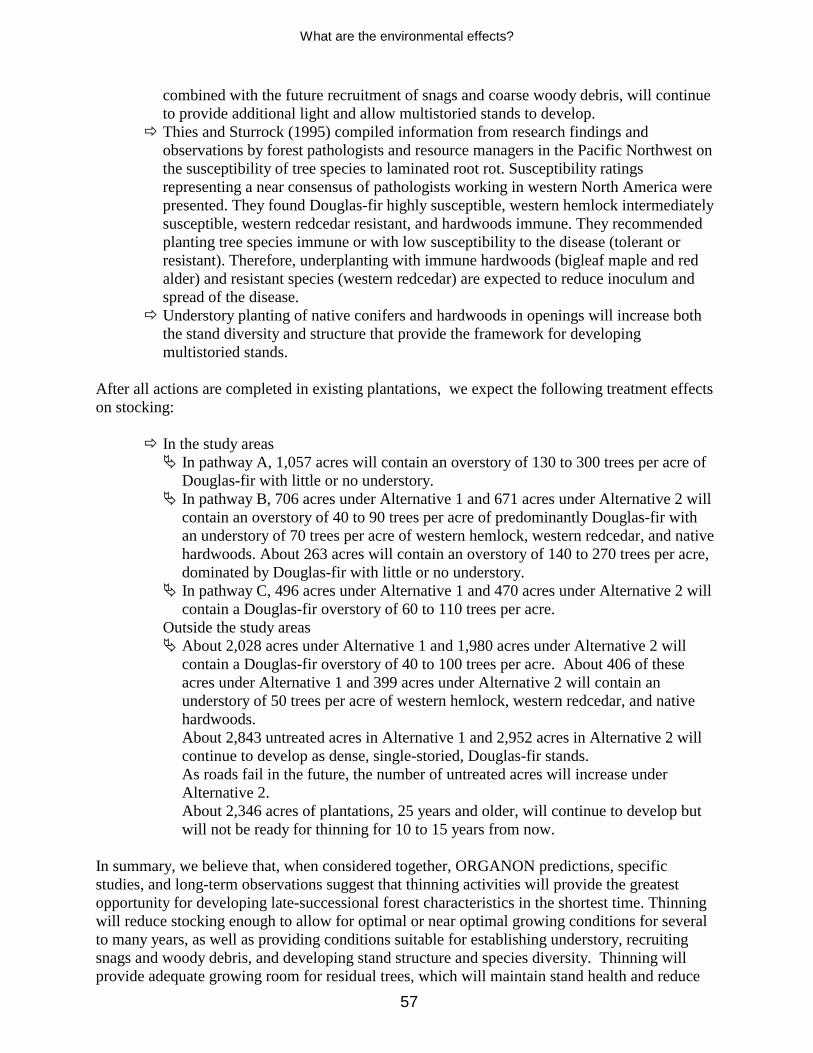
What are the environmental effects?
57
combined with the future recruitment of snags and coarse woody debris, will continue to provide additional light and allow multistoried stands to develop.
# Thies and Sturrock (1995) compiled information from research findings and observations by forest pathologists and resource managers in the Pacific Northwest on the susceptibility of tree species to laminated root rot. Susceptibility ratings representing a near consensus of pathologists working in western North America were presented. They found Douglas-fir highly susceptible, western hemlock intermediately susceptible, western redcedar resistant, and hardwoods immune. They recommended planting tree species immune or with low susceptibility to the disease (tolerant or resistant). Therefore, underplanting with immune hardwoods (bigleaf maple and red alder) and resistant species (western redcedar) are expected to reduce inoculum and spread of the disease.
# Understory planting of native conifers and hardwoods in openings will increase both the stand diversity and structure that provide the framework for developing multistoried stands.
After all actions are completed in existing plantations, we expect the following treatment effects on stocking:
# In the study areas % In pathway A, 1,057 acres will contain an overstory of 130 to 300 trees per acre of
Douglas-fir with little or no understory. % In pathway B, 706 acres under Alternative 1 and 671 acres under Alternative 2 will
contain an overstory of 40 to 90 trees per acre of predominantly Douglas-fir with an understory of 70 trees per acre of western hemlock, western redcedar, and native hardwoods. About 263 acres will contain an overstory of 140 to 270 trees per acre, dominated by Douglas-fir with little or no understory.
% In pathway C, 496 acres under Alternative 1 and 470 acres under Alternative 2 will contain a Douglas-fir overstory of 60 to 110 trees per acre.
� Outside the study areas % About 2,028 acres under Alternative 1 and 1,980 acres under Alternative 2 will
contain a Douglas-fir overstory of 40 to 100 trees per acre. About 406 of these acres under Alternative 1 and 399 acres under Alternative 2 will contain an understory of 50 trees per acre of western hemlock, western redcedar, and native hardwoods.
� About 2,843 untreated acres in Alternative 1 and 2,952 acres in Alternative 2 will continue to develop as dense, single-storied, Douglas-fir stands.
� As roads fail in the future, the number of untreated acres will increase under Alternative 2.
� About 2,346 acres of plantations, 25 years and older, will continue to develop but will not be ready for thinning for 10 to 15 years from now.
In summary, we believe that, when considered together, ORGANON predictions, specific studies, and long-term observations suggest that thinning activities will provide the greatest opportunity for developing late-successional forest characteristics in the shortest time. Thinning will reduce stocking enough to allow for optimal or near optimal growing conditions for several to many years, as well as providing conditions suitable for establishing understory, recruiting snags and woody debris, and developing stand structure and species diversity. Thinning will provide adequate growing room for residual trees, which will maintain stand health and reduce

What are the environmental effects?
58
the probability of large-scale outbreaks of insects or disease. As high-quality snags and coarse woody debris develop over time, late-successional characteristics can be expected to improve gradually. These effects will differ depending on treatment intensity. We believe the only way that thinning could not help these stands develop late-successional characteristics would be if blowdown, or insects and disease outbreaks, affected thinned stands and not unthinned stands. These results appear unlikely, but they cannot be ruled out.

What are the environmental effects?
59
Table 12. ORGANON growth and yield projections for stand 224 Age TPA DBH Height (HT40) Mortality Crown ratio %
40 TPA 37 210 13.1 97 0 32
*37 40 17.0 97 0 36 47 40 20.5 116 0 46 57 39 24.0 136 1 47 67 39 27.0 153 0 41 77 39 29.4 167 0 37 87 38 31.5 180 1 34 97 38 33.3 191 0 31
107 38 34.9 201 0 29 117 37 36.2 210 1 27
45 TPA 37 210 13.1 97 0 32
*37 45 16.8 97 0 36 47 45 20.2 116 0 46 57 44 23.6 136 1 45 67 43 26.4 152 1 39 77 43 28.8 167 0 35 87 43 30.7 179 0 32 97 42 32.4 191 1 29
107 42 33.9 201 0 27 117 41 35.2 209 1 25
60 TPA 37 210 13.1 97 0 32
*37 60 16.3 97 0 35 47 59 19.5 116 1 45 57 58 22.5 136 1 40 67 57 25.0 153 1 35 77 56 27.0 167 1 31 87 55 28.8 179 1 28 97 54 30.3 190 1 26
107 53 31.6 200 1 24 117 52 32.8 208 1 23
80 TPA 37 210 13.1 97 0 32
*37 80 15.8 97 0 34 47 78 18.7 117 2 42 57 76 21.3 136 2 36 67 74 23.5 153 2 31 77 72 25.2 167 2 28 87 70 26.8 179 2 25 97 68 28.2 191 2 23
107 66 29.4 199 2 22 117 63 30.6 208 3 20
100 TPA 37 210 13.1 97 0 32
*37 100 15.3 97 0 35 47 97 18.1 117 3 39 57 94 20.4 136 3 33 67 90 22.3 153 4 29 77 87 23.9 167 3 26 87 83 25.4 179 4 23 97 80 26.7 190 3 22
107 76 27.9 200 4 20 117 72 29.1 208 4 20
No Action 37 210 13.1 97 0 32 47 188 15.2 119 22 30 57 168 17.0 138 20 26 67 149 18.8 154 19 23 77 132 20.4 169 17 22 87 118 21.9 181 14 20 97 107 23.4 192 11 19
107 97 24.8 200 10 19 117 89 26.2 208 8 18
* = after thinning; TPA = trees per acre; DBH = diameter at breast height; Height (HT40) = height of 40 tallest trees.

What are the environmental effects?
60
Timber-sale economics (Bruce Buckley)--Commercial thinning under Alternative 1 in late-successional and riparian reserves will produce about 32 million board feet. Thinning in matrix lands will produce an additional 7 million board feet. Commercial thinning under Alternative 2 in reserves will produce about 31 million board feet, and an additional 6 million board feet will be produced in matrix. The economic analysis used the transaction-evidence appraisal (TEAECON) program developed by the Mount Hood National Forest. This program--developed for planners in Oregon and Washington--is used to analyze basic gross timber values and develop estimated advertisement rates for sales greater than 250 thousand board feet. The program accounts for Forest Service expenses associated with planning, sale preparation, and sale administration. The primary factor affecting the difference in expected advertised rates between alternatives is the higher costs associated with helicopter logging, which has a lowering effect on advertised rates . Under Alternative 1, helicopter logging comprises about 9% of the total volume; under Alternative 2, helicopter logging comprises more than half the volume (appendix C, C-3 and C-4). Based on recent (spring 2000) market rates in Oregon and Washington, advertised rates for potential bidders would be $98.90 for Alternative 1 and $76.62 for Alternative 2 per thousand board feet. At these rates, Alternatives 1 and 2 would generate sufficient revenue to cover Forest Service expenses, provide revenue to counties pursuant to the “Secure Rural Schools and Community Self-Determination Act of 2000”, provide 10% of gross value to roads and trails, fund all essential Knutson-Vandenberg (KV) projects, such as underplanting in heavy thinning areas, and fund all mitigated non-essential KV projects such as snag and down wood creation. Essential KV and mitigated non-essential KV projects have the highest funding priorities (appendix B, pages B-12 through B-14). As table 13 illustrates, the primary difference between the alternatives is reflected in how well non-essential KV projects are funded. Depending on future market values for small wood, additional funds (or fewer) could be available for non-essential KV projects. Some of the non-essential restoration projects, such as large wood additions for streams and road decommissioning, are likely to be funded from other sources and therefore received low priority rankings for KV funds. Likely funding sources for large wood addition projects include Forest Service appropriated dollars, KV dollars from previous sales, and cooperative grants with other entities. Likely funding sources for road decommissioning include funds from flood supplemental, road maintenance, and soil and water dollars. Costs of large wood ($300,000) and road decommissioning ($107,200) projects comprise about 17% of the total costs for non-essential KV projects under both Alternatives 1 and 2. Because these projects will most likely not be funded by KV, these costs were not included in table 13. Table 13. Estimated sale value, collections, KV project costs, and percentage of non-essential KV projects funded
Altern- atives
Total sale value
NFF collections
Essential KV and mitigated non-essential KV projects
SSF collections
Total non-essential KV
projects
Percentage of non-
essential KV projects
funded 1 $3,833,364.00 $1,341,677.00 $722,105.00 $530,178.00 $1,945,265.00 64 2 $2,869,572.00 $1,004,350.00 $691,729.00 $512,287.00 $1,948,070.00 34

What are the environmental effects?
61
Young-stand management (Ed Obermeyer)--About 2,366 acres of young plantations (ages 5 to 15) will be available for treatment. Although many research projects have been initiated to study how stand management activities affect the development of late-successional conditions in older stands, younger plantations have received little or no study. My own knowledge and observations indicate that younger plantations have better species composition and diversity than are typically found in older plantations because past precommercial thinning usually removed native hardwoods and hemlock. Anecdotal evidence suggests that initiating management activities that maintain species diversity and growth rates at a younger age would allow plantations to develop late-successional characteristics similar to older stands, but more effectively and sooner. Consequently, early silvicultural intervention in young plantations should allow them to grow faster and develop late-successional characteristics sooner than the older stands managed primarily for timber. Effects of Alternatives 1 and 2 are expected to:
# Reduce stand densities to more closely mimic natural stand development in the project area.
# Maintain or enhance growth rates for several decades, with effects lasting longer in the stands proposed for heavy thinning.
# Increase species diversity because existing native hardwoods will be retained and shade-tolerant conifers will be emphasized over shade-intolerant species. Retaining a wide variety of species will also help accelerate the development of multistoried stands.
# Enhance stand diversity by retaining untreated clumps and stand openings. Variable distribution patterns will allow understory vegetation and structure to develop.
# Develop high-quality snags and large woody debris sooner because high growth rates can be maintained for long periods, providing early recruitment of large-diameter material.
# Increase stand resistance to major disturbances from insects, diseases, or other environmental factors by enhancing stand diversity.
When all actions are completed, the following effects of treatments on stocking can be expected.
# The 2,366 acres of young stands, currently 5 to 15 years old, will contain about 80 to 140 trees per acre. These stands are primarily of Douglas-fir, but they will also contain a component of western hemlock, western redcedar, and native hardwoods.
# In pathway A, 425 acres will not be treated and will continue to develop as dense, Douglas-fir stands with about 300 to 400 trees per acre. An additional 1,300 acres have already been precommercially thinned to 120 to 200 trees per acre. Although dominated by Douglas-fir, they contain a minor component of western hemlock, western redcedar, and native hardwoods.
# Under Alternative 2, fewer acres will become available for commercial thinning in the future as roads fail. Currently, 299 acres or 13% of the young stand acres would not be available for harvest.
No adverse indirect effects are anticipated in thinned areas. These actions will provide a long-term benefit by maintaining stand health and accelerating development of late-successional habitat that includes large trees, snags, logs on the forest floor, canopy gaps, multistoried stands, and diverse species composition. Within about 45 to 80 years, most stands will average 30

What are the environmental effects?
62
inches in dbh and contain high-quality snags and coarse woody debris. Understories, about 40 years old, will add species and structural diversity. Relatively large blocks of multistoried stands will exist across the planning area, as natural and managed stands blend together. Adverse cumulative effects for acres in pathway A, under passive management, and untreated acres would be the same as identified under the no-action alternative. Alternative 3 (no action)--Without harvest activities, 6 to 7 million board feet will not be harvested from lands designated as matrix. About 5,525 acres will continue to develop as dense, single-storied Douglas-fir stands. Plantations will continue to grow over time, but they will develop differently from existing stands that have achieved old-growth dimensions (Tappeiner et al. 1997). Trees will have less opportunity to express dominance because they all have equal growing space as a result of past vegetation management and precommercial thinning. Competition will continue to increase between individuals as trees compete for limited resources, especially light. Trees will grow taller as they strive to obtain sufficient sunlight, but diameter growth will slow in response to loss of crown. As these trees become more dependent on neighboring trees for support they will become less stable. Trees will become more susceptible to insects, disease, and windthrow, and stand health will decline. When trees occupy the available growing space, they will begin the stem-exclusion phase, which effectively prevents other trees from becoming established and starts killing the weaker trees in the stand (Oliver and Larson 1996). Mortality will increase dramatically as the intermediate and suppressed trees lose their ability to compete and die. These dead trees will increase snags and coarse woody debris, but they will be too small to be of high quality and are expected to decay rapidly. As understory vegetation continues to decline, bare mineral soil will become more prominent and additional soil movement can be expected in stands where slopes exceed 30%, based on observations in similar stands on the Waldport Ranger District. Because stands are fairly uniform, opportunities for establishing species or structural diversity through natural processes will remain low for many years, without major disturbance events. Eventually, over long periods, natural disturbance events will create openings in stands, allowing shade-tolerant species to become established in the understory, gradually creating additional structure and diversity. This alternative provides the least opportunity to accelerate development of late-successional conditions, although stand diversity on a larger landscape scale may be enhanced by retaining untreated areas. Late-successional reserve objectives will likely be delayed for many decades in these stands. Effects of applying this alternative are shown in the control plots on the Black Rock study site near Fall City, Oregon (Marshall, pers. comm.). The plots represent an 85-year-old stand that had 486 trees per acre at age 48. Although this stand contains more trees than most of the Five Rivers stands, it does provide a basis for comparing the development of overstocked stands over a long time. Considerable mortality reduced stocking in this stand to 232 trees per acre by 1995, but little or no understory structure or diversity has developed. Although diameter growth has remained small, height growth has continued, producing tall, spindly trees prone to windthrow. Crowns have receded so the trees are less vigorous and more prone to effects of insects, diseases, and other environmental factors. Large numbers of trees continue to die and fall over, but the growing space is quickly used by other trees, preventing any appreciable light from entering the understory. Little vegetation is found on the forest floor; what is there is related to minor

What are the environmental effects?
63
disturbances and unlikely to persist. This process will likely continue until affected by a major disturbance or until trees have had enough time to begin differentiating from their neighbors. Similar results are predicted when the average stand (age 25+) in the Five Rivers project area is modeled by using ORGANON (table 12). Results of this model indicate that:
# Stands will continue to lose crown ratios from now through age 117, ranging from 32 to 18%.
# By age 117, 58% of the stand (121 TPA) will die and become large woody debris or snags. This wood will be relatively small; 92% of it will be less than 20 inches in diameter and 61% less than 15 inches.
# Average stand diameter will be near 26 inches dbh at age 117. # Height of the 40 tallest trees per acre will be 208 feet. Trees will be very tall in
relation to their diameters and remain susceptible to windthrow and breakage. # Crown ratios will continue to decline from now through age 117, indicating that stand
vigor will degrade, becoming more susceptible to insects, diseases, and other environmental factors.
Younger stands, 5 to 24 years of age, will continue to develop into dense, single-storied stands dominated by Douglas-fir. Many of these stands will enter the stem-exclusion phase at a much earlier age than do precommercially thinned stands. Cumulative effects--Within 25 years, virtually all of the managed stands proposed for thinning would be in the stem-exclusion phase, ranging in age from 30 to 75 years old. This condition would persist for many decades until stands differentiate enough to allow for understory vegetation to begin to reappear or natural disturbances create sufficient openings. Stand health will decline, and insect and disease outbreaks will be more severe and cover larger areas. Laminated root rot will continue to play a significant role in maintaining bark beetle populations over time. This root disease will provide a continuous source of favorable host material for beetles between those times when conditions are favorable for outbreaks (Thies and Sturrock 1995). Douglas-fir is likely to continue to dominate these stands until a major disturbance or sufficient smaller disturbances allow shade-tolerant species to become established. Eventually, as seedlings become established and grow, they will provide additional structure and diversity, slowly evolving into multilayered stands. Then, the natural and managed stands would eventually have similar structure. Aquatic species (Jack Sleeper) Thinning and associated actions (reopening roads, haul, and so on) used to develop late-successional habitat are not expected to affect fish directly. In the short term, turbidity and sediment inputs may increase locally during timber haul, road building, and decommissioning. These increases are expected to be insignificant because they will be small, of short duration, and very limited in geographic extent. A review of the biological opinion prepared for this project has concluded, however, that some watershed restoration actions (road decommissioning and placement of large wood in streams) under Alternatives 1 or 2 are likely, in the short term, to adversely affect Oregon coast coho salmon--listed as threatened in August 1998--and their

What are the environmental effects?
64
habitat, but they are expected to have a beneficial effect in the long term. By not thinning managed stands, Alternative 3 will not accelerate the development of large wood for fish habitat. Terrestrial species (Paul Thomas) The Forest Ecosystem Management Assessment Team report (USDA, USDI et al. 1993) summarizes the numerous publications that describe the structure and composition of late-successional and old-growth forest systems. Attributes included the presence of live old-growth trees, snags, fallen trees on land, and multiple canopy layers. These authors also summarize the current understanding of ecological processes that affect the development of these systems, including tree growth and maturation, death and decay of larger trees, low-to-moderate-intensity disturbances, establishment of trees in gaps or under the canopy, and closing of canopy gaps by lateral canopy or understory growth. They suggested that some processes (such as growth, mortality, and understory development) can be accelerated through silvicultural practices, but others (such as maturation of trees and decay of tree boles) require time. In summarizing ecosystem functions, they identified several attributes, such as buffering of microclimate during seasonal climatic extremes, that appear to be lacking or less well developed in managed stands. They conclude that though silvicultural treatments in plantations can, at best, partially restore or accelerate development of some structural and compositional features found in late-successional ecosystems, no certainty exists that old-growth conditions can be created. Because plantations regenerated by different processes than those existing in late-successional forests, however, they conclude that plantations are highly likely to look and function differently from current older stands. In addition, they conclude that maintaining the network of existing natural old-growth stands is important to preserving biodiversity into the future. The Siuslaw’s late-successional reserve assessment (USDA, USDI 1997) summarized the structure and composition of its mature stands. Conifers ranged between 40 and 88 trees per acre, with conifers greater than 21 inches ranging between 23 and 37 trees per acre. Spies et al. (1988) found, in the Oregon Coast Range, that natural young stands contained 70 logs per acre less than 12 inches in diameter, 39 logs in the 12- to 24-inch size-class, and 4 logs greater than 24 inches. They estimated that coarse wood from the previous stand constituted 58% of the total coarse wood found in the stand. Because the amount of existing mature forest will remain the same under the action alternatives, we concluded that natural processes and functions will be the dominant forces in creating the structure and composition of late-successional habitat for wildlife in existing natural stands under all alternatives. Based on the conclusions reached in the section discussing forest stand conditions, Alternatives 1 and 2 will provide more acres with the tree sizes, densities, and stand characteristics associated with mature forests sooner than will Alternative 3. Although tree densities and stand characteristics of plantations that will develop under Alternative 3 are found in natural stands, their quantity and distribution are greater than would be found under natural processes. Increasing the size and amount of coarse wood, snags, or tree species diversity in plantations and hardwood-dominated riparian areas under the action alternatives will result in attributes more like the structure and composition found in natural stands. How well these attributes will function remains uncertain. The amount of coarse wood and snags in plantations will also increase under Alternative 3; however, when compared to natural stands, the difference in size and composition of these components will be greater under this alternative than under the action alternatives.

What are the environmental effects?
65
Listed and sensitive species--As required by the Endangered Species Act of 1973, as amended, a biological assessment (a project-file document) has been prepared for this project. This assessment evaluates and describes the potential effects of proposed actions on species listed--under the Endangered Species Act--that may be found on the Siuslaw National Forest. Because the planning area is outside the range or contains no suitable habitat for the Oregon silverspot butterfly, brown pelican, Aleutian Canada goose, Nelson’s sidalcea, western lily, or western snowy plover, none of the alternatives affect these species. Bald eagle--Because no nest sites are known and Alternatives 1 and 2 will not remove suitable habitat, thinning (commercial and noncommercial) of plantations and improving terrestrial habitat will not affect bald eagle habitat. Because the location of the activities is frequented by the public (for example private property, public access) and interest in bald eagles is high, an active nest is likely to be discovered. Because a bald eagle pair might nest in the project area and not be discovered, noise associated with management activities could conceivably disturb a nesting pair. Thus, the noise associated with management activities conducted under Alternatives 1 and 2, may affect but are not likely to adversely affect undetected nesting bald eagles. Northern spotted owl--Changing canopy cover, or altering snag, or coarse wood composition modifies forest habitats that support spotted owls. The plantations evaluated for thinning are not considered suitable nesting, roosting, or foraging habitat for the northern spotted owl but they are considered suitable dispersal habitat. Although heavy thinning (less than 40% crown closure) is expected to promote the structural development and diversity of the stand over the long term, the dispersal function of those plantations would be lost for 3 to 5 years. Light and moderate thinning is considered to degrade but not remove dispersal habitat. Because large snags are a component found in nesting and roosting habitat, creating snags in natural stands increases the structural complexity of those stands, but removing hazard trees (snags or deformed trees) adjacent to travel routes and work areas reduces stand complexity. The amount of federal land that will function as dispersal habitat in the riparian reserves and across the landscape after the activities of commercial harvest, coarse wood creation, and inoculation of plantation trees is shown in tables 14 and 15. The primary influence on projected dispersal habitat is the increase in acres of plantations that will meet dispersal-habitat criteria over those currently available. Because heavy thinning of about 400 acres of plantations will not result in dispersal habitat less than is currently available and light-to-moderate thinning of 2,850 acres of plantations will not eliminate dispersal habitat, enough of it will remain to support dispersing owls after all actions are completed.

What are the environmental effects?
66
Table 14. Percentage of riparian reserve that functions as dispersal habitat
Subwatershed Current (2000)
dispersal habitat percentage
Alternatives 1&2 dispersal habitat
(2005) percentage
Alternative 3 dispersal habitat
(2005) percentage
Cascade Creek 71 76 79 Crab Creek 68 72 72 Green River 77 82 84 Lower Buck Creek 71 80 82 Lower Five Rivers 83 88 88 Middle Five Rivers 72 74 76 Upper Buck Creek 78 78 80 Upper Five Rivers 70 74 74
Table 15. Percentage of federal land that functions as dispersal habitat
Subwatershed Current (2000)
dispersal habitat percentage
Alternatives 1&2 dispersal habitat
(2005) percentage
Alternative 3 dispersal habitat
(2005) percentage
Cascade Creek 71 75 79 Crab Creek 69 74 74 Green River 76 81 82 Lower Buck Creek 70 79 80 Lower Five Rivers 77 82 82 Middle Five Rivers 76 77 78 Upper Buck Creek 78 78 80 Upper Five Rivers 69 74 74
Short-term effects on northern spotted owls and their habitat of selecting Alternatives 1 or 2 are summarized in table 16. The effects on owls from noise-associated disturbance during Alternatives 1 and 2 actions are shown in table 17. Except for maintaining or repairing the ATM-system roads, Alternative 3 would cause no noise-associated disturbance to owls. Marbled murrelet--Plantations proposed to be commercially thinned under Alternatives 1 and 2 contain trees less than 130 feet tall and no remnant trees (trees with structure) from the previous stand. Therefore, they are not considered to be suitable or potential marbled murrelet habitat. Noise associated with thinning, including activities like creating coarse wood, could disturb nesting activities on adjacent occupied habitat. Hazardous trees will be removed as part of maintaining roads. Removing trees that have no potential nesting structures would not affect marbled murrelets. Effects on marbled murrelet habitat are shown in table 16. The effects on marbled murrelets from noise-associated disturbance from Alternatives 1 and 2 are shown in table 17. Except for road maintenance or repair of the ATM system, Alternative 3 would have no noise associated with disturbance.
Actions proposed under Alternatives 1 and 2 are expected to speed the development of characteristics associated with late-successional forests. Concern remains over the amount, quality, and use of existing habitat as well as the breeding success of northern spotted owls and marbled murrelets, however. All management activities change existing forest structure and its development, create noise, and--depending on the season-- create smoke or dust, all of which affect the forest environment. Because potential for northern spotted owls or marbled murrelets to use an area being treated or a nearby stand always exists, some risk remains that changing existing conditions may change use patterns, increase susceptibility to predation, or disturb breeding activity. Thus, some risk of
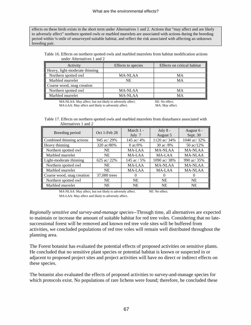
What are the environmental effects?
67
effects on these birds exists in the short term under Alternatives 1 and 2. Actions that “may affect and are likely to adversely affect” northern spotted owls or marbled murrelets are associated with actions during the breeding period within ¼-mile of unsurveyed suitable habitat, and reflect the risk associated with affecting an unknown breeding pair.
Table 16. Effects on northern spotted owls and marbled murrelets from habitat modification actions
under Alternatives 1 and 2 Activity Effects to species Effects on critical habitat
Heavy, light-moderate thinning Northern spotted owl MA-NLAA MA Marbled murrelet NE MA Coarse wood, snag creation Northern spotted owl MA-NLAA MA Marbled murrelet MA-NLAA MA
MA-NLAA: May affect, but not likely to adversely affect. NE: No effect. MA-LAA: May affect and likely to adversely affect. MA: May affect. Table 17. Effects on northern spotted owls and marbled murrelets from disturbance associated with Alternatives 1 and 2
Breeding period Oct 1-Feb 28 March 1 - July 7
July 8 - August 5
August 6 - Sept. 30
Combined thinning actions 945 ac/ 29% 145 ac/ 4% 1120 ac/ 34% 1040 ac/ 32% Heavy thinning 320 ac/80% 0 ac/0% 30 ac /8% 50 ac/12% Northern spotted owl NE MA-LAA MA-NLAA MA-NLAA Marbled murrelet NE MA-LAA MA-LAA MA-NLAA Light-moderate thinning 625 ac/ 22% 145 ac / 5% 1090 ac/ 38% 990 ac/ 35% Northern spotted owl NE MA-LAA MA-NLAA MA-NLAA Marbled murrelet NE MA-LAA MA-LAA MA-NLAA Coarse wood, snag creation 37,080 trees 0 0 0 Northern spotted owl NE NE NE NE Marbled murrelet NE NE NE NE
MA-NLAA: May affect, but not likely to adversely affect. NE: No effect. MA-LAA: May affect and likely to adversely affect. Regionally sensitive and survey-and-manage species--Through time, all alternatives are expected to maintain or increase the amount of suitable habitat for red tree voles. Considering that no late-successional forest will be removed and known red tree vole sites will be buffered from activities, we concluded populations of red tree voles will remain well distributed throughout the planning area. The Forest botanist has evaluated the potential effects of proposed activities on sensitive plants. He concluded that no sensitive plant species or potential habitat is known or suspected in or adjacent to proposed project sites and project activities will have no direct or indirect effects on these species. The botanist also evaluated the effects of proposed activities to survey-and-manage species for which protocols exist. No populations of rare lichens were found; therefore, he concluded these

What are the environmental effects?
68
species would not be affected. Management recommendations for giant-spored tree moss (USDA, USDI 1996) suggest that managing for this species would be necessary “if known occupied sites are disjunct or highly localized”. The 65 sites in the project area are well distributed in the Five Rivers watershed and surveys throughout the Forest indicate the species is well represented and distributed in the Oregon Coast Range. In addition, giant-spored tree moss was ranked as common to abundant in all but four sites where it was recorded in the project area. For these reasons, the Forest botanist concluded that no specific management prescriptions are needed to ensure the continued viability of giant-spored tree moss in the project area. Areas proposed for commercial thinning support suitable habitat for six protection-buffer fungal species. Surveys are currently required before implementing ground-disturbing actions for five of the six species (USDA 2000a) after a single-season survey (USDA, USDI 1999b). All new sites found during pre-implementation surveys will be protected following the management recommendations for survey and manage fungi (USDA 1997b). Survey-and-manage mollusk species were identified based on existing information indicating their close association with late-successional forests, poor dispersal ability, and vulnerability to disturbance (USDA, USDI 1993). They considered all management activities to be a potential threat to mollusks. The papillose taildropper slug has been found in 25 plantations throughout the planning area. Considering that no late-successional forest will be removed and all known sites in managed stands will be buffered or fully protected, we concluded populations of the papillose taildropper slug will remain well distributed throughout the planning area. Other species of regional or social concern--All alternatives maintain the current existing mature habitat and provide a variety of seral age classes. However, Alternatives 1 and 2 will provide stand characteristics associated with mature forests sooner than Alternative 3. All alternatives will maintain a variety of suitable habitat for land birds. The breeding period for land birds occurs during the same periods as spotted owls and marbled murrelets. Design criteria--such as applying a variety of silvicultral presecriptions, implementing hourly and seasonal operating periods, and limiting the amount of work allowed during breeding periods--reduce the direct effect of management activities on the breeding behavior of land birds. Thus, all alternatives are consistent with the Landbird Conservation Strategy (USDA 2000c). The Forest botanist also evaluated the response of noxious weeds and loose-flowered bluegrass to proposed actions under Alternatives 1 and 2. He concluded that: # Thinning prescriptions that leave residual stand densities of 60 to 100 trees per acre
generally provide adequate canopy coverage to prevent most noxious and undesirable weeds from colonizing.
# Units with long segments of temporary road building, landings with fan-shaped setting, creation of meadows, and silvicultural prescriptions calling for open overstory pockets or gaps will increase the potential for weed colonization and establishment.
# Thinning actions may directly affect some individual loose-flowered bluegrass plants or nonconservation-strategy populations, however; protecting and maintaining the conservation-strategy sites ensures a high probability of the species’ continued viability on the forest.

What are the environmental effects?
69
Predicted Effects of Actions To Improve Watershed Function Soils, stream flow, and water quality Soils (Courtney Cloyd)--Reiter et al. (1995) found that 1 to 4 cubic yards of management-related sediment was eroded after culvert and fill removal at several sites on the Umpqua National Forest in western Oregon. They also found that most of the erosion and sediment movement was after the first high flows in the stream, usually in the first fall and winter after treatment. Decommissioning roads under Alternatives 1 and 2 will have the following common effects on soils, hydrologic conditions, and water quality: # Based on an unpublished 1997 inventory of stream crossing culverts, fill volumes at these
sites range from about 50 to 500 cubic yards. Culvert and fill removal would prevent management-related sediment in this volume range from being delivered to streams by erosion or mass movement.
# Because the removal methods and objectives on the Umpqua National Forest are the same as those proposed under these alternatives--a tracked excavator removing culverts and all fill material, restoring the original channel gradient--1 to 4 cubic yards of management-related sediment would be eroded after fill and culvert removal.
# Removing stream-crossing culverts and fill will allow streams to flow in unrestricted channels.
# Based on earlier discussions of erosion after road closure and decommissioning treatments, minor erosion is expected in the first year or two after building of water-bars or water-dips, though it would last longer if vehicle traffic continued.
Road decommissioning under Alternatives 1 and 2 will remove 85 stream crossings from 11 roads in the Five Rivers watershed (table 18). About 21,900 cubic yards or 68% of the in-stream fill volumes will be removed under both alternatives. Of the remaining in-stream fill volumes, 6,700 cubic yards will be on ATM roads, 2,100 cubic yards will be on closed roads, and 1,500 will be on the lower portion of road 3215 identified as “other roads” on maps 4 and 6 (Cascade subwatershed). By removing the fill associated with the 85 stream crossings, the potential for up to 21,900 cubic yards of sediment entering streams will be eliminated. Stream crossings where culvert inlets are partially or fully plugged are likely to trap stream flow behind the road fill, particularly during storms. These sites are more susceptible than others to erosion or rapid failure of the fill material, which would deliver sediment to streams. Water may also be diverted down drainage ditches or roads, causing off-site problems such as delivering sediment to streams or eroding road surfaces. Recent road-condition surveys indicated that 33 stream crossings in the Five Rivers watershed have a high risk of causing sedimentation of streams (table 19). These sites contain about 4,530 cubic yards of fill material. Through road decommissioning, Alternatives 1 and 2 would remove 24 of these sites most susceptible to failure, leaving in place 9 sites that contain about 1,030 cubic yards of fill material. Five of these remaining sites--three in Lower Buck, one in Lower Five, and one in Upper Five--are on ATM roads where culvert inlets will be maintained open; four of these sites will be on closed roads (table 20). The road-fill assessment tables in the project file provided the numerical information contained in tables 18 through 20.

What are the environmental effects?
70
Table 18. Alternatives 1 and 2 stream crossing and fill volume reductions
Subwatershed Existing number
of stream crossings
Existing in-stream fill
volumes in cubic yards
Number of stream crossings to be removed
In-stream fill volumes to be
removed in cubic yards
Remaining in-stream fill
volumes in cubic yards
Cascade 20 3,300 11 1,800 1,500 Crab 4 600 1 100 500 Green River 51 4,200 51 4,200 0 Lower Buck 12 1,500 0 0 1,500 Lower Five 7 5,700 3 500 5,200 Middle Five 5 800 0 0 800 Upper Buck 1 900 1 900 0 Upper Five 25 15,100 18 14,400 800
Total 125 32,100 85 21,900 10,300 Under Alternatives 1 and 2, road decommissioning will remove 39 of the 57 culverts that could divert streams from their channels if inlets became plugged (table 19). Of the remaining 20 sites, 11 will be on ATM roads with routine maintenance, and 9 will be on closed roads. Table 19. Alternatives 1 and 2 high-risk stream crossing and fill volume reductions
Subwatershed Existing number
of high-risk stream crossing
sites
Existing high-risk in-stream fill volumes in
cubic yards
Number of high-risk sites to be
removed
Remaining high-risk in-stream fill volumes in cubic
yards
Existing - to be removed sites
with potential to divert streams
Cascade 1 200 1 0 6 - 6 Crab 0 0 0 0 2 - 0 Green River 14 1,400 14 0 20 - 20 Lower Buck 5 800 0 800 5 - 0 Lower Five 2 200 1 100 5 - 1 Middle Five 1 30 0 30 4 - 0 Upper Buck 1 900 1 0 0 - 0 Upper Five 9 1,000 7 100 15 - 12
Total 33 4,530 24 1,030 57 - 39 Road closure under Alternatives 1 and 2 will maintain 14 stream crossings containing about 2,100 cubic yards of fill material (table 20). Currently, four stream crossings containing about 630 cubic yards of fill are highly susceptible to failure and likely to add sediment to streams because of plugged or partially plugged culvert inlets. Nine sites have potential to divert streams from their channels. Before roads are closed, culvert inlets will be reopened, drain dips will be built above culverts to keep streams in their channels if culvert inlets are obstructed again, and water bars will be built (appendix B, page B-13). We have observed that drain dips or water bars effectively route surface runoff away from the road when the drainage ditch-and-culvert system is blocked, significantly reducing or eliminating erosion. Minor erosion may continue after water dips or water-bars are built, but we expect it to be minimal except where some vehicle use continues and at rates comparable to those determined in table 9 for abandoned roads.

What are the environmental effects?
71
We have observed that continued vehicle traffic after water-bar installation eventually breaks down the shape of water dips and bars, reducing their ability to route water off the road. If vehicle traffic continues on closed roads, water-bar effectiveness would diminish. During recent winter storms, Forest managers have placed a low priority on post-storm surveys of closed roads because of limited funding and staff time. Walking is the only way to access many closed roads because of thick vegetation or trees. These future road closures may further limit or prevent treating the effects of landslides or erosion. Table 20. Alternatives 1 and 2 stream crossing conditions for proposed road closures
Subwatershed Number of
stream crossings
Existing in-stream fill volumes in cubic yards
Number of high-risk sites
High-risk in-stream fill volumes
Number of sites with potential to divert streams
Lower Buck 7 1,000 2 500 5 Middle Five 4 600 1 30 3 Upper Five 3 500 1 100 1
Total 14 2,100 4 630 9 Under Alternative 2, about 15 roads currently closed by natural events or management action will be abandoned or not reopened, which means they will not be maintained or decommissioned beyond the point of closure. No stream crossings are behind those blockages. Future naturally occurring road blockages, however, such as landslides or fill failures, may prevent access to stream crossings for maintenance. Based on the effects of recent (1996-99) major storm and flood events in the Siuslaw National Forest, we expect that not maintaining culvert inlets or not removing culverts and fill material from stream crossings will increase the probability of diverting streams from their channels or catastrophic fill failure. By not removing culverts and fills, the potential of large-wood delivery to streams via debris flows will be reduced. Under this alternative, if roads are blocked naturally before road decommissioning and closure actions, the number and kinds of possible actions to meet the goals of the late-successional reserve and aquatic-conservation strategies may be significantly reduced. Stream flow (Courtney Cloyd)--Wemple (1994) found that road ditches draining into first- and second-order streams function as extensions of the stream network, increasing local peak flows and storm flows by up to 40% in subwatersheds in the western Cascades. Because the relation between road drainage and streams does not depend on the terrain, we expect that actions under Alternatives 1 and 2 will reduce forest-development road density by almost 1 mile per square mile, and thus they are expected to reduce peak and storm flows in the Five Rivers watershed. We expect stream flows to remain at current rates under Alternative 3. Water quality (Jan Robbins)--The Five Rivers Project Water Quality Restoration Plan--a project-file document that is undergoing review for the listed sections of streams--identifies road decommissioning, large wood placement in streams, and riparian planting as actions that help improve watershed function and lower stream temperature. These actions are part of Alternatives 1 and 2. Conifer planting and release requires removing competing hardwoods, resulting in minor shade loss more than 30 feet from stream centers. Shade loss may locally increase water temperatures until conifer and hardwood growth is sufficient to fill in the open spaces. Considering that riparian planting will be along larger, deeper streams with inadequate shade, we

What are the environmental effects?
72
expect any local increase in water temperatures to be within the current temperature ranges for a given stream. Adding large wood to streams is expected to slow movement of sediment through stream channels and provide stable substrate where vegetation can grow and improve shading. In the long term, cumulative actions under Alternatives 1 and 2 will protect or restore water quality on temperature-impaired streams. Under Alternative 3, riparian shading will increase as trees grow or are naturally established in meadows or other open areas. Water temperature is expected to decrease as tree shading increases, but tree diseases, windthrow, landslide-related debris flows, or other natural disturbances may create openings in riparian areas, allowing localized sun exposure and increased water temperature. Without riparian planting, conversion to conifer trees is not accelerated. Conifers provide more shade than hardwoods do because they grow taller and provide higher quality (longer lasting) large woody debris. Where large wood is lacking in streams, sediment moves rapidly through stream systems. Rapid sediment movement reduces the number of stable stream-adjacent sites that can support the growth and development of vegetation, including large trees that provide shade and large wood. Fire (Carl West) Under Alternatives 1 and 2, decommissioning roads, placing logs in streams, and riparian planting will not change existing fuel conditions in the watershed. Decommissioning roads will reduce public access, reducing the risk of human-caused fires. Decommissioning roads will decrease access and increase the response time of initial fire-suppression efforts, however. Closed roads and reduced maintenance on ATM roads will also increase the response time under all alternatives. Slow response times may allow the size of wild fires to increase. As roads degrade under Alternative 3, response times are also expected to increase. Human uses and influences Heritage resources (Ken McCall)--Under Alternatives 1 and 2, two actions on previously undisturbed ground will require field inventories and concurrence from the State Historic Preservation Office before the actions are implemented. The actions include building a new road to access private land in the Green River subwatershed (maps 3, 5, 7, 8) and placing large wood in streams (maps 2, 4). Riparian planting will not be allowed in areas identified as homestead building sites. No effects are anticipated to known sites because of protection and avoidance measures to be taken when woody debris is placed in streams and trees are planted in riparian areas. Road decommissioning under Alternatives 1 and 2 will have minimal risk of consequences to heritage resources because most are on previously disturbed sites, surveyed sites, or both. Recreation (Ken McCall)--The primary consequence of closed and decommissioned roads under Alternatives 1 and 2 will be the change from motorized to nonmotorized access. The highest concentration of vehicle travel on the interior forest will continue to be associated with hunting seasons. Access to dispersed recreation sites will be maintained under all alternatives. Through time, the same decrease in recreation opportunities associated with roads will be experienced under Alternative 3, as road conditions deteriorate from lack of maintenance.

What are the environmental effects?
73
Scenery (Jessica Dole)--Actions proposed for improving watershed function are consistent with the scenic quality objectives for the planning area. Public and management access (Dan Mummey) Under Alternative 1, about 133 miles of system roads will remain, including about 15 miles of private-lands access leading from county roads. Changes in ATM routes will amount to about 2.4 additional miles of ATM travel on ridgetop locations around the segment of road 32 (primarily valley-bottom and mid-slope road) proposed for decommissioning. Alternative 2 will maintain fewer miles as roads are blocked by slides or other failures. About 33 miles of valley-bottom and mid-slope roads plus 16 miles of ridgetop roads will be eliminated in favor of more stable routes, changing road density from 2.6 miles per square mile of Forest-development road to 2.0 miles per square mile. This change would create a permanent road reduction of about 30%. Alternative 2, in addition to planned decommissioning, permanently closes about 15 miles of non-ATM roads, without subsequent stabilization treatments beyond points of roadbed failures. Road failures, mass wasting, and sedimentation will continue on roads beyond these failed points of access. About 28% of non-ATM roads--35 miles on midslopes and in the drainages outside the proposed passive-management areas--would waste away in the form of additional sedimentation. The effects of Alternatives 1 and 2 are summarized, as follows: Alternative 1
# Closes 76 miles of Forest-system roads (maintenance level 1) between planned access periods.
# Decommissions 49 miles of Forest-development roads. # Decommissions a 3.3-mile segment of road 32 (Upper Five subwatershed), an
ATM secondary low-clearance road, when it fails or unless Lane County accepts a public road easement to maintain the road.
# Adds 5.2 miles of ATM high-clearance road to replace the 3.3-mile segment of road 32 after it has failed. This addition will increase average travel distance by about 2.4 miles for vehicles southbound from the Five Rivers county road.
# Reduces ATM road maintenance costs by about $32,000 and non-ATM road maintenance costs by about $120,000 annually over the next 15 years.
# Keeps county roads and primary and secondary (ATM) Forest roads accessible to all vehicles, but some routes to adjacent communities will be less direct and less convenient for residents.
# Eliminates one alternative route for emergency vehicles or evacuating residents if county roads or primary and secondary Forest roads become blocked during emergencies. The more stable and dependable roads--such as the roads that replace the 3.3-mile segment of road 32--are maintained on the ATM system, however.
# Builds, under a special-use permit, about 1/2 mile of new road to maintain private access lost from decommissioning Green River Road 3231.
# Reduces road density to nearly 1 mile per square mile.

What are the environmental effects?
74
Alternative 2
# Closes 61 miles of Forest-system roads (maintenance level 1) between planned access periods.
# Decommissions 49 miles of Forest-development roads. # Decommissions a 3.3-mile segment of road 32 (Upper Five subwatershed), an
ATM secondary low-clearance road, when it fails or unless Lane County accepts a public road easement to maintain the road.
# Adds 5.2 miles of ATM high-clearance road to replace the 3.3-mile segment of road 32 after it has failed, increasing average travel distance by about 2.4 miles for vehicles southbound from the Five Rivers county road.
# Eliminates road maintenance on 15 miles of non-ATM roads, with potential of another 20 miles over the next 15 years by abandoning road access.
# Reduces ATM road maintenance costs by about $32,000 and non-ATM road maintenance costs by about $127,000 annually over the next 15 years.
# Keeps county roads and primary and secondary (ATM) Forest roads accessible to all vehicles, but some routes to adjacent communities will be less direct and less convenient for residents.
# Eliminates one alternative route for emergency vehicles or evacuating residents if county roads or primary and secondary Forest roads become blocked during emergencies. The more stable and dependable roads--such as the roads that replace the 3.3-mile segment of road 32--are maintained on the ATM system, however.
# Builds, under a special-use permit, about 1/2 mile of new road to maintain private access lost from decommissioning Green River Road 3231.
# Reduces road density to nearly 1 mile per square mile. In contrast to the existing road system (table 8), table 21 illustrates proposed maintenance level mileages and costs by subwatershed for Alternative 1. Tables 21 through 23 contain numerical information from the system road tables in the project file. Table 21. Alternative 1 road maintenance miles and costs by subwatershed
Subwatershed Maintenance level 1
Maintenance level 2
Maintenance level 3
Annual maintenance
costs* Cascade 0.5 4 4.5 $28,486.00 Crab 16.7 0 8.7 $40,893.00 Green River 7.9 2.3 0 $24,112.00 Lower Buck 11.3 2.7 4.4 $23,708.00 Lower Five 11.2 5.5 0 $27,745.00 Middle Five 8.9 6.6 0 $24,489.00 Upper Buck 7.7 0 5.1 $21,665.00 Upper Five 11.8 11.1 2.2 $62,501.00
Totals 76.0 32.2 24.9 $253,599.00 *Costs include routine annual maintenance and repairs and road surfacing and stream crossing replacements over the life of the road. Also includes stabilization work for road closure and opening actions needed for managing.

What are the environmental effects?
75
The changes to the existing road system as presented under Alternative 2 are shown in table 22. Proposed maintenance levels and road abandonment mileages and costs are shown by subwatershed. Table 22. Alternative 2 road maintenance miles and costs by subwatershed
Subwatershed Maintenance level 1
Maintenance level 2
Maintenance level 3
Road abandonment
Annual maintenance
costs* Cascade 0.5 4.0 4.5 0 $28,486.00 Crab 14.9 0 8.7 1.8 $40,400.00 Green River 6.4 2.3 0 1.5 $23,195.00 Lower Buck 9.2 2.7 4.4 2.2 $22,527.00 Lower Five 4.0 5.5 0 7.3 $23,969.00 Middle Five 8.9 6.6 0 0 $24,489.00 Upper Buck 5.2 0 5.1 2.5 $20,392.00 Upper Five 11.8 11.1 2.2 0 $62,501.00
Totals 60.9 32.2 24.9 15.3 $245,959.00 *Costs include routine annual maintenance and repairs and road surfacing and stream crossing replacements over the life of the road. Also includes stabilization work for road closure and opening actions needed for managing. Road decommissioning miles and costs for Alternatives 1 and 2 are shown in table 23. Table 23. Alternatives 1 and 2 road decommissioning miles and costs by subwatershed
Subwatershed Decommission miles Decommission costs Average cost per mile
Cascade 13.5 $20,715.00 $1,540.00 Crab 5.7 $4,274.00 $754.00 Green River 15.8 $34,507.00 $2,191.00 Lower Buck 1.3 $1,277.00 $953.00 Lower Five 2.8 $4,549.00 $1,636.00 Middle Five 1.4 $841.00 $609.00 Upper Buck 3.3 $7,694.00 $2,346.00 Upper Five 5.3 $33,307.00 $6,332.00
Totals 49.1 $107,164.00 $2,191.00 Four roads in Green River (roads 3230, 3231, 3232, and 3250), two roads in Lower Five (3210 and 3412), and two in Upper Five (32 and the Summers Creek portion of 3505) subwatersheds have the highest incidence of storm-related damage. Alternatives 1 and 2 will decommission roads 3230, 3231, and 32 (when a natural event blocks the road or unless Lane County accepts a public road easement to maintain the road), close road 3232, and maintain roads 3250, 3210, 3412, and 3505 as ATM roads. Forest stand conditions (Ed Obermeyer) Thinning, planting, and release of conifers in Alternatives 1 and 2 will increase the rate at which large-diameter conifers are established in riparian and adjacent upslope areas. Responses would be similar to those modeled for commercial thinning described for meeting the need for late-successional habitat.

What are the environmental effects?
76
Aquatic species (Jack Sleeper) Fish habitat--Robison et al. (1999) documented that upstream migration of juvenile salmonids is prevented or restricted at culverts when outlet drops exceed 6 inches, gradients exceed 0.5%, velocities exceed 2 feet per second, or the depth is less than 12 inches. Several culverts on roads planned for decommissioning prevent or restrict upstream fish passage of juvenile salmonids. Decommissioning roads under Alternatives 1 and 2 will remove about 23 fish-passage barriers and will make about 14 miles of fish habitat more easily accessible for upstream juvenile migrants. Sedell and Luchessa (1981) documented that large wood was abundant in Oregon coast streams during the early years of European settlement. They documented that organized stream cleaning projects since the late 1800s have removed most wood from Pacific Northwest streams. Oakley (1963) documented removal, and recommended additional removal, of log jams in the Alsea basin in the mid 1900s. The Waldport and Alsea Ranger Districts removed several log jams in the Alsea basin in the 1980s to provide upstream passage for adult salmon. Research in the late 1900s began to identify the ecological functions of wood in streams. Maser et al. (1988) summarize conclusions that wood provides stream complexity, retains sediment and organic material, and creates off-channel and flood-plain habitats. In reaches with gravel or cobble substrates, they found that large wood increases pool area and maximum pool depth. Large-wood additions to stream channels in Alternatives 1 and 2 are expected to have similar effects to those observed by Maser et al. (1988) and will increase the amount and quality of fish habitat compared to Alternative 3. Fish populations--Solazzi et al. (1998) documented that wood additions to streams increase freshwater survival and smolt production of juvenile salmonids in Oregon coast streams, including tributaries to Five Rivers. Wood additions and upstream migration barrier removals (road decommissioning) under Alternatives 1 and 2 are expected to improve freshwater survival and production of juvenile salmonids. Listed species--In the short term, actions under Alternatives 1 and 2 to restore watershed health may affect Oregon coast coho salmon or their habitat. I believe that Alternatives 1 and 2 are not likely to adversely affect coho salmon or their habitat. Fish biologists on the aquatic Coast Range Level 1 team and the National Marine Fisheries Service Biological Opinion (a project-file document) conclude that a more than negligible potential for take of Oregon coast coho salmon may be possible because of short-term increases in turbidity and sediment from road decommissioning, increased bank instability from adding wood to streams, and the risk of hitting coho when large wood is placed in streams. Thus, the biological opinion states that these actions are likely, in the short term, to adversely affect Oregon coast coho salmon. The Level 1 team, the Biological Opinion, and I agree that project actions are expected to benefit coho salmon and their habitat in the long term, however. Formal consultation with the National Marine Fisheries Service has been concluded. Terrestrial species (Paul Thomas) Because the planning area is outside the range or contains no suitable habitat for the Oregon silverspot butterfly, brown pelican, Aleutian Canada goose, Nelson’s sidalcea, western lily or

What are the environmental effects?
77
western snowy plover, Alternatives 1, Alternative 2 and Alternative 3 will have no effect on these species. Bald eagle--Because no bald eagles are nesting in the planning area, and nesting bald eagles are highly visible, felling mature conifers to place in streams is unlikely in areas currently used by nesting bald eagles. Stream restoration actions under Alternatives 1 and 2 that require 1,050 medium to large conifers, including about 30 from the bald eagle buffer, will not effect bald eagles. Additionally, because the proposed private-road, special-use permit is outside the bald eagle buffer, authorizing the building of 0.5 miles of new road under Alternatives 1 and 2 will not effect bald eagles. Alternative 3 will have no effect on bald eagles. Northern spotted owl and marbled murrelet--Removing 1,050 medium to large conifers may affect the suitability of the area for spotted owls and marbled murrelets, as will the loss of 1.5 acres of mature habitat through road building authorized by a private-road, special-use permit. Removing 1,050 medium to large conifers is not considered adverse because the design criteria (such as the requirement to select trees along the edge of permanent openings) will protect owl and murrelet habitat. Even though the private-road, special-use permit will allow about 960 acres of suitable habitat to develop and function with fewer disturbances as a result of decommissioning 4.8 miles of road, it will affect 1.5 acres of mature habitat, causing risk of losing some suitable nest trees. Thus, based on the potential for accidental removal of or affects on undetected nest trees or birds under Alternatives 1 and 2, the loss of 1.5 acres of mature habitat may adversely affect spotted owls and marbled murrelets. Under Alternative 3, system road 3231, a 4.8-mile valley-bottom road would continue to provide access to the private property. Depending on the season, noise associated with equipment use and Forest travel can disturb the breeding behavior of nesting spotted owls and marbled murrelets. Watershed restoration activities between July 8 and September 30 would not adversely affect spotted owls. Disturbances associated with using a large helicopter (like a Chinook) late in the breeding season (after September 15) are considered likely to adversely affect spotted owls from the intensity of the noise and the wind disturbance associated with rotor wash. Noise from equipment use for restoration activities may also adversely affect marbled murrelets between July 8 and August 5. Between August 6 and September 15, the effect from such noise on marbled murrelets is not considered adverse. After September 15, disturbance associated with watershed restoration is not considered to affect marbled murrelets. Predicted Effects of Actions To Provide Timber from Matrix Lands Commodity production is associated with the matrix land allocation. Timber produced from thinning would be 7 million board feet for Alternative 1 and 6 million board feet for Alternative 2. Under Alternative 2, these numbers are expected to decrease as additional roads fail. In the project area, all units proposed for commercial thinning that contain designated matrix, also include the late-successional or riparian reserve designation within their boundaries. Therefore, the environmental consequences associated with commercial thinning to meet the need for commodities are the same as those actions required to meet the need for increased late-successional habitat in late-successional and riparian reserves. Under Alternative 3, matrix lands would continue to develop as dense, single-story Douglas-fir plantations. Because the stands would not develop the structure and size that thinned stands of a similar age will (table 12), the

What are the environmental effects?
78
value and return on previous investments made to manage these lands for timber production would be reduced. Cumulative Effects (The Team) Alternatives 1 and 2 The Council on Environmental Quality defines cumulative effects on the environment as those that result from the incremental actions of a proposal added to other past, present, and reasonably foreseeable future actions, regardless of what agency or person undertakes them (40 CFR 1508.7). For purposes of analyzing cumulative effects, the geographic area potentially affected by the alternatives is the 37,000-acre Five Rivers watershed. The Five Rivers watershed includes eight subwatersheds and forms the western half of the Lobster-Five Rivers fifth-field watershed. The Team considered the need to extend the geographic area for each of the affected resources, but we believed that effects were not meaningful or measurable beyond the Five Rivers watershed. The analysis provided for each alternative and resource area reflects the sum of most planned actions on federal lands in the near future, including the effects from changes in the transportation system for Forest users and adjacent landowners. Other likely future actions on federal lands in the Five Rivers Landscape Management Project area include ongoing road maintenance and repair of ATM roads, and harvesting of special forest products such as firewood, salal, swordfern, and moss. On nonfederal land, which comprises 13% of the project area, the Team expects private landowners to continue current practices and uses of their land and no changes to current county and state land-use regulations. Current uses include farming, livestock grazing, limited non-industrial timber harvesting, and industrial timber harvesting. Based on local industrial timber management objectives and practices, we expect harvest activities on industrial lands (about 3% of the project area) before those stands reach 80 years of age. Currently, these stands range from about 5 to 50 years of age, with most younger than 25 years. Under this project, cooperative actions with private landowners are proposed for the near future that include placing large wood in Crab Creek and Buck Creek and riparian planting near these two creeks (maps 2, 4). Cumulative effects are measured relative to the baseline conditions described in chapter 3. Where specific effects are not described for a particular resource, cumulative effects are not expected to be measurably different from those under baseline conditions. Proposed actions under Alternatives 1 and 2 are expected to have the following effects:
Knowledge--The study areas represent small landscapes in which the cumulative effects of multiple projects can be studied over time. Four replications of the three pathways across the landscape strengthen the study design and assure an accelerated cumulative increase in knowledge over time.

What are the environmental effects?
79
Soils--Reopening existing roads, using roads, and decommissioning roads will increase sedimentation in the short term. Abandoning roads under alternative 2 would continue to add sediment at a rate about equal to existing conditions except where future failures increase local sedimentation. Stabilizing and closing reopened roads and closing and decommissioning other roads will reduce sedimentation in the long term. Alternative 1--and to a lesser extent Alternative 2--would cumulatively reduce sedimentation. Stream flow--Thinning managed stands will not measurably increase peak, storm, or low flows under either alternative. Closing and decommissioning roads will reduce peak and storm flows resulting in a net cumulative decrease over the long term. Water quality--Thinning managed stands is unlikely to have any measurable effect on stream temperature; road decommissioning, adding large wood in streams, and riparian planting are likely to improve watershed function and lower stream temperatures resulting in a cumulative decrease in temperature. Fire--Thinning managed stands is expected to increase fuel loading and associated wildfire risk in the short term (3-5 years). By reducing public access, however, road decommissioning and closure will cumulatively reduce the risk of human-caused fire ignition in the long term. Although fire suppression response time will increase where roads are closed, the cumulative effect on wildfire risk over time will be reduced. Heritage resources--Thinning managed stands and road actions will have minimal risk because actions are on previously disturbed ground. Building a new road to access private land and adding large wood in streams will increase the potential for affecting undiscovered sites. Adverse cumulative effects are not expected. Recreation--Closing and decommissioning roads will cumulatively shift the recreation experience from motorized to nonmotorized. Scenery--All actions will be consistent with the scenic quality objectives for the planning area. By speeding the growth and development of trees in plantations, thinning actions are expected to move landscape scenic conditions to a less fragmented, more natural forest setting sooner. Public and management access--Closing and decommissioning roads across the watershed will reduce public and management vehicle access to public lands for several activities including recreation, hunting, and special forest products gathering. Road maintenance costs will be reduced and limited maintenance funds will be shifted to maintaining the ATM road system. Forest stand conditions--Thinning managed stands will speed the development of late-successional forest characteristics across about 3,200 acres (commercial thinning stands) and 2,366 acres (precommercial thinning stands). These changes will reduce fragmentation and accelerate development of late-successional forest characteristics. Aquatic species--When viewed as a whole, all proposed actions are likely to have minor adverse effects on aquatic species during project implementation and up to 2 years later. In the long term, net improvements to aquatic habitat are expected to accrue with reduced

What are the environmental effects?
80
sedimentation and risk of failure from roads, accelerated growth of trees in managed stands, input of large wood, and reductions in stream temperature. These actions are expected to significantly benefit aquatic species. Terrestrial species (listed, sensitive, survey-and-manage)--In the short term, disturbances from noise, road work, adding large wood to streams, and thinning managed stands are likely to have minor adverse effects on all terrestrial species to some degree. The dispersal in timing and distribution of these actions across the watershed, however, are such that impacts are expected to be localized and not lead to adverse cumulative effects. In the long term, accelerated development of late-successional forest conditions is expected to cumulatively benefit species dependent on these conditions. Habitat for species dependent on early-seral conditions will be reduced as decommissioned roads and other forest openings become forested over time, except for openings that are created and/or maintained as early-seral habitat.
Alternative 3 Taking no action, Alternative 3 will follow resource trends described in chapter 3. Short term cumulative effects will be limited to noise disturbance from maintaining and repairing ATM roads. In the long term, knowledge gained will be limited and slow to accrue. Sedimentation from non-ATM roads will increase as roads deteriorate from lack of maintenance; peak and storm flows will remain about the same as the current condition; shading and large wood for streams will take longer to develop before temperatures will be reduced; watershed function will not be improved because of continued use of nearly the entire road network; fire response time will increase as roads fail or roadside vegetation grows and closes roads naturally; recreation experiences will become more nonmotorized as roads close naturally; landscape scenic conditions will take longer to achieve a more natural setting; public and management access and road maintenance costs will remain unchanged, except where roads fail; late-successional forest conditions in managed stands will take longer to develop; aquatic species habitat recovery will depend on natural processes and take much longer; habitat preferred by species dependent on late-successional forest will take longer to develop; mid-seral species habitat will remain on the landscape longer; and habitat preferred by early-seral species will gradually decline as trees encroach on existing meadows and other forest openings. In summary, considering other ongoing and likely actions on federal and private lands in the Five Rivers watershed, Alternatives 1 and 2 are expected to reduce the adverse cumulative effects of past actions on the landscape, thereby accruing net beneficial cumulative effects for most resources. The cumulative effects are generally beneficial over time and an improvement over existing conditions. Consistency with Aquatic Conservation Objectives (Jack Sleeper and Paul Thomas) Alternatives 1 and 2 We have evaluated the consistency of all actions under Alternatives 1 and 2 with the nine aquatic conservation strategy objectives of the Northwest Forest Plan. Project activities will not retard or prevent attainment of any of the strategy’s objectives. We have concluded the following for each objective:

What are the environmental effects?
81
Objective 1--Maintain and restore the distribution, diversity, and complexity of watershed and landscape-scale features to ensure protection of the aquatic systems to which species, populations, and communities are uniquely adapted.
Plantation thinning, road decommissioning, and wood additions to streams will accelerate developing late-successional forest and improving watershed conditions. Thinning will increase the rate of development of large conifers in riparian and upslope areas, understory complexity, and species diversity, which will help restore watershed and landscape features.
Objective 2--Maintain and restore spatial and temporal connectivity within and between watersheds. Lateral, longitudinal, and drainage network connections include floodplains, wetlands, upslope areas, headwater tributaries, and intact refugia. These network connections must provide chemically and physically unobstructed routes to areas critical for fulfilling life- history requirements of aquatic and riparian-dependent species.
Spatial and temporal connectivity in and between watersheds will be improved through thinning plantations, decommissioning roads, and adding wood to streams. Thinning will accelerate the rate at which plantations become mature stands and increase the connectivity among existing mature stands. Road decommissioning will reconnect about 85 stream channels, allowing unobstructed passage of sediment, wood, and terrestrial and aquatic species. Wood additions will increase the degree of connectedness among stream channels and their floodplains. Improved connectivity will allow aquatic and riparian-dependent species better access to and between refugia to allow diverse life-history types to develop.
Objective 3 --Maintain and restore the physical integrity of the aquatic system, including shorelines, banks, and bottom configurations.
Design criteria for all activities will prevent adverse effects to the physical integrity of the aquatic system. Road decommissioning will reduce management-related sediment inputs in the long term and restore the function of natural process that deliver sediment and wood. Large-wood additions will restore sediment routing and riparian vegetation process that develop the physical integrity of the aquatic system.
Objective 4--Maintain and restore water quality necessary to support healthy riparian, aquatic, and wetland ecosystems. Water quality must remain within the range that maintains the biological, physical, and chemical integrity of the system and benefits survival, growth, reproduction, and migration of individuals composing aquatic and riparian communities.
Water quality will be maintained by variable-width, no-harvest buffers adjacent to all stream channels and wetlands in thinning units. In the long term, thinning, decommissioning roads, and adding wood to streams are expected to improve water quality faster than would the no-action alternative.
Objective 5--Maintain and restore the sediment regime under which aquatic ecosystems evolved. Elements of the sediment regime include the timing, volume, rate, and character of sediment input, storage, and transport.

What are the environmental effects?
82
Plantation thinning is designed to prevent increases in management-related landslides and surface erosion. Thinning is designed to avoid naturally unstable areas. Short-term increases in fine-sediment production associated with road building, rebuilding, haul, and decommissioning, and with wood additions will be minor. Decommissioning roads, closing roads, and adding wood will help restore the natural sediment regime.
Objective 6--Maintain and restore in-stream flows sufficient to create and sustain riparian, aquatic, and wetland habitats and to retain patterns of sediment, nutrient, and wood routing. The timing, magnitude, duration, and spatial distribution of peak, high, and low flows must be protected.
Plantation thinning is not expected to result in measurable changes in streamflow. In the long term, thinning, decommissioning and closing roads, and adding wood will restore stream flows to a more natural regime.
Objective 7--Maintain and restore the timing, variability, and duration of floodplain inundation and water table elevation in meadows and wetlands.
In the short term, large wood additions and road decommissioning and closure will restore the timing, variability, and duration of floodplain inundation and water-table elevation. In the long term, plantation thinning will increase the rate that large conifers are developed in riparian areas, which will increase the future supply of large wood to stream channels. Increasing the future supply of large wood to stream channels is needed to restore attributes of this objective.
Objective 8--Maintain and restore the species composition and structural diversity of plant communities in riparian areas and wetlands to provide adequate summer and winter thermal regulation, nutrient filtering, appropriate rates of surface erosion, bank erosion, and channel migration and to supply amounts and distributions of coarse woody debris sufficient to sustain physical complexity and stability.
Thinning plantations, planting an understory, creating snags and coarse woody debris, and planting and release in the riparian zone will restore species composition and structural diversity of plant communities in riparian areas. Large, standing conifers, large downed wood, multilayered canopies, and species diversity will be improved by these activities.
Objective 9--Maintain and restore habitat to support well-distributed populations of native plant, invertebrate, and vertebrate riparian-dependent species.
All activities are designed to restore natural processes that develop habitat for native riparian-dependent species.

What are the environmental effects?
83
Alternative 3 The Lobster-Five Rivers Watershed Analysis identified existing adverse watershed conditions, listed on page 4 of this EIS. Taking no action, Alternative 3 would rely on natural processes, which are expected to take much longer than Alternatives 1 and 2 to correct these conditions.

What are the environmental effects?
84
Where roads are affected by natural hydrological processes, they may fail. Watershed health will remain degraded or subject to periods of degradation from road failure until natural processes have removed sediments associated with road fills. Because current watershed conditions will not be maintained or improved and road fill is expected to remain in the watershed for tens to hundreds of years, Alternative 3 is not expected to meet the objectives of the Northwest Forest Plan’s aquatic conservation strategy. Short-Term Uses and Long-Term Productivity (The Team) The use or protection of natural resources for long-term sustained yield is the legislated basis of management and direction for the Forest Service (USDA, USDI 1994a, p. 321). Short-term uses include actions such as commercial thinning, road decommissioning, and stream enhancement. The design criteria were developed to incorporate the standards and guides of the Siuslaw Forest Plan as amended by the Northwest Forest Plan. We expect that applying them to the proposed management actions will reduce the potential for long-term loss in productivity of forest soils that may result from short-term uses. They will also allow for the long-term development of late-successional habitat and restoring aquatic ecosystems. Unavoidable Adverse Effects (The Team) Implementing any alternative would result in some adverse environmental effects that cannot be avoided. The design criteria, along with Forest standards and guides, are intended to keep the extent and duration of these effects within acceptable rates, but adverse effects cannot be completely eliminated. The following adverse environmental consequences would be associated to some extent with all alternatives: # Short-term reduction in air quality from dust, smoke, and vehicle emissions resulting from
management actions and forest users. # Temporary increase in fire hazard from waste material left on the ground from
commercial thinning, precommercial thinning, and brush release actions. # Disturbance to wildlife when their habitat is disturbed by management actions or
recreation activities. # Decrease in habitat for wildlife species dependent on early seral forest conditions. # Temporary increase in large vehicle traffic during commercial thinning operations. # Loss of vehicular access through the Forest as roads fail, grow closed, are physically
closed, or decommissioned.
Irreversible Resource Commitments (The Team) Irreversible commitments of resources are actions that disturb either a nonrenewable resource (for example heritage resources) or other resources to the point that they can only be renewed over 100 years or not at all. The design criteria--along with Forest standards and guides--are intended to reduce these commitments, but adverse effects cannot be completely eliminated. For example, the continued use of existing roads that access the Forest is an irreversible commitment of the soil resource because of the long time needed for a road to revert to natural conditions.

What are the environmental effects?
85
Irretrievable Commitment of Resources (The Team) An irretrievable commitment is the loss of opportunities for producing or using a renewable resource for a period of time. Almost all activities produce varying degrees of irretrievable resource commitments. They parallel the effects for each resource discussed earlier in this chapter. They are not irreversible because they could be reversed by changing management direction. The following irretrievable commitments of resources would be associated to some extent with all alternatives: # Loss of timber volume production in matrix lands in study Pathway A, where timber
management is prohibited or restricted and early seral forest is created and maintained. # Loss of soil productivity as a result of new and reopened temporary roads and landings. # Loss of vehicular access through the Forest as roads are closed or decommissioned.
Environmental Justice (Denise Lach, Bruce Buckley) McGinnis et al. (1996) found that the average per capita income in Lane and Lincoln counties
are slightly below the average for the state of Oregon. Weber and Bowman (1999) found that the Lincoln County portion of the project area has a poverty rate of 9 to 13.6%; the Lane County portion has a poverty rate of 11 to 14.8%. These rates are in the average range for Oregon. Based on local knowledge, small pockets of low-income populations live in the planning area. Farming, hunting, firewood gathering, and brush picking are primary subsistence activities. Domestic-use water systems include individual wells and spring-fed systems.
Decommissioning road 32 will be postponed until another major slide again closes the road to
vehicle traffic or unless Lane County accepts a public road easement to maintain the road. Decommissioning will adversely affect some of the residents in the southern portion of the planning area who travel to Eugene, Florence, or Mapleton for medical services or supplies. To mitigate this action, an alternate access route using Forest Service roads 3505 (Summers Creek road), 3509, 3510, and 3259 will be improved and maintained primarily as a secondary high-clearance route (maps 3 and 5). Although the alternate route will increase commuting distance by about 2 to 3 miles, depending on residence location, we expect it to be more reliable during periods of heavy rains, given the maintenance histories of the alternate route and road 32.
None of the proposed actions are expected to physically affect farms or water quality of
domestic-use water systems. Although road decommissioning and closure actions will reduce access to areas that provide shrubs harvested by brush pickers, thinning of plantations will mitigate this loss somewhat by improving conditions for growth and development of these shrubs. Some proposed actions will provide opportunities for jobs and firewood gathering. Maintaining early-seral habitat and thinning plantations will help provide forage for big game.
In summary, effects of alternatives on the human environment (including minority and low-
income populations) are expected to be similar for all human populations regardless of nationality, gender, race, or income. No disproportionately high and adverse human health or environmental effects on minority populations and low-income populations are expected as a result of implementing actions described for Alternatives 1 and 2.
Other Disclosures

What are the environmental effects?
86
Based on the Team’s evaluation of the effects, we concluded: # The energy consumption associated with the action alternatives is not significant to
national and global petroleum reserves. # Minority groups, women, and consumers may benefit from employment opportunities that
action alternatives will provide; the no-action alternative would have neither adverse or beneficial effects. None of the alternatives adversely affects civil rights. All contracts that may be awarded as a result of implementation would meet equal employment opportunity requirements.
# None of the proposed actions will affect known prehistoric or historic sites. As outlined in the American Indian Religious Freedom Act, no effects are anticipated on American Indian social, economic, or subsistence rights.
# No adverse effects on wetlands and flood plains are anticipated. No farm land, park land, or range land will be affected.
# No urban or built environment would be affected by the action alternatives. # All alternatives were designed to conform to applicable laws and regulations pertaining to
natural or depletable resources, including mineral resources. The proposed source of aggregate for use on roads is the Klickitat quarry in the Upper Buck Creek subwatershed. Removing aggregate for road use proposed under the action alternatives will contribute to the depletion of aggregate at the quarry. The long-term demand for aggregate is expected to decrease as roads are closed or decommissioned.
# This environmental impact statement is tiered to the Siuslaw Forest Plan, as amended by the Northwest Forest Plan, and is consistent with those plans and their requirements.