Embed Size (px)
Citation preview
Clemson UniversityTigerPrints
All Theses Theses
5-2018
Who Will Save the City: A Comparative Study ofPublic Policies for Revitalization in Greenville,South Carolina and Macon, GeorgiaKatharine GallottaClemson University, [email protected]
Follow this and additional works at: https://tigerprints.clemson.edu/all_theses
This Thesis is brought to you for free and open access by the Theses at TigerPrints. It has been accepted for inclusion in All Theses by an authorizedadministrator of TigerPrints. For more information, please contact [email protected].
Recommended CitationGallotta, Katharine, "Who Will Save the City: A Comparative Study of Public Policies for Revitalization in Greenville, South Carolinaand Macon, Georgia" (2018). All Theses. 2838.https://tigerprints.clemson.edu/all_theses/2838

WHO WILL SAVE THE CITY: A COMPARATIVE STUDY OF PUBLIC POLICIES
FOR REVITALIZATION IN GREENVILLE, SOUTH CAROLINA
AND MACON, GEORGIA
A ThesisPresented to
the Graduate School of
Clemson University
In Partial Fulfillment
of the Requirements for the Degree
Master of Science
Historic Preservation
by
Katharine Gallotta
May 2018
Accepted by:
Carter Hudgins, Committee Chair
Richard Gilmore
Robert Benedict

ii
ABSTRACT
With the collapse of industry in combination with suburban sprawl, American
cities nationwide experienced an economic recession in the early 1980s. To counter this
recession, local governments pursued a range of revitalization policies. These public
policies secured various levels of success in the cities working to bring their downtowns
back to life. Creating a strategy for revitalization is a difficult process and has been
approached differently all over the country. Public policies directly affect the residents
and development in a city, inherently making them a representation of the city’s
priorities.
Macon, Georgia has pursued a revitalization strategy that centers around the
tourism. In contrast, Greenville, South Carolina adopted a strategy that emphasized an
enhanced quality of life for the city’s residents. The two cities also share many
characteristics: a history of industry associated with the New South Movement, proximity
to interstates, and a river that played a role in the industrial development.
This thesis is a comparative study of the revitalization public policies pursued by
Macon and Greenville. Based on analysis of city plans and financial reports from 1990-
2017, this thesis addresses a seemingly simple question: When revitalizing, who should
the priority, residents or tourists?
iii
ACKNOWLEDGMENTS
This thesis would not be complete without thanking those who have guided me
through this process. To my committee, thank you for your insight and advice. A special
thank you to Carter Hudgins for always having an open door and working with me
through my initial panic of changing topics.
I would also like to thank Cynthia Vilardo, Karen Crawford, Greg Brown, Kittie
Sewell-Cosper and Janice Ross, the members of Greenville’s and Macon’s city
governments who assisted me in my research and with patience despite my numerous
calls and emails.
To my family and friends, I cannot thank you enough for your support. All I can
say is that I promise to never write another thesis. Probably.

iv
TABLE OF CONTENTS
Page
TITLE PAGE……………………………………………………………………………...i
ABSTRACT………………………………………………………………………………ii
ACKNOWLEDGMENTS………………………………………………………………..iii
LIST OF FIGURES………………………………………………………………………iv
CHAPTER
I. Introduction……………………………………………………………………………..8
Greenville Context……………………………..………………………………...17
Macon Context…………..……………………………………………………….25
Methodology………………………………...…………………………………...32
II. LITERARY REVIEW…………………………………………………………...……38
III. GREENVILLE, SC……………………………………..……………………………49
Plans and Strategies……………………………………………………………...50
Land Design/Research Reports……………………………....…………..50
Downtown Master Plan………………………………….……………….52
1999 Comprehensive Plan………………………………………………..56
Plan-It Greenville………………………………………………………...61
Trends and Treatments…………………………………………………………...64
IV. MACON, GA…………………………………………………….………………….84
Plans and Strategies……………………...………………………………………86
Preservation Plan for InTown Historic District………………………….86
Macon 2030…………………………………………………...…………87
Macon 2040…………………………………………...............................94
Forward Together………………………………………………………...98
Macon Action Plan……………………………………………………..101
Urban Redevelopment Master Plan…………………………………….107
Trends and Treatments…………………………………………………….……111
V. COMPARATIVE SUMMARY……………………………………..…….….……..126
What is Missing?..................................................................................................141

v
VI. LESSONS LEARNED AND CONCLUSION……………………………..………147
Lessons Learned………………………………………………………………...147
Conclusions…………………………………………..…………………………154
VII. BIBLIOGRAPHY…………………………………………………………………160
vi
LIST OF FIGURES AND GRAPHS
1.1 Map of Georgia and South Carolina…………………………………………………13
1.2 Map of South Carolina……………………………………………………………….17
1.3 Historic Photo of Greenville Mill houses…………………….……………….……..19
1.4 Historic Photo of Infantry at Camp Sevier…………………….…………………….20
1.5 WWII Troops (1943) in Army Base Mess Hall………………………………….…..20
1.6 Mural in Downtown Greenville……………………………..……………………….22
1.7 Fort Hawkins Site Marker……………………………………………………………25
1.8 Map of Georgia……………………………………………………………………....26
1.9 National Parks Service Picture of the Ocmulgee Mounds...….……..………….……29
1.10 Picture of the Otis Redding Statue at Gateway Park……….…………………....…30
1.11 Onsite Observation Chart………………………………………...…………………35
3.1 Graph of Greenville General Fund expenditures…………………………….………67
3.2 Greenville Highest General Fund Expenditures Categories…………………….…...68
3.3 Graph of Greenville General Fund Revenue………………………………….……..80
3.4 Greenville Property Tax and Permit/License Revenue………………………..……..81
3.5 Assessed value on real and personal property………………..…………….……..…82
4.1 Macon General Fund revenue and expenditures……………………………...……118
4.2 Revenue from Macon property taxes and permit/ licenses…………………...…….121
4.3 Macon Highest General Fund Expenditure Categories…………………………….123
5.1 Number of occupied housing units in Macon and Greenville……………….……..129
5.2 New Residential Infill Macon……..……………………………………………..…138

vii
5.3 New commercial infill in Greenville.......………...………………………………...138
5.4 New infill and adaptive reuse in the West Side neighborhood in Greenville...…….138
5.5 New commercial infill in Macon………………………………………………...…139
5.6 Falls Park with Liberty Bridge……………………………………………………...139
5.7 See figure 3.7…………………………………………………………………….…140
5.8 Image of house in the InTown Macon Historic District, Intown Macon sign……...140
5.9 View from the culmination of Cherry Street in Macon, looking at the Tubman
Museum and the Georgia Sports Hall of Fame Museum……………………………….140
5.10- Sign from Falls Park……………………………………………………………...141
5.11- Downtown Macon Signage………………………………………………………142

8
CHAPTER ONE
INTRODUCTION, CONTEXT AND METHODOLOGY
The determination of public policy is a complicated process for a city working
towards revitalization. Public policies affect a city at all levels and ideally, the
consequences of the public policies should improve the community. For many cities, a
driving factor in their public policies is a potential answer to the question, “What needs to
happen to make this city thrive again?” Public policy is a representation of the decided to
strategy a city has chosen to revitalize. There are many examples across the United States
of cities adopting public policies with the goal of bringing a forgotten town back to life.
Many examples include cities in the South where the New South Movement developed
the economies around industry. However, once the industry left the cities, residents left to
find new jobs. The collapse of industry in combination with the suburban sprawl resulted
in a major crisis for the New South cities. Greenville, South Carolina is an example of a
New South city that developed public policies in an effort to revitalize and these policies
brought success to the once again thriving city. Greenville’s policies were innovative in
that there was an emphasis in the quality of life for the residents. At the time Greenville
began adopting its revitalization policies, the more common approach to revitalizing was
the strategy of destination placemaking. This thesis will compare the public policies
adopted by Greenville to another city that thrived during the New South movement,
Macon, Georgia. Macon followed the more traditional approach towards revitalization
and initiated policies meant to highlight its resources that were seen as draws for tourism.

9
While the two began their revitalization efforts around the same time, they have
experienced nowhere near the same level of growth. The question created from the
comparison of Greenville and Macon is simple: Should a city prioritize its residents or its
tourists when adopting revitalization policies?
There is no simple formula in revitalizing a city. There is plenty of literature
explaining what can make a city great but does not contain a guide on policies that should
be adopted to achieve such greatness. Jane Jacob’s book, The Life and Death of Great
American Cities, is a literary piece that has stood the test of time and describes a clear
picture of what makes up a lively urban core.1 She and many others have studied
characteristics of what makes a place great, and this research must be translated into
strategies meant to revitalize cities. The idea of revitalizing a downtown goes hand and
hand with the idea of placemaking. Simply put, placemaking loosely means creating an
identity for a place that has lost its original identity.2 This identity is then sustained by a
revitalized city center that makes the downtown of a city relevant again. By creating and
maintaining a relevance that draws people and business, a city can only become stronger.
The important decision a municipality must make is what makes their city relevant.
Typically, a city has two directions it can go in its placemaking: a place people want to
live, or a place people want to visit. Creating a place with enhanced quality of life would
1 Jane Jacobs. The Death and Life of Great American Cities. (New York, NY: Vintage Books, 1992.) 2 “Placemaking refers to a collaborative process by which we can shape our public realm in order to maximize shared value. More than just promoting better urban design, placemaking facilitates creative patterns of use, paying particular attention to the physical, cultural, and social identities that define a place and support its ongoing evolution.” Project for Public Spaces

10
mean the city adopted public policies that prioritized the residents while creating a place
that people want to visit implies the city prioritized the tourist population.
The more common revitalization approach employs policies that make a city a
tourist destination. This strategy means that the city highlights its cultural or natural
resources in a way that draws visitors. A plan for tourist focused revitalization strategy
typically includes improvements to the downtown’s aesthetic appeal, signage,
entertainment venues. Often used jointly with the “silver bullet approach,” it has seen
success in places like Charleston where the Historic District is carefully preserved to
maintain the feeling of a colonial port city. In the case of Charleston, the city has taken
advantage of the “heritage tourism” aspect by not only embracing the history of the city
but by creating a romantic draw for tourism.3 The overall goal is to create a place or
destination that draws in people for the weekend and brings in money to the local
economy that was not there before.
However, some with tourism- focused approaches do not always achieve the level
of success desired. There are some cities where a silver bullet fails, or other cities where
the silver bullet succeeds but affects the city’s residents’ quality of life. The Guggenheim
in Bilbao, Spain, for example, is a silver bullet that put Bilbao on the map but isolated the
residents of the city. Charleston, SC is another example where the utilization of heritage
tourism has left permanent residents unhappy.4 In contrast to the tourism strategy, there
3 Chicago Metropolitan Agency for Planning, "Historic Preservation Strategies," CMAP, last modified September 13, 2011, accessed January 26, 2018, http://www.cmap.illinois.gov/about/2040/supporting-materials/process-archive/strategy-papers/historic-preservation/strategies. 4"The Bilbao Effect: is 'starchitecture' all it’s cracked up to be? A history of cities in 50 buildings, day 27," The Guardian (New York, NY), April 30, 2015, accessed January 26, 2018,

11
has been a recent trend of revitalizing a downtown by making it a place that the residents
are happy to call home. With an improved daily experience, citizens are happier and more
active within the community. This activity results in more foot traffic around downtown,
and more business for the local shops. Typically, the residentially focused revitalization
improves walkability of a city, the general aesthetics, developing more apartment spaces,
and creating greenspace. There has been a lot of success in this strategy seen farther west
in places like Portland, Oregon and Denver, Colorado.5
Typically, when the national economy declines, it is most apparent in cities that
have economies based on industry. The recessions experienced nationally are visible over
the course of 30 years in Greenville and Macon. Cities built around manufacturing
industry all across the United States struggled once the manufacturing left the city and
sometimes the country to cut costs of production. There were other movements, like the
suburban sprawl, which took residents and businesses from the downtown of a city and
moved it to just outside the limits where it was cheaper.6 With the large number of
educated and hard-working people leaving the city, there were many empty buildings left
to slowly deteriorate and the reduced government revenue prohibited further maintenance
https://www.theguardian.com/cities/2015/apr/30/bilbao-effect-gehry-guggenheim-history-cities-50-buildings. National Trust for Historic Preservation, "National Treasures: Charleston," Saving Places, accessed January 26, 2018, https://savingplaces.org/places/charleston#.WmqDr6inFPY. 5 Smart Growth America, "Amazing Place: Six Cities Using the New Recipe for Economic Development," Smart Growth America: Making Neighborhoods Great Together, June 2016, accessed January 26, 2018, https://smartgrowthamerica.org/resources/amazing-place/. 6 The suburban was a trend after World War II with the development of places like Levittown hit downtowns hard. The first neighborhood of its kind, Levittown was a neighborhood made up of the same style single family house on the same size plot. Here, residents could escape the burdens of a city and lead a simpler life. The State Museum of Pennsylvania, "Building the Suburban Dream," Levittown PA, accessed March 22, 2018, http://statemuseumpa.org/levittown/one/b.html.

12
of these buildings. William Hudnut III terms this phenomenon a “disinvestment” in the
urban core of cities.7
The 1980s were a time where there was a renewed interest in creating a vibrant
downtown urban space. With the Main Street America program and new Historic Tax
Credits being put in place, there were incentives to revitalize struggling centers. In
addition, there were many nonprofits founded at this time and grassroots movements led
by the citizens of the deteriorated downtowns.8 There was renewed interest in making
downtown a center of life again- a place to live, work, and visit. For this thesis, the time
frame will include revitalization policies adopted by Greenville and Macon between the
years of 1990-2017. This time restriction includes the early stages of revitalization in the
cities and follows the progress made over about 30 years.
7William H. Hudnut, III, Cities on the Rebound: A Vision for Urban America (Washington, DC: Urban Land Institute, 1998), ix. 8 National Conference of State Historic Preservation Officers, "Federal Rehabilitation Tax Credit (Historic Tax Credit)," NCSHPO, accessed March 22, 2018, http://ncshpo.org/issues/historic-tax-credit/.

13
(Figure 1.1.) Map of Georgia and South Carolina with Atlanta, Greenville, and Macon circled. The two
cities benefit from their proximity Atlanta, Georgia. Map courtesy of OntheWorldMap.com
Macon and Greenville are two very different cities today, but the two share a
common path of history. The two cities follow a similar history in development,
especially during the reconstruction era after the Civil War. Both cities were a part of the
New South movement and thrived with a strong textile industry until the Great
Depression.9 The Depression did hurt the economies, but they had recovered by the end
9 New South Movement was a movement that industrialized the South. Northern politicians intended to shift the mostly agricultural economy to a manufacturing economy. This meant the construction of many factories and extension of railroads to better transport the goods. The New South needed to find the right balance of heritage tourism and industry, not different from the present with cities searching for the right balance for revitalization. For more information regarding the New South, Designing Dixie is recommended. Reiko Hillyer, Designing Dixie: Tourism, Memory, and Urban Space in the New South, Charlottesville, VA: University of Virginia Press, 2014.

14
of World War II after activating military training bases during the war. Like other city
centers, the downtowns of both cities suffered with the suburban sprawl which caused in
many shop closures throughout the cities and a continually lowering population. While
the current population number is not the same, the cities both are focused on the
revitalization of their community. Both have made efforts to maintain and preserve their
historic context as well as utilize their riverfronts. This is seen in the different adaptive
reuse projects and in the protection of their historic neighborhoods. The trend of
repurposing a waterfront as usable space is visible all over the world. By creating a
usable riverfront, a city creates not only a form of entertainment but a valuable green-
space in an otherwise urban environment. Macon and Greenville join the ranks of these
international cities and have successfully repurposed their riverfronts. Another major
characteristic that the two cities have in common is the element of higher education. Both
cities have multiple colleges represented in the urban core or close to the boundaries of
the downtown. These institutions have large effects on the overall development of the
cities. Finally, the two cities both maintain economies built around major industry.
Macon’s healthcare industry continues to grow, and the Greenville has a major
automotive based industry.
Despite their similar histories, the two cities have outlined different goals in their
comprehensive plans. The language employed by the public policies for Macon, Georgia,
indicates the city’s goal in creating a tourist destination. In contrast, Greenville, South
Carolina has historically emphasized the need to make residents the priority. These cities
are not alone in their efforts to redevelop; across the country, there are cities all working

15
towards revitalization. With the information gathered in this thesis, these struggling cities
can learn from the lessons offered by Greenville and Macon. The processes and outcomes
of the policies set by Macon and Greenville are relatable to other American cities also
searching for an appropriate strategy to adopt. By analyzing city plans in combination
with their Comprehensive Annual Financial Reports, conclusions can be made on
whether prioritizing the residents or tourists is a more effective approach for a city to
take. Macon is an excellent example of a revitalization process. At the beginning, the city
adopted policies emphasizing the tourist destinations, a common practice for many
municipalities. However, the goals of Macon have shifted to prioritizing the needs of its
residents first while still including tourism goals. Greenville, having reached a certain
standard of life, has shifted its emphasis of enhanced quality of life to the building up the
tourism element in the city. Each study provides lessons on revitalization that are
achievable for most cities. In Greenville’s earliest plans and Macon’s more recent plans,
there is an overlap of goals. This overlap implies that the goals are attainable in two
different locations. The first lesson is the emphasis on walkability and connectivity
throughout a city. With walkability comes a healthier community and connectivity aids
the local economy in creating more accessibility for everyone throughout the city. The
second lesson to take from the two case studies is the importance of a
greenspace/community gathering space. Both cities have prioritized the creation of these
spaces and have experienced positive repercussions that come with a strengthened
community. The final lessons Greenville and Macon can teach another city is the
importance of a positive relationship with higher education within the area. Higher

16
education can bring a lot to the local economy and community. The success in
Greenville’s strategy can serve as a model for other cities. The public policies adopted by
the city over the last 30 years resulted in amazing growth in the local economy and
development of the infrastructure. Macon can also serve as a model to other cities
because it started with one strategy but did not see the change desired, so the city shifted
its strategy.

17
GREENVILLE CONTEXT
Located in the middle of Charlotte, North Carolina, Columbia, South Carolina,
and Atlanta, Georgia is Greenville, South Carolina. Greenville is in the North Western
part of South Carolina and sits on the Reedy River. Greenville is circled in the map of
South Carolina below.
(Figure 1.2) Map of South Carolina with the city of Greenville circled. Map courtesy of MapofUS.org.
With a history that dates to before the Revolutionary War, the County of Greenville was
officially formed in 1786 by the state legislature. In the early to mid- 1800s, the city was
referred to as a “little resort village” with many people coming to stay in the summer in
search of more temperate weather. The railroad came to Greenville in 1853, allowing the
industry and movement of goods to increase. While it was not the site of any major
battles, the city’s growth ceased during the Civil War and did not resume until the

18
Reconstruction phase of US history.10 11 Its convenient location on the river made
Greenville an ideal location for textile mills, especially with the railroad infrastructure
already being in place. Greenville was well known throughout the south as a textile
“mecca”, with many mills being built all around the downtown. In fact, the City of
Greenville hosted the first Southern Textile Exposition in 1915 that was expected to have
5000 visitors.12 Another newspaper, The Chattanooga News, reported on April 18, 1919,
further supported the identity of Greenville as a textile capitol by writing, “Greenville is
really the textile center of the south, is fringed with fifteen of the largest cotton mills in
the country, one these, Woodside Cotton Mill, is the largest under one roof.” 13 The
famous textile industry created a strong economy which attracted more people to move to
Greenville for employment, which lead to an increased population. There is evidence of
this in photos found of Mill neighborhoods. Much like factories of the north, Greenville
had neighborhoods built by mill owners for their employees, and these neighborhoods
included schools and churches.
10 City of Greenville, SC. "The History of Greenville." City of Greenville, South Carolina. Accessed September 19, 2019. http://www.greenvillesc.gov/DocumentCenter/View/1317. 11 Many scholars refer to this push for industry in the south as the New South movement, where a major part of rebuilding the southern states was reshaping their economy to not be solely agriculturally based and focused on manufacturing products. 12 The Union times. (Union, S.C.), 17 Sept. 1915. Chronicling America: Historic American Newspapers. Lib. of Congress. <http://chroniclingamerica.loc.gov/lccn/sn93067853/1915-09-17/ed-1/seq-3/> 13 The Chattanooga news. (Chattanooga, Tenn.), 18 April 1919. Chronicling America: Historic American Newspapers. Lib. of Congress. <http://chroniclingamerica.loc.gov/lccn/sn85038531/1919-04-18/ed-1/seq-2/>

19
Figure 1.3 Photograph of the Brandon Mill community housing circa 1930s. Photo Courtesy of the
Greenville County Library System Digital Collections.
Today, these neighborhoods play an important role in the historic fabric of the city.
With this increased population there came higher education. Furman College
(1826), Chicora College (1894), and North Greenville University (1892) were all places
of higher education founded in Greenville in the nineteenth Century. 14 The introduction
14 Moved its location to Columbia, SC in 1915. Judith Bainbridge, "Chicora College Leaves Greenville," Greenville News (Greenville, SC), November 18, 2017, accessed January 26, 2018, http://www.greenvilleonline.com/story/news/local/greenville-roots/2017/11/18/chicora-college-greenville-sc/875960001/.

20
of higher education combined with the industry already in place created a valuable
historic fabric for the city to build on.
An Army Air Base was established in Greenville in the 1910s and was a site
training troops being sent to serve in the First World War.
(Figure 1.4) Photo of 117th Infantry at attention, Camp Sevier. Circa 1914. Image courtesy of Greenville County
Library System, South Carolina Room archives.
(Figure 1.5) Photo of soldiers in the Greenville army Air Base post exchange. Circa 1943. Photo courtesy of Greenville
County Library System Digital Collections.

21
While the Depression coupled with the boll weevil hit the economy of Greenville hard,
the period during and after the second World War was another time of growth for the city
of Greenville. 15 With the production that was coming from Greenville during the war, its
economy saw a big surge and there was another wave of building. However, like most
other cities in America at this time, the effect of suburban sprawl resulted in a decrease of
the overall population of the city. While the population of Greenville County was
increasing, the number of people who lived downtown had decreased.
Greenville has a long history of implementing policies to combat the decline of its
downtown. There is textual evidence in a comprehensive plan that indicated efforts of
revitalization in 1968, the first visible results of the revitalization efforts were with the
restructuring of Main Street in the 1970s. This restructuring created a pedestrian friendly
thoroughfare. Max Heller was the mayor of Greenville at the time and many people today
credit Heller with the success the downtown experienced. Reimagining Greenville:
Building the Best Downtown in America, a book by John Boyanski, there is a brief
depiction of Heller that says, “He announced he would not seek a second term as mayor
in 1975 unless business leaders did something about downtown’s decay.”16 His words
were heard, and, not long after, changes were made to Main Street. Making Main Street
more pedestrian friendly, as well as aesthetically pleasing, was the first step to a
continuing process. After the widening of Main Street, Greenville continued to make
15 According to the Encyclopedia Brittanica, a boll weevil is a type of beetle that ruined 30-50% of the national cotton crop of a period of 90 years, starting in the 1890s. "Boll Weevil." In Encyclopædia Britannica. Encyclopædia Britannica, Inc, 2017. Accessed September 17, 2017. https://www.britannica.com/animal/boll-weevil. 16John Boyanoski and Knox White, Reimagining Greenville: Building the Best Downtown in America (Charleston, SC: The History Press, 2013), 12.

22
calculated decisions towards their revitalization. The next major project was the
renovation of the Hyatt Regency Hotel. The City of Greenville formed a private/ public
partnership with Hyatt Regency and Corporation as well as the Greenville Community
Corporation, to build the Greenville Commons in 1984. After the success of the
Commons, Greenville worked with the Peace Foundation again to build the Peace Center
in 1991. Today, both projects are anchors in Greenville’s Downtown, as well as examples
of the innovative public policies employed by Greenville to improve the city.17 Following
the construction of the Commons and Peace Center, Mayor Knox White shifted policies
towards improving Greenville’s streetscape. Perhaps the most important project
completed by Greenville was the creation of Falls Park on the Reedy River. Before the
17 City of Greenville, "Downtown Reborn," The City of Greenville, South Carolina, last modified March 31, 2017, accessed September 19, 2017, https://gis.greenvillesc.gov/downtownreborn/index.html.
(Figure 1.6) Mural in Downtown Greenville, South Carolina commemorating the history of the city’s
industry. Circa 2017. Photo from personal collection of Katharine Gallotta.

23
park existed, there was a highway known as the Camperdown Bridge, which passed
through Greenville. After receiving permission to remove the bridge, Greenville pursued
the approval of the community to build a pedestrian bridge in its place. First proposed in
2001, the Liberty Bridge was opened in 2004 and is often credited with being the catalyst
to other major projects undertaken by Greenville since then.18
Today, Greenville is the sixth largest city in the state of South Carolina and
continues to experience a positive population increase. It has received many awards for
its revitalization efforts. What was once a main way for automobiles is now lined with
retail, restaurants and apartment buildings. There are new apartments and mixed- use
developments breaking ground every day. Despite these major alterations, Greenville
maintains its stated value of the local historic fabric and there are visible reminders of
this history throughout the city. Currently, Greenville has seven historic districts and 72
sites listed on the National Register in Greenville County. The growth has also brought
higher education into downtown. Clemson University and University of South Carolina
both are represented with satellite campuses downtown. In addition to the higher
education element, the industrial reputation that built Greenville returned in 1994, with
the BMW plant. The plant, sitting outside the borders of Greenville is the largest
employer in the county with over 9000 employees.19 Another major employer of
Greenville residents is the Michelin plant, which first came to Greenville in 1975 and
18 Boyanski, Reimagining Greenville, 12. 19 BMW Manufacturing CO., LLC, "Production Overview," BMW Group Plant Spartanburg, accessed September 19, 2017, https://www.bmwusfactory.com/manufacturing/production-overview/.

24
now employs over 1,000 people. In addition to its effect on Greenville, the locations in
South Carolina total have made the state the highest tire producing state in the nation.20
20Rudolph Bell, "Upstate Michelin Turns 40," Greenville News (Greenville, SC), June 25, 2015, accessed January 26, 2018, https://www.greenvilleonline.com/story/money/business/2015/06/25/michelin-greenville-plant-anniversary/29296583/.

25
MACON CONTEXT
The city of Macon, Georgia was established in 1823 on the Ocmulgee River.
Within 10 years of its official incorporation, Macon had 3000 inhabitants. This fast-
paced growth was aided by the business experienced at the nearby a trading hub, Fort
Hawkins. Fort Hawkins was first started in 1806 as a trade center, had factory and
military materials at their outpost.21
(Figure 1.7) Marker identifying the location and significance of Fort Hawkins, close to Macon, Georgia.
Photo courtesy of Gateway Macon.
Macon’s growth was also due to its location on the Ocmulgee River. The proximity to the
river made Macon a valuable trade location with lots of materials, specifically cotton,
being sent down the river. The development of the river eventually narrowed it to the
point where it was no longer usable for freight, creating the need for railroads to send
Macon’s products throughout Georgia. The railroad came to Macon in 1833 and soon the
21Macon-Bibb County Convention & Visitors Bureau, "Facts About Macon, GA," Macon: Where Soul
Lives, last modified 2015, accessed December 28, 2017, https://www.maconga.org/media/fact-sheet/.

26
city was the hub of 11 major rail lines.22 Two major connections were made with the
railroad: one connected Macon to Chattanooga, TN and the other connected Macon to
Savannah, GA. These connections meant that most shipments in and out of Georgia
would typically go through Macon. Serving as Georgia’s shipping network hub in
addition to already having an economy based in manufacturing was a huge draw for
people to move to Macon. In the year 1860, there were a little over 8,000 people living in
Macon, GA.
(Figure 1.8) Map of the state of Georgia with the city of Macon circled. Map courtesy of
OntheWorldMap.com
22 Glenda Barnes Bozeman, Macon: Then & Now (Chicago, IL: Arcadia Publishing, 2001).

27
Like Greenville and many other cities of the south, the economy of Macon was hit
hard after the Civil War. A large portion of people’s personal property value was in their
slave holdings. However, also like many other southern cities, the New South movement
brought life back into Macon after the Civil War. The Bibb Manufacturing Company was
founded in 1876 and brought infrastructure back to the city. Along with the textile
industry, Macon utilized their railroad connections and the invention of the new
refrigerated railcar which created an industry of peach shipping.
A defining feature of Macon is its history in higher education. Shortly after
Mercer’s founding, Wesleyan College was established in 1836 and became the first
college in the US that allowed women to receive degrees. Two religiously based schools
(Georgia Central College, St. Stanislous) were also founded in the 19th century but had
closed by the 1950s. Mercer University, however, is the second biggest Baptist institution
of higher education in the world and has been located on the historic College Street in
Macon since 1871. The university continues to grow and positively affect the economy of
Macon with its healthcare center in the city. Shortly after Mercer’s original founding in
1833. Later, in the 1960s, Central Georgia Tech University and Macon State College
were founded.
The 20th century brought economic challenges to Macon. With the boll weevil
destroying the cotton crop and the Great Depression wreaking havoc on the economy,
Macon was forced to find alternative strategies of creating revenue. Military training sites
were put in place during World War I and these sites were reactivated and expanded for
the second world war. Also, like many other cities, Macon saw a large portion of its
28
population leave the urban core of the city for a life in the suburbs, and this transition
affected the demographics of the city.23 All of the losses had negative consequences on a
once thriving city. Revitalization is not a new movement Macon and there have been a
few unsuccessful attempts to bring the city back to life. The biggest silver bullet was the
Macon Music Hall of Fame.24 Macon has a long musical history which is well
represented throughout the city. There are statues to honor local artists and multiple
music festivals that draw large crowds every year. Recognizing this musical history,
Georgia and Macon decided that Downtown Macon would be the site for Georgia’s
Music Hall of Fame. Designed by Gene Dunwoody Jr., the museum was put in a 43,000
square foot space.25 Built with a grant, the museum opened in 1996 with the expectation
to have 100,000 visitors a year. In the last year, however, the museum’s visitor ship was
only 25,000 people. With budget cuts made by the state, the vote was cast to close the
museum in 2011. Today, the building is owned Mercer University and serves as the
building for the School of Medicine.26 Another silver bullet pursued by Macon was the
Macon Mall. First built in 1975, the mall was the biggest mall in Georgia at the time of
its construction and held the title for 14 years. However, the decline of the local and
23 Nancy B Anderson, "Macon," New Georgia Encyclopedia, 30 August 2017, Web, 18 December 2017, http://www.georgiaencyclopedia.org/articles/counties-cities-neighborhoods/macon. 24 Image below. https://ronsherman.photoshelter.com/image/I0000zsrT7MtyGt0 25 Phillip Ramati, "Now that Georgia Music Hall of Fame is closing, officials wonder ‘now what?’," The Telegraph (Macon, GA), May 26, 2011, accessed January 26, 2018, http://www.macon.com/news/article28610632.html. 26 Maggie Lee, "Mercer planning medical school expansion in former Music Hall of Fame building," The Telegraph (Atlanta, GA), March 13, 2012, accessed January 26, 2018, http://www.macon.com/latest-news/article28645864.html.
29
national economy negatively affected the mall and since its opening, business has been
declining.27
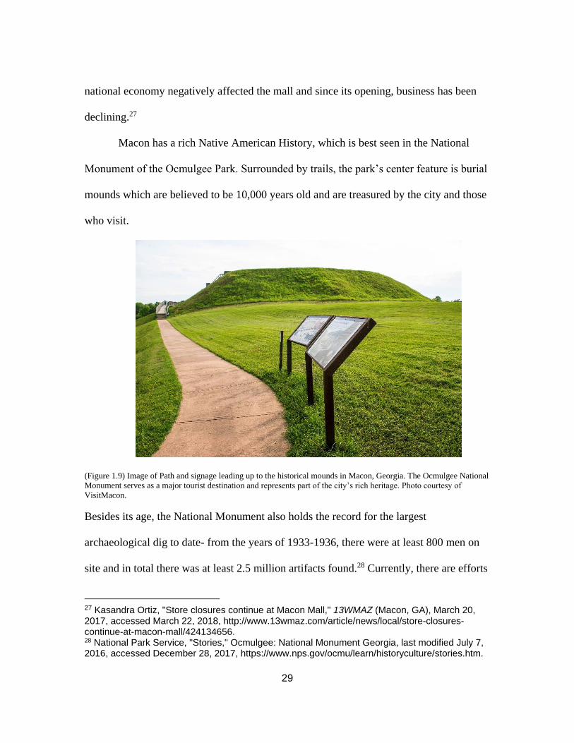
Macon has a rich Native American History, which is best seen in the National
Monument of the Ocmulgee Park. Surrounded by trails, the park’s center feature is burial
mounds which are believed to be 10,000 years old and are treasured by the city and those
who visit.
(Figure 1.9) Image of Path and signage leading up to the historical mounds in Macon, Georgia. The Ocmulgee National
Monument serves as a major tourist destination and represents part of the city’s rich heritage. Photo courtesy of
VisitMacon.
Besides its age, the National Monument also holds the record for the largest
archaeological dig to date- from the years of 1933-1936, there were at least 800 men on
site and in total there was at least 2.5 million artifacts found.28 Currently, there are efforts
27 Kasandra Ortiz, "Store closures continue at Macon Mall," 13WMAZ (Macon, GA), March 20, 2017, accessed March 22, 2018, http://www.13wmaz.com/article/news/local/store-closures-continue-at-macon-mall/424134656. 28 National Park Service, "Stories," Ocmulgee: National Monument Georgia, last modified July 7, 2016, accessed December 28, 2017, https://www.nps.gov/ocmu/learn/historyculture/stories.htm.

30
underway to not only expand the National Monument, but to have it listed under National
Park and Preserve status, making it the first preserve east of the Mississippi River and
the only National Park in Georgia.29
With all the efforts to revitalize, Macon has a lot going on. Today, Macon is a city
working towards revitalization under the guidance of Mayor Robert Reichert. In attempt
to downsize not only the government, but also government spending, in 2012, the city
government of Macon and the county government of Bibb County voted to be
consolidated. The consolidation was official at the start of 2014. Mercer University plays
a huge role in the streetscape and economy of the city, with plans to continue growing its
campus. All the medical facilities
serve as a huge draw for the
surroundings municipalities. In
addition to the medical facilities,
there are several museums and
music- oriented festivals in Macon.
GABBAfest is an entire festival
meant to honor the legacy of the
Allman Brothers Band and as a
non-profit organization, GABBA
29 Ocmulgee National Park & Preserve Initiative, "Welcome," Ocmulgee National Park and Preserve Initiative, last modified 2017, accessed December 28, 2017, http://www.ocmulgeepark.org/.
(Figure 1.10) Image of Otis Redding Statue in Gateway Park. Redding
was a native to Macon. Image courtesy of NewTown Macon.

31
has contributed to different restoration efforts around the city.30 Bragg Jam is another
annual music festival is sponsored by the city.31 In addition its musical heritage, Macon is
recognized as having the most cherry blossoms in the world. There is a two- week
festival every year to showcase the blooms.32 The festivals and natural/ cultural resources
have played a key role in the economy for many years. Even looking back to 2001, the
Chamber of Commerce reported that tourism was responsible for contributing over $300
million to the economy.33 Macon has a large amount of industry in its economy- both
mechanical and agricultural. The county still produces a large amount of peaches as it did
in the 19th century and produces many pecans. Besides its agricultural side, Kumho Tires
opened its first manufacturing plant in the US in Macon. Geico is another major
employer of the residents in the Macon-Bibb County.
30GABBA, "About GABBA," GABBA: Georgia Allman Brothers Band Association, accessed January 26, 2018, http://www.gabbafest.org/mission/. 31Gateway Macon, "Summer Festivals Overview," Gateway Macon, last modified 2018, accessed January 26, 2018, https://www.gatewaymacon.org/festivals-macon-ga/bragg-jam.cms. 32 Bozeman, Macon: Then & Now. 33 Tracy Maurer, Macon Celebrates the Millennium, Montgomery, AL. Community Communications, Inc. 2001.

32
METHODOLOGY
To answer the question of “who a city’s priority should be,” two studies with
different public policies were selected to be compared. Greenville, South Carolina was
selected due to its noteworthy success in revitalization. To better understand what led to
Greenville’s success, a comparison of its public policies to a similar city will explain
what Greenville did differently. The second case study was required to share
characteristics that impacted the city’s development as well as similar characteristics at
the start of its revitalization efforts to accurately the compare the two cities’ progress.
Recognizing the large impact of the New South movement on Greenville, it was logical
to choose another city that shared in the impact of the movement. Macon, Georgia is
another city that boomed with industry during the New South movement. Upon further
research, the two cities had many characteristics in common. The only major discrepancy
between the two was the current population size. However, from 1990- 2014 (the year of
Macon’s consolidation with Bibb County) the two maintained populations within the
range of 50,000- 100,000 people, making the comparison legitimate.
Upon selection of the case studies, the next step was to establish where to find
examples of the cities’ public policy. The strategy a city sets to achieve a goal is made
clear through the public policies that are adopted over the years. Comprehensive plans
often are the most in depth documents due to the range of topics that are discussed.
According to the code of law in South Carolina, the state government gives the
municipality the right to form a planning commission. The planning commission may
create a comprehensive plan that must include a discussion of topics like population,

33
transportation, housing, etc.34 Code of law in the state of Georgia states that not only are
municipalities allowed to create comprehensive plans, they are required to. There is not
set format of what should be included.35 Both cities have adopted comprehensive plans,
master, strategic, and preservation plans that dictate the goals the city is working towards
achieving. While the city governments are currently operating from these plans, there is a
level of idealism that comes along with the goals set and sometimes, these goals are put
on hold. Therefore, the analysis needed to include financial records to identify not only
what the city is spending money on, but also what is creating revenue for the city. The
time frame established for these documents was 1990-2017. This range should limit the
number of documents while still allowing thirty years of trends to be illustrated. These
trends will help identify shifts in public policy. Many public documents are available
online, but there are not enough documents online to cover the established time frame.
Therefore, another important element will be to visit the cities and collect onsite
observations. This context will provide better understanding while reading the plans and
reports. While onsite, there was an opportunity to visit the city offices and study copies of
documents that were not available online.
In addition to the context gathered from on-site visits, research will be required to
discover the histories of the cities and how they got to their current state. The research
will also indicate the factors that played a role in Greenville and Macon’s development.
34 Local Government - Provisions Applicable to Special Purpose Districts and Other Political Subdivisions, S.C. Code Ann. §§ 6-29-510 (1976 & Supp. 2017). 35 Larry Hanson, ed., Handbook for Georgia Mayors and Councilmembers, fifth ed. (Atlanta, GA: Georgia Municipal Association, 2018), 1, accessed April 26, 2018, https://www.gmanet.com/GMASite/media/PDF/handbook/planning.pdf.

34
A large portion of the information needed will be available online as historic newspapers,
books, photos and maps of the cities. In addition to the online material, the local libraries
have information that has not been digitized available, making onsite visits even more
important. While onsite, part of the process will include documentation and evaluation of
the streetscape. Recognizing this evaluation is an objective study, it still is important to
understand the functionality of a city while reading about its goals and various
expenditures. The elements to be evaluated are chosen from consistent elements
discussed in the literature dealing with revitalization strategies. These characteristics
include walkability, aesthetics, connectivity, transportation, and the variety of retail and
food on the main street. In terms of walkability, the evaluation is straightforward, can this
city be walked easily? The aesthetic aspect is also simple in that it is an evaluation of
how appealing the streetscapes are and their maintenance. Connectivity and
Transportation are two characteristics that are closely connected because the
transportation influences that level of connectivity within a city. Is it easy to travel to
places in or near the city? Does there seem to be a pattern that connects the main street to
the rest of the city? Finally, the variety of business downtown is an important
characteristic to note when evaluating a city. The different kinds of stores show what the
community has an interest in supporting and the number of storefronts serves as an
indicator of the overall economic success within the city. Below is a table to better
document the objective findings on-site.

35
Characteristics Poor Average Well done
Transportation
Variety of stores
Walkability
Aesthetic appeal
Connectivity
throughout city
(Figure 1.11) A chart created for onsite documentation in Downtown Greenville and Downtown Macon.
While onsite, an important part of the visits is to locate and study documents that
are not available online. To do this, it is necessary to contact members of the city
government to set up a time to come into the office and study the documents. The City of
Greenville has both comprehensive plans available onsite, as well as all the
Comprehensive Financial Annual Reports from the years 1990-2014. Macon has its
comprehensive plans from 1990-2013 available onsite, as well as the Preservation Plan
for Intown Macon Historic District. The remainder of the plans included in this thesis
were available online. While studying the different plans, the goals will be identified
through different elements of focus like population, housing, economic, cultural, natural
and transportation. The goals for each element are meant to improve its status, and with
overall improvement amongst all the elements, the city is expected to improve as well.
While every city hopes to improve, the question to be answered in the evaluation of this
plan is: who are these improvements for? The language used throughout the plans will

36
identify the target audience affected by the goals set- the residents or tourists. The plans
provide important insight into what is valued by the city and by the community.
Community values are included in most of the plans, allowing for comparisons to be
taken from what the city government wants and what the community wants. If the city
values the community contributions, there will be a direct correlation with the goals set
by the city and what the community sees as characteristics that need to be improved
upon.
To further support the information found in the plans, financial records will
confirm the goals that were invested in between 1990-2017. Law requires the
Comprehensive Annual Financial Reports to be annually published by municipalities in
both South Carolina and Georgia. This requirement enforces transparency by providing
citizens the ability to read about where their tax money is being spent. While studying
these reports, there should be trends that emerge over the years. Ideally, a growing
economy will experience higher business license revenue. Recognizing that both the
national economy heavily affects local economies, there will assumedly be dips in the
charts that do not serve as a representation of the overall status of the city. When the dips
occur at other times, that is noteworthy. For a city to be livable, there should be an
investment in parts of the city that most affect residents like public safety or sidewalk
expenditures. A city with the intention of becoming a destination will invest in more
departments like parks and recreation and large entertainment venues. The reports will
also be used when determining the current success achieved by the cities. A growing
economy will have experienced an increase in revenue from tax collections and business

37
licenses as well as an influx of new industry to the locality.
Through the study of documents and on-site observations, it is possible to draw
conclusions explaining what was different in Greenville’s public policy and why this led
to the success the city is experiencing today. The comparison of two cities with different
policy priorities indicates that the more successful strategy is to emphasize a reinvestment
in its citizens rather than the potential influx of tourists.

38
CHAPTER TWO
LITERATURE REVIEW
This literature review touches on the history of the two cities and the New South
movement that shaped both. A majority of the literature in this review is written about the
idea of placemaking, and two different revitalization strategies: tourism based or resident-
based schemes. Greenville, South Carolina and Macon, Georgia are two cities that began
the revitalization journey many years ago but pursued different strategies. Both
historically textile towns, Macon and Greenville approached placemaking differently, and
it affected the rate of both cities’ revitalization. Greenville County, formed in 1786 was
named for General Nathaniel Greene, and remained a small resort village until 1869,
when it was incorporated as a city. 36 Macon, Georgia was incorporated in 1823 and was
named for Nathaniel Macon.37 At the turn of the 20th century, both cities were
powerhouses for textile production. With the New South Movement after the Civil War,
industry took off in the southern states.38 This industry brought growth to Macon and
Greenville and the development of the cities as a whole. However, after World War II,
the new boom of suburbs tempted people looking for a “better life” outside the city. With
36 City of Greenville, SC. "The History of Greenville." City of Greenville, South Carolina. Accessed September 19, 2019. http://www.greenvillesc.gov/DocumentCenter/View/1317. 37 State of Georgia. "Macon." GEORGIAGOV. Accessed October 14, 2017. https://georgia.gov/ cities-counties/macon. 38 While the New South Movement serves as a connection for the two cities in question, it will not be discussed in great length for this thesis. It was a movement occurring in the reconstruction era of United States history in the southern states that pushed for increasing industry to replace the almost exclusively agricultural economy. Henry Grady wrote about the condition of the New South in 1890.

39
the large exodus of people, the cities suffered, and by the 1970s, Macon and Greenville
were in disrepair.39
To better understand the revitalization process, there is a need to gather literary
context. There is considerable literature dealing with placemaking in cities. Over the past
30 years, there has been many success stories of fading downtowns becoming revitalized
centers. While utilizing different strategies, these urban environments share a common
goal- to create a place people want to be. This goal is the epitome of “placemaking.”
“Placemaking” is a philosophy that can be spelled three different ways and has never
been officially defined. The lack of clarity over what it is or even how it is spelled is a
good indicator that cities all approach the idea of “placemaking” differently. Placemaking
as a philosophy has been around for many years, with people like Jane Jacobs writing
about the importance of it to the health of a city and its people.40 She is not alone in her
writing and since her publication of The Life and Death of Great American Cities, there
has been extensive literature and statistics documenting the effects of placemaking. Jeff
Speck’s Walkable City discusses the many benefits that come with creating an urban
environment that people can walk around. Part of achieving this goal is by not only
creating places for pedestrians to walk, but by making their walk interesting. The
Handbook of Biophilic City Planning and Design, by Timothy Beatley41 specifically talks
39 On page 114 of Cities on the Rebound, William Hudnut offers statistics about the percentage of people who moved out of the city to a suburb. “Between 1970 and 1997, suburban family growth outpaced that of cities by a ratio of 5 to 1.” 40 Jane Jacobs, The Death and Life of Great American Cities, New York, NY: Vintage Books, 1992. 41 Timothy Beatley, Handbook of Biophilic City Planning and Design, Washington, DC: Island
Press, 2016.

40
about creating greenspaces within an urban environment as a part of the overall
placemaking. He emphasizes the need for greenspace in urban places. In addition to
greenspaces, Stephanie Meeks42 writes in her book, the Past and Future City, about the
importance of diversity in a place. Whether it is the businesses, the architecture, or the
people who make up an urban setting, diversity plays a key role in the overall health of
the city.43 Knowing all these different characteristics of a place is the starting point. The
next step is establishing how to go about creating a place.
So, how does a city recreate its identity, making the city a place? There is plenty
of literature explaining what characteristics make up the ideal city, the challenging part is
creating a plan that gets a city to the ideal level. Especially in mid to small sized cities,
funding is not immediately available for drastic improvements to the streetscapes, and the
local government must create a plan to meet their goals. Typically, this plan is laid out in
what is most commonly referred to as a Comprehensive Plan. A comprehensive plan
functions as a guide for a city’s future- it lays out desired goals, the steps that need to be
taken in order to achieve them, and it also provides a time period in which all of these
goals are to be met.44 Each city formulates their own plan, and due to the unique needs
for each locality, there are many strategies that a government can pursue to achieve their
42 Stephanie Meeks is the current President and CEO of the National Trust for Historic Preservation. The National Trust is a nonprofit organization that was founded in 1949. Based in DC, the organization has offices and protected structures all over the United States. National Trust for Historic Preservation. "We Are Saving Places." National Trust for Historic Preservation. Accessed October 11, 2017. https://savingplaces.org/we-are-saving-places#.Wekf8GhSxPZ. 43 Stephanie Meeks and Kevin C. Murphy, The Past and Future City (Washington, DC: Island Press, 2017). 44United States Cooperative Extension System. "The Purpose of the Comprehensive Land Use Plan.” extension. Last modified December 9, 2015. Accessed October 12, 2017. http://articles.extension.org/pages/26677/the-purpose-of-the-comprehensive-land-use-plan.

41
placemaking goals. Of these different strategies, they can be categorized by the priorities
emphasized. One approach is to build a place that is meant to be enjoyed by tourists and
caters to the tourism industry of a city’s economy. Books like Tourism Planning by Clare
Gunn; The Development & Management of Visitor Attractions by John Swarbrooke;
Tourism Planning by Edward Inskeep, and many others, provide helpful information and
guidance for strong tourism planning.454647 It is notable, however, that a large amount of
the literature pertaining to planning based on tourism is older. In more recent
publications, there has been a strategy that approaches placemaking not from the angle of
tourism, but by making a place that is designed around the people that live in the city.
Smart Growth America and the Urban Land Institute are two private entities in the United
States that advocate the goal of creating a better experience for the resident of any given
city- “community- based planning.” Next, this literature review will cover sources that
discuss both strategies and their strengths once applied.
“With the weakening of many other aspects of the economy, nations and
communities see tourism as a quick and easy solution.”48 Tourism is a market that is
extremely profitable in places all over the world. By creating a city that people want to
visit and explore, this revitalization strategy is often employed by midsized towns hoping
to quickly generate revenue. There are different ways to make a place worth visiting. In
45 Claire A. Gunn, Tourism Planning: Basics, Concepts, Cases, Third, Philadelphia, PA: Taylor & Francis, 1994. 46 John Swarbrooke, The Development and Management of Visitor Attractions, Oxford, UK: Butterworth & Heinemann, 1995. 47 Edward Inskeep, Tourism Planning: An Integrated and Sustainable Development Approach, New York, NY: Wan Nostrand Reinhold, 1991. 48 Claire A. Gunn, Tourism Planning: Basics, Concepts, Cases.

42
Creating Vibrant Public Places, Ned Crankshaw discusses various aspects of historic
districts.49 With discussions of not only the layout, but also the authenticity of a historic
district, he explains the overall positive effect a historic district could have on a
community. Places like Charleston, New Orleans, and Savannah have all seen success by
enhancing historic districts in an effort to attract visitors. These historic districts have
adopted “stringent physical design controls” in order to maintain their tangible
resources.50 Controlling the design of a place forces the city to preserve some original
fabric, separating it from other cities different historic fabric. The idea of utilizing
tangible elements in the New South is discussed in extensive detail in the book Designing
Dixie, Reiko Hillyer writes about the effect of redesigning of the South during
reconstruction and the usage of tourism in its industry. He asserts that utilizing this
tangible, romantic history is the reason for the boom of the Southern economy post- Civil
War.51 The article “Character is Key to an Economically Vibrant City” echoes this
assertion by saying, “The more a city does to enhance its uniqueness, whether that is
cultural, natural or architectural, the more people want to visit.” However, there is a fine
line that cities working towards becoming a tourist destination must walk. It is important
to maintain the unique character, but this should be balanced with a sense of familiarity.
The article, “Tourism Planning and Place Making” elaborates on the idea of tangible and
intangible resources and their relevance to the planning. The tangible resources are what
49Ned Crankshaw, Creating Vibrant Public Spaces: Streetscape Design in Commercial and Historic Districts, Washington, DC: IslandPress, 2009. 50 Alan A. Lew (2017) “Tourism planning and place making: place-making or placemaking?”, Tourism Geographies, 19:3, 448-466, DOI: 10.1080/1461688.2017.1282007 51 Reiko Hillyer. Designing Dixie: Tourism, Memory, and Urban Space in the New South. Charlottesville, VA: University of Virginia Press, 2014.

43
is visible to visitors and the intangible resources are the unique identity and feeling
experienced in the place they are visiting. Alan Lew also discusses the idea of tourism
planning and the need for visitors to feel a sense of familiarity with wherever they
are.52This familiarity can be developed through chain stores or signage- an idea also
touched on in the book Cities Back from the Edge53 and Creating Vibrant Public
Spaces.54
Finally, tourism planning always involves one element. It is important for a city to
create something within the downtown that is worth tourists coming to visit at least once-
a destination. Many have adopted a “silver bullet” strategy. The “Silver bullet” is a
community constructing one major project and thinking that will be the answer to their
revitalization problems.55 Creating a silver bullet is adopting the mindset that this one
destination will save the city. In terms of revitalization, a silver bullet can be a music
venue, like those sponsored by the Levitt Foundation.56 There has been a recent trend in
revitalization focusing on the arts- specifically in Music Festivals, like the one in Austin,
Texas called Austin City Limits.57 Other silver bullets manifest themselves in permanent
52 “Character is Key to an Economically Vibrant City” 53 Roberta Brandes Gratz, and Norman Mintz, Cities Back from the Edge, New York, NY: John Wiley & Sons, Inc., 1998. 54 Ned Crankshaw, Creating Vibrant Public Spaces: Streetscape Design in Commercial and Historic Districts. 55 Dolores P. Palma, "Downtown Revitalization Myths," Illinois Principal Review, July 1995, 22, accessed March 22, 2018, http://www.lib.niu.edu/1995/im950719.html. 56Lee, Sarah, Peter Linett, Nicole Baltazar, and Joanna Woronkowicz. Setting the Stage for Community Change: Reflecting on Creative Placemaking Outcomes. Chicago, IL: Mortimer & Mimi Levitt Foundation, 2016. 57 Greg Richards. (2017) “From place branding to place-making: the role of events”, International Journal of Event and Festival Management, Vol. 8 Issue 1, pp. 8-23, https://doi.org/10.1108/IJEFM-09-2016-0063

44
forms like the Carousel in Mansfield, Ohio.58 According to Hudnut, the carousel resulted
in great success overall to the revitalization of this small town. Whether it is a giant arena
for sports and events, a perfectly preserved colonial town like Williamsburg, or even just
a mall- creating a place that people will visit and tell others to visit is often a strategy
utilized by cities in the process of re-planning or designing their city.
“Once people know they can have a voice, they demand it.”59 William Hudnut III
begins a chapter of his book, Cities on the Rebound, with these words. As the Mayor of
Indianapolis during its major revitalization drive, Hudnut explains in his book the steps
he believed each town should follow in their revitalization strategy. A major point he
emphasizes is that a city needs to listen to its residents. This means that investments
should be made in what changes are best for the population- whether it is new roads,
saving local businesses, protecting historic resources, or anything else- a city government
should make the downtown a place people want to live. Placemaking: The Art and
Practice of Building Communities is a book that includes three different instances of
placemaking intended for the betterment of the people living within a community.
Following the entire process of the efforts, the authors illustrate steps that a city can take
to create an environment designed for the citizens.60 The earlier years of urban planning
“focused on expansion on a large to protect businesses and the economy rather than being
concerned with livability for citizens.”61 The article, “The Revival of Placemaking” is
58 Hudnut III, William H. Cities on the Rebound: A Vision for Urban America. Washington, DC: Urban Land Institute, 1998. 59 Hudnut III, William H. Cities on the Rebound: A Vision for Urban America. 60 Lynda H. Scheekloth, and Robert G. Shibley, Placemaking: The Art and Practice of Building Communities, New York, NY: John Wiley & Sons, Inc., 1995. 61 Mary Ann Pascucci, "The Revival of Placemaking" Creative Nursing 21, no. 4 (2015): 200-05.

45
from a nursing journal and it discusses the relationships of cities and the health of its
residents. By planning around the residents, a city benefits them on a health level. The
consideration of the health of residents in the comprehensive planning process is an idea
fully endorsed by Jeff Speck in his book, Walkable City.62 The layout of city and
inclusion or widening of sidewalks not only encourages less cars on the road, but also
encourage more people to exercise in their daily life.63 However, there are cities that are
just too spread out and require a citywide transit system. Rebuilding the American City
has a section that discusses the commitment to improve infrastructure within a city, and
one chapter is about the Atlanta Beltline. This massive undertaking would dramatically
change the number of people in and out of the city everyday as well as the overall
accessibility of the 45 neighborhoods to the public spaces in Downtown Atlanta.64
Some of the literature pertaining to revitalization puts its residents first has been
about the overall layout and transportation in a city. While it is a very important aspect, it
is not the only characteristic to consider for community-based planning. There are many
different methods to go about establish what residents desire from their cities. William H.
Whyte’s book, The Social Life of Small Urban Spaces, is a compilation of photographs
that he analyzes and uses to explain trends of residents in New York City. Whyte
explains simply, that “What attracts people most, it would appear, is other people.”65 The
62 Jeff Speck, Walkable City: How Downtown Can Save America, One Step at A Time, New York, NY: A Division of Farrar, Straus Giroux, 2012. 63 Jeff Speck, Walkable City: How Downtown, 64 David Gamble and Patty Heyda, Rebuilding the American City: Design and Strategy for the 21st Century Urban Core, New York, NY: Routledge, 2016. 65 William H Whyte, The Social Life of Small Urban Places, Washington, DC: The Conservation Foundation, 1980.

46
idea of other people and interconnectedness is again discussed by Hudnut, the former
mayor of Indianapolis.66 Interconnectedness creates a community, but there is more that
goes into creating a place designed for residents. This point is reinforced in Happy City,
when Charles Montgomery recounts his conversation with the Mayor of Bogota, Enrique
Penalosa. The mayor explained “We need to walk, just as birds need to fly. We need to
be around other people. We need beauty. We need contact with nature…”67
Another aspect of improved downtown living that has been proven through
statistics (Resilient Downtown and Past and Future City provide many numbers) is that
historical context of a city is important to its residents. 68 There are ways of maintaining
this historical context and the most efficient way is establishing codes that protect them-
specifically guidelines.69 All of these numbers provide support to the assertion of Jane
Jacobs- “Cities need old buildings so badly it is probably impossible for vigorous streets
and districts to grow without them.”70 For many developers, the idea of following the
guidelines for historic districts is a deterrent and would rather construct new buildings
outside of the districts, but there is literature that asserts the reuse of buildings is more
cost effective than new construction.71 In addition to the cost efficiency, Stephanie Meeks
says that many people and offices prefer the adaptive reuse of old buildings for their
66 William H Hudnut III, Cities on the Rebound: A Vision for Urban America. [page 136]. 67 Charles Montgomery, Happy City: Transforming Our Lives Through Urban Design, New York, NY: Farrar, Straus and Giroux, 2013. Pg. 6. 68 Michael A Burayidi, Resilient Downtowns: A New Approach to Revitalizing Small- and Medium- City Downtowns, New York, NY: Routledge, 2013 69 Mary E. Madden, and Bill Spikowski. "Place Making with Form-Based Code," Urban Land, September 2006, 174-78. 70 Jane Jacobs. The Death and Life of Great American Cities, 187. 71Storm Cunningham, The Restoration Economy, San Francisco, CA: Berrett-Koehler Publishers, Inc., 2002.

47
current needs than a new buildings. She backs this up by explaining that the reuse allows
for a connection to the past of the city, creating a deeper connectedness with the
community today.72 While the aesthetic and overall nostalgia created by a downtown
plays a large role in the lives of its residents, there is one utilitarian element to make the
city livable. The city government should be housed downtown for easy access. Resilient
Downtowns discusses the importance of maintaining and revamping these government
buildings as a way of bringing people and their business to the city center.73
There is one revitalization trend that is benefits both the tourism industry and the
residents. Efforts that are meant to revitalize local waterfronts have seen great success
over the years, with many examples being in the Southeastern states. By creating a
waterfront park, the city defines a space that is meant to provide its residents with natural
beauty, and a place to gather. It is important “to appeal to people of many ages, incomes,
and ethnic backgrounds”74 because people from all walks of life will be visiting the
waterfront- whether they are residents or tourists. In terms of tourism, by utilizing the
waterfront, cities create a destination that not all cities can offer, making it a desirable
tourist spot. Cities like Savannah, GA have revamped their natural resources and created
river walks for visitors. The river walk in Savannah is lined with restaurants and souvenir
stores designed specifically for those visiting the city. Chattanooga, TN is another
noteworthy example of a river walk that created a destination for visitors. The process of
72 Stephanie Meeks and Kevin C. Murphy, The Past and Future City. 73 Michael A. Burayidi, Resilient Downtowns: A New Approach to Revitalizing Small- and Medium- City Downtowns. 74Lance Jay Brown, David Dixon, and Oliver Gillham, Urban Design for an Urban Century: Placemaking for People, Hoboken, New Jersey: John Wiley & Sons, Inc., 2009. Pg. 17.

48
building it was fast and that speed coupled with the political and design process, very
impressive.75 The 13-Mile river walk is the first item listed on the Chattanooga City
website for things to do, emphasizing the role it plays in the tourism industry of
Chattanooga.76 While these waterfront revival schemes play a huge role in cities as a
tourist destination, other cities revitalize their waterfront to better serve their residents.
The Handbook of Biophilic City Planning and Design tells the story of three different
riverfront revitalizations: the Los Angeles River, Los Angeles, CA; the James River,
Richmond, VA, and the St. Louis River Ring, St. Louis, Missouri.77 The bottom line is
that no matter what the strategy is being used for revitalization, a city with a riverfront
should always take advantage of its geography.
75 David Gamble and Patty Heyda, Rebuilding the American City: Design and Strategy for the 21st Century Urban Core. 76 City of Chattanooga. "Things to Do in Chattanooga." Chattanooga: Best Town Ever. Accessed October 4, 2017. https://www.chattanoogafun.com/things-to-do/. 77 Timothy Beatley, Handbook of Biophilic City Planning and Design.

49
CHAPTER THREE
GREENVILLE, SC
Public policy can be identified through publications of the city government.
Having been approved by the representatives, the publications provide an explicit
representation of the city’s intentions. To evaluate Greenville, this chapter will analyze
five city documents that were adopted between the years of 1990-2017. The first plan
included in this chapter is the Land Design/ Research Inc. from 1989, Downtown
Development Strategy. This summary is followed by an assessment conducted by the
same firm in 1997. In 1999, the Greenville adopted a comprehensive plan, which is
included in the analysis. Moving forward ten years, the next plan is the Sasaki &
Associates Master Plan which was adopted in 2008. Finally, the current comprehensive
plan from 2009, which is titled Plan-It Greenville and was updated in 2014, is the last
plan included. Following the selected summaries, the chapter continues with analysis of
the goals set throughout the years and then supported with the findings in the
Comprehensive Financial Annual Reports.
The plans included are meant to provide an overview of the goals for the entire
city. There are many plans Greenville has published over the years but were not included
in this section. In order to analyze citywide revitalization, only the plans covering “big
picture” goals are included. Many city plans will typically begin with community input
and move on to city staff/ professional evaluation. Each plan sets a list of
recommendations that will improve the quality of life in Greenville. With different
groups in the community represented, a final plan should represent the needs for every

50
group, creating a balanced living environment. To support the objectives set in the plans
and to monitor the progress that follows their adoption, the Comprehensive Annual
Financial Reports will be included in the analysis. After the summarization of the plans,
there will be a section that will look at the Comprehensive Annual Financial Reports to
compare the goals of the plans versus the initiatives in the reports.
PLANS AND STRATEGIES
Land Design/ Research Inc. Reports
In 1989, Greenville asked the Land Design/Research Firm (LDR) to conduct a
session with the public and create the Downtown Development Strategy.78 This process
included gathering public opinion about the status of the urban core. The responses
gathered listed positive and negative aspects of downtown Greenville. After the public
opinion section, LDR continued to identify a strategy with their professional analysis and
recommendations. Some of the recommendations included different goals that were set to
be met after 90 days, in 1-2 years, or in five years. A particularly important distinction
made in this report is the definition of a successful downtown. Contrary to the popular
notion that a successful city had many office buildings filled with people, LDR asserted
that a successful downtown is one filled with people and activities.79 LDR made the
78 Land/Design Research Inc. was a planning firm operating out of Columbia, MD. The firm offered services like urban and digital design, land planning, growth management, and strategic assessment. As of 2000, the firm was included under the umbrella of the HNTB Corporation. https://www.bloomberg.com/research/stocks/private/snapshot.asp?privcapId=667371 79 Land Design/Research, Inc., Downtown Development Strategy, Greenville, SC: City of Greenville, April 1989, [page 9]. Accessed March 19th, 2018. https://www.greenvillesc.gov/DocumentCenter/View/6511

51
recommendation that Greenville should encourage mixed use developments with focus
on Main Street, which they referred to as the “activity spine.”80 Following its vision for
Main Street, the strategy continued to highlight other major projects that Greenville could
pursue. Two of the projects were developing the Reedy River and expanding the
Coliseum. Again, LDR said these projects should be oriented towards Main Street to
encourage the connectivity of the downtown. The only mention of tourism that is made in
this strategy is identifying the opportunity at the Reedy River for a planned open space.
From the beginning, the Reedy River was acknowledged as potentially being the main
attraction for Greenville, a feeling that is echoed in the book Reimagining Greenville,
which was referenced in the first chapter.81
A follow-up to the 1989 report was requested by Greenville and so LDR returned
to downtown in 1997 to assess what had been accomplished and again offer advice for
the next steps. This report began again with an explanation of the steps taken to formulate
the report, which included a list of questions for the volunteer community members who
were participating in the report to answer. LDR continued with a summary of goals that
were set in the 1989 report and dictates which have been met, are in progress, or are no
longer being pursued. The most important part of this report is that LDR identified the
challenges Greenville experiences. LDR states that these challenges should be given high
priority and included in a strategic plan to be accomplished by 2001. Some challenges
included: creating an identity for Greenville; encouraging more retail to move downtown;
80 Land Design/Research, Inc., Downtown Development Strategy, 11. 81 Boyanski, Reimagining Greenville, 30.

52
the public and private sectors working together to fund projects; increasing amount of
housing downtown. Interestingly, the report asserted that Greenville needed to create an
attraction for tourists to visit, citing examples like the Macon Music Hall of Fame.
However, in the conclusion of this section, six of the challenges were given priority: First
Annual Downtown Report Card Forum; working together more effectively; retail
development; housing development; downtown as everyone’s neighborhood; expand
downtown’s management capacity.82
Downtown Master Plan: Sasaki & Associates 2008
There was a master plan published for the downtown commercial district in June
2008 by the firm, Sasaki & Associates.83 The planning process began in February 2007
and culminated over a year later. During the year, Sasaki met with key contributors to the
downtown community, including business owners, residents, and city officials. This plan
outlined three overarching goals for the Greenville: To Position Greenville, Making
Connections and Move Beyond Main Street.84 In order to “position Greenville”, the city
needed to take advantage of the multiple resources available (cultural, natural,
educational) and create a place with mixed uses. The goal of making connections
82 Land Design/Research, Inc., Report Card and Strategic Assessment, Greenville, SC: City of Greenville, February 1997, Accessed March 19th, 2018, https://www.greenvillesc.gov/DocumentCenter/View/6512 83 A design firm first founded by Hideo Sasaki. With offices in Boston and Shanghai, the firm’s mission statement is “We transcend the boundaries of traditional disciplines in pursuit of singular, interconnected visions for campus and urban environments that advance the contemporary human experience.” Sasaki Associates, Inc, "About Us," Sasaki, Accessed March 19, 2018, http://www.sasaki.com/ about-us/. 84 Sasaki Associates Inc., Downtown Greenville Master Plan, Greenville, SC: City of Greenville, June 2008, 7. Accessed March 19th, 2018. https://www.greenvillesc.gov/DocumentCenter/View/283
53
explained that the Greenville needed to be better connected and should improve
architecture and walkability. This went hand in hand with the final goal- moving beyond
Main Street. Essentially, the Sasaki firm asserted that the focus of revitalization needed to
move past Main Street and look for opportunities in new gathering places.85
The goal of positioning Greenville was the first chapter in the master plan. To
begin with, the chapter highlighted the progress Greenville had made in job creation by
comparing it to other cities like Chattanooga, TN and Asheville, NC. Sasaki recognized
that while there has been growth, more growth was necessary: “Having made many
strategic public investments, the focus should now be on leveraging more fully the
private sector investment in downtown.”86 Private sector investment was referring to
more local businesses being located downtown whether it was big offices or small
specialty shops. A part of the private sector investment included emphasizing Greenville
as a “cultural and arts hub” and this reputation, would make Greenville more than just a
local destination, but a national one.87 In addition to the recommendation to create a
visitor destination, the master plan also recommended the presence of higher education
within the boundaries of Greenville as an another way to put the city on the map.
The plan continued with the goal of “positioning Greenville.” Part of positioning
Greenville meant controlling how buildings downtown were being used. While
discussing residential occupancy, the plan recommended targeting “young singles and
couples, empty-nesters and retirees, small families and non-traditional families.” This
85 Sasaki Associates Inc., Downtown Greenville Master Plan, 7. 86 Sasaki Associates Inc., Downtown Greenville Master Plan, 17. 87 Sasaki Associates Inc., Downtown Greenville Master Plan, 17.

54
recommendation was followed up with the recommendation that rent prices should be
suitable for people who work downtown or make in the $35,000-$75,000 a year range.
The goal was to encourage more people to live where they work.88 Besides
recommending target residents for downtown, the plan also identified what industries
should be targeted to occupy the office buildings. Information, financial services and
professional and business services were the industries recommended. The master plan
said that to attract these type of industries, Greenville needs to make itself more
appealing as a place to live. Improvements like making a downtown walkable or creating
places employees can live within walking distance of their offices are major attractions
for potential industry.89 With higher occupancy rates, more retail variety should be
encouraged as a way to keep retail business downtown. The plan recommended that the
four groups to target for retail business is: downtown residents, downtown employees,
visitors, residents who live within ten minutes. The group expected to contribute the most
was the residents who lived within ten minutes.90
Sasaki listed improving the connectivity of the city as one of the guiding themes
to improve Greenville. This theme had goals that were built around five principles:
1. Expand to five corners of downtown
2. Create a green necklace
3. Celebrate the points of arrival
4. Tame the roads
5. Create a linked transportation network
88 Sasaki Associates Inc., Downtown Greenville Master Plan, 19. 89 Sasaki Associates Inc., Downtown Greenville Master Plan, 20. 90 Sasaki Associates Inc., Downtown Greenville Master Plan, 22.

55
The downtown needed to be connected to not only the different parts of the city but also
the areas right outside of downtown. By improving the connectivity, the city would
experience more traffic on a daily basis. To begin improving connectivity, Sasaki
identified the five corners in Greenville that need to be better connected to the heart of
the city. This plan recommended that these five corners, which were then “characterized
by open parking lots and largely underutilized urban land,” should create individual
identities and provide activities for people off of the Main Street mile.91 Another
recommendation to improve Greenville’s connectivity was the construction of a visitor
center in the Broad & River Street Neighborhood.92 A caveat in connecting all of
Greenville and continue pushing development past Main Street was the need to improve
the transportation in and around the city. This improvement included an expansion of the
trolley system in the immediate downtown area as well as establishing a route with
Greenville Transit Authority In addition to transportation, the Sasaki firm advised that the
city take full advantage of the parking it had available.93
There was an implementation strategy included in this plan which summarized the
goals set in the chapters as well as identified the parties responsible for initiating the
projects. The strategy operated under two policy initiatives: comprehensive marketing
and recruitment and changing the approval processes. Simply put, the city and private
91 Sasaki Associates Inc., Downtown Greenville Master Plan, 33. 92 Sasaki Associates Inc., Downtown Greenville Master Plan, 40. 93 Sasaki Associates Inc., Downtown Greenville Master Plan, 55.

56
sector needed to focus on attracting people and industry to the city and the approval
process needed to be streamlined to make the development goals clear to the public.94
1999 Comprehensive Plan
The 1999 comprehensive plan began with a basic definition and purpose.
According to this document, a comprehensive plan was simply an expression of how a
city views its current situation and states the goals to be met in the future. The
introduction to this plan included the statement of purpose, which was summarized into
three parts. Firstly, a plan was required by state law and should be updated every five
years. Secondly, it established an “overall framework for coordinating both public and
private development.” Thirdly, an updated comprehensive plan was “evidence of the
City’s commitment to planning for its future on a continuing basis.”95 The planning
process section explained that the 1999 plan was set up as a neighborhood- based plan.
Each neighborhood was studied by the planning commission and efforts were made to
include community opinion. Surveys were conducted to identify the concerns of the
citizens as well as town meetings to allow citizens to voice their opinions.96 At the end of
the information gathering phase, there was a list of fundamental goals established by the
city.97 The plan was broken into chapters about the different topics the plan would
address. The first chapter was about the Land Use Element, followed by a chapter about
the Population Element, and then chapters about the Economic Element, the Housing
94 Sasaki Associates Inc., Downtown Greenville Master Plan, 59. 95 City of Greenville, Greenville South Carolina Comprehensive Plan, Greenville, SC: City of Greenville, 1999, 11. 96 City of Greenville, Greenville South Carolina, 14. 97 City of Greenville, Greenville South Carolina, 15.

57
Element, the Cultural Resource Element, the Natural Resource Element, and the last
chapter was about the Community Facilities Element.
Before stating the goals of future land use, the plan explained the breakdown of
the existing land and its uses. For example, about 31.4% of the acreage in Greenville was
in the land use category of single-family residential. This use was the most common,
followed by roads and paving at 17.2%. At the time of this plan, the total land use for
public purposes was 27.3%.98 According to the report, 61% of the land in the city was
zoned for residential purposes, however there were three districts that were zoned as
planned development districts. These districts allowed the city some flexibility in what
could be built there, especially in terms of infill.99 The discussion of infill development
led to a list of goals that encouraged development but also encouraged the preservation of
established neighborhoods.100 The plan divided the city into six planning zones, each with
goals specified to that zone. This chapter ended with a restatement of the six citywide
land use goals along with the time frames for when the goals would be accomplished and
the organizations/departments responsible for ensuring these goals were met.101
The Population Element chapter provided a quick snapshot of the population
statistics in the Greenville at the time this was written. This chapter did not necessarily
list goals that should be met in the future but provided context to explain who would have
been affected by the improvements made.102 After the brief population element chapter,
98 City of Greenville, Greenville South Carolina, LU-1. 99 City of Greenville, Greenville South Carolina, LU-2. 100City of Greenville, Greenville South Carolina, LU-5. 101 City of Greenville, Greenville South Carolina, LU 11-16. 102 City of Greenville, Greenville South Carolina, P-6.

58
the plan continues with a chapter dedicated to the economic element. There was a
detailed history about industry in Greenville and continued with census statistics from
1970-1990. These statistics identified who was employed and what industry they were in.
The city was also interested in the level of education reached by the employees, and in
total, how many people worked.103 The plan included a list of industries that employed
the people in Greenville. Some of the major businesses (within city limits) referenced
were: Fluor Daniel, BellSouth, the Greenville Hospital System, Duke Energy, Piedmont
Gas, Hitachi, BB&T, and Insignia Financial Group.104 However, even with all these
employers within downtown and or right outside the boundaries of the city, the commute
times for the average downtown resident still increased between 1980 and 1990, which
made the need for more employment opportunities downtown apparent.105 The plan
pointed out that the average income for a household almost doubled from 1970-1990 and
with the construction of new residential developments and the constant activity of the
downtown, it was guaranteed to continue increasing.106 At the end of the chapter there
were goals set and a list for who is in charge of pursuing them. The goals were:
1. Develop and administer initiatives designed to attract and retain businesses in the city.
2. Reserve funds to facilitate economic development through public investment.
3. Promote a diversified local economy in the Greenville Area.
4. Improve the quality of life while still encouraging economic development.
5. Continue the revitalization of downtown.
6. Strengthen commercial corridors.
7. Encourage residential development through the city.
103 City of Greenville, Greenville South Carolina, E-1. 104 City of Greenville, Greenville South Carolina, E-7. 105 City of Greenville, Greenville South Carolina, E-8. 106 City of Greenville, Greenville South Carolina, E-10.

59
The next chapter was about housing in Greenville. Beginning with context, the
plan stated that the population of Greenville in 1999 was 61,751 and had an average
density 2,433 people per square mile.107 Between the years of 1991 and 1997, there were
over 15,000 single family permits issued in the county, and the city only experienced
5.8% of the new building in the county.108 The data included in the plan made the trend
of increasing rent costs and ownership in living spaces apparent. There was one table
included that listed the average sale prices for houses between 1983-1997. The average
sale in 1983 was $63,109, and then in 1997 it was $133,606. This increase forced a
situation of less ownership and more rented properties.109 After addressing these trends,
the plan explained some of the issues that create challenges for affordability like policy
issues, racial disparity, condition of structures and conditions of the city.110 Continuing
with the issues of the current housing system, the plan identified different affordable
housing locations and the potential negative effects the residents in there units could
experience. Many hazards were caused by lead paint hazards and other structural
inadequacies. In addition to addressing the issues of homelessness in the city, the plan
addressed the target areas for the development of the downtown housing market. This
chapter also concluded with a list of goals that dealt with preserving neighborhoods,
creating quality infill, eliminating blight, overcoming affordable housing barriers, and
encouraging downtown housing options.111
107 City of Greenville, Greenville South Carolina, H-1. 108 City of Greenville, Greenville South Carolina, H-3. 109 City of Greenville, Greenville South Carolina, H5-8. 110 City of Greenville, Greenville South Carolina, H9-13. 111 City of Greenville, Greenville South Carolina, H46-48.

60
The next two chapters of the 1999 plan were about the Cultural and Natural
Resources in Greenville. In terms of cultural resources, the plan went into detail about the
historic preservation efforts and the value it created for the city.112 The need to encourage
visual arts and performance in the city was listed as a goal and the creation of
organizations that supported resources, like local groups, schools, theaters, and museums
was also encouraged.113 The plan also emphasized the need to better express the heritage
of Greenville through education, recreation, and religious activities.114 Goals to promote
the cultural resources in Greenville included funding for performing arts, creating
preservation effort awareness, and increase the amount of art available to residents.115 In
regards to Greenville’s natural resources, the plan went into great detail about the natural
characteristics of Greenville like its climate, geology, land, soils, fauna and flora, water
quality and the air quality. There was also a list of hazards that could affect that natural
resources in Greenville..116 The plan identified different natural spaces in the city that
could be sites of future design like the Cleveland Park West, Riverplace, Falls Historic
Park, Woodland Park and Cleveland Park East.117 Overall, the city goals listed in this
plan were: implement portions of the Reedy River Vision Plan, Develop Open Spaces
Preservation program, improve air and water quality, and improve tree protection.118
112 City of Greenville, Greenville South Carolina, CR 1-4. 113 City of Greenville, Greenville South Carolina, CR 7-11. 114 City of Greenville, Greenville South Carolina, CR 12-16. 115 City of Greenville, Greenville South Carolina, CR 17-20. 116 City of Greenville, Greenville South Carolina, NR 1-10. 117 City of Greenville, Greenville South Carolina, NR 11-12. 118City of Greenville, Greenville South Carolina, NR 18-20.

61
The final section of the 1999 Comprehensive Plan was about community facilities
in Greenville. According to this plan, community facilities included: the infrastructure;
water supply, treatment and distribution; the sewer system; solid waste collection and
disposal, and the public works (electric power, natural gas, telephone service).119 Another
element of the community facilities was the public welfare which included police, fire,
medical facilities, municipal facilities and recreation facilities. The final community
facility included in this section was the education system. To explain the city’s
relationship with education, it began by describing the school district and board of
trustees. Then, it listed future plans for the education system as well as the institutions of
higher learning. As in each section before it, the community facilities element section
ended with a list of goals and who was expected to achieve them. There were goals set to
improve transportation, water and sewer maintenance, solid waste, fire protection, police
protection, medical services, library system, education, and recreation.120
Plan-It Greenville
The current comprehensive plan of Greenville, South Carolina was first adopted
and published in 2009. Then again in 2014, per the legal requirement, Plan-It Greenville
was updated. Firstly, Plan-It Greenville plan began with an explanation of the process
that was used by the planning commission. The commission was interested in gathering
public opinion to ensure that public interests were represented in the goals. So, before any
research was started, the commission alerted the public that the planning process was
119 City of Greenville, Greenville South Carolina 1-6. 120 City of Greenville, Greenville South Carolina, CF 24-33.

62
beginning.121 Meetings and surveys were announced to give the community opportunities
to have their opinions heard. After the initial community outreach, next step was to
identify trends in the population, economy, education, overall growth and other factors
that affect the current community through information gathered through the surveys and
research.
The city representatives continued to meet with Greenville residents in different
workshops, focus groups, surveys, district meetings, and even in schools to discuss
improvements that residents wished to see in Greenville over the next 20 years. Each
group identified different characteristics of Greenville that would, in the opinion of the
community, improve the livability of the city.122 At the end of this step, Greenville listed
six major themes that all groups expressed interest in123:
1. Neighborhood/ Corridor Identity and Stability
2. Transportation
3. Healthy Living and a Pedestrian-Friendly Environment
4. Housing
5. Economic Development
6. Green/Environmental
After the documenting the trends in the community, the next step was to organize
committees tasked with creating solutions and implementation strategies. Each committee
121 City of Greenville Planning and Zoning. Plan-It Greenville: The City of Greenville’s Comprehensive Plan 2009, Greenville, SC: City of Greenville, 2017 [page 1.1-5]. Accessed March 1, 2018, http://www.greenvillesc.gov/DocumentCenter/View/289. 122 It is important to note that in literature written about residentially focused planning, these six are common themes that become the community’s top concerns. As discussed in the literature review in Chapter 3, much of what makes a livable city also leads to a successful revitalization. By providing citizens with what they ask for, communities are happier and more likely to participate in local events as well as spend more time downtown. 123 City of Greenville Planning and Zoning. Plan-It Greenville, 3.9.

63
was responsible for one theme and there were about 20 members per committee.124 By
the end of this step, each committee had come up with guiding principles for government
officials to consider while creating the implementation plan. Plan-It Greenville put a lot
of emphasis on building a better city for the next generation. This fact was supported
when city representatives went and discussed the future of Greenville with students under
the age of 18. In addition to reaching out to the next generation, Greenville emphasized
the intent to maintain transparency- they planned on keeping the city residents up to date
with yearly reports and five-year updates to this plan. A particularly important stipulation
that was included in this plan is the “plan conformity checklist”. This checklist was
meant to prohibit any development that ran against the principles set to be implemented
in Greenville.125
124City of Greenville Planning and Zoning. Plan-It Greenville, 4.1. 125 City of Greenville Planning and Zoning. Plan-It Greenville, 5.2-3.

64
TRENDS AND TREATMENTS
Greenville, South Carolina has a long history of revitalization efforts. After
reading through all the various plans and reports throughout the years, trends become
clear in Greenville’s priorities. Overall, there was a consistent emphasis in policies
towards creating a livable downtown. Right from the start, in the 1989 Land
Design/Research Report, it says “Many community leaders, developers, and designers are
beginning to realize that cities cannot be truly successful with a limited range of uses--
usually office, service, and retail.”126 There is a focus on creating more effective
transportation and walkability that was highlighted in each plan. Preserving the context of
the city through preservation and design guidelines was an objective in each plan and was
also a priority of the citizens who participated in the planning processes. The creation and
maintenance of affordable housing was a goal that remained in effect for the 1999 and
2009 plan, which exhibited a desire to ensure the welfare of their citizens. Economic
development was by far the biggest priority for Greenville to prevent residents from
being forced to leave downtown. Each plan emphasized the need for a diverse economic
climate, and especially was interested in attracting businesses to downtown Greenville.
By attracting employers downtown, the residents of the city would have had increased
quality of life through more employment opportunities as well as enjoying the proximity
of their residence to their place of work.
There is a quiet understanding that runs through all these plans, and that is the
element of time. First discussed in the first Land Design/ Research Report, it is
126 Land Design/Research, Inc., Downtown Development Strategy, 9.

65
emphasized that there are no goals that can be accomplished overnight, and a city must
continually update your plans127. Greenville has stuck to this advice, making consistent
and steady progress and is continuing this progress today.
To further evaluate the intentions of the different plans, the Comprehensive
Annual Financial Reports illustrate the money spent by Greenville over the same time
frame (1990-2017), and these expenditures should be aligned with the goals set by the
plans summarized above. At the end of every fiscal year, it is required of city
governments to release a Comprehensive Annual Financial Report (CAFRs) providing
details of the current financial position of the city. This requirement is stated in Title 11
Section 11-7-20 of the South Carolina Code of Law128 Typically, these CAFRS are
organized into four sections: an introduction section, a financial section, a statistical
section, and a compliance section. Each fiscal year ends on June 30th for Greenville, and
when assessing each year, trends of growth appear in the overall financial position of the
city. According to the report for the fiscal year of 2017, Greenville received the
Certificate of Achievement for Excellence in Financial Reporting from the Government
127 Land Design/Research, Inc., Downtown Development Strategy, 9. 128 The exact code is: (A) All state agencies and entities supported partially or entirely by public funds are subject to audit by or under the oversight of the State Auditor, except as otherwise specifically provided by law. The State Auditor, to the extent practicable and consistent with his overall responsibility, shall audit or cause to be audited each State agency and entity annually. (B) Annually the State Auditor shall audit or cause to be audited the State's basic financial statements prepared by the Comptroller General of South Carolina. (C) Annually the State Auditor shall audit or cause to be audited the compliance of the State of South Carolina with the U. S. Office of Management and Budget (OMB) Circular A-133 Compliance Supplement as applicable to major Federal programs. (D) Audits must be conducted in accordance with auditing standards generally accepted in the United States of America; the standards applicable to financial audits contained in Government Auditing Standards, issued by the Comptroller General of the United States; and OMB Circular A-133, Audits of States, Local Governments, and Nonprofit Organizations. https://www.scstatehouse.gov/code/t11c007.php

66
Finance Officers Association for its report for the year 2016.129 This was the 29th year in
a row that the CAFR for Greenville had received the award.130
The analysis focuses on the activities that Greenville’s city government has the
most direct relationship with- governmental activities. Government activities include:
Police, Fire, Economic and Community Development, Parks and Recreation, Public
Works, Office of Management and Budget, Human Resources, Public Transportation,
Municipal Court, Legal, and Public Information and Events. Public policies that
emphasize livability would experience much of government spending in the public safety,
transportation, and economic/ community development departments. The day to day
funding of these activities is taken from the general fund which is primarily made up of
tax revenue, licenses and permits, and grants.131
To begin the evaluation, the expenditures of Greenville from 1990-2017 have
been compiled, and the most consistent highest yearly expenditures have been put into
charts. The first chart (Figure 3.1) shows that the expenditures of the city government
have consistently increased over 1990-2017. By observing the graphics in Figure 3.1,
there is a clear upward trend overall, meaning that the expenditures consistently increase.
129 Greene, Finney, & Horton, Comprehensive Annual Financial Report for the City of Greenville 2017, Greenville, SC: City of Greenville, 3. 130 City of Greenville, "Financial Publications," City of Greenville, South Carolina, accessed March 22, 2018, https://www.greenvillesc.gov/401/Financial-Publications. 131 Greene, Finney, & Horton, Comprehensive Annual Financial Report for the City of Greenville 2017, Greenville, SC: City of Greenville, 2.

67
(Figure 3.1) The information represented was retrieved from the City of Greenville’s Comprehensive
Annual Financial Reports for the years 1990-2017.
There are two clear dips in the expenditure chart, both of which occurred during
times of national economic recessions (2001-2003, 2009-2011). According to the 2009
CAFR report, the lowered expenditures were a result of the vacancies in the government
offices as well as lowered fuel costs for public utilities.132 In contrast to the general fund
expenditures which typically increase each year, the general fund revenue does not
consistently increase. This is due in part to the continually increasing population of
Greenville which requires more government services to a larger area. There are a couple
years where costs exceed the revenues of the general fund, but this is offset with funds
132 A contrast from the previous year when fuel prices had been elevated, according to the 2008 CAFR. Greene, Finney, & Horton, Comprehensive Annual Financial Report for the City of Greenville 2008, Greenville, SC: City of Greenville, 17.

68
from the overall government fund. The next chart (Figure 3.2) illustrates the trends of
expenditures in the categories that produce the most costs for the city. Each year, the
public safety, public works, and parks and recreation costs have the highest expenditures.
Public safety is comprised of the costs created by the fire and police departments, public
works includes costs incurred by storm water/wastewater/solid waste services, and parks
and recreation expenditures are from maintaining facilities and trails.
(Figure 3.2) The expenditures represented in the chart were retrieved from the City of Greenville’s
Comprehensive Financial Annual Reports for the years between 1990-2017.
The progression of expenditures in the three categories is less fluid but still has an
upward trend. Like the general expenditures, there is a dip in 2011, especially in public
works. Public safety only has minor changes in its overall increase, and this is partially

69
due to the improvements and new construction of facilities that occur most years between
1990-2017.
The clear priorities in the expenditures are all elements that contribute to a city’s
livability levels. Looking at the charts and trends illustrated in the figures above as well
as the Comprehensive Annual Financial Reports, Greenville spent money to improve the
city overall. This spending coincides with the goals set in the different plans, indicating a
clear prioritization of emphasizing livability in Greenville. As discussed in the previous
Literature Review chapter, there are many characteristics that define a city’s livability
level. Factors that affect the livability include: walkability, diversity of downtown, green-
space and natural resources, preservation of resources, affordable housing, and public
safety. The initiatives and capital projects listed in the CAFRs are all statements of what
Greenville focused on throughout the years. The initiatives coordinated with the goals
outlined in the comprehensive and master plans.
Greenville’s official initiatives were not always clearly stated in the earlier reports
due to the different accounting firms and changing templates of a Comprehensive Annual
Financial Report. There was a “context of the city” section that listed some of the city’s
intentions for the upcoming year. However, starting in 2002, the initiatives began to be
explicitly stated in the introduction section. In the 2002 report, the initiatives were: the
Implementation of Annexation strategies, Technological Improvements to facilitate
Economic Development, Development of Marketing and Information exchanges,
Maintenance and Development of Historic Preservation, Refinement of Land Permitting

70
Process, and Fostering growth in the Tourism Sector.133 The list of initiatives carried over
into the next year, but with two more added to the list: Providing support to existing and
potential businesses through retention initiatives, business incentives, and business
recruitment; and emphasizing residential development in the urban core.134 The list of
initiatives was altered again in 2010. In 2010, there was a new list that included the
following initiatives: Expanding long term tax base; provide quality housing for all;
encourage upward mobility for all citizens; enhance the experience and stay of visitors
and improve the quality of life for all residents.135 In general, these initiatives fall in line
with the characteristics that increase a city’s livability levels. The following sections
discuss the different elements of a livable city and how they public policies established
by Greenville address them in their revitalization.
Transportation
While the automobile is the most common mode of transportation, more recently
there has been a shift towards bicycling and walking around as an alternative to driving.
Still another form of transportation is the public transportation, which comes in forms of
trams, trolleys, or buses. This aspect of livability is not a new priority to Greenville.
There has been a long running effort on behalf of the city government to improve the
element of transportation. The 1999 responses cited infrastructure as an issue that should
133 Cherry, Bekaerts & Holland Firm, Comprehensive Annual Financial Report for the City of Greenville 2002, Greenville, SC: City of Greenville, 3. 134 Cherry, Bekaerts & Holland Firm, Comprehensive Annual Financial Report for the City of Greenville 2003, Greenville, SC: City of Greenville, 4. 135 Greene, Finney & Horton Firm, Comprehensive Annual Financial Report for the City of Greenville 2010, Greenville, SC: City of Greenville, 4.

71
be addressed.136 This topic was again included in the 2008 plan, when a goal was to
establish a more effective transit system.137 While discussing a potential expansion to the
Coliseum, the Land Design/Research Inc. Report of 1989 discusses the idea of a tram or
mover that would connect the Coliseum to the Reedy River Park, the performing Arts
Center, the Westend, Main Street, and various hotels around the center.138
In terms of creating more walkable cities, there has been an extensive investment
towards the improvement and construction of better sidewalks and roads throughout
Greenville. In the 2000 CAFR report, one major initiative was inspired by the
neighborhood meetings of the 1999 Comprehensive Plan. There were many community
members who identified improved infrastructure as a need and so the city set aside over
$1 million in funds for sidewalk construction and safety improvement with traffic control
devices.139 This sentiment is echoed in the first economic initiative in the 2017 CAFR,
which was to create a healthy environment. By investing to create a city that is walkable
and safe, Greenville is investing in the health of its residents. To further encourage
walking, there has also been extensive funding put towards the maintenance and clarity of
walkways, seen in the list of initiatives in the 2017 CAFR, “create a safe environment”.
Housing
The issue of affordable housing is another indication that the city is concerned
with improving the quality of life for its residents. Not only is it important to the city that
136 City of Greenville, Greenville South Carolina, 14. 137 Sasaki Associates Inc., Downtown Greenville Master Plan, 30. 138 Land Design/Research, Inc., Downtown Development Strategy, 13. 139 Cherry, Bekaerts, & Holland, Comprehensive Annual Financial Report for the City of Greenville 2000, Greenville, SC: City of Greenville, 4.

72
its residents can afford to live downtown, it is a concern that the lack of affordable
housing will force a lack of diversity. In the 1999 comprehensive plan, there was an
entire chapter dedicated to the issue of acknowledging the challenge of affordable
housing and raising awareness for the issue. The 2008 master plan followed this train of
thought and addressed the fact that with the continually increasing property values, it
becomes harder to maintain property values at reasonable levels. A point emphasizing the
importance of affordable housing downtown in the 2008 plan was that it created a base
for the local economy with regular customers and decreased the community needs on the
automobile.140 If less residents had cars to park, then more people from outside the city
could park when visiting. The theme of housing was also identified as an in issue in the
most recent comprehensive plan, when the themes were established by the community
volunteers taking part in the planning process.
Preservation
An invaluable resource that Greenville has made some use of is its historic
resources. In the 1999 Comprehensive Plan, the section for historic preservation was
extensive. By protecting these, the City was aiming to protect the history and natural
environment in Greenville.
There have been three surveys that identified historic resources in the city and
surrounding county. In the 2008 plan, it was made clear that protecting historic resources
would benefit Greenville in multiple ways. According to the report, the industries the
City was set to attract were interested in spaces to occupy with “ample natural light,
140 Sasaki Associates Inc., Downtown Greenville Master Plan, 69.

73
walking distance to restaurants, sidewalks in front of the building, and interesting or
historic building features.”141 Recognizing these characteristics in man of the old mill
factories or larger industrial spaces that are now empty, Greenville has seen a lot of
adaptive reuse around the city. Adaptive reuse serves two purposes which meet the goals
of the comprehensive plans: protecting historic resources as well as furthering economic
development.
The city has conducted multiple surveys to take inventory of its historic resources.
There are currently seven historic districts and two historic cemeteries. Many of these
sites are protected, but the city has not established its own historic commission like other
cities of the same age. Many neighborhoods around the urban core are recognized by the
city as historic neighborhoods, which means they have different regulations established
for changing the structures or properties.142 However, the historic commercial streets are
not under protection besides the standards set by the BAR to maintain massing and
similar materials in new construction. This approach to the historic resources in
Greenville has resulted in the loss of historic materials and context in parts of downtown
to make room for new development.
Respecting and highlighting the cultural and natural resources is very important
to the people who populate a city because it creates a context for their life- an ideal
referenced by Jane Jacobs and later by Stephanie Meeks. Using tax increment funding,
Greenville has taken on revitalization projects like the WestEnd, Viola Street and the
141 Sasaki Associates Inc., Downtown Greenville Master Plan, 20. 142 DesignWorkshop, Greenville Downtown Design Guidelines, Greenville, SC: City of Greenville, May 2017, accessed March 19th, 2018,https://www.greenvillesc.gov/DocumentCenter/View/7912.

74
Downtown Infrastructure Districts. In the 1996 report, the City had undertaken efforts to
not only revitalize their historic neighborhoods but were taking inventory of their historic
properties and sites.143 Increment districts and the annexation of old textile mill villages
allow for Greenville to include adaptive reuse in its economy because many of these
areas are residential. Creating residential spaces out of existing structures meets three of
the goals/initiatives in the reports: quality housing for all; emphasizing residential
development in the urban core, and the development of historic preservation. Another
part of embracing the cultural resources is by highlighting the arts within the city. The
Peace Center for Performing Arts opened in 1990 as a place to showcase talent from all
the country. Later, in 1995, Greenville allotted land for the Governor’s School for Arts
and Humanities to be built, and the school opened in 1999.144 145
Natural Resources
A major theme throughout the plans deal was the treatment and enhancement of
natural resources in Greenville. In terms of natural resources, Greenville’s arguably most
valuable resource is the Reedy River. First used as the way to enhance the industry of the
city- powering its mills and providing a way of transporting materials- the river was
eventually rendered useless when the mills were closed. A highway was built over the
river that made the riverfront not a safe or pleasant location. As mentioned previously,
Greenville set a goal of establishing greenspace for its citizens, and after the vote to
143KPMG Firm, Comprehensive Annual Financial Report for the City of Greenville 1996, Greenville, SC: City of Greenville, 6. 144 KPMG Firm, Comprehensive Annual Financial Report for the City of Greenville 1995, Greenville, SC: City of Greenville, x. 145 City of Greenville, "Education," City of Greenville South Carolina, accessed March 22, 2018, https://www.greenvillesc.gov/751/Education.

75
remove the highway overpass from the river, a pedestrian bridge was voted to take its
place. The 1999 Comprehensive Plan set many goals for the natural resources, and two of
these goals dealt with the Reedy River.146 One goal was to preserve the natural history of
the city by protecting its waterways and restoring the natural springs.147 The Biophilic
Handbook referenced in the literature review of this report explains the necessity for
green-spaces in the a urban environment, which supports the goals set by Greenville.
In combination with the different plan recommendations and actual expenditures
seen in the CAFRs, it is evident that Greenville has made great progress in its goal to
protect its natural resources. According to the 2001 CAFR, the City added over $2
million dollars to the $380,000 that had been saved for the Falls Historic Park project.
This money was for “the removal of the Camperdown Bridge and for development of a
22-acre section of the park as a historic garden.”148 Earlier, in 1991, the City was able to
secure a grant for “tree beautification in the downtown area.”149
One of the plans not summarized in the above text is the West Side
Comprehensive Plan. The West Side of Greenville has become a hub for the local arts
and is still undergoing its revitalization. In coordination with the “big picture” plans, the
West Side Comprehensive Plan focused on creating a usable natural space for Greenville
residents. In 2010, the city received a grant to develop this plan, which was finished in
146 City of Greenville, Greenville South Carolina, NR-17. 147 City of Greenville, Greenville South Carolina, CR-7. 148 Cherry, Bekaerts & Holland Firm, Comprehensive Annual Financial Report for the City of Greenville 2001, Greenville, SC: City of Greenville, 5. 149 KPMG Firm, Comprehensive Annual Financial Report for the City of Greenville 1992, Greenville, SC: City of Greenville, xi.

76
2014.150 By using the natural resources in Greenville’s downtown, this plan set goals to
promote the health of the city residents by making the Reedy River development
accessible to all income levels and age groups within the city’s population, thereby
implying that increasing livability has been a priority for Greenville planners from the
beginning.151 Creating a walkable Main Street and focusing on preserving the cultural
and natural resources of the city, like the Falls Park Bridge, are elements that exhibit the
efforts towards livability made by the city. Another effort to continue developing the
natural resources around the city was listed in the Sasaki Master Plan of 2008 pushed for
the development of a “Green Necklace” to better connect the parks in the city and by
connecting the parts, connecting the outer five neighborhoods. The “Green Necklace”
would improve to aspects of Greenville’s livability- its natural resources and
connectivity.
Public Safety
The level of safety in a community directly affects its livability factor. There is a
significant amount of Greenville’s annual expenditures that are due to the improvement
of the public safety departments. In fact, Public Safety was the biggest expenditure of the
General Fund every year from 1990-2017. Whether the expenditures were on
construction of a new fire station, improvements to existing facilities, salaries and
benefits for additional personnel or maintenance of the fleet vehicles, the city recognized
150 City of Greenville. "City Park and Reedy River Development." City of Greenville South Carolina. Accessed March 22, 2018. .https://www.greenvillesc.gov/1219/City-Park-and-Reedy-River-Redevelopment 151 City of Greenville, Greenville West Side Comprehensive Plan, Greenville, SC: City of Greenville, 2014, Accessed March 1, 2018. http://www.greenvillesc.gov/DocumentCenter/View/289, 8.

77
the necessity of a high functioning safety system. In 1998, one of the major initiatives
was to construct a new fire station on Mauldin Road to shorten the response time of the
firefighters to a scene.152 As stated earlier, the improvement of street safety is
consistently a city funded project, ensuring the technology at street crossings and
intersections is effectively running. Overall, the average amount of money invested in
public safety from 1990-2017 was $23,303,120.
Economic Development
The economic development is the number one priority for each plan described
above. Economic development has a huge effect on all aspects of a city’s revitalization
because it provides a city with the funding to meet the goals that it has set. All the plans
adopted by Greenville indicate the desire and recommendation to create a diverse
economy.153 This means there should be plenty of different markets represented within
the boundaries of the city. Overall, the plans call for mixed use development again and
again. First discussed in the Land Design Report prepared in 1989, mixed use
developments are encouraged to meet the vision of a “community in which to live, work,
and play.”154 The addition of mixed-use developments to the existing environment of
downtown would create jobs and residencies for people working close by. In addition to
increasing residency within the city, a decrease in the number of commuters could
actually result in an increase of revenue for Greenville with people paying property taxes,
152 KPMG Firm, Comprehensive Annual Financial Report for the City of Greenville 1998, Greenville, SC: City of Greenville, 6. 153 City of Greenville, Greenville South Carolina, E-14. 154 Land Design/Research, Inc., Downtown Development Strategy, 8.

78
as well as an increase in the revenue generated by permits. More job opportunities in the
city could also mean the number of commuters would increase and lead to an increase in
revenue from parking services.
In the 1989 report, 1999 plan, and 2008 plan, the idea of fostering a tourism
industry was discussed. The idea was an objective in creating a diversified economy.
There was evidence to indicate an effort to promote tourism beginning in the financial
reports of the early 2000s. It first appeared as a priority in the initiatives and in
expenditures from 2002. In this CAFR, the last initiative listed was “fostering growth in
the economic sector.”155 A major portion of the 2002 expenditures was providing a place
for visitors to park. It was assumed that most visitors would have to drive into Greenville,
creating a need for a parking garage. The initiative to build parking garages coupled with
the initiative of “enhancing the visitor experience,” which appeared in 2008 support the
fact the Greenville was interested in promoting tourism. A major effort to improve
signage was also part of enhancing the visitor experience. A Post and Courier article
from January 2018 cites the extensive efforts to include effective signage around town as
a part of the booming tourist industry.156 While there was a discussion about tourism in
the city plans, there is lack of distinction towards what should be marketed as an
attraction for Greenville. The new Liberty bridge is an iconic structure and is the only
destination besides Main Street that is marketed. The 1999 plan included community
155 Cherry, Bekaerts & Holland Firm, Comprehensive Annual Financial Report for the City of Greenville 2002, Greenville, SC: City of Greenville, 3. 156 Anna B Mitchell, "Greenville's tourism efforts yield big payoff," The Post and Courier (Charleston, SC), January 28, 2018, Business&Tech, E1-E2.

79
members’ opinions that the downtown of Greenville needed more activities throughout
the year so while the additional activities draw tourists, saying they occur for the sake of
tourism would be extreme.157
There are multiple indicators to look for when monitoring a city’s economic
development. The first is perhaps the most obvious, and that is the revenues accumulated
at the end of each fiscal year. Ideally, the revenues would be increasing. Of course, with
increasing revenues comes increasing costs. With more business and government, there
are more facilities to maintain and more people with salaries and benefits. Figure 4.1
confirms this increase with the consistently increased expenditures over the 1990-2017
time period. Another indicator of economic growth is the amount of taxes being
collected. More tax revenue implies that there is more taxable property, which could
mean higher population or a wealthier population (multiple cars or more valuable real
estate). A major indicator of a growing economy is the revenue created from business
licenses and permits. More licenses and permits implies more economic development
within the city.
The following graphics are charts depicting three different aspects of the financial
status of the City of Greenville from the years 1990-2017. By using the Comprehensive
Annual Financial Reports, the upward trend in the charts presented indicate overall
economic growth- the most consistently stated goal of Greenville.
157 “A city that is rich with cultural, entertainment, and recreation opportunities” City of Greenville, Greenville South Carolina Comprehensive Plan, I5.

80
(Figure 3.3) The information represented was retrieved from the City of Greenville’s Comprehensive
Annual Financial Reports for the years 1990-2017.
Figure 3.3 is a representation of the general fund revenue for the years 1990-2017,
excluding 1994 (as in the charts prior). Overall, there was a steady upward trend of
revenue. Revenue for the general fund is mostly made up of tax collections and business
licenses/permits. There are other contributing factors, like capital grants, which make up
a very small percentage of the total general fund revenue. To better illustrate the revenue
collections, the next chart (Figure 3.4) illustrates the collections of the fund generated
specifically through property taxes and business licenses and permits.

81
(Figure 3.4) The information represented was retrieved from the City of Greenville’s Comprehensive
Annual Financial Reports for the years 1990-2017.
This chart compared the growth of property tax revenue to the revenue produced
by licenses and permits over the time period of 1990-2017. Over the time span, the
millage rate started in 1990 at 90.9 and was 85.3 in 2017. After reassessment in 2007, the
tax collections increased slightly. The percentages of the taxable property are: 4% market
assessed value for residential property, 6% for commercial property, 10.5% for industrial
property, 10.5% for personal property, and 6% for automobiles. In 1990, only the first
three property types were listed as categories, and the automobile was the last addition to
the list of properties, appearing on the list in 2007. The chart included below is generated
from the assessed value of taxable property within the City of Greenville. Real value and
Personal value are being measured and the values increase throughout the time period of
1990-2017.

82
(Figure 3.5) The information represented was retrieved from the City of Greenville’s Comprehensive
Annual Financial Reports for the years 1990-2017.
The assessed value of the taxable property in Greenville is represented in the
graph above (Figure 3.5). Real property is considered to be residential and commercial
property and personal property is considered to be mobile vehicles and other personal
properties (furniture, etc.). Clearly, the assessed value on real estate in the city of
Greenville has gone up substantially since 1990. This is another indicator of a growing
economy because the properties to live and work in are becoming more and more
expensive, meaning they are more desirable. However, the personal property maintains a
steady trend below $100,000,000 in value. This consistency is created from the trend of
less assessed value in automobiles while personal property continues to rise. The

83
decrease in assessed taxable value of motor vehicles begins in 2002, when the motor
vehicle assessed value $2 million less than the previous fiscal year.158
Again, the upward trend of these revenues in Figure 3.5, indicate a growing
economy. An increase in property tax revenue is directly related to the increase in
business license and permits. With more businesses, more commercial spaces are being
occupied which generates more tax revenue. In the year 2017, the office occupancy in the
central business district was 86.5%.159 With a diverse industry throughout the city, there
more jobs are created. A sign of a strong economy is one where the amount of
applications to start a business increase over time.
158 Greene, Finney, & Horton Firm, Comprehensive Annual Financial Report for the City of Greenville 2010, Greenville, SC: City of Greenville, 130. 159 Greene, Finney, & Horton Firm, Comprehensive Annual Financial Report for the City of Greenville 2017, Greenville, SC: City of Greenville, 24.

84
CHAPTER FOUR:
MACON ANALYSIS
This chapter will provide insight to the various plans that Macon, Georgia has
adopted over the years. The information illustrates priorities established by Macon’s
policies and provides explanation to the progress that has been made since 1990. The first
plan summarized was the Preservation Plan for the InTown Historic District, which was
first published in 1978. Following the preservation plan, there were two Comprehensive
Plans (Macon 2030 and Macon 2040) included. The two plans date from 2006 and 2017.
In 2013, the City of Macon released a strategic plan, which was updated in 2014 after the
consolidation of Macon-Bibb County, and this plan’s title is Forward Together. The last
two plans included were from 2015: Macon Action Plan and the Urban Redevelopment
Plan. The 1978 plan was included in order to provide a plan earlier than the Macon 2030
plan from 2006. Because the thesis set out to compare policies from 1990-2017, it was
necessary to identify the original goal of Macon’s revitalization and due to the
unavailability of the 1995 plan, the 1978 plan was included.
Like the previous chapter, the plans included for Macon provide a larger overview
of the status and goals for the entire city. There are plans that Macon has adopted but
were not included in this thesis, and that is due to the specificity of the plans. For the
purpose of a citywide revitalization strategy analysis, the plans covering “big picture”
goals are the plans that will be studied. The “big picture” plans typically follow the same
formulation process with community input and city staff/ professional evaluation. Each

85
plan set a list of recommendations that would improve the quality of life in Greenville.
With different groups in the community represented, the end result of these combined
opinions was meant to create a balanced living environment. The Comprehensive Annual
Financial Reports for the years 1990-2017 have been included to support the goals set in
the plans. The Comprehensive Annual Financial Reports are a necessary city publication
to consult and are included in the second half of the chapter to monitor growth and
initiatives in Macon.

86
MACON PLANS AND REPORTS
Preservation Plan for the InTown Historic District
In 1978, the City of Macon hired Preservation Urban Design Inc., from Ann
Arbor, Michigan to come in and create a preservation plan for the InTown Historic
District. The preservation plan was created under the goal of “to have a historic district
which respects its heritage while preserving and improving its livability and neighbor
character from the standpoint of attractiveness and economic strength.” This plan began
with the surveying the current status of the neighborhood. Having been put on the
National Register in 1974, there was no doubt of the cultural value to be found within the
boundaries.160 The plan given to the City of Macon was straightforward. First, they
evaluated the existing conditions. Once survey was completed, Preservation Urban
Design Inc. listed the different strengths and weaknesses that the survey identified. The
strengths and weaknesses were then presented as opportunities for improvement to the
neighborhood. The plan ended with charts that listed these recommendations but with
what department was responsible for achieving the goals, what issue the goal would
address, and recommendations on who should fund the changes.
The findings of the surveys did, in fact, identify the important historic fabric
within the neighborhood. To maintain this historic fabric, the plan emphasized the need
for design guidelines and regulations to ensure that this fabric would not be lost or
compromised. However, the plan also encouraged the additions of “high quality specialty
160Debbie Curtis, National Register of Historic Places Nomination: Macon Historic District, Bibb County, GA, Macon, GA: Historic Preservation Division, Georgia Department of Natural Resources, 1995.

87
shops” and the “development of cultural and art facilities.”161 The land use
recommendations encouraged the incorporation of tourism-oriented facilities throughout
the neighborhood, and a theme that begins earlier in the plan a section identifying
different tourism opportunities.
Essentially, the preservation plan asserted that the architecture found within the
neighborhood could serve as a draw for tourists interested in historic architecture.
Recognizing the neighborhood’s close proximity to the center of Macon, the plan
asserted that the location of InTown was a positive feature. This section listed different
elements that could be considered if the city were to market the neighborhood as an
attraction- the scope, the financing, and the impact of the new tourism destination on
Macon.162
Macon 2030
In 2006, the Macon Planning and Zoning Commission put together a
Comprehensive Plan for Bibb County. The City of Macon was included in many of the
statistics and future plans as it serves as the urban center for Bibb County. The
introduction explained that the plan is divided into “elements” that will be further
described. These elements include: population, economic development, housing, natural
and cultural resources, community facilities and services, intergovernmental
coordination, transportation, land use. There are chapters about different elements in
161 Preservation Design Inc, Preservation Plan for InTown Historic District, Macon, GA: City of Macon, 1978, 151. 162 Preservation Design Inc, Preservation Plan, 35.

88
Macon: the population, economic development, housing, resources, education, and
transportation.
Chapter One was a brief summary about the population in the county and its
demographics. A noteworthy section was the discussion of the age make-up in Macon.
According to the census, the largest age group in the City of Macon for 1990 was people
25-29 years old, with the second biggest age group being 30-34 years old.163 However,
the age groups for the City of Macon shifted dramatically by the year 2000. The biggest
age group was people less than five years old and the second biggest group was ages 4-9.
Macon had experienced a decrease in its young adult population from 1990-2000.164 The
next chapter was about Economic Development in Bibb County. To begin, information
was presented that listed the number of people working for the different categories of
industries between 1980 and 2000. According to the chart included in the plan, the
industry that employed the most people was the education, health, and social services
industry followed by the retail industry. While it was not one of the top three industries, it
is worth noting that the arts, entertainment, recreation, accommodation, and food service
industry experienced an increase of approximately 5,000 workers from the year 1990-
2000. 165
According to the chapter about housing, Macon’s most common dwelling unit in
2005 was a single family detached structure, followed by multi-family units as the second
163Macon- Bibb County Planning and Zoning Commission, Big Picture Comprehensive Plan 2030, Macon, GA: City of Macon, 2006,1.7. 164Macon- Bibb County Planning and Zoning Commission, Big Picture Comprehensive Plan 2030, 1.15. 165 Macon- Bibb County Planning and Zoning Commission, Big Picture Comprehensive Plan 2030, 2.7.

89
most common. There was an increase in apartment type housing from 2000-2005, but
there was a slight decrease in the single family detached housing.166 Of the occupied units
in the City of Macon, half of the units were occupied by the owner and half were
occupied by renters, which was no change from 1990.167 At the end of the chapter, there
were recommendations specifically addressing the downtown, suburban, and rural areas
of the county. These recommendations came from the input of the 1300 participants
suggested what could be improved. For the purpose of this thesis, the downtown area
suggestions were the relevant recommendations. The participants offered these
suggestions:
● Redevelopment at higher densities
● Single use residential should range from 2-4 stories
● Community should infill mixed use buildings with retail and/or services on the ground floor to
provide a range of housing types and sizes to accommodate young professionals and retiring baby
boomers
● A semi-public edge should separate urban housing from sidewalks
● All parking should be under buildings, in rear lots accessed from residential lanes
● Residential streets should be lined with street trees and appropriate street lighting168
There was a list of goals and objectives for housing in Macon, organized by different
strategies. Strategy one was to create affordable housing opportunities for everyone with
goals like: balance zoning districts to create a range of housing; ensure enough housing
facilities for special needs citizens, and to increase home ownership.169 The second
strategy was to remove structures below standards and replace with infill housing. This
166 Macon- Bibb County Planning and Zoning Commission, Big Picture Comprehensive Plan 2030, 3.2. 167 Macon- Bibb County Planning and Zoning Commission, Big Picture Comprehensive Plan 2030, 3.8. 168 Macon- Bibb County Planning and Zoning Commission, Big Picture Comprehensive Plan 2030, 3.3. 169 Macon- Bibb County Planning and Zoning Commission, Big Picture Comprehensive Plan 2030, 3.4.

90
strategy only had two goals: improve the physical aspects of the neighborhood and
encourage redevelopment activities.170 Strategy three is the last strategy and it
recommended to improve the neighborhood’s overall quality of life. The goals for this
strategy were all the same for the downtown, neighborhood, and rural areas- it was to
take the recommendations of the community participants for the downtown, suburban,
and rural neighborhoods.171
A major portion of the 2030 Comprehensive Plan dealt with the treatment of
natural and cultural resources in the City of Macon and Bibb County. At the beginning of
the chapter, the different natural resources like the wetlands and the groundwater
recharge areas were described. The need for River Corridor Protection was also
introduced because the Ocmulgee River is protected by the Mountain and River Corridor
Protection Act of the Georgia Department of Natural Resources.172 This act requires that
the river be maintained to certain standards to prevent pollution.173 In addition to
monitoring the river water, the Federal Safe Drinking Water Act has offered approaches
that can be taken to prevent pollution.174 The plan listed other natural resources that
should be protected like the soils, flora, wildlife, and air quality. Significant natural
170Macon- Bibb County Planning and Zoning Commission, Big Picture Comprehensive Plan 2030, 3.46. 171 Macon- Bibb County Planning and Zoning Commission, Big Picture Comprehensive Plan 2030, 3.4]. 172 "Rules for river corridor protection –GA EPD," WWALS Watershed Coalition (Suwannee RIVERKEEPER®), accessed April 23, 2018, http://wwals.net/2013/02/10/rules-for-river-corridor-protection-ga-epd/. 173Macon- Bibb County Planning and Zoning Commission, Big Picture Comprehensive Plan 2030, 4.10. 174Macon- Bibb County Planning and Zoning Commission, Big Picture Comprehensive Plan 2030, 4.12.

91
resources like the different scenic views and sites of Bibb County were also to be
protected. In addition to the views, the recreation and conservation areas were listed as
important resources in Bibb County. Among these areas were the Ocmulgee Mounds
National Monument and the Central City Park.175 The major goal that the plan identified
for its natural resources was to designate 20% of Bibb County’s total acreage as
greenspace.176 Chapter Four also discussed cultural resources. There are a number of
historic resources in the county, including all of the historic districts mostly in the City of
Macon as well as the 31 different archaeological sites. The chapter provides a brief
summary of each district and site. The final resource listed was tourism. It explained that
with all of the museums and historic resources, the marketing job Macon-Bibb County
Convention and Visitors Bureau was made easier, which indicated a desire to market the
city’s heritage as a destination.177
The fifth chapter of the 2030 Comprehensive Plan was an extensive overview of
the community facilities, which included water treatment facilities, storm water treatment
facilities, public safety facilities, health care facilities, recreational facilities, and
educational facilities. At the end of the chapter, there was a short summary about what
should happen to these facilities in the future. It was recommended that Solid Waste
Management create an updated comprehensive plan from the one written in 1993. For
public safety, it was recommended that both fire and police increase their staff due to the
175 Macon- Bibb County Planning and Zoning Commission, Big Picture Comprehensive Plan 2030, 4.47. 176 Macon- Bibb County Planning and Zoning Commission, Big Picture Comprehensive Plan 2030, 4.49. 177 Macon- Bibb County Planning and Zoning Commission, Big Picture Comprehensive Plan 2030, 4.74.

92
growing population.178 The plan recognized the need to put all local government facilities
in one location, sometimes called “one stop shopping” rather than being spread out. 179
Like the public safety facilities, the plan recommended that the public schools increase
their capacity due to the expected population increase. The recreational facilities had a lot
of needs when analyzed for this plan. Most of the recreation outlets needed additional
facilities, more youth programs, new spaces or parks, and preservation of natural lands.
Finally, the plan recommended that the location of the library branch be moved to a more
accessible location for everyone in the region180
The 2030 plan had a chapter dedicated to the discussion of transportation. To
identify goals to improve the current state of the transportation system, the planning
commission used the survey known as the Macon Area Transportation Study (MATS).
This study involved lots of players from different professions and the Macon-Bibb
County Planning Commission coordinates the execution of the transportation goals.
Some of the goals that came out of this study were:
● to encourage growth in areas that have access to existing and planned facilities
● minimize intrusions into wetlands, natural habitats, floodplains, prime farmland, and historic areas
● Foster a strong, diverse and well-designed commercial and industrial environment which provides
for a full range of employment and economic choices
● Provide a transportation network that enhances interconnections between activity centers and
neighborhoods
● Enhance the ability to travel within the metropolitan area regardless of mode of transportation
● Provide a roadway network that enhances the scenic beauty of the community
● Reduce vehicular emissions that pollute our air
● Establish, promote and sustain strong public involvement
● Enhance the image, economic vitality, and sense of community downtown
178Macon- Bibb County Planning and Zoning Commission, Big Picture Comprehensive Plan 2030, 5.49. 179 Macon- Bibb County Planning and Zoning Commission, Big Picture Comprehensive Plan 2030, 5.51. 180 Macon- Bibb County Planning and Zoning Commission, Big Picture Comprehensive Plan 2030, 5.58.

93
Following the list of goals set by the MATS, there was a table of recommendations for
different road improvements throughout the region. These recommendations, after
completion, were estimated to cost $908 million dollars to the county and a good portion
of the funding would be derived from the garbage collection fees.181
Unlike Greenville, the plan explained that parking in Macon was not an issue and
there was no need to build more parking decks.182 For the transit system, there was a
recommendation for an annual evaluation and additional routes. These routes would
connect Southwest Macon, the Ocmulgee Industrial Park and Robins Air Force Base to
the City of Macon.183 Coordinating with not only the MATS recommendation, but also
the community survey recommendations, Macon 2030 discussed improvements to bike
trails and pedestrian walkways. It was recommended to increase the safety and length of
both bikeways and walkways. The plan also included recommendations for aviation and
railroad type of transportation. As with the other types of transportation, it was
recommended these types of transportation also receive regular maintenance and
encourage their growth. Specifically, the idea of creating a rail line from Atlanta to
Georgia was discussed.184
The final chapter of the 2030 Plan was about Land Use Plan in Bibb County. It
created a plan that categorized land with residential, commercial, industrial, agricultural,
181 Macon- Bibb County Planning and Zoning Commission, Big Picture Comprehensive Plan 2030, 6.27. 182 Macon- Bibb County Planning and Zoning Commission, Big Picture Comprehensive Plan 2030, 6.37 183 Macon- Bibb County Planning and Zoning Commission, Big Picture Comprehensive Plan 2030, 6.49. 184 Macon- Bibb County Planning and Zoning Commission, Big Picture Comprehensive Plan 2030, 6.98.

94
public institutional, parks and recreation or forestry uses. Firstly, for neighborhood
development, it was recommended to maintain the human scale and context and to
improve the sidewalks throughout the neighborhoods.185 For infill development, the plan
recommended that infill be put closer to the traditional center and use pre-existing
structures.186 For land use relating to transportation, the plan focused on the improvement
of bike and walkways rather than continue building around the needs of the automobile.
The goal was to create a sense of place through interconnectivity, and the sense of place
could be improved through design guideline enforcement.187 To protect the heritage,
greenspace, and natural resources mentioned earlier in the plan, it was recommended to
enforce guidelines as well as create maintenance requirements for these spaces.188
Macon 2040
Macon 2040 is the current Comprehensive Plan for Macon. Originally adopted in
2014, the plan has since gone through an update with community involvement and was
re-published in October of 2017. The plan begins with an explanation of the planning
process and the three questions the comprehensive plan was supposed to answer: “Where
are we now? Where do we plan to be? How will we get there?”189 There were many
185 Macon- Bibb County Planning and Zoning Commission, Big Picture Comprehensive Plan 2030, 8.38. 186 Macon- Bibb County Planning and Zoning Commission, Big Picture Comprehensive Plan 2030, 8.39. 187 Macon- Bibb County Planning and Zoning Commission, Big Picture Comprehensive Plan 2030, 8.40. 188 Macon- Bibb County Planning and Zoning Commission, Big Picture Comprehensive Plan 2030, 8.42. 189 Macon-Bibb County Planning and Zoning Commission, Big Picture Comprehensive Plan Update 2040 (Macon-Bibb County, GA: Macon-Bibb County, 2017), 1, accessed March 1, 2018, https://files.acrobat.com/a/preview/5b836b24-e3d5-4cc9-9e15-77bd0d52328f.

95
meetings and workshops scheduled throughout 2016 and 2017 before the document was
officially approved at the end of 2017. This outreach included all levels of the
community, including the school aged population in order to ensure opinions were taken
into consideration for the future generation. What resulted from these efforts was a list of
objectives, goals, needs and opportunities, as well as a vision statement for Macon-Bibb
County. The vision statement was:
“Macon-Bibb County endeavors to be a dynamic community focused on welcoming sustainable growth
with sensitivity to quality design while promoting our rich cultural, natural, and historic heritage. We will
embrace a balanced approach to diversity in education, transportation, housing, community & economic
development, recreational opportunities and leadership to build an equitable community filled with pride,
prosperity, and an improved quality of life for everyone”190
According to the text, the goals in the comprehensive plan were formulated by
combining the input from the community and other plans currently in place like the
Forward Together Strategic Plan or the Macon- Bibb Urban Redevelopment Plan. To
accomplish the designated goals, there is a list of objectives that serve as a checklist. In
addition to compiling a list of goals and objectives from discussions with community, the
plan had SWOT workshops where volunteers were asked to identify the Strengths,
Weaknesses, Opportunities, and Threats in Macon-Bibb County. The information
gathered from this exercise allowed the Planning Commission to compile a list of needs
and opportunities to prioritize.
In the Macon 2040 plan, there was a chapter dedicated to the housing element of
Macon-Bibb County. In 2015, 50% of the houses sold cost between $50,000-$150,000,
190 Macon-Bibb County Planning and Zoning Commission, Big Picture Comprehensive, 10.

96
and the costs were predicted to rise with the concern of growing unaffordability for
current residents of Macon. The overall goal for Macon-Bibb County was to provide its
residents with suitable housing and economic opportunities for all of its citizens of all
income levels.191 The following chapter discussed the development of community
facilities. According to the plan, community facilities included: water, wastewater, storm
water facilities; recreation; schools; healthcare, and transportation. Macon-Bibb County
asked Smart Growth America to conduct a study and find the best strategy to fund
community development. The study concluded that further development and infill in the
downtown area was more cost effective than in the suburban regions.192 Much of the
discussion about individual facilities was about the funding and costs of the various
facilities, which was discussed in exact detail in the Comprehensive Annual Financial
Report section of this chapter. Chapter 8 was a short chapter about the transportation with
Macon. The plan cited was the Macon Area Transportation Study (MATS) to identify the
transportation goals.193 In addition to the goals in this study, Macon 2040 set goals for
parking in Macon by recommending the installation of parking meters, partnership with a
private parking management group, asking private lot owners to extend time limits and
create a residential permit program.194
191 Macon-Bibb County Planning and Zoning Commission, Big Picture Comprehensive, 93. 192The Fiscal Implications of Development Patterns: Macon, GA (Smart Growth America, 2015), 5. 193 Macon Area Transportation Study. Transportation Improvement Plan. Macon, GA: Macon-Bibb County. November 9, 2016. Accessed March 20, 2018. https://drive.google.com/file/d/0B8lE7tc0Z-SpVnBCWC1xRUNTQnc/view 194 Macon-Bibb County Planning and Zoning Commission, Big Picture Comprehensive,104.

97
A large part of Macon 2040 was dedicated to cultural and natural resources in
Macon-Bibb County. While the plan is discussing the natural resources, it referred to the
different elements as “green infrastructure” due the interconnectivity of the resources195.
The chapter continued with the various land usage types and the potential effects they
could have on built environment. According to the plan, an urban forest can actually
reduce costs to cool buildings in the summer providing incentive to protect the natural
resource. The history of manufacturing has led to destruction of some natural resources
and brownfields have been a side effect of pollutants being introduced to the
environment. It was recommended that Macon-Bibb county should clean up the
brownfields. Cleaning brownfields would not only create more land to be developed, but
it could also create jobs for the people who will clean them.196 After the discussion of
natural resources, the chapter shifted its focus to the cultural resources found in Macon-
Bibb County. The plan reported that there are over 6000 historic resources documented
within the county and these assets contribute to the economy and should be built upon.
One way to utilize the historic assets would be to promote tourism in Macon. Tourism
was (and is) a major contributor to the local economy and brought in $347 million and
created 3400 jobs.197 The remainder of this chapter was a list of adaptive reuse examples
and historic tax credits in Macon-Bibb County, as well as a description of the 14 historic
districts within the county borders.
195 Macon-Bibb County Planning and Zoning Commission, Big Picture Comprehensive,111. 196 Macon-Bibb County Planning and Zoning Commission, Big Picture Comprehensive, 113. 197 Macon-Bibb County Planning and Zoning Commission, Big Picture Comprehensive,115.

98
2013 Strategic Plan (Forward Together)
In 2012, the City of Macon and Bibb County voted to create one consolidated
government. With this change, it was decided by Mayor Robert Reichert to prepare a new
strategic plan for the Macon-Bibb County government. With the help of Middle Georgia
Regional Commission, this strategic plan was written to guide the transition and was
updated in 2014. The plan was set up around BEST principle. BEST stands for: Build a
Sustainable Community, Educate our Citizens, Safety and Service in every
neighborhood, and Transit and Technology throughout the region.198 Each of these goals
included a list of projects to be accomplished in order to achieve the overall goal. The
plan went through each of these projects and identified who would be working on the
project, what the purpose of the project was, and the action steps that would need to be
taken in order to implement the project.
The first goal, to build a sustainable community, had the longest list of projects.
There were eleven projects199:
1. “Consolidation of City of Macon and Bibb County”: “Consolidation brings with it a myriad of
challenges and opportunities to create a sustainable community.” The project is meant to have a
system to respond and provide information quickly. Most of the action steps have been completed
or are in the process of being completed.
2. “Development of Second Street Corridor”: This project is meant to revitalize Second Street, and
there are many steps to it. Plans have been made and designed, the last step is to actually
implement the plans.
3. “800 MHZ System”: The City of Macon has planned to replace the communication system and the
most of the action steps are complete or in the process of being completed.
4. “Road and Complete Streets”: Various funding has been designated from different sources to
improve road and street mobility, and many of the projects are complete or are in the process.
5. “Recreation Master Planning”: this project is essentially meant to create greenspace within the
new county. None of the action steps have been completed but there are few in the process of
being completed.
198 Macon-Bibb County, Forward Together: Strategic Plan, Macon, GA: Macon- Bibb County, 2014, Accessed March 22, 2018, http://www.maconbibb.us/wp-content/uploads/2015/05/Macon-Bibb-County-Strategic-Plan.pdf, 1. 199 Macon-Bibb County, Forward Together: Strategic Plan,1-4.

99
6. “Ocmulgee Heritage Trail- Ocmulgee Blueway”: This project is meant to connect all the river
corridors on the Ocmulgee trail and some of the action steps are in the process of being completed.
7. “Relocate central services and radio shop”: a self-explanatory goal, that was almost entirely
completed at the time of the update, the last step left was the demolition of the old building.
8. Create a Multi-Modal Center for Freight and Logistics at Sardis Church Rd and Sgoda Road: This
goal is an investigative goal to establish whether a connector of these two roads would be
beneficial, but it would eliminate truck traffic through downtown. It is still in the beginning steps.
9. Mitigation of Pleasant Hill Neighborhood: This goal is to prepare the neighborhood for an
entrance ramp to installment for I-16/75. None of the action steps have been completed or are in
the process of it.
10. Connection between Lower Cherry Street Plaza and Terminal Station: This project requires the
creation of a lower Cherry Street Plaza and then the construction of a pedestrian tunnel to connect
the plaza to the station.
11. “Middle Georgia Regional Airport Master Plan”: This project initiated a five year to evaluate the
services provided by the airport. There has not been any started steps in this project.
The next groups of strategic goals dealt with the Educate part of the overall
vision. “Educate our Citizens” was a goal that would be accomplished through six
projects200:
1. “Work with the Board of Education to Explore Opportunities for Collaboration”: This project is
meant to improve communication between the school board and the city. The first step of the
project- “create a regular open-line of communication”
2. “Participate in Promise Neighborhoods Initiative”: The City plans to meet with the leaders of the
initiative regularly to open dialogue and discuss opportunities for advancement. As of May 2013,
the line of communication had been formed.
3. Communicate with Citizens: Raise public awareness of events and city goals. Little progress has
been documented on this goal.
4. Workforce Development: The Mayor’s Office of Workforce Development started the steps to
become a nonprofit organization and has almost completed the list of action steps.
5. Communicate with Employees and Public on Consolidation: A strategy should be created and
implemented to educate the public on the consolidation process. The action steps of this plan are
almost all complete.
6. The Beloved Community: “Plan and execute an eight- month long education and awareness and
involvement program for creating a “Beloved Community” as articulated by Reverend Martin
Luther King Jr.” The progress made on this project is unclear.
The third guiding principle was Safety and Services in Every Neighborhood. To
achieve this goal, the city articulated seven different projects to be accomplished201:
200 Macon- Bibb County. Forward Together: Strategic Plan. 5-8. 201 Macon- Bibb County. Forward Together: Strategic Plan. 9.

100
1. Develop a 5 by 5 plan: City services focus on five blocks for five weeks and then measure the
impact of the program. Half of the action steps have been completed and half are in the process of
it.
2. Implement Crime Prevention/ Intervention Program/ Youth Programs: This project is meant to
reduce the crime rate in the city/county. All of the steps have been completed except for one
currently in the process of being completed.
3. See, Click, Fix Expansion to the other Departments: The program started with the the Public
Works department and nows needs to have the data collected analyzed as well as possibly
expanded to other departments. The progress made on this goal is unclear.
4. Master Plan for Solid Waste Disposal: Create a master plan and there is one action step that is not
complete.
5. Status of the Levee: The project requires the city to address the inadequate levee and come up with
a sustainable plan for the levee. According to the action steps, the funding has been acquired for
this project.
6. Maintenance of the State Right-of Way along Gateways to Macon: Due to insufficient state
resources, a strategy needs to be in place to maintain the right of ways. As of the last update, half
of the action steps are complete and half are in the process.
7. Participate in the AARP Age-Friendly Community: Uphold standards of an AARP Age friendly
community. Most of the action steps have not been completed.
The final principle in the strategic plan was improving Transit and Technology
throughout the region. In order to progress, the strategic plan asserted that the
city/county’s technology must be up to date, and the city/county should take advantage of
its location by improving the ability to move people and freight. To achieve this, the
projects included in the last principle were202:
1. Second Street Transit Component: This project is meant to provide connectivity along Second
Street. This project has no steps in progress at the moment.
2. Expansion of Transit Services: The Macon Transit Authority will need a new facility if it wants to
expand the routes and add buses. None of the action steps have been marked as complete of in
progress.
3. Broadband/Dark Fiber Plan: An effort to extend the wireless network of the urban core. The
actions steps are currently in process.
4. Passenger Rail/ High Speed Rail: A project meant to emphasize the city’s ideal location to be a
transportation hub. Half of the action steps have been completed.
5. Transfer Ownership of Terminal Station to Macon Transit Authority: This project has been
completed.
Macon Action Plan
202 Macon-Bibb County. Forward Together: Strategic Plan, 10.

101
The Macon-Bibb County Urban Development Authority created a plan
specifically for revitalizing the downtown urban core. According to this plan, the urban
core was defined by these boundaries: I-75 was the west boundary, 7th Street and the
Ocmulgee Monument was the East Boundary, Little Richard Penniman Boulevard was
the southern boundary and Emery Highway was the northern border. Community
members were included in the plan development and answered the questions of “How do
we reach our full potential?” and “How do we rebuild a full-service urban core?”203 The
Macon Action Plan introduces Macon with a brief history and current status of the area
before delving into the goal setting and strategies. The introduction also provided a map
that illustrates the area of focus-- there was one historic district and rail tracks line the
perimeter on 3 of the boundaries.204
There was a list of recent development projects that have occurred in the defined
zone. Most of the projects dealt with development in terms of residential, hotel, and retail
infill to the urban core. One major project was the Ocmulgee Mounds National Park and
Preserve. Macon- Bibb County is currently in the process towards the site receiving
National Park and Preserve status, which would create a major destination in Macon.
These efforts served as a catalyst for other development projects which were preparing
Macon for increased tourism. In fact, the Mill Hill Art District project was looking ahead-
“With talk about the National Park designation and more visitors to the mounds,
203 Macon- Bibb County Urban Development Authority, Macon Action Plan, Macon-Bibb County, GA: Macon-Bibb County, 2015, [page 2] Accessed March 1, 2018, http://www.maconactionplan.com/. 204 Macon- Bibb County Urban Development Authority, Macon Action Plan, 5.

102
conversations have commenced...”205 The Macon-Bibb County went through great efforts
to involve citizens in the planning and make them aware of the planning through social
media and surveys. With all the public input, Macon was able to create a vision statement
and goals.
The next section of the Macon Action Plan set goals and listed the strategies that
will be used to meet these goals. This plan was focusing of these four main goals:
1. Support the engines of economic development
2. Create an unparalleled urban core experience
3. Focus on Urban Core living
4. Cultivate connectivity206
These four goals were separate sections of the plan, and the first discussion was about
supporting economic development.
In the economic development section, the plan was based around are three
themes: institutional assets, the commercial development and the industrial development.
Macon-Bibb County recognized the importance of promoting a diverse downtown
economy. Unfortunately, at the time of this plan, the downtown of Macon was filled with
vacant storefronts and low rental prices for retail, office and industrial spaces.207 To
counter these vacancies, the plan set goals to accomplish. The first goal was to support
“Macon’s institutions as economic anchors for future growth.” Recognizing the major
role that the healthcare industry plays in the economy, it was recommended to accentuate
this influence and build around it. Macon should highlight health district and make it
more attractive to people and other businesses. In addition to strengthening the healthcare
205Macon- Bibb County Urban Development Authority, Macon Action Plan, 9. 206 Macon- Bibb County Urban Development Authority, Macon Action Plan, 23. 207 Macon- Bibb County Urban Development Authority, Macon Action Plan, 27.
103
district, the plan also recommended sending “a clear message that Macon is open for
business.”208 One way to do this was encouraging competition in the local market by
utilizing pop-up storefront space. This would give perspective businesses a chance to
prove their viability while filling a vacant storefront. For businesses that feel they will
succeed, the plan recommended availability of build out assistance. Another way to
achieve the overall goal was for Macon-Bibb to recruit new businesses to the area.
Ideally, the businesses would be organized in a way to attract regular customers and be
positioned with similar businesses, programming referred to as clustering.209 The plan
recommends that downtown should embrace the concept of start-up or creative
businesses and encourage these groups to make use of the vacant industrial structures.
For this action item, the plan cites examples outside of Macon with successful adaptive
reuse projects like the Plant in Chicago, the Goat Farm Arts Center in Atlanta, and the
Crane Arts building in Philadelphia.210 The economic development section concluded
with a chart that listed the objectives to achieve the goal, and on this chart there are
different elements that go into making the actions happen. Of the items listed as early
action (short timeframe), only two are of the objectives were community priorities.
The next goal in the Macon Action Plan was to “create an unparalleled urban core
experience.” In order to achieve this goal, the objectives were based around five themes:
a clean and safe environment, programmed events, public spaces, creating a brand for the
208 Macon- Bibb County Urban Development Authority, Macon Action Plan, 30. 209 Macon- Bibb County Urban Development Authority, Macon Action Plan, 32. 210 Macon- Bibb County Urban Development Authority, Macon Action Plan, 37.

104
“Macon Experience,” and promoting the culture of the downtown.211 The first theme
involved action steps like improving the aesthetics of the streetscape with trees, lighting
and public art.212 Another action step was to introduce additional maintenance efforts in
terms of trash and recycling. The next theme was the treatment of public spaces
downtown. One goal of this theme was to enhance the downtown’s sidewalks/ public
spaces as communal gathering areas. The downtown should work on being pedestrian
friendly and make use of vacant lots and storefronts. Here, the plan identified and
described with renderings three new sites with potential to be developed for public use:
Rosa Parks Square, Cherry Street Plaza, and Cotton Avenue Plaza.213 A major action step
towards enhancing public spaces is to “integrate the Ocmulgee Heritage Trail as a key
downtown amenity.” To do this, the plan recommended improving the current trail and to
make better connection/ access points for pedestrians and bikers between the historic
downtown and the trail.214 Another theme was to incorporate more programmed events in
the downtown throughout the year. While there were already festivals and events, adding
additional events like food truck rallies could encourage more traffic downtown. As a
consequence of the new events there would be increased traffic and so Macon also
needed to enhance its access points. A necessary part of the programmed events was to
develop a signage system meant to identify “key destinations, major employers, and
parking areas” downtown.”215 Finally, the last group of objectives for creating an
211 Macon- Bibb County Urban Development Authority, Macon Action Plan, 43. 212Macon- Bibb County Urban Development Authority, Macon Action Plan, 45. 213Macon- Bibb County Urban Development Authority, Macon Action Plan, 49. 214 Macon- Bibb County Urban Development Authority, Macon Action Plan, 60. 215 Macon- Bibb County Urban Development Authority, Macon Action Plan, 81.

105
unparalleled Macon experience was to “generate national buzz about Macon’s assets and
broaden the tourism audience.” The list of action items for this theme were
straightforward: create a brand for Macon’s downtown, “support the Ocmulgee National
Park and Preserve Initiative’s bid to expand the Ocmulgee National Monument as the
Ocmulgee Mounds National Park and Preserve,” and to focus on the story of Macon to
encourage tourism.216 This chapter of the Macon Action Plan ended with the chart of
goals and objectives.
The third goal of the Macon Action Plan was for redevelopment to focus on urban
living. According to survey conducted by the city government in Spring of 2014, 21% of
the downtown is either a vacant lot or building.217 In order to remediate the current
vacancy issue in the urban core, there were two themes to achieve the goal of improved
urban living: residential development downtown and fighting blight and revitalizing
downtown neighborhoods.
The first action item for residential development downtown involved encouraging
people to move downtown. To get people downtown there would to be places for them to
live. So, the objective was to create more mixed-use developments. According to the
plan, there were 900 potential new units that could be created in the downtown of Macon.
Another element of attracting families to live downtown is by creating an inclusive
community for them to move into. This plan listed examples like welcome materials and
welcome dinners.218 The next action item was to update regulations and codes of
216 Macon- Bibb County Urban Development Authority, Macon Action Plan, 83. 217 Macon- Bibb County Urban Development Authority, Macon Action Plan, 91. 218 Macon- Bibb County Urban Development Authority, Macon Action Plan,95-96.

106
buildings in order to encourage investment. This would require shifting zoning practices
in the downtown towards utilizing a form-based code overlay zone, which focuses on the
form of development rather than the type of development. Another part of this objective
was to “improve design review process for historic preservation.”219 Steps to complete
this goal included the creation of a preservation commission as well as streamlining the
design review process. The third action item was encouraging the growth of downtown
neighborhoods. This objective included stabilizing neighborhoods through blight removal
and code enforcement. Another recommendation was to continue investing in Beall’s Hill
revitalization with new apartments and public services. 220 The last part of the third
objective set the plan to revitalize two neighborhoods- the East Macon’ Main Street
Neighborhood and the Pleasant Hill Neighborhood. In both neighborhoods, there was an
interest in promoting arts and the removal of blight in order to attract new residents.
Cultivate Connectivity is the final goal in the Macon Action Plan. In this section,
the plan discussed the opportunities of connectivity to the major highways and the lack of
parking and effective transportation. To achieve the improvements, the plan set three
themes for its objectives to improve connectivity: parking, safety, and “active forms of
transportation and shared-use mobility.”221 The first objective was to manage the parking
systems. Action items for this objective include the installation of parking meters
downtown, encouraging turnover of parked cars through meter limits, allowing fines to
be received and paid through technology, create a parking authority to enforce limits,
219 Macon- Bibb County Urban Development Authority Macon Action Plan, 99. 220 Macon- Bibb County Urban Development Authority Macon Action Plan, 104. 221 Macon- Bibb County Urban Development Authority, Macon Action Plan, 117.

107
encourage use of parking garage facilities, creating a residential permit, and installing
angled parking downtown. Along with these parking enhancements, another objective
was to enhance safety downtown.222 This objective would be achieved through action
items such as mitigating truck traffic and prioritizing the pedestrian at intersections and
crossways. A major objective to improve transportation and mobility downtown was to
improve the different transportation options around the downtown. Different
transportation options included walking, biking and public transit. 223 Part of improving
the bike system was the goal to create bike share and group ride programs. It encourages
the use of bikes by people who do not own a bike or feel unsafe to ride alone. The last
objective was to make it easier to live downtown without a car. So, Macon could improve
transportation by enhancing the pedestrian experience. Developing the streetscape and
moving public utilities would make people more inclined to walk instead of drive
downtown.
Urban Redevelopment Plan
Macon-Bibb County created an Urban Redevelopment Plan in 2016 as an update
from the plan that was adopted in 2011. The plan utilized data and fieldwork in order to
create development strategies and the work of the city government and the Macon-Bibb
County Planning and Zoning commission provided the information required.224
According to the introduction, the purpose of the plan was “to develop strategies which
222 Macon- Bibb County Urban Development Authority, Macon Action Plan, 122. 223 Macon- Bibb County Urban Development Authority, Macon Action Plan, 126. 224 Economic and Community Development Department, Macon-Bibb Urban Redevelopment Plan (Macon-Bibb County, GA: Macon-Bibb County, 2016), 3, accessed February 2, 2018, http://www.maconbibb.us/wp-content/uploads/2016/04/Macon-Bibb-County-2016-URP-Draft.pdf.

108
would reduce the amount of blight within the county and subsequently increase the
quality of life for residents.”225 This plan was unique because the community members
and residents were not directly involved with its creation.
This development plan starts with the issues Macon-Bibb county was facing,
calling them “Distress Indicators.” The first indicator was the high level of poverty
experienced by citizens, with a large number of those living in poverty in the downtown
core. As the plan points out, this level of poverty was a major deterrent for any economic
development and had resulted in a disinvestment in the downtown.226 The second distress
indicator was the amount of criminal activity, with a large concentration of the total
crime being downtown. Unsafe conditions and code violation was the third distress
indicator. This category included minor issues like exterior yard maintenance to more
major issues like unsafe structures or zoning violations.227 The fourth distress indicator
was the depreciating property values. Since 2011, the assessed residential value and the
market value of properties has declined.228
The next step was dividing the designated area into districts.229 Commissions
were created to create inventories of the assigned districts. There is evidence of blight
225 Economic and Community Development Department, Macon-Bibb Urban, 4. 226 Economic and Community Development Department, Macon-Bibb Urban, 9. 227 Economic and Community Development Department, Macon-Bibb Urban, 12. 228 Economic and Community Development Department, Macon-Bibb Urban, 15. 229 City officials drew the boundaries of the target for the urban redevelopment plan. The designated site makes up almost 14% of the county acreage and the “boundary runs along the junction of I-75 and I-475, just north of Hartley Bridge Road, west to I-475 and Highway 80, east to the Macon-Bibb and Jones County border along GA-57, and north to the Macon-Bibb and Jones County border along US-129.”# Besides being where the concentration of distress indicators are represented, 121 of the 144 properties with reported delinquent tax payments also fall within the designated boundaries. Economic and Community Development Department, Macon-Bibb Urban, 17-18

109
throughout the urban redevelopment zone in all these inventories so, the plan is set up to
resolve this issue. One strategy offered was to implement redevelopment incentives by
creating different zones within the urban redevelopment boundaries. By establishing
opportunity zones, business improvement districts, community improvement district,
enterprise zones and tax allocation districts, funding and reinvestment to the area is more
likely. The second strategy was to use a Land Bank Authority, and the third strategy is to
hire a blight consultant who can advise the use of funds in an effort to negate blight.230
Strategies four and five were about conducting surveys of the urban redevelopment area
to maintain up-to-date data. Strategy six recommended the issuing of bonds or tax
exemptions as incentives for redevelopment. The 7th, 10th and 11th strategies all
recommend forming partnerships with external organizations in an effort to rehab
structures, create funding, find volunteers, and continue raising awareness in the fight
against blight. Strategy 8 encouraged the continued enforcement of standards in housing
and zoning, and strategy nine was to encourage voluntary rehabilitation of structures by
people within the community.231
230 “The Macon-Bibb County Land Bank Authority is a governmental authority under the laws of the State of Georgia for the public purpose of returning non-tax generating properties to a productive use. The Land Bank Authority works in a collaborative effort with Macon-Bibb County in the implementation of community and economic development; specifically providing land to be used in the production of housing and creation of jobs for low to moderate income citizens through residential, commercial and industrial development.” Macon-Bibb County: Land Bank Authority, "About Us," Macon-Bibb County: Land Bank Authority, last modified 2018, accessed February 2, 2018, http://maconlandbank.org/about-us/. 231 Economic and Community Development Department, Macon-Bibb Urban, 41.

110
TRENDS AND TREATMENTS
Macon, Georgia has spent a lot of time over the years evaluating its status in
terms of population, economy, and its desirability as a destination. Even in the earliest
document, there is evidence that the city was interested in creating tourist destinations.
An important part of evaluating public policies towards revitalization is to observe what
the city is reporting to receive revenue from, and the reported expenditures. The state of
Georgia requires municipalities to publish their financial reports within six months of the
end of their fiscal year.232. The financial reports studied for this thesis include the reports
for the city of Macon from 1991-2013, and then the reports for Macon-Bibb County from
the year 2015-2017. 2014 was not studied because the report only represented six months
of data, making it incomparable to the previous and following years.233
Officially termed the Comprehensive Annual Financial Reports (CAFR), these
reports include information about the revenue and expenditures of the various funds held
by the city and include data from previous years in order to allow comparison. The
different plans and the initiatives found in the CAFRs illustrate the city government
priorities. Considering the plans were written by the city government, it is expected that
the expenditures occurred would be to accomplish the goals set in the plans. Included
232 This law is found in Title 36, Chapter 81, Article 1, which states: “Each unit of local government shall submit an annual report of local government finances to the Department of Community Affairs.” The report shall include the revenues, expenditures, assets, and debts of all funds and agencies of the local government, and other such information as may be reasonably requested by the department. Such annual report shall further identify the total amount of speeding fine revenue collected by the local government. Ga. Code Ann. § 36-81-8 (Lexis Advance through the 2017 Regular Session of the General Assembly) 233 H.R. 1171, 2014 Gen. Assem. (Ga.). Accessed March 22, 2018. http://www.legis.ga.gov/Legislation/20112012/126041.pdf.

111
below is an analysis of the different documents’ approach towards various elements of
the city like the usage of cultural/ natural resources, economic development (including
destination creation), transportation, and overall livability in Macon.
Macon is very proud of its cultural resources. With a long musical history and
beautiful architecture, the city continually lists preservation as an important goal. This is
seen in the Preservation Plan, the both comprehensive plans, and the Macon Action Plan.
The Intown Preservation Plan was an early plan created to preserve a historic
neighborhood and now there are 14 different historic districts in Macon. There is also a
lot of preservation visible in the different adaptive reuse projects. Due to its industrious
history, Macon has an abundance of large empty factories that can be redeveloped into
multipurpose structures with apartments, offices, and retail all in one. The 2006 plan
emphasized adaptive reuse over new development to increase the city’s density.234 In
2008, the City of Macon gained ownership of the terminal station and began the process
of renovating the station. The plan was to put offices for city government in the station,
which is located at the end of Cherry Street.235 The celebration of Macon’s resources is
not only visible in the preservation enforcement, but also the different festivals the city
hosts each year. Along with the musical heritage, the cultural heritage sites in Macon add
to the list of resources. The city has the Tubman Museum, Georgia Sports Hall of Fame,
and the Ocmulgee Mounds, all serving as destinations for visitors coming to Macon.
234 Macon- Bibb County Planning and Zoning Commission, Big Picture Comprehensive Plan 2030, 8.38. 235 Mauldin & Jenkins Firm, Comprehensive Annual Financial Report 2008, 3.

112
For the natural resources, there is the protection through zoning and guidelines,
and recommended monitoring. In the 2006 plan, the requirements through law of
protecting the Ocmulgee River were explained and set as goals. These requirements
included buffer size and water quality monitoring.236 The preservation through the
utilization of the waterways is another goal that is meant to protect the natural resources
in Macon. In the 2040 Comprehensive Plan, the importance of restoring brownfields is
discussed because making that land usable again creates opportunities for additional
parks or greenspaces.237 2040 Macon reiterates the necessity to protect the natural
resources by explaining green infrastructure. The idea behind green infrastructure is that
to take care of one resource, all of the natural resources must be protected because they
are all connected.238 The most valued natural resource is the Ocmulgee River. Surrounded
by trails and the Ocmulgee Mounds, this natural resource is continually listed as a
priority to be protected. In the strategic plan, the goal was to better connect the Ocmulgee
Heritage Trail to the rest of the trails and into the city.239 In 1999, one initiative was the
development of the Greenway Project along the Ocmulgee River. According to the
report, the project had received grants for its funding and was moving to the action phase.
This project included the improvement of the trails around the Ocmulgee River and
provided better access of the trails to the downtown.240 The ongoing initiative to have the
236 Macon- Bibb County Planning and Zoning Commission, Big Picture Comprehensive Plan 2030, 4.4. 237 Macon-Bibb County Planning and Zoning Commission, Big Picture Comprehensive, 113. 238 Macon-Bibb County Planning and Zoning Commission, Big Picture Comprehensive, 111. 239 Macon-Bibb County. Forward Together: Strategic Plan, 7. 240 Clifton, Lipford & Taylor Firm, Comprehensive Annual Financial Report for the City of Macon 1999, Macon, GA: City of Macon, 3.

113
Ocmulgee National Monument receive designation as a natural park and preserve is also
a goal in the Macon Action Plan. Like the cultural resources, Macon recognizes the
potential effects that the designation could have on the tourism industry and the Macon
Action Plan sets as a goal, “generate national buzz about Macon’s assets and broaden the
tourism audience.”241 Making it clear that not only are the historic resources to be used as
a destinations, but this designation might be the silver bullet that Macon has been looking
for.
Part of Macon’s emphasis to preserve resources comes from the desire to create
destinations. Whether visitors would come to see the Ocmulgee Mounds or the historic
architecture, Macon has always intended to market itself as a destination. Preserving the
InTown neighborhood was the first major preservation initiative undertaken and it was
identified as a place for tourism. There are other examples of the preservation of old
structures for the sake of attracting visitors. For example, an initiative for historic
preservation was stated in 1995 CAFR, and it was a note that the renovation done on a
historic hotel would create an additional 4,000 hotel rooms in Macon at its completion.
This project accomplished the preservation of a historic resource while also creating a
potential revenue source for the city through visitors. Another initiative accomplished by
Macon was the designation of its Main Street. In the 2011 report, it said that the
designation would be a useful marketing tool for Macon, implying the city had more than
just preservation in mind in working towards the designation.242 Overall, the initiatives
241 Macon- Bibb County Urban Development Authority, Macon Action Plan, 83. 242 Mauldin & Jenkins Firm, Comprehensive Annual Financial Report for the City of
Macon 2011, Macon, GA: City of Macon, 3.

114
listed in the CAFRs reiterate the desire to create a destination. From the very beginning,
in 1990, a goal set by the city was to designate a building to house the headquarters for
the Cherry Blossom Festival.243 The following year, the major initiative was to begin the
planning process for the construction of the Georgia Music Hall of Fame, an initiative
that would repeat each year until the museum opened in 1996.244 In addition to the Music
Hall of Fame, the Georgia Sports Hall of Fame planning and construction became an
initiative in 1994.245 The year before, the major initiative was the expansion of the
Coliseum.246 After the coliseum expansion, the 2008 CAFR listed the construction of a
Convention Center Hotel as an initiative, to provide visitors with the opportunity to stay
and experience Macon overnight.247 The Tubman Museum is the third museum listed as
an initiative for Macon. In 1998, there were plans set for its $15 million renovation248.
Museums were not the only form of Macon’s destination initiatives. The Visitor’s Bureau
has a rest stop on highway I-75 and in the report for 1999, one of the initiatives listed was
the expansion and improvement of these facilities. According to the report, “almost 1
million travelers a year stop here, resulting in expenditures in Macon in excess of $1
243 Clifton, Lipford & Taylor Firm, Comprehensive Annual Financial Report for the City
of Macon 1990, Macon, GA: City of Macon, 3. 244 Clifton, Lipford & Taylor Firm, Comprehensive Annual Financial Report for the City
of Macon 1999, Macon, GA: City of Macon, 3. 245 Clifton, Lipford & Taylor Firm, Comprehensive Annual Financial Report for the City
of Macon 1994, Macon, GA: City of Macon, 3. 246 Clifton, Lipford & Taylor Firm, Comprehensive Annual Financial Report for the City
of Macon 1998, Macon, GA: City of Macon, 3. 247 Mauldin & Jenkins Firm, Comprehensive Annual Financial Report for the City of
Macon 2008, Macon, GA: City of Macon, 3. 248 Clifton, Lipford & Taylor Firm, Comprehensive Annual Financial Report for the City
of Macon 1999, Macon, GA: City of Macon, 3.

115
million a year.”249 Using funding to enhance a rest stop is a clear representation of a
priority to enhance the visitor’s experience. From 1990-2002, the reports provide
statistics of the effects of the tourism industry on Macon. Starting in 1990, the report
dictated that tourism served as an “economic stimulus250” and then again in 1997, the
reports stated that the tourism industry employed over 7000 people and provided the
economy with $293 million for the year251. Later on, in 2002, the numbers had increased
to employing 8600 people, producing $300 million for the economy.252
Transportation was another topic that was brought up throughout the plans.
Whether the mode of transportation was by foot, bike, plane, train or car, Macon was
very concerned with ensuring the transportation is working most efficiently. Part of the
motivation to improve transportation was the underlying assumption that was evident in
the plans- Macon is expecting a large influx of visitors. In the 2006 plan, there was a
section that discussed improvements to be made to the aviation and railroad parts of the
transportation system. It was recommended that the regional airport be expanded to
accommodate more flights. An expansion to the railroad was also recommended- creating
a railway directly between Macon and other major cities within Georgia. Later on, in
2013, the Strategic Plan also set a goal to construct passenger and high-speed railways,
emphasizing the potential for Macon to be a transportation hub. Closer to home, the
249 Clifton, Lipford & Taylor Firm, Comprehensive, 1999, 3. 250 Clifton, Lipford & Taylor Firm, Comprehensive Annual Financial Report for the City
of Macon 1990, Macon, GA: City of Macon, 3. 251 Clifton, Lipford & Taylor Firm, Comprehensive Annual Financial Report for the City
of Macon 1997, Macon, GA: City of Macon, 3. 252 Clifton, Lipford & Taylor Firm, Comprehensive Annual Financial Report for the City
of Macon 2002, Macon, GA: City of Macon, 2.

116
Strategic Plan listed adding routes to the current transit system as a goal.253 This was also
a goal in the 2030 plan that listed adding routes to connect Southwest Macon, the
Ocmulgee Industrial Park and Robins Air Force Base to the City of Macon.254 There was
a desire to become a transportation hub for shipping freight on the East Coast. In the
Strategic Plan, one of the goals to build a sustainable community was “Create a Multi-
Modal Center for Freight and Logistics at Sardis Church Rd and Sgoda Road.” This goal
was twofold because it would eliminate the truck traffic going through the city center,
making the center more attractive of a place to be and represent Macon as a place ripe for
economic development.255
The element of connectivity was a part of improving the transportation in Macon.
It was visible in the plans to better connect the Ocmulgee Trail to the urban core and the
different goals to improve transportation around Macon. There is significant emphasis
placed on the importance of connectivity throughout the region in the CAFRs, but only
until the last five years does the connectivity relate to creating access to resources. In
general, the reports listed initiatives concerned with creating improved infrastructure for
the purpose of easier access for visitors or better ability to ship out manufactured goods.
The CAFR for 2013 stated the initiative to focus on taking advantage of Macon’s
location- with the deepening of Savannah’s channel, there was going to be increased
shipments and Macon needed to prepare itself as a transportation and logistics hub.256
253 Macon-Bibb County. Forward Together: Strategic Plan, 8. 254Macon- Bibb County Planning and Zoning Commission, Big Picture Comprehensive Plan 2030, 6.49. 255 Macon-Bibb County. Forward Together: Strategic Plan, 8. 256 Mauldin & Jenkins Firm, Comprehensive Annual Financial Report for the City of Macon 2013, Macon, GA: City of Macon, 3.
117
This initiative was an echo of the initiative from the 1992 report. In 1992, a major goal
was the construction of the Fall Line Freeway, which could serve as a connector for
Macon, Columbus, and Augusta.257 Some of the initiatives dealt with connectivity within
the boundaries of Macon. With the development of the museums, there was funding set
aside for the construction of a $2 Million pedestrian plaza that would connect the
museums and historic theaters.258 In the later CAFRs (2016 and 2017), there was an
initiative to encourage pedestrian and bike traffic.259 This coincided with the goal from
the 2040 Comprehensive Plan of lessening the number of cars in the city.260 Another
major initiative taken on by Macon that is consistently reported over the years in
question, is airport improvement. There is an entire capital project fund dedicated to
airport functioning and in the most recent annual report, there are two airports in close
proximity to Macon. One is a small airport meant for private aircraft, located within the
boundaries of the county and the other is the Middle Georgia Regional Airport.261
Like Greenville, economic development was decidedly the biggest focus for
Macon in terms of goals. Whether the growth came as new industry or a tourist
destination, Macon was intent on marketing itself as “open for business.”262 For a
257 Clifton, Lipford & Taylor Firm, Comprehensive Annual Financial Report for the City of Macon 1992, Macon, GA: City of Macon, 3. 258 Clifton, Lipford & Taylor Firm, Comprehensive Annual Financial Report for the City of Macon 1998, Macon, GA: City of Macon, 3. 259 Mauldin & Jenkins Firm, Comprehensive Annual Financial Report for the City of Macon 2017, Macon, GA: City of Macon, 3. 260 Macon-Bibb County Planning and Zoning Commission, Big Picture Comprehensive, 122. 261 The Middle Georgia Regional Airport was constructed first by the US Army during World War II and then was decommissioned after the war and sold to the City of Macon. Middle Georgia Regional Airport, "Information," Middle Georgia Regional Airport, accessed March 22, 2018, https://iflymacon.com/information.cms. 262 Macon- Bibb County Urban Development Authority, Macon Action Plan, 30.

118
general sense of the economic development in Macon, the figure (Figure 4.1) below is a
representative of the revenue and expenditures of the General Fund over the years 1991-
2017.
(Figure 4.1) The information represented was retrieved from the City of Macon’s Comprehensive Annual
Financial reports for the years 1990-2013, and Macon-Bibb County’s Comprehensive Annual Financial
Reports for the years 2015-2017. Due to the consolidation of the City of Macon and Bibb County at the
beginning of 2014, the financial records from 2014 are incomparable to the fiscal years prior and following.
The most striking part of Figure 4.1 is the jump in amount between 2013 and 2015. This
jump reflects the consolidated government. Collections of property taxes spiked
significantly in this time period due to the increased population to collect from. The
expenditures also saw a large increase due increased land area for the government to
service as well as more government workers than the previous years. There is a spike in

119
expenses for the year 2000 and this is a result of the increase in salaries for government
employees and paying off debts to the State of Georgia.263
As seen in both the plans and the CAFRs, creating a stronger economy for Macon,
means there are more jobs for the residents. In 1997, the decision was made to commit
$16 million of private funding to the creation of the Central Business District.264 Since
that time, the district has been continued to be funded and grow with new businesses.
One of the major first initiatives for economic development was stated in the 1992 CAFR
which said that, the City of Macon, Bibb County and the Industrial Authority agreed to
establish a revolving fund meant to provide money for the creation of an industrial
park.265 Since that time, the City of Macon and Bibb County have had a number of
industries move into the region. One of the outside agencies affiliated with Macon-Bibb
County is the Macon Economic Development Commission and the group compiles
different lists of the major businesses that are in Macon, when they first began business in
Macon, what type of industry they are in and as the number of people they employ.266
The CAFRs also listed some of the major industries as they moved to the area when
describing the economic climate of Macon. For example, in 1997, it was reported that
Geico was doubling the size of its current facility. The 2001 fiscal year saw a lot of
expanded industry as well. First, Boeing was expanding and was building a facility in
263Clifton, Lipford, & Taylor Firm, Comprehensive Annual Financial Report for the City of Macon 2000, Macon, GA: City of Macon, 3. 264 Clifton, Lipford, & Taylor Firm, Comprehensive Annual (2000), 3. 265 Clifton, Lipford, & Taylor Firm, Comprehensive Annual Financial Report for the City of Macon
1992, Macon, GA: City of Macon, 3. 266 Macon Economic Development Commission, "Overview," MACON, accessed March 22, 2018, http://www.maconworks.com/overview-industry-review.cms.

120
Macon that would employ 20 people. King David Kosher was also opening a meat
packing facility that was expected to create at least 800 new jobs. Other businesses were
expanding in the year 2001, like General Steel Co. which added to their facility as well as
create 20 new jobs. The Grief Brothers Packaging Co. also expanded its operations and
created jobs for 60 people.267 These packaging and manufacturing companies assumedly
moved to Macon because of its location and ability to ship freight. Another
manufacturing company came to Macon in 2004 that took advantage of the freight
mobility as well as the existing healthcare industry. In 2004, the Tyco Healthcare
manufacturing company relocated three of its existing lines to Macon which created over
130 new jobs.268 The Medical Center of Central Georgia was reported in 1998 to
employee at least 4000 and was ranked as one of the top 100 hospitals in the country as
well as a leader in cardiology.269 This reputation continues today with the growth of
Mercer University throughout Downtown Macon.
With the emphasis on marketing and improvements to the city’s aesthetic, there is
an indication that Macon is working towards attracting both new businesses and new
people to live in Macon, and more preferably for them to live downtown. In the current
Macon Action Plan, a goal is to “send a clear message that Macon is open for
business.”270 The goal was to fill the vacant shops on the main streets with people, but the
267 Clifton, Lipford, & Taylor Firm, Comprehensive Annual Financial Report for the City of Macon 2001, Macon, GA: City of Macon, 3. 268 Clifton, Lipford, & Taylor Firm, Comprehensive Annual Financial Report for the City of Macon 2004, Macon, GA: City of Macon, 3. 269 Clifton, Lipford, & Taylor Firm, Comprehensive Annual Financial Report for the City of Macon 1998, Macon, GA: City of Macon, 3. 270 Macon- Bibb County Urban Development Authority, Macon Action Plan, 30.

121
amount of people applying for business permits are low due to the costs of start- ups. The
low number of people applying for permit licenses is clear in figure 4.2. Here, the
revenue generated for the general fund by property tax and permit fee collections from
1990-2017 is charted.
(Figure 4.2) The information represented was retrieved from the City of Macon’s Comprehensive Annual
Financial reports for the years 1990-2013, and Macon-Bibb County’s Comprehensive Annual Financial
Reports for the years 2015-2017. Due to the consolidation of the City of Macon and Bibb County at the
beginning of 2014, the financial records from 2014 are incomparable to the fiscal years prior and following.
In terms of tax collection revenue, the sales tax created a significantly larger
portion of the total revenue for the general fund. The property taxes average each year
with about $21 million in revenue with the giant jump for 2015. Fluctuations in the
property tax revenue do not have generally upward direction, with them decreasing
slowly before the consolidation. In addition to residential property, the lack of increased

122
revenue from business licenses and permits indicates that there is not an increase in tax
collections for commercial or industrial property either.
The economic development would lead to more people living downtown, and in
the neighborhoods around the center. At this point, there are improvements that can be
made to better connect the outer neighborhoods to the city center. Pursuing more efficient
connectivity is a reoccurring theme in the plans. With the recent consolidation, it was
very important to the new government for citizens to be connected and educated
throughout the process to ensure the sense of belonging as a resident of Macon-Bibb
County.
Operating under the goal of attracting new residents, Macon stated its intention to
improve the overall livability of its citizens. Housing is a huge part of a resident’s quality
of life because if the houses that are affordable are not actually habitable, residents have
nowhere to go. In 2006, it was a concern that residents could not afford the average cost
of a house and so to counter this, one of the recommendations was to establish zoning
that would create a balance of housing types.271 The goal of creating affordable housing
was repeated in the most recent version of the comprehensive plan as well. While 29% of
the prices for a house sold in the year 2015 ranged from prices $49,999-$99,999, this
average poses a problem when compared to the average household incomes from the year
2015. 272 Recognizing the unaffordability of the average house for the average Macon
resident clarifies the lack of increase in property taxes.
271Macon- Bibb County Planning and Zoning Commission, Big Picture Comprehensive Plan 2030, 3.45. 272 Macon-Bibb County Planning and Zoning Commission, Big Picture Comprehensive, 93.

123
In the most recent version of Macon’s Strategic Plan, Forward Together, there
were four different themes oriented towards improving the quality of life for the citizens
of Macon. One of the goals listed in the 2013 strategic plan was “Safety and Services to
every neighborhood,” which involved implementing a crime prevention and youth
program plan. With concern over the connection of vacancies and crime, there was an
initiative established to demolish 100 dilapidated structures each year in Macon. The
demolition of abandoned structures creates both a safer and more attractive streetscape.273
The repeated concern for the public safety of the community is echoed in the CAFRs
general fund expenditures. Consistently, the highest expenditure of the general fund was
for public safety, as seen in figure 4.3.
(Figure 4.3) The information represented was retrieved from the City of Macon’s Comprehensive Annual
Financial reports for the years 1990-2013, and Macon-Bibb County’s Comprehensive Annual Financial
Reports for the years 2015-2017. Due to the consolidation of the City of Macon and Bibb County at the
beginning of 2014, the financial records from 2014 are incomparable to the fiscal years prior and following.
273 Mauldin & Jenkins, Comprehensive Annual Financial Report for the City of Macon 2016, Macon, GA: City of Macon, 3.

124
The spike in 2015 is from the consolidation, with a significant larger number of people to
service in the expanded boundaries. Public Works and Parks and Recreation go back and
forth over the years as the second highest expenditures. Public works is another
expenditure focused specifically on an improved quality of life for Macon’s residents.
The expenditures for Parks and Recreation serve a dual purpose of enhancing the city for
its visitors and its residents with trail improvements and streetscape enhancements.
Another indicator of Macon’s concern over livability is the fact that most plans include
the element of community participation. Each plan began the process by holding
meetings and creating surveys for the residents to voice their opinions. It is also clear that
the community was in mind while creating the plans because there is extensive research
conducted to understand the different backgrounds of the citizens of Macon for the
comprehensive plans. Besides the records of expenditures, the initiatives in the CAFRs
over the years indicate an interest in improving the quality of life for the residents of
Macon. First, in the 1990 report, one of the initiatives was to construct a senior citizens
center.274 A couple years later, the report from 1992 reported that the city received two
grants for the drug prevention program.275 This initiative was continued in another
initiative to increase the overall safety and reduce crime in Macon.276 Also in 1992, the
city spent a large sum on improving the efficiency of the emergency call system- the
enhanced system would include a central dispatch and include the location of where the
274Clifton, Lipford, & Taylor Firm, Comprehensive Annual Financial Report, (1990), 3. 275 Clifton, Lipford, & Taylor Firm, Comprehensive Annual Financial Report (2000), 3. 276 Clifton, Lipford, & Taylor Firm, Comprehensive Annual Financial Report (2000), 3.

125
call was coming from.277 Other initiatives to enhance the lives of residents in Macon
included the First Friday program, and the Poplar Street improvements. The First Friday
programs were first instituted in 2008 as a “celebration” of Macon. First Fridays were
meant to get residents to come downtown and socialize within their community, while
bringing attention to the amenities of downtown. 278 The Poplar Street improvement is
another initiative that was meant to enhance the life quality of Macon residents. Using
funding from the Road Improvement fund, the goal was to “transform Poplar Street into
an aesthetic park setting.”279
277 Clifton, Lipford, & Taylor Firm, Comprehensive Annual Financial Report (1992), 3. 278 Mauldin & Jenkins Firm, Comprehensive Annual Financial Report for the City of Macon 2008, Macon, GA: City of Macon, 3. 279 Clifton, Lipford, & Taylor Firm, Comprehensive Annual Financial Report for the City of Macon 1997, Macon, GA: City of Macon, 3.

126
CHAPTER FIVE:
COMPARATIVE SUMMARY
The main objective for this thesis was to identify trends in the public policies of
Greenville and Macon. The set time frame, 1990 to 2017, allowed enough time to follow
development and assess the trends in public policies. Analysis of the two city’s plans
revealed patterns of decision-making by both Greenville and Macon. This chapter will
combine the individual evaluations and compare the two case studies directly to ascertain
the success generated from the public policies. After the comparison of what both cities
included in their plans, there will be a section in this chapter discussing elements that
both cities did not include in their plans or were not emphasized adequately.
Success will be quantified as visible growth. Visible growth is characterized by
population development, housing development, economic development, and the visible
reinvestment achieved through goals set in public policies. Growth in population
development is an indication of success because it simply means more people have
moved to Greenville or Macon. If there are increased opportunities in Macon, then more
people will move to Macon to take advantage of the opportunities. Success is visible in
the growth of housing development as well. The more occupied units within a city
represents a reinvestment in the city. This reinvestment results in increasing property tax
collection making the property market more competitive throughout the city. Economic
development, being the most emphasized goal for both cities, needs to have experienced
growth in order for a city to claim success. Economic development can be seen through
increasing industry moving to the area or a higher rate of collection for business permits,

127
implying an increased interest in starting a business in the city. A city’s success in
revitalization can be visible, and the final comparative section includes images of the
downtowns in both Greenville and Macon that show the achievement of goals that were
set by the city.
Population Development
The census records are cited in both plans as a way to identify growth in terms of
population, employment, and median income. A successful public policy towards
revitalization would influence an overall positive growth in all of those categories. All of
this information is included in the census as well as the comprehensive plans, which can
provide trajectories of future growth. Looking at the general growth of the population can
be an indicator of success for revitalization. If the population is increasing, then it could
mean the quality of life is high enough for people to relocate. Relocation also implies
growth of the economic development in a city because new residents require more jobs to
fill, as well as creating more revenue from tax collections. The growth will be drawn
from the time range of 1990-2017.
In the year 1990, the population of Greenville was 58,282 people. A majority of
this population fell in the 25-44 (31%) age group. The second biggest age group in the
population was the under 18 citizens, which made up 22% of the population. Of the 1990
population, 71% of the residents lived as parts of a family household.280 Ten years later,
the reported population of the Greenville was slightly less than in 1990, with 57,481
280 1990 Census of Population General Population Characteristics South Carolina, (Washington, DC: US Department of Commerce, 1990).

128
people total living in the city. However, there was an increase in population between
2000-2010 because in 2010 the population of the city had grown to be 59,280. The age
group had not shifted much since 1990 because the median age was still 34.5, right in the
middle of the 25-44 age group.281 Today, there are only official estimates of the current
population. According to the estimates, the population of Greenville in 2016 was 65,245.
The median age in 2016 was estimated to be 35.9, a bit higher than the 2010 census. A
press release from the Census Bureau from May 25,2017 announced that Greenville was
the fourth fastest growing city in the nation after studying the growth rates from July
2015- July 2016.282
The City of Macon, now Macon-Bibb County, had a population of 106,612 in the
year 1990. Of this population, over 25,000 of the citizens were in the age group of 25-39
years old. There were also over 8,000 citizens under the age of 5. In 2000, there was a
dramatic shift in the overall population for the City of Macon. The total population
dropped to 97,255 and the largest age group was the citizens under 16 years old. People
between the age of 25-39 dropped to a little over 20,000 people, meaning that the people
in their early to mid- stages of their careers were leaving the city. In 2010, the population
of the city had shrunk to 92,582 with the median age being 33.283 The final population
281 Market Profile, chart (Esri, 2016), accessed March 1, 2018, http://www.greenvillesc.gov/DocumentCenter/View/606. 282 Virginia Hyer, "The South Is Home to 10 of the 15 Fastest-Growing Large Cities," news release, May 25, 2017, accessed March 1, 2018, https://www.census.gov/newsroom/press-releases/2017/cb17-81-population-estimates-subcounty.html. 283 Macon-Bibb County, (2014), 2013 Comprehensive Annual Financial Report, Macon-Bibb County, GA: Macon-Bibb County, 165.

129
number for Macon reflects the joined City of Macon and Bibb County, so the population
had a large jump up to 152,555 people with a median age of 36.284
Housing Development
It is also important to monitor the density of the occupied space in the downtown of the
cities as an indication of growth. Ideally, there are few vacant buildings and ample
examples of mixed use properties. To see growth in terms of housing, there should be a
positive trend of increasing costs in housing. This would correlate with an increase in the
median income. Along with increased cost, a sign of success would be a higher number
(Figure 5.1) Information included in the chart was retrieved from census records for the City of Greenville,
the City of Macon, and Macon-Bibb County for the years 1990-2016.
284 "Macon-Bibb County, GA," DATA USA, accessed March 1, 2018, https://datausa.io/profile/geo/macon-bibb-county-ga/

130
of owner occupied homes.
Figure 5.1 represents the number of occupied housing units from 1990 to 2016 in
the two cities. Greenville’s increase is consistent with the increase in its population
including the jump in population from 2010 to 2016, when the city was put on the list of
one of the fastest growing cities in the nation. The number of occupied units in Macon
from 1990 to 2016 maintains consistency with its population trends as well. Like the
other figures, the consolidation of the City of Macon and Bibb County is represented in
the dramatic increase of housing units. The increase in housing correlates with the
increase in business and industry in the cities. With new businesses, the new employees
require more housing units, which encourages development.
Whether it is increased property taxes and living costs, or a change in the scale of
the streetscape, the new development experienced by Greenville and Macon came with
increased revenue and regulation. In terms of regulation, both cities have adopted design
guidelines for appropriate infill and development. The guidelines vary depending on the
zoning district of the project. Most recently, the commercial district design guidelines for
Greenville were updated in May of 2017. The special districts are subject to a specified
set of guidelines. In 2000, Greenville hired the Winter & Company from Colorado to
prepare guidelines for the Historic District Overlay, ensuring the preservation of the
historical fabric found in the seven historic districts.285 The Macon Planning and Zoning
Commission has also adopted guidelines to address new development within historic
285 City of Greenville, Design Guidelines Design Guidelines Design Guidelines for Preservation Overlay Districts (Greenville, SC: City of Greenville, 2000), [Page1-3], accessed March 1, 2018, https://www.greenvillesc.gov/DocumentCenter/View/176.

131
district. With 14 historic districts within the boundaries of Macon-Bibb County, there are
separate guidelines to protect the historic resources that are valuable to the city’s tourism
industry. These guidelines were prepared by the commission and last revised in 1995 to
protect the architectural heritage of the historic neighborhoods.286
Another important issue addressed in the public policies is Affordable Housing
for the current residents. In 2001, the City of Macon was awarded $19 million dollars
from the Hope IV Project. The grant was to improve the quality of public housing and
create more opportunities for renters to become owners.287 This grant is representative of
the city’s concern for its residents and the opportunities available to them. Continuing in
the following years, both comprehensive plans for Macon as well as its current strategic
plan emphasize the need to continue developing affordable housing. Greenville, perhaps
in a more pressing situation with one of the fastest growing populations in the country
and already higher property values, adopted a plan in 2017 called the “Balancing
Prosperity and Housing Affordability in Greenville”, which is a presentation of the
research and recommendations compiled by the Affordable Housing Steering Committee.
Currently, the city in is phase two of the plan- creating a Housing Trust Fund. The City
has designated $2 million to be placed in the trust and are asking for an additional $1
286 Macon-Bibb County Planning and Zoning Commission, Design Guidelines for Macon's Historic Zoning Districts and Downtown (Macon-Bibb County, GA: Macon-Bibb County, 1995), [Page 1], accessed March 1, 2018, http://www.ced.uga.edu/pdfs/designguidelines/macon_downtown_1995.pdf.] 287 Department of Housing and Urban Development, "HUD AWARDS $19 MILLION GRANT TO MACON, GA TO TRANSFORM PUBLIC HOUSING, HELP RESIDENTS," news release, October 5, 2001, accessed March 1, 2018, https://archives.hud.gov/news/2001/pr01-098.cfm.

132
million from private contributions.288 This fund will “disburse money to support the
production and preservation of affordable housing units and will invest in projects that
can provide affordable housing for households with annual incomes between $15,000 and
$55,000.”289
Public policies towards housing in Macon consistently identify affordability as
concern for the residents. The community set goals in their public forums and the
ultimate mission was to improve housing and create more economic opportunities.290
Officially, the government of Macon adopted the same goal, with its solution to
affordability being to ask developers to create affordable housing or provide homeowners
with loans to improve their housing.291 Greenville’s public policy towards housing has
not experienced great success either. With property rates continuing to increase and the
city becoming more widely known as a livable place, many homeowners can no longer
afford their homes and are being forced to relocate. At this point, Greenville is taking
steps to address this issue with allocating more funding for the housing.292 For example,
the City Council voted in November of 2017 to start a Non-Profit Housing Fund meant to
“support affordable housing development” within Greenville.293
288 Affordable Housing Steering Committee, comp., Balancing Prosperity and Housing Affordability in Greenville (Greenville, SC: City of Greenville, 2016), 20, accessed March 1, 2018, http://www.greenvillesc.gov/DocumentCenter/View/9304. 289 City of Greenville, "Affordable Housing," City of Greenville: South Carolina, accessed March 1, 2018, http://www.greenvillesc.gov/1275/Affordable-Housing. 290Macon-Bibb County Planning and Zoning Commission, Big Picture Comprehensive, 12. 291 Macon-Bibb County Planning and Zoning Commission, Big Picture Comprehensive, 94-95. 292Susan McLarty, "Speak up about the need for affordable housing," The Greenville Journal (Greenville, SC), October 5, 2017, accessed March 19, 2018, https://greenvillejournal.com/2017/10/05/mclarty-speak-need-affordable-housing/. 293 City of Greenville, "Affordable," City of Greenville: South Carolina.

133
Economic Development
Economic growth is a major indicator of success in a city’s revitalization process.
If there are businesses interested in starting their company or a branch of their company
in your city, there is something that attracts them. New businesses bring new employees
and inherently other businesses if the first company is experiencing success. The more
companies and people introduces more money into the economy as well as creates a need
for more housing, making the property values higher. In 2013, Greenville was awarded
the 3rd ranking spot on Bloomberg BusinessWeek’s list of “America’s Strongest Job
Market”. One aspect of the visible economic development is the continued increase in
cost for renting office spaces in Greenville. As the number of businesses grows in
Greenville, the available space goes down meaning that already rented space becomes
more competitive.
Macon has experienced massive growth in industry over the last ten years, a
majority of the industry revenue coming from the strong healthcare system that is
continuing to grow. The master and comprehensive plans set goals to advocate the
continuing development of this system, recognizing the effect it has on the economy. A
major element that is emphasized in all of the plans is the strategic location that Macon
has between the highways, railroads, and two airports. The location is used as an
incentive to attract new business and industry, which is made clear by the tagline of
Macon Economic Development Commission, “Macon is accessible.” This commission

134
has kept a record of all the different industry that has moved to Macon since 2004 and
keeps the public up to date on newly announced business deals on their website.294
Other factors indicating economic growth is an increase in the median income of
the residents, higher property taxes, and employment rates. The revenue generated from
property taxes shown in figure 4.4 and figure 5.2 of the previous two chapters both had
an overall positive growth. With an increase in property taxes, the assumption is that
there is more property to be taxed, implying that the residents have more money to
purchase new items. This implication is supported by the higher income rates from over
the years. Greenville, in its 1999 and 2009 comprehensive plans, predicted a steady
increase in its economic growth and so far, these projections have been approximately
correct. Macon has experienced a larger variation in its development dues to
consolidation, making the projections listed in its plans less applicable as indicators.
The public policy for economic development in Greenville has always been based
around the idea of mixed use.295 In an urban setting, the developments need to be
multifunctional in order to create a high density. This density was encouraged through
zoning, and Greenville is now recognized often as a great place to do business.296 Even in
the CAFRs, there is evidence that Greenville has consistently collected increased revenue
from the business licenses and permits.297 Macon uses the slogan, “Open for business,”
294 Macon Economic Development Commission, "News & Press," MACON, accessed March 1, 2018, http://www.maconworks.com/news-and-press.cms. 295 Land Design/Research, Inc., Downtown Development Strategy, 10. 296 City of Greenville Planning and Zoning, Plan-It Greenville, 19. 297 City of Greenville. (1991-2017). Comprehensive Annual Financial Reports (1990-2017). City of Greenville, SC: City of Greenville.

135
and has operated under the policy of marketing themselves for potential industry. In fact,
that is the first goal of the first chapter in the Macon Action Plan.298
National Recognition
In the case of Greenville, the overall livability rate has caught the public eye.
Further supporting the assertion that the public policies put forward by the revitalize the
city through improved quality of life, Greenville has received multiple awards
recognizing these efforts. Early on, the city was brought to the national stage when it
received the “Great American Main Street Award”299 from the National Trust of Historic
Preservation in 2003. A little later, in 2009, the American Planning Association
presented Greenville with the “Great Streets in America” award. The Main Street was
honored again in 2012 when Travel and Leisure put Greenville on its list for “America’s
Greatest Main Streets.” Then again in 2014, the Main Street was put on the list of “Top
20 America’s Best Main Street” in 2014.300 Greenville’s quality of life has also been
awarded over the years by different organizations. Perhaps the biggest testament to the
purposefully designed strategy targeting the overall livability of Greenville is its feature
in the Smart Growth publishing, “Amazing Place.”301
Macon has taken a different route on its path towards revitalization. Focusing
originally on the classic strategy of employing the resources available to them- the
298 Macon- Bibb County Urban Development Authority, Macon Action Plan, iv. 299 City of Greenville, "Awards & Recognition," City of Greenville South Carolina, accessed March 1, 2018, http://www.greenvillesc.gov/documentcenter/view/691. 300 City of Greenville, "Awards &," City of Greenville South Carolina. 301 Geri Rosenberg, "Amazing Place Cities Explore Greenville, SC, The South's Best Kept Secret," Smart Growth America (blog), entry posted December 4, 207, accessed March 1, 2018, https://smartgrowthamerica.org/amazing-place-greenville/.
136
heritage of the city. The Cherry Blossom festival in the spring is the biggest Cherry
Blossom Festival in the world and receives Pinnacle Awards302 for different elements of
the festival every year.303 One of the major goals that is highlighted in the plans for
Macon is for clear communication between the government and its citizens. The efforts
made to meet this goal were noticed in 2015 when the strategic plan was awarded the
Silver Circle Award, presented by 3CMA (City-County Communication Marketing
Association). In addition to the plan receiving an award, the Assistant to the County
Manager was honored with the Communicator of the Year Award from 3CMA.304
Visible Reinvestment
In cases like Greenville, the revitalization policies are so effective that the
reinvestment is recognized at an international level. Different organizations and
magazines will award, or rank cities based on their accomplishments. Other times, the
city is famous for its festivals or events. The visible development for the case studies is a
very literal explanation of the growth that has occurred that is visible when visiting
onsite.
A city is inherently successful if it is able to achieve the goals set in the public
policies. Typically, the results of these goals are visible walking and driving around the
city. For this evaluation, a list of the goals from over the years needs to be compiled to
302 IFEA, "Pinnacle Awards: IFEA/Haas & Wilkerson Pinnacle Awards Competition," IFEA, accessed March 1, 2018, http://www.ifea.com/p/industryawards/pinnacleawards. 303 International Cherry Blossom Festival, "Awards," Macon, Georgia's International Cherry Blossom Festival, accessed March 1, 2018, https://cherryblossom.com/about-the-festival/awards/. 304 Chris Floore, "Macon-Bibb County earns national communication awards," news release, September 22, 2015, accessed March 1, 2018, http://www.maconbibb.us/nationalcommunicationawards/.

137
best evaluate what was meant to be accomplished. The different goals that are directly
visible to the public are the goals relating to the transportation network and cultural/
natural resources listed in the plans. Included below are images proving the efforts made
on behalf of the city to achieve the set goals305.The images have been grouped together to
identify the type of goal that was met visibly in the case studies. There are examples of
architecture that meet design guidelines meant to maintain the context of the heritage in
Greenville and Macon. Following the design guideline examples, there are example
images showing the efforts to enhance the natural resources of the case studies. Images
with visible proof the city maintaining is cultural resources follow that section. Increased
signage was a goal set by both Greenville and Macon and there are images to prove the
progress made in terms of signage as well.
305 All images were photographed by Kate Gallotta

138
Results of Design Guidelines
(Figure 5.2) Photo of new housing in the Macon’s downtown. Image from the personal collection of
Katharine Gallotta.
(Figure 5.3) Example of contemporary infill on Main Street in Greenville, South Carolina. Photo from
personal collection of Katharine Gallotta
(Figure 5.4) Photo of streetscape and development in the WestSide neighborhood in Greenville, South
Carolina. Photo from personal collection of Katharine Gallotta.

139
(Figure 5.5) Image of new development of Martin Luther King Jr. Boulevard in Macon, Georgia. Photo
from personal collection of Katharine Gallotta.
Figures 5.2 and 5.5 are images of the Macon streetscape. The first figure is to
illustrate the new housing infill that follows the guidelines and maintains the style of the
town. The last figure is of commercial developments in Macon that maintain the human
scale and follow the guidelines. Figures 5.3 and 5.4 are parts of the Greenville
Streetscape. The first image is of a brand-new building with modern design that still
maintains the human scale, as required by the guidelines. Figure 5.4 is an example of the
different kinds of infill- an example of adaptive reuse and an example of a newly
constructed apartment building across the street from each other.
Cultural/Natural Resources
(Figure 5.6) Photo of Falls Park and Liberty Bridge in Greenville, South Carolina. Photo from personal
collection of Katharine Gallotta.

140
(Figure 5.7) Mural in Downtown Greenville, South Carolina commemorating the history of the city’s
industry. Circa 2017. Photo from personal collection of Katharine Gallotta.
(Figure 5.8) Restored home at the entrance of the InTown Macon historic district in Macon, Georgia. Photo
from personal collection of Katharine Gallotta.
(Figure 5.9) Culmination of Cherry Street in Macon, Georgia. On the left is the Tubman Museum and on
the right is the Georgia Sports Hall of Fame. Photo from personal collection of Katharine Gallotta.

141
The images above are four different examples of Macon and Greenville promoting the
resources in their cities. In the first image, the Falls Park Liberty Bridge is depicted. This
bridge has become a destination since its construction for Greenville, and its existence
prioritizes that the river and waterfront maintain a certain level of quality at all times. The
other image of Greenville is mural on the side of a restored building that reminds people
of the important history of the city. Figure 5.8 is an image from a historic district in
Macon. There is a restored house and street sign advertising the district, which correlates
to its original preservation plan of making InTown a tourist friendly destination. Figure
5.9 is at the end of Cherry Street in Downtown Macon. This figure is a panoramic shot
that captures the Georgia Sports Hall of Fame as well as the Tubman Museum across the
street. Placing these two museums in the same location, across the street from the
Terminal Station, indicates an intention of creating a destination within Macon to learn
about its heritage.
Signage
(Figure 5.10) Signage in Falls Park, Greenville, South Carolina. Photo from personal collection of
Katharine Gallotta.
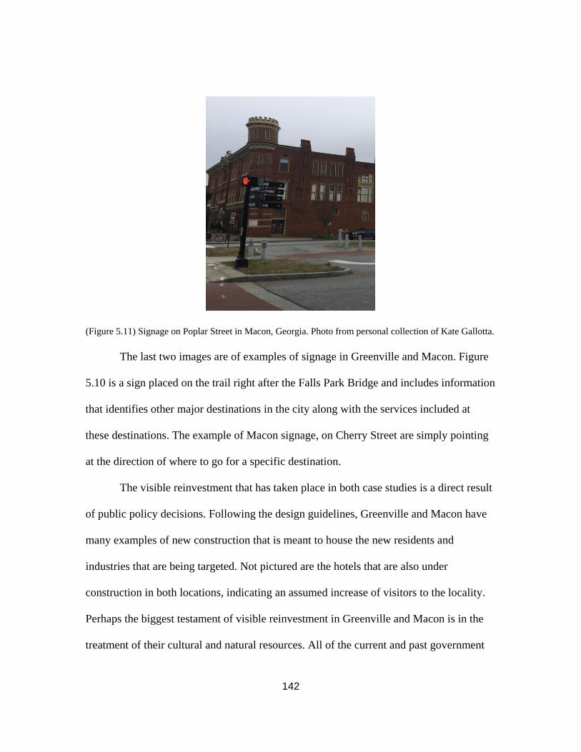
142
(Figure 5.11) Signage on Poplar Street in Macon, Georgia. Photo from personal collection of Kate Gallotta.
The last two images are of examples of signage in Greenville and Macon. Figure
5.10 is a sign placed on the trail right after the Falls Park Bridge and includes information
that identifies other major destinations in the city along with the services included at
these destinations. The example of Macon signage, on Cherry Street are simply pointing
at the direction of where to go for a specific destination.
The visible reinvestment that has taken place in both case studies is a direct result
of public policy decisions. Following the design guidelines, Greenville and Macon have
many examples of new construction that is meant to house the new residents and
industries that are being targeted. Not pictured are the hotels that are also under
construction in both locations, indicating an assumed increase of visitors to the locality.
Perhaps the biggest testament of visible reinvestment in Greenville and Macon is in the
treatment of their cultural and natural resources. All of the current and past government

143
publications have recommended the continued protections or enhancement of the
resources available. Including signage in the list of visible reinvestments is meant to
better represent the shift that Greenville’s public policy experienced. In the most current
plan, there is a specified effort in marketing the city as a tourist destination, making
signage necessary for the groups that have never been to the city before. Macon however,
the signage is a further support of identifying the destination placemaking strategy that
has been employed from beginning.
What is Missing?
The plans included in this thesis published by the cities of Greenville and Macon
cover many topics and list many initiatives over the years from 1990-2017. However,
there are a couple topics that were not discussed in the plans that could allow enhance the
resident’s quality of life. The plans summarized above did not include goals recognizing
the effect of climate change, an intention to strengthen the Historic Preservation
movement. Finally, while the plans did discuss the need for affordable housing, there was
limited guidance in how it will be approached in the future. In the next publication
(master/strategic/ comprehensive plan), it would be beneficial for the case studies to
include these topics. Macon having just updated their comprehensive plan, is not in the
position to make drastic changes until the five-year update. Greenville on the other hand,
just put out their “Request for Proposals,” looking for a planning firm to work with in

144
creating a new comprehensive plan.306 Both cities are on track to continue growing,
making new development inevitable. This new development will be affected by climate
change, it will have an effect on historic material, and will most profoundly affect the
amount of affordable housing. Often times with new development comes increased
property values, which can force residents to no longer be able to afford their home. With
residents being forced to leave, the risk of losing tangible and intangible resources
increases. These are effects that both Greenville and Macon need to address more directly
in their city plans.
First, the two case studies need to formulate an approach in response to the effects
of climate change. Both Greenville and Macon cite the value of their natural resources in
city plans and reports, but neither discuss the negative effects that could come with the
rising sea levels. With both cities putting increasing emphasis on their riverfronts, a
logical step would be conducting a study to monitor the water levels in the Reedy River
and Ocmulgee River. If the water levels are increasing, there could be negative
consequences, like flooding, in the coming years. The two cities do include elements of
sustainability with their goals to enhance walkability and increase in public
transportation. By providing the residents with alternatives to automobiles, Greenville
306 City of Greenville, “CITY OF GREENVILLE STATE OF SOUTH CAROLINA REQUEST FOR PROPOSALS,” City of Greenville: Greenville, SC, accessed April 18, 2018. http://www.greenvillesc.gov/DocumentCenter/View/10944?bidId=138 The City of Greenville put out a request for proposals in search of a firm to compile the new Comprehensive Plan, GVL 2040. This request included the required subjects to be studied as well as exploring the outcomes of the potential goals and an implementation plan. The city requires the firm to include the community opinion through forums and surveys. There is a timeline included in the request that lists the desired adoption date for the plan to be in the winter of 2019.

145
and Macon have implemented “greener” public policies. However, these policies are
included not as “green” initiatives, but as livability initiatives. Greenville and Macon
have the opportunity in the coming years to build off these transportation initiatives,
along with the greenspace development initiatives and set goals in response to climate
change.
A major consequence of new development is the loss of historic fabric in a city.
Whether it is due to demolition by neglect or no preventative zoning, there is an issue
around the country of historical structures being altered or destroyed and being replaced
with contemporary structures that seem out of place. Both Greenville and Macon lack a
government entity put in place to maintain the cultural and natural heritage in the city. It
would benefit both places to create a preservation commission with the sole purpose of
promoting the city’s history. The commission could advocate the protection of historic
buildings as well as encourage new zoning requirements to protect the context of the
whole city. Greenville has recently updated design guidelines for the commercial districts
and these guidelines include requirements of height and proportions.307 Besides massing,
however, there is little context that is maintained in the design guidelines. A preservation
commission could ensure that the design guidelines do more than prevent oversized
windows. A Preservation Commission in Greenville and Macon would better represent
the city’s stated value in its historic fabric. Currently, the burden of protecting cultural
resources falls on the backs of local nonprofits, but the efforts would be much more
307 Greenville Guidelines: City of Greenville. GREENVILLE DOWNTOWN DESIGN GUIDELINES. Greenville, SC: City of Greenville, 2017.

146
effective if made by a government entity. The commissions could also be responsible for
the updating of the two design guidelines held by the cities for their historic districts.
Greenville’s last update to the Historic District guidelines was in 2000, and Macon’s
guidelines are from 1995.308 Considering that Macon’s revitalization policies were
centered around its heritage tourism, it does not make sense that the guidelines have not
been updated more recently. There is a cited goal in the Macon Action Plan to update the
current historic district guidelines. 309 At the moment, Macon’s preservation movement is
led by local nonprofits like Newtown Macon and the Historic Macon Foundation. A
creation of a government entity could strengthen the movement and allow for increased
preservation throughout the city.
Finally, the two case studies address the issue of affordable housing in their
comprehensive plans but need to establish a better implementation plan for the goals to
be achieved. The issue is more relevant in Greenville at the current time with increasing
housing costs becoming a more publicized issue.310 A trust fund has been established by
the city specifically to invest in the improvement of current housing options as well as
new housing options. The projects that the city will be focusing on with this fund is for
308 Macon Guidelines: Macon-Bibb County Planning and Zoning Commission, Design Guidelines for Macon's Historic Zoning Districts and Downtown. Macon-Bibb County, GA: Macon-Bibb County, 1995. Greenville Guidelines: City of Greenville, Design Guidelines Design Guidelines Design Guidelines for Preservation Overlay Districts (Greenville, SC: City of Greenville, 2000), Page1-3. 309 Macon- Bibb County Urban Development Authority, Macon Action Plan, 98-99. 310 Deb Long, "Affordable housing: The ultimate stabilizer for families," Greenville News (Greenville, SC), October 6, 2017, accessed April 19, 2018, https://www.greenvilleonline.com/story/opinion/2017/10/06/affordable-housing-ultimate-stabilizer-families/730714001/.

147
families that fall within the income range of $15,000-$55,000. The vote to create the
fund was unanimous, but now the question to answer is what is next for the money in the
fund. However, there has not been any major change to the housing situation. Back in
2016, the Greenville Housing Authority set the initiative of investing over $80 million
into affordable housing, but this has not come to fruition. While the planning process
with all this funding continues, the city needs to finalize this process and make moves
towards accomplishing the housing initiatives set. In the short term, steps that could be
taken to remediate the situation is establishing zoning laws that require fixed rates of the
rental properties. These zones should be mixed throughout the commercial district and
areas where rents are typically higher in order to create a diverse housing population.
There are examples of projects like the Dorchester Art + Housing Collaborative, that
successfully weave the solution of preserving historic fabric and promoting affordable
housing together.311 Both Greenville and Macon have opportunities to create similar
housing projects, it will just take immense communication between the public and private
sector.
311 Rebuild Foundation, "Dorchester Art + Housing Collaborative," Rebuild Foundation, accessed April 26, 2018, https://rebuild-foundation.org/site/dorchester-art-housing-collaborative/.
148
CHAPTER SIX:
LESSONS LEARNED AND CONCLUSIONS
This thesis compares the revitalization of Greenville, South Carolina and
Macon, Georgia through a study of their public policies. Greenville and Macon are
similar in many ways. Both cities prospered after the Civil War with a booming textile
industry. They both are conveniently located on rivers. And both are now near major
cities. When the textile industry collapsed, both cities experienced an industrial void,
forcing their residents to leave and find new jobs. The suburban sprawl shook their
downtowns again, resulting in a fall of property values and tax collection rates. With their
economies at low points, Greenville and Macon commenced planning and
implementation efforts to revitalize their once booming cities. Macon chose to adopt a
revitalization strategy which focused on the heritage tourism potential of the town.
Greenville adopted a strategy which was emphasized an increase the level of livability for
the residents. The two cities began working towards revitalization at the same time, and
yet, the cities are in two different phases of the revitalization process. Since 1990,
Greenville has prospered and has been consistently recognized for its success in
revitalization. Macon, on the other hand, is still working towards finding success. This
final chapter will explain lessons that can be taken from the comparative study then
discuss recommendations for the next steps in Greenville and Macon.

149
LESSONS LEARNED
There are three lessons to be taken from the successes achieved by Macon and
Greenville. The first is a very common recommendation in revitalization today.
Enhancing walkability and connectivity is a goal included in Greenville’s original plans
and Macon’s most recent plans. With walkability comes connectivity, which promotes
business and community involvement throughout the city. Macon has most recently been
adopting public policies that promote the walkability of the downtown, as well as better
connecting the large county to the urban core. The second lesson is another common
recommendation in revitalization today, but for good reason. Greenville experienced a lot
of success after enhancing the Fall’s Park area, and now Macon is working towards
enhancing the green/ community gathering space within its boundaries as well. The
removal of the bridge and cleaning of the river waterfront provided Greenville with an
invaluable resource. Used as a gathering place but also tourist destination, the value of
creating a greenspace within an urban environment is very important. Macon has
identified interest in the promotion of its natural resources but is still working towards
better connectivity to make the greenspaces accessible. The third lesson is a more unique
element that Greenville and Macon have taken advantage of- the positive relationship
between a city and higher education. In both cases, the schools gave back to the city in
some form- Mercer is very involved in historic preservation within Macon and Clemson
University and University of South Carolina both have locations in Greenville. These
three lessons are initiatives that Greenville began its revitalization journey with and

150
experienced marked success with. Macon has since followed suit and is working towards
accomplishing the same initiatives.
Lesson One
In a modern US city, the movement of automobiles played a huge role in the
planning and layout of the downtown. This is more obvious in the suburbs where the only
way to get somewhere is by driving. To improve connectivity, a city government needs to
identify where people are going the most and how they get there. This lesson becomes
more important when a city experiences population growth and economic growth. With
an increased number of people, there will be an increased amount of movement around
the city. For Greenville and Macon, both of the current plans include transportation as an
element that needs improvement. Greenville is working towards improving the public
transit and furthering the connectivity to the outer neighborhoods. Like Greenville,
Macon has stated the intention to improve public transit and connectivity, but there is an
added goal of lessening car traffic in Macon altogether.312 The Macon Action plan lists
the goal to have less cars on the road by improving the bike and walking trails are a
viable alternative to driving.
Greenville’s Main Street is the city’s claim to fame. One of the major components
that makes Main Street so successful is the walkability element. With the wide sidewalks
and safe crossing spots, Main Street encourages people to walk around the city instead of
driving. The increased walkability also creates an increased connectivity. Activities that
occur around Greenville are accessible by Main Street, making it the “spine” of the city-
312 Macon-Bibb County. Forward Together: Strategic Plan, 10.

151
which was the goal in LDR’s 1989 development report.313 Greenville is not the only city
that has embraced the benefits of increasing walkability. Today, there are more and more
midsized cities adopting policies with a larger emphasis on increasing walkability-
Knoxville, TN; Salisbury, MD, Las Cruces, NM, and Rochester, NY are all the most
recent examples of Smart Growth America highlights in walkability.314 There have also
been studies to support the walkability movement. In 2012, The Washington Post
published an article that explained how increased walkability has a positive correlation to
property values: The more walkable a location, the higher the property value.315
With the consolidation, Macon was given an opportunity to evaluate what was
working in their policies and make appropriate changes to what was not. The Strategic,
Comprehensive, Urban Redevelopment plans have all been updated since 2014. All of
these plans have decided to invest effort into making a place that is walkable, but also
bike friendly. With the Ocmulgee Trail and Riverfront trails, enhancing the biking
connectivity between these two trails and to the downtown is supposed to encourage
people to visit all the destinations along the trail. In the Comprehensive Annual Financial
Reports for many of the most recent years, there is a growing amount of funding being
put towards trail enhancement and also pedestrian safety. Macon has been working
towards improving the connectivity of downtown by adding safety for pedestrians and
313 Land Design/Research, Inc., Downtown Development Strategy, 11. 314 Smart Growth America, "Complete Street Archives," Smart Growth America, accessed March 22, 2018, https://smartgrowthamerica.org/tag/complete-streets/. 315Laura Barnhardt Cech, "Walkability increasingly drives developers and real estate market," The Washington Post (Washington, DC), November 16, 2012, accessed April 19, 2018, https://www.washingtonpost.com/realestate/walkability-increasingly-drives-developers-and-real-estate-market/2012/11/15/cfafb342-286a-11e2-b4e0-346287b7e56c_story.html?utm_term=.c7334e15b6c9.

152
improving Second Street and Cherry Street. In the Macon Action Plan, one of the goals
for transportation is to “prioritize pedestrian safety and connectivity at signalized
intersections”316 The 2040 Comprehensive Plan also listed goals to be met that are
concerned with connectivity to outer neighborhoods, encouraging accessibility for all
residents.317
Lesson Two
Another major recommendation for community-based planning is the
implementation of a planned greenspace that is accessible to the entire community. A
greenspace creates a gathering point while embracing the natural resources of a place
which strengthens the connectivity. Whether it is a dog park, riverwalk, trail, playground,
etc., there are health benefits that come with the integration of a greenspace in an urban
environment. There is also a positive correlation between greenspace proximity and
property value.318 There are examples of successful greenspaces in all large cities-
Central Park in New York City; Millennium Park in Chicago; Atlanta Beltline in Atlanta.
In addition to creating park settings, the greenspace can also include an increased
number of tree and shrub plantings, which adds to the aesthetic appeal of the city. From
this case study, the importance of a greenspace is clear through the continued
prioritization of the Falls Park in Greenville. This park has received national attention and
is now a major destination in the South because of its beautiful bridge and grounds.
316 Macon- Bibb County Urban Development Authority, Macon Action Plan, 123. 317 Macon-Bibb County Planning and Zoning Commission, Big Picture Comprehensive, 40. 318 Justin Feldman, "Health benefits of urban vegetation and green space: Research roundup," Journalist Resource, accessed March 22, 2018, https://journalistsresource.org/studies/environment/cities/health-benefits-urban-green-space-research-roundup.

153
Besides this park, the downtown of Greenville has a lot of greenery in the form of plants
and trees, making it an appealing streetscape. In its 2008 Master plan, Greenville
recognized that not only to parks provide a unique identity, they also enhance the quality
of life.319 Macon has also decided in its recent plans to upgrade its natural resources with
what it terms “green infrastructure”320 and to also “improve and expand open spaces.”321
Lesson Three
The unique lesson to take away from this comparative study is the benefit of a
relationship between a city government and an institute of higher learning. Both
Greenville and Macon have fostered and continue today to work with college and
universities nearby. While Greenville does not have a higher institution downtown, there
are many in close proximity as well as satellite campuses being downtown.322 In Plan-It
Greenville, one of the objectives was to continue the partnership between Greenville and
the higher education representatives.323 Mercer University is located in downtown
Macon. The relationship between Macon and Mercer has had a large positive effect on
the economy of Macon. Education in Macon was consistently listed as a community
concern. In general, the citizens are asking for an improved education system, making a
strong relationship with Mercer of the utmost importance. The 2040 Comprehensive Plan
319 Sasaki Associates Inc., Downtown Greenville Master Plan, 283. 320Macon-Bibb County Planning and Zoning Commission, Big Picture Comprehensive, 109. 321 Macon- Bibb County Urban Development Authority, Macon Action Plan, 86. 322 Clemson University, University of South Carolina, Furman University, Bob Jones University, and Greenville Technical College 323 City of Greenville Planning and Zoning. Plan-It Greenville: 63.

154
stated that a goal to accomplish would be to form partnerships between high schools and
local universities to establish a dual credit system.324
A benefit of having access to higher education in close proximity to a city is the
general public is more educated. With more opportunities for schools, there are more job
opportunities. In addition to job opportunities, the general population will increase with
more students and faculty moving to the area. An increase in population boosts the
economy and lowers vacancy rates amongst properties.
CONCLUSION AND RECOMMENDATIONS
This thesis began with a simple question: Should a city government put residents
or visitors first when creating policies for revitalization? The decision to compare
Greenville and Macon was based on the shared characteristics of their history, but their
adoption of different policies addressing their future. By identifying the trends and
outcomes of these policies, it is clear that Greenville’s strategy has experienced the most
positive effects. In support of this assertion, Macon has noticed the positive effects and
updated their policies to be more closely aligned with Greenville’s.
In conclusion, Macon’s strategy of prioritizing the tourist population resulted in a
lack of increase of the general property values and tax collections over the years.
Through the comparison of public policies, it is evident that the more effective strategy
was employed by Greenville, which created policies that put an emphasis on enhancing
quality of life and putting less emphasis on tourism initiatives. This strategy resulted in
324 Macon-Bibb County Planning and Zoning Commission, Big Picture Comprehensive, 24.

155
an increase in revenue from tax collections and business permits as well as higher
property values. Livability is defined by the Partners of Livable Communities as “the sum
of factors that add up to a community’s quality of life- including the built and natural
environment, economic prosperity, social stability and equity, educational opportunities,
and cultural, entertainment and recreation possibilities.”325 Greenville’s dedication to
improving livability is visible in the policies adopted over the years. Whether it is
improving the walkability through “pedestrian connections and linkages”326 or “maintain
diversity and affordability”327 in its housing availability, Greenville has continued to
promote and enhanced quality of life. Macon, on the other hand, prioritized the potential
tourist population first and the permanent residents second in its original policies. The
promotion of local heritage in the museums, Cherry Blossom Festival, or Ocmulgee
Monument, did not result in the profound success that was hoped for, causing a shift in
priorities for Macon.
Today, Macon is still working towards revitalization. The policies that were put in
place for the first 20 years targeted the tourist population, and overall, brought little
success to the town. Macon decided to move away from its long running theme of
attracting visitors, and with evidence seen in its strategic plan, puts more emphasis on the
level of livability in its boundaries. There is an interest in fostering community and
creating greenspaces for residents to use. The consolidated government has also put an
325 Partners for Livable Communities, "What is Livability?," Partners for Livable Communities, accessed April 19, 2018, http://livable.org/about-us/what-is-livability. 326 Land Design/Research, Inc., Downtown Development Strategy, 16. 327 Sasaki Associates Inc., Downtown Greenville Master Plan, 7.
156
emphasis on communication between it and the outer agencies that directly affect the
lives of the citizens, like the Education Board. There is a new interest in creating
walkable connections around the city as well as enhancing its bike paths, with the desire
to make cars less prevalent downtown. In an article by Smart Growth, this change is put
into words- “In Macon, this old approach focused on bringing something (companies,
etc.) from outside instead of focusing on building up the community from within. Macon
leaders want to change that.”328 However, the shift made by Macon is not completely
forgetting its old strategy. There is still an interest in the promotion of Macon and its
resources, specifically the utilization of the Ocmulgee Heritage Trail as a destination in
both the 2040 Comprehensive Plan and the Macon Action Plan. Many goals are designed
around the assumption that the Ocmulgee Monument will receive Landmark and Preserve
designation, making it an even bigger destination. Playing off of this assumed outcome,
Macon is focused on improving its current biking infrastructure, recognizing that the
newly designated trail will want more people to come to visit Macon.
Greenville is in a different situation. The city, with the policies applied from the
beginning, has experienced consistent growth which has been recognized at an
international level. Again, and again, Greenville has been presented with accolades that
spotlight its original purpose: creating a livable city. Today, Greenville has shifted its
focus to improving the tourist population’s experience. Essentially, the city realized that
their basis of livability was high enough that it could put more focus in attracting visitors,
328 "“A CHANGE IS GONNA COME” IN MACON, GEORGIA," Smart Growth America (blog), entry posted August 24, 2017, accessed March 1, 2018, https://smartgrowthamerica.org/amazing-place-series-change-gonna-come-macon-georgia/.

157
and now Greenville has made many lists of places to visit in the country. The “Yeah,
That Greenville” campaign is that department responsible for marketing Greenville. First
formed in 2012, the city has completely boomed in the time since, with constantly
growing numbers of hotel rooms, and online searches.329 Its recognition has earned the
city a place on many “Top” list like Travel + Leisure’s “50 Top Places (in the world) to
Travel in 2018”, or the US News & World Report List for “Top 10 Underrated Cities for
Art Lovers 2018.”330
Overall, it appears that two cities did a swap in their revitalization priorities.
Starting in the 1970s, the cities prioritized two different target audiences. Greenville
made the decision of creating a great place for its residents to live. Through its emphasis
on connectivity, creation of job opportunities, and attractive streetscapes, Greenville
achieved a high level of livability. Macon originally made the decision to use its
resources like the its heritage or convenient transportation opportunities as a way to
attract people who didn’t live in Macon to visit. While there is visible growth in both
cities, Greenville’s growth is more profound. There is a large jump in the statistics of
Macon in terms of property tax revenue, median income, and population but this mostly
due to the consolidation. Before the consolidation, there was little growth shown in
Macon. Now, realizing that the original strategy of attracting visitors has not had a
dramatic effect, the city is changing towards building a community-based place.
329 Cindy Landrum, "Yeah, This Is an Article about Yeah, That Greenville," The Greenville Journal (Greenville, SC), March 3, 2017, accessed March 19, 2018, https://greenvillejournal.com/2017/03/03/yeah-article-yeah-greenville/. 330 City of Greenville, "Greenville, SC: The Greenville Everyone's Been Talking About," Yeah, That Greenville, accessed March 19, 2018, https://www.visitgreenvillesc.com/.
158
Greenville, having started with community-based building, has experienced success and
growth. Now, the city is growing and changing towards marketing itself to visitors. This
shift is supported in the Comprehensive Annual Financial Reports for the last 7 years,
where there is a growing amount of the general fund designated for “tourism
expenditures.” Today, the City of Greenville is used as an example for “community
place-based growth” and has held conventions to speak to representatives about the
decisions made over the years in their public policies.
Moving forward, the two cities still have issues to be addressed as they continue
to grow. Most pressing is the issue of affordable housing, especially in Greenville. With
all the economic growth Greenville has experienced, the city is being developed more
rapidly, resulting in a loss of housing that is affordable to a large portion of the current
population. In their new comprehensive plan, Greenville needs to address this issue and
create an implementation plan to see results. Macon is on track to experience the same
lack of affordable housing as Greenville if the city continues to develop. Another key
element that is not present in the current city government is the protection of historic
resources. While there are goals in the city plans to encourage preservation, the city
governments of both cities do not have any entity in place to ensure these resources
remain unthreatened. It should be a priority for Greenville and Macon to establish an
official mechanism to protect historic buildings and sites in the midst of new
development. Finally, the cities need to dictate a plan to prepare for the effects of climate
change in the next five years, especially since Greenville and Macon place so much value
on their natural resources.

159
The comparison of revitalization strategies is important, and Macon and
Greenville are good examples to use. It is important because of the relatability of the two
cities. Both have struggled with increasing economic activity and housing affordability,
and both have experienced positive effects from the enhancement of their resources.
Many cities all over the country share these experiences and are in the process of
updating the current strategic or master plan for the city government. This thesis can
serve as a reference to identify what policies Greenville and Macon chose, and what the
outcomes of those policies were.

160
CHAPTER SEVEN:
BIBLIOGRAPHY
"“A CHANGE IS GONNA COME” IN MACON, GEORGIA." Smart Growth America
(blog). Entry posted August 24, 2017. Accessed March 1, 2018.
https://smartgrowthamerica.org/amazing-place-series-change-gonna-come-macon-
georgia/.
Affordable Housing Steering Committee, comp. Balancing Prosperity and Housing
Affordability in Greenville. Greenville, SC: City of Greenville, 2016. Accessed March 1,
2018. http://www.greenvillesc.gov/DocumentCenter/View/9304.
Anderson, Nancy B. "Macon." New Georgia Encyclopedia. 30 August 2017. Web. 18
December 2017. http://www.georgiaencyclopedia.org/articles/counties-cities-
neighborhoods/macon.
Bainbridge, Judith. "Chicora College Leaves Greenville." Greenville News (Greenville,
SC), November 18, 2017. Accessed January 26, 2018.
http://www.greenvilleonline.com/story/news/local/greenville-roots/2017/11/18/chicora-
college-greenville-sc/875960001/.
Bell, Rudolph. "Upstate Michelin Turns 40." Greenville News (Greenville, SC), June 25,
2015.Accessed January 26, 2018.
https://www.greenvilleonline.com/story/money/business/2015/06/25/michelin-greenville-
plant-anniversary/29296583/.
Bloomberg LP. "Company Overview of LDR International Inc." Bloomberg. Accessed
March 19, 2018.
https://www.bloomberg.com/research/stocks/private/snapshot.asp?privcapId=667371.
BMW Manufacturing CO., LLC, "Production Overview," BMW Group Plant
Spartanburg, accessed September 19, 2017,
https://www.bmwusfactory.com/manufacturing/production-overview/.
"Boll Weevil." In Encyclopædia Britannica. Encyclopædia Britannica, Inc, 2017.
Accessed September 17, 2017. https://www.britannica.com/animal/boll-weevil.
Boyanski, John. Reimagining Greenville: Building the Best Downtown in America.
Charleston, SC: The History Press, 2013.
Bozeman, Glenda Barnes. Macon: Then & Now (Chicago, IL: Arcadia Publishing, 2001).

161
Cech, Laura Barnhardt. "Walkability increasingly drives developers and real estate
market." The Washington Post (Washington, DC), November 16, 2012. Accessed April
19, 2018.https://www.washingtonpost.com/realestate/walkability-increasingly-drives-
developers-and-real-estate-market/2012/11/15/
cfafb342-286a-11e2-b4e0-346287b7e56c_story.html?utm_term=.c7334e15b6c9.
Cherry, Bekaerts & Holland. (2001-2005). Comprehensive Annual Financial Reports for
the City of Greenville (2000-2004). Greenville, SC: City of Greenville.
The Chattanooga news. (Chattanooga, Tenn.), 18 April 1919. Chronicling America:
Historic American Newspapers. Lib. of Congress.
<http://chroniclingamerica.loc.gov/lccn/sn85038531/1919-04-18/ed-1/seq-2/>
City of Greenville. "Affordable Housing." City of Greenville South Carolina. Accessed
March 1, 2018. http://www.greenvillesc.gov/1275/Affordable-Housing.
City of Greenville. "Awards & Recognition." City of Greenville South Carolina.
Accessed March 1, 2018. http://www.greenvillesc.gov/documentcenter/view/691.
City of Greenville. "City Park and Reedy River Development." City of Greenville South
Carolina. Accessed March 22, 2018. https://www.greenvillesc.gov/1219/City-Park-and-
Reedy-River-Redevelopment
City of Greenville, Design Guidelines Design Guidelines Design Guidelines for
Preservation Overlay Districts (Greenville, SC: City of Greenville, 2000), [Page1-3],
accessed March 1, 2018, https://www.greenvillesc.gov/DocumentCenter/View/176.s.
City of Greenville, "Downtown Reborn," The City of Greenville, South Carolina, last
modified March 31, 2017, accessed September 19, 2017,
https://gis.greenvillesc.gov/downtownreborn/index.html.
City of Greenville, Downtown Development Strategy: Greenville, South Carolina,
accessed September 17, 2017, http://www.greenvillesc.gov/DocumentCenter/View/6511.
City of Greenville. "Education." City of Greenville South Carolina. Accessed March 22,
2018. https://www.greenvillesc.gov/751/Education.
City of Greenville. "Financial Publications." City of Greenville, South Carolina.
Accessed March 22,2018. https://www.greenvillesc.gov/401/Financial-Publications.
City of Greenville. "Greenville, SC: The Greenville Everyone's Been Talking About."
Yeah, That Greenville. Accessed March 19, 2018. https://www.visitgreenvillesc.com/.

162
City of Greenville. GREENVILLE DOWNTOWN DESIGN GUIDELINES. Greenville,
SC: City of Greenville, 2017. Accessed March 1, 2018.
http://www.greenvillesc.gov/DocumentCenter/View/7912.
City of Greenville. Greenville West Side Comprehensive Plan. Greenville, SC: City of
Greenville. 2014. Accessed March 1, 2018.
http://www.greenvillesc.gov/DocumentCenter/View/289.
City of Greenville, SC. "The History of Greenville." City of Greenville, South Carolina.
Accessed September 19, 2019.
http://www.greenvillesc.gov/DocumentCenter/View/1317.
City of Greenville Planning and Zoning. Plan-It Greenville: The City of Greenville’s
Comprehensive Plan 2009. Greenville, SC: City of Greenville, 2017. Accessed March 1,
2018. http://www.greenvillesc.gov/DocumentCenter/View/289
Chicago Metropolitan Agency for Planning. "Historic Preservation Strategies." CMAP.
Last modified September 13, 2011. Accessed January 26, 2018.
http://www.cmap.illinois.gov/about/2040/
supporting-materials/process-archive/strategy-papers/historic-preservation/strategies.
Clifton, Lipford & Taylor. (1992-2006). Comprehensive Annual Financial Reports for
the City of Macon (1991-2005). Macon, GA: City of Macon.
Curtis, Debbie. National Register of Historic Places Nomination: Macon Historic
District, Bibb County, GA. Macon, GA: Historic Preservation Division, Georgia
Department of Natural Resources, 1995.
Department of Housing and Urban Development. "HUD AWARDS $19 MILLION
GRANT TO MACON, GA TO TRANSFORM PUBLIC HOUSING, HELP
RESIDENTS." News release. October 5, 2001. Accessed March 1, 2018.
https://archives.hud.gov/news/2001/pr01-098.cfm.
Economic and Community Development Department. Macon-Bibb Urban
Redevelopment Plan. Macon-Bibb County, GA: Macon-Bibb County, 2016. Accessed
February 2, 2018. http://www.maconbibb.us/wp-content/uploads/2016/04/Macon-Bibb-
County-2016-URP-Draft.pdf.
Feldman, Justin. "Health benefits of urban vegetation and green space: Research
roundup.” Journalist Resource. Accessed March 22, 2018.
https://journalistsresource.org/studies/environment/cities/health-benefits-urban-green-
space-research-roundup.

163
The Fiscal Implications of Development Patterns: Macon, GA.: Smart Growth America,
2015.
Floore, Chris. "Macon-Bibb County earns national communication awards." News
release. September 22, 2015. Accessed March 1, 2018.
http://www.maconbibb.us/nationalcommunicationawards/.
Fort Hawkins. Photograph. Gateway Macon. Accessed April 23, 2018.
https://www.gatewaymacon.org/ arts-and-culture-macon-ga/fort-hawkins.cms
GABBA. "About GABBA." GABBA: Georgia Allman Brothers Band Association.
Accessed January 26, 2018. http://www.gabbafest.org/mission/.
Gaines, Jim. "Reichert wins Macon-Bibb mayor’s office by wide margin over Ellis." The
Telegraph: Macon, GA. October 15, 2013. accessed December 28, 2017.
http://www.macon.com/news/politics-government/election/article30124359.html.
Gateway Macon. "Summer Festivals Overview." Gateway Macon. Last modified 2018.
Accessed January 26, 2018. https://www.gatewaymacon.org/festivals-macon-ga/bragg-
jam.cms.
"Georgia road map with cities and towns ?." Map. OntheWorldMap. Accessed April 23,
2018. http://ontheworldmap.com/usa/state/georgia/georgia-road-map-with-cities-and-
towns.html.
Greene, Finney & Horton. (2006-2017). Comprehensive Annual Financial Reports for
the City of Greenville (2005-2017). Greenville, SC: City of Greenville.
Hillyer, Reiko. Designing Dixie: Tourism, Memory, and Urban Space in the New South.
Charlottesville, VA: University of Virginia Press, 2014.
H.R. 1171, 2014 Gen. Assem. (Ga.). Accessed March 22, 2018.
http://www.legis.ga.gov/Legislation/20112012/126041.pdf.
Hudnut, William H., III. Cities on the Rebound: A Vision for Urban America.
Washington, DC: Urban Land Institute, 1998
Hyer, Virginia. "The South Is Home to 10 of the 15 Fastest-Growing Large Cities." News
release. May 25, 2017. Accessed March 1, 2018.
https://www.census.gov/newsroom/press-releases/2017/cb17-81-population-estimates-
subcounty.html.

164
IFEA. "Pinnacle Awards: IFEA/Haas & Wilkerson Pinnacle Awards Competition."
IFEA. Accessed March 1, 2018. http://www.ifea.com/p/industryawards/pinnacleawards.
International Cherry Blossom Festival. "Awards." Macon, Georgia's International Cherry
Blossom Festival. Accessed March 1, 2018. https://cherryblossom.com/about-the-
festival/awards/.
Jacobs, Jane. The Death and Life of Great American Cities. New York, NY: Vintage
Books, 1992.
KPMG. (1991-2001). Comprehensive Annual Financial Reports for the City of
Greenville (1990-2000). Greenville, SC: City of Greenville.
Land Design Research, Inc.. Downtown Development Strategy. Greenville, SC: City of
Greenville, April 1989. Accessed March 19th, 2018.
https://www.greenvillesc.gov/DocumentCenter/View/6511
Land Design/Research, Inc., Report Card and Strategic Assessment, Greenville, SC: City
of Greenville, February 1997, Accessed March 19th, 2018,
https://www.greenvillesc.gov/DocumentCenter/View/6512
Landrum, Cindy. "Yeah, This Is an Article about Yeah, That Greenville." The Greenville
Journal (Greenville, SC), March 3, 2017. Accessed March 19, 2018.
https://greenvillejournal.com/2017/03/03/yeah-article-yeah-greenville/.
Larry Hanson, ed., Handbook for Georgia Mayors and Councilmembers, fifth ed.
(Atlanta, GA: Georgia Municipal Association, 2018), 1, accessed April 26, 2018,
https://www.gmanet.com/GMASite/media/PDF/handbook/planning.pdf.
Lee, Maggie. "Mercer planning medical school expansion in former Music Hall of Fame
building." The Telegraph (Atlanta, GA), March 13, 2012. Accessed January 26, 2018.
http://www.macon.com/latest-news/article28645864.html.
Leah Fleming, "Macon Loses Historic Georgia State Fair to New City," Georgia Public
Broadcasting (Atlanta, GA), October 23, 2013, [Page #], accessed December 28, 2017,
http://www.gpb.org/news/2013/10/23/macon-loses-historic-georgia-state-fair-to-new-
city.
Local Government - Provisions Applicable to Special Purpose Districts and Other
Political Subdivisions, S.C. Code Ann. §§ 6-29-510 (1976 & Supp. 2017).
Long, Deb. "Affordable housing: The ultimate stabilizer for families." Greenville News
(Greenville, SC), October 6, 2017. Accessed April 19, 2018.

165
https://www.greenvilleonline.com/story/opinion/2017/10/06/affordable-housing-ultimate-
stabilizer-families/730714001/.
Macon Area Transportation Study. Transportation Improvement Plan. Macon, GA:
Macon-Bibb County. November 9, 2016. Accessed March 20, 2018.
https://drive.google.com/file/d/0B8lE7tc0Z-SpVnBCWC1xRUNTQnc/view
Macon-Bibb County Convention & Visitors Bureau, "Facts About Macon, GA," Macon:
Where Soul Lives, last modified 2015, accessed December 28, 2017,
https://www.maconga.org/media/fact-sheet/.
"Macon-Bibb County, GA." DATA USA. Accessed March 1, 2018.
https://datausa.io/profile/geo/macon-bibb-county-ga/
Macon Bibb County. Forward Together: Strategic Plan. Macon, GA: Macon- Bibb
County. 2014. Accessed March 22, 2018. http://www.maconbibb.us/wp-
content/uploads/2015/05/Macon-Bibb-County-Strategic-Plan.pdf
Macon-Bibb County: Land Bank Authority. "About Us." Macon-Bibb County: Land
Bank Authority. Last modified 2018. Accessed February 2, 2018.
http://maconlandbank.org/about-us/.
Macon- Bibb County Planning and Zoning Commission. Big Picture Comprehensive
Plan 2030. Macon, GA: City of Macon, 2006.
Macon-Bibb County Planning and Zoning Commission. Design Guidelines for Macon's
Historic Zoning Districts and Downtown. Macon-Bibb County, GA: Macon-Bibb
County, 1995. Accessed March 1, 2018.
http://www.ced.uga.edu/pdfs/designguidelines/macon_downtown_1995.pdf.
Macon- Bibb County Urban Development Authority. Macon Action Plan. Macon-Bibb
County, GA: Macon-Bibb County, 2015. Accessed March 1, 2018.
http://www.maconactionplan.com/.
Macon Economic Development Commission. "Overview." MACON. Accessed March
22, 2018. http://www.maconworks.com/overview-industry-review.cms.
Maggie Lee, "Macon-Bibb merger proposes smaller, redesigned local government," The
Telegraph (Macon, GA), February 28, 2012, accessed December 28, 2017,
http://www.macon.com/news/article28642771.html.
"Map of Alabama, Georgia and Florida." Map. OntheWorldMap. Accessed April 23,
2018. http://ontheworldmap.com/usa/state/alabama/map-of-alabama-georgia-florida.html.

166
Market Profile. Chart. Esri, 2016. Accessed March 1, 2018. http://www.greenvillesc.gov/
DocumentCenter/View/606.
Mauldin Jenkins. (2007-2014). Comprehensive Annual Financial Reports for the City of
Macon (2006-2014). Macon, GA: City of Macon.
Mauldin Jenkins. (2014-2017). Comprehensive Annual Financial Reports for Macon-
Bibb County (2014-2017). Macon-Bibb County, GA: Macon-Bibb County.
Maurer, Tracy. Macon Celebrates the Millennium. (Montgomery, AL. Community
Communications, Inc. 2001).
McLarty, Susan. "Speak up about the need for affordable housing." The Greenville
Journal
(Greenville, SC), October 5, 2017. Accessed March 19, 2018.
https://greenvillejournal.com/2017/10/05/mclarty-speak-need-affordable-housing/.
Meeks, Stephanie and Kevin C. Murphy, The Past and Future City (Washington, DC:
Island Press, 2017)
Middle Georgia Regional Airport. "Information." Middle Georgia Regional Airport.
Accessed March 22, 2018. https://iflymacon.com/information.cms.
Mitchell, Anna B. "Greenville's tourism efforts yield big payoff." The Post and Courier
(Charleston, SC), January 28, 2018, Business&Tech, E1-E2.
National Conference of State Historic Preservation Officers. "Federal Rehabilitation Tax
Credit (Historic Tax Credit)." NCSHPO. Accessed March 22, 2018.
http://ncshpo.org/issues/historic-tax-credit/.
National Park Service, "Stories," Ocmulgee: National Monument Georgia, last modified
July 7, 2016, accessed December 28, 2017,
https://www.nps.gov/ocmu/learn/historyculture/stories.htm.
National Trust for Historic Preservation. "National Treasures: Charleston." Saving
Places. Accessed January 26, 2018.
https://savingplaces.org/places/charleston#.WmqDr6inFPY.
Ocmulgee National Park & Preserve Initiative, "Welcome," Ocmulgee National Park and
Preserve Initiative, last modified 2017, accessed December 28, 2017,
http://www.ocmulgeepark.org/.
Ortiz, Kasandra. "Store closures continue at Macon Mall." 13WMAZ (Macon, GA),
March 20, 2017. Accessed March 22, 2018. http://www.13wmaz.com/article/news/local/

167
store-closures-continue-at-macon-mall/424134656.
Palma, Dolores P. "Downtown Revitalization Myths." Illinois Principal Review, July
1995, 22. Accessed March 22, 2018. http://www.lib.niu.edu/1995/im950719.html.
Partners for Livable Communities. "What is Livability?" Partners for Livable
Communities. Accessed April 19, 2018. http://livable.org/about-us/what-is-livability.
Project for Public Spaces. "What is Placemaking?" Project for Public Spaces. Accessed
January 26, 2018. https://www.pps.org/article/what-is-placemaking.
Ramati, Phillip. "Now that Georgia Music Hall of Fame is closing, officials wonder ‘now
what?’." The Telegraph (Macon, GA), May 26, 2011. Accessed January 26, 2018.
http://www.macon.com/news/article28610632.html.
Rebuild Foundation. "Dorchester Art + Housing Collaborative." Rebuild Foundation.
Accessed April 26, 2018. https://rebuild-foundation.org/site/dorchester-art-housing-
collaborative/.
Rosenberg, Geri. "Amazing Place Cities Explore Greenville, SC, The South's Best Kept
Secret." Smart Growth America (blog). Entry posted December 4, 207. Accessed March
1, 2018. https://smartgrowthamerica.org/amazing-place-greenville/.
"Rules for river corridor protection –GA EPD." WWALS Watershed Coalition
(Suwannee RIVERKEEPER®). Accessed April 23, 2018.
http://wwals.net/2013/02/10/rules-for-river-corridor-protection-ga-epd/.
Sasaki Associates, Inc. "About Us." Sasaki. Accessed March 19, 2018.
http://www.sasaki.com/about-us/.
Sasaki Associates Inc., Downtown Greenville Master Plan, Greenville, SC: City of
Greenville, June 2008. Accessed March 19th,
2018.https://www.greenvillesc.gov/DocumentCenter/View/283
Smart Growth America. "Amazing Place: Six Cities Using the New Recipe for Economic
Development."Smart Growth America: Making Neighborhoods Great Together, June
2016. Accessed January 26, 2018. https://smartgrowthamerica.org/resources/amazing-
place/.
Smart Growth America. "Complete Street Archives." Smart Growth America. Accessed
March 22, 2018. https://smartgrowthamerica.org/tag/complete-streets/.
The Guardian (New York, NY). "The Bilbao Effect: is 'starchitecture' all it’s cracked up
to be? A history of cities in 50 buildings, day 27." April 30, 2015. Accessed January 26,

168
2018. https://www.theguardian.com/cities/2015/apr/30/Bilbao-effect-gehry-guggenheim-
history-cities-50-buildings.
The State Museum of Pennsylvania. "Building the Suburban Dream." Levittown PA.
Accessed March 22, 2018. http://statemuseumpa.org/levittown/one/b.html.
The Union times. (Union, S.C.), 17 Sept. 1915. Chronicling America: Historic American
Newspapers. Lib. of Congress.
<http://chroniclingamerica.loc.gov/lccn/sn93067853/1915-09-17/ed-1/seq-3/>
United States Environmental Protection Agency. "Federal Safe Drinking Water Act."
EPA. Accessed March 22, 2018. https://www.epa.gov/sdwa
1990 Census of Population General Population Characteristics South Carolina.
Washington, DC: US Department of Commerce, 1990.