Embed Size (px)
Citation preview
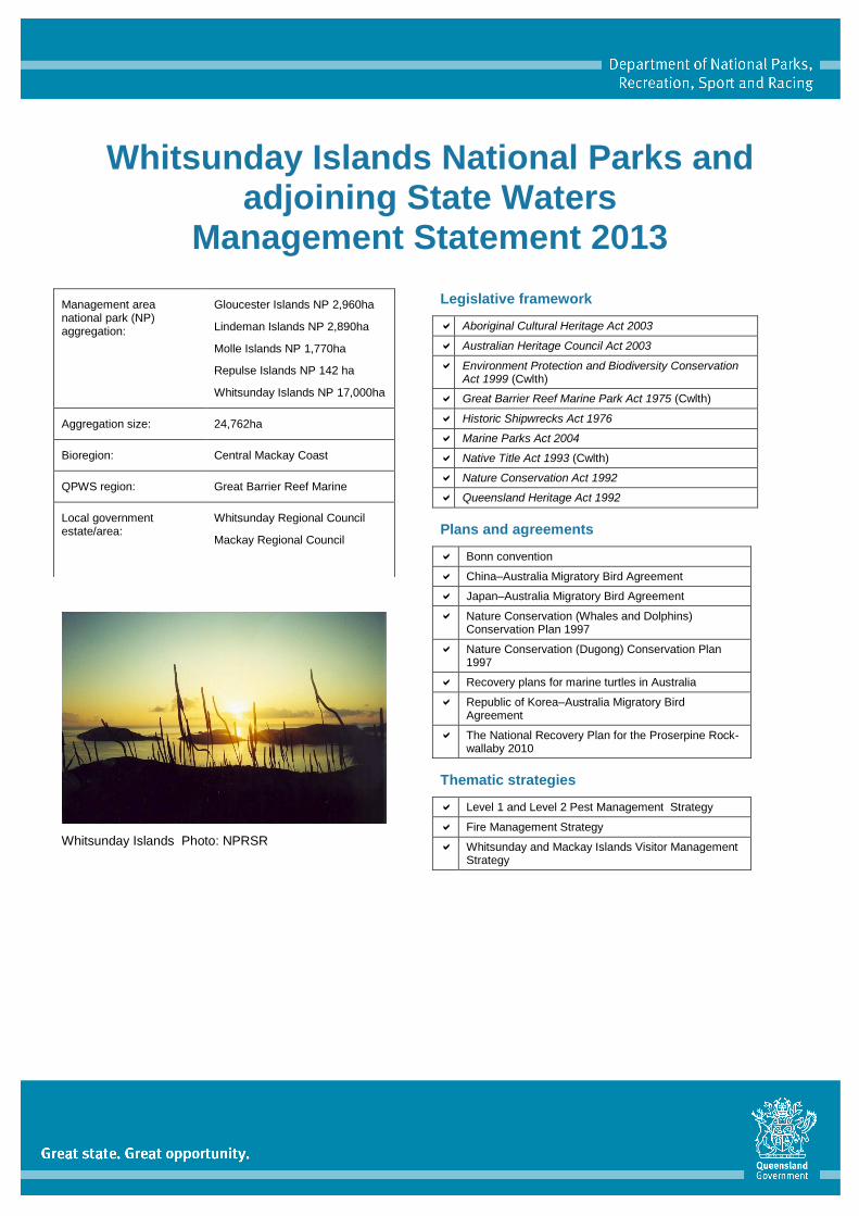
Whitsunday Islands National Parks and adjoining State Waters
Management Statement 2013
Whitsunday Islands Photo: NPRSR
Legislative framework
Aboriginal Cultural Heritage Act 2003
Australian Heritage Council Act 2003
Environment Protection and Biodiversity Conservation Act 1999 (Cwlth)
Great Barrier Reef Marine Park Act 1975 (Cwlth)
Historic Shipwrecks Act 1976
Marine Parks Act 2004
Native Title Act 1993 (Cwlth)
Nature Conservation Act 1992
Queensland Heritage Act 1992
Plans and agreements
Bonn convention
China–Australia Migratory Bird Agreement
Japan–Australia Migratory Bird Agreement
Nature Conservation (Whales and Dolphins) Conservation Plan 1997
Nature Conservation (Dugong) Conservation Plan 1997
Recovery plans for marine turtles in Australia
Republic of Korea–Australia Migratory Bird Agreement
The National Recovery Plan for the Proserpine Rock-wallaby 2010
Thematic strategies
Level 1 and Level 2 Pest Management Strategy
Fire Management Strategy
Whitsunday and Mackay Islands Visitor Management Strategy
Management area national park (NP) aggregation:
Gloucester Islands NP 2,960ha
Lindeman Islands NP 2,890ha
Molle Islands NP 1,770ha
Repulse Islands NP 142 ha
Whitsunday Islands NP 17,000ha
Aggregation size: 24,762ha
Bioregion: Central Mackay Coast
QPWS region: Great Barrier Reef Marine
Local government estate/area:
Whitsunday Regional Council
Mackay Regional Council
Whitsunday Islands National Park Management Statement 2013
2
Vision As part of the Great Barrier Reef World Heritage Area, the national parks of the Whitsunday islands and the adjoining Great Barrier Reef Coast Marine Park will preserve the islands habitats, outstanding landscapes, vegetation communities, reefs and species of State, national and international significance.
The area’s islands, marine life and fringing reef flats will be managed with an understanding of biodiversity conservation principles to ensure impacts are minimised.
Visitor facilities are in keeping with the undeveloped character of the area and concentrated mainly at key popular destinations. The national parks of the Whitsunday islands will continue to provide a natural experience for self-reliant visitors, opportunities for nature-based tourism and cultural heritage values are identified and protected.
The area’s rich marine life and fringing reef flats are will be used by scientists to improve management decisions to protect the Great Barrier Reef World Heritage Area.
Partnerships with the Traditional Owners, local community, neighbours, research institutes and conservation groups are established and will continue to contribute to the area’s ongoing management.
Conservation purpose The objectives of management for the national parks of the Whitsunday islands and adjoining State waters are to:
conserve island landscapes and foreshore quality and integrity, having regard for the high nature conservation and cultural heritage values and address any threats
protect and retain the natural integrity of native plant communities, in particular endangered and of concern regional ecosystems, and protect marine habitats, plant, animal and migratory species of national and international conservation significance and address any threats
support a diverse range of recreational experiences for international and domestic visitors, ranging from camping on remote islands through to guided group day tour operations
continue to build and enhance cooperative relationships with resorts, community, neighbours, stakeholders, Great Barrier Reef Marine Park Authority (GBRMPA), universities, conservation groups, Traditional Owners, tourism organisations, other government agencies and visitors to the area
identify knowledge gaps and encourage scientific research and monitoring that addresses these gaps and contributes to the understanding and management of the area and utilise this information to provide direction and actions to protect the natural, cultural and social values of the management area
incorporate the interests and rights of Traditional Owners by cooperatively protecting and managing cultural heritage and natural resources of significance
work with park neighbours, lease holders, commercial operators and park visitors to reduce the risk of the introduction and spread of pest plants and animals to the islands and minimise the risk of wildfires to life, property and the management area’s values
continue to maintain islands in their natural state presenting and protecting outstanding values whilst providing safe, sustainable, nature-based terrestrial and marine recreation and commercial tourism opportunities.
Protecting and presenting the area’s values
Landscape
The Whitsunday islands is the collective name given to over 75 islands, islets, and rock outcrops in the area from Gloucester Island near Hydeaway Bay in the north, through to Repulse Islands in the south. The largest islands of the group are Whitsunday (10,900ha), Hook (5,180ha), Gloucester (2,656ha) and Shaw (1,660ha) with all others being under 1,000ha. Gloucester Island has the highest peak (577m). The islands are in aqua-blue oceanic waters with characteristic white swirling sands that make picturesque places world renowned such as Whitehaven Beach, and are not far from large patch reefs of the central Great Barrier Reef.
The continental islands represent the peaks of a submerged range complex that became inundated at the end of the last ice age. Many islands and island groups have stunning geological topography features including deep water inlets, steep rugged cliffs, rocky peaks and outcrops. Sheltered bays and quiet sandy beaches provide a range of habitat and vegetation communities and add to the spectacular scenery. There is a high probability that some species on the islands have evolved special genetic characteristics within the existing plant and animal communities as is recorded on Whitsunday Islands National Park. The isolated continental islands show a high degree of endemicity, with unique species and sub-species of plants and animals having recently been discovered giving the area high research value and potential.
Whitsunday Islands National Park Management Statement 2013
3
The area’s landscapes and seascapes support a variety of important nesting and feeding habitats for species of conservation significance such as turtles and dugong, and migratory routes and calving grounds for marine mammals. Isolated and relatively undisturbed islands are important to a number of threatened coastal bird species. Fringing coral reefs are also found around most of the islands and provide easily accessible and sheltered viewing opportunities for a large commercial tourism fleet. There are a number of intertidal wetlands and fringing mangrove communities on and around islands that provide habitat and nurseries for fish and crustaceans, buffer estuaries from sediments and coastlines from storms, natural nutrient filters and critical habitat for many birds and wildlife.
Regional ecosystems
The national parks of the Whitsunday islands are located in the Interim Biogeographic Regionalisation for Australia Central Mackay Coast Bioregion, with a small representation of Brigalow Belt bioregion community in Gloucester Islands National Park. Vegetation on the islands includes low, closed shrublands and woodlands, mixed vine forests, open heath, lowland rainforest and coastal headland grasslands. The surrounding Great Barrier Reef Coast Marine Park contains significant habitats including fringing coral reefs and sea grass habitats. Salt flats, sea-grass meadows and mangrove forests occur in intertidal areas.
The islands have a wide range of habitat types. Whilst dominated by vine forest the islands also host woodland and grassland areas. Seasonal drainage lines are generally dominated by rainforest species. The area contains low altitude rainforest with and without hoop pine. This type of rainforest is restricted to the Central Queensland coast.
The national parks of the Whitsunday islands conserve a wide range of regional ecosystems, including seven endangered and 11 of concern (Table 1). Significant vegetation in the area includes the Environmental Protection and Biodiversity Conservation Act 1999 (EPBC) critically endangered community littoral rainforest and coastal vine thickets of eastern Australia (beach scrub).
Some ecosystems are endemic to these islands. The endangered regional ecosystem (8.3.5) containing Clarkson’s bloodwood Corymbia clarksoniana, swamp mahogany Lophostemon suaveolens, popular gum Eucalyptus platyphylla woodland on alluvial plains is restricted in the Whitsundays to Gloucester Islands National Park. South Molle Island and Saddleback Island support an example of an endangered ecosystem (8.2.9) containing Heteropogon triticeus, blady grass Imperata cylindrica and Themeda triandra grassland on coastal dunes. This ecosystem occurs on large high aeolian deposits, and is rare. This is the only grassland regional ecosystem on sand dunes in the Queensland Central Queensland Coast bioregion. Regional ecosystem (8.3.2) containing Melaleuca viridiflora woodland, which is endangered, is restricted in the Whitsundays to Lindeman Islands National Park. The low vine scrub of Armit Island and other northern islands of the Gloucester group represent a type being rapidly depleted on the mainland.
Regional ecosystem (8.2.8b) of variable eucalypt open-forest to woodland often with heathy elements on parabolic dunes and beach ridges is geographically restricted to one locality on Whitehaven Beach on Whitsunday Island. Of particular significance is the lack of data on geographically restricted ecosystems such as this dune system west of Whitehaven Beach; the lack of knowledge on this ecosystem and its prescribed burn requirements are a major obstacle for effective fire management.
General threats to the regional ecosystems include the invasion of pest plant and animal species and the threat of wildfire or inappropriate prescribed burn regimes for sensitive vegetation communities. Impacts from visitors include vegetation removal, compaction and trampling, soil and dune erosion, and accidental spreading of pest plants with impacted areas generally restricted to beach and fore dune areas and areas adjacent to walking trails. High use visitor areas such as Tongue Point and Lookout Beach and areas adjacent to developed resorts on South Molle Island, Lindeman Island, Long Island and Hook Island are impacted to a greater extent as visitors act as vectors in the introduction and spread of pest plants.
Many of the islands natural ecosystems have been altered due to historic grazing and are in a recovering stage. The cessation of grazing has allowed the return of some affected species; however recovery of the natural populations of plants and animals may take decades. Modification of native grasslands appears to be occurring with forest trees expanding through changed fire regimes.
Native plants and animals
The national parks of the Whitsunday islands and the adjoining State waters are part of the Great Barrier Reef World Heritage Area inscribed to the World Heritage list in 1981 as Australia’s first World Heritage area. Species of conservation significance are found throughout the management area. The importance of biodiversity conservation on isolated marine islands in the Great Barrier Reef World Heritage Area is an important management objective.
The islands contain pockets of significant and rare vegetation. The vegetation on the islands has been mapped from aerial photography, but has not been comprehensively ground truthed. Information gaps have been identified and future surveying and research of the area is encouraged.
Whitsunday Islands National Park Management Statement 2013
4
Vegetation mapping indicates significant species and plant assemblages (tables 1 and 2). There are 19 plant species of particular conservation significance because they are endangered, vulnerable, or of concern under the Nature Conservation Act 1992 (NCA) (Table 2) as well as many endemic species of interest occurring in the management area. Eighteen vegetation communities are of conservation significance for their threatened status (Table 1). Stands of hoop pine Araucaria cunninghamii are characteristic of the islands.
Croton magneticus—a vulnerable species—occurs on Hook, Whitsunday and Gloucester islands and is restricted to dry rainforest on granitic substrates. Omphalea celata—a vulnerable species—occurs on Gloucester Island in melaleuca open forest or woodland. Ozothamnus eriocephalus is a vulnerable species found only on Gloucester Island in dry tropical rainforest. Trigonostemon inopinatus is a vulnerable species found on Whitsunday Island in semi deciduous notophyll/mesophyll vine forest fringing water courses.
Endemic plants to the Whitsunday region include:
Argyodenrdron sp. occurring in rainforest
Brachychiton compactus near threatened and endemic to Whitsunday region occurring in rainforest and rocky headlands
Capparis sp. near threatened and endemic known only from northern granitic sites of Gloucester island
Gossia pubiflora endemic to Whitsunday region occurring in rainforest
Homalium sp. found on Hook, Hayman, Whitsunday and South Molle islands, endemic to Whitsunday region found in low microphyll/notophyll vine forest with emergent Araucaria cunninghamii.
Biosecurity and preventative measures to reduce the risk of pest transmission to the islands presents an ongoing management challenge and priority. Native plants and animals of the islands can be significantly impacted in the event of a feral species invasion. Pests can be introduced to resort and leased areas through barge materials and transmission through park users. Pests when present in adjacent areas on the mainland can easily infest the islands by being transported by natural carriers such as birds, wind, and water currents. The major management activities that will aid in maintaining native plant species diversity and numbers are upholding strong biosecurity and pest hygiene provisions, the control of existing pest plant and animal species and implementing appropriate fire regimes.
The management area is rich in animal species, with at least 26 species of conservation significance (Table 2) and many migratory species listed in international agreements (Table 3). The area is home to a variety of protected species including whales, dolphins, dugong, turtle, bats, shorebirds and seabirds. The marine area is an important humpback whale Megaptera novaeangliae calving ground and migration route on Australia’s east coast. The little tern Sternula albifrons and the loggerhead turtle Caretta caretta are listed as endangered under the NCA and identified as priority species under the Back on Track species prioritisation framework (BoT). Nine animal species are listed under the EPBC (Table 2).
Gloucester Island contains the only national park island with a natural population of the endangered Proserpine rock-wallaby Petrogale persephone.The presence of Proserpine rock-wallabies on Gloucester Island represent a significant opportunity to monitor an isolated island population of this species free from predation and impacts of habitat modification. There is potential that introduced toxic plant species (being a dangerous food source or competing with desirable food sources for the wallaby), as well as its genetic isolation have impacted on the island population’s viability. Queensland Parks and Wildlife Service (QPWS) and partners will continue research and monitoring of the Proserpine rock-wallaby and its habitat requirements. The Australian Government in partnership with the State have prepared the National Recovery Plan for the Proserpine Rock-wallaby 2010. QPWS will facilitate actions needed for the conservation of the threatened species and recovery efforts throughout the species range. Additionally, the occurrence on Whitsunday Island of the unadorned rock-wallaby Petrogale inornata is significant as this is the only natural island population of this species. Further it has been isolated for several thousand years and may be genetically distinct.
A number of islands and rocks in the Whitsundays are important for seabirds, shorebirds and several migratory species and provide habitat to birds of State, national, and international conservation significance (tables 2 and 3). The area has a high diversity of bird species and supports feeding and occasional nesting habitat for migratory species including several migratory species listed in the Japan–Australia Migratory Bird Agreement, China–Australia Migratory Bird Agreement, Republic of Korea–Australia Migratory Bird Agreement, and Bonn Convention that visit the area to feed and rest. Migratory coastal birds make long annual flights between their international breeding grounds (China, Japan, Korea and northern Russia) and Australia where they spend their non-breeding season (September to April). Threats known to affect migratory coastal birds include coastal development, human disturbance and predation.
The management area is important for resident coastal birds, such as vulnerable beach stone-curlews Esacus magnirostris (Back on Track priority species) as well as near threatened eastern curlews Numenius madagascariensis, and sooty oystercatchers Haematopus fuliginosus. Like many coastal birds, protecting nesting, roosting and feeding sites from human disturbance is vital.
Whitsunday Islands National Park Management Statement 2013
5
Some islands and mainland areas adjacent to the management area are major sea bird rookeries. Tern species including crested terns Thalasseus bergii and bridled terns Onychoprion anaethetus, nest on Eshelby and Holbourne islands. Numbers of nesting seabirds are generally low; however the management area provides important feeding grounds and occasional nesting for many species. Iconic white-bellied sea-eagles Haliaeetus leucogaster and eastern osprey Pandion cristatus nest on isolated small islands and rocks and are vulnerable to disturbance; additionally raptors are adversely impacted by people feeding the birds. Because roosting and nesting birds are very vulnerable to disturbance, several sites have been identified needing special management (refer to Great Barrier Reef Marine Park Authority – Whitsundays Planning Area Settings Map). Annual closures of beaches and islands, and seasonal closures between 1 October – 31 March, are in place for significant bird sites. Management arrangements applying to significant bird sites include a six knot speed limit within 200 metres of the low water mark, no aircraft allowed below 1,500 feet (above ground or water) or to approach within 1000 metres, and, where nesting species are most easily disturbed by noise, a ‘boat-free zone’ (within 200 metres of the high water mark) applies. Future management planning aims to align access restrictions for protected terrestrial areas, intertidal (State) waters and adjacent (Commonwealth) waters.
The Whitsundays are an important calving ground for humpback whales between May and September each year. Most of the waters around the islands are part of the whale protection area designed to minimise disturbance to cows and calves. Other near threatened marine mammals, such as snubfin dolphins Orcaella heinsohni and Indo-pacific humpback dolphins Sousa chinensis, also occur throughout these waters. To help protect marine mammals in the Whitsundays region, there are rules for boating and whale and dolphin watching regarding approach distance. The Nature Conservation (Whales and Dolphins) Conservation Plan 1997 and Nature Conservation (Dugong) Conservation Plan 1997 manage the approach distance for whales and marine animals:
Inside the whale protection area, boats and people must not approach within 300 metres of a whale
Outside the whale protection area, boats must not approach within 100 metres of a whale
Outside the whale protection area, if there are already three vessels within 300 metres of a whale, all additional vessels must remain outside a 300 metre radius from the whale.
Dugong populations in the southern Great Barrier Reef are severely depleted and both dugong Dugong dugon and turtles are under pressure from habitat loss, gill netting, illegal or unsustainable hunting and boat strikes (GBRMPA 2009). The marine seagrass areas in the management area are important dugong foraging areas. To help protect dugong, a dugong protection area is located in northern Repulse Bay and Edgecombe Bay to the west of Gloucester Island, and restrictions apply on the use of mesh nets in this area.
The Whitsunday area is an important turtle feeding ground and many species of sea turtle can be found including green turtles Chelonia mydas, hawksbill turtles Eretmochelys imbricata, flatback turtles Natator depressus, loggerhead turtles Caretta caretta. The loggerhead turtle is listed as endangered under the NCA and EPBC and identified as critical priority species under the BoT framework. The Queensland coastline is critical to the long-term survival of the endangered loggerhead turtles, particularly for nesting and inter-nesting habitats (Environment Australia 2003). Loggerhead turtles migrate through the area on their way to and from nesting sites in the Capricorn–Bunker region, although individual turtles may also live in the planning area.
While not largely significant for marine turtle nesting, this section of coast provides important foraging and inter-nesting habitat for turtles on Australia’s east coast (Limpus 2009). Flatback turtles are currently listed as a vulnerable species under the NCA and EPBC. Flatback turtles are also identified as high priority species under the BoT framework. Flatback turtles live in the deeper waters between the islands and reefs and also nest in low numbers within the planning area. Nesting for flatback turtles is restricted to Australian waters and is considered to occur in low numbers in the management area; however the cumulative total could be of importance for flatback turtles where only a limited number of nesting islands are known (C. Limpus 2007). Green turtles Chelonia mydas and hawksbill turtles Eretmochelys imbricata also forage in the area and sporadic and incidental nesting may occur. The Whitsunday islands are generally thought to be the southern-most extent of hawksbill nesting areas on Australia’s east coast.
The main threats to these turtle species are coastal development, water pollution, marine debris ingestion, recreation activities, predation of eggs by introduced species, entanglement from discarded nets and fishing gear, shark nets, boat strikes, light pollution, and smothering of seagrass beds by sediment (GBRMPA 2009; Limpus 2007). Visitor disturbance is a particular threat in summer and autumn during the nesting and hatching season and seasonal closures map apply to some beaches such as Steen’s Beach on Hook Island.
The coastal sheathtail bat Taphozous australis—a vulnerable species under the NCA (BoT high priority species)—inhabits a narrow coastal zone including islands in the Whitsundays and is threatened by coastal development and loss of habitat. Flying-fox communities can be found on Lindeman Island, South Molle Island and other locations in the area. The common death adder Acanthophis antarcticus is a near threatened species under the NCA and is particularly threatened by cane toad introduction. The presence of king brown snakes Pseudechis australis on Gloucester Island is significant for the species in an island location.
Whitsunday Islands National Park Management Statement 2013
6
The Whitsundays islands contain many endemic species, and sub species worthy of additional research and study. A species of land snail Varohadra macneilli found on Double Cone Island along with two other species of snail are thought to be endemic to the Whitsunday islands. A small litter dwelling rainbow skink Carlia pectoralis inconnexa is endemic to the Whitsunday Island group. The endemic leaf tail gecko Phyllurus spp. was recently discovered as a new species on Whitsunday Island. The giant burrowing cockroach Macropanesthia rhinoceros has a restricted distribution and are found in dry eucalyptus scrubland of northern Queensland, Cape York to Rockhampton and the Whitsunday islands.
The fringing reefs formed around the islands of the Whitsundays are diverse and support an abundance of reef life including corals and fish. Surveys of fringing reef locations in the Whitsundays conducted in 1995 particularly identified the reefs of Gloucester Island as outstanding in terms of species richness, coral cover and aesthetic appeal (De Vantier and Turak 1995). A few reefs in the management area are showing signs of impacts, such as near Lindeman Island, Daydream Island and in Shute Bay.
The major management themes that will assist in maintaining species diversity and numbers are the control of pest plant and animal species and appropriate fire regimes. By maintaining biosecurity measures to prevent the introduction of feral species such as tramp ants, cane toads, and also soil organisms, myrtle rust or other diseases, the risks that threaten native flora and fauna are reduced.
Aboriginal culture
Traditional Owners are an important part of effectively managing the area as they have a strong role to play in continued involvement in its cultural and sustainable use. The relationship of Traditional Owners with their country is a special one, and the whole landscape has important value to them. The islands of the Whitsunday area have cultural significance for the Gia, Juru, and Ngaro people who were sea country specialists using the rich marine resources of the intertidal zones, fringing reefs, and surrounding seas to support their community. The Yuiberra people have lodged native title claim QC98/37 around the Mackay region, both land and sea areas.
Pre-historic sites including shelters, artefacts, shell and stone scatters, and art sites are found throughout the islands. A formal archaeological survey of some of the islands has been conducted and recorded; it is thought many additional sites exist. The earliest evidence of occupation in the Whitsunday islands by the Ngaro people dates to before 9,000 years ago at Nara Inlet on Hook Island (Barker 2004). An increase in the use of sites in the Whitsundays area occurred from approximately 3,000 years ago, encouraging specialised use of marine resources with the development of fish hooks, fish traps, outrigger canoes, hunting of dugong, marine mammals and turtles (Barker 2004). Evidence suggests that during this period people were occupying or visiting nearly all of the islands in the Whitsunday area as evidence has been found of pre-historic use of most of the smaller islands clustered around Hook and Whitsunday including Hayman, Border, North Molle, Daydream, Shute, Long, Cid, Dent, Lindeman and South Repulse islands (Barker 2004).
Marine resources predominate in all sites which have been excavated in the Whitsundays; the Ngaro and their ancestors can thus be characterised as operating a marine economy as maritime hunter gathers (Barker 2004). Interpretive signs present and inform visitors of the area’s cultural values, sites and artefacts including middens, cave paintings and fish traps. Hook Island has many rock shelter sites having deep stratified deposits of cultural material. The most significant site is on Hook Island in Nara Inlet, where a large midden and cave painting is located, walking tracks allow access and interpretation signs present this significant cultural site to visitors. The site is significant to all Australians and Traditional Owners as an irreplaceable example of the nation’s cultural heritage. It provides a unique opportunity for visitors to view and appreciate an important archaeological site.
South Molle Island contains supporting evidence for a long history of systematic exploitation of quarry rock, a source for tool making; use of the site is dated from before 9,000 years ago (Barker 2004). Once known by Traditional Owners as Whyrriba or ‘stone axe’, the quarry rock that yielded good cutting stones covers a large area on the steep ridge on the east side of the island and is of extraordinary significance within the region and is unique in terms of Australian pre-history (Blackwood 1997). Implements and artefacts from South Molle Island quarry site have been found in Nara Inlet on Hook Island and at other sites throughout the islands (Barker 2004).
It is envisaged that Traditional Owners will continue to work cooperatively with QPWS to develop strategies and guidelines to conserve and manage the area’s Aboriginal cultural heritage and natural resources. Given the area’s cultural richness, there is potential that additional cultural sites will be discovered. Consultation with Traditional Owners about managing and protecting their heritage will continue. This consultation aims to strengthen cultural connections and ensure appropriate measures are taken to protect known cultural places. QPWS and Great Barrier Reef Marine Park Authority will work closely with Traditional Owners, Aboriginal and Torres Strait Islander peoples and other relevant groups to ensure that traditional use of marine resources are managed at sustainable levels.
Whitsunday Islands National Park Management Statement 2013
7
Shared-history culture
Many historical accounts record a long history of use of the islands dating from European settlement to the present with many of the islands having seen attempts of settlement beginning in the late 1800s for grazing, timber harvesting, homestead and tourism leases.
The prominent stands of hoop pine first attracted the attention of foresters to the area—in the 1870s harvesting operations commenced. Hoop pines were cut from Cid Harbour, Gulnare Inlet and Hook Island from 1870 to 1901. The largest operation existed at Cid Harbour. Grasslands and good soil of the Molle group, Lindeman Island, Haslewood and a few others attracted the attention of early settlers, and a period of sheep grazing and attempted pastoral activities followed. The focus gradually changed to tourism—in 1927 the first tourism resort was established on Lindeman. Other resorts followed starting with Hayman in 1932 and continuing with resorts on South Molle, Daydream (West Molle), and Long islands. National park declaration of some islands started in 1940s. Tourism is now the predominant economic use of the area.
Shared history of the Whitsundays in general includes:
association through names with European discovery by Lieutenant James Cook in 1770, Commander Nares in 1866 and others
ship wrecks
early encounters between native inhabitants and new settlers
tramway and relics of timber harvesting sawmill days, on Sawmill Beach and Gulnare Inlet
relics of a limestone mine on East Repulse Island
the USA 7th fleet anchored in Cid Harbour during the second World War
the Dent Island Light-station is on the Register of the National Estate under the Australian Heritage Council Act 2003
settlement history of grazing and pastoral activities on the islands
settlement and development history of the growth of the tourist resorts each with its own family background.
Much of the European settlement history of the Whitsundays is not represented by tangible remains but many references detail settlement and history of the area recording this history.
Tourism and visitor opportunities
The national parks of the Whitsunday islands and adjoining State waters provide for low-impact, remote, nature-based recreation and appreciation of the area’s natural, cultural and scenic values. Visitors can expect a remote and natural experience when visiting the management area. Visitors will encounter relatively undeveloped islands with basic facilities and a variety of walking tracks to panoramic peaks with highly scenic views. The area’s values are presented to visitors through a number of communication mediums including on-site information shelters, interpretation signs, pre-visit brochures and park guides. Recreational opportunities include picnicking, bushwalking, wildlife and bird watching, camping, photography, along with water-based activities such as reef appreciation activities, diving, snorkelling, fishing, scenic boating and yachting. Towns along the Whitsunday coast such as Airlie Beach, Dingo Beach, Hydeaway Bay, Shute Harbour, Conway Beach and Midge Point provide boat launch facilities and access to the national parks of the Whitsunday islands.
A range of walking trails, including the Ngaro sea trail, provide easy to challenging bush walking opportunities on Whitsunday Island, South Molle Island, Long Island, Lindeman Island, Seaforth Island and Hook Island. The extensive walking track system of South Molle Island and Long Island supports access to the park by resort guests, campers and day visitors. There are numerous (approximately 25) sites where camping is allowed on the islands. These camp sites, along with additional day use sites, are supported by basic visitor facilities. Generally, visitors are to be self-reliant when visiting the parks. Camping permits are required and are available online or over the phone. To protect coral reefs and sensitive marine habitats from impacts, a series of public moorings complemented by ‘no anchoring areas’ are being maintained. Vessels are required to follow mooring guidelines and no anchor area restrictions.
Whitsunday Islands National Park Management Statement 2013
8
The Whitsunday and Mackay Islands Visitor Management Strategy 2007 assists in ensuring that tourism is being developed with environmentally sustainable principles, the region’s values professionally presented, visitors have a rewarding experience, and the QPWS partner organisations and tourism industry work together effectively. The strategy provides a framework for sustainable tourism and visitor use by applying a system of visitor management settings to island visitor sites to guide management decisions, permit assessments, site planning, facility development. Through implementation of the strategy it is an aim that a diverse range of recreational opportunities for commercial operators and independent visitors are available.
Commercial tourism activities in the World Heritage area’s marine and national parks are managed by QPWS and GBRMPA. Commercial tourism use is largely managed through a permitting system. More generally, activities and uses across the marine park are guided by zoning provisions. Multiple use zoning provides for activities including fishing, snorkelling, shipping and research. Zoning plans define the activities that can occur in specific locations to protect the marine environment and separate potentially conflicting activities. Zoning plans balance human use with conservation of the marine parks.
Under the complementary Whitsundays Plan of Management (GBRMPA) and the Whitsunday and Mackay Islands Visitor Management Strategy, settings have been assigned to land and marine areas to provide for a range of recreational opportunities throughout the Whitsundays. Some islands and sites are set in a natural and protected setting which protects sensitive habitats, reflects current use and indicates that future use will be focused on low levels of visitor use with limited facilities and free from larger vessels and commercial activities. Commercial activity permits for operators are issued for day visits and camping at some sites where appropriate visitor facilities exist. To satisfy visitor expectations and protect the integrity of the park, visitor management will maintain a complete range of recreational opportunities within the Whitsundays from passive nature based experiences to higher use commercial tourism sites.
Education and science
Many of the islands have high biodiversity values and conserve many species of global conservation significance. The management area offers learning opportunities in geology, biology, ecology, marine studies, and Aboriginal cultural heritage. Public education increases community awareness of the area’s values, conservation principles and practices.
The management area provides abundant opportunities for scientific research and monitoring. Results from research and monitoring can benefit the area’s management in filling knowledge gaps, and educate staff and the community. Previous and ongoing research includes vegetation and fauna surveys, bird count surveys, surveys for dugong and turtles, cultural site surveys, reef health impact surveys and visitor monitoring programs.
Ongoing research and monitoring programs are valuable to establish and incorporate into adaptive park management. Research has been limited by logistics of access to the area; however, participation and information sharing with research institutions is highly encouraged. Topics for potential research and where knowledge gaps have been identified include comprehensive native plant and animal surveys for islands, including focus on special endemicity value of the area; habitat requirements and population trends for endangered, vulnerable and near threatened species; cultural heritage site location and management; and sustainable tourism in protected areas.
Partnerships
QPWS is directly responsible for planning, managing and regulating activities in the management area. QPWS needs the support of the local community, Traditional Owners, visitors and interest groups if the vision for the management area is to be achieved. Efficiencies in resource sharing, improved communications, decision making and enhanced on-ground outcomes is to be facilitated, where possible, through working partnerships.
A strong working relationship with the Great Barrier Reef Marine Park Authority assists with unifying operational management of the adjoining Great Barrier Reef Coast Marine Park, Great Barrier Reef Marine Park (Commonwealth) and Great Barrier Reef World Heritage Area.
A working relationship with the Traditional Owners is essential so that their views and aspirations for the land and surrounding waters can be included in planning and management. To achieve effective management of the area, QPWS strives to work closely with other government departments in undertaking joint compliance patrols, and maintaining a strong communication network with the tourism industry and natural resource management groups.
Pest management
Pest plants and animals have been introduced to the islands through historic grazing uses and resort development, garden escapees, and by wind and birds, incidental transport, visitors and barge materials, and by proximity to pest-affected mainland areas.
Whitsunday Islands National Park Management Statement 2013
9
Pest management strategies have been developed to prioritise regional pest plant and animal controls, guide operational work plans and evaluate program effectiveness on managed estates. A Level 1 pest management strategy for the Central Queensland region (marine parks) guides pest management programs across the region. A Level 2 pest management strategy is in place for the management area. Ongoing operations management and monitoring is a recognised priority for pest management effectiveness, as is education to park users and neighbours in reducing the spread of pests.
Most islands in the Whitsundays are relatively free from pest plants, with notable exceptions being those that were former grazing leases or were occupied for other purposes after European settlement of the area. Isolated infestations can be found in campgrounds, day use areas or other recreational areas frequented by visitors. Other areas where pest plants occur were likely spread by water currents, animals, bird droppings or wind.
Sparse to dense infestations of Lantana Lantana camara occur across the management area which can form impenetrable thickets, smother native vegetation, decreasing biodiversity and lead to changes in fire intensity and frequency. Several sparse to dense infestations of prickly pear Opuntia spp. occur along the coastline of various islands, particularly on the Molle, Gloucester, and Double Cone islands. Spot infestations of rubbervine Cryptostegia grandiflora are also present on Middle and Lindeman islands and along the western coast of Gloucester Island. Rubbervine is a vigorous woody climber that can smother vegetation, form dense thickets and alter vegetation structure.
Of particular management and operational interest are campgrounds, tracks and lease areas at South Molle Island, Long Island and Lindeman Island. Here many pest species are present due specifically to human impacts. Many pest plant species found on these islands’ leased areas pose a significant threat to adjacent park areas and neighbouring islands through translocation by wind, water, visitors or birds. Pest plants impact on bird and turtle nesting habitat on the islands, and alter native vegetation communities. QPWS aims to develop and maintain a cooperative working relationship with neighbours and stakeholders aimed at controlling pest species. Additionally, pest management will focus on controlling and eradicating where possible emerging pest species particularly grasses, woody and shrub species such as rubbervine, mission grass Pennisetum polystachion, grader grass Themeda quadrivalvis, giant rat’s tail grass Sporobolus pyramidalis and S. natalensis. Quarantine and hygiene practices will be important considerations in managing potential threats such as myrtle rust.
Through a long history of grazing, agriculture and tourism several introduced animal species currently post a threat on a few of the national park islands of the Whitsundays. The inadvertent transport of plant and animal pests, and maintaining biosecurity provisions is an ongoing concern owing to the close proximity of some of the islands to the mainland and frequency of use of resort and visitor areas.
Past pest management efforts have proven successful with the eradication of several species from the islands in recent times. Sheep Ovis aries, cats Felis catus and feral chickens Gallus gallus domesticus have been eradicated from South Molle Island. Goats Capra hircus have also been eradicated from North and South Molle islands, Lindeman Island, North, South and East Repulse islands.
Feral pigs Sus scrofa (Class 2) are found on Long Island and possibly on Haselwood Island. Pigs are capable of threatening native species and ecosystems by changing ecosystem structure, direct predation on threatened species i.e. turtle eggs, and causing damage by extensive digging in critical habitats. A pig population on Haselwood Island is thought to have originated from a piggery established on the island in the early 1900s. Minimal pest management has occurred at Haselwood; however semi-regular inspections of coastal mudflats confirm no recent pig activity. Coordination with the stakeholders on Long Island is essential as there are three separate resort leases on the island. Long Island’s close proximity to mainland makes it possible for re-introduction by animals (particularly pigs) swimming across the <1km channel.
Feral goats (Class 2) are found on Hook Island and Long Island. Feral goats impact upon native vegetation communities, in particular beach and vine scrubs, hoop pine and sclerophyll forests. Additionally, goats can impact on cultural sites. Goats threaten biodiversity by influencing the variety and abundance of native plant species, spread weeds, and cause erosion. Considerable effort has reduced numbers on Long Island to the point of possible eradication. Ongoing monitoring is required to confirm eradication. The origin of goats on Hook Island is from Arthur Abell in 1910 for camp and logging operation in which the goats were released on completion. Goat management is ongoing but remains difficult due to the access constraints and extremely rough terrain.
Agile wallabies Macropus agilis are found on Long Island as an introduced species. Their grazing pressure has contributed to a change in vegetation community structure and fire intensity. The wallabies were originally introduced by the resort 30 years ago; low predation has ensured a stable to increasing population.
Cane toads Bufo marinus are found on South Molle Island, Lindeman Island and Shaw Island as an introduced species and are poisonous to native wildlife when ingested. Their origins were likely by accidental introduction from the mainland in shipping materials. Cane toads pose a particularly high threat to the death adder Acanthophis antarcticus, a near threatened species under the NCA.
Whitsunday Islands National Park Management Statement 2013
10
Black rats Rattus rattus are found around the resort areas on Lindeman Island, South Molle Island and Long Island. Rats prey on bird eggs, spread disease, damage native vegetation seed stock, impact on bird and reptile nesting and habitat, and cause a nuisance to park visitors. Origins are likely to be accidental introduction from the mainland.
Ongoing monitoring as part of the pest management strategy enables evaluation of the control effectiveness and extent of damage to threatened species, ecosystems or habitats. Education of park visitors, resorts and lease holders, and commercial operators on reducing the threat of spreading and introducing pest species is essential to protecting the integrity of the national parks. Emerging risks include tramp ants, soil organism introductions and myrtle rust. QPWS and partners are working towards development of an island bio-security communication strategy to support a reef-wide program.
Fire management
A fire management system has been adopted statewide by QPWS which is the primary agency for fire management on protected areas. Fire management strategies provide the overall framework and direction for fire management and are the foundation from which planned burn programs are developed. A fire management strategy exists for the Whitsunday islands aggregation. In general the main objective of this fire management strategy is to minimise the risk of wildfire entering or leaving the protected area and threatening neighbouring resorts, protect fire sensitive vegetation, and maintain the natural role of fire as an ecological process in fire adapted vegetation communities. On islands where national park abuts freehold or leasehold property the primary objective will be protection of life and property. Additional fire protection zones will surround areas where cultural sites are found or visitor facilities and infrastructure exists. Fire is also used for control of certain weeds in some areas.
Hazard reduction burning has been done on a regular basis with the cooperation of the neighbouring lessees where there is a threat of wildfire entering or coming from the leased area. While the responsibility for maintaining fire breaks lies with the resorts, QPWS readily provides technical advice. The parks are under threat of wildfire from campfire escape.
Fire has been an ecological factor in the Whitsundays by Traditional Owner in their use of the islands. The extensive areas of grasslands may have originated through fire but this is uncertain. However, it is certain that fire has maintained these areas and without regular burning they would convert to shrubland and forest. Grazing pressure in the past has encouraged the introduction of several pest plant species and may have influenced native species composition of the grasslands. Many of the island landscapes and vegetation communities have been extensively altered by historic grazing and are still in recovery stages such as South and North Molle islands, therefore fire management practices have been modified accordingly to encourage return to a ‘natural’ state.
Authorities under the Nature Conservation Act
The national park islands provide the scenic backdrop for many tourist activities in the area. The resorts of the Whitsundays are an integral part of the recreational opportunities available to visitors in the area. The resorts provide a range of facilities and activities and cater for many visitors and complement the opportunities within the management area. Many resorts have leases over national park areas, or are adjacent to national parks. Resort developments can directly and indirectly affect the natural and cultural values in the area. Resorts with leases on national park for tourism purposes have special conditions in their authorities or deed of agreements with QPWS to manage and protect national park values. Resorts which currently have all or part of their infrastructure located on national park islands include South Molle Island, Long Island–Paradise Bay, Long Island–Happy Bay, Long Island–Palm Bay, Hook Island and Lindeman Island. Note that Daydream Island, Hayman Island, Hamilton Island and Dent Island are not part of the national park estate, but are located adjacent to marine park areas.
Authorities over national park usually provide for service infrastructure which supports the operation of the resort such as access roads, airstrips and power, telephone and water utilities.
Telstra Corporation Limited has communication towers located on South Molle Island and Whitsunday Island. Authority under section 35 of the NCA provides the mechanism to allow Telstra access for establishing, operating and maintaining a communication tower.
Volunteer Marine Rescue and Maritime Safety Queensland operate a tower at Mount Robinson on Whitsunday Island. The authority provides the operators and its contractor’s access for establishing, operating and maintaining a communication tower. Access for these operations is only undertaken by helicopter, using the designated helipad in the authority area.
Whitsunday Islands National Park Management Statement 2013
11
The Australian Maritime Safety Authority has direct interest in operating automated lighthouses, navigation aids and affiliated infrastructure in the management area. Marine navigation interests on Eshelby Island—a Commonwealth Island—have been formalised by an agreement with the Commonwealth, with QPWS involved in day-to-day management outlined in the field management program. A section 35 authority provides access for establishing, operating and maintaining marine navigation uses in Whitsunday Islands National Park on Hook Island which also has an associated landing pad, and on Edward Island, as listed in Schedule 2 of the Nature Conservation (Protected Areas) Regulation 2006.
Marine infrastructure
Facilities associated with marine activities in the management area include marker buoys, moorings, jetties, navigational aids, marinas, pontoons, artificial reefs, fish aggregation devices and shipwrecks. The installation of these marine facilities is done under permit with consideration of the location and to sensitive sites.
Public moorings have been installed in some locations to protect coral from anchor damage and water turbidity while enhancing public access to popular bays. In addition to public moorings, reef protection (no anchoring) markers are used at some locations to protect reefs from anchor damage. The reef protection program in the Whitsundays includes approximately 84 public moorings and 45 reef protection markers.
Reef Health Impact Surveys (RHIS) are conducted to monitor fringing reef communities at popular anchorages and infrastructure.
Reef water quality protection
The Reef Rescue Marine Monitoring Program monitors the condition of water quality and the health of key marine ecosystems such as coral reefs and seagrass. The Reef Water Quality Protection Plan (reef plan) is a joint commitment of the Australian and Queensland governments. The marine monitoring program is a key component in the assessment of long-term improvements in inshore water quality and marine ecosystem health that are expected to occur with the adoption of improved land management practices in the reef catchments under reef plan and reef rescue.
One successful outcome from this program has been the requirement for island tourism operations to manage their sewage to tertiary level. Accordingly QPWS has implemented a range of sewage treatment options for the campground facilities to ensure nil discharge to the marine environment.
Coastal and industrial development in areas adjacent to the management area is occurring and planned to increase in the near future such as Abbot Point coal terminal expansion, Hay Point coal terminal and the mining expansion in the interior basins. Shipping traffic will increase within the management area and the Great Barrier Reef in general resulting in increased disturbance to wildlife, increased risk of boat strike, risk of pest species or disease introduction, turbidity and sediment deposition from dredging. Coral and seagrass areas are under threat; the risk of an oil spill or shipping accident holds particularly high impact potential to rocky coasts, corals and marine areas in the management area. Management aims to proactively plan for effective mitigation and have contingency measures in place in the event of an incident.
Whitsunday Islands National Park Management Statement 2013
12
References Barker B 2004, terra australis 20 The Sea People: Late Holocene maritime specialisation in the Whitsunday Islands, Central Queensland. Pandanus Books
Blackwood R 1997, The Whitsunday Islands an Historical Dictionary. Central Queensland University Press.
Environment Australia 2003, Recovery plans for marine turtles in Australia, Canberra.
GBRMPA 2008, Whitsunday Plan of Management.
GBRMPA 2009, Great Barrier Reef Outlook Report
Limpus C 2009, A biological review of Australian marine turtles. Environmental Protection Agency, Brisbane
Limpus C 2007, A biological review of Australian marine turtle species. 5. Flatback turtle, Natator depressus (Garman) The State of Queensland. Environmental Protection Agency
Queensland Parks and Wildlife Service 2007, Whitsunday and Mackay Islands Visitor Management Strategy. Queensland Parks and Wildlife Service, Brisbane.
Van Woesik R and De Vantier L M 1992, Resource assessment of nearshore coral communities in the Whitsunday region. Report to Queensland Department of Environment and Heritage.
Management directions
Desired outcomes Actions and guidelines
Landscape
The landscape is protected, particularly areas of high scenic quality or cultural significance, while allowing natural processes to continue.
A1. Monitor the impacts from natural processes, pests, fire and recreational use. Use the information to guide management and amend current and future plans and strategies.
A2. Ensure recreational and commercial activities, site planning, and facility development are consistent with the high scenic landscape values and the Whitsunday and Mackay Islands Visitor Management Strategy visitor use settings.
Fire management
Fire is managed for the protection of life and property on the reserve(s) and neighbouring lands, protection of fire-sensitive vegetation communities, protection of cultural resources, and protection of conservation significant species.
A3. Implement the fire management strategy and undertake periodic reviews of the fire strategy.
Native plants and animals
The full range of naturally occurring biological diversity, ecological processes and landscape dynamics are maintained.
Communities, plant and animal species of significance are protected.
The integrity of native plants and animal communities is maintained and the impacts of pests are minimised through strategic and sustained management.
A4. Minimise threats to native plants and animals through appropriate fire regimes, pest plant and animal control, particularly on islands with resorts and human impacts.
A5. Focus pest management activities on projects where eradication is a viable outcome.
A6. Develop and implement biosecurity and preventative pest introduction measures including improved public education and engagement with resorts, lease holders, commercial operators and park visitors.
A7. Focus on partnerships that increase management effectiveness; develop and implement an appropriate quarantine strategy to prevent introductions of potential pest plants and animal species.
A8. Continue monitoring programs and encourage and support external research programs ensuring information is shared to improve management.
A9. Implement monitoring and support research programs into species distribution and population dynamics, incorporating new information into plans or strategies.
Whitsunday Islands National Park Management Statement 2013
13
Desired outcomes Actions and guidelines
A10. Continue research and protection efforts of the Proserpine rock-wallaby by implementing the national recovery plan.
Tourism and visitor opportunities
Visitor and tourism use is sustainable, nature-based and self-reliant, with limited permanent facilities.
A range of visitor opportunities are provided from high use sites where commercial tourism is concentrated, to low use natural areas.
Visitor information regarding safety, facilities and park use will be provided off-site to facilitate safe and enjoyable experiences by park visitors.
A11. Visitor access and activities are environmentally and culturally appropriate to protect the area’s values and is in with keeping with a remote, self-reliant experience.
A12. Continue to implement the visitor management strategy, providing facilities and interpretation signs accordingly.
A13. Prevent incremental development creep by assessing new proposals against the defined visitor settings of the visitor management strategy.
A14. Continue to provide current up-to-date information regarding safety and risks to park visitors through park guides, brochures and online.
A15. Continue to work with Great Barrier Reef Marine Park Authority to manage recreational and tourism opportunities in the Great Barrier Reef World Heritage Area through relevant legislated zoning plans and policies.
Partnership
The effectiveness of future management is strengthened through cooperative partnerships having strong communication links with a clear purpose.
A16. Continue to build relationships with the local community, Traditional Owners, organisations, visitors, and interest groups to improve knowledge of the management area, and to highlight its significance to the region.
A17. Maintain a cooperative and collaborative relationship with the lease holders, commercial operators and park neighbours.
Education and science
Information on natural resources and cultural information is enhanced over time.
A18. Continue current survey programs such as sea bird counts, reef health impact surveys, visitor monitoring.
A19. Formalise partnerships and encourage participation and information sharing with research institutions, Traditional Owners, NRM groups, and ensure information is shared and provides for adaptive park management responses.
Infrastructure authorisation
Facilities on the management area are correctly authorised under the relevant legislation and do not significantly impact on the islands values.
A20. Review infrastructure in the management area and authorise, if appropriate, under the Nature Conservation Act and Marine Park Act.
Whitsunday Islands National Park Management Statement 2013
14
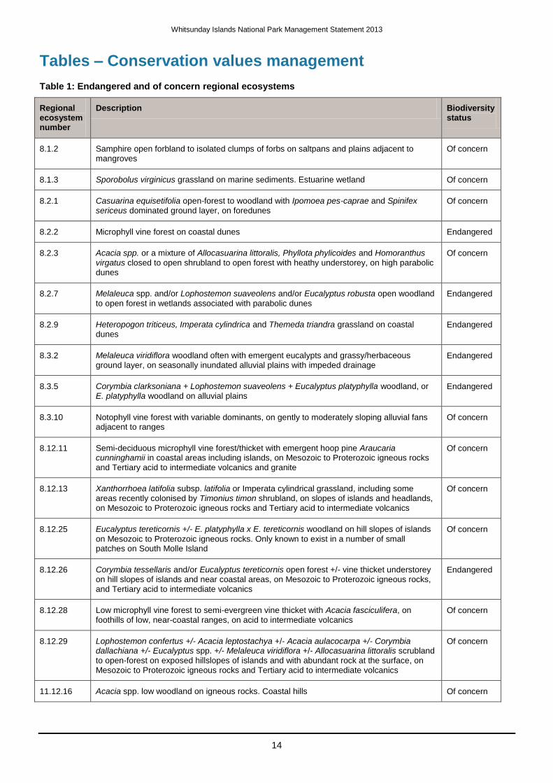
Tables – Conservation values management
Table 1: Endangered and of concern regional ecosystems
Regional ecosystem number
Description Biodiversity status
8.1.2 Samphire open forbland to isolated clumps of forbs on saltpans and plains adjacent to mangroves
Of concern
8.1.3 Sporobolus virginicus grassland on marine sediments. Estuarine wetland Of concern
8.2.1 Casuarina equisetifolia open-forest to woodland with Ipomoea pes-caprae and Spinifex sericeus dominated ground layer, on foredunes
Of concern
8.2.2 Microphyll vine forest on coastal dunes Endangered
8.2.3 Acacia spp. or a mixture of Allocasuarina littoralis, Phyllota phylicoides and Homoranthus virgatus closed to open shrubland to open forest with heathy understorey, on high parabolic dunes
Of concern
8.2.7 Melaleuca spp. and/or Lophostemon suaveolens and/or Eucalyptus robusta open woodland
to open forest in wetlands associated with parabolic dunes Endangered
8.2.9 Heteropogon triticeus, Imperata cylindrica and Themeda triandra grassland on coastal dunes
Endangered
8.3.2 Melaleuca viridiflora woodland often with emergent eucalypts and grassy/herbaceous ground layer, on seasonally inundated alluvial plains with impeded drainage
Endangered
8.3.5 Corymbia clarksoniana + Lophostemon suaveolens + Eucalyptus platyphylla woodland, or E. platyphylla woodland on alluvial plains
Endangered
8.3.10 Notophyll vine forest with variable dominants, on gently to moderately sloping alluvial fans adjacent to ranges
Of concern
8.12.11 Semi-deciduous microphyll vine forest/thicket with emergent hoop pine Araucaria cunninghamii in coastal areas including islands, on Mesozoic to Proterozoic igneous rocks and Tertiary acid to intermediate volcanics and granite
Of concern
8.12.13 Xanthorrhoea latifolia subsp. latifolia or Imperata cylindrical grassland, including some areas recently colonised by Timonius timon shrubland, on slopes of islands and headlands, on Mesozoic to Proterozoic igneous rocks and Tertiary acid to intermediate volcanics
Of concern
8.12.25 Eucalyptus tereticornis +/- E. platyphylla x E. tereticornis woodland on hill slopes of islands
on Mesozoic to Proterozoic igneous rocks. Only known to exist in a number of small patches on South Molle Island
Of concern
8.12.26 Corymbia tessellaris and/or Eucalyptus tereticornis open forest +/- vine thicket understorey on hill slopes of islands and near coastal areas, on Mesozoic to Proterozoic igneous rocks, and Tertiary acid to intermediate volcanics
Endangered
8.12.28 Low microphyll vine forest to semi-evergreen vine thicket with Acacia fasciculifera, on foothills of low, near-coastal ranges, on acid to intermediate volcanics
Of concern
8.12.29 Lophostemon confertus +/- Acacia leptostachya +/- Acacia aulacocarpa +/- Corymbia dallachiana +/- Eucalyptus spp. +/- Melaleuca viridiflora +/- Allocasuarina littoralis scrubland to open-forest on exposed hillslopes of islands and with abundant rock at the surface, on Mesozoic to Proterozoic igneous rocks and Tertiary acid to intermediate volcanics
Of concern
11.12.16 Acacia spp. low woodland on igneous rocks. Coastal hills Of concern
Whitsunday Islands National Park Management Statement 2013
15
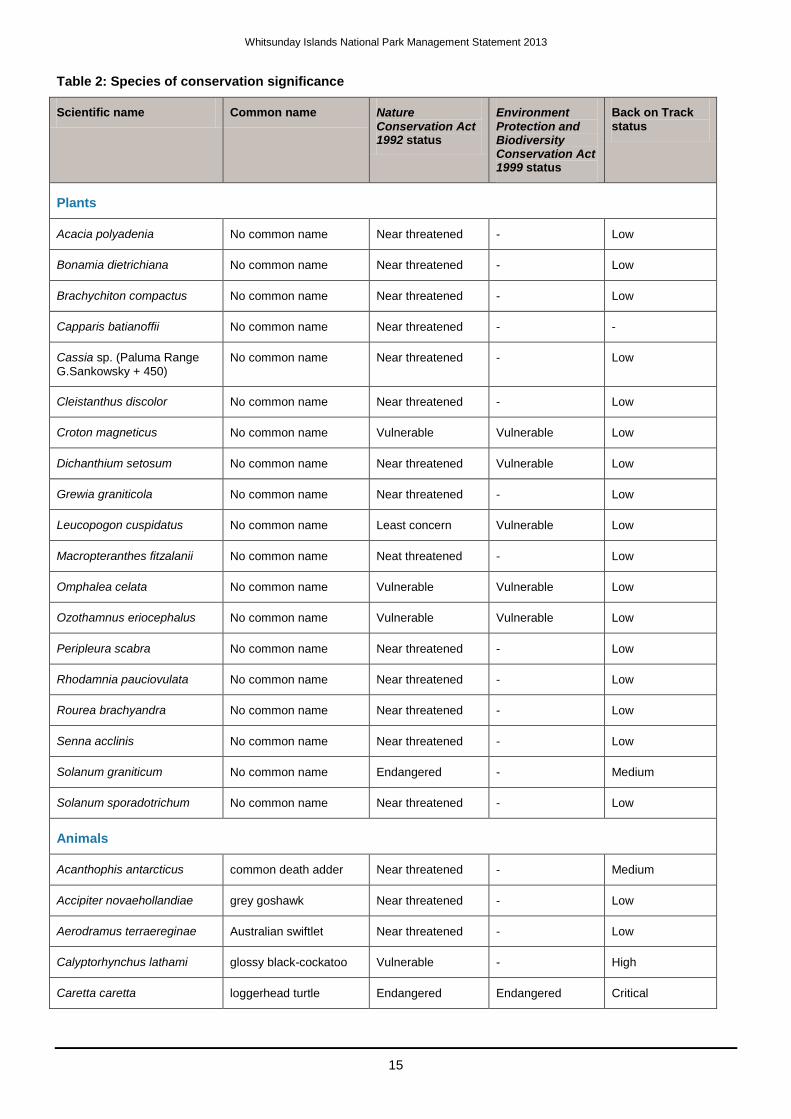
Table 2: Species of conservation significance
Scientific name Common name Nature Conservation Act 1992 status
Environment Protection and Biodiversity Conservation Act 1999 status
Back on Track status
Plants
Acacia polyadenia No common name Near threatened - Low
Bonamia dietrichiana No common name Near threatened - Low
Brachychiton compactus No common name Near threatened - Low
Capparis batianoffii No common name Near threatened - -
Cassia sp. (Paluma Range G.Sankowsky + 450)
No common name Near threatened - Low
Cleistanthus discolor No common name Near threatened - Low
Croton magneticus No common name Vulnerable Vulnerable Low
Dichanthium setosum No common name Near threatened Vulnerable Low
Grewia graniticola No common name Near threatened - Low
Leucopogon cuspidatus No common name Least concern Vulnerable Low
Macropteranthes fitzalanii No common name Neat threatened - Low
Omphalea celata No common name Vulnerable Vulnerable Low
Ozothamnus eriocephalus No common name Vulnerable Vulnerable Low
Peripleura scabra No common name Near threatened - Low
Rhodamnia pauciovulata No common name Near threatened - Low
Rourea brachyandra No common name Near threatened - Low
Senna acclinis No common name Near threatened - Low
Solanum graniticum No common name Endangered - Medium
Solanum sporadotrichum No common name Near threatened - Low
Animals
Acanthophis antarcticus common death adder Near threatened - Medium
Accipiter novaehollandiae grey goshawk Near threatened - Low
Aerodramus terraereginae Australian swiftlet Near threatened - Low
Calyptorhynchus lathami glossy black-cockatoo Vulnerable - High
Caretta caretta loggerhead turtle Endangered Endangered Critical
Whitsunday Islands National Park Management Statement 2013
16
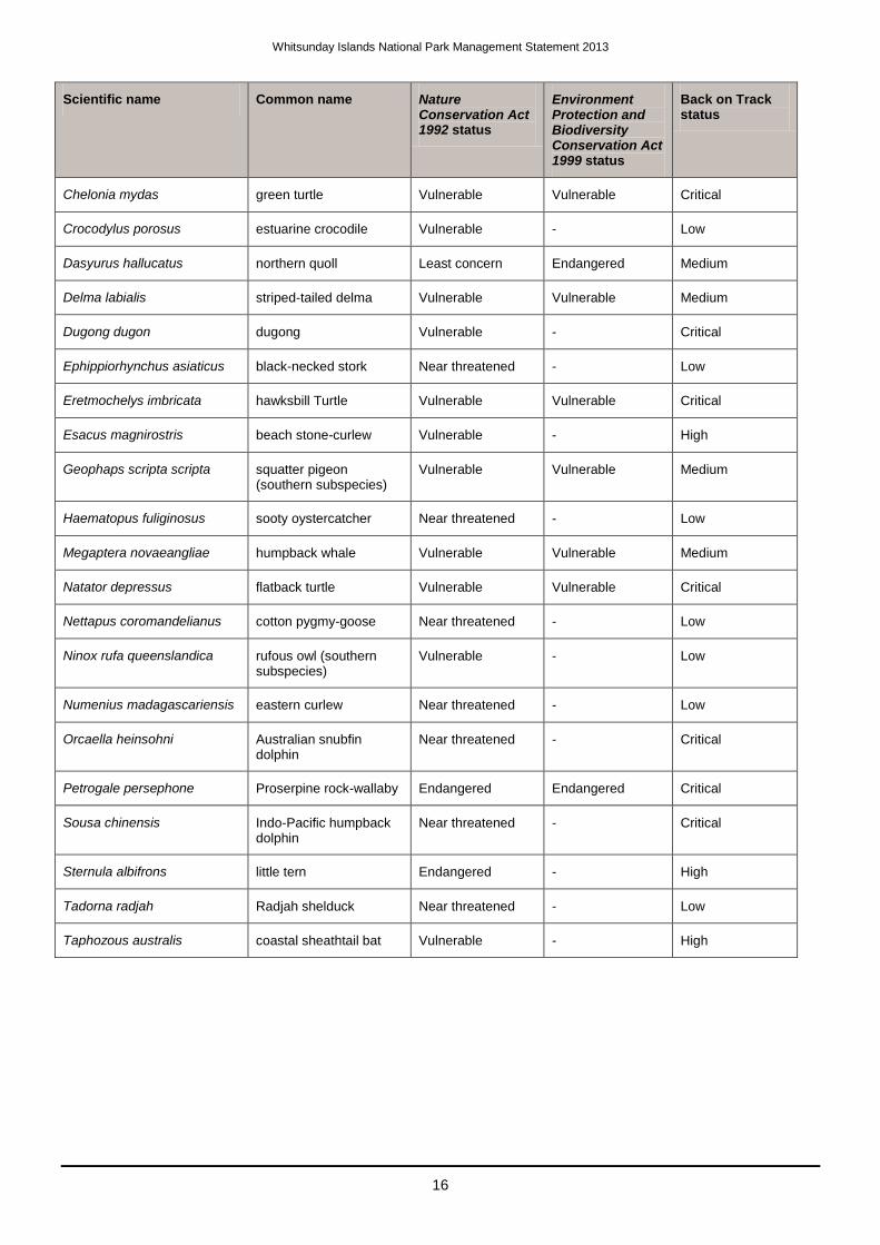
Scientific name Common name Nature Conservation Act 1992 status
Environment Protection and Biodiversity Conservation Act 1999 status
Back on Track status
Chelonia mydas green turtle Vulnerable Vulnerable Critical
Crocodylus porosus estuarine crocodile Vulnerable - Low
Dasyurus hallucatus northern quoll Least concern Endangered Medium
Delma labialis striped-tailed delma Vulnerable Vulnerable Medium
Dugong dugon dugong Vulnerable - Critical
Ephippiorhynchus asiaticus black-necked stork Near threatened - Low
Eretmochelys imbricata hawksbill Turtle Vulnerable Vulnerable Critical
Esacus magnirostris beach stone-curlew Vulnerable - High
Geophaps scripta scripta squatter pigeon (southern subspecies)
Vulnerable Vulnerable Medium
Haematopus fuliginosus sooty oystercatcher Near threatened - Low
Megaptera novaeangliae humpback whale Vulnerable Vulnerable Medium
Natator depressus flatback turtle Vulnerable Vulnerable Critical
Nettapus coromandelianus cotton pygmy-goose Near threatened - Low
Ninox rufa queenslandica rufous owl (southern subspecies)
Vulnerable - Low
Numenius madagascariensis eastern curlew Near threatened - Low
Orcaella heinsohni Australian snubfin dolphin
Near threatened - Critical
Petrogale persephone Proserpine rock-wallaby Endangered Endangered Critical
Sousa chinensis Indo-Pacific humpback dolphin
Near threatened - Critical
Sternula albifrons little tern Endangered - High
Tadorna radjah Radjah shelduck Near threatened - Low
Taphozous australis coastal sheathtail bat Vulnerable - High
Whitsunday Islands National Park Management Statement 2013
17
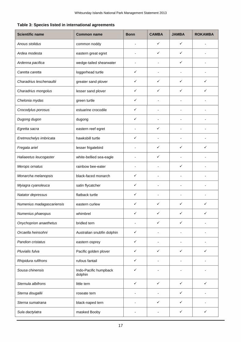
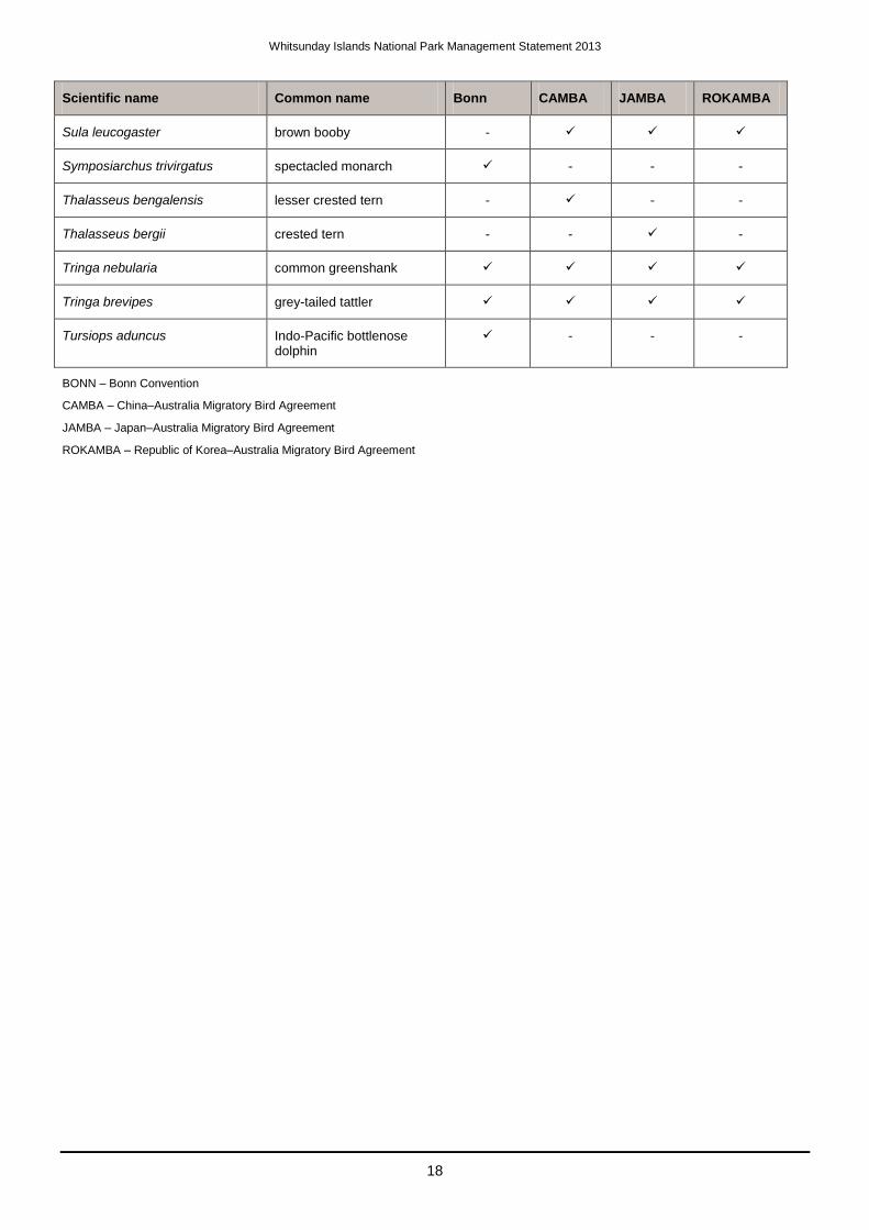
Table 3: Species listed in international agreements
Scientific name Common name Bonn CAMBA JAMBA ROKAMBA
Anous stolidus common noddy - -
Ardea modesta eastern great egret - -
Ardenna pacifica wedge-tailed shearwater - - -
Caretta caretta loggerhead turtle - - -
Charadrius leschenaultii greater sand plover
Charadrius mongolus lesser sand plover
Chelonia mydas green turtle - - -
Crocodylus porosus estuarine crocodile - - -
Dugong dugon dugong - - -
Egretta sacra eastern reef egret - - -
Eretmochelys imbricata hawksbill turtle - - -
Fregata ariel lesser frigatebird -
Haliaeetus leucogaster white-bellied sea-eagle - - -
Merops ornatus rainbow bee-eater - - -
Monarcha melanopsis black-faced monarch - - -
Myiagra cyanoleuca satin flycatcher - - -
Natator depressus flatback turtle - - -
Numenius madagascariensis eastern curlew
Numenius phaeopus whimbrel
Onychoprion anaethetus bridled tern - -
Orcaella heinsohni Australian snubfin dolphin - - -
Pandion cristatus eastern osprey - - -
Pluvialis fulva Pacific golden plover
Rhipidura rufifrons rufous fantail - - -
Sousa chinensis Indo-Pacific humpback dolphin
- - -
Sternula albifrons little tern
Sterna dougallii roseate tern - - -
Sterna sumatrana black-naped tern - -
Sula dactylatra masked Booby - -
Whitsunday Islands National Park Management Statement 2013
18
Scientific name Common name Bonn CAMBA JAMBA ROKAMBA
Sula leucogaster brown booby -
Symposiarchus trivirgatus spectacled monarch - - -
Thalasseus bengalensis lesser crested tern - - -
Thalasseus bergii crested tern - - -
Tringa nebularia common greenshank
Tringa brevipes grey-tailed tattler
Tursiops aduncus Indo-Pacific bottlenose dolphin
- - -
BONN – Bonn Convention
CAMBA – China–Australia Migratory Bird Agreement
JAMBA – Japan–Australia Migratory Bird Agreement
ROKAMBA – Republic of Korea–Australia Migratory Bird Agreement