Embed Size (px)
Citation preview

Whitehead and Associates Environmental Consultants i
Whitehead & Associates Environmental Consultants
197 Main Road Cardiff NSW 2285 Australia Telephone +61 2 4954 4996 Facsimile +61 2 4954 4996 Email [email protected]
Colac Otway Shire Council
Domestic Wastewater Management Plan
Technical Document
FINAL
November 2015
Prepared for: Colac Otway Shire Council
Prepared by: Jasmin Kable, Zoe Rogers and Mark Saunders Whitehead & Associates Environmental Consultants Pty Ltd 197 Main Road CARDIFF NSW 2285
Telephone: Fax: Email:
02 4954 4996 02 4954 4996 [email protected]
Whitehead and Associates Environmental Consultants ii
Document Control Sheet Document and Project Details
Document Title: Colac Otway Shire Council Domestic Wastewater Management Plan
Author: Jasmin Kable, Zoe Rogers and Mark Saunders
Project Manager: Mark Saunders
Date of Issue: 04/11/15
Job Reference: 1307 COS FINAL DWMP_Technical Document_008.docx
Synopsis: This document has been developed to accompany and direct the Operational Plan (2015) to assist with detailed assessment of properties/parcels within the Shire to accommodate wastewater on-site. Together, both documents form the Domestic Wastewater Management Plan (DWMP). It provides additional detail and guidance on the relevant background documents (codes, policies, plans, legislation, regulations and standards) and the various constraints which impact upon or, is impacted upon, by domestic wastewater management (DWM) in the Shire.
Client Details
Client: Colac Otway Shire Council
Primary Contact: Doug McNeill (Manager, Planning, Building and Health) Telephone (03) 5232 9562
Document Distribution
Version Number
Date Status DISTRIBUTION – NUMBER OF COPIES (p – print copy; e – electronic copy)
Client Other Other 001 30/01/15 DRAFT 1e - - 003 22/04/15 Revised DRAFT 1e 004 30/04/15 Revised DRAFT 1e 005 10/06/15 Revised DRAFT 1e 006 02/07/15 FINAL 1e 007 14/07/15 FINAL 1e 008 04/11/15 FINAL 1e, 3p
Document Verification
Checked by:
Issued by:
Mark Saunders Jasmin Kable
Whitehead and Associates Environmental Consultants i
Disclaimer The information contained in this report is based on independent research undertaken by Whitehead & Associates Environmental Consultants Pty Ltd (W&A). To our knowledge, it does not contain any false, misleading or incomplete information. Recommendations are based on an appraisal of site conditions subject to the limited scope and resources available for this project, and follow relevant industry standards. The work performed by W&A included a limited system audit and site and soil investigation in addition to a desktop review, and the conclusions made in this report are based on the information gained and the assumptions as outlined. Under no circumstances, can it be considered that these results represent the actual conditions throughout the entire Shire due to the regional scale of this study.
Copyright Note © Whitehead & Associates Environmental Consultants Pty Ltd, 2015
This report and accompanying plans were prepared for the exclusive use of Colac Otway Shire Council (the “Client”). No extract of text of this document may be reproduced, stored or transmitted in any form without the prior consent of Whitehead & Associates. Plans accompanying this document may not be reproduced, stored or transmitted in any form unless this copyright note is included.
Document Certification This Domestic Wastewater Management Plan has been prepared following the standards and guidelines set out in the following documents, where applicable:
• EPA Victoria (2013) Code of Practice – Onsite Wastewater Management;
• Department of Sustainability and Environment (2012) Planning permit applications in open, potable water supply catchment areas;
• EPA Victoria (2003) State Environmental Protection Policy: Waters of Victoria;
• EPA Victoria (2002) State Environmental Protection Policy: Groundwaters of Victoria;
• Municipal Association of Victoria (2014) Victoria Land Capability Assessment Framework, 2nd Ed; and
• AS/NZS 1547:2012 On-site Domestic Wastewater Management (Standards Australia/ Standards New Zealand, 2012).
To our knowledge, it does not contain any false, misleading or incomplete information. Recommendations are based on an honest appraisal of the sites’ opportunities and constraints, subject to the limited scope and resources available for this project.
Supporting Author Supporting technical contribution for this document was provided by Dr. Robert Van de Graaff (van de Graaff and Associates). Dr. Van de Graaff undertook detailed (field) soil investigation and has provided primary soil data and interpretation which has been utilised in the development of the methodology outlined in this document.
Whitehead and Associates Environmental Consultants ii
Table of Contents Acronyms ...................................................................................................... 1
1 Introduction .......................................................................................... 2
2 Council Policies and Plans .................................................................. 2
2.1 Council Plan 2013 – 2017 .................................................................................. 2
2.2 Municipal Public Health and Wellbeing Plan 2013 – 2017 ............................ 2
2.3 Colac Otway Planning Scheme ........................................................................ 3
2.4 Rural Living Strategy 2011 ................................................................................ 3
2.5 Council Budget ................................................................................................... 3
3 Legislation and Regulation.................................................................. 4
3.1 Legislation ........................................................................................................... 4
3.1.1 Local Government Act 1989 ............................................................................... 4
3.1.2 Environment Protection Act 1970 ....................................................................... 4
3.1.3 Water Act 1989 ................................................................................................... 5
3.1.4 Planning and Environment Act 1987 .................................................................. 5
3.1.5 Public Health and Wellbeing Act 2008 ................................................................ 6
3.1.6 State Environmental Protection Policy Waters of Victoria................................... 6
3.1.7 State Environmental Protection Policy Groundwaters of Victoria ....................... 7
3.1.8 Victorian Building Regulations 2006 ................................................................... 7
3.2 Regulatory Authorities....................................................................................... 7
3.2.1 Council (Colac Otway Shire Council) .................................................................. 7
3.2.2 Environment Protection Authority Victoria (EPA) ................................................ 8
3.2.3 Plumbing Industry Commission (PIC) ................................................................. 8
3.2.4 Municipal Association of Victoria (MAV) ............................................................. 9
3.2.5 Water Corporations ............................................................................................ 9
3.2.6 Department of Environment, Land, Water and Planning .................................... 9
3.2.7 Catchment Management Authority ..................................................................... 9
3.3 Administrative Authorities ..............................................................................10
3.4 Standards and Guidelines ...............................................................................10
3.4.1 EPA Code of Practice – On-site Wastewater Management .............................. 10
3.4.2 Model Land Capability Assessment (2014) ...................................................... 10
3.4.3 Land Capability Assessment (2003) ................................................................. 10
3.4.4 AS/NZS 1547:2012 On-site Domestic Wastewater Management..................... 10
3.4.5 AS/NZS 3500:2003 Plumbing and Drainage .................................................... 11
4 Overview of DWM in Colac Otway Shire ........................................... 12
Whitehead and Associates Environmental Consultants iii
4.1 The Local Environment ...................................................................................12
4.1.1 Declared Water Supply Catchments ................................................................. 12
4.1.2 Soils .................................................................................................................. 13
4.1.3 Climate ............................................................................................................. 13
4.1.4 Bushfire ............................................................................................................ 13
4.2 DWM Systems and Trends in Colac Otway Shire ........................................13
4.3 DWM System Inspections in Drinking Water Catchments .........................16
4.3.1 Wastewater Treatment Systems ....................................................................... 16
4.3.2 Effluent Disposal Systems ................................................................................ 17
5 Preliminary Data Collection (Stage 1) ............................................... 18
5.1 Data Acquisition ...............................................................................................18
5.2 Property (Parcel) Characterisation ................................................................18
6 GIS Data Analysis (Stage 2)............................................................... 20
6.1 Domestic Wastewater Management Constraints .........................................20
6.2 DWM Constraint Mapping ...............................................................................20
6.2.1 Constraint Classification Framework ................................................................ 20
6.2.2 Climate ............................................................................................................. 21
6.2.3 Useable Lot Area .............................................................................................. 29
6.2.3.1 Proximity to Surface Waters....................................................................... 30
6.2.3.2 Proximity to Groundwater Bores ................................................................ 33
6.2.3.3 Land Subject to Inundation ........................................................................ 34
6.2.3.4 Useable Lot Area Analysis ......................................................................... 34
6.2.4 Current Planning Scheme Zone - Minimum Lot Size Compliance .................... 38
6.2.5 Slope ................................................................................................................ 42
6.2.6 Soil Suitability ................................................................................................... 46
6.3 Sensitivity Overlay ...........................................................................................54
6.3.1 Landslip Hazard ................................................................................................ 54
6.3.2 Groundwater Depth .......................................................................................... 54
6.3.3 Vegetation ........................................................................................................ 56
6.4 Risk Assessment Summary ............................................................................56
7 Land Application System Sizing Tables (Water Balance) ............... 57
7.1 Overview ............................................................................................................57
7.2 Water Balance Methodology ...........................................................................57
7.3 Water Balance Inputs .......................................................................................58
7.3.1 Daily Wastewater Load ..................................................................................... 58
7.3.2 Climate Data ..................................................................................................... 58
Whitehead and Associates Environmental Consultants iv
7.3.3 Runoff Factor .................................................................................................... 58
7.3.4 Soil Type and Design Loading Rate or Design Irrigation Rate (DLR or DIR) .... 59
7.4 Implications for High Rainfall Areas ..............................................................59
7.5 Footprint Area of Land Application Systems ...............................................60
8 Sub-catchment Analysis .................................................................... 61
9 Glossary of Terms .............................................................................. 64
10 References.......................................................................................... 65
Appendix A Informative Maps....................................................................... 67 Appendix B Locality Reports ........................................................................ 76 A. Alvie Locality Report.......................................................................... 77
B. Barham River Catchment (Apollo Bay) Locality Report .................. 84
C. Barongarook Locality Report ............................................................ 91
D. Barwon Downs Locality Report......................................................... 98
E. Beeac Locality Report...................................................................... 106
F. Beech Forest Locality Report .......................................................... 113
G. Carlisle River Locality Report ......................................................... 121
H. Coragulac Locality Report ............................................................... 129
I. Cororooke Locality Report .............................................................. 135
J. Forrest Locality Report .................................................................... 142
K. Gellibrand Locality Report............................................................... 149
L. Kawarren Locality Report ................................................................ 158
M. Kennett River Locality Report ......................................................... 166
N. Lavers Hill Locality Report .............................................................. 173
O. Wye River and Separation Creek Locality Report .......................... 180
Appendix C ................................................................................................ 187
Acceptable Monthly Climate Data ............................................................ 187
Colac Otway Shire Council Domestic Wastewater Management Plan - Technical Document
Whitehead and Associates Environmental Consultants 0
List of Figures Figure 1: 70th Percentile Rainfall Distribution – Shire ............................................. 25 Figure 2: Total Number of Wet Months Distribution – Shire .................................... 26 Figure 3: Climate Zones Distribution – Shire ............................................................ 27 Figure 4: Total Number of Consecutive Wet Months Distribution – Shire .............. 28 Figure 5: Corangamite CMA Declared Water Supply Catchments (DEPI, 2012) .... 32 Figure 6: DWM Constraint Analysis - Useable Lot Area – Shire .............................. 37 Figure 7: Minimum Lot Size Zoning Requirements – Shire ..................................... 41 Figure 8: Surface Elevation Digital Elevation Model – Shire ................................... 44 Figure 9: DWM Constraint Analysis - Average Lot Slope – Shire ........................... 45 Figure 10: Surface Geology – Shire ........................................................................... 47 Figure 11: Soil Landform Units – Shire ...................................................................... 48 Figure 12: DWM Constraint Analysis - Soil Suitability – Shire ................................ 53 Figure 13: Delineated Sub-catchments within DWSCs ............................................ 62 Figure 14: Sub-catchment and Associated Sensitivity Analysis within DWSCs.... 63
List of Tables Table 1: DWM System Types ...................................................................................... 15 Table 2: Land Application Methods ........................................................................... 16 Table 3: Rationale for DWM Constraint Ratings ....................................................... 21 Table 4: Climate Zones Constraint Map Summary ................................................... 24 Table 5: Useable Lot Area Constraint Map Summary............................................... 36 Table 6: Current Planning Scheme Zone - Minimum Lot Size Compliance ............ 40 Table 7: Average Property/ Parcel Slope Constraint Map Summary ....................... 43 Table 8: Soil Suitability Constraint Classification Criteria ....................................... 51 Table 9: Soil Suitability Constraint Map Summary ................................................... 52 Table 10: Design Wastewater Loads for Water Balance Modelling ......................... 58
Colac Otway Shire Council Domestic Wastewater Management Plan - Technical Document
Whitehead and Associates Environmental Consultants 1
Acronyms AEP Annual Exceedance Probability
ARI Annual Recurrence Interval
AHD Australian Height Datum
AWTS Aerated Wastewater Treatment System
CMA Catchment Management Authority
CA Certificate of Approval
COS Colac Otway Shire Council
DEM Digital Elevation Model
DEPI Department of Environment and Primary Industries (now known as DELWP)
DELWP Department of Environment, Land, Water and Planning
DIR Design Irrigation Rate
DLR Design Loading Rate
DSE Department of Sustainability and the Environment (former)
DSM Decentralised Sewage Model
DWM Domestic Wastewater Management
DWMP Domestic Wastewater Management Plan
DWSC Declared Water Supply Catchment
EPA Environment Protection Authority
GIS Geographic Information System
GMAs Groundwater Management Area
HPO Health Protection Officer
LAA Land Application Area
LCA Land Capability Assessment
LGA Local Government Area
LPED Low-Pressure Effluent Distribution System
LRA Land Resource Assessment
MAV Municipal Association of Victoria
PIC Plumbing Industry Commission
SEPP State Environment Protection Policy
SILO Scientific Information for Land Owners
VCAT Victorian Civil and Administrative Tribunal
VVG Visualising Victoria’s Groundwater (Project)
WC Water Corporation(s)
WMIS Water Measurement Information System
WSPAs Water Supply Protection Area(s)

Colac Otway Shire Council Domestic Wastewater Management Plan - Technical Document
Whitehead and Associates Environmental Consultants 2
1 Introduction This document forms the Domestic Wastewater Management Plan (DWMP) together with the Operational Plan (2015), and has been prepared in order to assist with the detailed assessment of unsewered (developed and undeveloped) properties/parcels in the Colac Otway Shire municipal area (COS or “the Shire”). It provides additional detail and guidance on relevant background documents (codes, policies, plans, legislation, regulations and standards), an overview of on-site domestic wastewater management (DWM) within COS, the various constraints which impact upon or are impacted by on-site DWM, system sizing tables and DWM sensitivity analysis for locality and town/settlement prioritisation. The document also provides guidance for sustainable development in unsewered areas as detailed in the individual Locality Reports.
2 Council Policies and Plans The DWMP has been developed to complement other Council policies and plans through the actions identified in the Operational Plan. The following is a brief outline of the various Council plans which have been included in the development of this DWMP.
2.1 Council Plan 2013 – 2017 Council’s Vision Statement applies to all Council policies including the DWMP. The Vision of COS is:
“A sustainable community with a vibrant future” (COS, 2013)
The Vision and Mission statements will be achieved by implementing the five values of Council, respect, integrity, goodwill, honesty and trust; with the Council Plan structured around four key themes:
1. Good Governance – Ensure transparency of governance practices, the capability of our organisation and effective resource management;
2. A Planned Future – Facilitate the growth, liveability and development of the Shire and encourage innovation and efficiency in the local economy;
3. A Place to Live and Grow – Improve access to buildings, spaces, services and education to support and enable quality of life; and
4. A Healthy Community and Environment – Respect cultural differences, support a diverse range of healthy and creative activities, foster community safety and promote environmental sustainability.
The Council Plan outlines outcomes which must be achieved in line with the key values; these outcomes will be aligned with the DWMP.
2.2 Municipal Public Health and Wellbeing Plan 2013 – 2017 The Colac Otway Shire Municipal Public Health and Wellbeing Plan aims to enhance the health and wellbeing of the residents of COS. The main priorities in this plan are categorised into the following themes: embed key health and wellbeing enablers, plan for an ageing population, reduce significant levels of disadvantage in early years, increase levels of physical activity, protection through public and environmental health, support healthy eating and food security, support mental health and connectedness, prevention of violence against women and children, support healthy behaviours, and reduce harm from alcohol, tobacco and other drugs.
Colac Otway Shire Council Domestic Wastewater Management Plan - Technical Document
Whitehead and Associates Environmental Consultants 3
2.3 Colac Otway Planning Scheme The Colac Otway Planning Scheme, approved under the Planning and Environment Act 1987, sets out planning policies for the municipality, and contains information about zones, overlays and other provisions which affect how land can be used and developed in COS. It identifies triggers for planning permit applications, and outlines application requirements and decision guidelines for the use, subdivision and development of land in the different zones.
On land where DWM is required, a planning application may need supporting information such as a Land Capability Assessment (LCA) to show that the property/parcel can accommodate a DWM system. Almost all applications within DWSCs must be referred to the relevant Water Corporation (WC). If the WC objects to the application, it must be refused by Council.
Under Section 173 of the Planning and Environment Act 1987, Council can enter into a legal agreement with the owner of land in its municipality, with the agreement binding the owner to the covenants specified in the agreement. Such S173 agreements can be used to prohibit, restrict or regulate the use of land, or can relate to conditions subject to which the land may be used or developed for specified purposes. A Planning Permit condition can require the owner to enter such a legal agreement, which is subsequently registered on the title of the property. Such a legal agreement may be required by Council or the WC’s when planning applications are located within a DWSCs. In such cases, the Section 173 agreements often contain maintenance requirements for DWM systems, which on the sale of a property, transfer to an incoming owner.
2.4 Rural Living Strategy 2011 Council adopted a Rural Living Strategy in 2011 which considered the development potential of smaller towns/settlements in the municipality. The towns of Forrest, Birregurra, Beeac, Alvie, Cororooke and Coragulac were all identified as having moderate growth potential. Gellibrand, Lavers Hill and Beech Forest had “deferred” growth potential due to potential bushfire and water catchment constraints.
2.5 Council Budget The Council Budget sets out finances for all Council projects and their management. To implement the DWMP, the Budget will need to provide scope for the management of the audit and inspection program required as part of the DWMP. The Budget currently allocates fees and charges for Septic Tank Permits. These fees and charges cover resources required to assess, discuss, permit the installation, inspect, and approve the use of new and modified systems. Council will need to consider options for implementing appropriate ongoing fees and charges for all unsewered properties to provide resources to undertake Actions and programs within the Operational Plan.
Colac Otway Shire Council Domestic Wastewater Management Plan - Technical Document
Whitehead and Associates Environmental Consultants 4
3 Legislation and Regulation 3.1 Legislation 3.1.1 Local Government Act 1989 The Local Government Act 1989 outlines the provisions under which Council operates and empowers Councils to have local laws and regulations for DWM. The Local Government Act 1989 empowers Council to enact local laws and set special charges for Council activities. Council can use these powers to develop local regulations for wastewater management, as long as these regulations are consistent with state policy and legislation and to raise revenue for its wastewater management programs.
3.1.2 Environment Protection Act 1970 The Environment Protection Act 1970 is used to regulate DWM systems.
Sections 53J – 53O of the Act deal with the requirements for permits and conditions of approval for the installation of DWM systems. Specifically the Act outlines the following requirements:
• A permit must be issued for the construction, installation or alteration of a septic tank system;
• An application for a permit is made by an owner to the Council and must be in accordance with the manner approved by Council;
• The application must be accompanied by plans and specifications of the proposed septic tank system. Specifications of the proposed treatment method are also to be provided;
• A person must comply with a permit and any conditions to which it is subject;
• The system must not be used until Council has issued a certificate approving the systems use;
• The occupier of premises on which a septic tank (DWM) system is installed is to maintain the system in accordance with the conditions of the permit for the system; and
• A person who applied for a permit, or the occupier of premises on which a DWM system is installed is liable to fines issued by Council if non-compliance with an installation permit is identified by Council.
Section 53 also states that the Council must lodge with the Environment Protection Authority (EPA) at the end of each financial year a report containing details of the following:
• Details of the number of permits issued for septic tank systems;
• The number of septic tank systems disconnected; and
• The number of septic tank systems which have been in use within the municipality during the financial year.
Part I Section 1B – 1L of the Act also requires that any application must have regard to the principles of environment protection, which include:
• Principle of integration of economic, social and environmental considerations;
• The precautionary principle;
• Principle of intergenerational equity;
Colac Otway Shire Council Domestic Wastewater Management Plan - Technical Document
Whitehead and Associates Environmental Consultants 5
• Principle of conservation of biological diversity and ecological integrity;
• Principle of improved valuation, pricing and incentive mechanisms;
• Principle of shared responsibility;
• Principle of product stewardship;
• Principle of wastes hierarchy;
• Principle of integrated environmental management;
• Principle of enforcement; and
• Principle of accountability.
It is also important to note the principles state that:
• Measures should be cost effective and proportionate to the risk;
• An assessment of risk-weighted consequences is undertaken;
• Persons who generate pollution and waste should bear the cost of containing, avoiding and abatement; and
• Managing the impact is a shared responsibility.
Part III Section 16 of the Act allows for the preparation of State Environment Protection Policy (SEPP); the two relevant SEPPs for DWM are SEPP Waters of Victoria and SEPP Groundwaters of Victoria.
3.1.3 Water Act 1989 Section 183 of the Water Act 1989, provides a Water Corporation (WC) with the power to inspect and monitor existing septic tank systems within their sewerage district, and if the system does not comply with the Environment Protection Act 1970 and the Public Health and Wellbeing Act 2008, then the WC can require the owner to connect to the sewer where it is available under Section 147 of the Act.
3.1.4 Planning and Environment Act 1987 The Planning and Environment Act 1987 is ‘enabling’ legislation, with more detailed planning matters dealt with by subordinate instruments under the Act, such as the Victorian Planning Provisions, planning schemes, regulations and Ministerial Directions. Key components of the planning framework established by the Act include:
• The system of planning schemes that sets out how the land may be used and developed;
• The VPP, which provide the template for the construction and layout of planning schemes;
• The procedures for preparing and amending the VPP and planning schemes;
• The procedures for obtaining planning permits under planning schemes; and
• The procedures for settling disputes, enforcing compliance with planning schemes and other administrative procedures.
Planning schemes set out how land may be used and developed, including the requirements for obtaining planning permits. Where domestic wastewater is required, a planning permit may
Colac Otway Shire Council Domestic Wastewater Management Plan - Technical Document
Whitehead and Associates Environmental Consultants 6
need supporting information such as a Land Capability Assessment (LCA) to show that the development can accommodate a DWM system.
All applications within drinking water catchments must be referred to the applicable WC. If the referral authority objects to the application it must be refused by Council.
As noted in Section 2.3 above, Under Section 173 of the Planning and Environment Act 1987, Council can require the preparation of a legal agreement. These agreements are often requested by Council or the Water Authorities when planning applications are located within a Declared Water Supply Catchment (DWSC). The Section 173 agreements often contain maintenance requirements for DWM systems, which on the sale of a property transfer to an incoming owner.
3.1.5 Public Health and Wellbeing Act 2008 The Public Health & Wellbeing Act 2008 lists types of nuisances which may be dangerous to health or offensive; these nuisances include those arising from water or any matter which is dangerous to health or offensive, including wastewater. Council has a duty under this Act to remedy as far as is reasonably possible all nuisances arising in the Shire, and it is an offence to cause or allow a nuisance to occur. Under this Act, Council must investigate all complaints relating to a nuisance or the illegal management of domestic wastewater and take action to rectify the nuisance where necessary. This can include a direction from Council to the owner of a DWM system to cease to operate and/or upgrade their DWM system, by issuing a Prohibition Notice and/or an Improvement Notice to the owner.
3.1.6 State Environmental Protection Policy Waters of Victoria The SEPP Waters of Victoria provides a regulatory framework for the protection and management of surface water environments in Victoria. This SEPP has three main policy sections; beneficial uses, environmental quality objectives and attainment program. The SEPP aims to protect surface water for a number of reasons, including but not limited to, human consumption after appropriate treatment, human consumption of aquatic fauna, recreation, agriculture and aquaculture.
The discharge of domestic wastewater in a manner which could enter surface waters has the potential to impact on the use of the water for any of the beneficial uses described above. As such, the discharge of domestic wastewater must be in accordance with buffer distances outlined in the current EPA Code of Practice so as to minimise any potential negative impacts on surface waters.
Environmental quality objectives are used to indicate and measure if the beneficial uses are being protected. The use of water quality and biological indicators, flow measurement, sediment quality and habitat indicators can be used in accordance with the policy to determine if the surface waters have been affected. The SEPP indicates the roles and responsibilities, and details actions and tools, for the protection of surface waters in Victoria.
This policy is used for assessing effluent disposal areas and in preparing LCAs. Clause 32 (b) allows EPA guidance and the current EPA Code of Practice to be mandatory. The policy requires regulatory authorities to assess the suitability of land with reference to EPA Publication 746.1 – Land Capability Assessment for On-site Wastewater Management and to ensure that permits comply with EPA Code of Practice and all EPA publications and bulletins.
Colac Otway Shire Council Domestic Wastewater Management Plan - Technical Document
Whitehead and Associates Environmental Consultants 7
3.1.7 State Environmental Protection Policy Groundwaters of Victoria The SEPP Groundwaters of Victoria provides a regulatory framework for the protection and management of groundwater environments in Victoria. The reuse of domestic wastewater on-site can impact on groundwater via deep drainage. Careful design of systems can ensure impacts are minimised so that groundwater resources are not affected. The SEPP indicates the roles and responsibilities, and details actions and tools, for the protection of ground waters in Victoria. This policy requires effluent disposal to be carried out so as to protect groundwater. The preparation of a LCA must consider the potential impact, if any, on local and regional groundwater resources.
3.1.8 Victorian Building Regulations 2006 Under Part 8 of the Regulations (Building work in special areas), Clause 801 (Septic tank systems) applies as follows:
(1) The report and consent of the relevant council must be obtained to an application for a building permit that requires:
(a) the installation or alteration of a septic tank system; or
(b) the construction of a building over an existing septic tank system.
(2) The report and consent of the relevant council need not be obtained to an application for a building permit referred to in sub-regulation (1) if a permit for the construction, installation or alteration of the septic tank system that is relevant to the application has been issued under Part IXB of the Environment Protection Act 1970.
3.2 Regulatory Authorities 3.2.1 Council (Colac Otway Shire Council) Council is responsible for issuing permits for new DWM systems under the Environment Protection Act 1970. Council is also responsible for the management of all DWM systems within the Shire; this includes the inspection of existing systems and ensuring compliance with Council and EPA requirements. The legal requirements of Council include:
• Council must issue a permit to install/alter before a DWM system can be installed;
• Application for a permit to install/alter must be completed by the owner/builder/installer and submitted to Council for assessment;
• A Council officer assesses application and plans and conducts site inspections. Further information may be requested from applicant;
• Permit to install issued with approved plan and conditions;
• System must comply with permit conditions and relevant EPA Certificate(s) of Approval;
• System is inspected by a Council officer during installation; and
• Council must issue a permit of use before the system can be used.
In addition, Council can enforce upgrades of systems which are failing and potentially causing human or environmental health impact. This is discussed further in the Operational Plan of the DWMP.
Colac Otway Shire Council Domestic Wastewater Management Plan - Technical Document
Whitehead and Associates Environmental Consultants 8
3.2.2 Environment Protection Authority Victoria (EPA) EPA Victoria regulates what types of DWM systems are approved for use. Manufacturers must seek a Certificate of Approval (CA) of their system prior to releasing it on the market in Victoria. The EPA has a full list of all systems approved for use. The EPA has recently identified the need to reform its administration of the on-site wastewater management program. It intends to remove the requirement for individual treatment systems to hold an EPA Certificate of Approval and instead, will only approve types of systems (e.g. Aerated Wastewater Management Systems) rather than manufactured models as required by the Environment Protection Act 1970. From 1st July 2015, all existing CAs will be transformed to "interim certificates of compliance" valid until the reform is completed (target date 1st January 2016).
The EPA has developed policies and Codes of Practice to regulate the use of DWM systems. These policies and codes include:
• SEPP Waters of Victoria;
• SEPP Groundwaters of Victoria;
• EPA 891.3 Code of Practice – Onsite Wastewater Management, 2013;
• EPA 746.1 Land Capability Assessment – Onsite Wastewater Management, 2003; and
• EPA 760 Guidelines for Aerated Onsite Wastewater Treatment Systems.
The EPA is responsible for the following activities related to wastewater management:
• Issue CAs for each DWM system type;
• Approval of commercial wastewater management systems with wastewater loading in the range of 5,000-100,000L/day (EPA Works Approval, as discussed in the Operational Plan);
• Licencing commercial wastewater management systems with wastewater loading above 100,000L/day, and systems which discharge effluent to surface waters (as discussed in the Operational Plan);
• Inspection of licenced commercial wastewater management systems and review of Annual Performance Statements for licenced commercial wastewater management systems;
• Compliance and enforcement activities for commercial wastewater systems;
• Developing policies and Codes of Practice;
• Provision of technical advice to Councils, owners and installers; and
• Possible referral authority for subdivisions.
3.2.3 Plumbing Industry Commission (PIC) • Licenses all plumbers, drainers and septic tank installers across Victoria; and
• Regulates the installation of all plumbing works including internal plumbing works on septic tank systems.
Colac Otway Shire Council Domestic Wastewater Management Plan - Technical Document
Whitehead and Associates Environmental Consultants 9
3.2.4 Municipal Association of Victoria (MAV) MAV has developed a model LCA report and procedures for undertaking a LCA, to assist land capability assessors and regulators. This has been developed in accordance with EPA Codes and AS/NZS 1547:2012.
3.2.5 Water Corporations Water and sewerage services within COS are provided by Barwon Water, with water also supplied by Southern Rural Water to the north of the Shire and by Wannon Water to the Carlisle River town. This DWMP covers areas where reticulated sewer service is not provided by Barwon Water and, hence, are unsewered.
The WCs have interest in protecting the DWSCs which are susceptible to impact from DWM systems. Both Barwon Water and Wannon Water are statutory referral authorities under the Planning and Environment Act 1987 for planning applications in the DWSCs within the southern region of the Shire. Where specified development or subdivision is proposed within a DWSC, the proposal must be referred to the relevant WC for assessment prior to Council issuing a planning permit. There are two types of referral authorities – a determining referral authority, which has the power to require a permit application to be refused or for certain conditions to be included in a permit, and a recommending referral authority, which can only comment on an application. Responsible authorities must consider the comments made by a recommending authority, but are not obliged to refuse the application or to include any conditions required by the authority. However, a recommending referral authority is able to seek a review at VCAT if it objects or it requests conditions that are not included by the responsible authority in the permit.
Clause 66 of the COS Planning Scheme identifies which authorities are determining authorities and which are recommending authorities. The schedule to Clause 66.04 of the COS Planning Scheme lists Barwon Water and Wannon Water (Water Authorities) as determining referral authorities in the DWSC areas along with Southern Rural Water within the Warrion Water Supply Protection Area. Corangamite CMA is the only recommending authority listed.
Where existing DWM systems are located in an area that has sewer available, the WC can require the property be connected to sewer if the system is found to be causing a health or environmental risk.
3.2.6 Department of Environment, Land, Water and Planning The Department of Environment, Land, Water and Planning (DELWP) (formerly known as the Department of Environment and Primary Industries) is responsible for the management of water resources, climate change, bushfires, public land, forests and ecosystems in Victoria. The DELWP may be consulted by Council for specialist advice where a DWM system may impact on land or water resources.
3.2.7 Catchment Management Authority COS falls within the Corangamite Catchment Management Authority (CMA) and has a large catchment area for a number of different water resources. Where DWM systems exist within sensitive catchments, close examination of a system, its operation and performance must be undertaken to ensure the protection of the asset. The CMA has policies and management tools to assist with the management of the waterways. The role of the CMA is:
• To ensure the sustainable development of natural resource based industries;
• To maintain and where possible, improve the quality of land and water resources;

Colac Otway Shire Council Domestic Wastewater Management Plan - Technical Document
Whitehead and Associates Environmental Consultants 10
• To conserve natural and cultural heritage;
• To involve the community in decisions relating to natural resource management within their region;
• To advise on matters relating to catchment management and land protection and the condition of land and water resources in the region; and
• To promote community awareness and understanding of the importance of land and water resources, their suitable use, conservation and rehabilitation.
3.3 Administrative Authorities The Victorian Civil and Administrative Tribunal (VCAT) is a tribunal at which civil disputes, administrative decisions and appeals can be heard before a Judge or Tribunal Member. It provides a dispute resolution service for both government and individuals within Victoria.
In recent cases VCAT has questioned the quality of LCAs for DWM, particularly where a site is located within a DWSC. VCAT has also questioned the rigour of Council evaluation of these LCAs, and how the minimum development guideline of 1 dwelling per 40 hectares should be applied in the DWSC.
3.4 Standards and Guidelines 3.4.1 EPA Code of Practice – On-site Wastewater Management The EPA Code of Practice On-site Wastewater Management Publication 891.3 (EPA, 2013) outlines the measures which are required to sustainably manage household wastewater so as to minimise public health and environmental impacts. This Code is not limited to DWM systems; it also applies to systems at other premises including small scale commercial systems. The Code outlines planning requirements, system selection and system maintenance following installation.
3.4.2 Model Land Capability Assessment (2014) The Municipal Association of Victoria Model Land Capability Assessment (2014) was revised to reflect the requirements of the current EPA Code of Practice and also provides further details on in-soil effluent assimilation processes and their influence on system design.
3.4.3 Land Capability Assessment (2003) The Land Capability Assessment On-site Wastewater Management Publication 746.1 (2003) outlines the process to be undertaken when assessing a site for its suitability for DWM. An LCA must be conducted by a suitably qualified consultant experienced in on-site domestic wastewater land capability. Land capability assessors should follow the conservative and ‘best practice’ Model LCA Report (MAV, 2014). Council’s role is to assess the land capability and risk assessment report, flow rates, land application calculations and design; it is not part of Council’s role to undertake the calculations or design the land application system for the property owner.
3.4.4 AS/NZS 1547:2012 On-site Domestic Wastewater Management AS/NZS 1547:2012 provides standardised guidance for the sizing, design and construction of Land Application Areas (LAAs). If there is an inconsistency between the Australian Standard (2012) and the current EPA Code of Practice, the Code takes precedence. Where the current EPA Code of Practice is silent on a topic, the relevant Australian Standard (2012) should be followed.

Colac Otway Shire Council Domestic Wastewater Management Plan - Technical Document
Whitehead and Associates Environmental Consultants 11
The Standard will be used to inform the selection of a suitable land application system, and where the standard sizing tables are not used, will inform the sizing of land application systems.
3.4.5 AS/NZS 3500:2003 Plumbing and Drainage The Plumbing and Drainage Standard AS/NZS 3500:2003 must be complied with for the installation of all plumbing work conducted on site.
Any design solution should be fitted and installed by a licensed plumbing contractor in compliance with the requirements of the Australian Standard (2003).

Colac Otway Shire Council Domestic Wastewater Management Plan - Technical Document
Whitehead and Associates Environmental Consultants 12
4 Overview of DWM in Colac Otway Shire 4.1 The Local Environment Colac Otway Shire is characterised by a unique environment including DWSCs covering approximately 30% of the Shire in the central region, large expanses of bushland and farmland, natural waterways and complex soils which all affect the way wastewater is managed on-site. There is lush hinterland, fertile grasslands, wetlands, rolling hills and volcanic cones. There are a number of State and National Parks in the Shire; notably, the Great Otway National Park and Otway Forest Park. The Shire contains three defined river Basins; Barwon, Corangamite and Otway Coast.
The Shire’s major urban centre is Colac, with Apollo Bay being the other main centre in the south of the Shire. Most of the residential and commercial development outside of these towns exists within numerous small to medium sized towns/settlements, the majority unsewered. Public Conservation and Resource Zones have been designated, particularly along the coastline and the southeast of the Shire, with some areas near the coast also in the Rural Conservation Zone. The Shire also has a significant percentage of land in Farming Zone, particular in the northern half of the Shire.
The diverse landscapes and climate patterns of the Shire present different opportunities and challenges for DWM. The constraints mapping (Section 6) describes in detail the different physical characteristics which are of most importance for sustainably managing treated effluent on-site, namely: climate, soils, slope, useable lot area and current Planning Scheme zone minimum lot size compliance.
4.1.1 Declared Water Supply Catchments The Shire is drained by a number of large and small waterways, some of which enter the main drinking water supply for the Shire and surrounding regions. The protection of these waterways falls under the SEPP Waters of Victoria (2003). The active management of DWM systems in these special areas can help minimise any impacts on the surrounding environment.
The Shire incorporates a number of Declared Water Supply Catchments (DWSCs):
• Barwon Downs Wellfield Intake;
• Barham River;
• Gellibrand River;
• Gellibrand River South Otway;
• Upper Barwon;
• Pennyroyal Creek;
• Matthews Creek; and
• Gosling Creek.
These catchments provide drinking water to supply systems that are managed by Barwon Water and Wannon Water.
Colac Otway Shire Council Domestic Wastewater Management Plan - Technical Document
Whitehead and Associates Environmental Consultants 13
4.1.2 Soils Site and soil investigations and sampling were conducted by Whitehead & Associates and Robert Van de Graaff & Associates on two separate occasions within the targeted localities and towns/settlements to compare against the soil mapping collated by Robinson et al. 2003 LRA. The results were documented and adjusted accordingly in the soil suitability constraint mapping detailed in Section 6.2.6.
The geology and inherent soils of the Shire are separated into 3 distinct regions; the Volcanic Western Plans in the north underlain by extrusive igneous geology, a central region between Colac and Gellibrand that is underlain by variable geology including both marine, non-marine sedimentary and alluvial deposits, and the Otway Ranges which are part of the Otway Group and consist of non-marine sedimentary geology. Within the rural region in the north of COS, soils are predominantly gradational and texture contrast soils with clay subsoils derived from volcanic (basalt) lithology of the Western Volcanic Plains. The soils within the Otway Ranges are predominantly gradational soils with clay loam to loamy sand subsoils, while variable soil types occur within the central and coastal regions of the Shire. The specific soil types for the targeted localities and towns/settlements are discussed in the individual Locality Reports.
4.1.3 Climate Climate, specifically rainfall and evaporation, plays a significant role in determining the appropriate loading rates of effluent and associated sizing of land application areas for DWM. The Shire was found to consist of four (4) distinct climate zones based on the climate analysis detailed in Section 6.2.2. The higher rainfall and low evaporation in the cooler months makes DWM problematic in all four climate regions.
4.1.4 Bushfire Bushfire risk areas are not incompatible with DWM; however bushfire risk has implications for planning town/settlement areas or allowing single dwellings, and can preclude residential intensification in certain areas.
4.2 DWM Systems and Trends in Colac Otway Shire There are approximately 17,994 properties and 24,574 parcels within the Shire as of July 2015. The towns which are currently sewered are Colac, Apollo Bay, Skenes Creek, Marengo and Birregurra (currently undergoing sewer connections), resulting in approximately 8,801 properties/parcels that are currently sewered. There are approximately 8,803 unsewered properties/parcels which are not located within reasonable distance to a sewer, or to which no sewer connection exists; although it is not known how many of these are developed. All non-developable properties/parcels (i.e. National Park, State Forest, waterway or road) were not included in the unsewered property/parcel count and subsequent analyses.
Of those 8,803 properties/parcels, there are approximately 2,850 properties/parcels for which a DWM system is registered on Council’s permit management system. It is expected that there are a number of properties/parcels within the Shire which have DWM systems which are unknown to COS, either constructed without a permit, before permits were required, or where continuity of records has been interrupted during amalgamation. It is also expected that there are some properties/parcels with DWM systems with permits which are not recorded in the Council’s current record system. Therefore all of these numbers are approximate.
Historically, greywater was managed separately to blackwater and permitted to discharge off-site. Council no longer permits off-site discharge of greywater; however, there will be a number
Colac Otway Shire Council Domestic Wastewater Management Plan - Technical Document
Whitehead and Associates Environmental Consultants 14
of systems still operating in this manner. The majority of older systems include a conventional septic tank (typically cylindrical, laid horizontally) with conventional absorption trenches. These can operate effectively in many cases; however, they do require regular maintenance. Common practice with these systems in Victoria is to bury the septic tank underground. Thus, the septic tanks are often difficult to locate and many property owners cannot locate them. This typically results in inadequate maintenance of the septic tank and in particular inadequate desludging. Without periodic desludging (every 3-5 years depending on occupancy), tanks become overloaded with solids and do not provide adequate residence time for effluent to enable suspended solids to settle out. These solids then carry over to the land application system (typically an absorption trench) and usually cause the soil to block up over time, causing failure of the trench and surcharge of effluent to the ground surface.
Newer systems installed in COS tend to provide higher levels of treatment through the use of AWTSs, sand filters or greywater treatment systems, and no longer discharge greywater separately. These systems provide secondary treatment of the wastewater before discharge to LAA irrigation systems. These systems do require more maintenance than a septic tank and servicing every three months is a requirement for EPA approval.
Considering the date of issue of many of the permits, there may be a large number of systems operating which do not meet current Council or EPA requirements. Within the 9 months between the end of 2014 and July 2015, there have been 8 notified complaints to Council regarding DWM systems and associated land applications, with two of these referring to connection to sewer and stormwater issues. It is expected that issues may be identified with systems and works required to repair or upgrade systems, through the Council inspection program (see Section 7.4 of the accompanying Operational Plan). For a number of reasons, there are a large number of unknown system types; however, this is generally not an indication of poor performance of these systems.
Table 1 and Table 2 below provide a summary of the treatment and land application system types known in the Shire. The data was provided by COS (current August 2014) and represents currently registered DWM systems within COS’s permit management system.
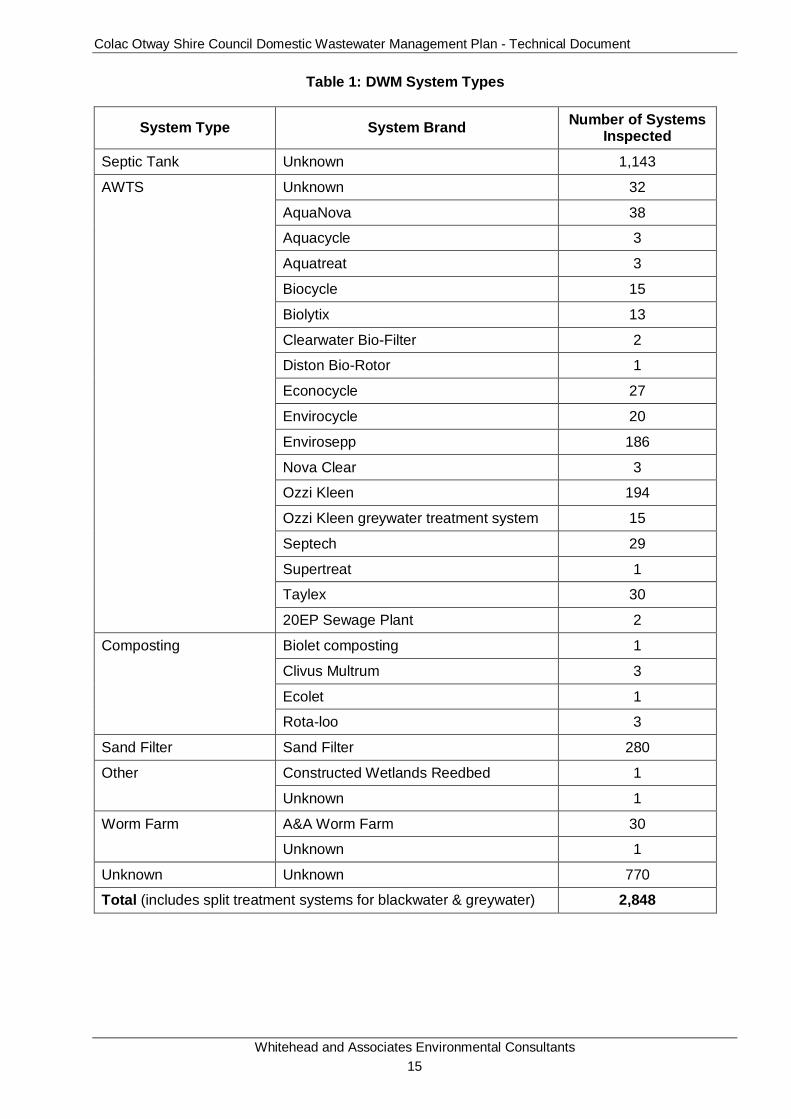
Colac Otway Shire Council Domestic Wastewater Management Plan - Technical Document
Whitehead and Associates Environmental Consultants 15
Table 1: DWM System Types
System Type System Brand Number of Systems Inspected
Septic Tank Unknown 1,143
AWTS Unknown 32
AquaNova 38
Aquacycle 3
Aquatreat 3
Biocycle 15
Biolytix 13
Clearwater Bio-Filter 2
Diston Bio-Rotor 1
Econocycle 27
Envirocycle 20
Envirosepp 186
Nova Clear 3
Ozzi Kleen 194
Ozzi Kleen greywater treatment system 15
Septech 29
Supertreat 1
Taylex 30
20EP Sewage Plant 2
Composting Biolet composting 1
Clivus Multrum 3
Ecolet 1
Rota-loo 3
Sand Filter Sand Filter 280
Other Constructed Wetlands Reedbed 1
Unknown 1
Worm Farm A&A Worm Farm 30
Unknown 1
Unknown Unknown 770
Total (includes split treatment systems for blackwater & greywater) 2,848
Colac Otway Shire Council Domestic Wastewater Management Plan - Technical Document
Whitehead and Associates Environmental Consultants 16
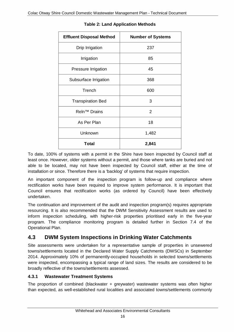
Table 2: Land Application Methods
Effluent Disposal Method Number of Systems
Drip Irrigation 237
Irrigation 85
Pressure Irrigation 45
Subsurface Irrigation 368
Trench 600
Transpiration Bed 3
Reln™ Drains 2
As Per Plan 18
Unknown 1,482
Total 2,841
To date, 100% of systems with a permit in the Shire have been inspected by Council staff at least once. However, older systems without a permit, and those where tanks are buried and not able to be located, may not have been inspected by Council staff, either at the time of installation or since. Therefore there is a ‘backlog’ of systems that require inspection.
An important component of the inspection program is follow-up and compliance where rectification works have been required to improve system performance. It is important that Council ensures that rectification works (as ordered by Council) have been effectively undertaken.
The continuation and improvement of the audit and inspection program(s) requires appropriate resourcing. It is also recommended that the DWM Sensitivity Assessment results are used to inform inspection scheduling, with higher-risk properties prioritised early in the five-year program. The compliance monitoring program is detailed further in Section 7.4 of the Operational Plan.
4.3 DWM System Inspections in Drinking Water Catchments Site assessments were undertaken for a representative sample of properties in unsewered towns/settlements located in the Declared Water Supply Catchments (DWSCs) in September 2014. Approximately 10% of permanently-occupied households in selected towns/settlements were inspected, encompassing a typical range of land sizes. The results are considered to be broadly reflective of the towns/settlements assessed.
4.3.1 Wastewater Treatment Systems The proportion of combined (blackwater + greywater) wastewater systems was often higher than expected, as well-established rural localities and associated towns/settlements commonly
Colac Otway Shire Council Domestic Wastewater Management Plan - Technical Document
Whitehead and Associates Environmental Consultants 17
have separate greywater and blackwater systems. The newer houses (<20 years) were more likely to have combined systems than older houses (>20 years).
Regardless of whether blackwater and greywater streams were separate or combined, septic tanks were often unsatisfactory in terms of accessibility for maintenance, capacity and/or structural integrity. Frequently, septic tanks were buried under more than 150mm of soil, making identification and access difficult and in some cases, the resident/owner was not aware of the septic tank location. Most systems had not been serviced or pumped out within the past 10 years. Many septic tanks allowed stormwater ingress through cracks or gaps alongside the lids, which were typically installed at or below ground level.
There were relatively few secondary treatment systems or greywater treatment systems installed at the inspected properties.
4.3.2 Effluent Disposal Systems Where greywater was managed separately, it was typically directed off-lot, either to the street drain at the front or beyond the back fence (to neighbouring public land or private agricultural land). Due to the cool weather and high rainfall of the inspection period (early spring), effluent did not drain away and was often present in stagnant odorous pools near the point of discharge. In many cases, the direct flow path to nearby surface waters, including drains, creeks and rivers, was less than 100m, posing a high risk to public and environmental health.
Blackwater or combined effluent septic tanks typically discharged to conventional absorption trenches. It was often difficult or impossible to determine the dimensions and layout of trench systems, particularly as wet weather did not cause preferential growth of grass over trenches (as is the case in drier seasons). However, it was evident that many if not most trenches were undersized for the expected wastewater load (number of bedrooms), particularly when the age and potential for ‘creeping failure’1 of the system is taken into account.
However, the existing trenches may be acceptable for the typically small number of occupants of most households (an average of approximately 2 – 2.5 across the Shire, according to ABS 2011 Census data); in which case upgrades may not be immediately necessary.
1 Refers to the progressive clogging of a soil absorption (trench) system along a linear front from the loading end to its terminus.
Colac Otway Shire Council Domestic Wastewater Management Plan - Technical Document
Whitehead and Associates Environmental Consultants 18
5 Preliminary Data Collection (Stage 1) The following section details data acquisition undertaken for the project and used to process information for input into the Sensitivity Analysis. Section 4.1 of the Operational Plan details the methodology and results of the Sensitivity Analysis and overarching Risk Assessment Framework. The background legislative/regulatory requirements are discussed above in Sections 2 and 3.
5.1 Data Acquisition Geographic Information System (GIS) data, covering a wide variety of physical and planning components, has been acquired from COS, the Department of Environment, Land, Water and Planning (DELWP), Wannon Water, Barwon Water, Southern Rural Water, FedUni, Visualising Victoria’s Groundwater (VVG) Project by University of Ballarat and the former Department of Sustainability and the Environment (DSE).
The data obtained included: property and parcel (for targeted localities only) information (cadastre), roads, local government area (LGA) and locality boundaries, sewer network, septic system information, topography, LIDAR, planning scheme zonings and overlays, surface elevation contours (a range of levels), hydrology and drainage, potable reservoirs and offtake points, climate data including rainfall and evapotranspiration, flood prone land (land subject to inundation), 1 in 100 year annual recurrence interval (ARI) flood level, soil landscape, lithology and land system information, groundwater bore locations and information, watertable depths and potable water catchment boundaries. All data was received during late 2014, except for the parcel cadastre layer which was updated as of June 2015.
The GIS data supplied was used for the development of individual constraint maps, informative maps and overlay maps of the Shire. This information provided a comprehensive basis for risk assessment.
5.2 Property (Parcel) Characterisation Using cadastral data supplied by Council, the analysis identified approximately 17,994 ‘properties’, comprising of 24,574 ‘parcels’ within the Shire. For analysis presented throughout the DWMP, the parcel dataset were used within the targeted localities and associated towns/settlements, with the property dataset used for the remainder of the Shire.
All non-developable properties/parcels (i.e. National Park, State Forest, waterway or road etc.) are not included in the unsewered property/parcel count and subsequent analyses in the DWMP. Towns which are currently sewered; including Colac, Apollo Bay, Skenes Creek, Marengo and Birregurra (currently undergoing sewer connections), account for approximately 8,801 properties/parcels within the Shire and have also been excluded from the analysis.
Further, parcels that were <400m2 in area were excluded from the analysis as they represent a land area too small to sustainably accommodate unsewered development (building/associated improvements and DWM) on-site. These areas most likely represent dataset irregularities (i.e. artefacts) or Council or utility sites. There were 246 parcels excluded from further sensitivity analysis within the targeted localities. If necessary, assumptions can be drawn from the constraints of the surrounding properties/parcels.
Based on the raw dataset, and the exclusions described, there are approximately 8,803 unsewered properties/parcels which are not located within reasonable distance to a sewer, or to which no sewer connection exists; although it is not known how many of these are

Colac Otway Shire Council Domestic Wastewater Management Plan - Technical Document
Whitehead and Associates Environmental Consultants 19
developed. The regions excluded from analysis as outlined above are shown as white regions (cadastre) on the subsequent Constraint and Sensitivity Analysis maps.
Some discrepancies may be found between other published total property/parcel numbers and those used, due to issues associated with lot amalgamation and subdivision over time and the current version of cadastre provided by the Council. The cadastre dataset used in this analysis will be progressively updated by Council to include the changes made to the properties/parcels within the Shire overtime.
Colac Otway Shire Council Domestic Wastewater Management Plan - Technical Document
Whitehead and Associates Environmental Consultants 20
6 GIS Data Analysis (Stage 2) 6.1 Domestic Wastewater Management Constraints The individual constraint maps were created using a GIS, through QGIS™, which applied constraint classes for a number of built constraints and land capability constraints, including site and soil parameters. Five constraints were selected, which when consolidated, contribute to assessing the overall land capability for DWM systems, and were used as an input into the Sensitivity Analysis. These were selected based on the availability of digital data, and in the light of experience gained in designing and auditing DWM systems. The discrete constraints selected were:
• Climate;
• Useable Lot Area;
• Current Planning Scheme Zoning Minimum Lot Size Compliance;
• Slope (surface elevation); and
• Soil Suitability.
Sensitivity Analysis mapping refers to all unsewered properties/parcels, irrespective of whether they are developed or not. Properties/parcels that were excluded from the Sensitivity Analysis included those, sewered, zoned Public Park and Recreation Zone, Public Conservation and Resource Zone, and Road Zone as per the COS Planning Scheme, and areas that are categorised as waterbodies in the soil landscape mapping.
Thematic informative maps were also generated for existing lot size, current planning scheme zoning, vegetation, and geology. A sensitivity overlay was developed for landslip hazard and depth to groundwater to assist in refining the final risk rating as necessary for each property/parcel as generated by the Risk Assessment.
There were other parameters that could have been considered in a more detailed constraint assessment; however, such data was not available for this Risk Assessment and the scope of the project did not permit its collection. Nevertheless, the constraints chosen were considered acceptable for the purpose of quantifying the constraints for the broad-scale Risk Assessment outlined in the Operational Plan (2015). The maps have been produced for use at a broad scale (~1:330,000) and the limitations of the data used in the creation of these maps for input in the Sensitivity Analysis must be recognised and is detailed in Section 4.1 in the Operational Plan.
6.2 DWM Constraint Mapping 6.2.1 Constraint Classification Framework For each of the constraints mentioned above, the degree of constraint in relation to DWM for all properties/parcels within the Shire was assessed and individually assigned a constraint class that is then used as an input into the Sensitivity Analysis. The criteria used to determine constraint categories were based on previous constraint assessments for unsewered towns in Australia undertaken by W&A and relevant Australian and Victorian guidelines for DWM.
Table 3 provides a rationale for the interpretations that were used to derive the constraint classes. The constraint classes give guidance towards the DWM requirements as stipulated by Council. For existing DWM systems, the level of constraint will commonly reflect the level of
Colac Otway Shire Council Domestic Wastewater Management Plan - Technical Document
Whitehead and Associates Environmental Consultants 21
challenge that has been experienced in managing the system. This information will help guide property owners and Council in the ongoing management of existing systems.
Table 3: Rationale for DWM Constraint Ratings
Constraint Class Description
Very High
The constraint is present at a very high level and this significantly restricts opportunities for sustainable DWM. Traditional systems are ‘typically’ not appropriate and a detailed site and soil evaluation would be required to determine if DWM is achievable at all. If achievable, specialised, advanced treatment and land application systems may be required to overcome the constraint.
High
The constraint is present at a high level and this substantially restricts opportunities for sustainable DWM. Traditional systems (i.e. septic tanks and trenches) are ‘typically’ not appropriate and a detailed site and soil evaluation would be required to determine if they are supported. Otherwise specialised, advanced treatment and land application systems may be required to overcome the constraint.
Moderate The constraint is present at a moderate level and this limits the range of DWM options that are appropriate for the site. A detailed site and soil evaluation is required to identify the most appropriate DWM system and mitigation measures to be employed.
Low The constraint is present at a low level and is unlikely to substantially limit opportunities for DWM. In most cases appropriately designed and managed conventional systems will be acceptable.
6.2.2 Climate Climate, specifically rainfall and evaporation, plays a significant role in determining the appropriate loading rates of effluent and associated sizing of land application areas for DWM. The climate feature of most interest to DWM is the excess of rainfall over evaporation (more specifically evapotranspiration), which is denoted here as “moisture surplus”. Moisture surplus can result in surface runoff, an increase in soil moisture storage (up to saturation point), and increasing deep infiltration to groundwater.
There are 21 Bureau of Meteorology (BoM) stations located throughout the Shire which record daily rainfall, including five on the Otway Ridge, which receives Victoria’s highest average annual rainfall (up to 1,950mm/year). However, none of these stations measure pan evaporation. The closest station to the Shire that records pan evaporation is at Durdidwarrah, located approximately 45km from the north-eastern Shire boundary. Pan evaporation data for the period 1973-2000 is available at this station.
To overcome this data limitation, this project uses interpolated, gridded data from SILO. SILO (Scientific Information for Land Owners) is a climate and meteorological data service developed and hosted by the Queensland Government, which provides representative data for the entire continent, produced using real climate data collected over long time periods by the BoM. The service provides a realistic representation of a broad range of climate statistics (including rainfall and evapotranspiration) for most areas which are not serviced by local BoM stations. However, it is acknowledged that, due to the sparsity of raw data (BoM) sites and significant orographic influence, the interpolation for the Otway Range tends to underestimate the rainfall along the ridge.
Colac Otway Shire Council Domestic Wastewater Management Plan - Technical Document
Whitehead and Associates Environmental Consultants 22
Monthly rainfall and evapotranspiration data for 64 SILO data points at approximately 0.1 degree (~8.8km) grid spacing’s was collected for the entire Shire. Figure 1 shows the rainfall distribution pattern throughout the Shire based on annual 70th percentile rainfall for each SILO data point. The percentile rainfall data was interpolated using GIS across the Shire to produce a grid with approximately 300m cell size. With the exception of the Otway Ridge rainfall, the data is considered to be a realistic representation of climate patterns throughout the Shire on a long term basis, suitable for use in DWM investigations and designs. The data was also used in the System Sizing Tables, discussed in Section 7.
SILO potential evapotranspiration (ET0) estimates are calculated using the FAO Penman-Monteith formula with a default wind value of 2 m/s. The Penman-Monteith formula also requires radiation, air temperature and humidity as an input. These data are readily available from existing BoM stations.
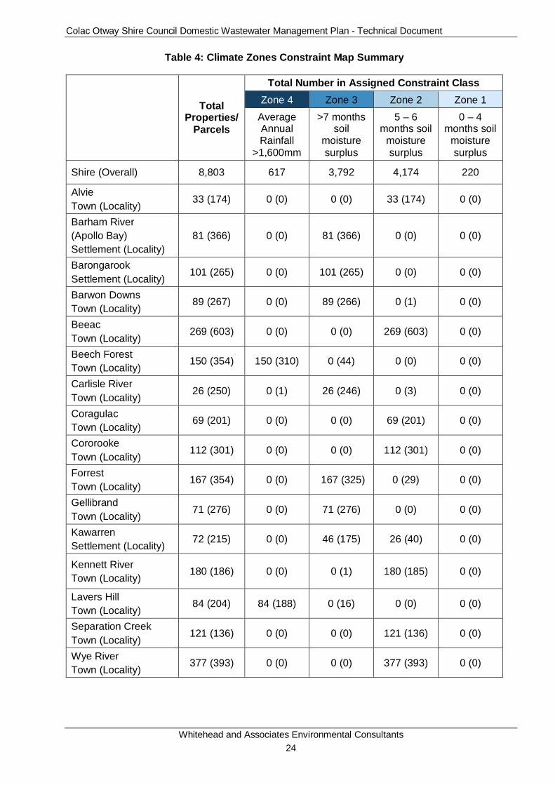
For each SILO data point for each year, the monthly water ‘excess’ totals were calculated by subtracting the total monthly rainfall from total monthly average evapotranspiration. When a water excess occurs within any given month, the rainfall exceeds the evapotranspiration, resulting in meteorological water being retained within the soil profile. From this, the total number of ‘wet’ months for each year were calculated and the median taken for each SILO data point. The number of ‘wet’ months has been gridded and the interpolated values have been converted to the nearest integer. The distribution of the number of ‘wet’ months throughout the Shire is shown in Figure 2. From this, four (4) distinct climate zones were identified based on the number of months where rainfall exceeds evapotranspiration and were categorised as detailed below. Each property/parcel within the Shire was assigned to a climate zone as shown in Figure 3.
• Zone 1: 0 – 4 (soil moisture surplus) months of the year;
• Zone 2: 5 – 6 (soil moisture surplus) months of the year;
• Zone 3: >7 (soil moisture surplus) months of the year; and
• Zone 4: Average Annual Rainfall >1,600mm.
A property/parcel is assigned the more conservative climate zone if it is located along a climate zone boundary. Table 4 details the results of the climate zone constraint analysis for the Shire.
Similarly, the longest run of consecutive ‘wet’ months in each year was also determined and the median longest run was calculated for each SILO data point. The number of consecutive ‘wet’ months has been gridded and the interpolated values have been converted to the nearest integer. The distribution of the number of consecutive ‘wet’ months throughout the Shire is shown in Figure 4.
Overall, there is a strong trend in greater rainfall towards the south of the Shire, particularly along the Otway Range. This is consistent with higher topography and coastal conditions in those regions. The ‘wet’ months are typically found to coincide with the winter calendar months and had a similar increasing trend towards the south of the Shire. All of the targeted localities and towns/settlements are located within climate zones 2 - 4.
The acquired climate data obtained for this assessment is available to Council and will provide a very useful resource for Council in the preparation and review of LCAs in the future. Monthly 70th percentile rainfall and average evapotranspiration data is available for the majority of the unsewered localities and towns/settlements from Council for input into monthly water balances as part of a site specific LCA.

Colac Otway Shire Council Domestic Wastewater Management Plan - Technical Document
Whitehead and Associates Environmental Consultants 23
The climate data that was used in the development of the System Sizing Tables is attached in Appendix C. The BoM 70th percentile rainfall presented in Appendix C should be used instead of the SILO data for all localities along the Otway Ridge (i.e. Beech Forest, Ferguson, Lavers Hill, Wyelangta and Weeaproinah). This appended climate data also includes additional data for surrounding unsewered localities. Land Capability Assessors are also able to use site-specific SILO Data Drill and BoM climate data for LCA reports and DWM designs for particular properties/parcels. The use of such data should be clearly referenced and justified in the LCA report in each instance.
Colac Otway Shire Council Domestic Wastewater Management Plan - Technical Document
Whitehead and Associates Environmental Consultants 24
Table 4: Climate Zones Constraint Map Summary
Total
Properties/Parcels
Total Number in Assigned Constraint Class Zone 4 Zone 3 Zone 2 Zone 1
Average Annual Rainfall
>1,600mm
>7 months soil
moisture surplus
5 – 6 months soil
moisture surplus
0 – 4 months soil
moisture surplus
Shire (Overall) 8,803 617 3,792 4,174 220
Alvie Town (Locality)
33 (174) 0 (0) 0 (0) 33 (174) 0 (0)
Barham River (Apollo Bay) Settlement (Locality)
81 (366) 0 (0) 81 (366) 0 (0) 0 (0)
Barongarook Settlement (Locality)
101 (265) 0 (0) 101 (265) 0 (0) 0 (0)
Barwon Downs Town (Locality)
89 (267) 0 (0) 89 (266) 0 (1) 0 (0)
Beeac Town (Locality)
269 (603) 0 (0) 0 (0) 269 (603) 0 (0)
Beech Forest Town (Locality)
150 (354) 150 (310) 0 (44) 0 (0) 0 (0)
Carlisle River Town (Locality)
26 (250) 0 (1) 26 (246) 0 (3) 0 (0)
Coragulac Town (Locality)
69 (201) 0 (0) 0 (0) 69 (201) 0 (0)
Cororooke Town (Locality)
112 (301) 0 (0) 0 (0) 112 (301) 0 (0)
Forrest Town (Locality)
167 (354) 0 (0) 167 (325) 0 (29) 0 (0)
Gellibrand Town (Locality)
71 (276) 0 (0) 71 (276) 0 (0) 0 (0)
Kawarren Settlement (Locality)
72 (215) 0 (0) 46 (175) 26 (40) 0 (0)
Kennett River Town (Locality)
180 (186) 0 (0) 0 (1) 180 (185) 0 (0)
Lavers Hill Town (Locality)
84 (204) 84 (188) 0 (16) 0 (0) 0 (0)
Separation Creek Town (Locality)
121 (136) 0 (0) 0 (0) 121 (136) 0 (0)
Wye River Town (Locality)
377 (393) 0 (0) 0 (0) 377 (393) 0 (0)
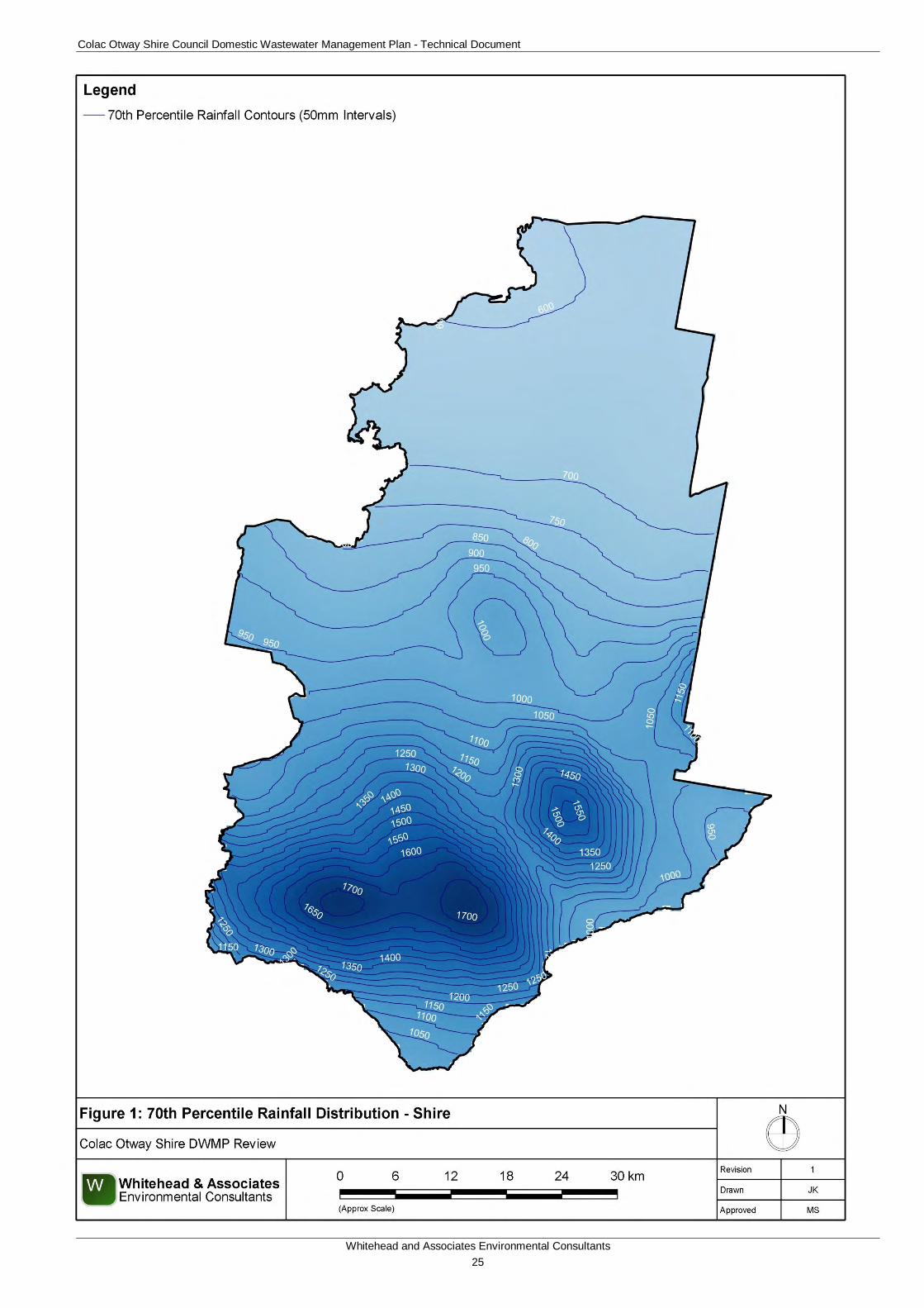
Colac Otway Shire Council Domestic Wastewater Management Plan - Technical Document
Whitehead and Associates Environmental Consultants 25
Figure 1: 70th Percentile Rainfall Distribution - Shire
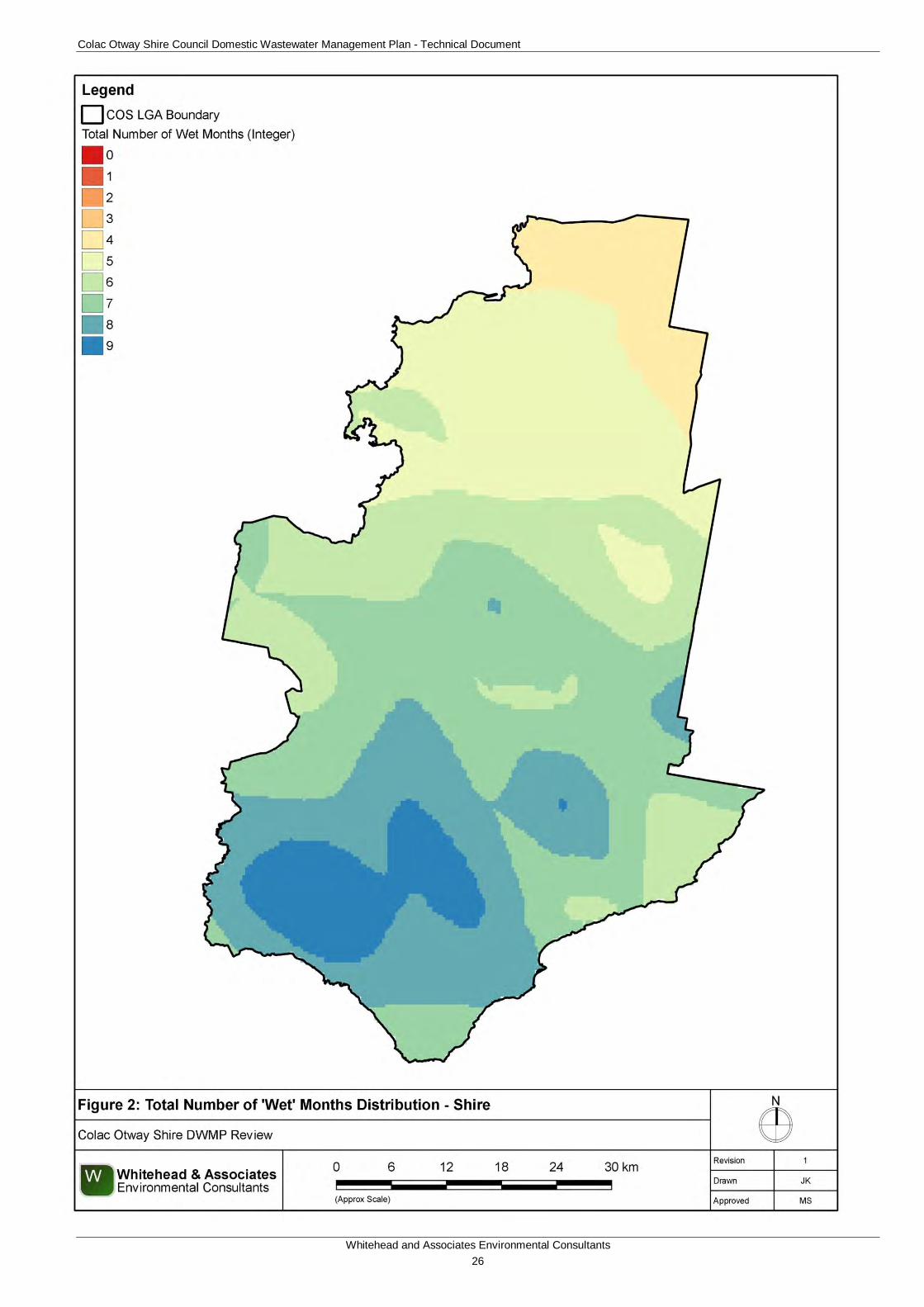
Colac Otway Shire Council Domestic Wastewater Management Plan - Technical Document
Whitehead and Associates Environmental Consultants 26
Figure 2: Total Number of Wet Months Distribution - Shire
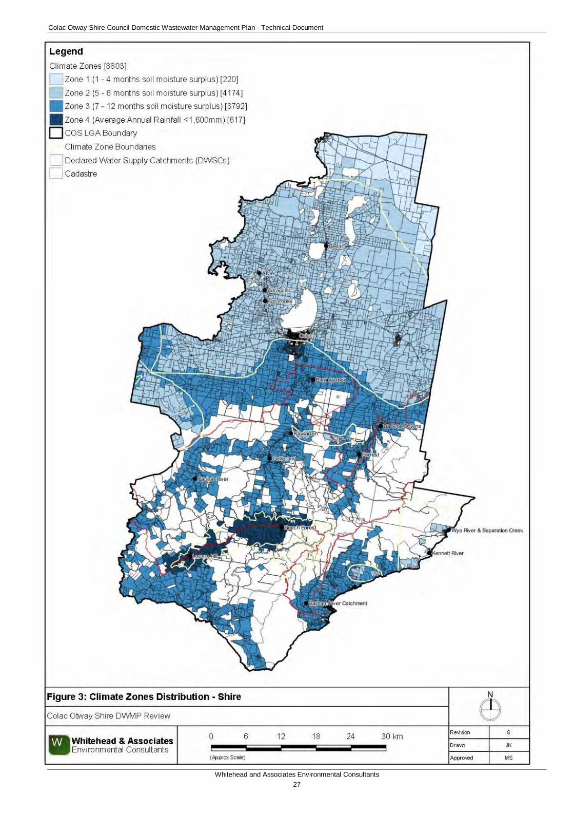
Colac Otway Shire Council Domestic Wastewater Management Plan - Technical Document
Whitehead and Associates Environmental Consultants 27
Figure 3: Climate Zones Distribution - Shire
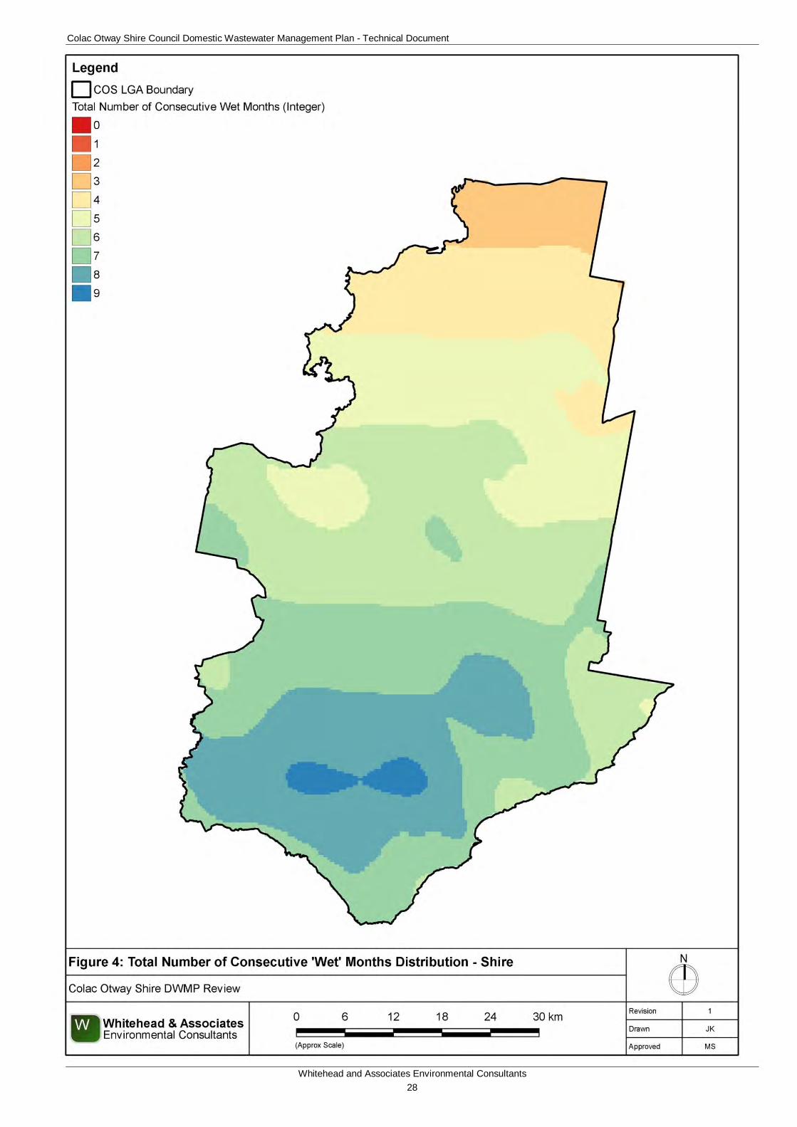
Colac Otway Shire Council Domestic Wastewater Management Plan - Technical Document
Whitehead and Associates Environmental Consultants 28
Figure 4: Total Number of Consecutive Wet Months Distribution - Shire
Colac Otway Shire Council Domestic Wastewater Management Plan - Technical Document
Whitehead and Associates Environmental Consultants 29
6.2.3 Useable Lot Area The potential for sustainable DWM and the determination of suitable DWM system options is dependent on the amount of adequate area available for DWM. The useable lot area for effluent management broadly refers to available land (i.e. not built out or used for a conflicting purpose) where DWM will not be unduly constrained by site and soil characteristics.
The smaller the property/parcel, the more difficult it is to treat and retain wastewater onsite in accordance with legislative requirements. A properly sized land application area provides for long-term, sustainable effluent loading rates that match the assimilative capacity of the soil and vegetation systems. Conversely, improperly designed or undersized land application areas are more likely to fail and lead to potential adverse impacts on both public health and the environment. In recent years, understanding of sustainable effluent loading rates has improved and it is now commonly identified that many older existing systems, such as septic absorption trenches and evapotranspiration beds, are undersized by today’s standards.
Useable lot area, irrespective of total property/parcel size, plays a key role in determining a property/parcel’s capacity for sustainable long-term DWM and influences the selection of appropriate DWM systems. However, as a general rule, the smaller the property/parcel, the less land that will be available for effluent management after allowing for other development on the land. Older development controls and design standards (Codes etc.) did not always consider site-specific land capability constraints and, as a consequence, many existing and vacant residential properties/parcels may be too small to accommodate sustainable DWM systems, particularly by today’s more informed standards.
There is no defined rule about what constitutes an appropriate minimum effluent management area, or in fact minimum useable area that is capable of providing such areas. This will vary depending on the physical constraints present on the property/parcel, the nature of the development, as well as the type of treatment and land application system used. The constraint class boundaries reflect the likelihood of a property/parcel having sufficient effluent management area available after allowing for typical improvements.
There are many factors that determine the available area on any given property/parcel, including:
• Maintenance of appropriate setback buffers from boundaries, buildings, driveways and paths, groundwater bores, dams, intermittent and permanent watercourse; and
• Total development area (including the dwelling, sheds, pools, driveways and garden paths, gardens unsuitable for effluent reuse, and any other hardstand areas, etc.).
Available areas may be unsuitable or constrained for DWM due to other factors, including (but not limited to):
• Excessive slope;
• Excessively shallow soils;
• Heavy (clay) soils with low permeability;
• Climate in regards to the degree of soil moisture surplus;
• Excessively poor drainage and/or stormwater run-on; and
• Excessive shading by vegetation.
Colac Otway Shire Council Domestic Wastewater Management Plan - Technical Document
Whitehead and Associates Environmental Consultants 30
For this study, the useable lot area was determined by the setbacks to surface waterways, groundwater bores and land subject to inundation. The following sections detail the methodology and results for each analysis and the determination of the final useable lot area.
6.2.3.1 Proximity to Surface Waters This section seeks to explain how the distance to waterways, lakes, dams and drinking water catchments influences the useable lot area calculation which forms part of the constraint mapping. This is of particular importance for properties/parcels within the DWSCs.
COS is located entirely within the Corangamite Catchment Management Area (CMA) and consists of the following defined three river basins; Barwon (to the east), Corangamite (north and west), and Otway Coast Basin (to the south).
A large portion (28%) of the Shire is located within a Declared Water Supply Catchment (DWSC). There are seven DWSCs located within the Shire; Gosling Creek, Pennyroyal Creek, Matthew Creek, Upper Barwon, Lorne, Barham River, Gellibrand River, Gellibrand River (South Otway), and Barwon Downs Wellfield Intake. Three of these DWSCs, Upper Barwon, Gellibrand River, and Gellibrand River (South Otway), have Special Area Plans. These DWSCs are detailed on the ‘proximity to surface waterways informative map’ in Appendix A and regionally below in Figure 5.
Buffer distances (setbacks) are usually provided between land application areas and sensitive receptors, such as surface watercourses, to help prevent adverse impacts on water quality, particularly should the DWM system fail. There is no simple and defined method for objectively determining safe buffer distances, so regulators often recommend conservative, minimum buffer distances that would be expected to satisfy the objective in the majority of situations.
The current EPA Code of Practice recommends three tiers of setback distances from surface waterways that are applicable to the Shire. Further, the Code specifies differing setback distances for primary (i.e. septic/trench) systems and secondary (or greywater) systems. The following (primary) buffers have been conservatively adopted and applied to the appropriate surface watercourse/waterway using data (1:25,000 scale) provided by DELWP. The resultant map is appended in Appendix A.
• 60m for non-potable watercourses, dams, wetlands, estuaries and surface water features (including the mean coastal high-tide mark and dams);
• 100m for potable watercourses2 and surface waterway river bodies; and
• 300m for potable reservoirs or storages.
300m setbacks, similar to those applied for potable reservoirs, were also applied to the Water Corporation source points (i.e. offtake points, weirs, pumping stations, etc.) to ensure that the sensitivity of these local environments are accounted for.
No setbacks were applied to man-made drains or waterfalls, which would likely be accounted for within other watercourse/waterway setbacks.
Intuitively, the risk of DWM systems impacting on nearby receiving areas increases with decreasing separation distance. For a broad-scale risk assessment, it is appropriate to analyse
2 It should be noted that the surface water map does not distinguish between permanent and intermittent watercourses. Diversion channels have been defined as a watercourse for this particular purpose.
Colac Otway Shire Council Domestic Wastewater Management Plan - Technical Document
Whitehead and Associates Environmental Consultants 31
the separation distances that are available on a property/parcel basis and assign constraint classes accordingly.
AS/NZS 1547:2012 details instances where recommended setbacks from sensitive receptors can be relaxed to accommodate certain types of systems where standard buffer distances cannot be achieved. These systems would require individual assessment and design in order to meet the requirements of the Standard.
For properties/parcels constrained by proximity to surface waters, it might be possible to mitigate this constraint by:
• Secondary treatment with an AWTS or sand filter;
• Moving the LAA to increase buffer distance; or
• Replacing surface irrigation with subsurface irrigation.
As mentioned previously in Section 3.2.5, water services within the Shire are provided primarily by Barwon Water, with water also supplied by Southern Rural Water to the north of the Shire and by Wannon Water to the town of Carlisle River. Both Barwon Water and Wannon Water are referral authorities for developments within the DWSCs within the southern region of the Shire. The referral authorities for each DWSC in the Shire are detailed within Clause 66.04 and Schedule 3 of the Environmental Significance Overlay (ES03) of the COS Planning Scheme.
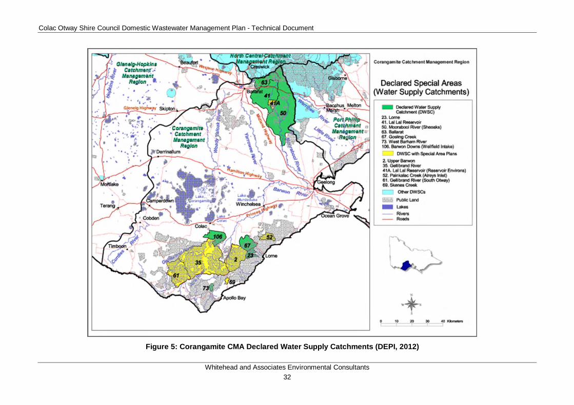
Colac Otway Shire Council Domestic Wastewater Management Plan - Technical Document
Whitehead and Associates Environmental Consultants 32
Figure 5: Corangamite CMA Declared Water Supply Catchments (DEPI, 2012)
Colac Otway Shire Council Domestic Wastewater Management Plan - Technical Document
Whitehead and Associates Environmental Consultants 33
6.2.3.2 Proximity to Groundwater Bores This section seeks to explain how the distance from DWM systems to groundwater bores can affect the quality of groundwater.
The principal groundwater resources in Victoria fall south of the Great Dividing Range and are generally contained in Tertiary or younger unconsolidated sediments. The Shire is located within the Otway-Torquay groundwater basins, within the Hopkins-Corangamite and Otway-Torquay groundwater catchment areas.
A Groundwater Management Unit refers to either a Groundwater Management Area or Water Supply Protection Area as determined within the Groundwater Catchment. Water Supply Protection Area(s) (WSPAs) are declared under Section 27 of the Water Act 1989 to protect groundwater or surface water resources through the development of a management plan which aims for equitable management and long-term sustainability. There are nineteen WSPA declared in Victoria. A Groundwater Management Area(s) (GMAs) is defined as an area where groundwater of a suitable quality for irrigation, commercial or domestic and stock use is available or expected to be available. There are 34 GMAs declared in Victoria. There are four GMAs found within the Shire; Gerangamete to the east (60m depth), Gellibrand centrally located (at or near surface), Paaratte to the west (>120m depth) and Newlingrook to the west (at or near surface). There is one declared WSPA within the Shire; Warrion WSPA, which is located within the north east of the Shire and within the targeted localities of Alvie, Cororooke and Coragulac. This is managed by Southern Rural Water. The western edge of Lake Corangamite forms the administrative boundary between Colac Otway Shire and Corangamite Shire Council and also a natural hydrogeological boundary to the Warrion WSPA. The principal aquifer is unconfined and predominantly consists of volcanic material, including fractured basalt and scoria. There is also a potential of the Hanson Plains Sand aquifer underlying the volcanic aquifer supplying groundwater to this system. DELWP and Southern Rural Water, on behalf of the Minister of Water, jointly monitor and manage groundwater resources within the Shire.
The location of land application areas in close proximity to groundwater bores increases the potential for contamination of the groundwater. When water is extracted from the groundwater bores a zone of influence is created, whereby the head level of the groundwater is altered. Buffer distances (setbacks) are recommended between land application areas and both potable and non-potable groundwater bores. The current EPA Code of Practice recommends a 50m setback (for Category 1 and 2a soils) and 20m setback3 (for Category 2b to 6 soils) be maintained from such resources to protect human health. A conservative approach was taken when developing this DWMP and a setback distance of 50m was used for all the groundwater bores located within the Shire.
The spatial data of the groundwater bore locations within the Shire was acquired from the Water Measurement Information System (WMIS) Database Interface as managed by DELWP. Using GIS, the recommended groundwater buffer setback was applied to all of the groundwater bores located within the Shire. There was a total of 2,329 groundwater bores that were identified within the Shire. The resultant map is appended in Appendix A.
As previously mentioned, AS/NZS 1547:2012 details instances where recommended setbacks can be relaxed to accommodate certain types of systems where standard buffer distances cannot be achieved. In most cases, the preferred result would be to have the identified bores
3 For secondary sewage and greywater effluent

Colac Otway Shire Council Domestic Wastewater Management Plan - Technical Document
Whitehead and Associates Environmental Consultants 34
condemned and capped to prevent further use, negating the need for setbacks from these resources. However, it is acknowledged that this outcome would not be acceptable to some owners who utilise the resource.
For properties/parcels constrained by proximity to groundwater bores, it might be possible to mitigate the constraint by:
• Secondary treatment with an AWTS or sand filter;
• Moving LAA to increase buffer distance; or
• Replacing surface irrigation with subsurface irrigation.
6.2.3.3 Land Subject to Inundation The DWM system, including any tanks, fields or trenches should be sited above any land subject to inundation.
Land that is subjected to frequent or intermittent inundation by floodwater has a significantly higher constraint for effective on-site DWM. Effluent management areas should not be located within flood prone regions as floodwaters have a higher probability of inundation leading to insufficient treatment of the effluent and an increase in potential environmental and public health risks.
Flood prone land, in the case of this report, is defined as land that is subject to inundation based on the 1 in 100 year flood level (1% Annual Exceedance Probability (AEP)) that delineates the areas likely to be inundated through statistical modelling or as determined by the floodplain management authority. Land subject to inundation was buffered from the useable lot area; the resultant map is appended in Appendix A.
It might be possible to mitigate the properties/parcels constrained by flood prone land by:
• Secondary treatment with an AWTS or sand filter;
• Using pressure compensating subsurface irrigation; or
• Raising level of application by constructing a raised bed or sand mound.
6.2.3.4 Useable Lot Area Analysis The cadastre data set supplied by Council was queried to determine the spatial relationship between each property/parcel, its existing land area and the buffer zones (cohesively) to determine the useable lot area for each property/parcel within the Shire; whether developed or not. The following criteria were used to determine the useable lot area classification with regards to DWM suitability:
• High: useable area <0.15ha;
• Moderate: useable area 0.15 – 0.4ha;
• Low: useable area 0.4 – 40ha; and
• Compliant: useable area >40ha.
Properties/parcels containing less than 0.15ha of useable area invariably have a very limited available effluent management area and so DWM contained entirely on-site is in the vast majority of cases unsustainable, necessitating site specific hydraulic design for wastewater management. This is based on an assumed footprint of 500m2 for an average building envelope
Colac Otway Shire Council Domestic Wastewater Management Plan - Technical Document
Whitehead and Associates Environmental Consultants 35
and improvements (e.g. driveway) and allowing for an average appropriately sized LAA and reserve LAA on the remainder of the property/parcel.
If DWM is to be provided, it will be necessary to provide a high level of treatment and specialised land application design using systems such as sand mounds or pressurised subsurface irrigation, to ensure long term sustainability. Other mitigation measures like the adoption of water conserving practices will be important in ensuring the system’s effectiveness. Such systems are likely to have limited opportunity for expansion, as may be required if the household wastewater load changes in response to increased occupancy, or if a new reticulated water supply becomes available. It should be taken into consideration that a property/parcel <0.15ha will not necessarily be totally unsuitable for DWM or currently be serviced by a failing system; however, it is likely to contain a number of significant limitations to the safe operation of DWM systems assessed at a broad scale.
In the case of properties/parcels with areas between 0.15ha and 0.4ha, and in the absence of any other significant physical constraints, the availability of land for effluent management usually increases proportionately with a corresponding improvement in the potential for sustainable DWM. The choice of options is likely to be slightly greater than that available for properties/parcels with useable area less than 0.4ha; however, detailed site and soil investigation is still important to identify the most appropriate solution as other bio-geophysical constraints may limit opportunities for sustainable DWM. Again, conventional systems may not be appropriate for these sites. These properties/parcels have been assigned a ‘moderate’ overall constraint class.
In most cases, properties/parcels larger than 0.4ha will have far fewer problems providing sufficient space for sustainable on-site DWM. For this reason these properties/parcels have been assigned a ’low’ constraint class. Overall constraint for DWM for these properties/parcels will be determined by the land capability constraints.
Properties/parcels with a useable area larger than 40ha already meet the criteria prescribed by the Minister for Water’s Guidelines (DSE, 2012) and are deemed to be compliant.
For properties/parcels constrained by useable area, it might be possible to mitigate this constraint by:
• Secondary treatment with an AWTS or sand filter;
• Secondary treatment with land application to trenches at higher loading rates as outlined in AS/NZS 1547:2012; or
• Increasing loading rate by use of sand mound.
Table 5 details the results of the useable lot area constraint analysis for the Shire. The associated DWM constraint map for the Shire is provided as Figure 6.
Colac Otway Shire Council Domestic Wastewater Management Plan - Technical Document
Whitehead and Associates Environmental Consultants 36
Table 5: Useable Lot Area Constraint Map Summary
Total
Properties/Parcels
Total Number in Assigned Constraint Class High Moderate Low Compliant
<0.15ha 0.15 – 0.4ha
0.4ha – 40ha >40ha
Shire (Overall) 8,803 2,188 826 4,833 956
Alvie Town (Locality) 33 (174) 12 (23) 11 (27) 10 (111) 0 (13)
Barham River (Apollo Bay) Settlement (Locality)
81 (366) 16 (76) 8 (24) 56 (260) 1 (6)
Barongarook Settlement (Locality) 101 (265) 18 (26) 6 (16) 77 (216) 0 (7)
Barwon Downs Town (Locality) 89 (267) 43 (77) 23 (29) 23 (154) 0 (7)
Beeac Town (Locality) 269 (603) 198 (236) 58 (80) 12 (275) 1 (12)
Beech Forest Town (Locality) 150 (354) 98 (125) 39 (67) 13 (146) 0 (16)
Carlisle River Town (Locality) 26 (250) 10 (41) 5 (16) 11 (170) 0 (23)
Coragulac Town (Locality) 69 (201) 26 (41) 16 (33) 27 (125) 0 (2)
Cororooke Town (Locality) 112 (301) 69 (95) 26 (45) 17 (158) 0 (3)
Forrest Town (Locality) 167 (354) 88 (129) 55 (62) 24 (157) 0 (6)
Gellibrand Town (Locality) 71 (276) 19 (58) 33 (46) 19 (158) 0 (14)
Kawarren Settlement (Locality) 72 (215) 37 (72) 6 (16) 29 (121) 0 (6)
Kennett River Town (Locality) 180 (186) 173 (175) 6 (8) 1 (2) 0 (1)
Lavers Hill Town (Locality) 84 (204) 52 (65) 20 (26) 12 (97) 0 (16)
Separation Creek Town (Locality) 121 (136) 119 (122) 1 (4) 1 (10) 0 (0)
Wye River Town (Locality) 377 (393) 330 (334) 45 (45) 2 (11) 0 (3)
Colac Otway Shire Council Domestic Wastewater Management Plan - Technical Document
Whitehead and Associates Environmental Consultants 37
Figure 6: DWM Constraint Analysis - Useable Lot Area - Shire
Colac Otway Shire Council Domestic Wastewater Management Plan - Technical Document
Whitehead and Associates Environmental Consultants 38
6.2.4 Current Planning Scheme Zone - Minimum Lot Size Compliance As discussed in Section 6.2.3, area plays a key role in determining a property/parcel’s capacity for sustainable long-term DWM and influences the selection of appropriate DWM systems. The COS Planning Scheme sets out policies and requirements for the use, development, subdivision and protection of land. The requirements and particular provisions for each zone are detailed within the COS Planning Scheme. The current zonings for the Shire were thematically mapped to assist Council with future development opportunities and identification of constraints in relation to DWM.
COS is seeking a relaxation of Guideline 1 of the Guidelines for Planning permit applications in open, potable water supply catchment areas (DSE, 2012) from the Water Corporations. If this relaxation is granted and a higher density of development within a DWSC is sought, then one of the requirements that must still be adhered to in accordance with ‘Planning permit applications in open, potable water supply catchment areas’ is that the minimum lot size specified for that zone must be met. The planning scheme zones were summarised into the fifteen (15) following zones and are appended as a thematic map in Appendix A:
• General Residential;
• Neighbourhood Residential;
• Township;
• Low Density Residential;
• Farming;
• Rural Activity;
• Rural Conservation;
• Rural Living;
• Commercial (1 & 2);
• Industrial (1 & 3)
• Public Park and Recreation;
• Public Conservation and Resource;
• Public Use;
• Road; and
• Special Use.
The majority of the Shire is in three zonings; Farming Zone in the northern section of the municipality, Public Conservation and Resource Zone in the southern region (relative to the Otway Ranges) and Rural Conservation Zone along the coastline.
Along with sewered properties/parcels, land zoned Road Zone, Public Park and Recreation Zone and Public Conservation and Resource Zone, was excluded from the cadastral dataset as the suitability of this land for on-site DWM is irrelevant. A vegetation informative map was generated to provide a visual distribution of the National Parks and State Forests within COS and is attached in Appendix A.

Colac Otway Shire Council Domestic Wastewater Management Plan - Technical Document
Whitehead and Associates Environmental Consultants 39
Existing land area and current zoning of the properties/parcels as per the COS Planning Scheme were used to determine whether existing properties/parcels complied with the minimum lot size as per the current zoning requirements. The existing lot size was compared with the minimum lot size specified for the prescribed zone for each lot to determine its compliance.
Table 6 details the results of the minimum lot size compliance with the planning scheme zoning requirements for the Shire. The associated DWM discrete constraint map for the Shire is provided as Figure 7.
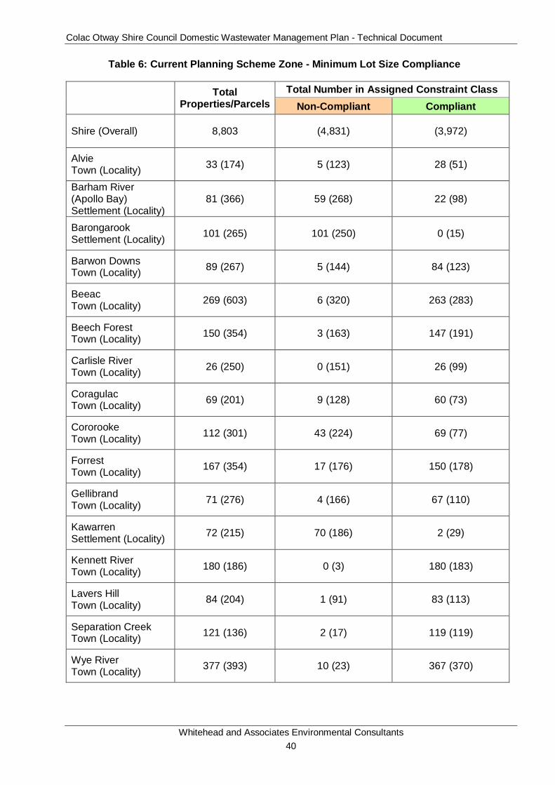
Colac Otway Shire Council Domestic Wastewater Management Plan - Technical Document
Whitehead and Associates Environmental Consultants 40
Table 6: Current Planning Scheme Zone - Minimum Lot Size Compliance
Total Properties/Parcels
Total Number in Assigned Constraint Class Non-Compliant Compliant
Shire (Overall) 8,803 (4,831) (3,972)
Alvie Town (Locality) 33 (174) 5 (123) 28 (51)
Barham River (Apollo Bay) Settlement (Locality)
81 (366) 59 (268) 22 (98)
Barongarook Settlement (Locality) 101 (265) 101 (250) 0 (15)
Barwon Downs Town (Locality) 89 (267) 5 (144) 84 (123)
Beeac Town (Locality) 269 (603) 6 (320) 263 (283)
Beech Forest Town (Locality) 150 (354) 3 (163) 147 (191)
Carlisle River Town (Locality) 26 (250) 0 (151) 26 (99)
Coragulac Town (Locality) 69 (201) 9 (128) 60 (73)
Cororooke Town (Locality) 112 (301) 43 (224) 69 (77)
Forrest Town (Locality) 167 (354) 17 (176) 150 (178)
Gellibrand Town (Locality) 71 (276) 4 (166) 67 (110)
Kawarren Settlement (Locality) 72 (215) 70 (186) 2 (29)
Kennett River Town (Locality) 180 (186) 0 (3) 180 (183)
Lavers Hill Town (Locality) 84 (204) 1 (91) 83 (113)
Separation Creek Town (Locality) 121 (136) 2 (17) 119 (119)
Wye River Town (Locality) 377 (393) 10 (23) 367 (370)
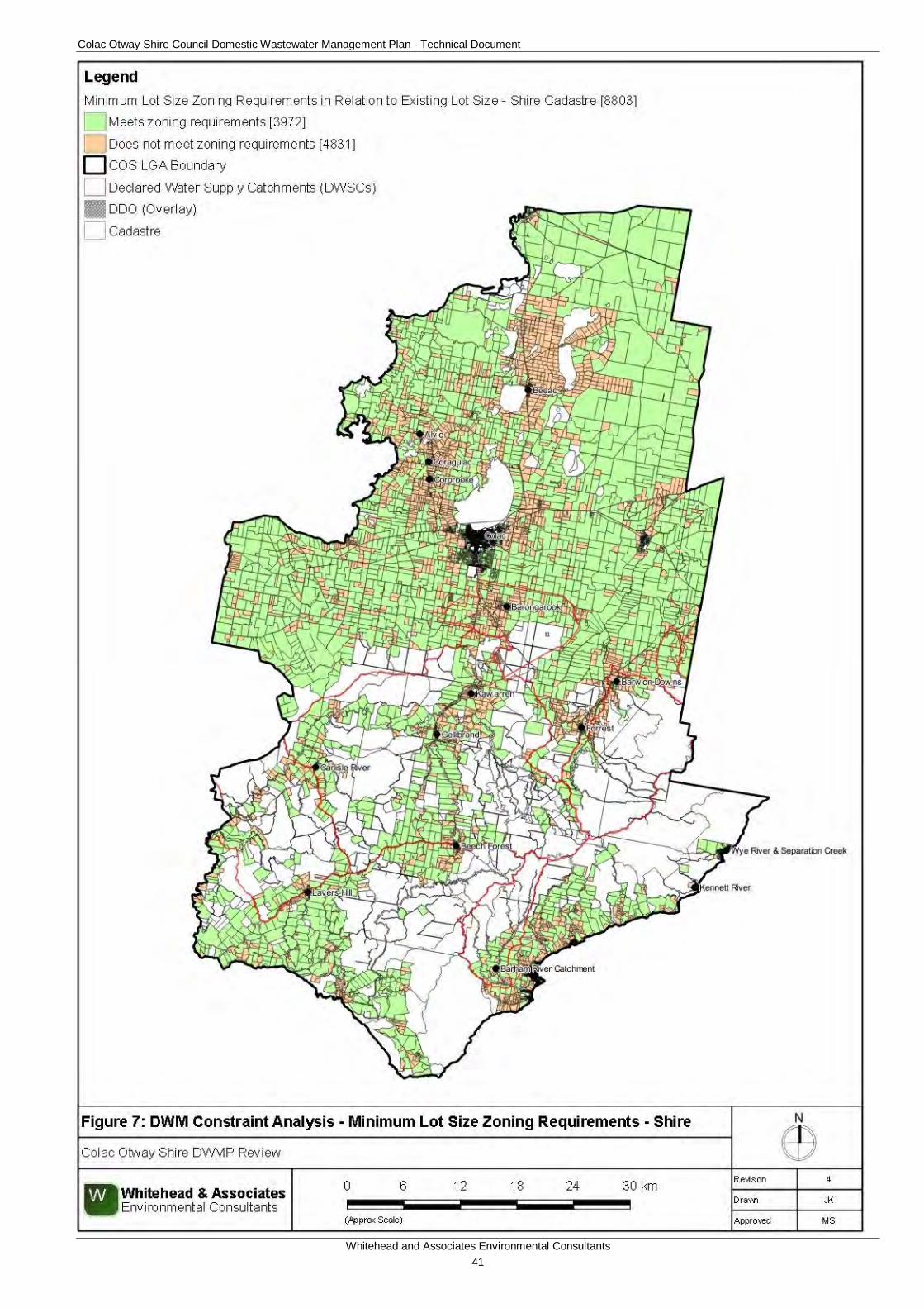
Colac Otway Shire Council Domestic Wastewater Management Plan - Technical Document
Whitehead and Associates Environmental Consultants 41
Figure 7: Minimum Lot Size Zoning Requirements - Shire
Colac Otway Shire Council Domestic Wastewater Management Plan - Technical Document
Whitehead and Associates Environmental Consultants 42
6.2.5 Slope The slope of the land affects what type, or even whether you can have, any wastewater disposal on the land. This is closely linked to the soil type and the soil’s absorption capabilities.
AS/NZS 1547:2012 (Table K1) details a range of factors likely to limit the selection and applicability of land application systems, with slope gradient identified as one critical factor.
Steep slopes, particularly when combined with shallow or poorly drained soils, can lead to surface breakout of effluent downslope of the land application area. Conventional DWM systems are likely to be unsuitable and these properties/parcels will require a detailed site assessment and specific system design to produce a sustainable outcome. These steeply sloping sites are generally unsuitable for trenches and beds and can also be problematic for surface irrigation techniques. Conversely, flat and gently sloping sites are less likely to experience such problems and are considered lower risk.
Surface elevation for the Shire was gridded with a maximum cell size of 20m for the entire Shire and 5m for the localities (including the towns/settlements), with no vertical exaggeration to create a DEM. Where the 5m grids were derived, they took precedence over the 20m grid and an overall combined DEM was generated which is shown in Figure 8. The surface elevation for the Shire ranges from approximately 0m to 630m Australian Height Datum (AHD). Gridded slope data was derived from the DEM and combined with the cadastre data set to calculate the average slope as percent grade for each property/parcel within the Shire. The average slope was based on the centroid of each property/parcel. The slope ranged from 0 – 138%.
The following criteria were used to determine the DWM constraint classification on the average property/parcel slope:
• High: properties/parcels that have an average slope greater than 12%;
• Moderate: properties/parcels that have an average slope, inclusive of, and between 8% and 12%; and
• Low: properties/parcels that have an average slope less than 8%.
For properties/parcels constrained by steep slope, it might be possible to mitigate this constraint by:
• Applying a lower soil (effluent) loading rate over a larger area;
• Designing an irrigation system to ensure even distribution of effluent over the slope; or
• Terracing to create a level LAA.
Table 7 details the results of the average property/parcel slope constraint analysis for the Shire. The associated DWM discrete constraint map for the Shire is provided as Figure 9.
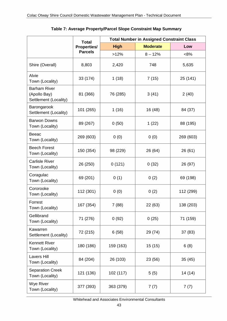
Colac Otway Shire Council Domestic Wastewater Management Plan - Technical Document
Whitehead and Associates Environmental Consultants 43
Table 7: Average Property/Parcel Slope Constraint Map Summary
Total
Properties/Parcels
Total Number in Assigned Constraint Class
High Moderate Low
>12% 8 – 12% <8%
Shire (Overall) 8,803 2,420 748 5,635
Alvie Town (Locality)
33 (174) 1 (18) 7 (15) 25 (141)
Barham River (Apollo Bay) Settlement (Locality)
81 (366) 76 (285) 3 (41) 2 (40)
Barongarook Settlement (Locality)
101 (265) 1 (16) 16 (48) 84 (37)
Barwon Downs Town (Locality)
89 (267) 0 (50) 1 (22) 88 (195)
Beeac Town (Locality)
269 (603) 0 (0) 0 (0) 269 (603)
Beech Forest Town (Locality)
150 (354) 98 (229) 26 (64) 26 (61)
Carlisle River Town (Locality)
26 (250) 0 (121) 0 (32) 26 (97)
Coragulac Town (Locality)
69 (201) 0 (1) 0 (2) 69 (198)
Cororooke Town (Locality) 112 (301) 0 (0) 0 (2) 112 (299)
Forrest Town (Locality)
167 (354) 7 (88) 22 (63) 138 (203)
Gellibrand Town (Locality) 71 (276) 0 (92) 0 (25) 71 (159)
Kawarren Settlement (Locality)
72 (215) 6 (58) 29 (74) 37 (83)
Kennett River Town (Locality)
180 (186) 159 (163) 15 (15) 6 (8)
Lavers Hill Town (Locality)
84 (204) 26 (103) 23 (56) 35 (45)
Separation Creek Town (Locality)
121 (136) 102 (117) 5 (5) 14 (14)
Wye River Town (Locality)
377 (393) 363 (379) 7 (7) 7 (7)
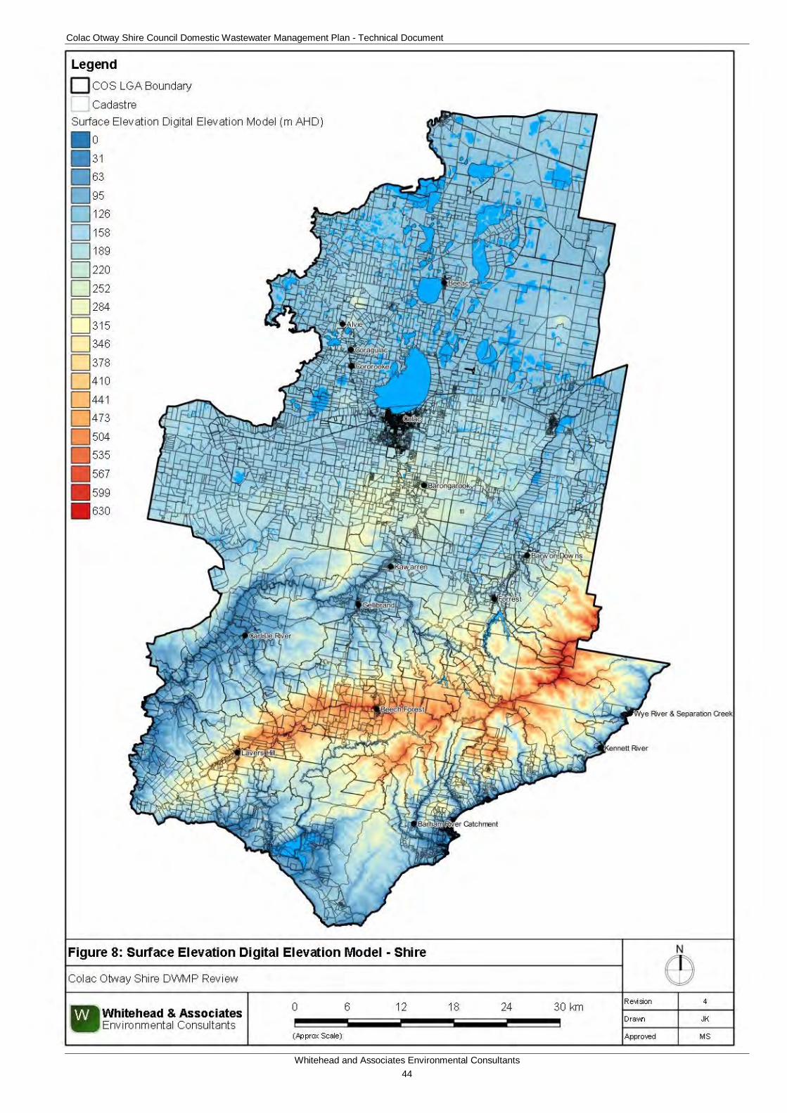
Colac Otway Shire Council Domestic Wastewater Management Plan - Technical Document
Whitehead and Associates Environmental Consultants 44
Figure 8: Surface Elevation Digital Elevation Model - Shire
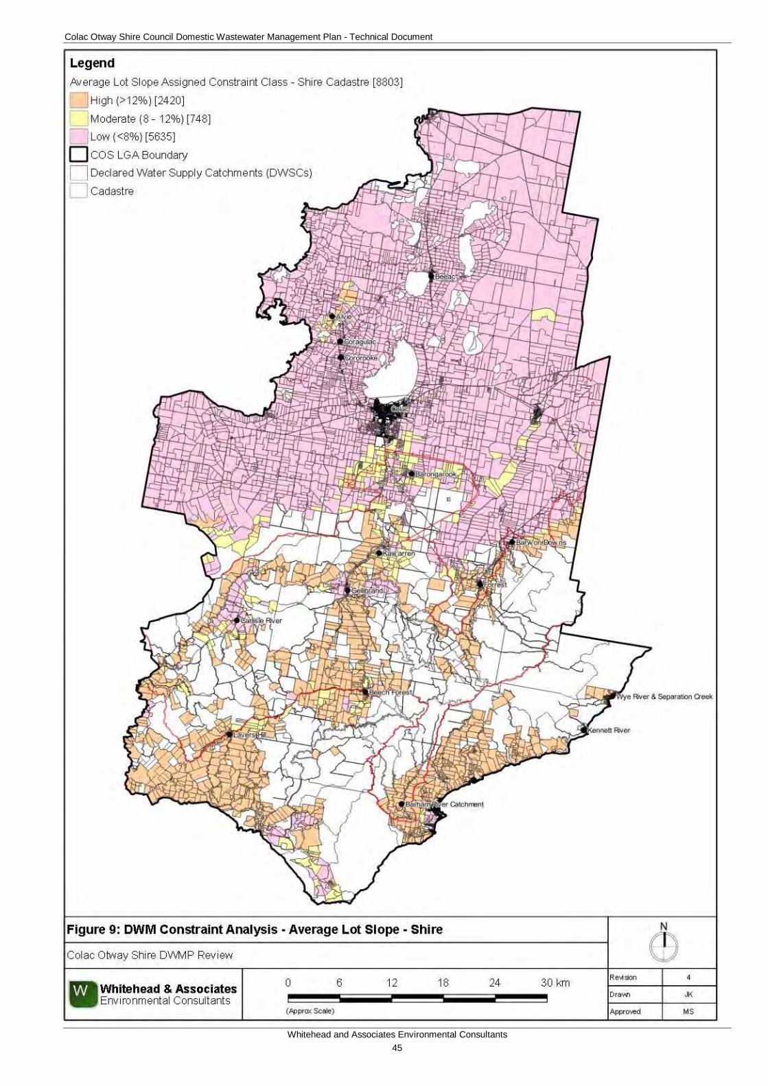
Colac Otway Shire Council Domestic Wastewater Management Plan - Technical Document
Whitehead and Associates Environmental Consultants 45
Figure 9: DWM Constraint Analysis - Average Lot Slope - Shire
Colac Otway Shire Council Domestic Wastewater Management Plan - Technical Document
Whitehead and Associates Environmental Consultants 46
6.2.6 Soil Suitability Geology was also used as a reference towards the understanding of the soil and landform characteristics of the Shire.
The soil type and its absorption capabilities in this report refer to effluent treatment and what type of wastewater system is suitable. Soil that is not suitable for effluent treatment may be ideal for other uses such as farming and vice versa.
Soils and landform elements, along with associated lithology, play a vital role in the design, operation and performance of DWM systems. Key soil properties can be evaluated to assess a soil’s capacity for absorption of wastewater, including soil texture, structure, depth, permeability, drainage characteristics, and depth to limiting layers such as bedrock, hardpans or watertables.
The surface geology of the Shire is shown in Figure 10 and the geological units were based on the ‘Surface Geology of Victoria’ dataset (1:250,000) that was obtained from GeoSciences Victoria (DEPI, 2011). The Shire is underlain by twenty-three (23) different surface lithological groups, with the northern region and the Otway Ranges underlain primarily by the Newer Volcanic Group and Eumeralla Formation, respectively.
The most current soil-landform unit datasets were obtained from DELWP. The most current dataset, ‘A Land Resource Assessment (LRA) of the Corangamite Region’ (Robinson et al., 2003), was used as the basis for the determination of soil suitability for DWM. The LRA draws substantially on earlier geology mapping and soil surveys, in particular those of Maher and Martin (1987) and Pitt (1981). Industry specific site investigations for dairying and cropping, a survey on a gas pipeline, and regional extension activities have provided other soil profile data. The purpose for this LRA was to integrate, within a new geomorphic framework for Victoria, map units and boundaries published in the earlier surveys to derive a consistent report and mapping for the region. The data (1:100,000) can only be effectively used as a strategic mapping tool for regional targeting of resources based on the location of susceptibilities in conjunction with other factors.
The LRA dataset provided different information on various soil and landform characteristics of the region; including, landform elements, slope, vegetation, soil description (Australian Soil Classification), topsoil and subsoil texture, depth of soil profile, soil structure, soil chemical characteristics, and many other productivity and land degradation constraints. There were fifty-seven (57) different soil landform units identified within the Shire. Figure 11 thematically identifies the different soil landform units and their associated locations. Refer to the accompanying LCA reports4 for additional detailed descriptions on each of the soil landform units.
It is important to note that soil landform units are not homogeneous. Importantly, it should be noted that, at this mapping scale, soil attributes are expected to vary within soil landform units. Due to the degree of variance within each soil landform unit (e.g. due to the soil catena), the soil characteristics with the most dominant landform element proportion (e.g. greatest percentage) were used as a representation for that soil landform unit. Refer to the accompanying LCA reports for site specific data. Site specific investigations are required to confirm the broad scale assessment of the soil landform units, as the presence of a minor soil landform component could result in varying attributes to the predominant component used for the soil suitability constraint analysis.
4 http://vro.depi.vic.gov.au/dpi/vro/vrosite.nsf/pages/soil-home
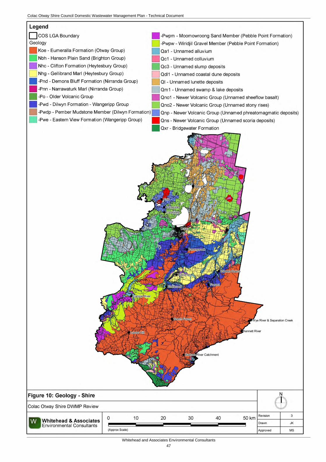
Colac Otway Shire Council Domestic Wastewater Management Plan - Technical Document
Whitehead and Associates Environmental Consultants 47
Figure 10: Surface Geology – Shire
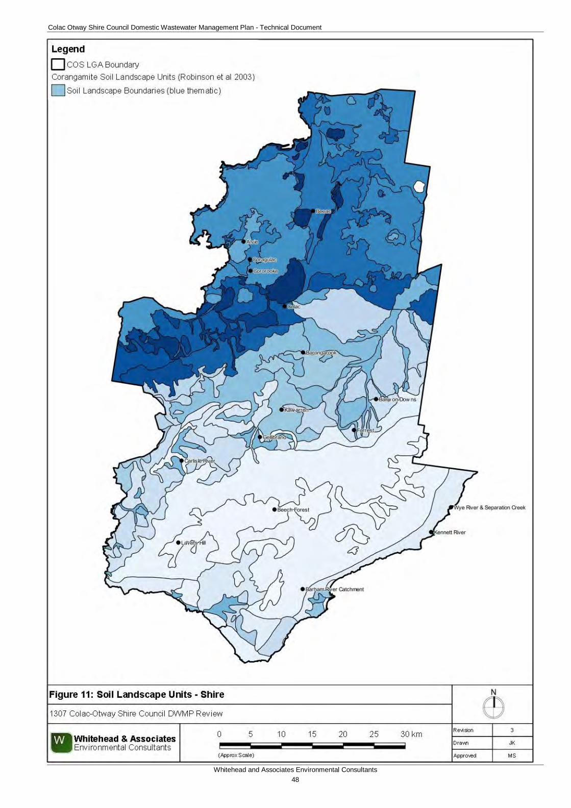
Colac Otway Shire Council Domestic Wastewater Management Plan - Technical Document
Whitehead and Associates Environmental Consultants 48
Figure 11: Soil Landform Units - Shire
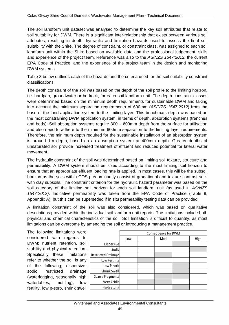
Colac Otway Shire Council Domestic Wastewater Management Plan - Technical Document
Whitehead and Associates Environmental Consultants 49
The soil landform unit dataset was analysed to determine the key soil attributes that relate to soil suitability for DWM. There is a significant inter-relationship that exists between various soil attributes, resulting in depth, hydraulic and limitation hazards used to assess the final soil suitability with the Shire. The degree of constraint, or constraint class, was assigned to each soil landform unit within the Shire based on available data and the professional judgement, skills and experience of the project team. Reference was also to the AS/NZS 1547:2012, the current EPA Code of Practice, and the experience of the project team in the design and monitoring DWM systems.
Table 8 below outlines each of the hazards and the criteria used for the soil suitability constraint classifications.
The depth constraint of the soil was based on the depth of the soil profile to the limiting horizon, i.e. hardpan, groundwater or bedrock, for each soil landform unit. The depth constraint classes were determined based on the minimum depth requirements for sustainable DWM and taking into account the minimum separation requirements of 600mm (AS/NZS 1547:2012) from the base of the land application system to the limiting layer. This benchmark depth was based on the most constraining DWM application system, in terms of depth, absorption systems (trenches and beds). Soil absorption systems require 300 – 600mm depth from the surface for utilisation and also need to adhere to the minimum 600mm separation to the limiting layer requirements. Therefore, the minimum depth required for the sustainable installation of an absorption system is around 1m depth, based on an absorption system at 400mm depth. Greater depths of unsaturated soil provide increased treatment of effluent and reduced potential for lateral water movement.
The hydraulic constraint of the soil was determined based on limiting soil texture, structure and permeability. A DWM system should be sized according to the most limiting soil horizon to ensure that an appropriate effluent loading rate is applied. In most cases, this will be the subsoil horizon as the soils within COS predominantly consist of gradational and texture contrast soils with clay subsoils. The constraint criterion for the hydraulic hazard parameter was based on the soil category of the limiting soil horizon for each soil landform unit (as used in AS/NZS 1547:2012). Indicative permeability was taken from the EPA Code of Practice (Table 9, Appendix A), but this can be superseded if in situ permeability testing data can be provided.
A limitation constraint of the soil was also considered, which was based on qualitative descriptions provided within the individual soil landform unit reports. The limitations include both physical and chemical characteristics of the soil. Soil limitation is difficult to quantify, as most limitations can be overcome by amending the soil or introducing a management practice.
The following limitations were considered with regards to DWM; nutrient retention, soil stability and physical retention. Specifically these limitations refer to whether the soil is any of the following; dispersive, sodic, restricted drainage (waterlogging, seasonally high watertables, mottling), low fertility, low p-sorb, shrink swell
Low Mod HighDispersive
SodicRestricted Drainage
Low FertilityLow P-sorb
Shrink SwellCoarse Fragments
Very AcidicHardsetting
Consequence for DWM
Colac Otway Shire Council Domestic Wastewater Management Plan - Technical Document
Whitehead and Associates Environmental Consultants 50
(self-mulching), coarse fragments (including hardpans), very acidic (aluminium toxicity) or hardsetting.
A significance weighting was applied to each of the soil constraint parameters to reflect the influence that each parameter has on the design, construction and operation of DWM systems. The significance weighting was determined through discussion with project team members and coordination with the Stakeholder Working Group. The following significance weightings were applied:
• Depth Hazard: 1.2;
• Texture Parameter: 1.2;
• Structure Parameter: 0.9;
• Indicative Permeability Parameter: 1;
• Limitation Hazard: 0.7.
Where soil landform unit information was not available or was incomplete, the characteristic was conservatively inferred using professional judgement and available information. This was only relevant for soil landform unit 92, as the type soil profile data was unavailable.
Most importantly, some of the soil landform units associated with the targeted localities and towns/settlements were cross referenced with site and soil investigations undertaken by both Whitehead & Associates and Robert Van de Graaff & Associates on two separate occasions. Generally the observed soil characteristics were the same as the literature documented in Robinson et al. (2003) LRA. However, where characteristics differed, the soil landform unit for the particular region around the test site was updated with the field specific data.
Although the soil suitability constraint for a particular soil landform unit may be high, it does not necessarily mean that wastewater could not be sustainably managed on-site. It gives guidance to the loading rate and type of system(s) that could be suitable. It is important to note that site specific investigation is still necessary to confirm the regional constraint assessment and to determine the appropriate method for sustainable DWM.
For properties/parcels constrained by unfavourable soil, it might be possible to mitigate this constraint by:
• Secondary treatment with an AWTS or sand filter;
• Applying a lower (soil) loading rate; or
• Improving soil by amelioration or importation of good quality soil.
Table 9 details the results of the soil suitability constraint analysis for the Shire. The associated DWM discrete constraint map for the Shire is provided as Figure 12. The soil suitability for properties/parcels within the Shire predominantly resulted in moderate to high constraint ratings due to the presence of clay subsoils derived from the basaltic lithology as mentioned above.
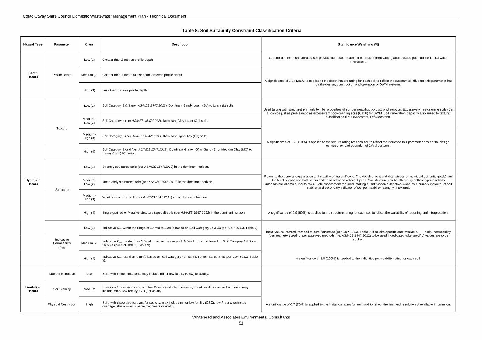
Colac Otway Shire Council Domestic Wastewater Management Plan - Technical Document
Whitehead and Associates Environmental Consultants 51
Table 8: Soil Suitability Constraint Classification Criteria
Hazard Type Parameter Class Description Significance Weighting (%)
Depth Hazard Profile Depth
Low (1) Greater than 2 metres profile depth Greater depths of unsaturated soil provide increased treatment of effluent (renovation) and reduced potential for lateral water movement.
Medium (2) Greater than 1 metre to less than 2 metres profile depth
A significance of 1.2 (120%) is applied to the depth hazard rating for each soil to reflect the substantial influence this parameter has on the design, construction and operation of DWM systems.
High (3) Less than 1 metre profile depth
Hydraulic Hazard
Texture
Low (1) Soil Category 2 & 3 (per AS/NZS 1547:2012). Dominant Sandy Loam (SL) to Loam (L) soils. Used (along with structure) primarily to infer properties of soil permeability, porosity and aeration. Excessively free-draining soils (Cat
1) can be just as problematic as excessively poor-draining soils (Cat 6) for DWM. Soil 'renovation' capacity also linked to textural classification (i.e. OM content, Fe/Al content). Medium -
Low (2) Soil Category 4 (per AS/NZS 1547:2012). Dominant Clay Loam (CL) soils.
Medium - High (3) Soil Category 5 (per AS/NZS 1547:2012). Dominant Light Clay (LC) soils.
A significance of 1.2 (120%) is applied to the texture rating for each soil to reflect the influence this parameter has on the design, construction and operation of DWM systems.
High (4) Soil Category 1 or 6 (per AS/NZS 1547:2012). Dominant Gravel (G) or Sand (S) or Medium Clay (MC) to Heavy Clay (HC) soils.
Structure
Low (1) Strongly structured soils (per AS/NZS 1547:2012) in the dominant horizon.
Refers to the general organisation and stability of 'natural' soils. The development and distinctness of individual soil units (peds) and the level of cohesion both within peds and between adjacent peds. Soil structure can be altered by anthropogenic activity
(mechanical, chemical inputs etc.). Field assessment required, making quantification subjective. Used as a primary indicator of soil stability and secondary indicator of soil permeability (along with texture).
Medium - Low (2) Moderately structured soils (per AS/NZS 1547:2012) in the dominant horizon.
Medium - High (3) Weakly structured soils (per AS/NZS 1547:2012) in the dominant horizon.
High (4) Single-grained or Massive structure (apedal) soils (per AS/NZS 1547:2012) in the dominant horizon. A significance of 0.9 (90%) is applied to the structure rating for each soil to reflect the variability of reporting and interpretation.
Indicative Permeability
(Ksat)
Low (1) Indicative Ksat within the range of 1.4m/d to 3.0m/d based on Soil Category 2b & 3a (per CoP 891.3, Table 9). Initial values inferred from soil texture / structure (per CoP 891.3, Table 9) if no site-specific data available. In-situ permeability
(permeameter) testing, per approved methods (i.e. AS/NZS 1547:2012) to be used if dedicated (site-specific) values are to be applied.
Medium (2) Indicative Ksat greater than 3.0m/d or within the range of 0.5m/d to 1.4m/d based on Soil Category 1 & 2a or 3b & 4a (per CoP 891.3, Table 9).
High (3) Indicative Ksat less than 0.5m/d based on Soil Category 4b, 4c, 5a, 5b, 5c, 6a, 6b & 6c (per CoP 891.3, Table 9). A significance of 1.0 (100%) is applied to the indicative permeability rating for each soil.
Limitation Hazard
Nutrient Retention Low Soils with minor limitations; may include minor low fertility (CEC) or acidity.
Soil Stability Medium Non-sodic/dispersive soils; with low P-sorb, restricted drainage, shrink swell or coarse fragments; may include minor low fertility (CEC) or acidity.
Physical Restriction High Soils with dispersiveness and/or sodicity; may include minor low fertility (CEC), low P-sorb, restricted drainage, shrink swell, coarse fragments or acidity. A significance of 0.7 (70%) is applied to the limitation rating for each soil to reflect the limit and resolution of available information.
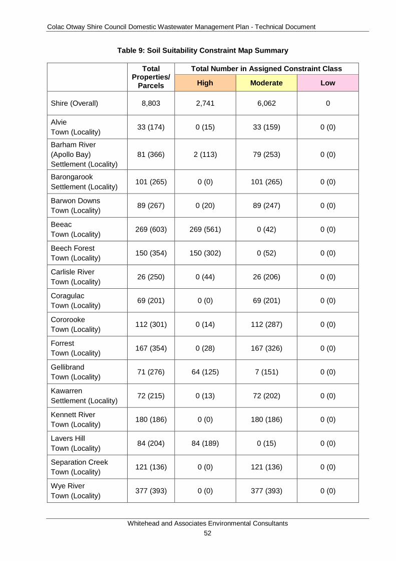
Colac Otway Shire Council Domestic Wastewater Management Plan - Technical Document
Whitehead and Associates Environmental Consultants 52
Table 9: Soil Suitability Constraint Map Summary
Total
Properties/Parcels
Total Number in Assigned Constraint Class
High Moderate Low
Shire (Overall) 8,803 2,741 6,062 0
Alvie Town (Locality)
33 (174) 0 (15) 33 (159) 0 (0)
Barham River (Apollo Bay) Settlement (Locality)
81 (366) 2 (113) 79 (253) 0 (0)
Barongarook Settlement (Locality)
101 (265) 0 (0) 101 (265) 0 (0)
Barwon Downs Town (Locality)
89 (267) 0 (20) 89 (247) 0 (0)
Beeac Town (Locality)
269 (603) 269 (561) 0 (42) 0 (0)
Beech Forest Town (Locality)
150 (354) 150 (302) 0 (52) 0 (0)
Carlisle River Town (Locality)
26 (250) 0 (44) 26 (206) 0 (0)
Coragulac Town (Locality)
69 (201) 0 (0) 69 (201) 0 (0)
Cororooke Town (Locality)
112 (301) 0 (14) 112 (287) 0 (0)
Forrest Town (Locality) 167 (354) 0 (28) 167 (326) 0 (0)
Gellibrand Town (Locality)
71 (276) 64 (125) 7 (151) 0 (0)
Kawarren Settlement (Locality)
72 (215) 0 (13) 72 (202) 0 (0)
Kennett River Town (Locality)
180 (186) 0 (0) 180 (186) 0 (0)
Lavers Hill Town (Locality)
84 (204) 84 (189) 0 (15) 0 (0)
Separation Creek Town (Locality)
121 (136) 0 (0) 121 (136) 0 (0)
Wye River Town (Locality)
377 (393) 0 (0) 377 (393) 0 (0)
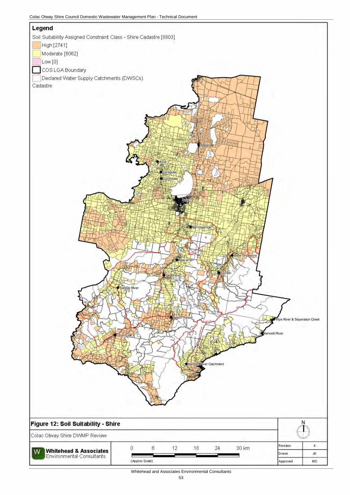
Colac Otway Shire Council Domestic Wastewater Management Plan - Technical Document
Whitehead and Associates Environmental Consultants 53
Figure 12: DWM Constraint Analysis - Soil Suitability - Shire
Colac Otway Shire Council Domestic Wastewater Management Plan - Technical Document
Whitehead and Associates Environmental Consultants 54
6.3 Sensitivity Overlay A sensitivity overlay for landslip hazard and depth to groundwater has been generated for use by Council in conjunction with the final Risk Assessment map to determine if any additional constraints may impact on sustainable DWM at any given location within the Shire. These sensitivity overlays will be applied at Council’s discretion upon reviewing any given property/parcel.
6.3.1 Landslip Hazard COS contains areas which are susceptible to landslip, including land throughout the Otway Ranges. The Otway Group, or Eumeralla Formation, is considered to be one of the most landslip prone geological units within the Shire. Landslips occur in both the rock and soil materials, even where the rock is not significantly weathered.
A number of geotechnical studies have been undertaken within COS by various public agencies, including ‘Landslip Risk Management in Colac Otway Shire’ and ‘Landslip Risk Management Related to Wastewater Disposal’ both undertaken by Dalhaus Environmental Geology Pty Ltd.
All land included in the Erosion Management Overlay (EMO1 - COS Planning Scheme) has been identified as having a sufficiently high risk of potential instability to warrant specific review of these risks prior to works as detailed in Schedule 1 to the EMO (COS Planning Scheme).
The landslip prone regions are shown in informative Figure A5, attached in Appendix A. The figure shows that the primary regions of landslip are found south of Lavers Hill, Beech Forest, Forrest and Gellibrand towns and along the coastline and hinterlands around the Apollo Bay, Kennett River, Wye River and Separation Creek towns. Council may request additional supporting documentation to be provided with regards to DWM in these regions.
6.3.2 Groundwater Depth If the soil is saturated and the groundwater depth is shallow, then there is a greater possibility of contaminating groundwater and increasing surface water runoff. This is particularly important in selecting the type of DWM system.
The depth to groundwater has direct implications on future development opportunities and can constrain the use of a DWM system. The location and type of land application system that can be installed on an individual property/parcel will be limited by the depth to groundwater at the site. If applied effluent moves into saturated soils, i.e. shallow groundwater located beneath a LAA, then potential contamination of the groundwater, aquifer and/or surface waters could occur. Saturated subsurface conditions are considered to be the most conducive to pathogen transport.
The current EPA Code of Practice states that a minimum depth of 1.5m must remain between the base of the land application system and the seasonal watertable. The greatest depth to groundwater from the natural ground surface would be required for trenches and beds, which are generally built to 600mm depth. Therefore, the minimum required depth to groundwater from the natural ground surface would be 2.1m. If this buffer cannot be maintained, a detailed DWM system design would be required. This calculated minimum depth to groundwater vertical setback distance is conservative; however, soil type would be the defining characteristic. For example, if the soil beneath the base of the LAA is sand, then the associated hydraulic conductivity would be high, with treated effluent reaching the groundwater table at a much quicker rate than if the soil was clay. Therefore, site specific DWM design is required in regions
Colac Otway Shire Council Domestic Wastewater Management Plan - Technical Document
Whitehead and Associates Environmental Consultants 55
where the depth to groundwater may be an issue, and the appropriateness of the required vertical setback distance to groundwater will need to be assessed.
Groundwater depth within the Shire was inferred from the groundwater bore data from the WMIS Database Interface as managed by DELWP; this is the same dataset used for the proximity to groundwater bores constraint analysis. A total of 294 groundwater bores, located within and around the vicinity of the Shire based on the WMIS DEPI data, were used in the depth to groundwater analysis. The depth of groundwater from the natural surface was time-series monitored for each of these bores as part of the State Observation Bore Network (SOBN). The average reduced water level of the time-series data for the groundwater depth was assigned to each bore. The groundwater bores and associated depths to groundwater were then spatially mapped as point data using GIS. The point data was gridded with no vertical exaggeration (maximum cell size of 20m) to create a Digital Elevation Model (DEM). The groundwater depths are summarised along a thematic colour gradient from surface water (negative values) (deep blue) to 245m (red), with an average depth of 21.5m. Gridded groundwater depth data was derived from the DEM and combined with the cadastre data set for the centroid of each property/parcel. This interpolates an average depth to groundwater for each property/parcel within the Shire which is covered by the extent of the DEM.
The following criteria were used to determine the DWM constraint classification for the depth to groundwater (based on the centroid of each property/parcel):
• Non-Compliant (high risk): properties/parcels that have an average groundwater depth less than the minimum vertical separation distance of 2.1m as stipulated by the current EPA Code of Practice; and
• Compliant (low risk): properties/parcels that have an average groundwater depth more than the minimum vertical separation distance of 2.1m as stipulated by the current EPA Code of Practice.
The resultant groundwater depth and groundwater depth compliance maps are attached as informative Figures A6 and A7, respectively, in Appendix A. The depth to groundwater compliance mapping showed that there were 4,542 compliant and 1,496 non-compliant properties/parcels within COS based on available data.
Due to the limited number of groundwater bores with water level information, there are regions within the Shire that were not able to be included in the analysis, particularly in the southern half of the Shire. There were properties/parcels throughout the Shire, primarily in the southern region, that was not covered by the DEM and were excluded from the depth to groundwater analysis due to lack of data. These are shown as white in the respective map. Due to lack of available data, the depth to groundwater compliance is to be used for informative purposes only and site specific investigations will be necessary to determine the depth of groundwater in the regions with no available data or for those properties/parcels that are non-compliant.
For properties/parcels constrained by groundwater depth (shallow groundwater), it might be possible to mitigate this constraint by:
• Secondary treatment with an AWTS or sand filter; or
• Increasing separation distance between point of land application and watertable by constructing a raised bed or sand mound.
Colac Otway Shire Council Domestic Wastewater Management Plan - Technical Document
Whitehead and Associates Environmental Consultants 56
6.3.3 Vegetation The National Parks and State Forests within COS have also been mapped and are presented as an informative map as Figure A7 in Appendix A. The Otway Ranges within the DWSCs is dominated by protected vegetated regions, which are also extensive along the Great Ocean Road extending into the north of the Apollo Bay, Wye River and Separation Creek localities. Great Otway National Park and Otway Forest Park form the primary classified vegetative areas within this region. The Otway Forest Park includes the mountain and foothill forest of the northern fall of the Otway Ranges, adjacent to the Great Otway National Park. The northern region of COS includes protected lakes of the Western Volcanic Plains.
6.4 Risk Assessment Summary It is evident that variability in constraint exists between the targeted localities and towns/settlements within the Shire. Further detailed studies into the performance of existing on-site DWM systems within each of the targeted unsewered localities and towns/settlements is recommended to verify the findings of this broad-scale risk assessment, to provide a more detailed study on maximum property/parcel development density and hence minimum lot size in proposed development areas. This will aid Council in ensuring future development will not adversely impact environmental and public health. The Sensitivity Analysis, which consolidates the individual constraints, is detailed in Section 4.1 of the Operational Plan.
Colac Otway Shire Council Domestic Wastewater Management Plan - Technical Document
Whitehead and Associates Environmental Consultants 57
7 Land Application System Sizing Tables (Water Balance) 7.1 Overview Water balance modelling was undertaken to determine the minimum footprint areas for a broad range of effluent land application systems that could be used in unsewered properties in the Shire. All six of the AS1547:2012 soil categories were used in the modelling, for three household sizes (based on number of bedrooms and likely maximum occupancy rate, for domestic dwellings). The results are provided in the System Sizing Tables (in the Locality Reports in Appendix B), which summarise the minimum basal (or ‘wetted’) area and the likely minimum total footprint area (including minimum spacing for trenches and beds) for different systems. The Sizing Tables are suitable for designing land application systems for Low and Moderate Risk properties only.
It is noted that most localities will only have two or three soil types, and that the system sizing’s provided for the other soil types are irrelevant for that location (unless a significant amount of topsoil is imported for the construction of the land application system, which is not common).
7.2 Water Balance Methodology A water balance is a means of incorporating the impact of rainfall, evapotranspiration and plant and soil moisture fluxes into the design of effluent land application systems (from trenches to irrigation systems). Water balance is a critical factor in the effective design and operation of effluent land application systems. This is particularly relevant for the higher rainfall areas in the southern half of the Shire.
A simplistic water balance is expressed by the following equation:
On the left hand side of the equation are the water INPUTS, factors that add to the moisture within an irrigation field. On the right hand side of the equation are the water LOSSES, factors that reduce the moisture content within an irrigation field. For a land application area to be balanced hydraulically the INPUTS should be equal to or less than the LOSSES, otherwise hydraulic overloading and failure may result if the inherent moisture storage capacity of the irrigation field is subsequently exceeded.
Rainfall data can be obtained from the Bureau of Meteorology and commonly water balances are undertaken using conservative monthly rainfall data for a local weather station. Pan evaporation (Class A Pan) is less readily available, and usually is only available for selected weather stations. Evapotranspiration is the combination of evaporation and transpiration of moisture from the soil through the open pores in the leaves of plants. Evapotranspiration rates vary with changes to soil and air moisture as well as season, but can be estimated by applying appropriate monthly crop factors to pan evaporation data.
Percolation is equivalent to the rate of deep drainage of both rainfall and applied effluent through the soil and is controlled mainly by soil properties, but also in part by slope and other factors. The runoff factor allows for the fact that not all rainfall that falls on a ground surface will actually infiltrate the irrigation field and so contribute to soil moisture. During periods of high rainfall, the soil becomes saturated and excess rainfall runs off as it cannot percolate into the soil.
Precipitation + Applied Effluent = Evapotranspiration + Percolation + Runoff
Colac Otway Shire Council Domestic Wastewater Management Plan - Technical Document
Whitehead and Associates Environmental Consultants 58
If all factors in the water balance are expressed in terms of millimetres (mm) per month, then it is possible to solve the equation to determine a minimum land application area (footprint) such that the LOSSES match or exceed the INPUTS. This is usually done using pre-prepared spreadsheets to simplify the numerous calculations involved in running the balance for each month of the year.
The water balance methodology used for the Sizing Tables is the same as that described in the MAV Land Capability Assessment Framework (2014) and the specific inputs are discussed below.
7.3 Water Balance Inputs 7.3.1 Daily Wastewater Load The daily wastewater load is the product of the design occupancy rate and the wastewater generation in L/person/day.
The current EPA Code of Practice specifies that the design occupancy rate is the number of bedrooms (including any rooms that could be used as a bedroom, such as a study or library) plus one. For example, a four bedroom home is expected to accommodate up to 5 persons in the normal course of events (this does not include accommodation, businesses or holiday homes). This takes into account the future potential occupancy, not just the current occupancy (which may be much smaller).
Table 4 of the EPA Code of Practice (2013) specifies a wastewater generation rate of 180L/person/day for households with standard water fixtures. The water balance uses this figure. However, where it can be demonstrated that full-reduction fixtures have been, or will be, installed in the household and will remain in place, then a design loading rate of 150L/person/day, in accordance with AS1547:2012 can be adopted for a site-specific DWM design. Alternatively if tank water is the only water source onsite, then a design loading rate of 120L/person/day, can be used in accordance with AS1547:2012, and the results in the System Sizing Tables will not apply.
The design wastewater loads used in water balance modelling are shown in Table 10 below.
Table 10: Design Wastewater Loads for Water Balance Modelling
No. Bedrooms Design Occupancy L/person/day L/household/day 1-3 4 180 720 4 5 180 900 5 6 180 1,080
7.3.2 Climate Data For this project, interpolated rainfall and evapotranspiration data for each unsewered locality has been obtained from SILO and BoM databases, as discussed in Section 6.2.2 above. 70th percentile rainfall and average evapotranspiration data were used to create unique water balances for each system type for each locality. The data point closest to the town/settlement was used for the water balance, and in some cases more than one town/settlement shares the same climate data point due to proximity to that data point.
7.3.3 Runoff Factor Conservative annual runoff factors of 10% (90% infiltration of rainfall) have been adopted for soil absorption systems (e.g. trench, bed etc.) and 20% (80% infiltration) for drip and spray
Colac Otway Shire Council Domestic Wastewater Management Plan - Technical Document
Whitehead and Associates Environmental Consultants 59
irrigation systems in the Shire, which is likely to be an underestimate for the higher rainfall areas on and around the Otways.
7.3.4 Soil Type and Design Loading Rate or Design Irrigation Rate (DLR or DIR) The DLRs and DIRs for the commonly used EPA-accepted methods of land application of effluent (as listed in Appendix A, Table 9, of the EPA Code of Practice, 2013) were used as the basis of water balance modelling and the sizing of the land application areas for all systems. All listed systems except for mounds were modelled, as mounds require a site-specific design which accounts for site factors (including, but not limited to, ground slope). For simplicity, every soil category (and subcategories depending on soil structure), have been modelled, regardless of whether they are observed in the locality. The DLR or DIR should be selected for the most limiting soil layer (usually the heavier-textured subsoil horizons). Where data was absent from the current EPA Code of Practice, average values were selected from AS1547:2012 (Table 5.2). For instance, the current EPA Code of Practice does not specify DLRs for absorption or evapotranspiration (ETA) beds for gravels, sands or weakly structured sandy loams, but acknowledges that these systems may be appropriate if the soil does not have a high perched or seasonal groundwater table.
7.4 Implications for High Rainfall Areas The water balance is highly sensitive to the Design Loading Rate (DLR) or Design Irrigation Rate (DIR) selected. The DLR and DIR are considered to be conservative or ‘safe’ deep drainage percolation rates for land application systems that are sustainable for the long term. However, deep drainage percolation in DWM land application areas is not widely understood and the high variability of soil dynamics across regions means that a ‘one size fits all’ approach may not be the most appropriate method for designing a land application system for a particular site.
If the selected DLR or DIR, taken from the EPA Code of Practice, 2013 (Appendix A: Table 9), is low due to heavy-textured soils and the site is in a high rainfall region, then the required minimum land application area is proportionately large. This can pose difficulties for design and installation, particularly for systems that use gravity dosing (which is far less effective for large systems compared to pumped dosing).
Some areas within the Shire feature areas of particularly high rainfall and low winter evapotranspiration, which presents a case whereby the water balance, is unresolvable and therefore cannot produce consequential data. For these areas, Lavers Hill, Beech Forest, and the Barham River catchment (known as ‘Paradise’), the water balance method as described above cannot be used to predict the minimum required area for effluent land application, and a site-specific, detailed system design is required. As a result of the water balance, the majority of properties in these localities are likely to be rated as High or Very High Risk, and therefore the Sizing Tables are not applicable. There may be properties/parcels in high rainfall areas that also have an unresolvable water balance in addition to the above mentioned localities.
The Bureau of Meteorology (BoM) website shows five rainfall stations on the Otway Ridge; Lavers Hill, Weeaproinah, Barramunga, Beech Forest and Wyelangta, with the latter two still actively recording rainfall. 70th percentile monthly rainfall from the active station that is closest to the Otway Ridge location being assessed should be used in any water balance; e.g. for Lavers Hill, the 70th percentile monthly rainfall from the Wyelangta BoM rainfall station should be used. The 70th percentile monthly rainfall from the Wyelangta and Beech Forest BoM rainfall stations is tabulated in Appendix C.
Colac Otway Shire Council Domestic Wastewater Management Plan - Technical Document
Whitehead and Associates Environmental Consultants 60
Furthermore, the water balance and prescribed DLRs and DIRs do not take into consideration the possibility that the soil and/or bedrock in some high rainfall areas may have a natural permeability that is higher than that assumed from its textural category. In such instances, the DLR or DIR could be sustainably increased, thereby allowing for a smaller system footprint. A site-specific water balance would require detailed soil testing (including constant-head permeameter testing) to clearly demonstrate that the soil can sustainably accommodate a higher effluent loading, year-round. This approach is suitable for properties that are rated as Low, Moderate or High Risk.
In these high rainfall areas, site-specific design to select and size an appropriate DWM system and effluent disposal method is required to ensure that DWM is sustainable with no off-lot discharge. Innovative designs may be required and overarching measures to assist in managing the wastewater in these regions may include minimising wastewater generation, increasing reuse and increasing the land application footprint. It should be noted that there may be cases in which an appropriate solution cannot be devised or in which costs are prohibitive.
7.5 Footprint Area of Land Application Systems The size of a land application system depends not only on the volume of the effluent to be applied, the quality of the soil and on local rainfall, but also on how the system is laid out and on the spacing of components (e.g. trenches) and the width of mandatory setbacks.
In a subsurface irrigation system, the drip-lines are often closely spaced and the land may be considered to have an even loading. Therefore, the total land application area is the required area as specified by the water balance (plus any setbacks which must be maintained). Irrigation systems can be designed to best fit the most suitable area, provided that the pump is capable of delivering effluent evenly throughout the entire system.
For absorption and ETA trenches and beds, wick trenches and Low Pressure Effluent Distribution (LPED) systems, a minimum spacing between trenches or beds must be observed to prevent overloading of the soil between them. The current EPA Code of Practice or AS1547:2012 specifies minimum spacing’s, which have been used to estimate a typical footprint area of the system, on the assumption that the longest acceptable trench or bed length has been used. These values are provided in the individual model spreadsheets for each system type. It is highlighted that the ‘typical footprint’ is indicative only, and is likely to represent the minimum footprint for a well-laid out system. The final area must be determined by the system designer/installer as part of the final DWM design (for all risk category properties).
Colac Otway Shire Council Domestic Wastewater Management Plan - Technical Document
Whitehead and Associates Environmental Consultants 61
8 Sub-catchment Analysis The Minister for Water’s (2012) Guidelines for planning permit applications in potable water supply catchments specify that, to avoid the blanket application of a 1 in 40 hectare dwelling density in DWSCs, a DWMP must include consideration of the broader cumulative impact of DWM systems within a catchment. Aggregated ‘cumulative’ risk is area dependant, therefore it is important to delineate manageable areas for investigation and analysis. The DWSCs were therefore divided into smaller ‘sub-catchments’ so that the cumulative risk could be identified and to assist in prioritising further assessment and management resources. Sub-catchments are delineated based on areas of concern; whether that refers to offtake points, water quality sampling points or towns/settlements. The aim is to identify areas of concern that may pose a potential impact on water quality.
The sub-catchments were delineated using the TauDEM Sub-catchment Delineation tool in QGIS™. The Digital Elevation Model (DEM) developed in Section 6.2.5 and Water Corporation identified offtake and discharge points were used to inform the delineation of the sub-catchment boundaries. There are 9 identified Barwon Water offtakes, 5 identified Wannon Water offtakes and 10 identified discharge points. The Barwon Downs Wellfield Intake offtake points (seven in total) that refer to groundwater and multiple North Otway Wannon Water offtake points that are located in the same locality are not included in the sub-catchment analysis. For the purposes of this analysis, a sub-catchment is an area of terrain with one single outflow point. The residual regions were subdivided into a number of larger sub-catchments based on their discharge points.
Sub-catchment analysis can be applied at a variable scale. In addition to delineating the sub-catchments based on offtake and discharge points, smaller sub-catchments were delineated based on the town/settlement boundaries for the targeted unsewered towns/settlements located within the DWSC. The aim is to prioritise both the towns/settlements and sub-catchments within the DWSCs and to determine the relative contribution of risk of the town/settlement development within the larger sub-catchment.
Figure 13 shows the delineated sub-catchments and towns/settlements within the DWSC and the relative offtake and discharge points. The sub-catchment analysis resulted in the delineation of 24 individual sub-catchments, with 13 of these sub-catchments delineated based on offtake points. There were seven town/settlement sub-catchments identified. It is important to ensure that a high level of environmental health is maintained within these 13 sub-catchments in order to ensure that the drinking water supply is protected.
Section 4.4 of the Operational Plan details the prioritisation of both sub-catchments and towns/settlements based on cumulative Sensitivity Ratings. Figure 14 outlines the Sensitivity Rating mapping for the DWSCs.
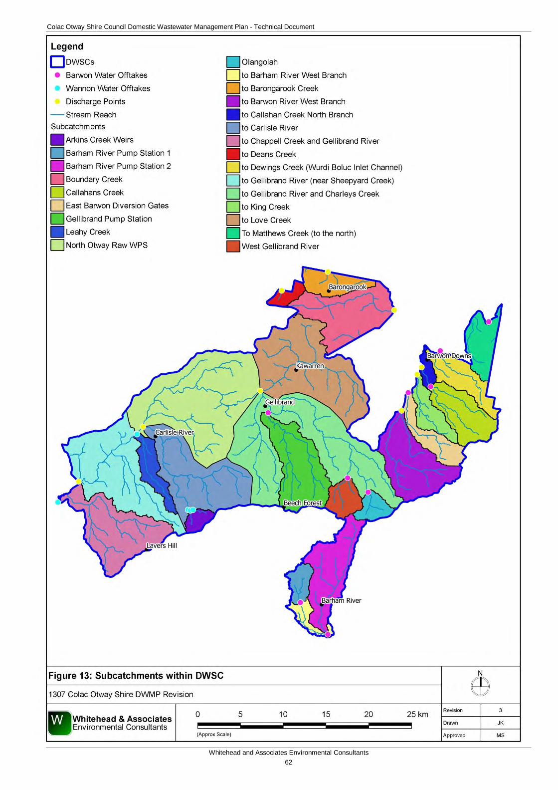
Colac Otway Shire Council Domestic Wastewater Management Plan - Technical Document
Whitehead and Associates Environmental Consultants 62
Figure 13: Delineated Sub-catchments within DWSCs
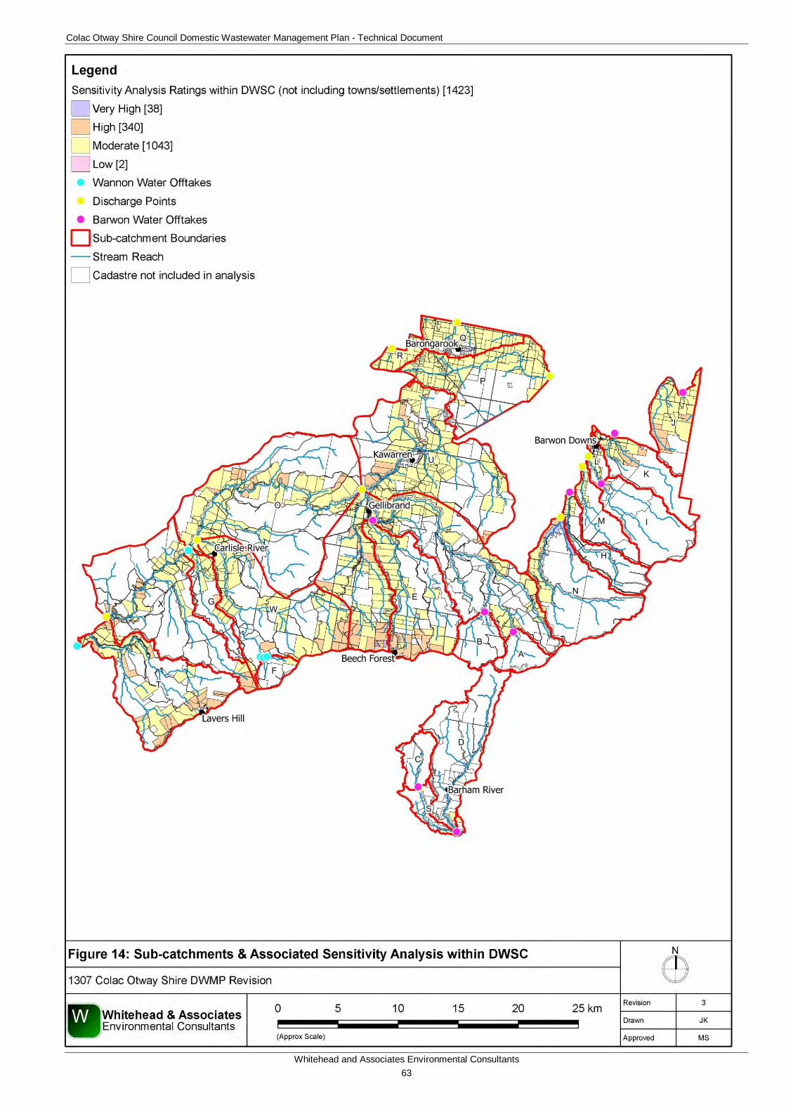
Colac Otway Shire Council Domestic Wastewater Management Plan - Technical Document
Whitehead and Associates Environmental Consultants 63
Figure 14: Sub-catchment and Associated Sensitivity Analysis within DWSCs
Colac Otway Shire Council Domestic Wastewater Management Plan - Technical Document
Whitehead and Associates Environmental Consultants 64
9 Glossary of Terms Term Definition
Aerobic treatment Biological treatment processes that occur in the presence of oxygen (i.e. aerobic bacteria digest wastewater contaminants). Aerobic bacteria are organisms that require oxygen to survive and grow.
Anaerobic treatment Biological treatment processes that occur in the absence of oxygen.
Blackwater Wastewater grossly contaminated with faeces (i.e. from a toilet).
Desludging Removal of the semi solid waste from a tank.
Effluent Water discharged from a treatment plant.
Evapotranspiration Transfer of water from the soil to the atmosphere through evaporation and plant transpiration. Calculated using the FAO Penman-Monteith method to derive (ET0).
Organic Matter Material that comes from the tissues of organisms (plants, animals, or microorganisms) that are currently or were once living.
Greywater Wastewater from showers, baths, sinks, washing machines, dish washers.
Hardpan A hardened, compacted and/or cemented horizon.
Locality The broader locality surrounding a town (place name within mapped boundaries).
Non-Potable Water not suitable for human consumption.
Parcel
The smallest unit of land able to be transferred within Victoria's cadastral system, usually having one proprietor or owner (land.vic.gov.au). For the purposes of this DWMP, parcel and lot are given to have the same meaning.
Peds An aggregate of soil particles.
Permeability The ability of the soil to allow water to pass through.
P-sorb Phosphorus adsorption capacity of soil.
Property Land under common occupation (land.vic.gov.au). May include multiple parcels.
Sensitivity The ‘likely’ consequence of off-site (DWM) impacts based on the cumulative effect of individual property/parcel constraints (soil suitability, slope, useable lot area, climate and location) and variables affecting the specific land capability and associated limitations of the property/parcel to sustainably manage wastewater in compliance with SEPP objectives.
Settlement An area of residential development within the Rural Living Zone (Barongarook and Kawarren) or Rural Conservation Zone (Barham River).
Sewage Solid and liquid wastewater conveyed through sewers.
Sewerage A system of sewers.
Town The town servicing a locality, which is predominantly zoned Township Zone. It contains both residential and commercial development.
Colac Otway Shire Council Domestic Wastewater Management Plan - Technical Document
Whitehead and Associates Environmental Consultants 65
10 References Australian Bureau of Statistics (2011). Population and Dwelling Statistics – Colac Otway Shire.
Centre for Environmental Training (2012). Land Capability Assessment for On-site Wastewater Management Systems Course.
Department of Primary Industries. Declared Water Supply Catchments in Victoria Catchment Management Areas. Retrieved from: http://vro.dpi.vic.gov.au/dpi/vro/vrosite.nsf/pages/catchment, accessed November 2012.
Department of Primary Industries (2008). Geomorphological Units for Corangamite CMA. Victoria Resources Online.
Department of Primary Industries (2012). Geological Units 1:250,000. GeoSciences Victoria. Earth Resources.
Department of Sustainability and Environment (2012). Planning Permit Applications in Open, Potable Water Supply Catchment Areas. Victoria.
Environment Protection Authority (1970). Environment Protection Act.
Environmental Protection Authority (1997). State Environment Protection Policy (Groundwaters of Victoria).
Environment Protection Authority (1996). Publication 451 Onsite Domestic Wastewater Management.
Environment Protection Authority (2002). Guidelines for Aerated On-site Wastewater Treatment Systems.
Environment Protection Authority (2003). State Environment Protection Policy (Waters of Victoria).
Environment Protection Authority (2003a). Publication 746.1 Land Capability Assessment for Onsite Domestic Wastewater Management.
Environment Protection Authority (2013). Publication 891.3. Code of Practice – Onsite Wastewater Management.
Municipal Association of Victoria (2003). Domestic Wastewater Management: A Planning Guide for Local Government.
Municipal Association of Victoria (2014). Model Land Capability Assessment Report.
Robinson et al. (Department of Primary Industries). (2003). A Land Resource Assessment of the Corangamite Region. Primary Industries Research Victoria. Bendigo.
Rowan J., Russell L., Ransom S. & Rees D. (Ed). (2000). Land Systems of Victoria. Ed 3:2. Centre for Land Protection Research. Technical Report 56.
SKM (2014) Wye River and Separation Creek: Quantitative Microbial Risk Assessment and Ecological Risk Assessment, VW07110.
Standards Australia/Standards New Zealand (2003). AS/NZS 3500 Plumbing and Drainage, Part 1: Water Services and Part 2: Sanitary Plumbing and Drainage.
Standards Australia/Standards New Zealand (2012). AS/NZS 1547:2012 On-site Domestic-Wastewater Management.

Colac Otway Shire Council Domestic Wastewater Management Plan - Technical Document
Whitehead and Associates Environmental Consultants 66
Wannon Water (2015). Property Management Plan Guide, (updated) July 2015.
Wannon Water (2015). Planning Permit Advice to Applicants, October 2015.

Colac Otway Shire Council Domestic Wastewater Management Plan - Technical Document
Whitehead and Associates Environmental Consultants 67
Appendix A
Informative Maps
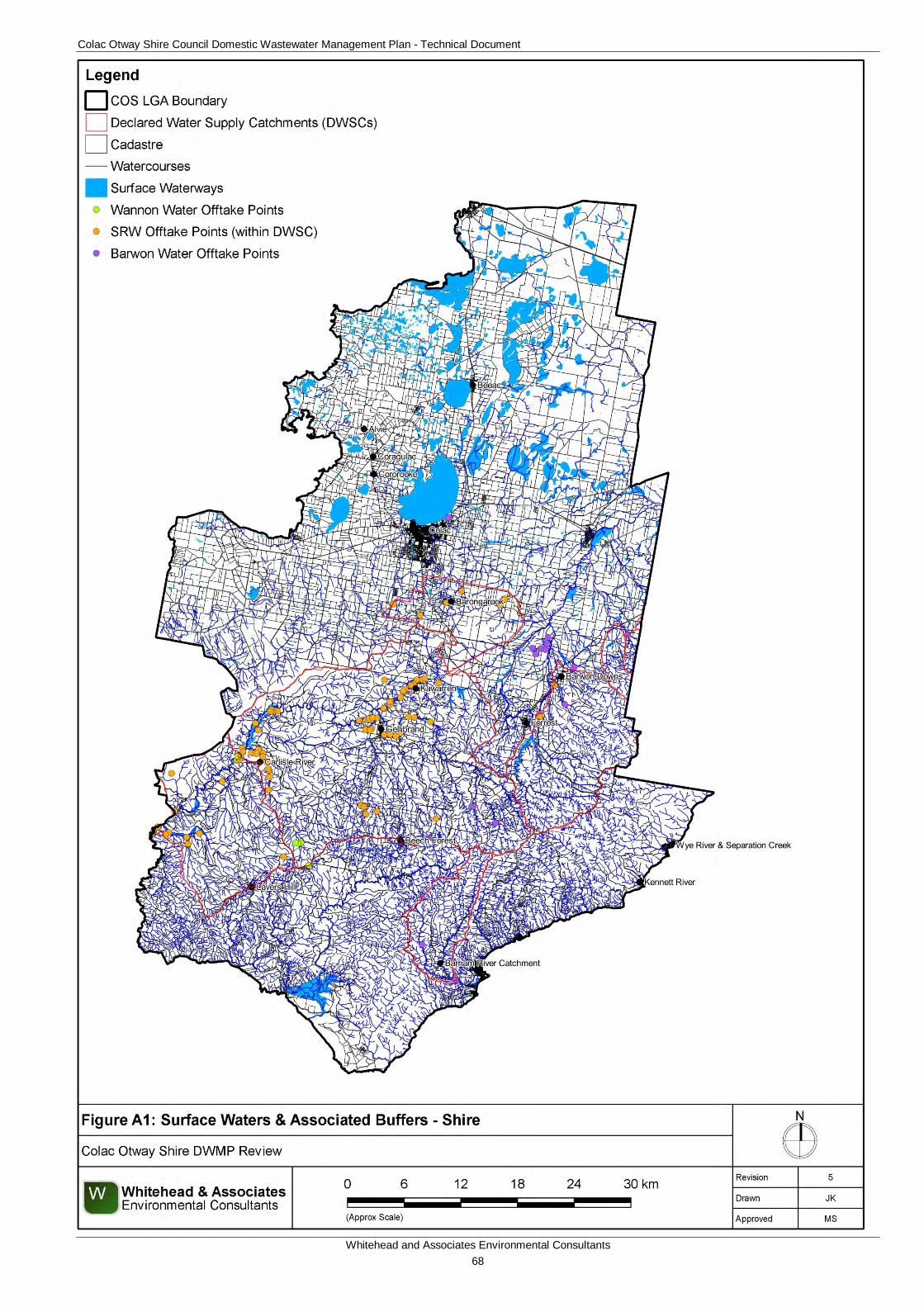
Colac Otway Shire Council Domestic Wastewater Management Plan - Technical Document
Whitehead and Associates Environmental Consultants 68
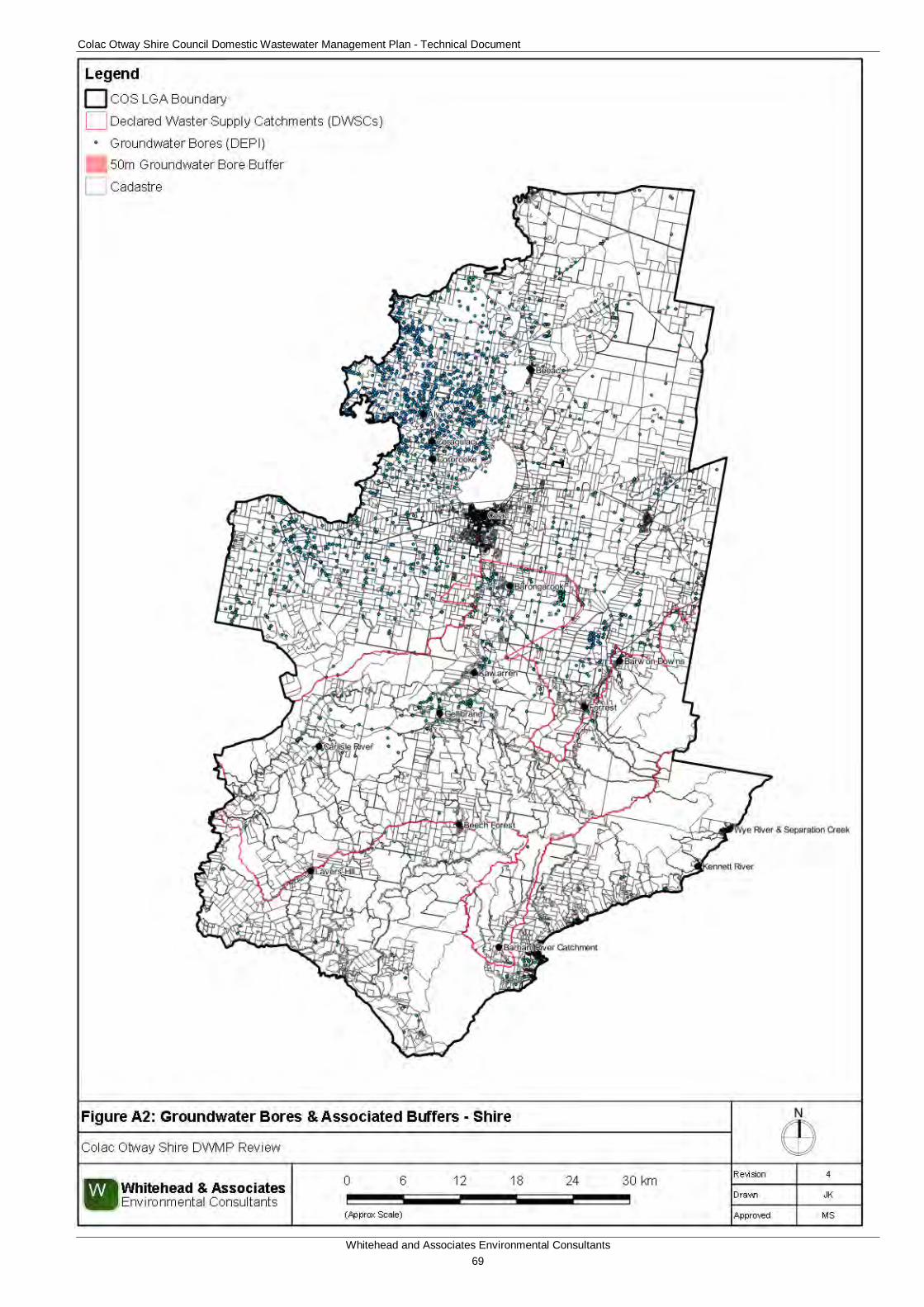
Colac Otway Shire Council Domestic Wastewater Management Plan - Technical Document
Whitehead and Associates Environmental Consultants 69
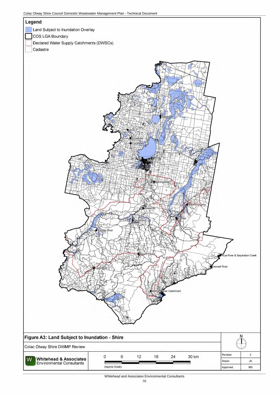
Colac Otway Shire Council Domestic Wastewater Management Plan - Technical Document
Whitehead and Associates Environmental Consultants 70
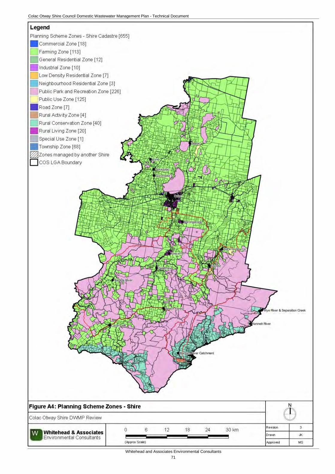
Colac Otway Shire Council Domestic Wastewater Management Plan - Technical Document
Whitehead and Associates Environmental Consultants 71
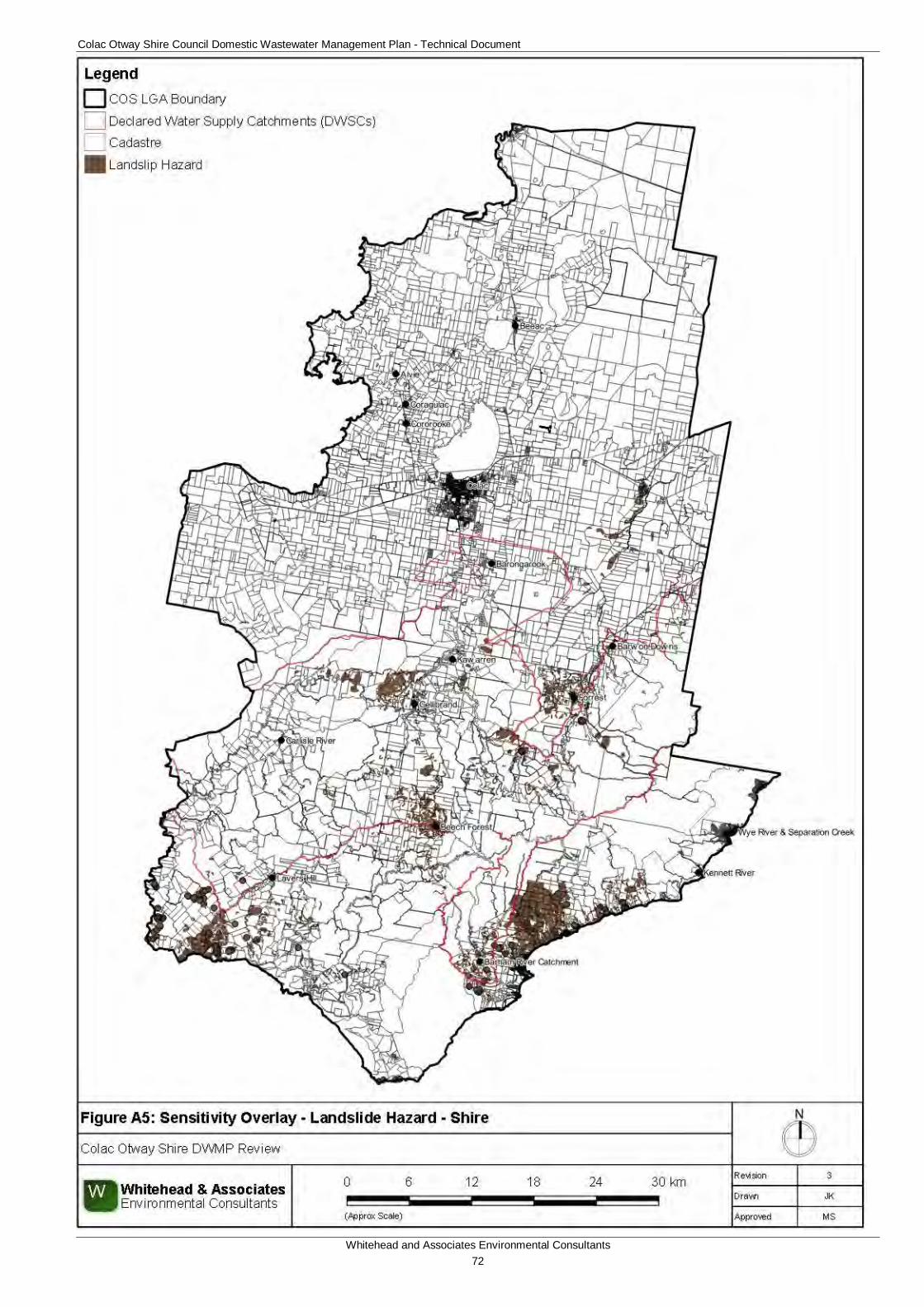
Colac Otway Shire Council Domestic Wastewater Management Plan - Technical Document
Whitehead and Associates Environmental Consultants 72
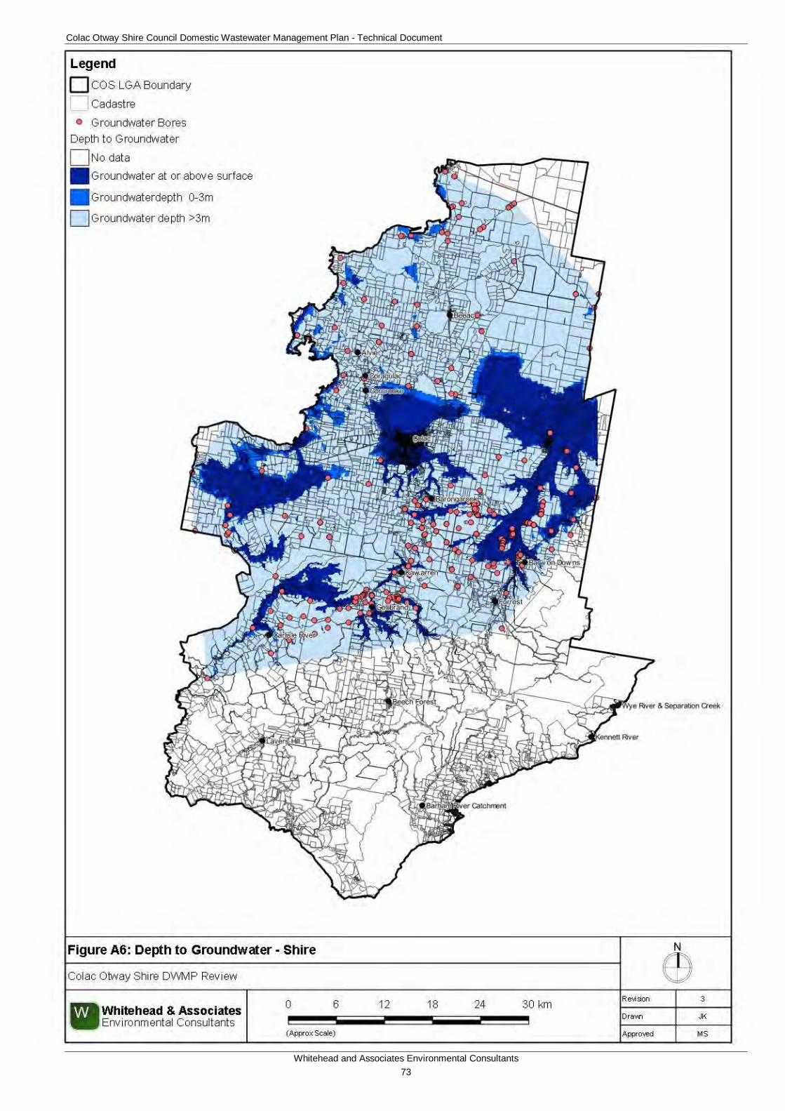
Colac Otway Shire Council Domestic Wastewater Management Plan - Technical Document
Whitehead and Associates Environmental Consultants 73
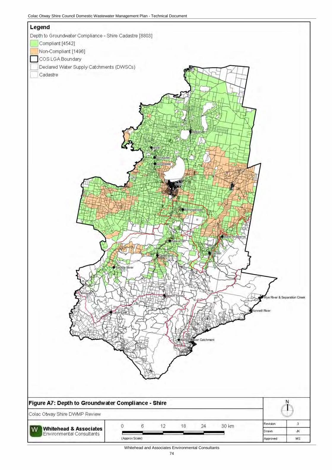
Colac Otway Shire Council Domestic Wastewater Management Plan - Technical Document
Whitehead and Associates Environmental Consultants 74
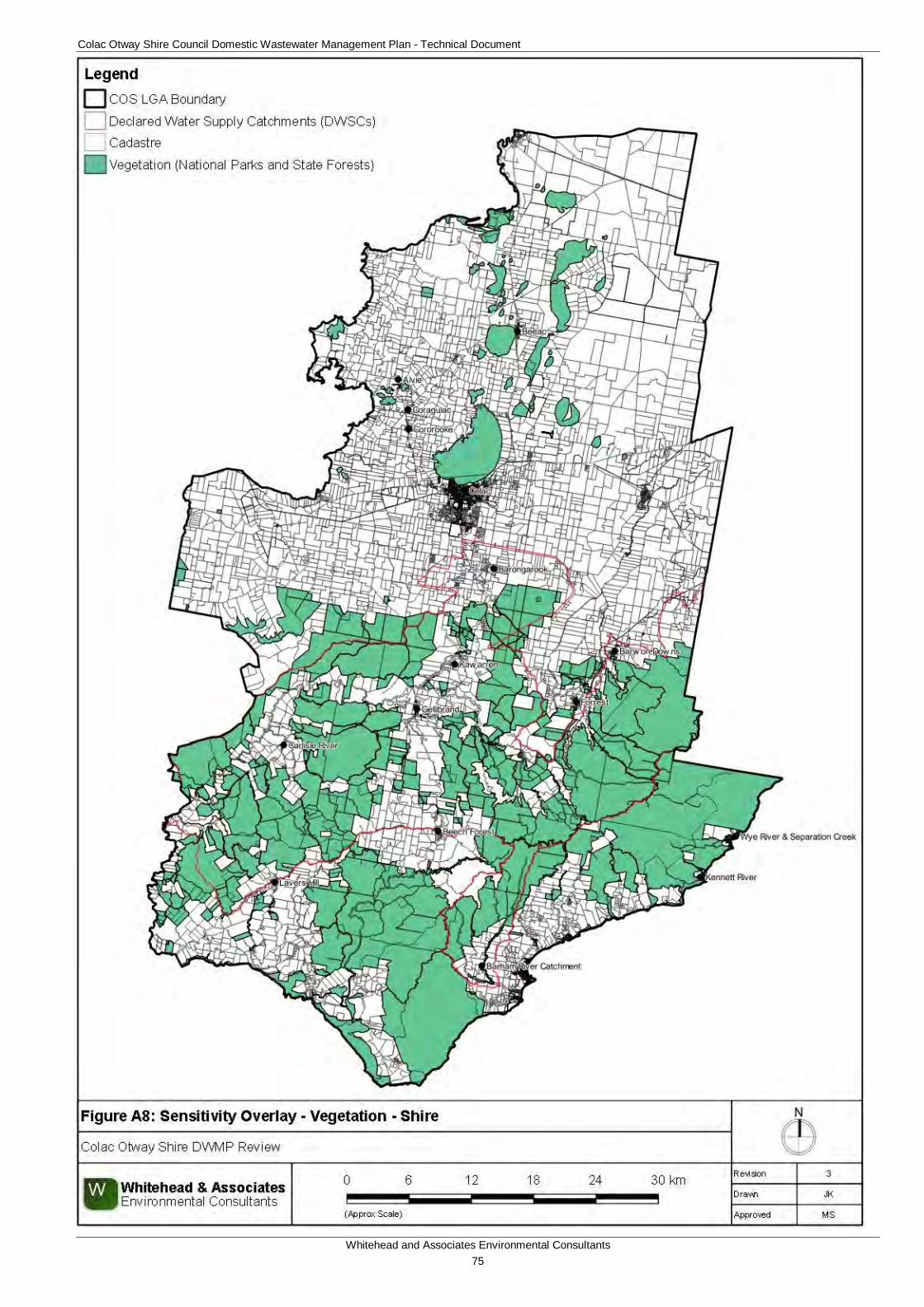
Colac Otway Shire Council Domestic Wastewater Management Plan - Technical Document
Whitehead and Associates Environmental Consultants 75
Colac Otway Shire Council Domestic Wastewater Management Plan - Technical Document
Whitehead and Associates Environmental Consultants 76
Appendix B
Locality Reports
Note: words have the following meanings in the DWMP (refer to glossary for further definition):
‘Town’ means the developed area/town which services the wider locality. ‘Towns’, which contain both residential and commercial development, are predominantly zoned Township zone.
‘Settlement’ refers to residential areas in Barham River, Barongarook and Kawarren, which are in the Rural Living Zone and Rural Conservation Zone.
‘Locality’ means the wider geographical area, inclusive of the town/settlement.
The white cadastre regions shown on the locality and town/settlement Sensitivity Rating maps refers to regions excluded from the study. Refer to Section 5 for more detail.
Colac Otway Shire Council Domestic Wastewater Management Plan - Technical Document
Whitehead and Associates Environmental Consultants 77
A. Alvie Locality Report 1a. Introduction Alvie is a rural locality located approximately 12km northwest of Colac on the western side of Lake Corangamite within the Western Volcanic Plain landscape and Red Rock region. Alvie lies at the foot of the Red Rock Scenic Reserve, an old scoria formation that formed due to violent volcanic eruptions, which is a popular tourist attraction.
There are approximately 174 and 33 unsewered properties/parcels located within the Alvie locality and town respectively, with 28 DWM system permits that have been inspected to date by COS. The current DWM permits and their associated treatment system and LAA method within the Alvie locality are summarised as follows:
• 2 AWTS (1 subsurface irrigation, 1 unknown);
• 20 septic tanks (6 trenches and 14 unknown);
• 1 worm farm (1 subsurface irrigation); and
• 5 unknown (2 trenches and 3 unknown).
No site investigations were conducted within the Alvie locality as part of the 2014 field assessments; however, soil investigations were conducted to confirm the soil type.
2a. Background Documentation Refer to the following documents for additional detail specifically regarding the locality:
• Red Rock Region Community Infrastructure Plan (September, 2013);
• COS Planning Scheme; and
• Rural Living Strategy (2011)
3a. Summary of Constraints to DWM Characteristic Description
Climate Zone Zone 2.
Surface waterways & catchments
Alvie contains a number of lakes, predominantly in the region to the south of the locality, that have formed within the Western Volcanic Plains; including Lake Coragulac (southeast near town), Lake Wernwrap, Lake Purdiguluc and Lake Gnalinegurk.
Groundwater Proximity to groundwater bores: significant throughout the locality with a high density of groundwater bores.
Land subject to inundation
To the south of the town around the lakes.
Useable lot area
Town (Locality)
High: 12 (23)
Moderate: 11 (27)
Colac Otway Shire Council Domestic Wastewater Management Plan - Technical Document
Whitehead and Associates Environmental Consultants 78
Characteristic Description
Low: 10 (111)
Compliant: 0 (13)
Minimum lot size compliance with Planning Scheme Zoning
The town is predominantly zoned as Township, with some Public Use Zone. Land in the wider locality area is predominantly in the Farming Zone, with land associated with the lakes in the Public Conservation and Resource Zone.
Compliancy is variable throughout the locality, with the majority of the town compliant.
Compliant: 28 (51)
Non-compliant: 5 (123)
Slope
Town (Locality)
High: 1 (18) (higher towards Lake Coragulac)
Moderate: 7 (15)
Low: 25 (141)
Geology Northwest region – unnamed stony rises of Newer Volcanic Group;
Town – unnamed phreatomagmatic deposits (tuff rings) of Newer Volcanic Group;
Eastern and southern regions – unnamed scoria deposits (scoria cones and agglutinated spatter rims) of Newer Volcanic Group; and
Some unnamed non-marine swamp, lake and estuarine deposits.
Soil suitability
Town (Locality)
High: 0 (15)
Moderate: 33 (159)
Low: 0 (0)
The town consists of soil landscape unit ‘101’ (moderate rating) which forms in the undulating low hills of the Western Volcanic Plains and consists of friable mottled black texture contrast soil and neutral black gradational soils to depths less than 1.5m. The soils consist of moderately structured clay loam over strongly structured medium clay to heavy clay. Limitations include restricted drainage.
The western and surrounding regions of the locality consists of soil landscape unit ‘114’ (moderate rating) which forms in the undulating basalt plains and stony rises and consists of gradational and friable mottled textured contrast soils to depths of less than 1.5m. The soils consist of strongly structured clay loam over strongly structured medium clay.
There are some landform depressions to the north of the town.
Colac Otway Shire Council Domestic Wastewater Management Plan - Technical Document
Whitehead and Associates Environmental Consultants 79
Characteristic Description
Sensitivity Overlay
Depth to Groundwater Compliance: all compliant.
Landslip: Nil.
Vegetation: Red Rock Scenic Reserve and lakes to the south (Coragulac, Werowrap, Corangamite, and Gnalinegurk).
Sensitivity Analysis Rating
Town (Locality)
Very High: 0 (0)
High: 3 (8)
Moderate: 22 (81)
Low: 8 (85)
4a. Sensitivity Analysis (Maps)
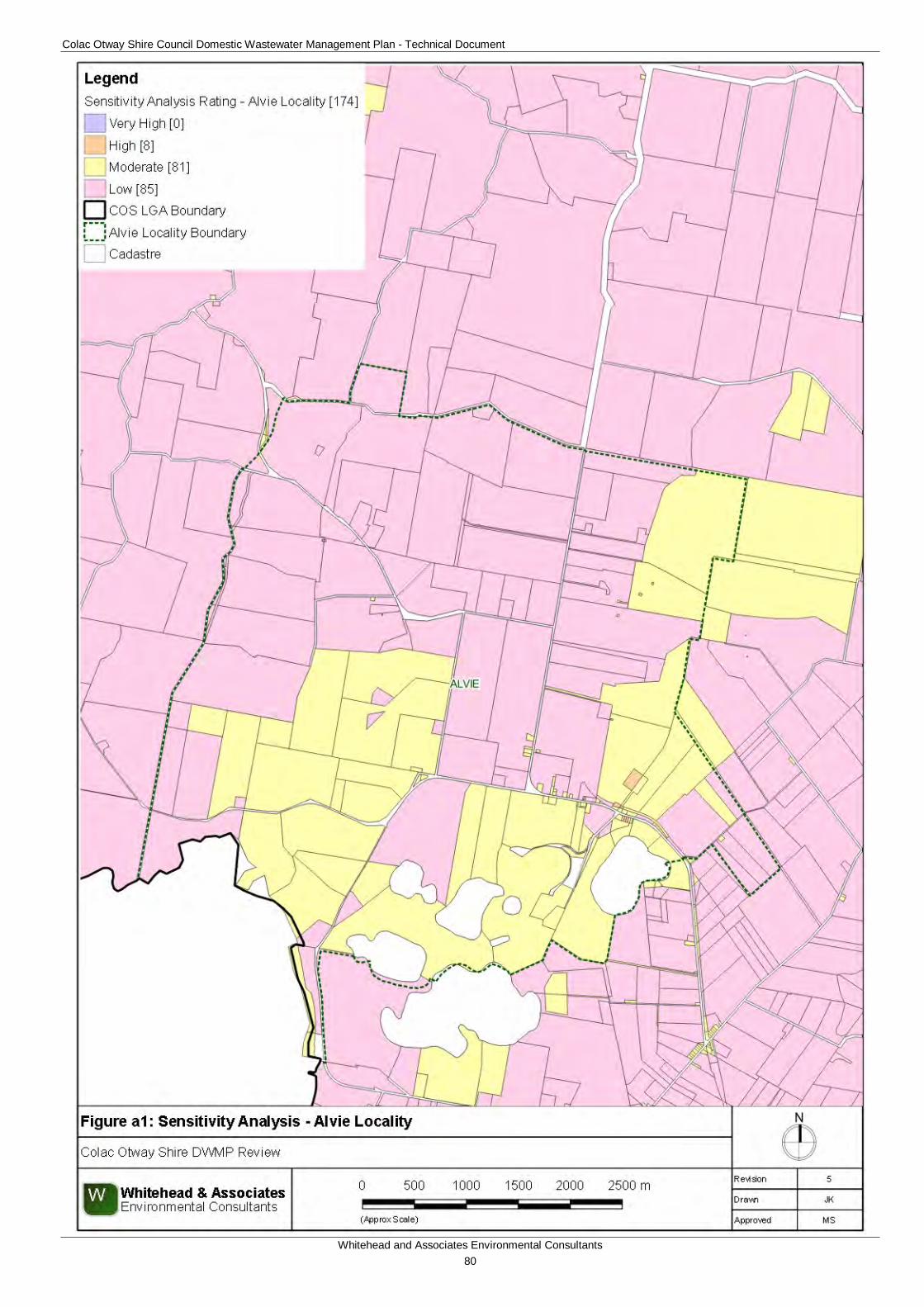
Colac Otway Shire Council Domestic Wastewater Management Plan - Technical Document
Whitehead and Associates Environmental Consultants 80
Colac Otway Shire Council Domestic Wastewater Management Plan - Technical Document
Whitehead and Associates Environmental Consultants 81
Colac Otway Shire Council Domestic Wastewater Management Plan - Technical Document
Whitehead and Associates Environmental Consultants 82
5a. System Selection Due to the dominance of heavy-textured soils in the Alvie area, conventional absorption trenches and beds are not likely to be feasible and are discouraged. Appendix A of the EPA Code of Practice (2013) prohibits LPED systems on Category 5 and 6 soils (medium to heavy clays). The System Sizing Tables (below) indicate which systems are likely to be the most appropriate for the locality.
6a. System Sizing Tables Sizing Tables for each system type were created using conservative monthly water balances, following methods described in the MAV Model LCA, 2014. Monthly 70th percentile rainfall and average evapotranspiration data for Alvie was sourced from SILO (Scientific Information for Land Owners) climate databases, which are managed by the Queensland Government. The SILO databases use accurate meteorological data collected throughout Australia over long time periods.
The Design Loading Rates (DLRs) and Design Irrigation Rates (DIRs) were taken from the EPA Code of Practice. Where the Code of Practice has precluded use of a particular type of system on a certain soil type, it is shown as ‘Not Applicable’ for that soil type in the Sizing Tables. Where the evapotranspiration deficit requires unrealistically large land application areas for a particular system on a certain soil type, it is also shown as ‘Not Applicable’ for that soil type in the Sizing Tables. Detailed, site-specific LCAs and system designs would be required to further investigate the feasibility of systems deemed ‘Not Applicable’ in the sizing tables. Mitigation measures (such as importation of topsoil to appropriate depths in the land application area), may be required to sustainably achieve land application of effluent on constrained properties/parcels.
Sizing Tables for the Alvie locality are provided below.
7a. General Conclusion The properties/parcels within Alvie have been predominantly assigned a Moderate or Low Sensitivity Rating to sustainable DWM. Predominantly, both Standard and Council LCAs will be required, with the use of System Sizing tables deemed appropriate. The constraints within Alvie are quite low in comparison to other localities, with particular attention directed towards ensuring that the quality of the groundwater resources is maintained and the correct decommissioning of groundwater bores occurs where necessary.

Colac Otway Shire Council Domestic Wastewater Management Plan - Technical Document
Whitehead and Associates Environmental Consultants 83
Soil Category Gravels & Sands (1) Sandy Loams (2) Loams (3) Clay Loams (4) Light Clays (5) Medium to Heavy
Clays (6)DIR (mm) 5 5 4 3.5 3 2
Development Type Daily (L/day)5 + bedroom residence 1,080 356 426 530 1,0394 bedroom residence 900 297 355 442 866
1-3 bedroom residence 720 237 284 353 693
Soil Category Gravels & Sands (1) Sandy Loams (2) Loams (3)
Weak Loams & High/Mod Clay Loams (3 & 4)
Weak Clay Loams (4)
Massive Clay Loams (4) Light Clays (5) Medium to Heavy
Clays (6)
DLR (mm)Development Type Daily (L/day)
5 + bedroom residence 1,0804 bedroom residence 900
1-3 bedroom residence 720
Soil Category Gravels & Sands (1) Sandy Loams (2) Loams (3a) Weak/Massive
Loams (3b)High/Mod Clay
Loams (4a)
Weak Clay Loams (4b) & Strong
Light Clays (5a)
Massive Clay Loams (4c) and
Mod & Weak Light Clays (5b, 5c)
Medium to Heavy Clays (6) - Secondary
Effluent Only
DLR (mm) 20* 20* 15 10 12 8 5 5Development Type Daily (L/day)
5 + bedroom residence 1,080 78 123 100 1284 bedroom residence 900 65 102 83 132
1-3 bedroom residence 720 52 82 67 106
Soil Category Gravels & Sands (1) Sandy Loams (2) Loams (3) Clay Loams (4) Light Clays (5) Medium to Heavy
Clays (6)DIR (mm) 4 3.5 3
Development Type Daily (L/day)5 + bedroom residence 1,080 379 460 5844 bedroom residence 900 316 383 487
1-3 bedroom residence 720 253 307 390
Soil Category Gravels & Sands (1)
Sandy Loams (2) Loams (3) &
High/Mod Clay Loams (4a,b)
Weak Clay Loams (4)
Massive Clay Loams (4)
Strong Light Clays (5a)
Moderate Light Clays (5b)
Weak Light Clays (5c)
Medium to Heavy Clays (6)
DLR (mm) 25 30 20 10 12 8 8 5Development Type Daily (L/day)
5 + bedroom residence 1,080 46 38 58 123 100 2814 bedroom residence 900 38 32 48 102 83 234
1-3 bedroom residence 720 31 25 39 82 67 188106
N/A (Alternative Land
Application System Required)
N/A (Alternative Land
Application System Required)
Wick Trenches and Beds - Secondary Treated Effluent Only
† required for zero wet weather storage (m2) not including spacing & setbacks
Note: * irrigation system sizes are based on the assumption that the land application area is less than 10% slope. Reductions in DIR apply for slopes above 10% according to Table M2 of AS1547:2012
Conventional Absorption Trenches and Beds - Primary or Secondary Treated Effluent
Not supported (Alternative Land Application System Required)
128132
Drip and Spray Irrigation Systems* - Secondary Treated Effluent only
Total min. basal or 'wetted' area required for zero wet weather effluent storage (m2) not including spacing and setbacks
Evapotranspiration-Absorption Trenches and Beds - Primary or Secondary Treated Effluent (Category 1 to 5) and Secondary Treated Effluent only (Category 6)
LPED Irrigation Systems - Primary or Secondary Treated Effluent
Total min. irrigation area required for zero wet weather effluent storage (m2) not including spacing and setbacks
5848
268223127
Note: * Gravels, Sands and sandy loams are unsuitable for conventional absorption trenches and beds if there is a high watertable, including seasonal and perched watertables. Value based on average of conservative rate and maximum rate for Category 2b and 3a soils in AS1547:2012
39
Alvie and Beeac
281234188
Total min. basal or 'wetted' area required (m2)†N/A
(Alternative Land Application System
Required)
Total min. basal or 'wetted' area required for zero wet weather effluent storage (m2) not including spacing and setbacks
Colac Otway Shire Council Domestic Wastewater Management Plan - Technical Document
Whitehead and Associates Environmental Consultants 84
B. Barham River Catchment (Apollo Bay) Locality Report 1b. Introduction Barham River (also known informally as ‘Paradise’) is a rural settlement located in the hinterlands of the Apollo Bay locality on the south-eastern coast of COS. On maps, it is officially within the broader Apollo Bay locality, but it is distinguished by low density, unsewered residential properties primarily extending along Barham River Road and other minor roads. Many properties are rural-residential (including hobby farms). The landform consists of dissected low hills and alluvial terraces abutting rivers and streams at the base of the Otway Ranges. The entire Barham River (‘Paradise’) Catchment settlement is located within the Barham River DWSC as indicated by the surface water informative map A1, Appendix A.
The settlement of Apollo Bay is sewered, with approximately 366 and 81 unsewered properties/parcels located within the Apollo Bay locality and Barham River Catchment settlement, respectively. There are 140 DWM system permits that have been inspected by COS to date within the Barham River Catchment settlement/ Apollo Bay locality. The current DWM permits and their associated treatment system and LAA method are summarised as follows:
• 51 AWTS (7 subsurface irrigation, 16 drip irrigation, 8 irrigation, 3 trenches and 17 unknown);
• 2 composting toilets (1 drip irrigation);
• 56 septic tanks (27 trenches and 29 unknown);
• 2 worm farms (2 trenches); and
• 29 unknown (11 trenches, 1 reln drain, 1 subsurface irrigation, and 16 unknown).
2b. Background Documentation Refer to the following documents for additional detail specifically regarding the locality:
• Apollo Bay Structure Plan (April 2007);
• Barham River Confluence Land Management Plan (February 2012);
• COS Planning Scheme; and
• Rural Living Strategy (2011)
3b. Site Assessment Results The following table summarises the results from the representative audits conducted by Consultant staff in September 2014.
Colac Otway Shire Council Domestic Wastewater Management Plan - Technical Document
Whitehead and Associates Environmental Consultants 85
Characteristic Description
Land use The Barham River Catchment settlement comprises a range of land uses, including rural living, small farms, and tourism.
Occupancy rates 2 (as per Apollo Bay Gazetted Locality, ABS Census, 2011).
Typical soils Sandy clays and clay loams over clay or weathered shallow bedrock as determined during field investigations.
AS/NZS 1547:2012 soil categories
4 (Clay Loams), 5 (Light and Sandy Clays) and 6 (Medium to Heavy Clays).
Existing Systems
Separate Blackwater and Greywater
Of the three systems inspected during field investigations, one (33%) was assumed to comprise separate blackwater treatment in a septic tank, with direct greywater diversion within the property/parcel boundary. The septic tank was not accessed, as it could not be found. Time since last pump out was not determined.
It was assumed that septic effluent is discharged to conventional absorption trenches; however, the LAA was not identified.
Combined Blackwater and Greywater
Two systems (67%) inspected have a combined wastewater treatment system, or were assumed to have based on layout of pipework and age of dwelling. The time since last pump-out was generally unknown (partly due to owner not being home to ascertain).
Septic effluent discharged to one or more conventional absorption trenches (or was assumed to if trenches could not be identified). The trench dimensions were generally unclear, and it is likely that they were undersized for the number of bedrooms. The majority of trenches or/and available LAAs were located on land of less than 8% slope and appeared to be parallel with contours.
4b. Summary of Constraints to DWM Characteristic Description
Climate Zone Zone 3.
Surface waterways & catchments
Approximately half of the broader Apollo Bay locality is within a DWSC. The entirety of the Barham River (‘Paradise’) Catchment settlement is located in the Barham River DWSC, which is the drinking water supply for connected properties in Apollo Bay. Barham River (east and west branches) is the major watercourse and has tributaries throughout the catchment.
Barham River confluences with the Southern Ocean between the
Colac Otway Shire Council Domestic Wastewater Management Plan - Technical Document
Whitehead and Associates Environmental Consultants 86
Characteristic Description
settlements of Marengo and Apollo Bay.
Groundwater Proximity to groundwater bores: primarily around semi-rural properties/parcels on the outskirts (west and northwest) of Apollo Bay settlement.
No depth to groundwater data.
Land subject to inundation
Along the lower coastal creek reaches, particularly at the Barham River confluence with the Southern Ocean.
Useable lot area
Settlement (Locality)
High: 16 (76)
Moderate: 8 (24)
Low: 56 (260)
Compliant: 1 (6)
Minimum lot size compliance with Planning Scheme Zoning
The Barham River (‘Paradise’) Catchment settlement is primarily zoned Rural Conservation Zone and is located to the west and northwest of the Apollo Bay town, in the foot slopes of the Otway Ranges.
Compliancy is variable throughout the broader Apollo Bay locality, with a greater density of non-compliant properties/parcels located to the south, west and north of the Apollo Bay settlement.
Compliant: 22 (98)
Non-compliant: 59 (268)
Slope
Settlement (Locality)
High: 76 (285) (particularly around the Otway Ranges foot slopes)
Moderate: 3 (41)
Low: 2 (40)
Geology Sedimentary Eumeralla Formation (early Cretaceous), fluvial braided stream deposits, unnamed Quaternary sedimentary (non-marine) colluvium and gully alluvium, and alluvial floodplain deposits. It differs along the coastline near the town of Apollo Bay.
Soil suitability
Settlement (Locality)
High: 2 (113)
Moderate: 79 (253)
Low: 0 (0)
Northern region/hinterland region consists of soil landscape unit ‘61’ (moderate rating) which forms in the deeply dissected hills of the Otway Ranges and consists of brown gradational soils to 1.2m depth. The soils consist of moderately structured silty loam over clay loam. Limitations include restricted drainage and very acidic soil.
Colac Otway Shire Council Domestic Wastewater Management Plan - Technical Document
Whitehead and Associates Environmental Consultants 87
Characteristic Description
The western region of the Apollo Bay locality and extending northeast along the coastline towards Skenes Creek consists of soil landscape unit ’64’ (moderate rating) which forms in the similar landscape as detailed in ‘61’. It consists of brown texture contrast soils to 0.9m depth. The soils consist of weakly structured clay sand over strongly structured clay loam.
The northern half of the Apollo Bay locality consists of soil landscape unit ‘62’ (high rating) which forms in the alluvium, alluvial terraces, floodplains and coastal plains of the Sedimentary Western Plains and elevated longitudinal coastal dunes at Cape Otway and consists of red-yellow calcareous sand soils to 1.9m depth. The soils consist of apedal loamy sand over weakly structured sandy clay. Limitations include low fertility and coarse fragments.
The southern half of the Apollo Bay locality consists of soil landscape unit ‘91’ (high rating) which forms in the deeply dissected and uplifted plains with coastal cliffs and consists of grey sand soils with hardpans to more than 2m depth. The soils consist of weakly structured loamy sand over apedal sand. Limitations include low fertility and coarse fragments.
There is a small region in the southwest of the locality that consists of medium clay deep grey gradational soils.
Sensitivity Overlay
No depth to groundwater data
Landslip: extensive within the eastern (coastal) section of locality, significant in the foot slopes of the Otway Ranges.
Vegetation: Great Otway National Park in the northwest.
Sensitivity Analysis Rating
Settlement (Locality)
Very High: 0 (8)
High: 22 (122)
Moderate: 59 (236)
Low: 0 (0)
5b. Sensitivity Analysis (Maps)
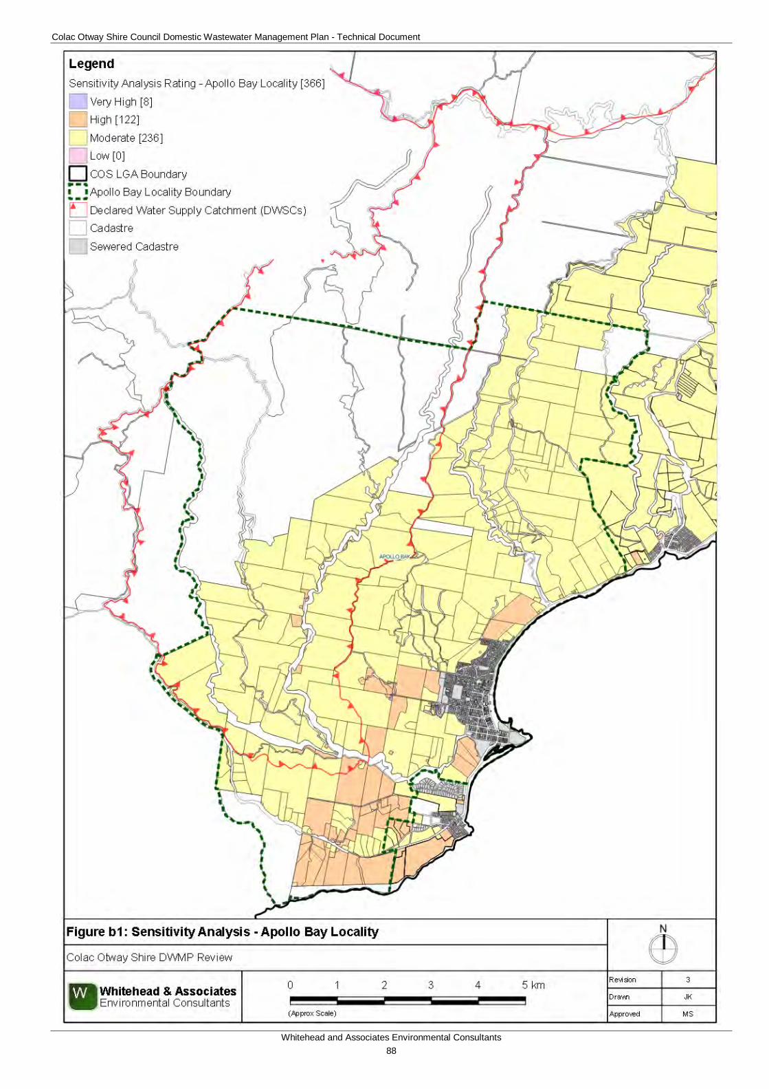
Colac Otway Shire Council Domestic Wastewater Management Plan - Technical Document
Whitehead and Associates Environmental Consultants 88
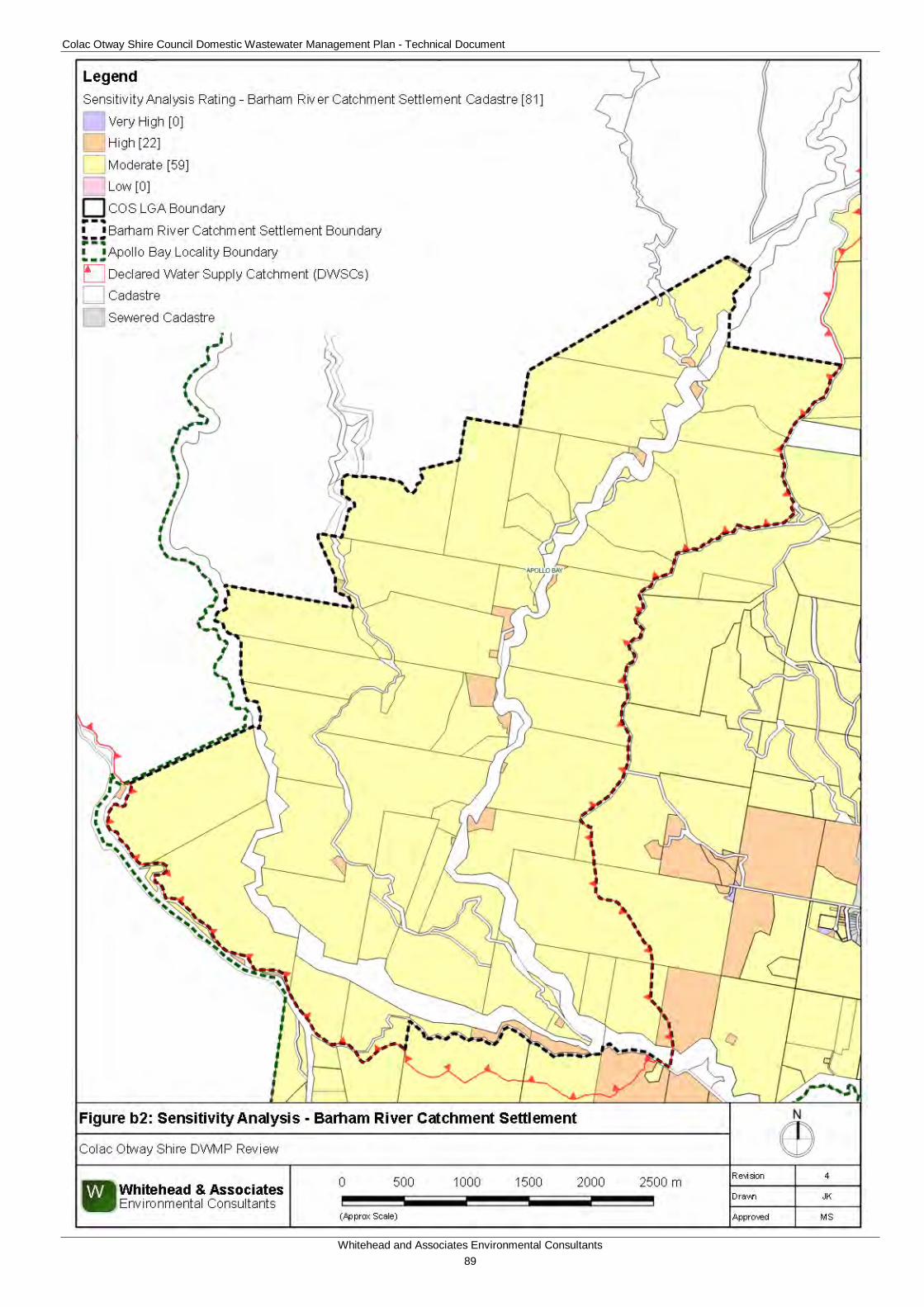
Colac Otway Shire Council Domestic Wastewater Management Plan - Technical Document
Whitehead and Associates Environmental Consultants 89
Colac Otway Shire Council Domestic Wastewater Management Plan - Technical Document
Whitehead and Associates Environmental Consultants 90
6b. System Selection Due to the dominance of heavy-textured soils in the Barham River Catchment settlement, conventional absorption trenches and beds are not likely to be feasible and are discouraged. Appendix A of the EPA Code of Practice (2013) prohibits LPED systems on Category 5 and 6 soils (medium to heavy clays).
The wet climate of the Barham River Catchment settlement makes it a higher risk for DWM and site-specific, detailed design will be required for unsewered properties/parcels in this area. Mitigation measures (such as importation of topsoil to appropriate depths in the land application area), may be required to sustainably achieve land application of effluent on constrained properties/parcels.
EPA Code of Practice (2013) (Section 2.2.2) identifies secondary treatment standard (or better) followed by subsurface pressure-compensating irrigation as current best-practice in Victoria for substantially reducing the risk associated with unsewered development. Further, the Code describes a “Wick trench/bed” land application option that may be incorporated with secondary treatment for consideration on sites constrained by climate or lot ‘useable area’, particularly within the DWSCs. Any variation from this best-practice approach must be provided with detailed supporting information to demonstrate suitability.
The Sizing Tables (discussed below) are not applicable for the Barham River Catchment settlement.
7b. System Sizing Tables Sizing Tables for each system type were created using conservative monthly water balances, following methods described in the MAV Model LCA (2014). 70th percentile monthly rainfall exceeds average monthly evapotranspiration in eight months of the year in the Barham River area. As a result, there is a month-to-month surplus of hydraulic inputs and subsequently the monthly water balance does not resolve itself and cannot produce meaningful results for land application area sizing.
Site-specific detailed design is required for the Barham River Catchment settlement.
8b. General Conclusion The majority of the properties/parcels within the locality have been assigned a Moderate or High Sensitivity Rating to sustainable DWM. Predominantly, both Standard and Detailed LCAs will be required, with site-specific design a necessity due to the higher rainfall associated with this region. System Sizing Tables were not generated and a monthly water balance will need to be generated for system sizing for the Standard LCA. Particular attention needs to be directed towards ensuring that setbacks from surface waterways are maintained and that the systems selected are appropriate for steeper slopes with correct construction.
Colac Otway Shire Council Domestic Wastewater Management Plan - Technical Document
Whitehead and Associates Environmental Consultants 91
C. Barongarook Locality Report 1c. Introduction Barongarook is located in the centre of COS approximately 9km south of Colac. The landform consists of dissected low hills and alluvial terraces abutting a stream on the northern foothills of the Otway Ranges. Notably, the entire settlement and surrounding locality is located within a DWSC, predominantly Barwon Downs Wellfield Intake DWSC and Gellibrand River DWSC in the southwest, as indicated by the surface water informative map, Appendix A.
There are approximately 265 and 101 unsewered properties/parcels located within the Barongarook locality and settlements, respectively, with 121 DWM system permits that have been inspected to date by COS. The current DWM permits and their associated treatment system and LAA method within the Barongarook locality are summarised as follows:
• 15 AWTS (5 subsurface irrigation,, 4 drip irrigation, 1 irrigation and 4 unknown);
• 2 sand filters (1 subsurface irrigation and 1 drip irrigation);
• 64 septic tanks (11 trenches, 1 subsurface irrigation and 52 unknown); and
• 40 unknown (12 trenches, 3 subsurface irrigation, 3 irrigation, and 22 unknown).
No field investigations were conducted in the Barongarook locality as part of the 2014 field assessments; however, soil investigations were conducted to confirm the soil type.
2c. Background Documentation Refer to the following documents for additional detail regarding the locality:
• Barongarook Covenant Reserve Land Management Plan (February, 2012);
• COS Planning Scheme; and
• Rural Living Strategy (2011).
3c. Summary of Constraints to DWM Characteristic Description
Climate Zone Zone 3.
Surface waterways & catchments
The locality is located entirely within the Barwon Downs Wellfield Intake (Geelong) DWSC and Gellibrand River DWSC in the south. Boundary Creek is located to the south of the settlement, traversing southwest-northeast. Ten Mile Creek and Dividing Creek are also located to the south of the settlement. Tributaries of the Barongarook Creek West Branch flow into the surrounding region from the north into the settlement.
Groundwater Proximity to groundwater bores: distributed throughout.
Land subject to inundation
Nil
Colac Otway Shire Council Domestic Wastewater Management Plan - Technical Document
Whitehead and Associates Environmental Consultants 92
Characteristic Description
Useable lot area
Settlement (Locality)
High: 18 (26)
Moderate: 6 (16)
Low: 77 (216)
Compliant: 0 (7)
Minimum lot size compliance with Planning Scheme Zoning
The locality is predominately in the Farming Zone with some Public Conservation and Resource Zone to the southeast. The settlements (one in the south and the other in the north) are zoned Rural Living.
Properties/parcels are predominantly non-compliant, including both settlement areas.
Compliant: 0 (15)
Non-compliant: 101 (250)
Slope
Settlement (Locality)
High: 1 (16)
Moderate: 16 (48)
Low: 84 (37)
Geology Dilwyn Formation of the Wangeripp Group (Eocene age) which consists of shallow marine, coastal barrier and back beach lagoonal deposits. Intertwined with Demons Bluff formation of the Niranda Group which consists of shallow marine and minor lagoonal deposits, with some alluvial and fluvial deposits associated with the Eumeralla Formation.
Soil suitability
Settlement (Locality)
High: 0 (0)
Moderate: 101 (265)
Low: 0 (0)
Variable soil landscapes (four).
The majority of the locality and southern region of the northern settlement area consists of soil landscape unit ‘88’ which forms along the rolling plains in the western part of the Barwon catchment and northern parts of the Gellibrand catchment and consists of grey sand soils to more than 2m depth. The soils consist of apedal sandy loam to sand over weakly structured sandy clay. Limitations include low fertility and coarse fragments.
The northwest region of the locality consists of soil landscape unit ‘92’ (moderate rating) which forms in the undulating plain in the north part of the Gellibrand River Catchment and consist of mottled yellow and red gradational soil to more than 2m depth. The soils consist of moderately structured sandy loam over light clay. Limitations include low fertility and low p-sorb.
Colac Otway Shire Council Domestic Wastewater Management Plan - Technical Document
Whitehead and Associates Environmental Consultants 93
Characteristic Description
Around Bushbys Road in the northwest consists of soil landscape unit ‘93’ (moderate rating) which forms in the gently undulating plain in the western parts of Barwon Catchment and consist of mottled gradational soil to more than 2m depth. The soils consist of weakly structured loam over moderately structured medium clay. Limitations include low fertility, p-sorb and coarse fragments.
The southwest region of the locality consists of soil landscape unit ‘90’ which forms on the rolling hills in the northern upper reaches of the Gellibrand catchment and consists of mottled gradational soil to more than 2m depth. The soil consists of apedal fine sandy loam over weakly structured silty clay loam. Limitations include low p-sorb, low fertility and restricted drainage.
Sensitivity Overlay
Depth to Groundwater Compliance: variable compliancy; predominantly compliant, except for the middle of the locality and a few properties/parcels in the northern settlement.
Landslip: minimal.
Vegetation: Otway Forest Park and Great Otway National Park to the south to southeast.
Sensitivity Analysis Rating
Settlement (Locality)
Very High: 0 (0)
High: 2 (7)
Moderate: 99 (258)
Low: 0 (0)
4c. Sensitivity Analysis (Maps)
Colac Otway Shire Council Domestic Wastewater Management Plan - Technical Document
Whitehead and Associates Environmental Consultants 94
Colac Otway Shire Council Domestic Wastewater Management Plan - Technical Document
Whitehead and Associates Environmental Consultants 95
Colac Otway Shire Council Domestic Wastewater Management Plan - Technical Document
Whitehead and Associates Environmental Consultants 96
5c. System Selection Due to the dominance of heavy-textured soils in the Barongarook locality, conventional absorption trenches and beds are not likely to be feasible and are discouraged. Appendix A of the EPA Code of Practice (2013) prohibits LPED systems on Category 5 and 6 soils (medium to heavy clays).
EPA Code of Practice (2013) (Section 2.2.2) identifies secondary treatment standard (or better) followed by subsurface pressure-compensating irrigation as current best-practice in Victoria for substantially reducing the risk associated with unsewered development. Further, the Code describes a “Wick trench/bed” land application option that may be incorporated with secondary treatment for consideration on sites constrained by climate or lot ‘useable area’, particularly within the DWSCs. Any variation from this best-practice approach must be provided with detailed supporting information to demonstrate suitability.
The System Sizing Tables (below) indicate which systems are likely to be the most appropriate for the locality.
6c. System Sizing Tables Sizing Tables for each system type were created using conservative monthly water balances, following methods described in the MAV Model LCA, 2014. Monthly 70th percentile rainfall and average evapotranspiration data for Barongarook was sourced from SILO (Scientific Information for Land Owners) climate databases, which are managed by the Queensland Government. The SILO databases use accurate meteorological data collected throughout Australia over long time periods.
The Design Loading Rates (DLRs) and Design Irrigation Rates (DIRs) were taken from the current EPA Code of Practice. Where the Code of Practice has precluded use of a particular type of system on a certain soil type, it is shown as ‘Not Applicable’ for that soil type in the Sizing Tables. Where the evapotranspiration deficit requires unrealistically large land application areas for a particular system on a certain soil type, it is also shown as ‘Not Applicable’ for that soil type in the Sizing Tables. Detailed, site-specific LCAs and system designs would be required to further investigate the feasibility of systems deemed ‘Not Applicable’ in the sizing tables. Mitigation measures (such as importation of topsoil to appropriate depths in the land application area), may be required to sustainably achieve land application of effluent on constrained properties/parcels.
Sizing Tables for Barongarook are provided below.
7c. General Conclusion The properties/parcels within the locality have predominantly been assigned a Moderate Sensitivity to sustainable DWM, with some properties/parcels assigned a Low or High Sensitivity Rating. Predominantly, the Standard LCA will be required, with use of the System Sizing tables deemed appropriate. The Low Sensitivity Rating properties/parcels within a DWSC are required to complete a Standard LCA as per the current EPA Code of Practice’s requirements. Particular attention needs to be directed towards assessing cumulative impact of DWM systems on the environment to ensure that the DWSCs are protected and that groundwater resources are preserved.
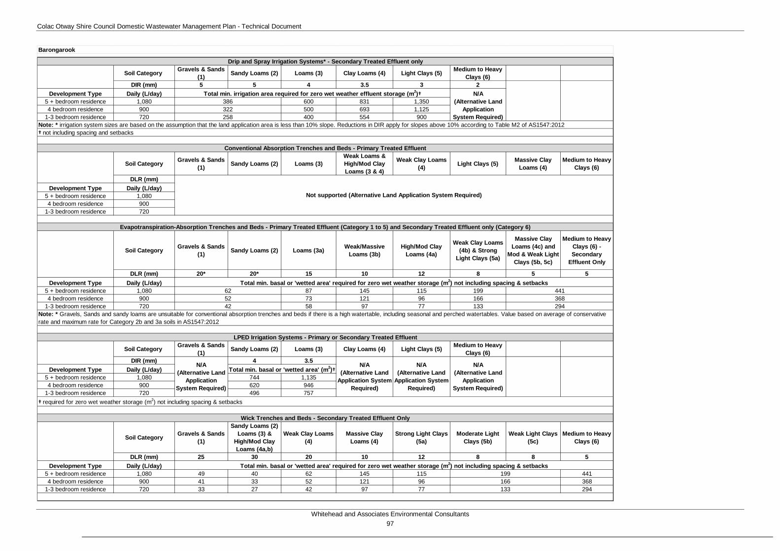
Colac Otway Shire Council Domestic Wastewater Management Plan - Technical Document
Whitehead and Associates Environmental Consultants 97
Soil Category Gravels & Sands (1) Sandy Loams (2) Loams (3) Clay Loams (4) Light Clays (5) Medium to Heavy
Clays (6)DIR (mm) 5 5 4 3.5 3 2
Development Type Daily (L/day)5 + bedroom residence 1,080 600 831 1,3504 bedroom residence 900 500 693 1,125
1-3 bedroom residence 720 400 554 900
Soil Category Gravels & Sands (1) Sandy Loams (2) Loams (3)
Weak Loams & High/Mod Clay Loams (3 & 4)
Weak Clay Loams (4) Light Clays (5) Massive Clay
Loams (4)Medium to Heavy
Clays (6)
DLR (mm)Development Type Daily (L/day)
5 + bedroom residence 1,0804 bedroom residence 900
1-3 bedroom residence 720
Soil Category Gravels & Sands (1) Sandy Loams (2) Loams (3a) Weak/Massive
Loams (3b)High/Mod Clay
Loams (4a)
Weak Clay Loams (4b) & Strong
Light Clays (5a)
Massive Clay Loams (4c) and
Mod & Weak Light Clays (5b, 5c)
Medium to Heavy Clays (6) - Secondary
Effluent Only
DLR (mm) 20* 20* 15 10 12 8 5 5Development Type Daily (L/day)
5 + bedroom residence 1,080 87 145 115 1994 bedroom residence 900 73 121 96 166
1-3 bedroom residence 720 58 97 77 133
Soil Category Gravels & Sands (1) Sandy Loams (2) Loams (3) Clay Loams (4) Light Clays (5) Medium to Heavy
Clays (6)DIR (mm) 4 3.5
Development Type Daily (L/day)5 + bedroom residence 1,080 744 1,1354 bedroom residence 900 620 946
1-3 bedroom residence 720 496 757
Soil Category Gravels & Sands (1)
Sandy Loams (2) Loams (3) &
High/Mod Clay Loams (4a,b)
Weak Clay Loams (4)
Massive Clay Loams (4)
Strong Light Clays (5a)
Moderate Light Clays (5b)
Weak Light Clays (5c)
Medium to Heavy Clays (6)
DLR (mm) 25 30 20 10 12 8 8 5Development Type Daily (L/day)
5 + bedroom residence 1,080 49 40 62 145 115 4414 bedroom residence 900 41 33 52 121 96 368
1-3 bedroom residence 720 33 27 42 97 77 294
Barongarook
294
Total min. basal or 'wetted area' required for zero wet weather storage (m2) not including spacing & setbacks
199166
N/A (Alternative Land
Application System Required)
N/A (Alternative Land
Application System Required)
N/A (Alternative Land
Application System Required)
Total min. irrigation area required for zero wet weather effluent storage (m2)†
N/A (Alternative Land
Application System Required)
N/A (Alternative Land
Application System Required)
Wick Trenches and Beds - Secondary Treated Effluent Only
133
Note: * irrigation system sizes are based on the assumption that the land application area is less than 10% slope. Reductions in DIR apply for slopes above 10% according to Table M2 of AS1547:2012
52
† required for zero wet weather storage (m2) not including spacing & setbacks
Evapotranspiration-Absorption Trenches and Beds - Primary Treated Effluent (Category 1 to 5) and Secondary Treated Effluent only (Category 6)
441368
Total min. basal or 'wetted area' (m2)†
62
Total min. basal or 'wetted area' required for zero wet weather storage (m2) not including spacing & setbacks
† not including spacing and setbacks
Drip and Spray Irrigation Systems* - Secondary Treated Effluent only
LPED Irrigation Systems - Primary or Secondary Treated Effluent
386322
Conventional Absorption Trenches and Beds - Primary Treated Effluent
Note: * Gravels, Sands and sandy loams are unsuitable for conventional absorption trenches and beds if there is a high watertable, including seasonal and perched watertables. Value based on average of conservative rate and maximum rate for Category 2b and 3a soils in AS1547:2012
258
42
Not supported (Alternative Land Application System Required)
Colac Otway Shire Council Domestic Wastewater Management Plan - Technical Document
Whitehead and Associates Environmental Consultants 98
D. Barwon Downs Locality Report 1d. Introduction The Barwon Downs locality is located on the northern slopes of the Otway Ranges, with the town located on the northern foothills. The landform consists of dissected hills abutting rivers and streams, and alluvial terraces with relatively flat topography. The majority (approximately 80%) of the region is located within a DWSC, with the town located within the Upper Barwon DWSC. The region to the northeast of the town also falls within the Gosling Creek DWSC.
There are approximately 267 and 89 unsewered properties/parcels located within the Barwon Downs locality and town, respectively, with 62 DWM system permits that have been inspected to date by COS. The current DWM permits and their associated treatment system and LAA method within the Barwon Downs region are summarised as follows:
• 8 AWTS (4 subsurface irrigation, 1 trench and 3 unknown);
• 1 composting toilet (1 unknown);
• 10 sand filters (10 subsurface irrigation);
• 30 septic tank (6 trenches and 24 unknown);
• 4 worm farms (3 trenches and 1 unknown); and
• 9 unknown (3 trenches and 6 unknown).
2d. Background Documentation Refer to the following documents for additional detail regarding the locality:
• Barwon Downs Township Master Plan Report (June, 2006);
• COS Planning Scheme; and
• Rural Living Strategy (2011).
3d. Site Assessment Results The following table summarises the results from the representative audits conducted by Consultant staff in September 2014.
Characteristic Description
Land use Barwon Downs comprises a range of land uses, including dairy, forestry, rural living and tourism.
Occupancy rates 2.3 (Barwon Downs State Suburb, ABS Census, 2011).
Typical soils
Yellow mottled duplex soil with very deep (60 cm) silt loam grading to silty clay loam surface and subsurface over strongly mottled clay subsoil; between 25-60 cm the subsurface was saturated (25 July 2014). Drainage is generally poor and permeability is generally low.
AS/NZS 1547:2012 soil categories 5 (Light Clays) and 6 (Medium to Heavy Clays)
Colac Otway Shire Council Domestic Wastewater Management Plan - Technical Document
Whitehead and Associates Environmental Consultants 99
Characteristic Description
Existing Systems
Separate Blackwater and Greywater
Of the eight systems inspected during field investigations, seven systems (88%) comprised separate blackwater treatment in a septic tank or composting toilet, with direct greywater diversion to an adjacent paddock, street drain, trench or AWTS. Where discharged to paddocks or neighbouring vacant properties/parcels, greywater was typically ponded near the diversion outlet pipe, and often in areas trampled by livestock (cattle and sheep).
The blackwater septic tanks were typically 40+ years old and the time since last pump-out was unknown for the majority (due to owners not being home to ascertain). Septic effluent discharged to one or more conventional absorption trenches (or was assumed to if trenches could not be identified). The trench dimensions were generally unclear, and it is likely that most trenches were undersized for the number of bedrooms. The majority of trenches or/and available LAAs were located on land of less than 4% slope and appeared to be parallel with contours.
One greywater diversion system was pumped with a home-made pump-well, with moveable sprinklers around fruit trees. The AWTS had not been serviced since installation approximately 4 years ago and the sprinkler heads periodically become blocked. Setback distances from boundaries were inadequate for this system.
Combined Blackwater and Greywater
One of the eight systems (13%) inspected was assumed to have a combined wastewater treatment system, based on layout of pipework and age of dwelling. Septic effluent discharged to a series of conventional absorption trenches which appeared to be working well and were adequately sized.
4d. Summary of Constraints to DWM Characteristic Description
Climate Zone Majority within Zone 3.
Surface waterways & catchments
The locality consists of an extensive drainage network. It is located within the DWSCs of Upper Barwon, Gosling Creek and a small part of Matthew Creek in the northeast. The locality is predominantly located within a DWSC, except for approximately 1km north of the most northern extent of the town. The major waterways include: Denn Creek to the east of the town, Callahan Creek North and South Branches and Barwon River East Branch to the west and south of the town, Dewing Creek, Seymour Creek, Kind Creek, and Mackie Creek.
Colac Otway Shire Council Domestic Wastewater Management Plan - Technical Document
Whitehead and Associates Environmental Consultants 100
Characteristic Description
Groundwater Proximity to groundwater bores: primarily located around the town and north-western region of the locality.
Land subject to inundation Along Barwon River East Branch and Callahan Creek.
Useable lot area
Town (Locality)
High: 43 (77)
Moderate: 23 (29)
Low: 23 (154)
Compliant: 0 (7)
Minimum lot size compliance with Planning Scheme Zoning
The locality is predominantly zoned Farming Zone to the north and Public Conservation and Resource Zone to the south. The town is zoned as Township Zone.
Compliancy is variable throughout the locality, with the town predominantly compliant.
Compliant: 84 (123)
Non-compliant: 5 (144)
Slope
Town (Locality)
High: 0 (50) (in southern region)
Moderate: 1 (22)
Low: 88 (195)
Geology Eumeralla Formation of the Otway Group is predominant in the east, intertwined with the Dilwyn Formation of the Wangeripp Group (Eocene age) which consists of shallow marine, coastal barrier and back beach lagoonal deposits. Intertwined with Demons Bluff formation of the Niranda Group which consists of shallow marine and minor lagoonal deposits, with some unnamed alluvium flood plain deposits along waterways. The northwest corner is underlain by Gellibrand Marl from the Heytesbury Group continental shelf deposit.
Soil suitability High: 0 (20)
Moderate: 89 (247)
Low: 0 (0)
Variable soil throughout the locality (7 different units); however, it is noted that the locality is spatially expansive.
The town consists of soil landscape units ‘78’ and ‘73’ which form on the undulating plain inland of Otway Range and steep rolling hills on the northern periphery of the Otway Range and consists of texture contrast soils with ironstone to 2m depth. The soils consist of weakly structured sandy loam over strongly structured medium to heavy clay.
Colac Otway Shire Council Domestic Wastewater Management Plan - Technical Document
Whitehead and Associates Environmental Consultants 101
Characteristic Description
Limitations include low fertility, low p-sorb, sodic, dispersive, restricted drainage and coarse fragments.
The central west region consists of soil landscape unit ‘76’ which form on the undulating plains and consist of grey sand soils to more than 2m depth. The soils consist of weakly structured loamy sand over apedal sand. Limitations include low fertility.
The northeast to southwest transversing region consists of soil landscape unit ‘63’ which forms on deeply dissected hills of the Otway Ranges and consists of brown texture contrast soils to 0.9m depth. The soils consist of weakly structured loam over strongly structured heavy clay. Limitations include sodicity and very acidic.
The southern region consists of soil landscape unit ‘61’ which also form on the deeply dissected hills of the Otway Ranges and consist of brown gradational soils to 1.2m depth. The soils consist of moderately structured silty loam over clay loam. Limitations include acidity and restricted drainage.
The regions adjacent to the river consist of soil landscape unit ‘95’ which forms on the alluvial floodplain of the Barwon River and its tributaries with numerous cut-off meanders. The soil consists of a moderately structured fine sandy clay loam over medium clay to more than 2m depth. Limitations include restricted drainage and dispersive.
Sensitivity Overlay
Depth to Groundwater Compliance: predominantly compliant, except to the north and west of the town along Barwon River East Branch.
Landslip: some to the south
Vegetation: Great Otway National, Otway Forest Park, and Barwon Downs bushland reserve.
Sensitivity Analysis Rating
Town (Locality)
Very High: 0 (1)
High: 0 (27)
Moderate: 89 (232)
Low: 0 (7)
5d. Sensitivity Analysis (Maps)
Colac Otway Shire Council Domestic Wastewater Management Plan - Technical Document
Whitehead and Associates Environmental Consultants 102
Colac Otway Shire Council Domestic Wastewater Management Plan - Technical Document
Whitehead and Associates Environmental Consultants 103
Colac Otway Shire Council Domestic Wastewater Management Plan - Technical Document
Whitehead and Associates Environmental Consultants 104
6d. System Selection Due to the dominance of heavy-textured soils in the Barwon Downs locality, conventional absorption trenches and beds are not likely to be feasible and are discouraged. Appendix A of the EPA Code of Practice (2013) prohibits LPED systems on Category 5 and 6 soils (medium to heavy clays). Current best-practice is for effluent to be treated to a secondary standard or better, particularly within the DWSCs. Any variations to this must be provided with detailed evidence and explanations to demonstrate its suitability.
The System Sizing Tables (below) indicate which systems are likely to be the most appropriate for the locality.
7d. System Sizing Tables Sizing Tables for each system type were created using conservative monthly water balances, following methods described in the MAV Model LCA, 2014. Monthly 70th percentile rainfall and average evapotranspiration data for Barwon Downs was sourced from SILO (Scientific Information for Land Owners) climate databases, which are managed by the Queensland Government. The SILO databases use accurate meteorological data collected throughout Australia over long time periods.
The Design Loading Rates (DLRs) and Design Irrigation Rates (DIRs) were taken from the current EPA Code of Practice. Where the Code of Practice has precluded use of a particular type of system on a certain soil type, it is shown as ‘Not Applicable’ for that soil type in the Sizing Tables. Where the evapotranspiration deficit requires unrealistically large land application areas for a particular system on a certain soil type, it is also shown as ‘Not Applicable’ for that soil type in the Sizing Tables. Detailed, site-specific LCAs and system designs would be required to further investigate the feasibility of systems deemed ‘Not Applicable’ in the sizing tables. Mitigation measures (such as importation of topsoil to appropriate depths in the land application area), may be required to sustainably achieve land application of effluent on constrained properties/parcels.
Sizing Tables for the Barwon Downs locality are provided below.
8d. General Conclusion The properties/parcels within Barwon Downs, including the entire town, have predominantly been assigned a Moderate Sensitivity Rating to sustainable DWM. Predominantly, Standard LCAs will be required, with the use of System Sizing Tables deemed appropriate. The Low Sensitivity Rating properties/parcels within a DWSC are required to complete a Standard LCA as per the current EPA Code of Practice’s requirements. Particular attention needs to be directed towards ensuring that the soil stability and appropriate setbacks to surface waterways and groundwater bores are maintained.
Colac Otway Shire Council Domestic Wastewater Management Plan - Technical Document
Whitehead and Associates Environmental Consultants 105
Soil Category Gravels & Sands (1) Sandy Loams (2) Loams (3) Clay Loams (4) Light Clays (5) Medium to Heavy
Clays (6)DIR (mm) 5 5 4 3.5 3 2
Development Type Daily (L/day)5 + bedroom residence 1,080 684 1,000 1,863 2,5564 bedroom residence 900 570 834 1,552 2,130
1-3 bedroom residence 720 456 667 1,242 1,704
Soil Category Gravels & Sands (1) Sandy Loams (2) Loams (3)
Weak Loams & High/Mod Clay Loams (3 & 4)
Weak Clay Loams (4) Light Clays (5) Massive Clay
Loams (4)Medium to Heavy
Clays (6)
DLR (mm)Development Type Daily (L/day)
5 + bedroom residence 1,0804 bedroom residence 900
1-3 bedroom residence 720
Soil Category Gravels & Sands (1) Sandy Loams (2) Loams (3a) Weak/Massive
Loams (3b)High/Mod Clay
Loams (4a)
Weak Clay Loams (4b) & Strong
Light Clays (5a)
Massive Clay Loams (4c) and
Mod & Weak Light Clays (5b, 5c)
Medium to Heavy Clays (6) - Secondary
Effluent Only
DLR (mm) 20* 20* 15 10 12 8 5 5Development Type Daily (L/day)
5 + bedroom residence 1,080 89 150 118 2084 bedroom residence 900 74 125 98 173
1-3 bedroom residence 720 59 100 79 139
Soil Category Gravels & Sands (1) Sandy Loams (2) Loams (3) Clay Loams (4) Light Clays (5) Medium to Heavy
Clays (6)DIR (mm)
Development Type Daily (L/day)5 + bedroom residence 1,0804 bedroom residence 900
1-3 bedroom residence 720
Soil Category Gravels & Sands (1)
Sandy Loams (2) Loams (3) &
High/Mod Clay Loams (4a,b)
Weak Clay Loams (4)
Massive Clay Loams (4)
Strong Light Clays (5a)
Moderate Light Clays (5b)
Weak Light Clays (5c)
Medium to Heavy Clays (6)
DLR (mm) 25 30 20 10 12 8 8Development Type Daily (L/day)
5 + bedroom residence 1,080 49 40 63 150 1184 bedroom residence 900 41 34 53 125 98
1-3 bedroom residence 720 33 27 42 100 79
Barwon Downs
Total min. irrigation area required for zero wet weather effluent storage (m2) not including spacing or setbacks
Evapotranspiration-Absorption Trenches and Beds - Primary Treated Effluent (Category 1 to 5) and Secondary Treated Effluent only (Category 6)
Wick Trenches and Beds - Secondary Treated Effluent Only
† required for zero wet weather storage (m2) not including spacing or setbacks
139
208173
Total min. basal or 'wetted area' required for zero wet weather storage (m2) not including spacing or setbacksN/A
(Alternative Land Application
System Required)
N/A (Alternative Land
Application System Required)
Total min. basal or 'wetted area' required for zero wet weather storage (m2) not including spacing or setbacks
326
63
N/A (Alternative Land
Application System Required)
N/A (Alternative Land
Application System Required)
Drip and Spray Irrigation Systems* - Secondary Treated Effluent only
Note: * irrigation system sizes are based on the assumption that the land application area is less than 10% slope. Reductions in DIR apply for slopes above 10% according to Table M2 of AS1547:2012
Conventional Absorption Trenches and Beds - Primary Treated Effluent
280
N/A (Alternative Land
Application System Required)
N/A (Alternative Land
Application System Required)
LPED Irrigation Systems - Primary or Secondary Treated Effluent
419349
Note: * Gravels, Sands and sandy loams are unsuitable for conventional absorption trenches and beds if there is a high watertable, including seasonal and perched watertables. Value based on average of conservative rate and maximum rate for Category 2b and 3a soils in AS1547:2012
53
N/A (Alternative Land
Application System Required)
42
488407
Not supported (Alternative Land Application System Required)
Colac Otway Shire Council Domestic Wastewater Management Plan - Technical Document
Whitehead and Associates Environmental Consultants 106
E. Beeac Locality Report 1e. Introduction Beeac is a rural town located on the northern side of Lake Beeac, approximately 19km north of Colac. The landform features undulating agricultural land on the Western Volcanic Plains.
There are approximately 603 and 269 unsewered properties/parcels located within the Beeac locality and town, respectively, with 80 DWM system permits that have been inspected to date by COS. The current DWM permits and their associated treatment system and LAA method within the Beeac locality are summarised as follows:
• 11 AWTS (3 subsurface, 1 trench, 5 drip irrigation, 2 unknown);
• 2 sand filters (1 subsurface irrigation and 1 unknown);
• 43 septic tanks (11 trenches, 1 irrigation and 31 unknown); and
• 24 unknown (6 trenches, 1 subsurface irrigation, and 17 unknown).
No field investigations were conducted within Beeac locality as part of the 2014 field assessments; however, soil investigations were conducted to confirm the soil type. There have been noted issues with the earthen stormwater drains; particularly with regards to odour and amenity with standing water which could also contain wastewater in the form of greywater or combined wastewater. These earthen stormwater drains flow into Lake Beeac.
2e. Background Documentation Refer to the following documents for additional detail regarding the locality:
• Urban Design Framework Plans for Beeac (2006/2007);
• Lake Beeac Catchment Plan (1998);
• Beeac Cemetery and Grasslands Land Management Plan (February, 2012);
• Colac Otway Domestic Wastewater Management Plan (2007);
• COS Planning Scheme; and
• Rural Living Strategy (2011).
3e. Summary of Constraints to DWM Characteristic Description
Climate Zone Zone 2.
Surface waterways & catchments
The locality has an extensive coverage of lakes, with Lake Beeac forming the largest waterbody to the southwest of the town. Other waterbodies include: Lake Cunadare to the northwest, Thomas Lake, Cemetery Lake, Butchers Lake, Calvert Lough and constructed drainage network to the east of the town.
Groundwater Proximity to groundwater bores: primarily located within the western half of the locality.
Colac Otway Shire Council Domestic Wastewater Management Plan - Technical Document
Whitehead and Associates Environmental Consultants 107
Characteristic Description
Groundwater is seasonally high at some sites but depth hasn’t been ascertained.
Land subject to inundation
Extensive, particularly to the east of the town and around Lake Beeac.
Useable Lot Area
Town (Locality)
High: 198 (236)
Moderate: 58 (80)
Low: 12 (275)
Compliant: 1 (12)
Minimum lot size compliance with Planning Scheme Zoning
The locality is predominantly zoned Farming Zone, with some land around the lakes in the Public Conservation and Resource Zone. The town is zoned as Township Zone.
Compliancy is variable throughout the locality; the Farming Zoned properties/parcels are generally non-compliant to the east of the town and the town is compliant.
Compliant: 263 (283)
Non-compliant: 6 (320)
Slope
Town (Locality)
High: 0 (0)
Moderate: 0 (0)
Low: 269 (603)
Geology Beeac is underlain by unnamed stony rises and hummocky lava flows of Newer Volcanic Group and unnamed non-marine sediments comprising swamp, lake deposits of clay, silt, sand and humic soil that is moderately sorted and unconsolidated. Northeast section have hills with gentle crests and flat plains located on lunette, lake and beach deposits of clay, quartz sand, coxiella shells and minor swamp deposits.
Soil suitability
Town (Locality)
Soil has moderate to poor drainage and consists predominantly of shallow silty loam or sandy grey silt topsoil, followed by moist dark grey to brown silty clay, over moist grey or grey/yellow clay. Soil permeability 0.08-0.06m/day
High: 269 (561)
Moderate: 0 (42)
Low: 0 (0)
The town and majority of the locality consists of soil landscape unit ‘148’ which forms on the gently undulating plains with low rises and lunettes, swamps and lakes and consists of texture contrast soils to
Colac Otway Shire Council Domestic Wastewater Management Plan - Technical Document
Whitehead and Associates Environmental Consultants 108
Characteristic Description
less than 2m depth. The soil consists of strongly structured medium clay over heavy clay. Limitations include restricted drainage, dispersive, very acidic, coarse fragments and sodic.
Surrounding soil landscape ‘148’ and to the east consists of soil landscape unit ‘153’ which forms on gently undulating plains with swamps, lunettes and lakes and consists of textured contrast soils to less than 2m depth. The soils consist of strongly structured fine sandy clay loam over light to heavy clay. Limitations include restricted drainage, dispersive, very acidic, sodic and coarse fragments.
The land to the west of the town consists of soil landscape unit ‘114’ which forms on undulating basalt plains and stony rises. The soil consists of strongly structured clay loam to medium clay to less than 1.5m depth. Limitations include restricted drainage and coarse fragments.
Sensitivity Overlay
Depth to Groundwater Compliance: all compliant.
Landslip: Nil.
Vegetation: Lake Beeac to the south/southwest of town is an internationally important habitat for waterbirds, Lough Calvert Drainage Scheme (central), Lake Cundare, Cockatoo and Cemetery to the north of Lake Beeac.
Sensitivity Analysis Rating
Town (Locality)
Very High: 0 (0)
High: 198 (235)
Moderate: 70 (321)
Low: 1 (47)
4e. Sensitivity Analysis (Maps)
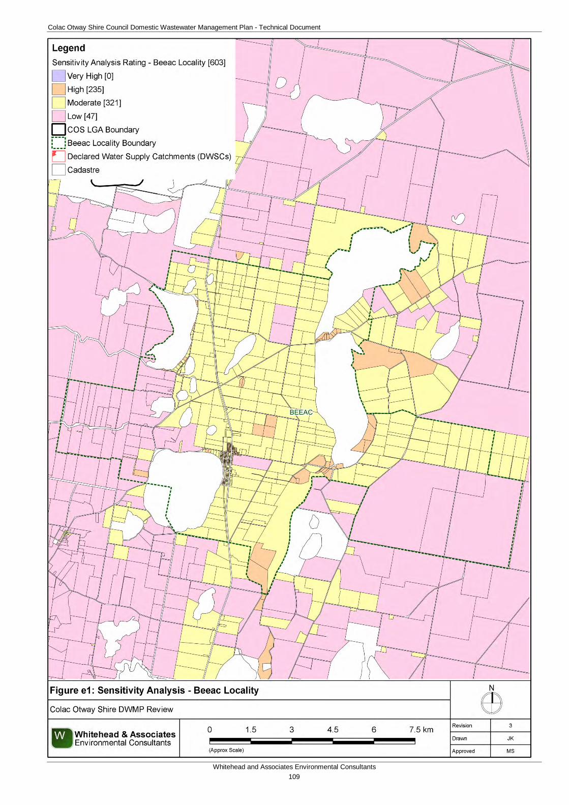
Colac Otway Shire Council Domestic Wastewater Management Plan - Technical Document
Whitehead and Associates Environmental Consultants 109
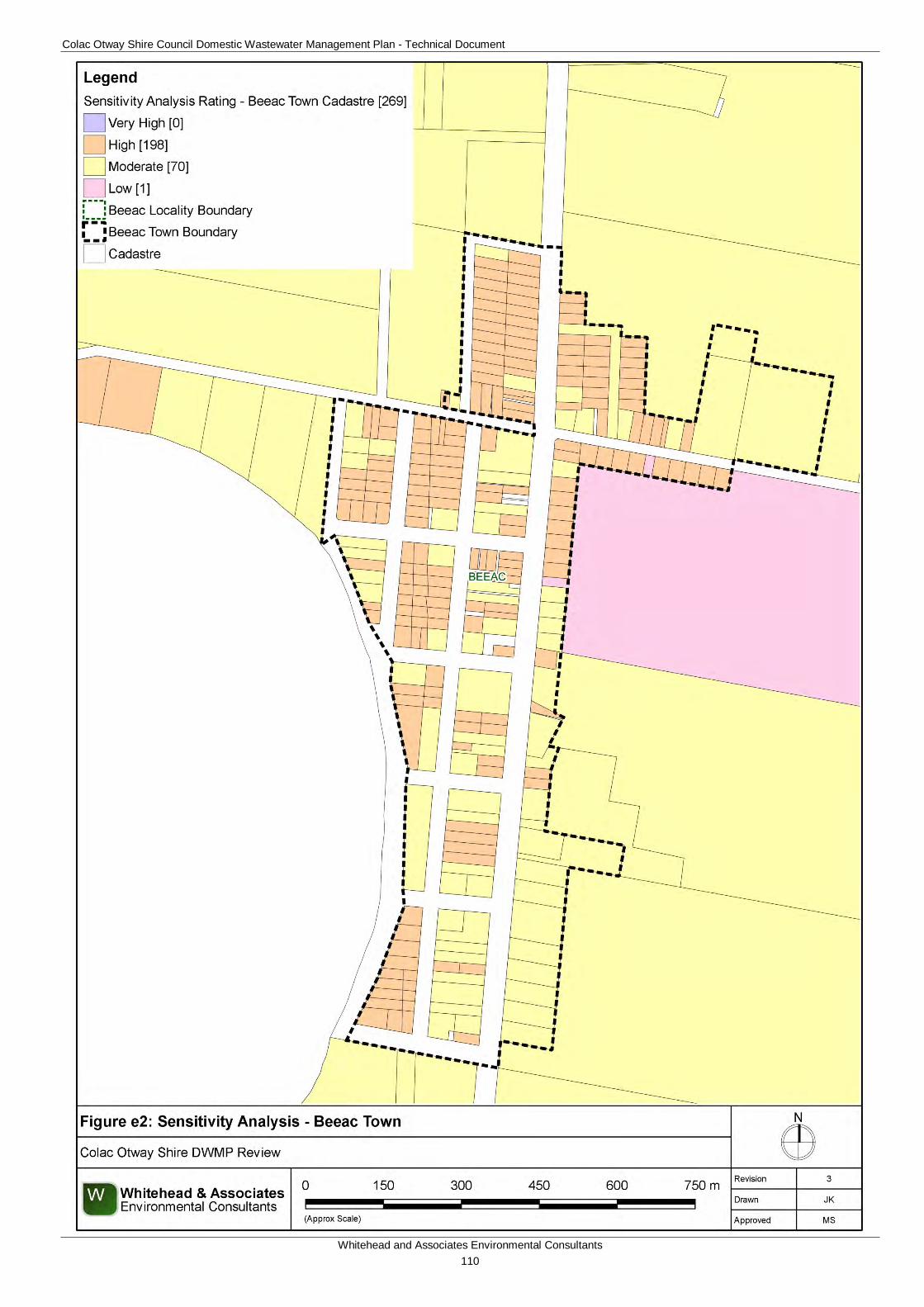
Colac Otway Shire Council Domestic Wastewater Management Plan - Technical Document
Whitehead and Associates Environmental Consultants 110
Colac Otway Shire Council Domestic Wastewater Management Plan - Technical Document
Whitehead and Associates Environmental Consultants 111
5e. System Selection Due to the dominance of heavy-textured soils in the Beeac locality, conventional absorption trenches and beds are not likely to be feasible and are discouraged. Appendix A of the EPA Code of Practice (2013) prohibits LPED systems on Category 5 and 6 soils (medium to heavy clays). The System Sizing Tables (below) indicate which systems are likely to be the most appropriate for the locality.
6e. System Sizing Tables Sizing Tables for each system type were created using conservative monthly water balances, following methods described in the MAV Model LCA, 2014. The water balances used monthly 70th percentile rainfall and average evapotranspiration data for Alvie, as it was compared with that of Beeac and found to be very similar, with very little size differences in water balance results. The climate data for Alvie was sourced from SILO (Scientific Information for Land Owners) climate databases, which are managed by the Queensland Government. The SILO databases use accurate meteorological data collected throughout Australia over long time periods.
The Design Loading Rates (DLRs) and Design Irrigation Rates (DIRs) were taken from the current EPA Code of Practice. Where the Code of Practice has precluded use of a particular type of system on a certain soil type, it is shown as ‘Not Applicable’ for that soil type in the Sizing Tables. Where the evapotranspiration deficit requires unrealistically large land application areas for a particular system on a certain soil type, it is also shown as ‘Not Applicable’ for that soil type in the Sizing Tables. Detailed, site-specific LCAs and system designs would be required to further investigate the feasibility of systems deemed ‘Not Applicable’ in the sizing tables. Mitigation measures (such as importation of topsoil to appropriate depths in the land application area), may be required to sustainably achieve land application of effluent on constrained properties/parcels.
Sizing Tables for the Beeac locality are provided below.
7e. General Conclusion The Sensitivity Rating with regards to sustainable DWM varied throughout the Beeac locality. Council, Standard and Detailed LCAs will be required, with the use of the Sizing Tables deemed appropriate except for the Detailed LCA which requires site-specific design. Particular attention needs to be directed towards ensuring that systems are sized based on the most limiting soil horizon, that the amenity of the Lakes is maintained, that the minimum depth from the base of the land application area and the watertable are maintained, and that DWM system components and land application areas are constructed above the COS Planning Schemes land subject to inundation overlay.
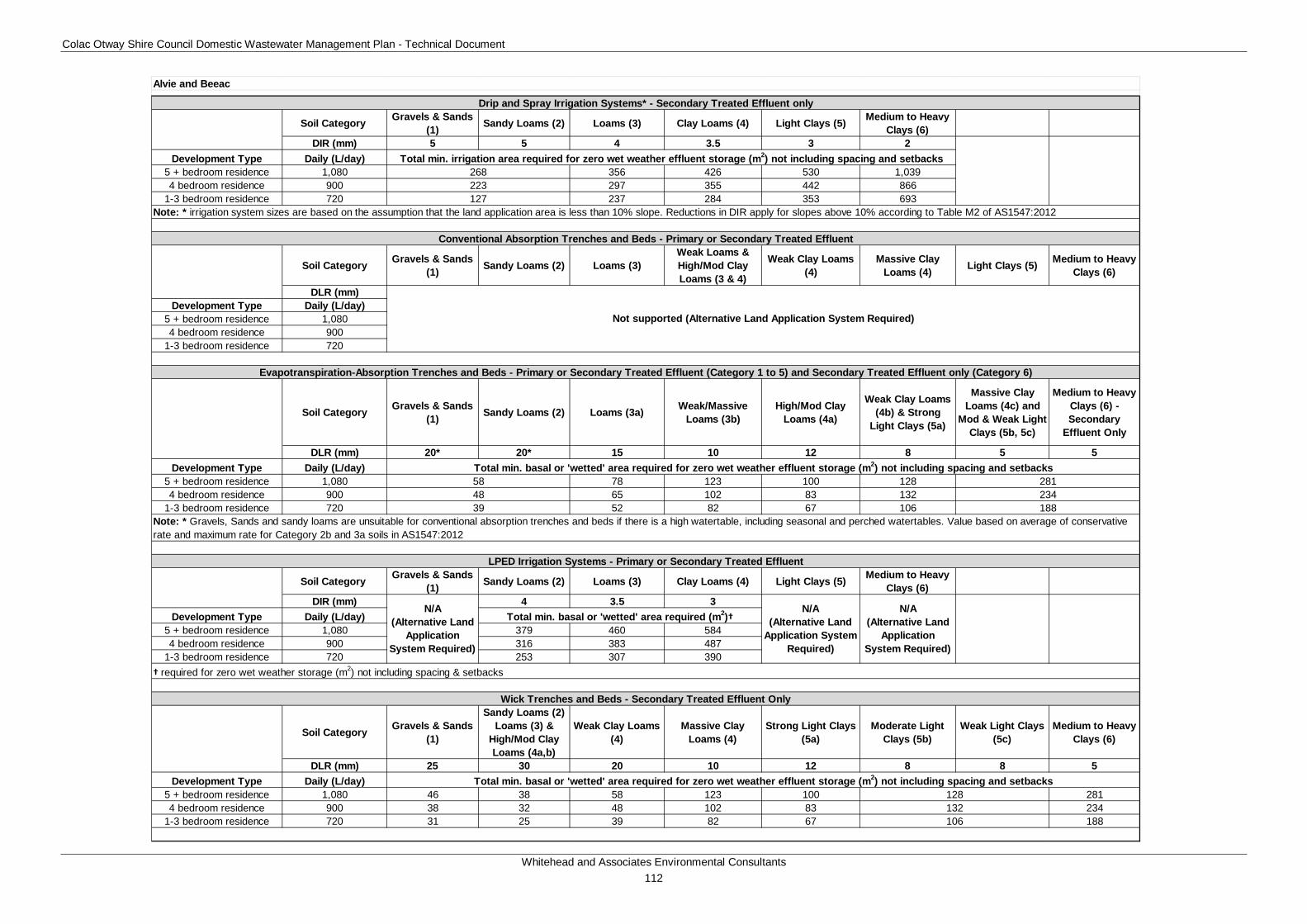
Colac Otway Shire Council Domestic Wastewater Management Plan - Technical Document
Whitehead and Associates Environmental Consultants 112
Soil Category Gravels & Sands (1) Sandy Loams (2) Loams (3) Clay Loams (4) Light Clays (5) Medium to Heavy
Clays (6)DIR (mm) 5 5 4 3.5 3 2
Development Type Daily (L/day)5 + bedroom residence 1,080 356 426 530 1,0394 bedroom residence 900 297 355 442 866
1-3 bedroom residence 720 237 284 353 693
Soil Category Gravels & Sands (1) Sandy Loams (2) Loams (3)
Weak Loams & High/Mod Clay Loams (3 & 4)
Weak Clay Loams (4)
Massive Clay Loams (4) Light Clays (5) Medium to Heavy
Clays (6)
DLR (mm)Development Type Daily (L/day)
5 + bedroom residence 1,0804 bedroom residence 900
1-3 bedroom residence 720
Soil Category Gravels & Sands (1) Sandy Loams (2) Loams (3a) Weak/Massive
Loams (3b)High/Mod Clay
Loams (4a)
Weak Clay Loams (4b) & Strong
Light Clays (5a)
Massive Clay Loams (4c) and
Mod & Weak Light Clays (5b, 5c)
Medium to Heavy Clays (6) - Secondary
Effluent Only
DLR (mm) 20* 20* 15 10 12 8 5 5Development Type Daily (L/day)
5 + bedroom residence 1,080 78 123 100 1284 bedroom residence 900 65 102 83 132
1-3 bedroom residence 720 52 82 67 106
Soil Category Gravels & Sands (1) Sandy Loams (2) Loams (3) Clay Loams (4) Light Clays (5) Medium to Heavy
Clays (6)DIR (mm) 4 3.5 3
Development Type Daily (L/day)5 + bedroom residence 1,080 379 460 5844 bedroom residence 900 316 383 487
1-3 bedroom residence 720 253 307 390
Soil Category Gravels & Sands (1)
Sandy Loams (2) Loams (3) &
High/Mod Clay Loams (4a,b)
Weak Clay Loams (4)
Massive Clay Loams (4)
Strong Light Clays (5a)
Moderate Light Clays (5b)
Weak Light Clays (5c)
Medium to Heavy Clays (6)
DLR (mm) 25 30 20 10 12 8 8 5Development Type Daily (L/day)
5 + bedroom residence 1,080 46 38 58 123 100 2814 bedroom residence 900 38 32 48 102 83 234
1-3 bedroom residence 720 31 25 39 82 67 188106
N/A (Alternative Land
Application System Required)
N/A (Alternative Land
Application System Required)
Wick Trenches and Beds - Secondary Treated Effluent Only
† required for zero wet weather storage (m2) not including spacing & setbacks
Note: * irrigation system sizes are based on the assumption that the land application area is less than 10% slope. Reductions in DIR apply for slopes above 10% according to Table M2 of AS1547:2012
Conventional Absorption Trenches and Beds - Primary or Secondary Treated Effluent
Not supported (Alternative Land Application System Required)
128132
Drip and Spray Irrigation Systems* - Secondary Treated Effluent only
Total min. basal or 'wetted' area required for zero wet weather effluent storage (m2) not including spacing and setbacks
Evapotranspiration-Absorption Trenches and Beds - Primary or Secondary Treated Effluent (Category 1 to 5) and Secondary Treated Effluent only (Category 6)
LPED Irrigation Systems - Primary or Secondary Treated Effluent
Total min. irrigation area required for zero wet weather effluent storage (m2) not including spacing and setbacks
5848
268223127
Note: * Gravels, Sands and sandy loams are unsuitable for conventional absorption trenches and beds if there is a high watertable, including seasonal and perched watertables. Value based on average of conservative rate and maximum rate for Category 2b and 3a soils in AS1547:2012
39
Alvie and Beeac
281234188
Total min. basal or 'wetted' area required (m2)†N/A
(Alternative Land Application System
Required)
Total min. basal or 'wetted' area required for zero wet weather effluent storage (m2) not including spacing and setbacks
Colac Otway Shire Council Domestic Wastewater Management Plan - Technical Document
Whitehead and Associates Environmental Consultants 113
F. Beech Forest Locality Report 1f. Introduction Beech Forest is located approximately 43km south of Colac on the northern edge of the Otway Ranges. The landform consists of rolling hills and crests of the Otway Ranges. Approximately half of the locality is located within a DWSC; with the northern region located within Gellibrand River DWSC and the southeast region located within Barham River DWSC. The main road through the town runs along a ridgeline that forms the DWSC boundary as indicated by the surface water informative map A1, Appendix A.
There are approximately 354 and 150 unsewered properties/parcels located within the Beech Forest locality and town, respectively, with 34 DWM system permits that have been inspected to date by COS. The current DWM permits and their associated treatment system and LAA method within the Beech Forest locality are summarised as follows:
• 7 AWTS (1 irrigation, 3 drip irrigation, 2 trenches, and 1 unknown);
• 1 sand filter (1 drip irrigation);
• 12 septic tanks (4 trenches, 8 unknown);
• 1 worm farm (1 trench); and
• 13 unknown (6 trenches, 1 subsurface irrigation and 6 unknown).
2f. Background Documentation Refer to the following documents for additional detail regarding the locality:
• Beech Forest Township Master Plan Report (May, 2004);
• COS Planning Scheme; and
• Rural Living Strategy (2011).
3f. Site Assessment Results The following table summarises the results from the representative audits conducted by Consultant staff in September 2014.
Characteristic Description
Land use Beech Forest comprises a range of land uses, including dairy, forestry, rural living and tourism.
Occupancy rates 2.3 (Beech Forest State Suburb, ABS Census, 2011).
Typical soils
Gradational profile of dark grey brown sandy clay loam grading to dark brown silty clay loam between 10-25cm, grading to dark brown to dark reddish brown sandy clay loam with excellent structure and fairly common small rock fragments. Drainage and permeability are variable depending on slope and position.
AS/NZS 1547:2012 4 (Clay Loams) and 5 (Light Clays)
Colac Otway Shire Council Domestic Wastewater Management Plan - Technical Document
Whitehead and Associates Environmental Consultants 114
Characteristic Description
soil categories
Existing Systems
Separate Blackwater and Greywater
Of the six systems inspected during field investigations, just one (17%) comprised separate blackwater treatment in a septic tank, with direct greywater diversion to the ground surface within the property/parcel boundary.
The blackwater septic tank was 40+ years old and had been pumped out more than 15 years ago. Septic effluent discharged to one conventional absorption trench of approximately 3m length, on land of less than 4% slope and parallel with contours. There was no evidence of blackwater effluent surcharging to the surface. Soils were typically soft or boggy, mainly due to recent high rainfall.
Combined Blackwater and Greywater
Five of the six systems (83%) inspected had combined wastewater treatment systems or were assumed to have combined systems, based on layout of pipework and/or age of dwelling. One of these five systems is an Aerated Wastewater Treatment System (AWTS), for a commercial property. It is likely that the proportion of combined systems in Beech Forest is likely to be less than this; however, this should be confirmed by ongoing inspections by Council.
Septic tank effluent discharged to one or more conventional absorption trenches, or was assumed to when the LAA could not be identified. Generally trenches were undersized for the number of bedrooms or there was inadequate suitable space for an appropriately sized LAA.
The AWTS effluent discharged to a subsurface irrigation system of approximately 480m2.
4f. Summary of Constraints to DWM Characteristic Description
Climate Zone The town is included within Zone 4 and part of the surrounding locality is located within Zone 3.
Surface waterways & catchments
The northern half and the south-eastern corner of the locality are located within the Gellibrand River DWSC and Barham River DWSC, respectively. The DWSC boundary runs along the ridgeline, which forms the major road running through the middle of the town. The drainage network is extensive, with West Gellibrand Dam located in the northeast of the locality along the Gellibrand River.
Waterways located within the DWSC are: Asplin Creek, Larder Creek East and West Branches, Little Larder Creek, McDonald Creek, Charleys Creek, Barham River East Branch, Falls Creek, and Seaview
Colac Otway Shire Council Domestic Wastewater Management Plan - Technical Document
Whitehead and Associates Environmental Consultants 115
Characteristic Description
Creek.
Waterways located outside of the DWSC are: Aire River, Little Aire Creek, Youngs Creek, Corgram Creek, Farrell Creek, Beech Creek, and Deppeler Creek.
Groundwater Proximity to groundwater bores: minimal (only 3).
Land subject to inundation Nil.
Useable Lot Area
Town (Locality)
High: 98 (125)
Moderate: 39 (67)
Low: 13 (146)
Compliant: 0 (16)
Minimum lot size compliance with Planning Scheme Zoning
The locality is predominantly zoned Farming Zone to the west and Public Conservation and Resource Zone to the east. The town is zoned as Township Zone.
Compliancy is variable throughout the locality, with the smaller town properties/parcels generally compliant and the larger rural properties/parcels non-compliant.
Compliant: 147 (191)
Non-compliant: 3 (163)
Slope
Town (Locality)
High: 98 (229)
Moderate: 26 (64)
Low: 26 (61)
Geology Underlain by Eumeralla Formation of Otway Group which consist of fluvial and braided stream sedimentary deposits.
Soil suitability
Town (Locality)
High: 150 (302)
Moderate: 0 (52)
Low: 0 (0)
The central region of the locality, including the town, consists of soil landscape unit ‘60’ which form on rolling hills along the top of the Otway Ranges. The soil consists of brown friable gradational soils with weakly structured clay loam over light clay to 0.9m depth. Limitations include restricted drainage.
The remainder of the locality consists of soil landscape unit ‘61’ which forms on the deeply dissected hills of the Otway Ranges and consists of brown gradational soils to 1.2m depth. The soils consist of
Colac Otway Shire Council Domestic Wastewater Management Plan - Technical Document
Whitehead and Associates Environmental Consultants 116
Characteristic Description
moderately structured silty loam over clay loam. Limitations include acidity and restricted drainage.
Sensitivity Overlay
No depth to groundwater data.
Landslip: extensive around locality
Vegetation: both sides of ridgeline.
Sensitivity Analysis Rating
Town (Locality)
Very High: 103 (126)
High: 44 (162)
Moderate: 3 (66)
Low: 0 (0)
5f. Sensitivity Analysis (Maps)
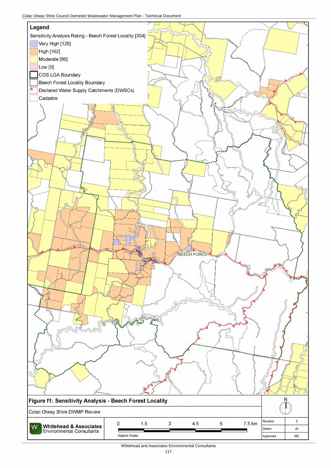
Colac Otway Shire Council Domestic Wastewater Management Plan - Technical Document
Whitehead and Associates Environmental Consultants 117
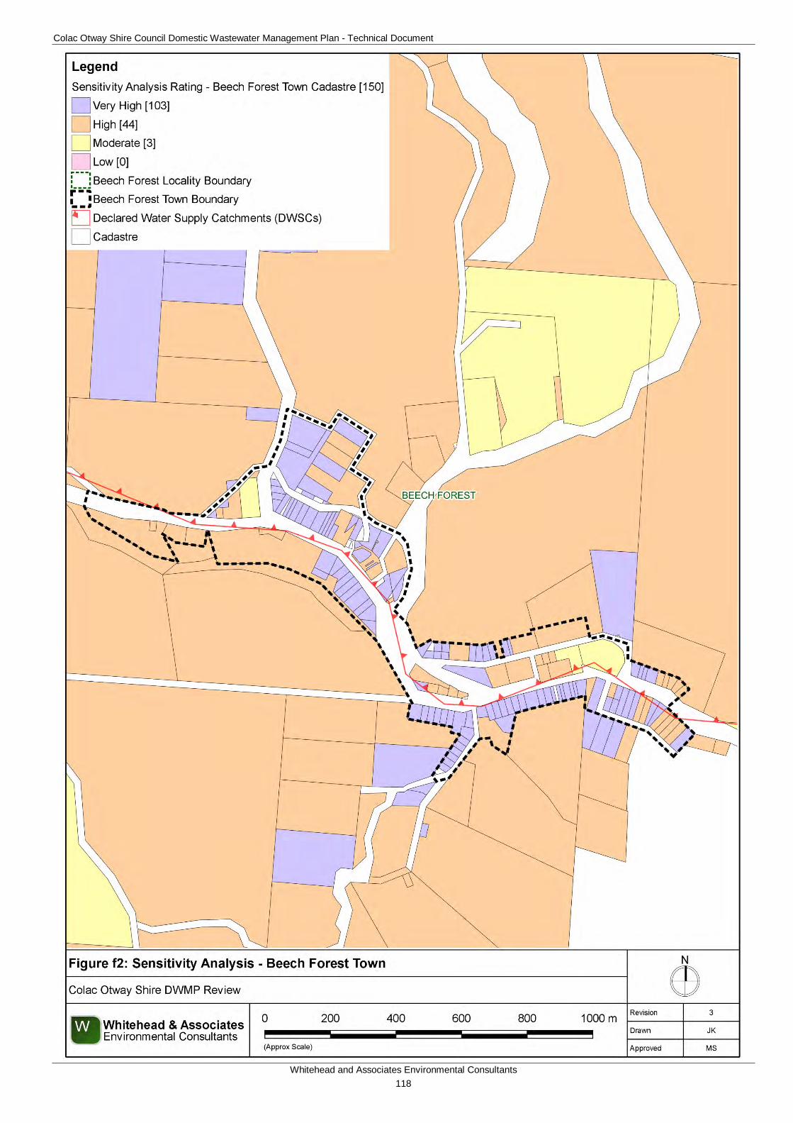
Colac Otway Shire Council Domestic Wastewater Management Plan - Technical Document
Whitehead and Associates Environmental Consultants 118
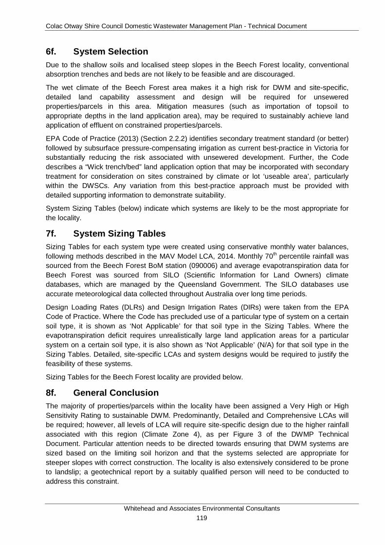
Colac Otway Shire Council Domestic Wastewater Management Plan - Technical Document
Whitehead and Associates Environmental Consultants 119
6f. System Selection Due to the shallow soils and localised steep slopes in the Beech Forest locality, conventional absorption trenches and beds are not likely to be feasible and are discouraged.
The wet climate of the Beech Forest area makes it a high risk for DWM and site-specific, detailed land capability assessment and design will be required for unsewered properties/parcels in this area. Mitigation measures (such as importation of topsoil to appropriate depths in the land application area), may be required to sustainably achieve land application of effluent on constrained properties/parcels.
EPA Code of Practice (2013) (Section 2.2.2) identifies secondary treatment standard (or better) followed by subsurface pressure-compensating irrigation as current best-practice in Victoria for substantially reducing the risk associated with unsewered development. Further, the Code describes a “Wick trench/bed” land application option that may be incorporated with secondary treatment for consideration on sites constrained by climate or lot ‘useable area’, particularly within the DWSCs. Any variation from this best-practice approach must be provided with detailed supporting information to demonstrate suitability.
System Sizing Tables (below) indicate which systems are likely to be the most appropriate for the locality.
7f. System Sizing Tables Sizing Tables for each system type were created using conservative monthly water balances, following methods described in the MAV Model LCA, 2014. Monthly 70th percentile rainfall was sourced from the Beech Forest BoM station (090006) and average evapotranspiration data for Beech Forest was sourced from SILO (Scientific Information for Land Owners) climate databases, which are managed by the Queensland Government. The SILO databases use accurate meteorological data collected throughout Australia over long time periods.
Design Loading Rates (DLRs) and Design Irrigation Rates (DIRs) were taken from the EPA Code of Practice. Where the Code has precluded use of a particular type of system on a certain soil type, it is shown as ‘Not Applicable’ for that soil type in the Sizing Tables. Where the evapotranspiration deficit requires unrealistically large land application areas for a particular system on a certain soil type, it is also shown as ‘Not Applicable’ (N/A) for that soil type in the Sizing Tables. Detailed, site-specific LCAs and system designs would be required to justify the feasibility of these systems.
Sizing Tables for the Beech Forest locality are provided below.
8f. General Conclusion The majority of properties/parcels within the locality have been assigned a Very High or High Sensitivity Rating to sustainable DWM. Predominantly, Detailed and Comprehensive LCAs will be required; however, all levels of LCA will require site-specific design due to the higher rainfall associated with this region (Climate Zone 4), as per Figure 3 of the DWMP Technical Document. Particular attention needs to be directed towards ensuring that DWM systems are sized based on the limiting soil horizon and that the systems selected are appropriate for steeper slopes with correct construction. The locality is also extensively considered to be prone to landslip; a geotechnical report by a suitably qualified person will need to be conducted to address this constraint.
Colac Otway Shire Council Domestic Wastewater Management Plan - Technical Document
Whitehead and Associates Environmental Consultants 120
Soil Category Gravels & Sands (1) Sandy Loams (2) Loams (3) Clay Loams (4) Light Clays (5) Medium to Heavy
Clays (6)DIR (mm)
Development Type Daily (L/day)
5 + bedroom residence 1,0804 bedroom residence 900
1-3 bedroom residence 720
† not including spacing or setbacks
Soil Category Gravels & Sands (1) Sandy Loams (2) Loams (3)
Weak Loams & High/Mod Clay Loams (3 & 4)
Weak Clay Loams (4) Light Clays (5) Massive Clay
Loams (4)Medium to Heavy
Clays (6)
DLR (mm)Development Type Daily (L/day)
5 + bedroom residence 1,0804 bedroom residence 900
1-3 bedroom residence 720
Soil Category Gravels & Sands (1) Sandy Loams (2) Loams (3a) Weak/Massive
Loams (3b)High/Mod Clay
Loams (4a)
Weak Clay Loams (4b) & Strong
Light Clays (5a)
Massive Clay Loams (4c) and
Mod & Weak Light Clays (5b, 5c)
Medium to Heavy Clays (6) - Secondary
Effluent Only
DLR (mm) 20* 20* 15 10 12 8Development Type Daily (L/day)
5 + bedroom residence 1,080 131 332 206 862**4 bedroom residence 900 110 277 172 719**
1-3 bedroom residence 720 88 222 138 575**
† will require detailed hydraulic design for effluent distribution system.
Soil Category Gravels & Sands (1) Sandy Loams (2) Loams (3) Clay Loams (4) Light Clays (5) Medium to Heavy
Clays (6)DIR (mm)
Development Type Daily (L/day)5 + bedroom residence 1,0804 bedroom residence 900
1-3 bedroom residence 720
Soil Category Gravels & Sands (1)
Sandy Loams (2) Loams (3) &
High/Mod Clay Loams (4a,b)
Weak Clay Loams (4)
Massive Clay Loams (4)
Strong Light Clays (5a)
Moderate Light Clays (5b)
Weak Light Clays (5c)
Medium to Heavy Clays (6)
DLR (mm) 25 30 20 10 12 8 8Development Type Daily (L/day)
5 + bedroom residence 1,080 81 311 1984 bedroom residence 900 67 260 165
1-3 bedroom residence 720 54 208 132Notes: ** Will require specialist advice regarding engineering and construction detail for installation.
Notes: * irrigation system sizes are based on the assumption that the land application area is less than 10% slope. Reductions in DIR apply for slopes above 10% according to Table M2 of AS1547:2012
Beech Forest (including Ferguson and Weeaproinah)
Drip and Spray Irrigation Systems* - Secondary Treated Effluent only
Not supported (Alternative Land Application System or Extensive/Modified Design Required)
Notes: * Gravels, Sands and Sandy loams are generally unsuitable for ETA trenches and beds if there is a high watertable, including seasonal and perched watertables. Value based on average of conservative rate and maximum rate for Category 2b and 3a soils in AS1547:2012. ** Will require specialist advice regarding engineering and construction detail for installation.
Conventional Absorption Trenches and Beds - Primary Treated Effluent
Not supported (Alternative Land Application System Required)
Evapotranspiration-Absorption Trenches and Beds† - Primary Treated Effluent (Category 3a to 5a) only
N/A (Alternative Land
Application System Required)
N/A (Alternative Land
Application System Required)
Total min. basal or 'wetted area' required for water balance (m2) not including spacing & setbacks
Not Supported (not considered best-practice)
611**489**
† will require detailed hydraulic design for effluent distribution system.
LPED Irrigation Systems - Primary or Secondary Treated Effluent
Not supported (Alternative Land Application System Required)
Wick Trench† - Secondary Treated Effluent Only
N/A (Alternative Land
Application System Required)
Total min. basal or 'wetted area' required for water balance (m2) not including spacing & setbacks
Not Supported (not considered best-practice)
734**
Colac Otway Shire Council Domestic Wastewater Management Plan - Technical Document
Whitehead and Associates Environmental Consultants 121
G. Carlisle River Locality Report 1g. Introduction Carlisle River is, spatially, the largest locality and is located approximately 30km southwest of Colac. The landform consists of dissected hills abutting rivers and streams and alluvial terraces with relatively flat topography in the dissected uplands of the Otway Ranges. Notably, the majority of the locality is located within a DWSC.
There are approximately 250 and 26 unsewered properties/parcels located within Carlisle River locality and town, respectively, with 25 DWM system permits that have been inspected to date by COS. The current DWM permits and their associated treatment system and LAA method within the Carlisle River locality are summarised as follows:
• 17 septic tanks (17 unknown); and
• 8 unknown (3 trenches, 5 unknown).
2g. Background Documentation Refer to the following documents for additional detail regarding the locality:
• Carlisle River Township Master Plan Report (February, 2004);
• COS Planning Scheme; and
• Rural Living Strategy (2011).
3g. Site Assessment Results The following table summarises the results from the representative audits conducted by Consultant staff in September 2014.
Characteristic Description
Land use Comprises a range of land uses, including dairy, forestry, rural living and tourism.
Occupancy rates 2.3 (Part of Beech Forest State Suburb, ABS Census, 2011).
Typical soils
Duplex soil. Black silt loam with excellent structure to 40cm, very wet below 25cm, abruptly overlies strongly mottled yellow brown and grey light to medium stiff clay to 70+cm. Can include lenses of dark yellow brown and strong brown mottled coffee rock between 40-50cm. Drainage and permeability are variable depending on slope and position.
AS/NZS 1547:2012 soil categories 4 (Clay Loams), 5 (Light Clays) and 6 (Medium to Heavy Clays).
Existing Systems
Separate Blackwater and Greywater
Of the three systems inspected during field investigations, one (33%) comprised separate blackwater treatment in a septic tank, with direct greywater diversion to an adjacent paddock. The septic tank was not
Colac Otway Shire Council Domestic Wastewater Management Plan - Technical Document
Whitehead and Associates Environmental Consultants 122
Characteristic Description
accessible, as it was covered by a concrete slab. It had been pumped out within the last two years.
Septic effluent discharged to four conventional absorption trenches of 10m each, on slopes of less than 2%. Drainage was poor.
Combined Blackwater and Greywater
Two systems (67%) inspected have a combined wastewater treatment system, or were assumed to have based on layout of pipework and age of dwelling. The time since last pump-out was generally unknown (partly due to owner not being home to ascertain).
Septic effluent discharged to one or more conventional absorption trenches (or was assumed to if trenches could not be identified). The trench dimensions were generally unclear, and it is likely that they were undersized for the number of bedrooms. The majority of trenches or/and available LAAs were located on land of less than 2% slope and appeared to be parallel with contours.
4g. Summary of Constraints to DWM Characteristic Description
Climate Zone Predominantly within Zone 3.
Surface waterways & catchments
Located entirely within DWSCs, i.e. Gellibrand River and Gellibrand River (South Otway). Two major rivers transverse the locality; Gellibrand River north to south in the western region of the locality and Carlisle River to the north of the town. Other waterways include: Rusty Creek, Sandy Creek, Crinoline Creek, Leahy Creek, Arkins Creek, Boggy Creek, and Charley Creek.
Groundwater Proximity to groundwater bores: located within the town and along the Gellibrand River and Carlisle River.
Land subject to inundation
Along northern and western boundaries associated with Gellibrand River and lower reaches of the Carlisle River confluence point.
Useable lot area
Town (Locality)
High: 10 (41)
Moderate: 5 (16)
Low: 11 (170)
Compliant: 0 (23)
Minimum lot size compliance with Planning Scheme Zoning
The locality is predominantly zoned Farming Zone and Public Conservation and Resource Zone. The town is zoned Township Zone.
Compliancy is variable throughout the locality, with all of the
Colac Otway Shire Council Domestic Wastewater Management Plan - Technical Document
Whitehead and Associates Environmental Consultants 123
Characteristic Description
properties/parcels within the town compliant.
Compliant: 26 (99)
Non-compliant: 0 (151)
Slope
Town (Locality)
High: 0 (121)
Moderate: 0 (32)
Low: 26 (97)
Geology Predominately underlain by the Wiridjil Gravel Member of the Pebble Point Formation, which is comprised of fluvial and braided stream deposits.
Moomowroong Sand Member of the Pebble Point Formation (marginal marine and beach deposits) is located near the town straddling unnamed alluvial floodplain deposits.
East to southeast - Eumeralla Formation of the Otway group which is comprised of fluvial and braided stream deposits.
Soil suitability
Town (Locality)
High: 00 (44)
Moderate: 26 (206)
Low: 0 (0)
Variable soil landscapes throughout the locality (7-8 in total).
The town consists of soil landscape unit ‘94’ which forms on elevated, and in parts, uplifted and dissected system of ancient cut and depositional terraces of Gellibrand River. The soils consist of grey sand soils with structured clay underneath; strongly structured sandy loam over moderately structured medium clay; to depths of more than 2m. Limitations include low fertility and restricted drainage.
The area adjacent to the river consists of soil landscape unit ‘61’ which forms on the deeply dissected hills of the Otway Ranges and consists of brown gradational soils to 1.2m depth. The soils consist of moderately structured silty loam over clay loam. Limitations include acidity and restricted drainage.
Sensitivity Overlay
Depth to Groundwater Compliance: variable compliancy, but generally compliant, except around the Gellibrand River and the confluence of Carlisle River.
Landslip: minimal
Vegetation: significant Great Otway National Park and Otway Forest Park.
Sensitivity Very High: 0 (0)

Colac Otway Shire Council Domestic Wastewater Management Plan - Technical Document
Whitehead and Associates Environmental Consultants 124
Characteristic Description
Analysis Rating
Town (Locality)
High: 0 (38)
Moderate: 26 (209)
Low: 0 (3)
5g. Sensitivity Analysis (Maps)
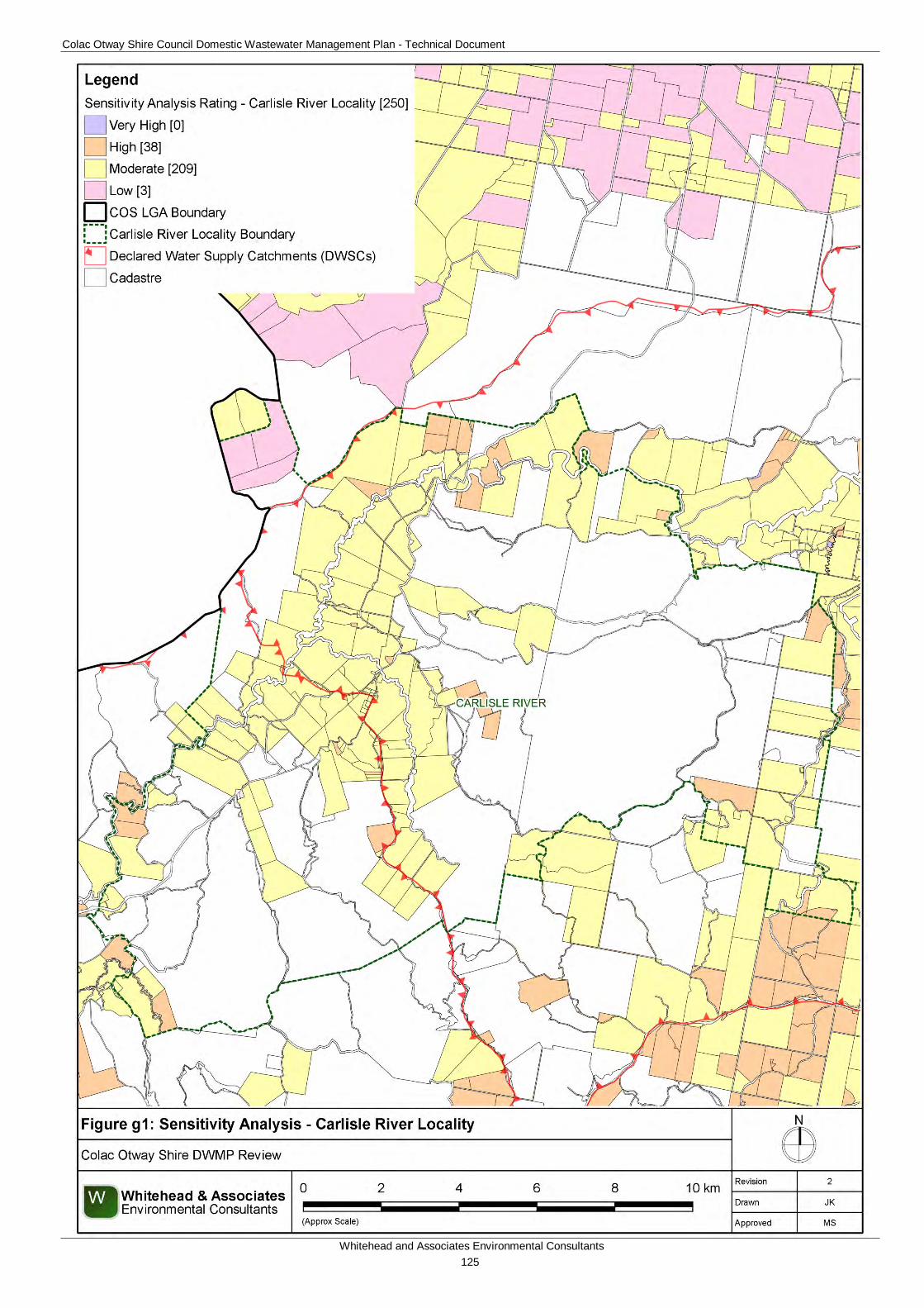
Colac Otway Shire Council Domestic Wastewater Management Plan - Technical Document
Whitehead and Associates Environmental Consultants 125
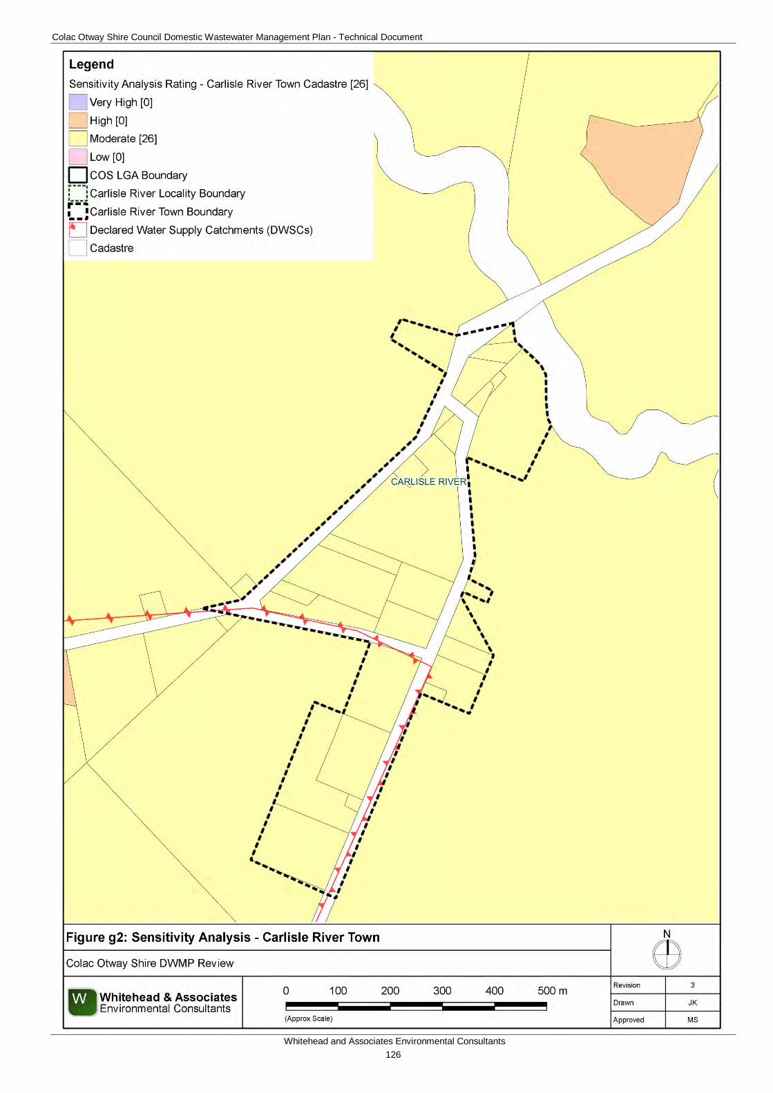
Colac Otway Shire Council Domestic Wastewater Management Plan - Technical Document
Whitehead and Associates Environmental Consultants 126
Colac Otway Shire Council Domestic Wastewater Management Plan - Technical Document
Whitehead and Associates Environmental Consultants 127
6g. System Selection Due to the dominance of heavy-textured soils in the Carlisle River locality, conventional absorption trenches and beds are not likely to be feasible and are discouraged. Appendix A of the EPA Code of Practice (2013) prohibits LPED systems on Category 5 and 6 soils (medium to heavy clays).
EPA Code of Practice (2013) (Section 2.2.2) identifies secondary treatment standard (or better) followed by subsurface pressure-compensating irrigation as current best-practice in Victoria for substantially reducing the risk associated with unsewered development. Further, the Code describes a “Wick trench/bed” land application option that may be incorporated with secondary treatment for consideration on sites constrained by climate or lot ‘useable area’, particularly within the DWSCs. Any variation from this best-practice approach must be provided with detailed supporting information to demonstrate suitability.
System Sizing Tables (below) indicate which systems are likely to be the most appropriate for the locality.
7g. System Sizing Tables Sizing Tables for each system type were created using conservative monthly water balances, following methods described in the MAV Model LCA, 2014. Monthly 70th percentile rainfall and average evapotranspiration data for Carlisle River was sourced from SILO (Scientific Information for Land Owners) climate databases, which are managed by the Queensland Government. The SILO databases use accurate meteorological data collected throughout Australia over long time periods.
The Design Loading Rates (DLRs) and Design Irrigation Rates (DIRs) were taken from the current EPA Code of Practice. Where the Code of Practice has precluded use of a particular type of system on a certain soil type, it is shown as ‘Not Applicable’ for that soil type in the Sizing Tables. Where the evapotranspiration deficit requires unrealistically large land application areas for a particular system on a certain soil type, it is also shown as ‘Not Applicable’ for that soil type in the Sizing Tables. Detailed, site-specific LCAs and system designs would be required to further investigate the feasibility of systems deemed ‘Not Applicable’ in the sizing tables. Mitigation measures (such as importation of topsoil to appropriate depths in the land application area), may be required to sustainably achieve land application of effluent on constrained properties/parcels.
Sizing Tables for the Carlisle River locality are provided below.
8g. General Conclusion The properties/parcels within Carlisle River, including the town, have predominantly been assigned a Moderate Sensitivity Rating to sustainable DWM. Predominantly, Standard LCAs will be required, with the use of System Sizing Tables deemed appropriate. The Low Sensitivity Rating properties/parcels within a DWSC are required to complete a Standard LCA as per the current EPA Code of Practice’s requirements. Particular attention needs to be directed towards ensuring that appropriate setbacks to surface waterways and groundwater bores are maintained, that the DWM systems are sized based on the limiting soil horizon, and that the degree of slope is taken into consideration when designing the LAA.
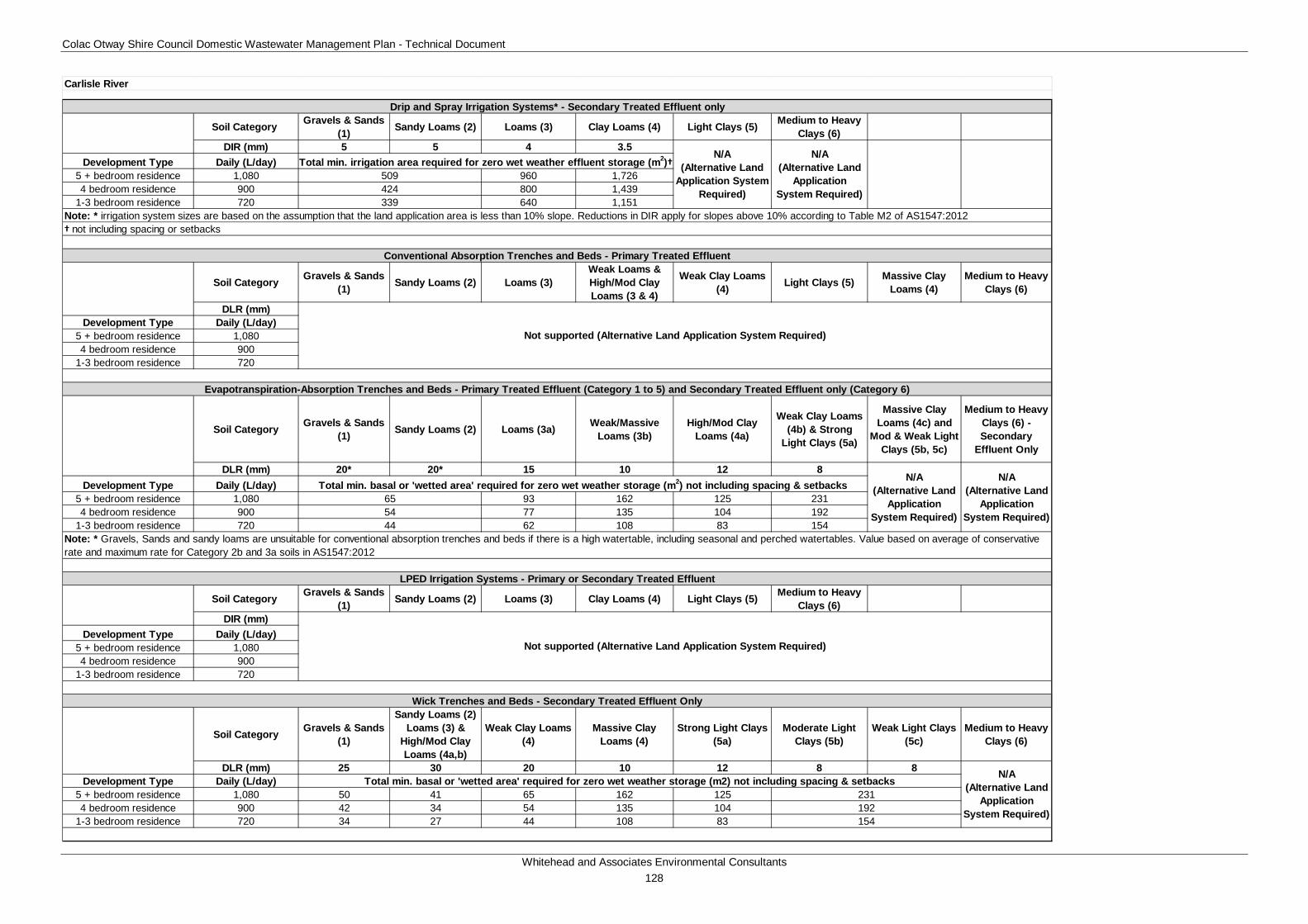
Colac Otway Shire Council Domestic Wastewater Management Plan - Technical Document
Whitehead and Associates Environmental Consultants 128
Soil Category Gravels & Sands (1) Sandy Loams (2) Loams (3) Clay Loams (4) Light Clays (5) Medium to Heavy
Clays (6)DIR (mm) 5 5 4 3.5
Development Type Daily (L/day)5 + bedroom residence 1,080 960 1,7264 bedroom residence 900 800 1,439
1-3 bedroom residence 720 640 1,151
† not including spacing or setbacks
Soil Category Gravels & Sands (1) Sandy Loams (2) Loams (3)
Weak Loams & High/Mod Clay Loams (3 & 4)
Weak Clay Loams (4) Light Clays (5) Massive Clay
Loams (4)Medium to Heavy
Clays (6)
DLR (mm)Development Type Daily (L/day)
5 + bedroom residence 1,0804 bedroom residence 900
1-3 bedroom residence 720
Soil Category Gravels & Sands (1) Sandy Loams (2) Loams (3a) Weak/Massive
Loams (3b)High/Mod Clay
Loams (4a)
Weak Clay Loams (4b) & Strong
Light Clays (5a)
Massive Clay Loams (4c) and
Mod & Weak Light Clays (5b, 5c)
Medium to Heavy Clays (6) - Secondary
Effluent Only
DLR (mm) 20* 20* 15 10 12 8Development Type Daily (L/day)
5 + bedroom residence 1,080 93 162 125 2314 bedroom residence 900 77 135 104 192
1-3 bedroom residence 720 62 108 83 154
Soil Category Gravels & Sands (1) Sandy Loams (2) Loams (3) Clay Loams (4) Light Clays (5) Medium to Heavy
Clays (6)DIR (mm)
Development Type Daily (L/day)5 + bedroom residence 1,0804 bedroom residence 900
1-3 bedroom residence 720
Soil Category Gravels & Sands (1)
Sandy Loams (2) Loams (3) &
High/Mod Clay Loams (4a,b)
Weak Clay Loams (4)
Massive Clay Loams (4)
Strong Light Clays (5a)
Moderate Light Clays (5b)
Weak Light Clays (5c)
Medium to Heavy Clays (6)
DLR (mm) 25 30 20 10 12 8 8Development Type Daily (L/day)
5 + bedroom residence 1,080 50 41 65 162 1254 bedroom residence 900 42 34 54 135 104
1-3 bedroom residence 720 34 27 44 108 83
Carlisle River
231192
Total min. basal or 'wetted area' required for zero wet weather storage (m2) not including spacing & setbacks
Not supported (Alternative Land Application System Required)
N/A (Alternative Land
Application System Required)
Wick Trenches and Beds - Secondary Treated Effluent Only
Conventional Absorption Trenches and Beds - Primary Treated Effluent
Note: * Gravels, Sands and sandy loams are unsuitable for conventional absorption trenches and beds if there is a high watertable, including seasonal and perched watertables. Value based on average of conservative rate and maximum rate for Category 2b and 3a soils in AS1547:2012
54
N/A (Alternative Land
Application System Required)
154
Not supported (Alternative Land Application System Required)
Drip and Spray Irrigation Systems* - Secondary Treated Effluent only
LPED Irrigation Systems - Primary or Secondary Treated Effluent
509424
Evapotranspiration-Absorption Trenches and Beds - Primary Treated Effluent (Category 1 to 5) and Secondary Treated Effluent only (Category 6)
N/A (Alternative Land
Application System Required)
Total min. irrigation area required for zero wet weather effluent storage (m2)†
Note: * irrigation system sizes are based on the assumption that the land application area is less than 10% slope. Reductions in DIR apply for slopes above 10% according to Table M2 of AS1547:2012339
44
N/A (Alternative Land
Application System Required)
N/A (Alternative Land
Application System Required)
65Total min. basal or 'wetted area' required for zero wet weather storage (m2) not including spacing & setbacks
Colac Otway Shire Council Domestic Wastewater Management Plan - Technical Document
Whitehead and Associates Environmental Consultants 129
H. Coragulac Locality Report 1h. Introduction Coragulac is a rural locality located approximately 13km northwest of Colac, in close proximity to the Cororooke and Alvie localities within the Red Rock region. The landform features undulating agricultural land on the Western Volcanic Plains.
There are approximately 201 and 69 unsewered properties/parcels located within the Coragulac locality and town, respectively, with 38 DWM system permits that have been inspected to date by COS. The current DWM permits and their associated treatment system and LAA method within the Coragulac locality are summarised as follows:
• 6 AWTS (3 subsurface irrigation and 3 drip irrigation);
• 1 sand filter (1 trench);
• 20 septic tanks (4 trenches and 16 unknown); and
• 11 unknown (2 trenches and 9 unknown).
No field investigations were conducted within the Coragulac locality as part of the 2014 field assessments.
2h. Background Documentation Refer to the following documents for additional detail regarding the locality:
• Red Rock Region Community Infrastructure Plan (September, 2013);
• COS Planning Scheme; and
• Rural Living Strategy (2011).
3h. Summary of Constraints to DWM Characteristic Description
Climate Zone Zone 2.
Surface waterways & catchments
Minimal surface waterways, with only Lake Coragulac and Lake Purdiguluc along the north-western locality border. Not located within a DWSC.
Groundwater Proximity to groundwater bores: distributed throughout the locality, similar to Cororooke.
Land subject to inundation Minimal; small amount to the west.
Useable lot area
Town (Locality)
High: 26 (41)
Moderate: 16 (33)
Low: 27 (125)
Compliant: 0 (2)
Colac Otway Shire Council Domestic Wastewater Management Plan - Technical Document
Whitehead and Associates Environmental Consultants 130
Characteristic Description
Minimum lot size compliance with Planning Scheme Zoning
The locality is predominantly zoned Farming Zone, with the town zoned Township Zone and Low Density Residential Zone.
Compliancy is variable throughout the locality, with the rural properties/parcels surrounding the town generally non-compliant.
Compliant: 60 (73)
Non-compliant: 9 (128)
Slope
Town (Locality)
High: 0 (1)
Moderate: 0 (2)
Low: 69 (198)
Geology Underlain by the Newer Volcanic Group with unnamed phreatomagmatic (tuff ring) deposits in the west (including the town) and unnamed stony rises and hummocky lava flows in the east.
Soil suitability
Town (Locality)
High: 0 (0)
Moderate: 69 (201)
Low: 0 (0)
The locality consists of soil landscape units ‘123’ and ‘114’ which form on gently undulating plains and stony rises of the Volcanic Western Plains. Soil type changes significantly with landform, but generally consists of moderately to strongly structured, friable clay loam over strongly structured medium clay to less than 1.5m depth. Limitations include restricted drainage.
Sensitivity Overlay
Depth to Groundwater Compliance: all compliant.
Landslip: Nil.
Vegetation: locality borders Lake Coragulac to the northwest.
Sensitivity Analysis Rating
Town (Locality)
Very High: 0 (0)
High: 0 (0)
Moderate: 42 (77)
Low: 27 (124)
4h. Sensitivity Analysis (Maps)
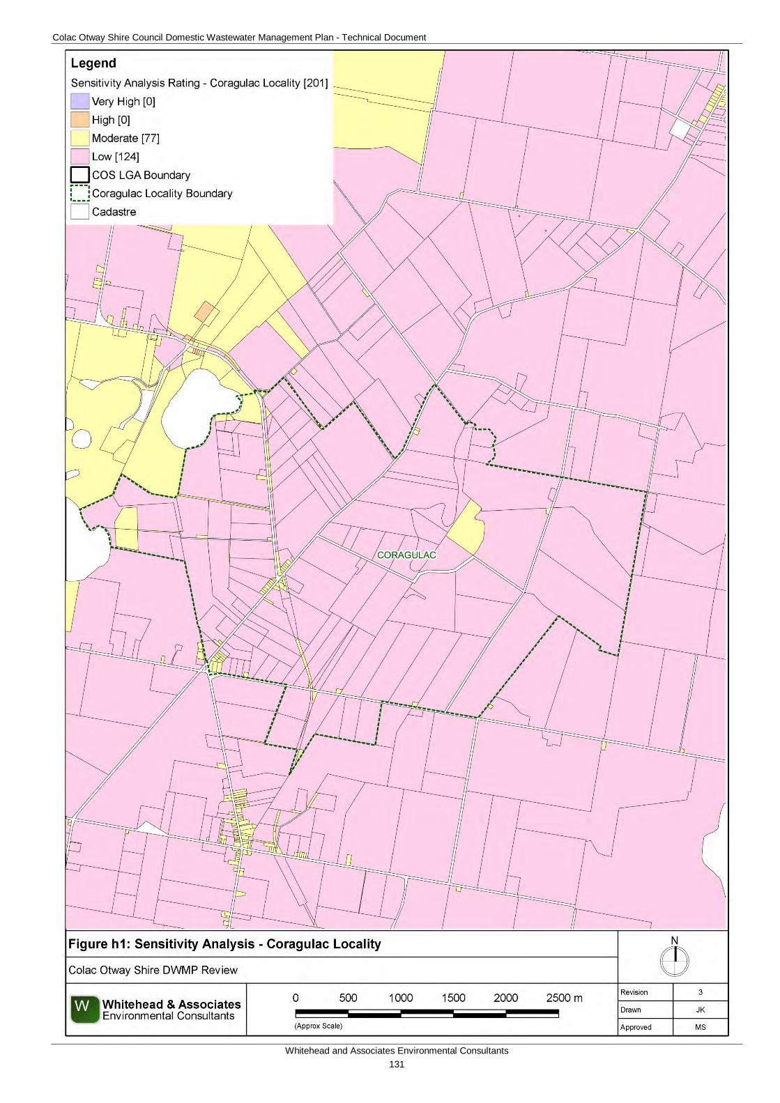
Colac Otway Shire Council Domestic Wastewater Management Plan - Technical Document
Whitehead and Associates Environmental Consultants 131
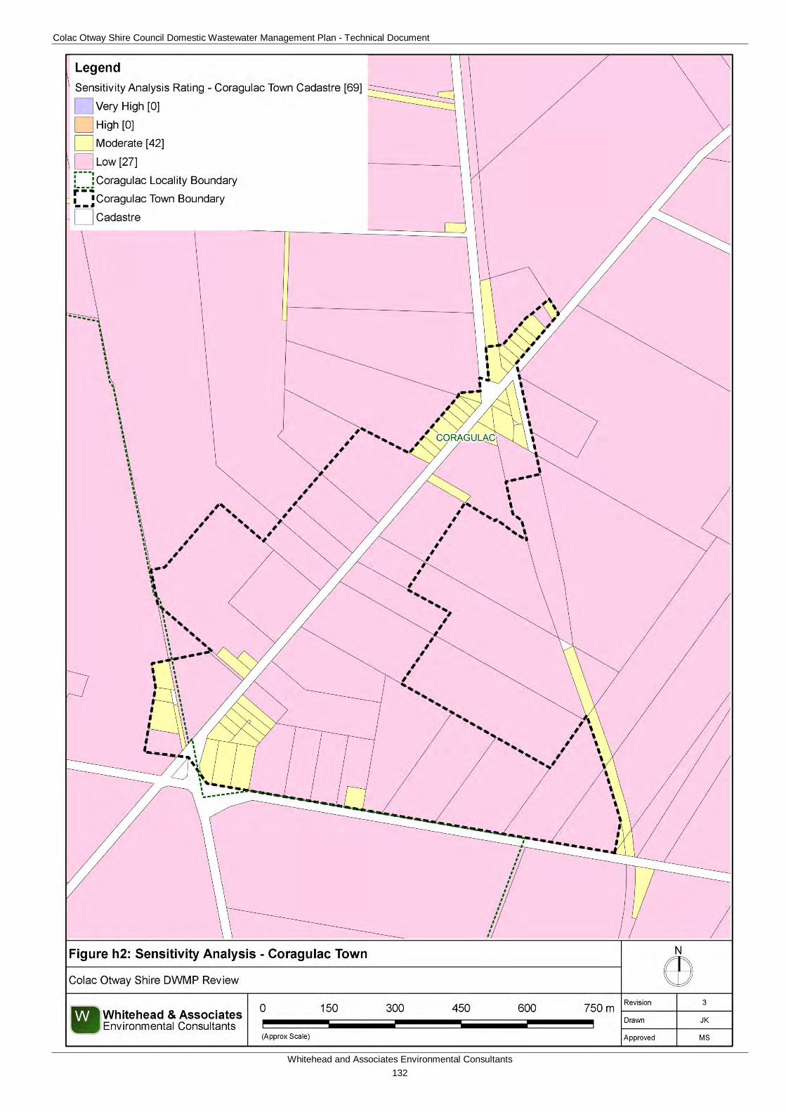
Colac Otway Shire Council Domestic Wastewater Management Plan - Technical Document
Whitehead and Associates Environmental Consultants 132
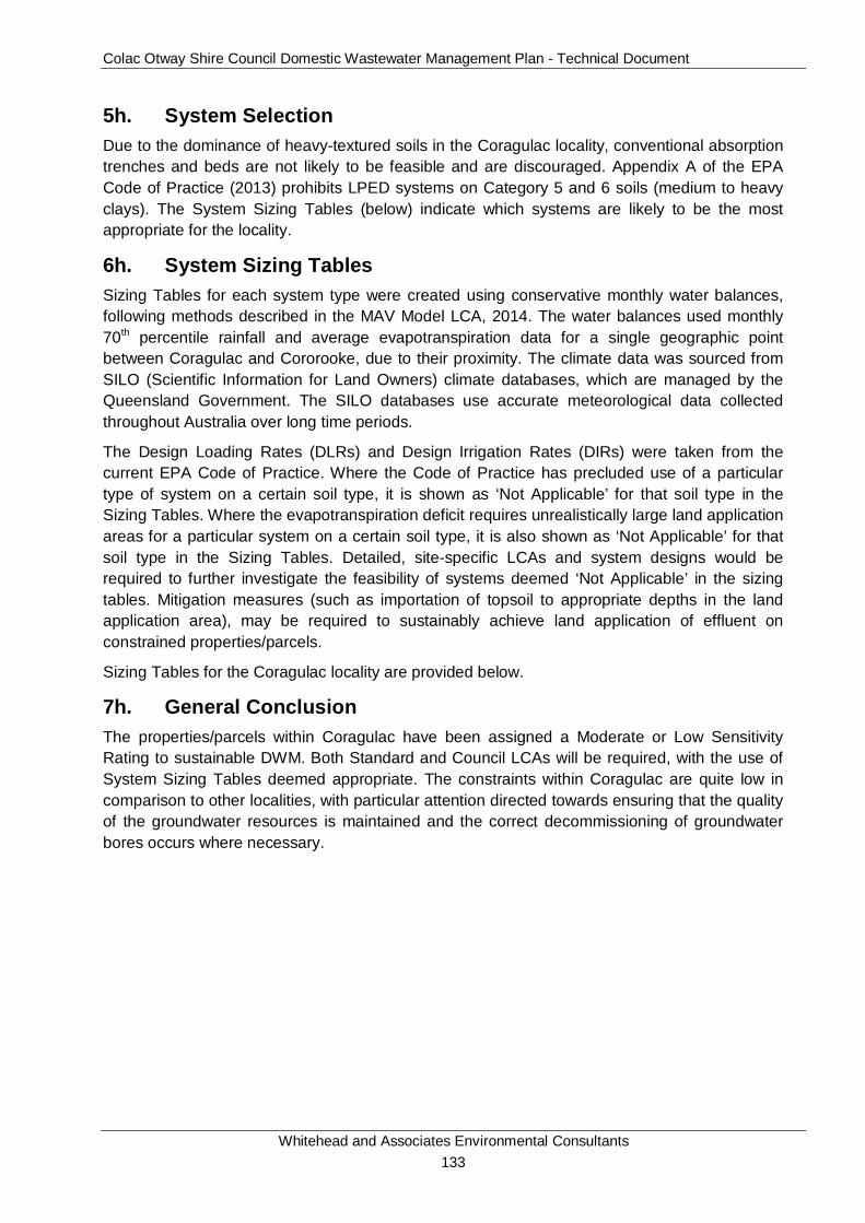
Colac Otway Shire Council Domestic Wastewater Management Plan - Technical Document
Whitehead and Associates Environmental Consultants 133
5h. System Selection Due to the dominance of heavy-textured soils in the Coragulac locality, conventional absorption trenches and beds are not likely to be feasible and are discouraged. Appendix A of the EPA Code of Practice (2013) prohibits LPED systems on Category 5 and 6 soils (medium to heavy clays). The System Sizing Tables (below) indicate which systems are likely to be the most appropriate for the locality.
6h. System Sizing Tables Sizing Tables for each system type were created using conservative monthly water balances, following methods described in the MAV Model LCA, 2014. The water balances used monthly 70th percentile rainfall and average evapotranspiration data for a single geographic point between Coragulac and Cororooke, due to their proximity. The climate data was sourced from SILO (Scientific Information for Land Owners) climate databases, which are managed by the Queensland Government. The SILO databases use accurate meteorological data collected throughout Australia over long time periods.
The Design Loading Rates (DLRs) and Design Irrigation Rates (DIRs) were taken from the current EPA Code of Practice. Where the Code of Practice has precluded use of a particular type of system on a certain soil type, it is shown as ‘Not Applicable’ for that soil type in the Sizing Tables. Where the evapotranspiration deficit requires unrealistically large land application areas for a particular system on a certain soil type, it is also shown as ‘Not Applicable’ for that soil type in the Sizing Tables. Detailed, site-specific LCAs and system designs would be required to further investigate the feasibility of systems deemed ‘Not Applicable’ in the sizing tables. Mitigation measures (such as importation of topsoil to appropriate depths in the land application area), may be required to sustainably achieve land application of effluent on constrained properties/parcels.
Sizing Tables for the Coragulac locality are provided below.
7h. General Conclusion The properties/parcels within Coragulac have been assigned a Moderate or Low Sensitivity Rating to sustainable DWM. Both Standard and Council LCAs will be required, with the use of System Sizing Tables deemed appropriate. The constraints within Coragulac are quite low in comparison to other localities, with particular attention directed towards ensuring that the quality of the groundwater resources is maintained and the correct decommissioning of groundwater bores occurs where necessary.
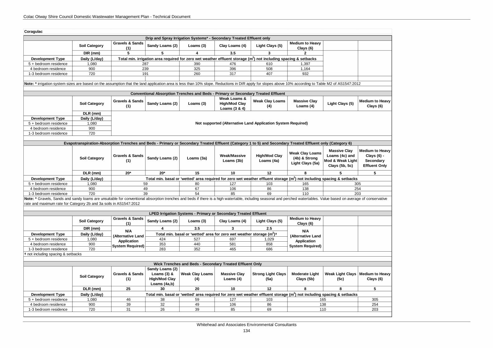
Colac Otway Shire Council Domestic Wastewater Management Plan - Technical Document
Whitehead and Associates Environmental Consultants 134
Soil Category Gravels & Sands (1) Sandy Loams (2) Loams (3) Clay Loams (4) Light Clays (5) Medium to Heavy
Clays (6)DIR (mm) 5 5 4 3.5 3 2
Development Type Daily (L/day)5 + bedroom residence 1,080 390 476 610 1,3974 bedroom residence 900 325 396 508 1,164
1-3 bedroom residence 720 260 317 407 932
Soil Category Gravels & Sands (1) Sandy Loams (2) Loams (3)
Weak Loams & High/Mod Clay Loams (3 & 4)
Weak Clay Loams (4)
Massive Clay Loams (4) Light Clays (5) Medium to Heavy
Clays (6)
DLR (mm)Development Type Daily (L/day)
5 + bedroom residence 1,0804 bedroom residence 900
1-3 bedroom residence 720
Soil Category Gravels & Sands (1) Sandy Loams (2) Loams (3a) Weak/Massive
Loams (3b)High/Mod Clay
Loams (4a)
Weak Clay Loams (4b) & Strong
Light Clays (5a)
Massive Clay Loams (4c) and
Mod & Weak Light Clays (5b, 5c)
Medium to Heavy Clays (6) - Secondary
Effluent Only
DLR (mm) 20* 20* 15 10 12 8 5 5Development Type Daily (L/day)
5 + bedroom residence 1,080 80 127 103 1654 bedroom residence 900 67 106 86 138
1-3 bedroom residence 720 54 85 69 110
Soil Category Gravels & Sands (1) Sandy Loams (2) Loams (3) Clay Loams (4) Light Clays (5) Medium to Heavy
Clays (6)DIR (mm) 4 3.5 3 2.5
Development Type Daily (L/day)5 + bedroom residence 1,080 424 527 697 1,0294 bedroom residence 900 353 440 581 858
1-3 bedroom residence 720 283 352 465 686
Soil Category Gravels & Sands (1)
Sandy Loams (2) Loams (3) &
High/Mod Clay Loams (4a,b)
Weak Clay Loams (4)
Massive Clay Loams (4)
Strong Light Clays (5a)
Moderate Light Clays (5b)
Weak Light Clays (5c)
Medium to Heavy Clays (6)
DLR (mm) 25 30 20 10 12 8 8 5Development Type Daily (L/day)
5 + bedroom residence 1,080 46 38 59 127 103 3054 bedroom residence 900 39 32 49 106 86 254
1-3 bedroom residence 720 31 26 39 85 69 203
Wick Trenches and Beds - Secondary Treated Effluent Only
39
Total min. irrigation area required for zero wet weather effluent storage (m2) not including spacing & setbacks
Total min. basal or 'wetted' area required for zero wet weather effluent storage (m2) not including spacing & setbacks
† not including spacing & setbacks
Total min. basal or 'wetted' area required for zero wet weather effluent storage (m2) not including spacing & setbacks
LPED Irrigation Systems - Primary or Secondary Treated Effluent
287239191
165
Drip and Spray Irrigation Systems* - Secondary Treated Effluent only
Note: * irrigation system sizes are based on the assumption that the land application area is less than 10% slope. Reductions in DIR apply for slopes above 10% according to Table M2 of AS1547:2012
Conventional Absorption Trenches and Beds - Primary or Secondary Treated Effluent
Note: * Gravels, Sands and sandy loams are unsuitable for conventional absorption trenches and beds if there is a high watertable, including seasonal and perched watertables. Value based on average of conservative rate and maximum rate for Category 2b and 3a soils in AS1547:2012
Total min. basal or 'wetted' area for zero wet weather storage (m2)†N/A
(Alternative Land Application
System Required)
N/A (Alternative Land
Application System Required)
Evapotranspiration-Absorption Trenches and Beds - Primary or Secondary Treated Effluent (Category 1 to 5) and Secondary Treated Effluent only (Category 6)
Coragulac
Not supported (Alternative Land Application System Required)
138110
305254203
5949
Colac Otway Shire Council Domestic Wastewater Management Plan - Technical Document
Whitehead and Associates Environmental Consultants 135
I. Cororooke Locality Report 1i. Introduction Cororooke is a rural locality located approximately 7km northwest of Colac in close proximity to the Coragulac and Alvie localities within the Red Rock region. The landform features undulating agricultural land on the Western Volcanic Plains.
There are approximately 301 and 112 unsewered properties/parcels located within the Cororooke locality and town, respectively, with 67 DWM system permits that have been inspected to date by COS. The current DWM permits and their associated treatment system and LAA method within the Cororooke locality are summarised as follows:
• 12 AWTS (5 drip irrigation, 1 irrigation, 1 trench and 5 unknown);
• 1 sand filter (1 drip irrigation);
• 41 septic tanks (3 trenches, 1 irrigation, 1 subsurface irrigation and 36 unknown); and
• 13 unknown (2 trenches and 11 unknown).
No field investigations were conducted in the Cororooke locality as part of the 2014 field assessments.
2i. Background Documentation Refer to the following documents for additional detail regarding the locality:
• Red Rock Region Community Infrastructure Plan (September, 2013);
• COS Planning Scheme; and
• Rural Living Strategy (2011).
3i. Summary of Constraints to DWM Characteristic Description
Climate Zone Zone 2.
Surface waterways & catchments
Located outside of a DWSC. Minimal drainage features, with Lake Colac to the east.
Groundwater Proximity to groundwater bores: distributed throughout the locality, similar to Coragulac.
Land subject to inundation Nil but extensive to the east (associated with Lake Colac).
Useable lot area
Town (Locality)
High: 69 (95)
Moderate: 26 (45)
Low: 17 (158)
Compliant: 0 (3)
Colac Otway Shire Council Domestic Wastewater Management Plan - Technical Document
Whitehead and Associates Environmental Consultants 136
Characteristic Description
Minimum lot size compliance with Planning Scheme Zoning
The locality is predominantly zoned Farming Zone. The town is zoned Township Zone and Rural Living Zone.
Compliancy is variable throughout the locality, with the majority of the rural properties/parcels non-compliant.
Compliant: 69 (77)
Non-compliant: 43 (224)
Slope
Town (Locality)
High: 0 (0)
Moderate: 0 (2)
Low: 112 (299)
Geology Variable.
The town is predominately underlain by unnamed stony rises and hummocky lava flows of the Newer Volcanic Group Transversing east-west.
North of the town – unnamed phreatomagmatic deposits (tuff rings) of Newer Volcanic Group
South of the town – Quaternary unnamed swamp, lake and estuarine deposits.
Southern region – Hanson Plain sand of the Brighton Group which is comprised of fluvial and minor shallow marine deposits
Along southern boundary – unnamed sheet flow basalt of the Newer Volcanic Group.
Soil suitability
Town (Locality)
High: 0 (14)
Moderate: 112 (287)
Low: 0 (0)
Variable throughout locality (6 in total).
The dominant soil landscape unit, which also includes the town, is ‘114’ which forms on gently undulating plains and stony rises of the Volcanic Western Plains. Soil type changes significantly with landform, but generally consists of moderately to strongly structured, friable clay loam over strongly structured medium clay to less than 1.5m depth. Limitations include restricted drainage.
Sensitivity Overlay
Depth to Groundwater Compliance: all compliant, including town, except for the eastern properties/parcels around Lake Colac.
Landslip: Nil
Vegetation: Lake Colac to southeast.

Colac Otway Shire Council Domestic Wastewater Management Plan - Technical Document
Whitehead and Associates Environmental Consultants 137
Characteristic Description
Final Sensitivity Rating
Town (Locality)
Very High: 0 (0)
High: 0 (0)
Moderate: 95 (153)
Low: 17 (148)
4i. Sensitivity Analysis (Maps)
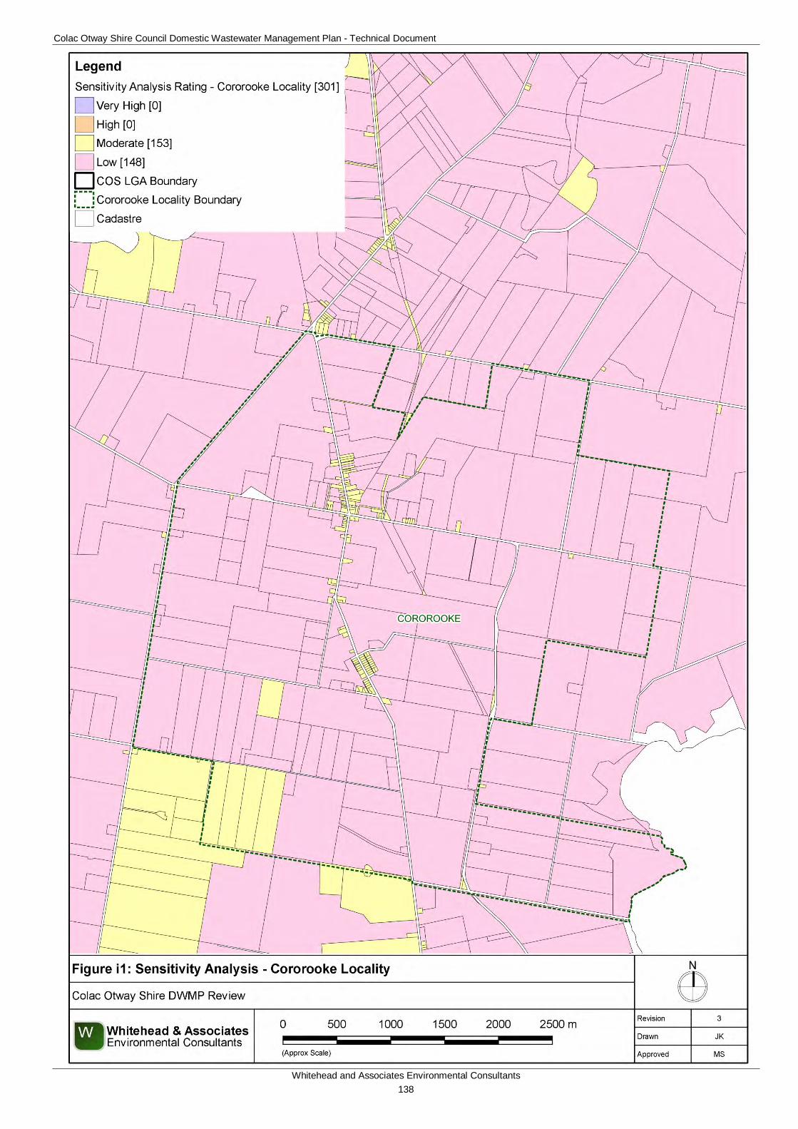
Colac Otway Shire Council Domestic Wastewater Management Plan - Technical Document
Whitehead and Associates Environmental Consultants 138
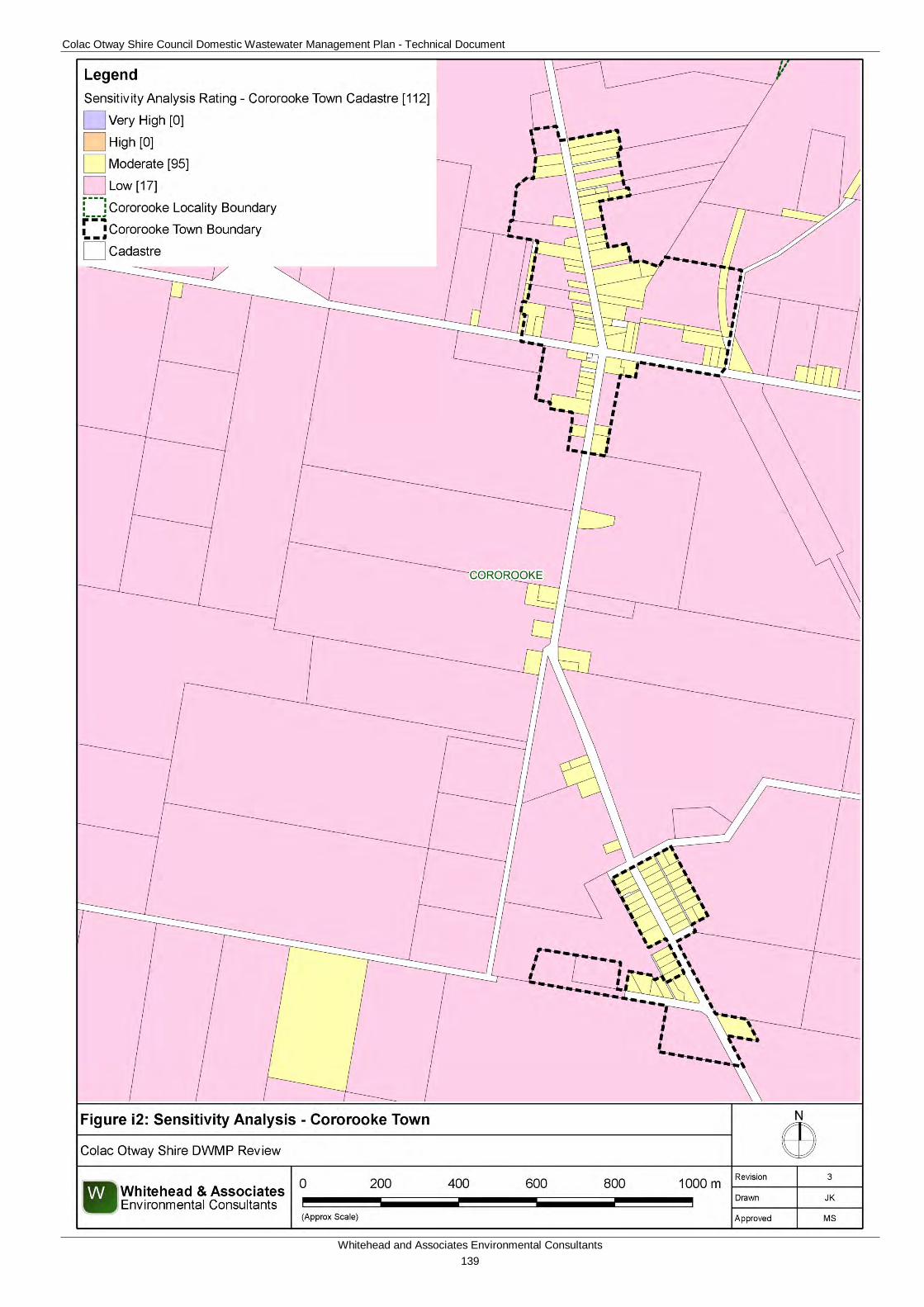
Colac Otway Shire Council Domestic Wastewater Management Plan - Technical Document
Whitehead and Associates Environmental Consultants 139
Colac Otway Shire Council Domestic Wastewater Management Plan - Technical Document
Whitehead and Associates Environmental Consultants 140
5i. System Selection Based on soil types and indicative depths, the Cororooke locality has the potential to sustainably accommodate a broad range of system types, depending on the influences of climate. The System Sizing Tables (below) indicate which systems are likely to be the most appropriate for the locality.
6i. System Sizing Tables Sizing Tables for each system type were created using conservative monthly water balances, following methods described in the MAV Model LCA, 2014. The water balances used monthly 70th percentile rainfall and average evapotranspiration data for a single geographic point between Cororooke and Coragulac, due to their proximity. The climate data was sourced from SILO (Scientific Information for Land Owners) climate databases, which are managed by the Queensland Government. The SILO databases use accurate meteorological data collected throughout Australia over long time periods.
The Design Loading Rates (DLRs) and Design Irrigation Rates (DIRs) were taken from the current EPA Code of Practice. Where the Code of Practice has precluded use of a particular type of system on a certain soil type, it is shown as ‘Not Applicable’ for that soil type in the Sizing Tables. Where the evapotranspiration deficit requires unrealistically large land application areas for a particular system on a certain soil type, it is also shown as ‘Not Applicable’ for that soil type in the Sizing Tables. Detailed, site-specific LCAs and system designs would be required to further investigate the feasibility of systems deemed ‘Not Applicable’ in the sizing tables. Mitigation measures (such as importation of topsoil to appropriate depths in the land application area), may be required to sustainably achieve land application of effluent on constrained properties/parcels.
Sizing Tables for the Cororooke locality are provided below.
7i. General Conclusion The properties/parcels within Cororooke have been assigned a Moderate or Low Sensitivity Rating to sustainable DWM. Both Standard and Council LCAs will be required, with the use of System Sizing Tables deemed appropriate. The constraints within Cororooke are quite low in comparison to other localities. Particular attention should be directed towards ensuring that the quality of the groundwater resources is maintained and the correct decommissioning of groundwater bores occurs where necessary.
Colac Otway Shire Council Domestic Wastewater Management Plan - Technical Document
Whitehead and Associates Environmental Consultants 141
Soil Category Gravels & Sands (1) Sandy Loams (2) Loams (3) Clay Loams (4) Light Clays (5) Medium to Heavy
Clays (6)DIR (mm) 5 5 4 3.5 3 2
Development Type Daily (L/day)5 + bedroom residence 1,080 390 476 610 1,3974 bedroom residence 900 325 396 508 1,164
1-3 bedroom residence 720 260 317 407 932
Soil Category Gravels & Sands (1) Sandy Loams (2) Loams (3)
Weak Loams & High/Mod Clay Loams (3 & 4)
Weak Clay Loams (4)
Massive Clay Loams (4) Light Clays (5) Medium to Heavy
Clays (6)
DLR (mm) 20* 20* 15 10 6 4 5Development Type Daily (L/day)
5 + bedroom residence 1,080 80 127 238 424 3054 bedroom residence 900 67 106 198 353 254
1-3 bedroom residence 720 54 85 159 283 203
Soil Category Gravels & Sands (1) Sandy Loams (2) Loams (3a) Weak/Massive
Loams (3b)High/Mod Clay
Loams (4a)
Weak Clay Loams (4b) & Strong
Light Clays (5a)
Massive Clay Loams (4c) and
Mod & Weak Light Clays (5b, 5c)
Medium to Heavy Clays (6) - Secondary
Effluent Only
DLR (mm) 20* 20* 15 10 12 8 5 5Development Type Daily (L/day)
5 + bedroom residence 1,080 80 127 103 1654 bedroom residence 900 67 106 86 138
1-3 bedroom residence 720 54 85 69 110
Soil Category Gravels & Sands (1) Sandy Loams (2) Loams (3) Clay Loams (4) Light Clays (5) Medium to Heavy
Clays (6)DIR (mm) 4 3.5 3 2.5
Development Type Daily (L/day)5 + bedroom residence 1,080 424 527 697 1,0294 bedroom residence 900 353 440 581 858
1-3 bedroom residence 720 283 352 465 686
Soil Category Gravels & Sands (1)
Sandy Loams (2) Loams (3) &
High/Mod Clay Loams (4a,b)
Weak Clay Loams (4)
Massive Clay Loams (4)
Strong Light Clays (5a)
Moderate Light Clays (5b)
Weak Light Clays (5c)
Medium to Heavy Clays (6)
DLR (mm) 25 30 20 10 12 8 8 5Development Type Daily (L/day)
5 + bedroom residence 1,080 46 38 59 127 103 3054 bedroom residence 900 39 32 49 106 86 254
1-3 bedroom residence 720 31 26 39 85 69 203
Cororooke
138110
4939
305254203
5949
Total min. basal or 'wetted' area for zero wet weather storage (m2)†N/A
(Alternative Land Application
System Required)
N/A (Alternative Land
Application System Required)
Evapotranspiration-Absorption Trenches and Beds - Primary or Secondary Treated Effluent (Category 1 to 5) and Secondary Treated Effluent only (Category 6)
165
Drip and Spray Irrigation Systems* - Secondary Treated Effluent only
Note: * irrigation system sizes are based on the assumption that the land application area is less than 10% slope. Reductions in DIR apply for slopes above 10% according to Table M2 of AS1547:2012
Conventional Absorption Trenches and Beds - Primary or Secondary Treated Effluent
Note: * Gravels, Sands and sandy loams are unsuitable for conventional absorption trenches and beds if there is a high watertable, including seasonal and perched watertables. Value based on average of conservative rate and maximum rate for Category 2b and 3a soils in AS1547:2012
Note: * Gravels, Sands and sandy loams are unsuitable for conventional absorption trenches and beds if there is a high watertable, including seasonal and perched watertables. Value based on average of conservative rate and maximum rate for Category 2b and 3a soils in AS1547:2012
Total min. irrigation area required for zero wet weather effluent storage (m2) not including spacing & setbacks
Total min. basal or 'wetted' area required for zero wet weather effluent storage (m2) not including spacing & setbacks
Total min. basal or 'wetted' area required for zero wet weather effluent storage (m2) not including spacing & setbacks
59
N/A (Alternative Land
Application System Required)
† not including spacing & setbacks
Total min. basal or 'wetted' area required for zero wet weather effluent storage (m2) not including spacing & setbacks
LPED Irrigation Systems - Primary or Secondary Treated Effluent
287239191
Wick Trenches and Beds - Secondary Treated Effluent Only
39
Colac Otway Shire Council Domestic Wastewater Management Plan - Technical Document
Whitehead and Associates Environmental Consultants 142
J. Forrest Locality Report 1j. Introduction Forest is located approximately 22km southeast of Colac in the northern hinterlands of the Otway Ranges. The town is located along a ridgeline that separates two well defined catchments. The majority of the locality is located outside DWSCs; however, small portions (10%) along the north-western and south-eastern boundaries fall within the Gellibrand River and Upper Barwon DWSCs, respectively.
There are approximately 354 and 167 unsewered properties/parcels within the Forrest locality and town, respectively, with 130 DWM system permits that have been inspected to date by COS. The current DW permits and their associated treatment system and LAA method within Forrest are summarised as follows:
• 23 AWTS (9 drip irrigation, 2 trenches, 7 subsurface irrigation and 5 unknown);
• 38 sand filters (1 trench and 37 subsurface irrigation);
• 39 septic tanks (10 trenches, 1 irrigation and 28 unknown);
• 2 worm farms (2 trenches); and
• 28 unknown (10 trenches, 1 subsurface irrigation and 17 unknown).
No field investigations were conducted within the Forrest locality as part of the 2014 field assessments.
2j. Background Documentation Refer to the following documents for additional detail regarding the locality:
• Forrest Structure Plan (2011); and
• Colac Otway Domestic Wastewater Management Plan (2007);
• COS Planning Scheme; and
• Rural Living Strategy (2011).
3j. Summary of Constraints to DWM Characteristic Description
Climate Zone Zones 2 and 3.
Surface waterways & catchments
A small region of the locality is located with DWSCs, being the Upper Barwon and Gellibrand River, but the town is located outside a DWSC. West Barwon Reservoir is located approximately 8km to the south of the town inside Barwon DWSC. Barwon River West Branch traverses north and east of the town. Other waterways within the locality include: Road Knight Creek, Porcupine Creek, and Barwon River East Branch.
Limited surface water concerns are located along the ridgeline.
Groundwater Proximity to groundwater bores: distributed throughout the northern
Colac Otway Shire Council Domestic Wastewater Management Plan - Technical Document
Whitehead and Associates Environmental Consultants 143
Characteristic Description
region and along the river, but density is less than other localities.
Land subject to inundation
Transverses locality north-south along Barwon River West Branch which runs along the eastern perimeter of the town.
Useable lot area
Town (Locality)
High: 88 (129)
Moderate: 55 (62)
Low: 24 (157)
Compliant: 0 (6)
Minimum lot size compliance with Planning Scheme Zoning
The locality is zoned a variety of different uses, predominantly being zoned Farming Zone, Public Conservation and Resource Zone, and Public Use Zone around the reservoir. The town is zoned as Township Zone, Rural Living Zone and Rural Activity Zone.
Compliancy is variable throughout the locality, with the majority of the properties/parcels within the town compliant and surrounding properties/parcels non-compliant.
Compliant: 150 (178)
Non-compliant: 17 (176)
Slope
Town (Locality)
High: 7 (88)
Moderate: 22 (63)
Low: 138 (203)
Geology Town – Dilwyn Formation of Wangeripp Group (shallow marine, coastal barrier and back beach lagoonal deposit);
North: Gellibrand Marl of Hytesbury Group (continental shelf deposit);
South – Eumeralla Formation of the Otway Group (fluvial and braided stream deposits) with alluvial flood plain deposits along the creek.
Soil suitability
Town (Locality)
High: 0 (28)
Moderate: 167 (326)
Low: 0 (0)
The town consists of soil landscape unit ‘73’ which form on the steep rolling hills on the northern periphery of the Otway Range and consists of texture contrast soils with ironstone to 2m depth. The soils consist of weakly structured sandy loam over strongly structured medium to heavy clay. Limitations include low fertility, low p-sorb, sodic, dispersive, restricted drainage and coarse fragments.
The regions adjacent to the river to the north and west of the town consist of soil landscape unit ‘95’ which forms on the alluvial floodplain
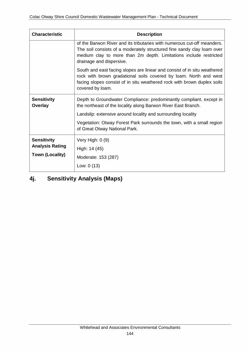
Colac Otway Shire Council Domestic Wastewater Management Plan - Technical Document
Whitehead and Associates Environmental Consultants 144
Characteristic Description
of the Barwon River and its tributaries with numerous cut-off meanders. The soil consists of a moderately structured fine sandy clay loam over medium clay to more than 2m depth. Limitations include restricted drainage and dispersive.
South and east facing slopes are linear and consist of in situ weathered rock with brown gradational soils covered by loam. North and west facing slopes consist of in situ weathered rock with brown duplex soils covered by loam.
Sensitivity Overlay
Depth to Groundwater Compliance: predominantly compliant, except in the northeast of the locality along Barwon River East Branch.
Landslip: extensive around locality and surrounding locality
Vegetation: Otway Forest Park surrounds the town, with a small region of Great Otway National Park.
Sensitivity Analysis Rating
Town (Locality)
Very High: 0 (9)
High: 14 (45)
Moderate: 153 (287)
Low: 0 (13)
4j. Sensitivity Analysis (Maps)
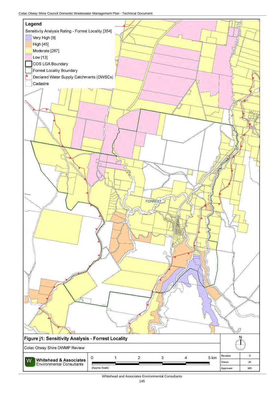
Colac Otway Shire Council Domestic Wastewater Management Plan - Technical Document
Whitehead and Associates Environmental Consultants 145
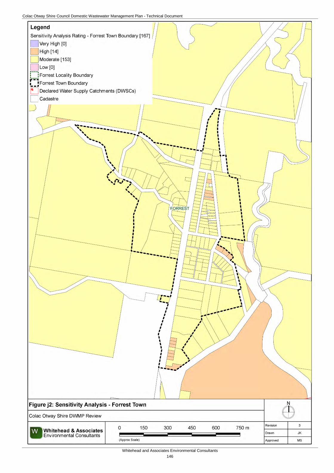
Colac Otway Shire Council Domestic Wastewater Management Plan - Technical Document
Whitehead and Associates Environmental Consultants 146
Colac Otway Shire Council Domestic Wastewater Management Plan - Technical Document
Whitehead and Associates Environmental Consultants 147
5j. System Selection Due to the dominance of heavy-textured soils in the Forrest area, conventional absorption trenches and beds are not likely to be feasible and are discouraged. Appendix A of the EPA Code of Practice (2013) prohibits LPED systems on Category 5 and 6 soils (medium to heavy clays). The System Sizing Tables (below) indicate which systems are likely to be the most appropriate for the locality.
6j. System Sizing Tables Sizing Tables for each system type were created using conservative monthly water balances, following methods described in the MAV Model LCA, 2014. The water balances used monthly 70th percentile rainfall and average evapotranspiration data for Gellibrand, as it was compared with that of Forrest and found to be very similar, with very little size differences in water balance results. The climate data for Gellibrand was sourced from SILO (Scientific Information for Land Owners) climate databases, which are managed by the Queensland Government. The SILO databases use accurate meteorological data collected throughout Australia over long time periods.
The Design Loading Rates (DLRs) and Design Irrigation Rates (DIRs) were taken from the current EPA Code of Practice. Where the Code of Practice has precluded use of a particular type of system on a certain soil type, it is shown as ‘Not Applicable’ for that soil type in the Sizing Tables. Where the evapotranspiration deficit requires unrealistically large land application areas for a particular system on a certain soil type, it is also shown as ‘Not Applicable’ for that soil type in the Sizing Tables. Detailed, site-specific LCAs and system designs would be required to further investigate the feasibility of systems deemed ‘Not Applicable’ in the sizing tables. Mitigation measures (such as importation of topsoil to appropriate depths in the land application area), may be required to sustainably achieve land application of effluent on constrained properties/parcels.
Sizing Tables for the Forrest locality are provided below.
7j. General Conclusion The properties/parcels within Forrest have been assigned all classes of Sensitivity Rating to sustainable DWM, with the majority of the properties/parcels assigned a Moderate Sensitivity Rating. Predominantly, Standard LCAs will be required, with the use of System Sizing Tables deemed appropriate. The Low Sensitivity Rating properties/parcels that fall within a DWSC are required to complete a Standard LCA as per the current EPA Code of Practice’s requirements. Particular attention needs to be directed towards ensuring that the degree of slope is taken into consideration when designing the LAA. The locality is also extensively considered to be prone to landslip; a geotechnical report by a suitably qualified person will need to be conducted to address this constraint.
Colac Otway Shire Council Domestic Wastewater Management Plan - Technical Document
Whitehead and Associates Environmental Consultants 148
Soil Category Gravels & Sands (1) Sandy Loams (2) Loams (3) Clay Loams (4) Light Clays (5) Medium to Heavy
Clays (6)DIR (mm) 5 5 4 3.5 3 2
Development Type Daily (L/day)5 + bedroom residence 1,080 586 804 1,269 1,8814 bedroom residence 900 489 670 1,068 1,568
1-3 bedroom residence 720 391 536 854 1,254
Soil Category Gravels & Sands (1) Sandy Loams (2) Loams (3)
Weak Loams & High/Mod Clay Loams (3 & 4)
Weak Clay Loams (4) Light Clays (5) Massive Clay
Loams (4)Medium to Heavy
Clays (6)
DLR (mm)Development Type Daily (L/day)
5 + bedroom residence 1,0804 bedroom residence 900
1-3 bedroom residence 720
Soil Category Gravels & Sands (1) Sandy Loams (2) Loams (3a) Weak/Massive
Loams (3b)High/Mod Clay
Loams (4a)
Weak Clay Loams (4b) & Strong
Light Clays (5a)
Massive Clay Loams (4c) and
Mod & Weak Light Clays (5b, 5c)
Medium to Heavy Clays (6) - Secondary
Effluent Only
DLR (mm) 20* 20* 15 10 12 8 5 5Development Type Daily (L/day)
5 + bedroom residence 1,080 87 144 114 1974 bedroom residence 900 72 120 95 164
1-3 bedroom residence 720 58 96 76 131
Soil Category Gravels & Sands (1) Sandy Loams (2) Loams (3) Clay Loams (4) Light Clays (5) Medium to Heavy
Clays (6)DIR (mm) 4 3.5
Development Type Daily (L/day)5 + bedroom residence 1,080 717 1,0734 bedroom residence 900 598 895
1-3 bedroom residence 720 478 716
Soil Category Gravels & Sands (1)
Sandy Loams (2) Loams (3) &
High/Mod Clay Loams (4a,b)
Weak Clay Loams (4)
Massive Clay Loams (4)
Strong Light Clays (5a)
Moderate Light Clays (5b)
Weak Light Clays (5c)
Medium to Heavy Clays (6)
DLR (mm) 25 30 20 10 12 8 8Development Type Daily (L/day)
5 + bedroom residence 1,080 48 40 62 145 1144 bedroom residence 900 40 33 52 121 95
1-3 bedroom residence 720 32 27 42 97 76
Evapotranspiration-Absorption Trenches and Beds - Primary Treated Effluent (Category 1 to 5) and Secondary Treated Effluent only (Category 6)
62
132
197164
Total min. basal or 'wetted area' required for zero wet weather storage (m2) not including spacing & setbacksN/A
(Alternative Land Application
System Required)
N/A (Alternative Land
Application System Required)
Total min. basal or 'wetted area'†
† required for zero wet weather storage (m2) not including spacing & setbacks
N/A (Alternative Land
Application System Required)
N/A (Alternative Land
Application System Required)
LPED Irrigation Systems - Primary or Secondary Treated Effluent
380317254
42
Wick Trenches and Beds - Secondary Treated Effluent Only
Conventional Absorption Trenches and Beds - Primary Treated Effluent
Note: * Gravels, Sands and sandy loams are unsuitable for conventional absorption trenches and beds if there is a high watertable, including seasonal and perched watertables. Value based on average of conservative rate and maximum rate for Category 2b and 3a soils in AS1547:2012
52
N/A (Alternative Land
Application System Required)
360288
Note: * irrigation system sizes are based on the assumption that the land application area is less than 10% slope. Reductions in DIR apply for slopes above 10% according to Table M2 of AS1547:2012
Not supported (Alternative Land Application System Required)
Forrest
Total min. irrigation area required for zero wet weather effluent storage (m2) not including spacing or setbacks
Total min. basal or 'wetted area' required for zero wet weather storage (m2) not including spacing & setbacks431
Drip and Spray Irrigation Systems* - Secondary Treated Effluent only
Colac Otway Shire Council Domestic Wastewater Management Plan - Technical Document
Whitehead and Associates Environmental Consultants 149
K. Gellibrand Locality Report 1k. Introduction Gellibrand is located approximately 21km south of Colac. It is located on elevated and dissected terraces or deeply dissected hills, abutting the Gellibrand River. Gellibrand is located on relatively flat land gently slopes in a northerly direction to the convergence of Charleys Creek and Lardner Creek. Notably, the entire locality is located within the Gellibrand River DWSC.
There are approximately 276 and 71 unsewered properties/parcels located within the Gellibrand locality and town, respectively, with 104 DWM system permits that have been inspected to date by COS. The current DWM permits and their associated treatment system and LAA method within the Gellibrand locality are summarised as follows:
• 9 AWTs (5 drip irrigation, 1 trenches, 1 irrigation and 1 unknown);
• 1 constructed reed beds wetland (1 trench);
• 35 sand filters (1 drip irrigation and 34 subsurface irrigation);
• 34 septic tanks (12 trenches, 1 subsurface irrigation and 21 unknown); and
• 25 unknown (10 trenches and 15 unknown).
2k. Background Documentation Refer to the following documents for additional detail regarding the locality:
• Gellibrand River Township Master Plan Report (October, 2005); and
• Colac Otway Domestic Wastewater Management Plan (2007);
• COS Planning Scheme; and
• Rural Living Strategy (2011).
3k. Site Assessment Results The following table summarises the results from the representative audits conducted by Consultant staff in September 2014.
Characteristic Description
Land use Comprises of a range of land uses, including dairy, forestry, rural living and tourism.
Occupancy rates 2.3 (Gellibrand State Suburb, ABS Census, 2011).
Typical soils Duplex profile. Very dark grey brown sandy clay loam surface soil overlying abruptly at 35cm a strongly mottled yellow brown, grey, strong brown silty clay, overlying a stratum of white and yellow coarse gravelly sand with rounded quartz pebbles between 140-170cm, overlying strongly mottled clay to at least 200cm. Drainage and permeability are variable depending on slope and position.
AS/NZS 1547:2012 5 (Light Clays)
Colac Otway Shire Council Domestic Wastewater Management Plan - Technical Document
Whitehead and Associates Environmental Consultants 150
Characteristic Description
soil categories
Existing Systems Separate Blackwater and Greywater
Of the seven systems inspected during field investigations, three systems (43%) comprised separate blackwater treatment in a septic tank, with direct greywater diversion to either an adjacent paddock or street drain. Where discharged to paddocks or neighbouring vacant properties/parcels, greywater was typically ponded near the diversion outlet pipe, and often in areas trampled by livestock (cattle and sheep).
The blackwater septic tanks were typically 40+ years old and less than half had been pumped out within the last ten years. Septic effluent discharged to one or more conventional absorption trenches, some of which could not be identified without the owner present. The majority of trenches were located on land of less than 8% slope and appeared to be parallel with contours (i.e. running across slope, not down it). There was evidence of blackwater effluent surcharging to the surface on one property (of three with separate blackwater and greywater systems). Soils were typically soft or boggy, mainly due to recent high rainfall.
Combined Blackwater and Greywater
Four of the seven systems (57%) inspected had combined wastewater treatment systems or were assumed to have combined systems, based on layout of pipework. It is likely that the proportion of combined systems in Gellibrand is likely to be less than this; however, this should be confirmed by ongoing inspections by Council.
Septic effluent discharged to one or more conventional absorption trenches. At least one of the four properties had undersized trenches for the number of bedrooms; and on one property the LAA could not be identified and there was inadequate suitable space for an appropriately sized LAA.
4k. Summary of Constraints to DWM Characteristic Description
Climate Zone Zone 3.
Surface waterways & catchments
The locality is located entirely within the Gellibrand River DWSC. There is an extensive drainage network surrounding the town; including Gellibrand River transversing southeast to northwest, Love Creek, Charleys Creek, Lardner Creek and Asplin Creek.
Groundwater Proximity to groundwater bores: significantly dense distribution throughout the town and along the river, similar to Kawarren.
Groundwater depth: 1.5 – 2m below surface.
Colac Otway Shire Council Domestic Wastewater Management Plan - Technical Document
Whitehead and Associates Environmental Consultants 151
Characteristic Description
Land subject to inundation
Extensive along Gellibrand River, Charleys Creek, Lardner Creek and Love Creek; envelopes the town.
Useable lot area
Town (Locality)
High: 19 (58)
Moderate: 33 (46)
Low: 19 (158)
Compliant: 0 (14)
Minimum lot size compliance with Planning Scheme Zoning
The locality is predominantly zoned Farming Zone and Public Conservation and Resource Zone. The town is zoned Township Zone, Public Park and Recreation Zone and Public Use Zone.
Compliancy is variable throughout the locality, with the majority of the properties/parcels within the town compliant.
Compliant: 67 (110)
Non-compliant: 4 (166)
Slope
Town (Locality)
High: 0 (92)
Moderate: 0 (25)
Low: 71 (159)
Geology Various underlying geology.
Majority of town is a river terrace with clay and sand which is moderately sorted and poorly consolidated. Northern tip is alluvial floodplain with silt, sand, and gravel deposits which are also moderately sorted and poorly consolidated.
South – Eumeralla Formation of the Otway Group.
Dilwyn Formation of Wangeripp Group is directly south of town.
Older Volcanic Group (volcanic plugs, sills, dykes, pillow and pyroclastic deposits) to the east and north of town.
Wiridjil Gravel Member of Pebble Point Formation to west of town towards Carlisle River.
South eastern edge is a shallow marine deposit with sand, clay and silt.
Soil suitability
Town (Locality)
High: 64 (125)
Moderate: 7 (151)
Low: 0 (0)
The majority of the town is classified as having a high soil suitability constraint.
The dominant soil landscape unit of the town consists of ‘67’ which
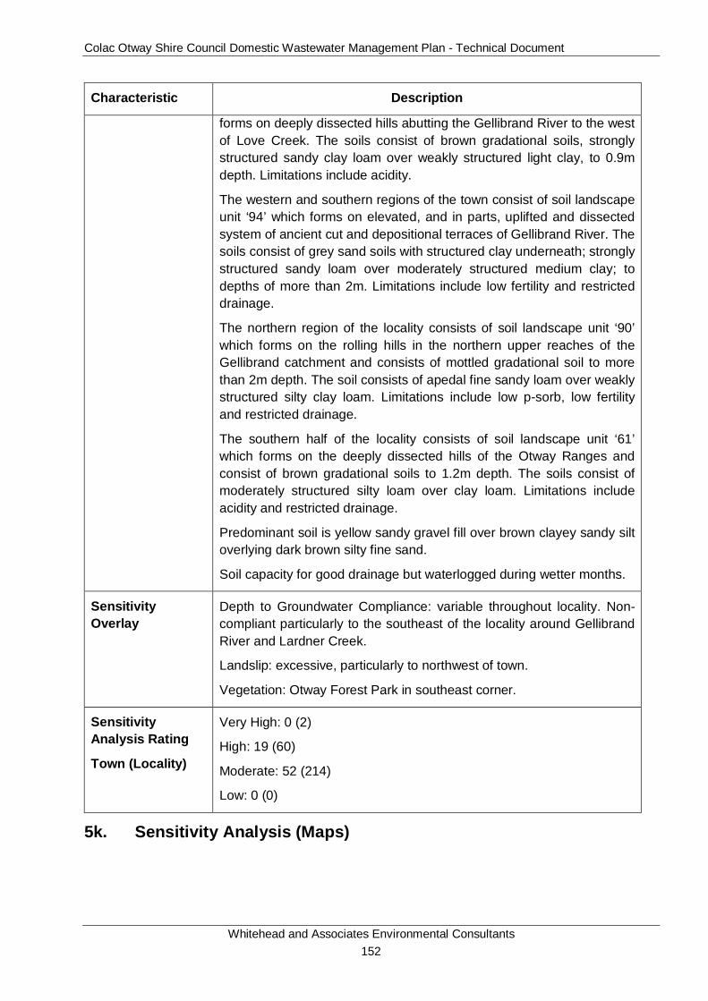
Colac Otway Shire Council Domestic Wastewater Management Plan - Technical Document
Whitehead and Associates Environmental Consultants 152
Characteristic Description
forms on deeply dissected hills abutting the Gellibrand River to the west of Love Creek. The soils consist of brown gradational soils, strongly structured sandy clay loam over weakly structured light clay, to 0.9m depth. Limitations include acidity.
The western and southern regions of the town consist of soil landscape unit ‘94’ which forms on elevated, and in parts, uplifted and dissected system of ancient cut and depositional terraces of Gellibrand River. The soils consist of grey sand soils with structured clay underneath; strongly structured sandy loam over moderately structured medium clay; to depths of more than 2m. Limitations include low fertility and restricted drainage.
The northern region of the locality consists of soil landscape unit ‘90’ which forms on the rolling hills in the northern upper reaches of the Gellibrand catchment and consists of mottled gradational soil to more than 2m depth. The soil consists of apedal fine sandy loam over weakly structured silty clay loam. Limitations include low p-sorb, low fertility and restricted drainage.
The southern half of the locality consists of soil landscape unit ‘61’ which forms on the deeply dissected hills of the Otway Ranges and consist of brown gradational soils to 1.2m depth. The soils consist of moderately structured silty loam over clay loam. Limitations include acidity and restricted drainage.
Predominant soil is yellow sandy gravel fill over brown clayey sandy silt overlying dark brown silty fine sand.
Soil capacity for good drainage but waterlogged during wetter months.
Sensitivity Overlay
Depth to Groundwater Compliance: variable throughout locality. Non-compliant particularly to the southeast of the locality around Gellibrand River and Lardner Creek.
Landslip: excessive, particularly to northwest of town.
Vegetation: Otway Forest Park in southeast corner.
Sensitivity Analysis Rating
Town (Locality)
Very High: 0 (2)
High: 19 (60)
Moderate: 52 (214)
Low: 0 (0)
5k. Sensitivity Analysis (Maps)
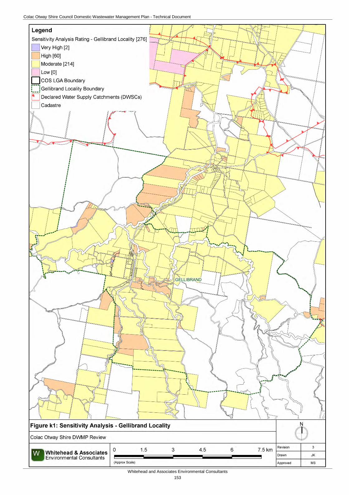
Colac Otway Shire Council Domestic Wastewater Management Plan - Technical Document
Whitehead and Associates Environmental Consultants 153
Colac Otway Shire Council Domestic Wastewater Management Plan - Technical Document
Whitehead and Associates Environmental Consultants 154
Colac Otway Shire Council Domestic Wastewater Management Plan - Technical Document
Whitehead and Associates Environmental Consultants 155
6k. System Selection Due to the dominance of heavy-textured soils in the Gellibrand locality, conventional absorption trenches and beds are not likely to be feasible and are discouraged. Appendix A of the EPA Code of Practice (2013) prohibits LPED systems on Category 5 and 6 soils (medium to heavy clays).
EPA Code of Practice (2013) (Section 2.2.2) identifies secondary treatment standard (or better) followed by subsurface pressure-compensating irrigation as current best-practice in Victoria for substantially reducing the risk associated with unsewered development. Further, the Code describes a “Wick trench/bed” land application option that may be incorporated with secondary treatment for consideration on sites constrained by climate or lot ‘useable area’, particularly within the DWSCs. Any variation from this best-practice approach must be provided with detailed supporting information to demonstrate suitability. The System Sizing Tables (below) indicate which systems are likely to be the most appropriate for the locality.
7k. System Sizing Tables Sizing Tables for each system type were created using conservative monthly water balances, following methods described in the MAV Model LCA, 2014. Monthly 70th percentile rainfall and average evapotranspiration data for Gellibrand was sourced from SILO (Scientific Information for Land Owners) climate databases, which are managed by the Queensland Government. The SILO databases use accurate meteorological data collected throughout Australia over long time periods.
The Design Loading Rates (DLRs) and Design Irrigation Rates (DIRs) were taken from the current EPA Code of Practice. Where the Code of Practice has precluded use of a particular type of system on a certain soil type, it is shown as ‘Not Applicable’ for that soil type in the Sizing Tables. Where the evapotranspiration deficit requires unrealistically large land application areas for a particular system on a certain soil type, it is also shown as ‘Not Applicable’ for that soil type in the Sizing Tables. Detailed, site-specific LCAs and system designs would be required to further investigate the feasibility of systems deemed ‘Not Applicable’ in the sizing tables. Mitigation measures (such as importation of topsoil to appropriate depths in the land application area), may be required to sustainably achieve land application of effluent on constrained properties/parcels.
Sizing Tables for the Gellibrand locality are provided below.
8k. General Conclusion The Rural Living Strategy (2011) identified Gellibrand as having ‘deferred’ growth potential, dependent on water catchment constraints and bushfire hazard being satisfactorily addressed. The Sensitivity Analysis concludes that development is feasible given its predominantly Moderate Sensitivity to DWM, particular within the town. Particular attention needs to be directed towards ensuring that appropriate setbacks to surface waterways, groundwater bores and flood prone areas are maintained, that the DWM systems are sized based on the limiting soil horizon and that the depth to groundwater during site-specific LCAs is ascertained. It is imperative that there is sufficient useable area to sustainably manage wastewater on-site. Some areas within the locality are considered to be extensively prone to landslip; a geotechnical report by a suitably qualified person will need to be conducted to address this constraint. Predominantly, Standard and Detailed LCAs will be required, with the use of System Sizing Tables deemed appropriate for the properties/parcels assigned a Moderate Sensitivity Rating.

Colac Otway Shire Council Domestic Wastewater Management Plan - Technical Document
Whitehead and Associates Environmental Consultants 156
The Low Sensitivity Rating properties/parcels within a DWSC are required to complete a Standard LCA as per the current EPA Code of Practice’s requirements.

Colac Otway Shire Council Domestic Wastewater Management Plan - Technical Document
Whitehead and Associates Environmental Consultants 157
Soil Category Gravels & Sands (1) Sandy Loams (2) Loams (3) Clay Loams (4) Light Clays (5) Medium to Heavy
Clays (6)DIR (mm) 5 5 4 3.5 3 2
Development Type Daily (L/day)5 + bedroom residence 1,080 584 800 1,269 2,3294 bedroom residence 900 487 667 1,058 1,941
1-3 bedroom residence 720 389 533 846 1,553
† not including spacing or setbacks
Soil Category Gravels & Sands (1) Sandy Loams (2) Loams (3)
Weak Loams & High/Mod Clay Loams (3 & 4)
Weak Clay Loams (4) Light Clays (5) Massive Clay
Loams (4)Medium to Heavy
Clays (6)
DLR (mm)Development Type Daily (L/day)
5 + bedroom residence 1,0804 bedroom residence 900
1-3 bedroom residence 720
Soil Category Gravels & Sands (1) Sandy Loams (2) Loams (3a) Weak/Massive
Loams (3b)High/Mod Clay
Loams (4a)
Weak Clay Loams (4b) & Strong
Light Clays (5a)
Massive Clay Loams (4c) and
Mod & Weak Light Clays (5b, 5c)
Medium to Heavy Clays (6) - Secondary
Effluent Only
DLR (mm) 20* 20* 15 10 12 8 5 5Development Type Daily (L/day)
5 + bedroom residence 1,080 87 145 114 1974 bedroom residence 900 73 121 95 164
1-3 bedroom residence 720 58 97 76 132
Soil Category Gravels & Sands (1) Sandy Loams (2) Loams (3) Clay Loams (4) Light Clays (5) Medium to Heavy
Clays (6)DIR (mm) 4 3.5
Development Type Daily (L/day)5 + bedroom residence 1,080 723 1,0864 bedroom residence 900 603 905
1-3 bedroom residence 720 482 724
Soil Category Gravels & Sands (1)
Sandy Loams (2) Loams (3) &
High/Mod Clay Loams (4a,b)
Weak Clay Loams (4)
Massive Clay Loams (4)
Strong Light Clays (5a)
Moderate Light Clays (5b)
Weak Light Clays (5c)
Medium to Heavy Clays (6)
DLR (mm) 25 30 20 10 12 8 8Development Type Daily (L/day)
5 + bedroom residence 1,080 49 40 62 145 1144 bedroom residence 900 41 33 52 121 95
1-3 bedroom residence 720 33 27 42 97 76
Evapotranspiration-Absorption Trenches and Beds - Primary Treated Effluent (Category 1 to 5) and Secondary Treated Effluent only (Category 6)
62
132
197164
Total min. basal or 'wetted area' required for zero wet weather storage (m2) not including spacing & setbacksN/A
(Alternative Land Application
System Required)
N/A (Alternative Land
Application System Required)
Total min. basal or 'wetted area'†
† required for zero wet weather storage (m2) not including spacing & setbacks
N/A (Alternative Land
Application System Required)
N/A (Alternative Land
Application System Required)
LPED Irrigation Systems - Primary or Secondary Treated Effluent
379316253
42
Wick Trenches and Beds - Secondary Treated Effluent Only
Conventional Absorption Trenches and Beds - Primary Treated Effluent
Note: * Gravels, Sands and sandy loams are unsuitable for conventional absorption trenches and beds if there is a high watertable, including seasonal and perched watertables. Value based on average of conservative rate and maximum rate for Category 2b and 3a soils in AS1547:2012
52
N/A (Alternative Land
Application System Required)
361289
Note: * irrigation system sizes are based on the assumption that the land application area is less than 10% slope. Reductions in DIR apply for slopes above 10% according to Table M2 of AS1547:2012
Gellibrand & Kawarren
Not supported (Alternative Land Application System Required)
Total min. basal or 'wetted area' required for zero wet weather storage (m2) not including spacing & setbacks433
Drip and Spray Irrigation Systems* - Secondary Treated Effluent only
Total min. irrigation area required for zero wet weather effluent storage (m2)†
Colac Otway Shire Council Domestic Wastewater Management Plan - Technical Document
Whitehead and Associates Environmental Consultants 158
L. Kawarren Locality Report 1l. Introduction Kawarren is located approximately 16km south of Colac. It is located on rolling hills or dissected hills abutting rivers and streams or large flood plains with undulating agricultural land. Notably, approximately 90% of the locality is located within a DWSC; predominantly Gellibrand River DWSC and a small portion in the northeast corner located within Barwon Downs Wellfield Intake DWSC.
There are approximately 215 and 72 unsewered properties/parcels located within the Kawarren locality and settlement, respectively, with 62 DWM system permits that have been inspected to date by COS. The current DWM permits and their associated treatment system and LAA method within the Kawarren locality are summarised as follows:
• 6 AWTS (1 drip irrigation, 1 trench, 1 irrigation and 2 unknown);
• 1 composting toilet (1 trench);
• 3 sand filter (1 irrigation and 2 subsurface irrigation);
• 36 septic tank (12 trenches and 24 unknown); and
• 16 unknown (10 trenches and 6 unknown).
2l. Background Documentation Refer to the following documents for additional detail regarding the locality:
• COS Planning Scheme; and
• Rural Living Strategy (2011).
3l. Site Assessment Results The following table summarises the results from the representative audits conducted by Consultant staff in September 2014.
Characteristic Description
Land use Comprises of a range of land uses, including dairy, forestry, rural living and tourism.
Occupancy rates 2.3 persons (Part of the Gellibrand State Suburb ABS Census, 2011)5.
Typical soils
Grey brown fine sandy loam to fine sandy clay loam becoming mottled at 15cm, abrupt change at 30cm to mottled light yellow grown and grey brown silty clay loam, grading to increasing mottling with depth to bright dark yellow brown, strong brown silty clay loam with some black small concretions below 80cm depth. Drainage and permeability are variable depending on slope and position.
5 No separate data for individual small townships and localities.
Colac Otway Shire Council Domestic Wastewater Management Plan - Technical Document
Whitehead and Associates Environmental Consultants 159
Characteristic Description
AS/NZS 1547:2012 soil categories 4 (Clay Loams) to 5 (Light Clays)
Existing Systems
Separate Blackwater and Greywater
Of the 8 systems inspected during field investigations, 75% of systems comprised separate blackwater treatment in a septic tank, with direct greywater diversion to an adjacent paddock (not to street drains, due to blocks generally sloping away from the street frontage). Greywater was typically ponded near the diversion outlet pipe, and often in areas trampled by livestock (cattle and sheep).
The blackwater septic tanks were typically 40+ years old and approximately half had been pumped out within the last ten years. Septic effluent discharged to one or more conventional absorption trenches, some of which could not be identified without the owner present. The majority of trenches were located on land of less than 8% slope and appeared to be parallel with contours (i.e. running across slope, not down it). There was no evidence of blackwater effluent surcharging to the surface; however soils were typically soft or boggy, mainly due to recent high rainfall.
Combined Blackwater and Greywater
25% of systems inspected had combined wastewater treatment systems or were assumed to have combined systems, based on layout of pipework. It is likely that the proportion of combined systems in Kawarren is less than this; however, this should be confirmed by ongoing inspections by Council.
Septic effluent discharged to one or more conventional absorption trenches, which were all undersized for the number of bedrooms, and/or located in inadequately sized available land application areas (LAAs).
4l. Summary of Constraints to DWM Characteristic Description
Climate Zone Zones 2 and 3.
Surface waterways & catchments
The locality is located within the Gellibrand River and Barwon Downs Wellfield Intake DWSCs. The waterways include: Love Creek to the north of the settlement, Yahoo Creek, Ten Mile Creek, and Porcupine Creek which contains an extensive waterbody.
Groundwater Proximity to groundwater bores: significantly dense distribution throughout the settlement and along the river, similar to Gellibrand.

Colac Otway Shire Council Domestic Wastewater Management Plan - Technical Document
Whitehead and Associates Environmental Consultants 160
Characteristic Description
Land subject to inundation Nil.
Useable lot area
Settlement (Locality)
High: 37 (72)
Moderate: 6 (16)
Low: 29 (121)
Compliant: 0 (6)
Minimum lot size compliance with Planning Scheme Zoning
The locality is predominantly zoned Farming Zone and Public Conservation and Resource Zone. The settlement is zoned Rural Living Zone.
The majority of properties/parcels are non-compliant, particularly within the settlement.
Compliant: 2 (29)
Non-compliant: 70 (186)
Slope
Settlement (Locality)
High: 6 (58)
Moderate: 29 (74)
Low: 37 (83)
Geology Gellibrand Marl of Heytesbury Group (continental shelf deposits) is dominant with Older Volcanic Group to the west and north of settlement. The Clifton Formation of Heytesbury Group straddles the Older Volcanic Group and alluvial flood plain deposits. Demons Bluff Formation of the Nirranda Group is to the north of locality.
Soil suitability
Settlement (Locality)
High: 0 (13)
Moderate: 72 (202)
Low: 0 (0)
Variable soil landscapes throughout locality (5 in total).
The settlement and the majority of the locality consists of soil landscape unit ‘90’ which forms on the rolling hills in the northern upper reaches of the Gellibrand catchment and consists of mottled gradational soil to more than 2m depth. The soil consists of apedal fine sandy loam over weakly structured silty clay loam. Limitations include low p-sorb, low fertility and restricted drainage.
The settlement and to the east of the locality consists of soil landscape unit ‘76’ which forms on undulating plains. The soil consists of grey sand soils to more than 2m depth with weak loamy sand overlying apedal sand. Limitations include low fertility.
Colac Otway Shire Council Domestic Wastewater Management Plan - Technical Document
Whitehead and Associates Environmental Consultants 161
Characteristic Description
Sensitivity Overlay Depth to Groundwater Compliance: predominantly compliant, except for along Love Creek which transverses northeast to southwest around the settlement.
Landslip: minimal, with a few large regions to the east of the settlement.
Vegetation: eastern half of locality consists of Otway Forest Park and Great Otway National Park.
Sensitivity Analysis Rating
Settlement (Locality)
Very High: 0 (0)
High: 12 (35)
Moderate: 60 (180)
Low: 0 (0)
5l. Sensitivity Analysis (Maps)
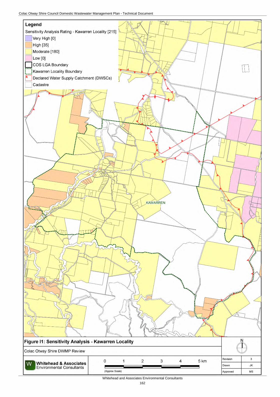
Colac Otway Shire Council Domestic Wastewater Management Plan - Technical Document
Whitehead and Associates Environmental Consultants 162
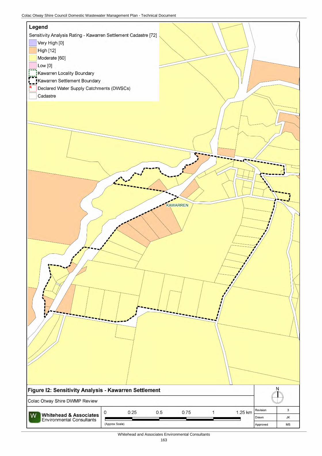
Colac Otway Shire Council Domestic Wastewater Management Plan - Technical Document
Whitehead and Associates Environmental Consultants 163
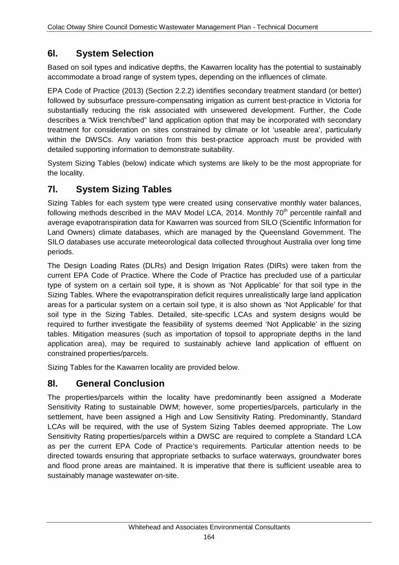
Colac Otway Shire Council Domestic Wastewater Management Plan - Technical Document
Whitehead and Associates Environmental Consultants 164
6l. System Selection Based on soil types and indicative depths, the Kawarren locality has the potential to sustainably accommodate a broad range of system types, depending on the influences of climate.
EPA Code of Practice (2013) (Section 2.2.2) identifies secondary treatment standard (or better) followed by subsurface pressure-compensating irrigation as current best-practice in Victoria for substantially reducing the risk associated with unsewered development. Further, the Code describes a “Wick trench/bed” land application option that may be incorporated with secondary treatment for consideration on sites constrained by climate or lot ‘useable area’, particularly within the DWSCs. Any variation from this best-practice approach must be provided with detailed supporting information to demonstrate suitability.
System Sizing Tables (below) indicate which systems are likely to be the most appropriate for the locality.
7l. System Sizing Tables Sizing Tables for each system type were created using conservative monthly water balances, following methods described in the MAV Model LCA, 2014. Monthly 70th percentile rainfall and average evapotranspiration data for Kawarren was sourced from SILO (Scientific Information for Land Owners) climate databases, which are managed by the Queensland Government. The SILO databases use accurate meteorological data collected throughout Australia over long time periods.
The Design Loading Rates (DLRs) and Design Irrigation Rates (DIRs) were taken from the current EPA Code of Practice. Where the Code of Practice has precluded use of a particular type of system on a certain soil type, it is shown as ‘Not Applicable’ for that soil type in the Sizing Tables. Where the evapotranspiration deficit requires unrealistically large land application areas for a particular system on a certain soil type, it is also shown as ‘Not Applicable’ for that soil type in the Sizing Tables. Detailed, site-specific LCAs and system designs would be required to further investigate the feasibility of systems deemed ‘Not Applicable’ in the sizing tables. Mitigation measures (such as importation of topsoil to appropriate depths in the land application area), may be required to sustainably achieve land application of effluent on constrained properties/parcels.
Sizing Tables for the Kawarren locality are provided below.
8l. General Conclusion The properties/parcels within the locality have predominantly been assigned a Moderate Sensitivity Rating to sustainable DWM; however, some properties/parcels, particularly in the settlement, have been assigned a High and Low Sensitivity Rating. Predominantly, Standard LCAs will be required, with the use of System Sizing Tables deemed appropriate. The Low Sensitivity Rating properties/parcels within a DWSC are required to complete a Standard LCA as per the current EPA Code of Practice’s requirements. Particular attention needs to be directed towards ensuring that appropriate setbacks to surface waterways, groundwater bores and flood prone areas are maintained. It is imperative that there is sufficient useable area to sustainably manage wastewater on-site.
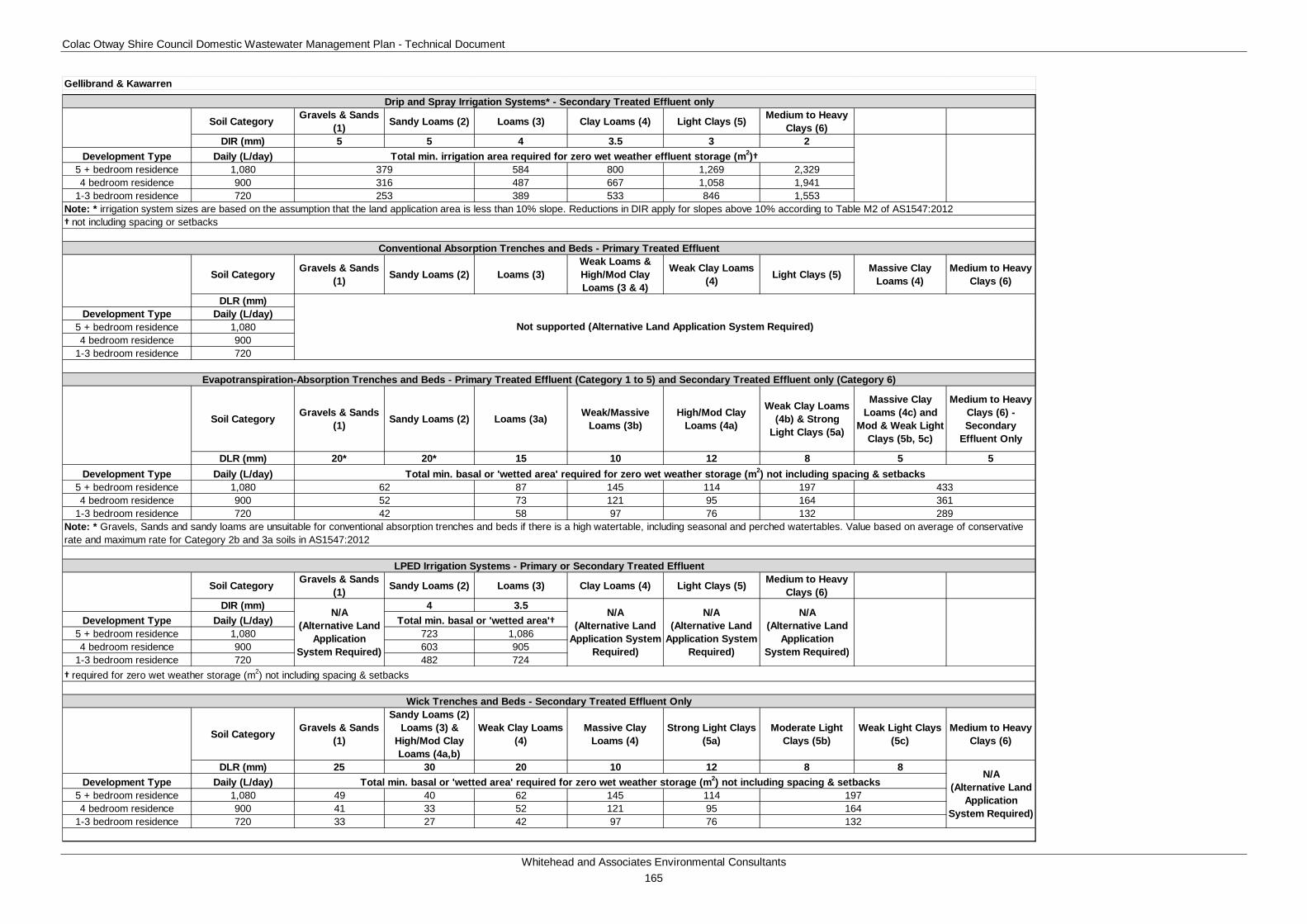
Colac Otway Shire Council Domestic Wastewater Management Plan - Technical Document
Whitehead and Associates Environmental Consultants 165
Soil Category Gravels & Sands (1) Sandy Loams (2) Loams (3) Clay Loams (4) Light Clays (5) Medium to Heavy
Clays (6)DIR (mm) 5 5 4 3.5 3 2
Development Type Daily (L/day)5 + bedroom residence 1,080 584 800 1,269 2,3294 bedroom residence 900 487 667 1,058 1,941
1-3 bedroom residence 720 389 533 846 1,553
† not including spacing or setbacks
Soil Category Gravels & Sands (1) Sandy Loams (2) Loams (3)
Weak Loams & High/Mod Clay Loams (3 & 4)
Weak Clay Loams (4) Light Clays (5) Massive Clay
Loams (4)Medium to Heavy
Clays (6)
DLR (mm)Development Type Daily (L/day)
5 + bedroom residence 1,0804 bedroom residence 900
1-3 bedroom residence 720
Soil Category Gravels & Sands (1) Sandy Loams (2) Loams (3a) Weak/Massive
Loams (3b)High/Mod Clay
Loams (4a)
Weak Clay Loams (4b) & Strong
Light Clays (5a)
Massive Clay Loams (4c) and
Mod & Weak Light Clays (5b, 5c)
Medium to Heavy Clays (6) - Secondary
Effluent Only
DLR (mm) 20* 20* 15 10 12 8 5 5Development Type Daily (L/day)
5 + bedroom residence 1,080 87 145 114 1974 bedroom residence 900 73 121 95 164
1-3 bedroom residence 720 58 97 76 132
Soil Category Gravels & Sands (1) Sandy Loams (2) Loams (3) Clay Loams (4) Light Clays (5) Medium to Heavy
Clays (6)DIR (mm) 4 3.5
Development Type Daily (L/day)5 + bedroom residence 1,080 723 1,0864 bedroom residence 900 603 905
1-3 bedroom residence 720 482 724
Soil Category Gravels & Sands (1)
Sandy Loams (2) Loams (3) &
High/Mod Clay Loams (4a,b)
Weak Clay Loams (4)
Massive Clay Loams (4)
Strong Light Clays (5a)
Moderate Light Clays (5b)
Weak Light Clays (5c)
Medium to Heavy Clays (6)
DLR (mm) 25 30 20 10 12 8 8Development Type Daily (L/day)
5 + bedroom residence 1,080 49 40 62 145 1144 bedroom residence 900 41 33 52 121 95
1-3 bedroom residence 720 33 27 42 97 76
Evapotranspiration-Absorption Trenches and Beds - Primary Treated Effluent (Category 1 to 5) and Secondary Treated Effluent only (Category 6)
62
132
197164
Total min. basal or 'wetted area' required for zero wet weather storage (m2) not including spacing & setbacksN/A
(Alternative Land Application
System Required)
N/A (Alternative Land
Application System Required)
Total min. basal or 'wetted area'†
† required for zero wet weather storage (m2) not including spacing & setbacks
N/A (Alternative Land
Application System Required)
N/A (Alternative Land
Application System Required)
LPED Irrigation Systems - Primary or Secondary Treated Effluent
379316253
42
Wick Trenches and Beds - Secondary Treated Effluent Only
Conventional Absorption Trenches and Beds - Primary Treated Effluent
Note: * Gravels, Sands and sandy loams are unsuitable for conventional absorption trenches and beds if there is a high watertable, including seasonal and perched watertables. Value based on average of conservative rate and maximum rate for Category 2b and 3a soils in AS1547:2012
52
N/A (Alternative Land
Application System Required)
361289
Note: * irrigation system sizes are based on the assumption that the land application area is less than 10% slope. Reductions in DIR apply for slopes above 10% according to Table M2 of AS1547:2012
Gellibrand & Kawarren
Not supported (Alternative Land Application System Required)
Total min. basal or 'wetted area' required for zero wet weather storage (m2) not including spacing & setbacks433
Drip and Spray Irrigation Systems* - Secondary Treated Effluent only
Total min. irrigation area required for zero wet weather effluent storage (m2)†
Colac Otway Shire Council Domestic Wastewater Management Plan - Technical Document
Whitehead and Associates Environmental Consultants 166
M. Kennett River Locality Report 1m. Introduction Kennett River is a coastal locality along the south-eastern coastline of COS, approximately 20km northeast of Apollo Bay, in the heavily vegetated foothills of the south-eastern section of the Otway Ranges. The locality is not located within a DWSC.
There are 186 and 180 unsewered properties/parcels within the Kennett River locality and town, respectively, and 111 DWM system permits that have been inspected to date by COS. The current DWM permits and their associated treatment system and LAA method within the Kennett River locality is summarised as follows:
• 31 AWTS (13 drip irrigation, 3 irrigation, 4 subsurface irrigation, 2 trenches and 9 unknown);
• 52 sand filters (50 subsurface irrigation, 1 trench and 1 unknown)
• 9 septic tanks (2 trenches and 7 unknown)
• 19 unknown (5 trenches, 1 subsurface irrigation and 13 unknown).
No field investigations were conducted in Kennett River as part of the 2014 field assessments.
2m. Background Documentation Refer to the following documents for additional detail regarding the locality.
• Colac Otway Shire Coastal Community Revitalisation Project (April 2003);
• Colac Otway Shire, Three Towns Stormwater Management Strategy, Concept Study (October 2004);
• Concept Design for Wye River Separation Creek and Kennett River, (June 2006);
• Kennett River, Wye River and Separation Creek Structure Plans (February 2008);
• COS Planning Scheme; and
• Rural Living Strategy (2011).
3m. Summary of Constraints to DWM Characteristic Description
Climate Zone Zone 2.
Surface waterways & catchments
The locality is not located within a DWSC. Kennett River and its tributaries form the major waterway within this region and confluences with the Southern Ocean. Kennett River east and west branches are located in the top of the catchment before merging. Additional waterways within the Kennett River locality include, Grey River and Carisbrook Creek which flows along the western locality boundary.
Groundwater Proximity to groundwater bores: none.
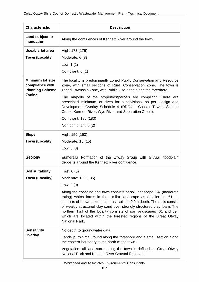
Colac Otway Shire Council Domestic Wastewater Management Plan - Technical Document
Whitehead and Associates Environmental Consultants 167
Characteristic Description
Land subject to inundation Along the confluences of Kennett River around the town.
Useable lot area
Town (Locality)
High: 173 (175)
Moderate: 6 (8)
Low: 1 (2)
Compliant: 0 (1)
Minimum lot size compliance with Planning Scheme Zoning
The locality is predominantly zoned Public Conservation and Resource Zone, with small sections of Rural Conservation Zone. The town is zoned Township Zone, with Public Use Zone along the foreshore.
The majority of the properties/parcels are compliant. There are prescribed minimum lot sizes for subdivisions, as per Design and Development Overlay Schedule 4 (DDO4 – Coastal Towns: Skenes Creek, Kennett River, Wye River and Separation Creek).
Compliant: 180 (183)
Non-compliant: 0 (3)
Slope
Town (Locality)
High: 159 (163)
Moderate: 15 (15)
Low: 6 (8)
Geology Eumeralla Formation of the Otway Group with alluvial floodplain deposits around the Kennett River confluence.
Soil suitability
Town (Locality)
High: 0 (0)
Moderate: 180 (186)
Low: 0 (0)
Along the coastline and town consists of soil landscape ‘64’ (moderate rating) which forms in the similar landscape as detailed in ‘61’. It consists of brown texture contrast soils to 0.9m depth. The soils consist of weakly structured clay sand over strongly structured clay loam. The northern half of the locality consists of soil landscapes ’61 and 59’, which are located within the forested regions of the Great Otway National Park.
Sensitivity Overlay
No depth to groundwater data.
Landslip: minimal, found along the foreshore and a small section along the eastern boundary to the north of the town.
Vegetation: all land surrounding the town is defined as Great Otway National Park and Kennett River Coastal Reserve.

Colac Otway Shire Council Domestic Wastewater Management Plan - Technical Document
Whitehead and Associates Environmental Consultants 168
Characteristic Description
Sensitivity Analysis Rating
Town (Locality)
Very High: 0 (0)
High: 173 (175)
Moderate: 7 (11)
Low: 0 (0)
4m. Sensitivity Analysis (Maps)
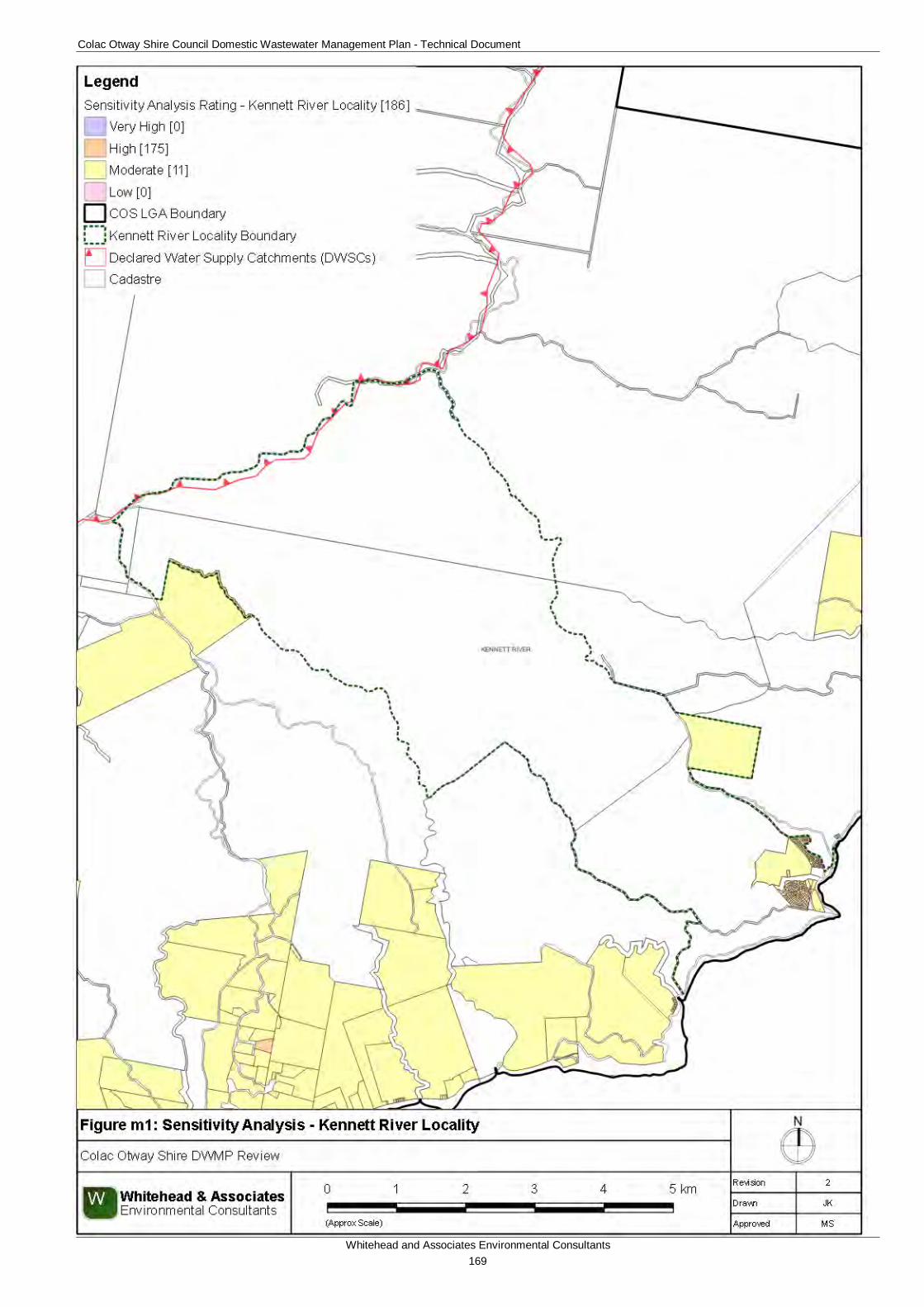
Colac Otway Shire Council Domestic Wastewater Management Plan - Technical Document
Whitehead and Associates Environmental Consultants 169
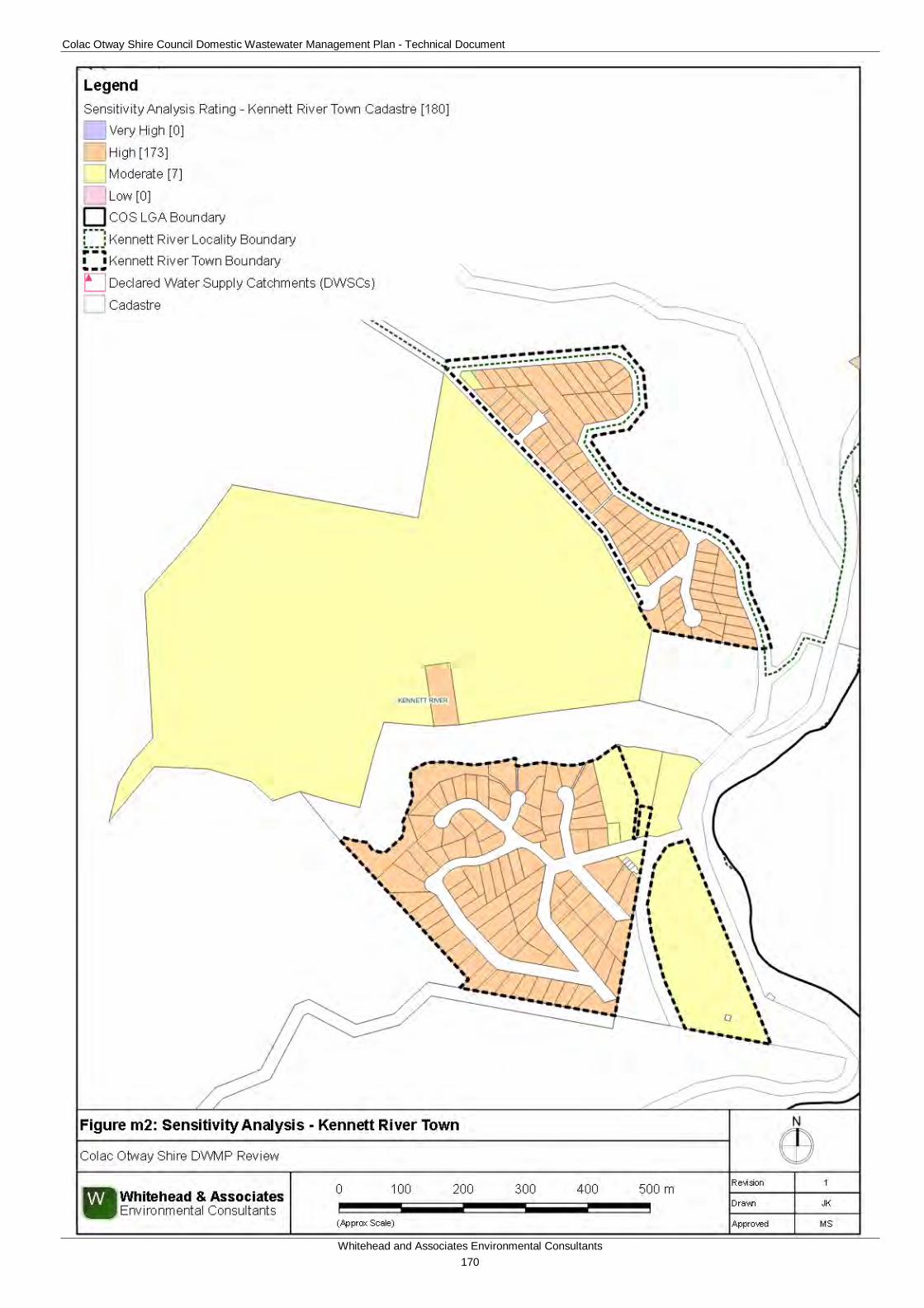
Colac Otway Shire Council Domestic Wastewater Management Plan - Technical Document
Whitehead and Associates Environmental Consultants 170
Colac Otway Shire Council Domestic Wastewater Management Plan - Technical Document
Whitehead and Associates Environmental Consultants 171
5m. System Selection Soil types vary significantly in the Kennett River area depending on position in the landscape (i.e. sand deltas or hill slopes). Appendix A of the EPA Code of Practice (2013) prohibits conventional and modified trenches and beds as well as LPED systems on Category 1 soils (sands), which preclude these systems on the delta areas. Landslip risks and land gradients are major constraints for DWM on properties/parcels located on the hillslopes in the locality. As such, site-specific LCA investigations and system designs are recommended; however the sizing tables (below) provide some guidance on which systems may be appropriate. Note that the DIR for subsurface irrigation systems has not been reduced to account for slopes above 10% (as is recommended in AS/NZS 1547:2012). Surface irrigation is not recommended on slopes greater than 10%.
6m. System Sizing Tables Sizing Tables for each system type were created using conservative monthly water balances, following methods described in the MAV Model LCA, 2014. Monthly 70th percentile rainfall and average evapotranspiration data for the Kennett River and Sugarloaf area was sourced from SILO (Scientific Information for Land Owners) climate databases, which are managed by the Queensland Government. The SILO databases use accurate meteorological data collected throughout Australia over long time periods.
The Design Loading Rates (DLRs) and Design Irrigation Rates (DIRs) were taken from the current EPA Code of Practice. Where the Code of Practice has precluded use of a particular type of system on a certain soil type, it is shown as ‘Not Applicable’ for that soil type in the Sizing Tables. Where the evapotranspiration deficit requires unrealistically large land application areas for a particular system on a certain soil type, it is also shown as ‘Not Applicable’ for that soil type in the Sizing Tables. Detailed, site-specific LCAs and system designs would be required to further investigate the feasibility of systems deemed ‘Not Applicable’ in the sizing tables. Mitigation measures (such as importation of topsoil to appropriate depths in the land application area), may be required to sustainably achieve land application of effluent on constrained properties/parcels.
Sizing Tables for the Kennett River locality are provided below.
7m. General Conclusion The properties/parcels within the locality have been assigned a Moderate or High Sensitivity Rating to sustainable DWM, with the majority of the town assigned as High. Both Standard and Detailed LCAs will be required, with the use of System Sizing Tables deemed appropriate for the Standard LCAs. Particular attention needs to be directed towards ensuring that the DWM systems are sized based on the limiting soil horizon, which may be relatively shallow, and that the systems selected are appropriate for steeper slopes with correct construction. The majority of properties/parcels within the region also have less than 1,500m2 of useable area for DWM, which also does not exclude heavily vegetated areas. This will limit design options and it is imperative that the LCA DWM system design ensure that DWM is contained on-site.
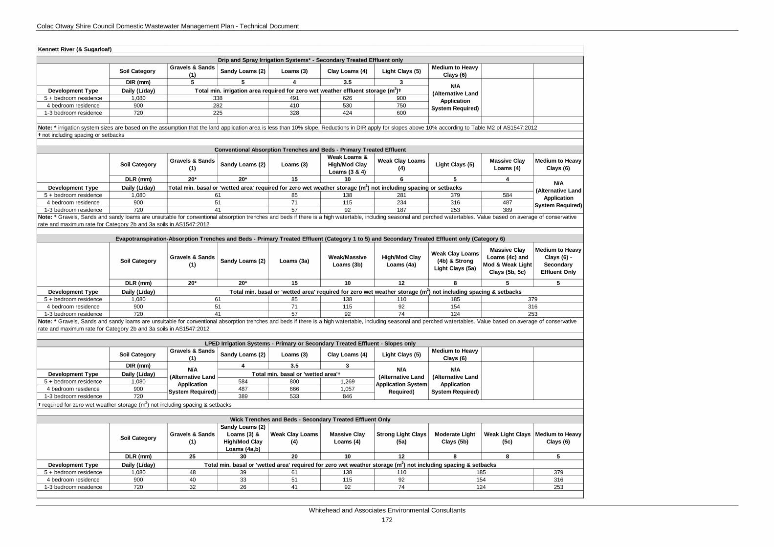
Colac Otway Shire Council Domestic Wastewater Management Plan - Technical Document
Whitehead and Associates Environmental Consultants 172
Soil Category Gravels & Sands (1) Sandy Loams (2) Loams (3) Clay Loams (4) Light Clays (5) Medium to Heavy
Clays (6)DIR (mm) 5 5 4 3.5 3
Development Type Daily (L/day)5 + bedroom residence 1,080 491 626 9004 bedroom residence 900 410 530 750
1-3 bedroom residence 720 328 424 600
† not including spacing or setbacks
Soil Category Gravels & Sands (1) Sandy Loams (2) Loams (3)
Weak Loams & High/Mod Clay Loams (3 & 4)
Weak Clay Loams (4) Light Clays (5) Massive Clay
Loams (4)Medium to Heavy
Clays (6)
DLR (mm) 20* 20* 15 10 6 5 4Development Type Daily (L/day) Total min. basal or 'wetted area' required for zero wet weather storage (m2) not including spacing or setbacks
5 + bedroom residence 1,080 85 138 281 379 5844 bedroom residence 900 71 115 234 316 487
1-3 bedroom residence 720 57 92 187 253 389
Soil Category Gravels & Sands (1) Sandy Loams (2) Loams (3a) Weak/Massive
Loams (3b)High/Mod Clay
Loams (4a)
Weak Clay Loams (4b) & Strong
Light Clays (5a)
Massive Clay Loams (4c) and
Mod & Weak Light Clays (5b, 5c)
Medium to Heavy Clays (6) - Secondary
Effluent Only
DLR (mm) 20* 20* 15 10 12 8 5 5Development Type Daily (L/day)
5 + bedroom residence 1,080 85 138 110 1854 bedroom residence 900 71 115 92 154
1-3 bedroom residence 720 57 92 74 124
Soil Category Gravels & Sands (1) Sandy Loams (2) Loams (3) Clay Loams (4) Light Clays (5) Medium to Heavy
Clays (6)DIR (mm) 4 3.5 3
Development Type Daily (L/day)5 + bedroom residence 1,080 584 800 1,2694 bedroom residence 900 487 666 1,057
1-3 bedroom residence 720 389 533 846
Soil Category Gravels & Sands (1)
Sandy Loams (2) Loams (3) &
High/Mod Clay Loams (4a,b)
Weak Clay Loams (4)
Massive Clay Loams (4)
Strong Light Clays (5a)
Moderate Light Clays (5b)
Weak Light Clays (5c)
Medium to Heavy Clays (6)
DLR (mm) 25 30 20 10 12 8 8 5Development Type Daily (L/day)
5 + bedroom residence 1,080 48 39 61 138 110 3794 bedroom residence 900 40 33 51 115 92 316
1-3 bedroom residence 720 32 26 41 92 74 253
253
N/A (Alternative Land
Application System Required)
Note: * irrigation system sizes are based on the assumption that the land application area is less than 10% slope. Reductions in DIR apply for slopes above 10% according to Table M2 of AS1547:2012
N/A (Alternative Land
Application System Required)
615141
Note: * Gravels, Sands and sandy loams are unsuitable for conventional absorption trenches and beds if there is a high watertable, including seasonal and perched watertables. Value based on average of conservative rate and maximum rate for Category 2b and 3a soils in AS1547:2012
Drip and Spray Irrigation Systems* - Secondary Treated Effluent only
LPED Irrigation Systems - Primary or Secondary Treated Effluent - Slopes only
338282225
41
Total min. irrigation area required for zero wet weather effluent storage (m2)†
Conventional Absorption Trenches and Beds - Primary Treated Effluent
Note: * Gravels, Sands and sandy loams are unsuitable for conventional absorption trenches and beds if there is a high watertable, including seasonal and perched watertables. Value based on average of conservative rate and maximum rate for Category 2b and 3a soils in AS1547:2012
51
N/A (Alternative Land
Application System Required)
† required for zero wet weather storage (m2) not including spacing & setbacks
Total min. basal or 'wetted area'†
61Total min. basal or 'wetted area' required for zero wet weather storage (m2) not including spacing & setbacks
379316
N/A (Alternative Land
Application System Required)
N/A (Alternative Land
Application System Required)
Evapotranspiration-Absorption Trenches and Beds - Primary Treated Effluent (Category 1 to 5) and Secondary Treated Effluent only (Category 6)
Kennett River (& Sugarloaf)
124
185154
Total min. basal or 'wetted area' required for zero wet weather storage (m2) not including spacing & setbacks
Wick Trenches and Beds - Secondary Treated Effluent Only
Colac Otway Shire Council Domestic Wastewater Management Plan - Technical Document
Whitehead and Associates Environmental Consultants 173
N. Lavers Hill Locality Report 1n. Introduction Lavers Hill is located approximately 41km southwest of Colac within the southern section of COS. The locality centres on a narrow ridgeline on the Great Ocean Road. The landform consists of undulating, dissected crests and rolling hills of the Otway Ranges. Notably, the locality on the northern side of the ridgeline is located within the Gellibrand River (South Otway) DWSC as indicated by the surface water informative map A1, Appendix A.
There are approximately 204 and 84 unsewered properties/parcels located within the Lavers Hill locality and town, with 42 DWM system permits that have been inspected to date by COS. The current DWM permits and their associated treatment system and LAA method within the Lavers Hill locality are summarised as follows:
• 12 AWTS (4 drip irrigation, 3 trenches, 1 subsurface irrigation and 4 unknown);
• 12 septic tanks (5 trenches, 1 subsurface irrigation and 6 unknown); and
• 18 unknown (11 trenches, 1 irrigation, 1 subsurface irrigation and 5 unknown).
2n. Background Documentation Refer to the following documents for additional detail regarding the locality:
• Amended Urban Design Framework Plan for Lavers Hill (June, 2006);
• COS Planning Scheme; and
• Rural Living Strategy (2011).
3n. Site Assessment Results The following table summarises the results from the representative audits conducted by Consultant staff in September 2014.
Characteristic Description
Land use Comprises a range of land uses, including dairy, forestry, rural living and tourism.
Occupancy rates 2.3 (Part of the Beech Forest State Suburb, ABS Census, 2011).
Typical soils
Gradational profile with very dark grey brown silty clay loam topsoil becoming mottled with dark grey brown and dark yellow brown between 40-60 cm, then more strongly mottled dark yellow brown, yellow brown and grey brown silty clay to 80+ cm. Drainage and permeability are variable depending on slope and position.
AS/NZS 1547:2012 soil categories 4 (Clay Loams) and 5 (Light Clays).
Existing Systems Separate Blackwater and Greywater
Of the six systems inspected during field investigations, two or three
Colac Otway Shire Council Domestic Wastewater Management Plan - Technical Document
Whitehead and Associates Environmental Consultants 174
Characteristic Description
systems (33-50%) comprised separate blackwater treatment in a septic tank, with direct greywater diversion to an adjacent paddock or within the property boundary.
The blackwater septic tanks were typically 30+ years old (or not found) and the time since last pump-out was generally unknown (partly due to owner not being home to ascertain). Septic effluent discharged to one or more conventional absorption trenches (or was assumed to if trenches could not be identified). The trench dimensions were generally unclear, and it is likely that most trenches were undersized for the number of bedrooms. One property had poorly-treated blackwater effluent being discharged to the ground surface from a broken pipe. LAA slopes ranged from 2-10%.
Combined Blackwater and Greywater
Three or four systems (50-67%) inspected have a combined wastewater treatment system, or were assumed to have based on layout of pipework and age of dwelling. This included one combined AWTS (less than 2 years old) for a commercial property, and a retrofitted AWTS using one of three existing septic tanks on another commercial property.
Septic tank effluent discharged to a series of conventional absorption trenches in LAAs generally of less than 4% slope. Most trenches could be identified and all were undersized for the number of bedrooms and/or the type of property.
The standalone AWTS discharged effluent to subsurface irrigation which appeared to be undersized based on the likely patronage over the peak tourism season, and had boggy sections.
The retrofitted AWTS discharged effluent to an undersized trench LAA.
4n. Summary of Constraints to DWM Characteristic Description
Climate Zone The town is included within Zone 4 and part of the surrounding locality is located within Zone 3.
Surface waterways & catchments
Lavers Hill is similar to Beech Forest, whereby the northern half of the locality is within a DWSC, Gellibrand River. The DWSC boundary runs along the ridgeline which forms the main road which divides the town. The waterways include: Chapple Creek South and North Branch, Skinner Creek, Sandy Creek, Melba Gully and Ford River West Branch.
Groundwater Proximity to groundwater bores: Nil.
Land subject to Nil
Colac Otway Shire Council Domestic Wastewater Management Plan - Technical Document
Whitehead and Associates Environmental Consultants 175
Characteristic Description
inundation
Useable lot area
Town (Locality)
High: 52 (65)
Moderate: 20 (26)
Low: 12 (97)
Compliant: 0 (16)
Minimum lot size compliance with Planning Scheme Zoning
The locality is predominantly zoned Farming Zone and Public Conservation and Resource Zone. The town is zoned Township Zone.
Compliancy is variable throughout the locality, with the majority of the properties/parcels on the southern side of the main road outside of the DWSC non-compliant.
Compliant: 83 (113)
Non-compliant: 1 (91)
Slope
Town (Locality)
High: 26 (103)
Moderate: 23 (56)
Low: 35 (45)
Geology Predominately Eumeralla Formation of the Otway Group, with Wiridjil Gravel Member of the Pebble Point Formation to the northwest.
Soil suitability
Town (Locality)
High: 84 (189)
Moderate: 0 (15)
Low: 0 (0)
The ridgeline and town consists of soil landscape unit ‘60’ which form on rolling hills along the top of the Otway Ranges. The soil consists of brown friable gradational soils with weakly structured clay loam over light clay to 0.9m depth. Limitations include restricted drainage.
Flanking either side of ‘60’ is soil landscape unit ‘61’ which forms on the deeply dissected hills of the Otway Ranges and consists of brown gradational soils to 1.2m depth. The soils consist of moderately structured silty loam over clay loam. Limitations include acidity and restricted drainage.
Sensitivity Overlay
No depth to groundwater data.
Landslip: minimal.
Vegetation: extensive regions of Great Otway National Park and Otway Forest Park primarily to the north of the town.
Sensitivity Very High: 29 (41)

Colac Otway Shire Council Domestic Wastewater Management Plan - Technical Document
Whitehead and Associates Environmental Consultants 176
Characteristic Description
Analysis Rating
Town (Locality)
High: 55 (134)
Moderate: 0 (29)
Low: 0 (0)
5n. Sensitivity Analysis (Maps)
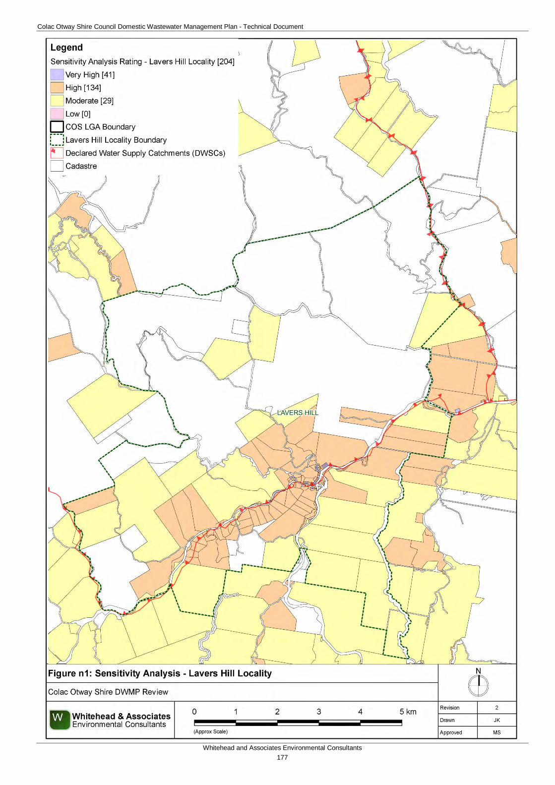
Colac Otway Shire Council Domestic Wastewater Management Plan - Technical Document
Whitehead and Associates Environmental Consultants 177
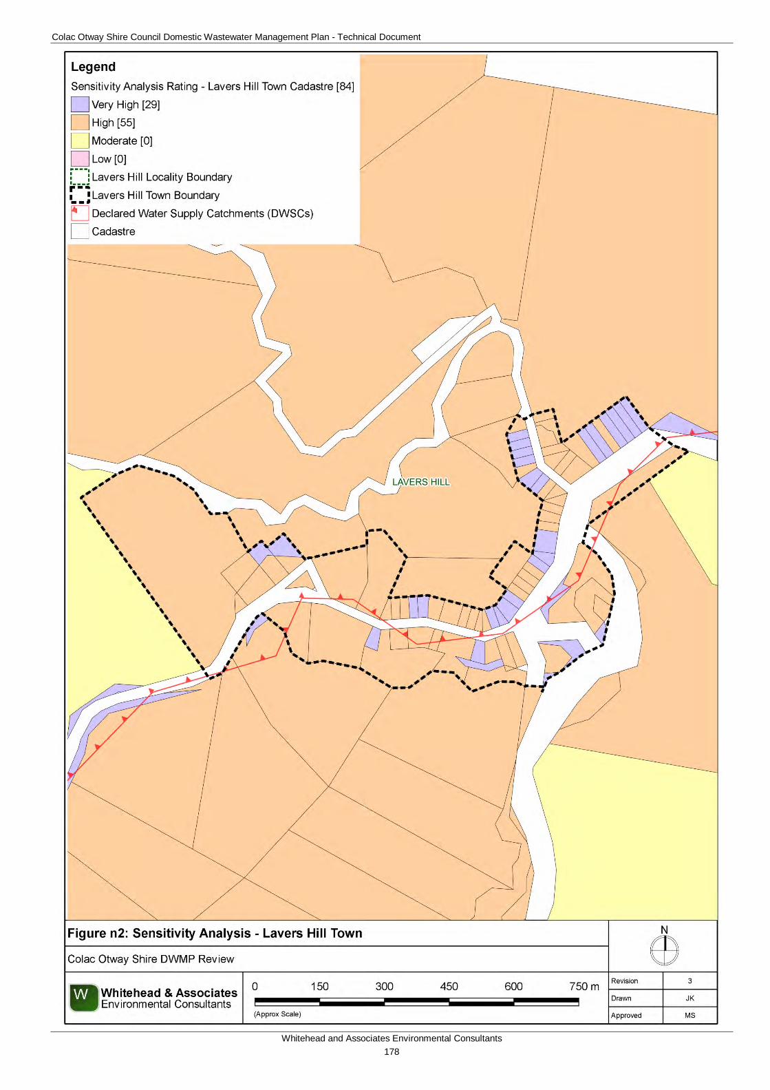
Colac Otway Shire Council Domestic Wastewater Management Plan - Technical Document
Whitehead and Associates Environmental Consultants 178
Colac Otway Shire Council Domestic Wastewater Management Plan - Technical Document
Whitehead and Associates Environmental Consultants 179
6n. System Selection Due to the dominance of heavy-textured soils in the Lavers Hill locality, conventional absorption trenches and beds are not likely to be feasible and are discouraged. Appendix A of the EPA Code of Practice (2013) prohibits LPED systems on Category 5 and 6 soils (medium to heavy clays).
The wet climate of the Lavers Hill area makes it a high risk for DWM and site-specific, detailed land capability assessment and design will be required for unsewered properties/parcels in this area. Mitigation measures (such as importation of topsoil to appropriate depths in the land application area) may be required to sustainably achieve land application of effluent on constrained properties/parcels.
EPA Code of Practice (2013) (Section 2.2.2) identifies secondary treatment standard (or better) followed by subsurface pressure-compensating irrigation as current best-practice in Victoria for substantially reducing the risk associated with unsewered development. Further, the Code describes a “Wick trench/bed” land application option that may be incorporated with secondary treatment for consideration on sites constrained by climate or lot ‘useable area’, particularly within the DWSCs. Any variation from this best-practice approach must be provided with detailed supporting information to demonstrate suitability.
Sizing Tables (discussed below) are not applicable for the Lavers Hill locality.
7n. System Sizing Tables Sizing Tables for each system type were tested using conservative monthly water balances, following methods described in the MAV Model LCA, 2014. Monthly 70th percentile rainfall was sourced from the Wyelangta BoM station (090087) and average evapotranspiration data for Lavers Hill was sourced from SILO (Scientific Information for Land Owners) climate databases, which are managed by the Queensland Government. The SILO databases use accurate meteorological data collected throughout Australia over long time periods.
70th percentile monthly rainfall exceeds average monthly evapotranspiration for the entire ‘design’ climate year in and around Lavers Hill. As a result, there is a month-to-month surplus of hydraulic inputs and subsequently the monthly water balance does not resolve itself and cannot produce meaningful results for land application area sizing.
8n. General Conclusion The majority of the properties/parcels within the locality have been assigned a High Sensitivity Rating to sustainable DWM. Predominantly, Detailed LCAs will be required, with all levels of LCA required to complete a site-specific design due to the higher rainfall associated with this region. System Sizing Tables were not generated for Lavers Hill and site-specific design is required for all properties/parcels that are located within Climate Zone 4, as per Figure 3 of the DWMP Technical Document, and System Sizing Tables cannot be used. Particular attention needs to be directed towards ensuring that the DWM systems are sized based on the limiting soil horizon and that the systems selected are appropriate for steeper slopes with correct construction.
Colac Otway Shire Council Domestic Wastewater Management Plan - Technical Document
Whitehead and Associates Environmental Consultants 180
O. Wye River and Separation Creek Locality Report 1o. Introduction Wye River and Separation Creek are two separate adjacent localities, with respective towns, that are located along the south-eastern coastline of COS approximately 23km northeast of Apollo Bay. They are located in the heavily vegetated foothills of the south-eastern section of the Otway Ranges. The localities are not located within a DWSC.
Previous studies have found that it is not technically feasible to sewer the towns, particularly due to the heavily vegetated steep slopes and landslip potential of the region. Extensive assessment, outlined in the background documentation listed below, has been conducted within this region about the perceived environmental and public health risks in both the Wye River and Separation Creek estuaries associated with DWM systems.
There are approximately 393 and 377 unsewered properties/parcels located within the Wye River locality and town, respectively, and 136 and 121 in the Separation Creek locality and town, respectively. There are 147 and 85 DWM system permits that have been inspected to date by COS for Wye River and Separation Creek respectively. The current DWM permits and their associated treatment system and LAA method within the Wye River and Separation Creek localities are summarised as follows:
Wye River:
• 81 AWTS (24 drip irrigation, 2 trenches, 11 irrigation, 16 subsurface irrigation and 28 unknown);
• 1 composting toilet (1 unknown);
• 31 septic tanks (5 trenches and 26 unknown);
• 5 worm farms (3 trenches and 3 irrigation); and
• 25 unknown (5 drip irrigation, 1 trench, 1 irrigation and 18 unknown).
Separation Creek:
• 34 AWTS (8 drip irrigation, 5 trenches, 4 irrigation, 7 subsurface irrigation, 10 unknown);
• 21 sand filters (21 subsurface irrigation);
• 15 septic tanks (1 subsurface irrigation, 1 trench and 13 unknown); and
• 15 unknown (2 trenches, 2 subsurface irrigation and 11 unknown).
There have been two official complaints relating to DWM systems directed to COS over the past year (2015); failed land application area with improvement directed by COS, and a system failing (odour) and unsuitably sized for intermittent holiday loading.
No field investigations were conducted in the Wye River and Separation Creek localities.
2o. Background Documentation Refer to the following documents for additional detail regarding the localities.
• Wye River and Separation Creek Site Survey Property Reports (November 2013);
Colac Otway Shire Council Domestic Wastewater Management Plan - Technical Document
Whitehead and Associates Environmental Consultants 181
• Wye River and Separation Creek Quantitative Microbial Risk Assessment and Ecological Risk Assessment (September 2014);
• Issues Paper Wastewater Management Wye River and Separation Creek (May 2002);
• Wye River Drainage Reserve Land Management Plan: Assessment and Recommendations (February 2012);
• Colac Otway Shire Coastal Community Revitalisation Project (April 2003);
• Colac Otway Shire, Three Towns Stormwater Management Strategy, Concept Study (October 2004);
• Concept Design for Wye River Separation Creek and Kennett River, (June 2006);
• Kennett River, Wye River and Separation Creek Structure Plans (February 2008);
• GIS Atlas - Climate Paper (June, 2000);
• COS Planning Scheme; and
• Rural Living Strategy (2011).
3o. Summary of Constraints to DWM Characteristic Description
Climate Zone Zone 2.
Surface waterways & catchments
The localities are not located within a DWSC. Both Separation Creek and Wye River form the major waterways within this region and confluence with the Southern Ocean. Additional waterways within Separation Creek include Jamieson Creek and Cumberland River. Additional waterways within Wye River include Monash Gully and Hitchcock Gully.
Groundwater Proximity to groundwater bores: insignificant (only one).
Land subject to inundation
Along the confluences of Wye River and Separation Creek within the towns.
Useable lot area
Town (Locality)
High: WR 330 (334) SC 119 (122)
Moderate: WR 45 (45) SC 1 (4)
Low: WR 2 (11) SC 1 (10)
Compliant: WR 0 (3) SC 0 (0)
Minimum lot size compliance with Planning Scheme Zoning
The localities are predominantly zoned Rural Conservation Zone and Public Conservation and Resource Zone. The towns are predominantly zoned Township Zone.
The majority of properties/parcels are compliant, with only the larger properties/parcels adjacent to the towns non-compliant. These are prescribed minimum lot sizes for subdivisions within the Township Zone, under the provisions of Design and Development Overlay
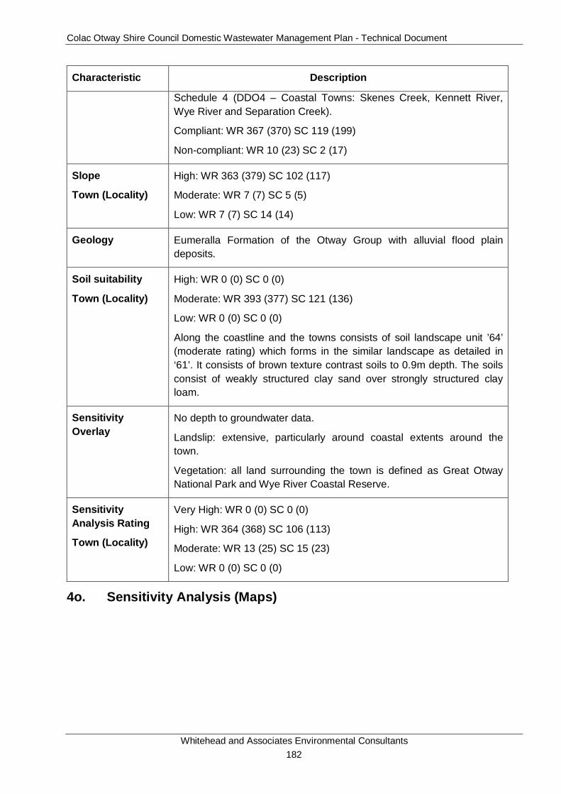
Colac Otway Shire Council Domestic Wastewater Management Plan - Technical Document
Whitehead and Associates Environmental Consultants 182
Characteristic Description
Schedule 4 (DDO4 – Coastal Towns: Skenes Creek, Kennett River, Wye River and Separation Creek).
Compliant: WR 367 (370) SC 119 (199)
Non-compliant: WR 10 (23) SC 2 (17)
Slope
Town (Locality)
High: WR 363 (379) SC 102 (117)
Moderate: WR 7 (7) SC 5 (5)
Low: WR 7 (7) SC 14 (14)
Geology Eumeralla Formation of the Otway Group with alluvial flood plain deposits.
Soil suitability
Town (Locality)
High: WR 0 (0) SC 0 (0)
Moderate: WR 393 (377) SC 121 (136)
Low: WR 0 (0) SC 0 (0)
Along the coastline and the towns consists of soil landscape unit ’64’ (moderate rating) which forms in the similar landscape as detailed in ‘61’. It consists of brown texture contrast soils to 0.9m depth. The soils consist of weakly structured clay sand over strongly structured clay loam.
Sensitivity Overlay
No depth to groundwater data.
Landslip: extensive, particularly around coastal extents around the town.
Vegetation: all land surrounding the town is defined as Great Otway National Park and Wye River Coastal Reserve.
Sensitivity Analysis Rating
Town (Locality)
Very High: WR 0 (0) SC 0 (0)
High: WR 364 (368) SC 106 (113)
Moderate: WR 13 (25) SC 15 (23)
Low: WR 0 (0) SC 0 (0)
4o. Sensitivity Analysis (Maps)
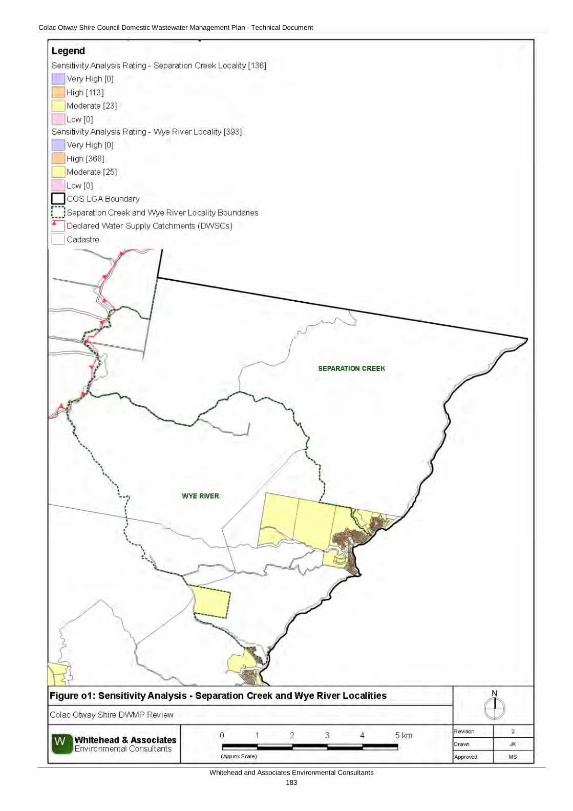
Colac Otway Shire Council Domestic Wastewater Management Plan - Technical Document
Whitehead and Associates Environmental Consultants 183
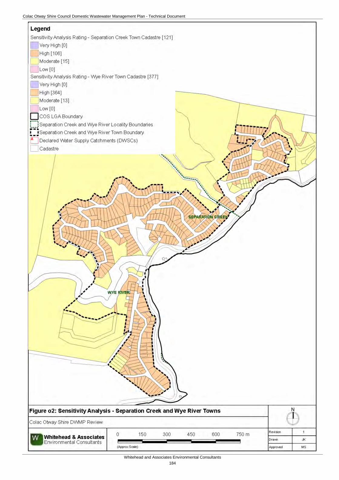
Colac Otway Shire Council Domestic Wastewater Management Plan - Technical Document
Whitehead and Associates Environmental Consultants 184
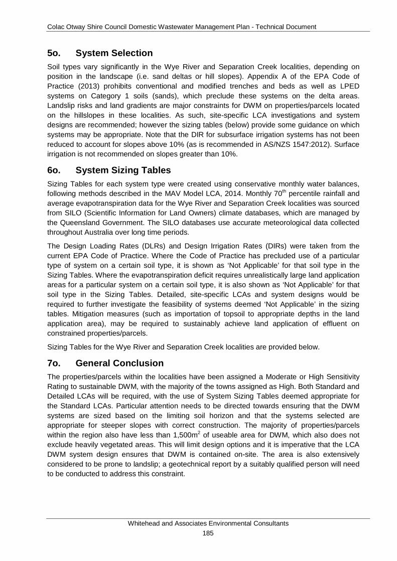
Colac Otway Shire Council Domestic Wastewater Management Plan - Technical Document
Whitehead and Associates Environmental Consultants 185
5o. System Selection Soil types vary significantly in the Wye River and Separation Creek localities, depending on position in the landscape (i.e. sand deltas or hill slopes). Appendix A of the EPA Code of Practice (2013) prohibits conventional and modified trenches and beds as well as LPED systems on Category 1 soils (sands), which preclude these systems on the delta areas. Landslip risks and land gradients are major constraints for DWM on properties/parcels located on the hillslopes in these localities. As such, site-specific LCA investigations and system designs are recommended; however the sizing tables (below) provide some guidance on which systems may be appropriate. Note that the DIR for subsurface irrigation systems has not been reduced to account for slopes above 10% (as is recommended in AS/NZS 1547:2012). Surface irrigation is not recommended on slopes greater than 10%.
6o. System Sizing Tables Sizing Tables for each system type were created using conservative monthly water balances, following methods described in the MAV Model LCA, 2014. Monthly 70th percentile rainfall and average evapotranspiration data for the Wye River and Separation Creek localities was sourced from SILO (Scientific Information for Land Owners) climate databases, which are managed by the Queensland Government. The SILO databases use accurate meteorological data collected throughout Australia over long time periods.
The Design Loading Rates (DLRs) and Design Irrigation Rates (DIRs) were taken from the current EPA Code of Practice. Where the Code of Practice has precluded use of a particular type of system on a certain soil type, it is shown as ‘Not Applicable’ for that soil type in the Sizing Tables. Where the evapotranspiration deficit requires unrealistically large land application areas for a particular system on a certain soil type, it is also shown as ‘Not Applicable’ for that soil type in the Sizing Tables. Detailed, site-specific LCAs and system designs would be required to further investigate the feasibility of systems deemed ‘Not Applicable’ in the sizing tables. Mitigation measures (such as importation of topsoil to appropriate depths in the land application area), may be required to sustainably achieve land application of effluent on constrained properties/parcels.
Sizing Tables for the Wye River and Separation Creek localities are provided below.
7o. General Conclusion The properties/parcels within the localities have been assigned a Moderate or High Sensitivity Rating to sustainable DWM, with the majority of the towns assigned as High. Both Standard and Detailed LCAs will be required, with the use of System Sizing Tables deemed appropriate for the Standard LCAs. Particular attention needs to be directed towards ensuring that the DWM systems are sized based on the limiting soil horizon and that the systems selected are appropriate for steeper slopes with correct construction. The majority of properties/parcels within the region also have less than 1,500m2 of useable area for DWM, which also does not exclude heavily vegetated areas. This will limit design options and it is imperative that the LCA DWM system design ensures that DWM is contained on-site. The area is also extensively considered to be prone to landslip; a geotechnical report by a suitably qualified person will need to be conducted to address this constraint.
Colac Otway Shire Council Domestic Wastewater Management Plan - Technical Document
Whitehead and Associates Environmental Consultants 186
Soil Category Gravels & Sands (1) Sandy Loams (2) Loams (3) Clay Loams (4) Light Clays (5) Medium to Heavy
Clays (6)DIR (mm) 5 5 4 3.5 3
Development Type Daily (L/day)5 + bedroom residence 1,080 480 616 8624 bedroom residence 900 400 514 718
1-3 bedroom residence 720 320 411 575
† not including spacing or setbacks
Soil Category Gravels & Sands (1) Sandy Loams (2) Loams (3)
Weak Loams & High/Mod Clay Loams (3 & 4)
Weak Clay Loams (4) Light Clays (5) Massive Clay
Loams (4)Medium to Heavy
Clays (6)
DLR (mm) 20* 20* 15 10 6 5 4Development Type Daily (L/day) Total min. basal or 'wetted area' required for zero wet weather storage (m2) not including spacing or setbacks
5 + bedroom residence 1,080 84 136 274 366 5534 bedroom residence 900 70 114 228 305 461
1-3 bedroom residence 720 56 91 183 244 369
Soil Category Gravels & Sands (1) Sandy Loams (2) Loams (3a) Weak/Massive
Loams (3b)High/Mod Clay
Loams (4a)
Weak Clay Loams (4b) & Strong
Light Clays (5a)
Massive Clay Loams (4c) and
Mod & Weak Light Clays (5b, 5c)
Medium to Heavy Clays (6) - Secondary
Effluent Only
DLR (mm) 20* 20* 15 10 12 8 5 5Development Type Daily (L/day)
5 + bedroom residence 1,080 84 136 109 1824 bedroom residence 900 70 114 91 152
1-3 bedroom residence 720 56 91 73 121
Soil Category Gravels & Sands (1) Sandy Loams (2) Loams (3) Clay Loams (4) Light Clays (5) Medium to Heavy
Clays (6)DIR (mm) 4 3.5 3
Development Type Daily (L/day)5 + bedroom residence 1,080 553 743 1,1334 bedroom residence 900 461 620 944
1-3 bedroom residence 720 369 496 755
Soil Category Gravels & Sands (1)
Sandy Loams (2) Loams (3) &
High/Mod Clay Loams (4a,b)
Weak Clay Loams (4)
Massive Clay Loams (4)
Strong Light Clays (5a)
Moderate Light Clays (5b)
Weak Light Clays (5c)
Medium to Heavy Clays (6)
DLR (mm) 25 30 20 10 12 8 8 5Development Type Daily (L/day)
5 + bedroom residence 1,080 48 39 61 136 109 3664 bedroom residence 900 40 33 51 114 91 305
1-3 bedroom residence 720 32 26 41 91 73 244
305244
N/A (Alternative Land
Application System Required)
Note: * irrigation system sizes are based on the assumption that the land application area is less than 10% slope. Reductions in DIR apply for slopes above 10% according to Table M2 of AS1547:2012
N/A (Alternative Land
Application System Required)
615141
Note: * Gravels, Sands and sandy loams are unsuitable for conventional absorption trenches and beds if there is a high watertable, including seasonal and perched watertables. Value based on average of conservative rate and maximum rate for Category 2b and 3a soils in AS1547:2012
Drip and Spray Irrigation Systems* - Secondary Treated Effluent only - Slopes or Sand Delta
LPED Irrigation Systems - Primary or Secondary Treated Effluent - Slopes only (not Sand Delta)
332277222
41
Total min. irrigation area required for zero wet weather effluent storage (m2)†
Wick Trenches and Beds - Secondary Treated Effluent Only - Slopes or Sand Delta
Conventional Absorption Trenches and Beds - Primary Treated Effluent - Slopes only (not Sand Delta)
Note: * Gravels, Sands and sandy loams are unsuitable for conventional absorption trenches and beds if there is a high watertable, including seasonal and perched watertables. Value based on average of conservative rate and maximum rate for Category 2b and 3a soils in AS1547:2012
51
N/A (Alternative Land
Application System Required)
† required for zero wet weather storage (m2) not including spacing & setbacks
Total min. basal or 'wetted area'†
61Total min. basal or 'wetted area' required for zero wet weather storage (m2) not including spacing & setbacks
366
N/A (Alternative Land
Application System Required)
N/A (Alternative Land
Application System Required)
Evapotranspiration-Absorption Trenches and Beds - Primary Treated Effluent (Category 1 to 5) and Secondary Treated Effluent only (Category 6) - Slopes only (not sand delta)
Wye River and Separation Creek
121
182152
Total min. basal or 'wetted area' required for zero wet weather storage (m2) not including spacing & setbacks

Colac Otway Shire Council Domestic Wastewater Management Plan - Technical Document
Whitehead and Associates Environmental Consultants 187
Appendix C
Acceptable Monthly Climate Data
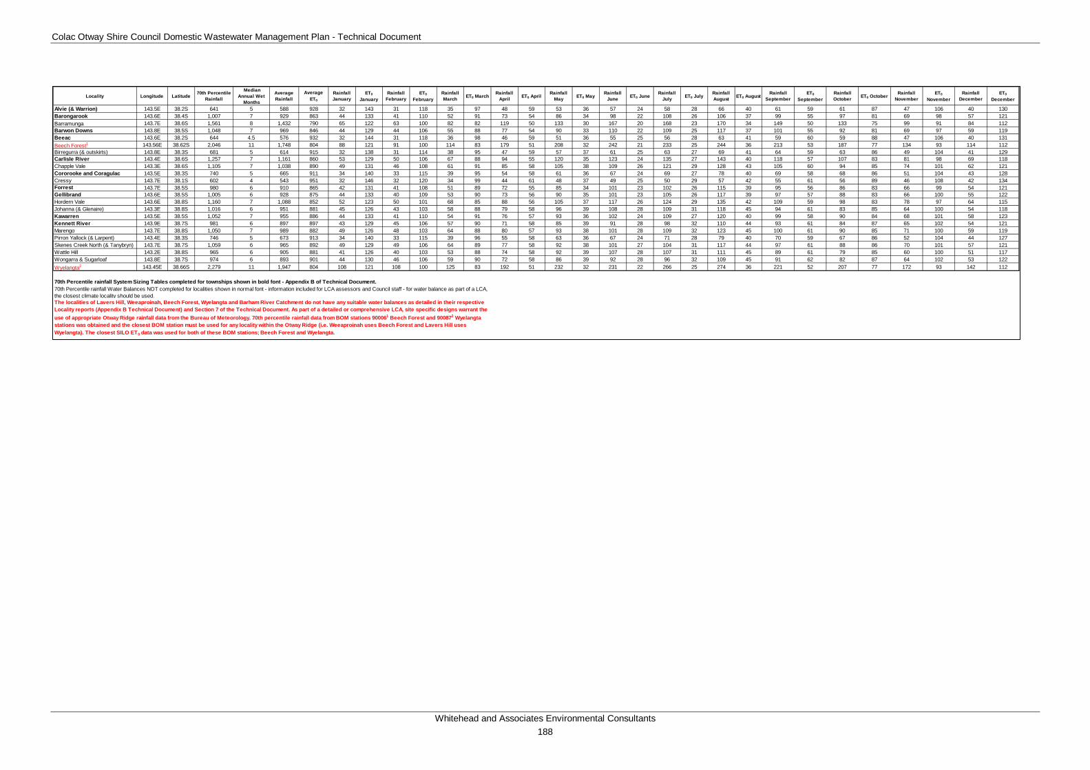
Colac Otway Shire Council Domestic Wastewater Management Plan - Technical Document
Whitehead and Associates Environmental Consultants 188
Locality Longitude Latitude 70th Percentile Rainfall
Median Annual Wet
Months
Average Rainfall
Average ET0
Rainfall January
ET0
JanuaryRainfall
FebruaryET0
FebruaryRainfall March ET0 March Rainfall
April ET0 April Rainfall May ET0 May Rainfall
June ET0 June Rainfall July ET0 July Rainfall
August ET0 August Rainfall September
ET0
SeptemberRainfall October ET0 October Rainfall
NovemberET0
NovemberRainfall
DecemberET0
December
Alvie (& Warrion) 143.5E 38.2S 641 5 588 928 32 143 31 118 35 97 48 59 53 36 57 24 58 28 66 40 61 59 61 87 47 106 40 130Barongarook 143.6E 38.4S 1,007 7 929 863 44 133 41 110 52 91 73 54 86 34 98 22 108 26 106 37 99 55 97 81 69 98 57 121Barramunga 143.7E 38.6S 1,561 8 1,432 790 65 122 63 100 82 82 119 50 133 30 167 20 168 23 170 34 149 50 133 75 99 91 84 112Barwon Downs 143.8E 38.5S 1,048 7 969 846 44 129 44 106 55 88 77 54 90 33 110 22 109 25 117 37 101 55 92 81 69 97 59 119Beeac 143.6E 38.2S 644 4.5 576 932 32 144 31 118 36 98 46 59 51 36 55 25 56 28 63 41 59 60 59 88 47 106 40 131Beech Forest1 143.56E 38.62S 2,046 11 1,748 804 88 121 91 100 114 83 179 51 208 32 242 21 233 25 244 36 213 53 187 77 134 93 114 112Birregurra (& outskirts) 143.8E 38.3S 681 5 614 915 32 138 31 114 38 95 47 59 57 37 61 25 63 27 69 41 64 59 63 86 49 104 41 129Carlisle River 143.4E 38.6S 1,257 7 1,161 860 53 129 50 106 67 88 94 55 120 35 123 24 135 27 143 40 118 57 107 83 81 98 69 118Chapple Vale 143.3E 38.6S 1,105 7 1,038 890 49 131 46 108 61 91 85 58 105 38 109 26 121 29 128 43 105 60 94 85 74 101 62 121Cororooke and Coragulac 143.5E 38.3S 740 5 665 911 34 140 33 115 39 95 54 58 61 36 67 24 69 27 78 40 69 58 68 86 51 104 43 128Cressy 143.7E 38.1S 602 4 543 951 32 146 32 120 34 99 44 61 48 37 49 25 50 29 57 42 55 61 56 89 46 108 42 134Forrest 143.7E 38.5S 980 6 910 865 42 131 41 108 51 89 72 55 85 34 101 23 102 26 115 39 95 56 86 83 66 99 54 121Gellibrand 143.6E 38.5S 1,005 6 928 875 44 133 40 109 53 90 73 56 90 35 101 23 105 26 117 39 97 57 88 83 66 100 55 122Hordern Vale 143.6E 38.8S 1,160 7 1,088 852 52 123 50 101 68 85 88 56 105 37 117 26 124 29 135 42 109 59 98 83 78 97 64 115Johanna (& Glenaire) 143.3E 38.8S 1,016 6 951 881 45 126 43 103 58 88 79 58 96 39 108 28 109 31 118 45 94 61 83 85 64 100 54 118Kawarren 143.5E 38.5S 1,052 7 955 886 44 133 41 110 54 91 76 57 93 36 102 24 109 27 120 40 99 58 90 84 68 101 58 123Kennett River 143.9E 38.7S 981 6 897 897 43 129 45 106 57 90 71 58 85 39 91 28 98 32 110 44 93 61 84 87 65 102 54 121Marengo 143.7E 38.8S 1,050 7 989 882 49 126 48 103 64 88 80 57 93 38 101 28 109 32 123 45 100 61 90 85 71 100 59 119Pirron Yallock (& Larpent) 143.4E 38.3S 746 5 673 913 34 140 33 115 39 96 55 58 63 36 67 24 71 28 79 40 70 59 67 86 52 104 44 127Skenes Creek North (& Tanybryn) 143.7E 38.7S 1,059 6 965 892 49 129 49 106 64 89 77 58 92 38 101 27 104 31 117 44 97 61 88 86 70 101 57 121Wattle Hill 143.2E 38.8S 965 6 905 881 41 126 40 103 53 88 74 58 92 39 107 28 107 31 111 45 89 61 79 85 60 100 51 117Wongarra & Sugarloaf 143.8E 38.7S 974 6 893 901 44 130 46 106 59 90 72 58 86 39 92 28 96 32 109 45 91 62 82 87 64 102 53 122Wyelangta2 143.45E 38.66S 2,279 11 1,947 804 108 121 108 100 125 83 192 51 232 32 231 22 266 25 274 36 221 52 207 77 172 93 142 112
70th Percentile rainfall System Sizing Tables completed for townships shown in bold font - Appendix B of Technical Document.
The localities of Lavers Hill, Weeaproinah, Beech Forest, Wyelangta and Barham River Catchment do not have any suitable water balances as detailed in their respective Locality reports (Appendix B Technical Document) and Section 7 of the Technical Document. As part of a detailed or comprehensive LCA, site specific designs warrant the use of appropriate Otway Ridge rainfall data from the Bureau of Meteorology. 70th percentile rainfall data from BOM stations 900061 Beech Forest and 900872 Wyelangta stations was obtained and the closest BOM station must be used for any locality within the Otway Ridge (i.e. Weeaproinah uses Beech Forest and Lavers Hill uses Wyelangta). The closest SILO ET0 data was used for both of these BOM stations; Beech Forest and Wyelangta.
70th Percentile rainfall Water Balances NOT completed for localities shown in normal font - information included for LCA assessors and Council staff - for water balance as part of a LCA, the closest climate locality should be used.