Embed Size (px)
Citation preview

1
White Oak Science Gateway Master Plan Abstract This Plan contains the text and supporting maps for a comprehensive amendment to portions of the approved and adopted 1997 White Oak Master Plan and portions of the approved and adopted 1997 Fairland Master Plan, as amended. It also amends The General Plan (On Wedges and Corridors) for the Physical Development of the Maryland-Washington Regional District in Montgomery and Prince George’s Counties, as amended; the Master Plan of Highways within Montgomery County, as amended; and the Countywide Bikeways Functional Master Plan, as amended. This Plan cover nearly 3,000 acres and makes recommendations for land use, density, zoning, transportation, environment, historic resources, and community facilities. Source of Copies The Maryland-National Capital Park and Planning Commission 8787 Georgia Avenue Silver Spring, MD 20910-3760 Online at: www.montgomeryplanning.org/community/wosg Master and sector plans convey land use policy for defined geographic areas and should be interpreted together with relevant Countywide functional plans and County laws and regulations. Plan recommendations provide comprehensive guidelines for the use of public and private land and should be referred to by public officials and private individuals when making land use decisions. Public and private land use decisions that promote plan goals are essential to fulfilling a plan’s vision. Master and sector plans look ahead 20 years from the date of adoption, although they are intended to be revised every 10 to 15 years. Moreover, circumstances when a plan is adopted will change and the specifics of a plan may become less relevant over time. Plans do not specify all development possibilities. Their sketches are for illustrative purposes only, intended to convey a sense of desirable future character rather than a recommendation for a particular design. The Maryland-National Capital Park and Planning Commission The Maryland-National Capital Park and Planning Commission is a bi-county agency created by the General Assembly of Maryland in 1927. The Commission’s geographic authority extends to the great majority of Montgomery and Prince George’s Counties; the Maryland-Washington Regional District (M-NCPPC planning jurisdiction) comprises 1,001 square miles, while the Metropolitan District (parks) comprises 919 square miles, in the two counties. The Commission is charged with preparing, adopting, and amending or extending The General Plan (On Wedges and Corridors) for the Physical Development of the Maryland-Washington Regional District in Montgomery and Prince George’s Counties.
2
The Commission operates in each county through Planning Boards appointed by the county government. The Boards are responsible for all local plans, zoning amendments, subdivision regulations, and administration of parks. The Maryland-National Capital Park and Planning Commission encourages the involvement and participation of individuals with disabilities, and its facilities are accessible. For assistance with special needs (e.g., large print materials, listening devices, sign language interpretation, etc.), please contact the Community Outreach office, 301-495-4600 or TDD 301-495-1331.
3
WHITE OAK SCIENCE GATEWAY STAFF DRAFT MASTER PLAN Contents VISION .................................................................................................................................... 7 OVERVIEW .............................................................................................................................. 9
Master Plan Area ....................................................................................................... 9 Community Outreach................................................................................................. 9 White Oak Today........................................................................................................ 9
BACKGROUND ........................................................................................................................ 13 Demographics ............................................................................................................ 13 Planning History ......................................................................................................... 14
The General Plan ............................................................................................ 14 Previous Master Plans .................................................................................... 15
THE PLAN ................................................................................................................................ 19 Opportunities and Challenges ................................................................................... 19 Land Use Supported by Transit .................................................................................. 20 Land Use-Transportation Balance .............................................................................. 22
LAND USE AND ZONING ......................................................................................................... 25 Proposed Development and Zoning Overview .......................................................... 28 White Oak/FDA Center .............................................................................................. 32
The Federal Research Center and the Food and Drug Administration.......... 32 Commercial Properties .................................................................................. 32 Residential Properties .................................................................................... 35 Zoning Recommendations ............................................................................. 36
Hillandale Community................................................................................................ 37 Zoning Recommendations ............................................................................. 39
North White Oak/Cherry Hill Road Center ................................................................ 41 Existing Public Uses ........................................................................................ 42 Existing Industrial Uses .................................................................................. 42 1997 Zoning.................................................................................................... 43 Percontee/Site 2 ............................................................................................ 43 Mobility .......................................................................................................... 45 Zoning Recommendations ............................................................................. 46
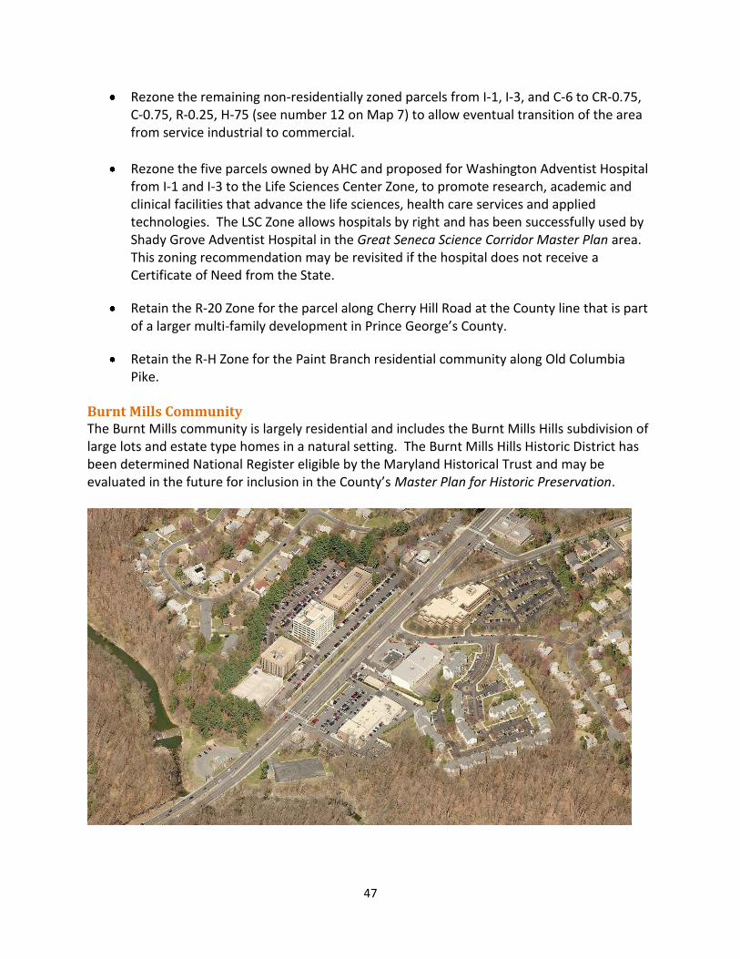
Burnt Mills Community .............................................................................................. 47 Zoning Recommendations ............................................................................. 48
TRANSPORTATION ................................................................................................................. 49 Traffic Modeling Analysis ........................................................................................... 50 The Street Network .................................................................................................... 55 Transit Network ......................................................................................................... 59 The Bikeway Network and Pedestrian Circulation .................................................... 62 Travel Demand Management .................................................................................... 64
4
NATURAL ENVIRONMENT ...................................................................................................... 67 Overall Goal ................................................................................................................ 67 Resource Protection and Preservation ...................................................................... 67 Water Quality ............................................................................................................. 68 Air Quality/Climate Protection .................................................................................. 71 Specific Property Recommendations ......................................................................... 71
HISTORIC RESOURCES ............................................................................................................ 73 Objective .................................................................................................................... 73 White Oak’s Historic Context ..................................................................................... 73 Potential Historic Resources for Future Evaluation ................................................... 76 Previously Designated Historic Resource .................................................................. 77 Site Recommended to be added to Locational Atlas and Designated in Master Plan for Historic Preservation .................................................................... 78
COMMUNITY FACILITIES ........................................................................................................ 81 Park, Open Spaces, and Recreation ........................................................................... 81
Existing Parks ................................................................................................. 81 Park, Recreation, and Open Space Needs ..................................................... 83 Park, Recreation, and Open Space (PROS) Plan ............................................. 84 Parks Recommendations ............................................................................... 84 Parks Recommendations for Centers ............................................................ 85
Public Schools ............................................................................................................ 88 Libraries ...................................................................................................................... 89 Recreation Centers .................................................................................................... 90 Police .......................................................................................................................... 90 Fire, Rescue, and Emergency Medical Services ......................................................... 90 Regional Services Center ............................................................................................ 91 CHI Centers ................................................................................................................ 91
IMPLEMENTATION AND STAGING ......................................................................................... 93 Staging Overview ....................................................................................................... 93 Staging Requirements ................................................................................................ 94 Sectional Map Amendment ....................................................................................... 99 Design Guidelines ....................................................................................................... 99 Public Benefits in the CR Zone ................................................................................... 99 Financing Mechanisms ............................................................................................... 100 County Capital Improvements Program .................................................................... 102
Maps Map 1 Master Plan and Study Area Boundaries ....................................................... 10 Map 2 Existing Development .................................................................................... 11 Map 3 General Plan: Wedges and Corridors ............................................................. 15 Map 4 Existing Land Use ........................................................................................... 26 Map 5 Centers ........................................................................................................... 27 Map 6 Existing Zoning ............................................................................................... 30 Map 7 Proposed Zoning ............................................................................................ 31
5
Map 8 White Oak/FDA Center: Existing Uses ........................................................... 34 Map 9 Hillandale Community: Existing Uses ............................................................. 39 Map 10 North White Oak/Cherry Hill Road Center: Existing Uses ............................. 44 Map 11 Burnt Mills Community: Existing Uses ........................................................... 48 Map 12 Street Network ............................................................................................... 58 Map 13 Bus Rapid Transit Conceptual Alignments ..................................................... 61 Map 14 Existing and Proposed Bikeways and Trails ................................................... 63 Map 15 Watersheds and Streams ............................................................................... 69 Map 16 Community Facilities and Historic Sites ......................................................... 82
Figures Figure 1 Overall Illustrative .......................................................................................... 21 Figure 2 White Oak/FDA Center Illustrative Concept .................................................. 35 Figure 3 Hillandale Community Illustrative Concept ................................................... 40 Figure 4 North White Oak/Cherry Hill Road Illustrative Concept ................................ 45 Figure 5 TPAR Analysis Results .................................................................................... 53 Figure 6 TPAR Analysis Results Excluding US 29 Traffic ............................................... 54 Tables Table 1 Existing and Proposed Zoning ........................................................................ 29 Table 2 Standards of Acceptable Roadway Average Level of Service ........................ 53 Table 3 Street and Highway Classifications ................................................................ 56 Table 4 Bikeway Facilities ........................................................................................... 62 Table 5 Existing and Potential Development .............................................................. 94 Table 6 Staging Plan Summary ................................................................................... 98 Appendix (Published under separate cover with the Public Hearing Draft)
A. Transportation Background B. Transit Analysis by Martin Alexiou Bryson C. White Oak Rental Housing Affordability Analysis D. Commercial Market Analysis by Partners for Economic Solutions E. Park Classification System

6
7
VISION Reimagining existing centers – and providing a framework for reinvestment - is vital to this community’s longevity. This Plan seeks to leverage White Oak’s assets and establish the foundation upon which the area can evolve into a community that offers more opportunities to live-work-play locally. One of this area’s greatest strengths is the consolidated headquarters of the Food and Drug Administration (FDA) at the White Oak Federal Research Center (FRC). FDA brings thousands of employees and visitors to its state-of-the art campus, presenting synergistic opportunities to reimagine and rethink the possibilities for surrounding communities. FDA could serve as a gateway to attract companies that offer high quality employment in fields such as health care, pharmaceuticals, life sciences, and advanced technology. The Plan envisions White Oak’s major centers – Hillandale, White Oak/FDA, and North White Oak/Cherry Hill - evolving from conventional, auto-dependent suburban shopping centers, business parks, and light industrial areas into vibrant, mixed-use, transit-served nodes. Redevelopment of the centers must be carefully integrated with existing residential neighborhoods and designed to enhance the entire area’s quality of life, appearance, walkability, and sense of place. Existing residential neighborhoods will be maintained and enhanced within a physical environment that meets the community’s needs and aspirations. This Plan provides a blueprint to connect White Oak’s centers to each other and the broader region through a transit system. An enhanced open space, trail, and bikeway network that incorporates the area’s natural environmental features will provide opportunities for a range of outdoor experiences.

8
9
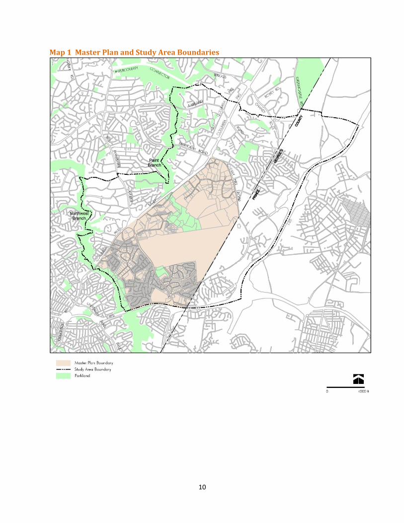
OVERVIEW Master Plan Area The White Oak Science Gateway (WOSG) Master Plan area covers nearly 3,000 acres and is bounded by the Capital Beltway (I-495) on the south, Northwest Branch Stream Valley Park on the west, US 29 and Cherry Hill Road on the north, and Prince George’s County on the east (see Map 1). Community Outreach As part of the overall outreach strategy for the Plan, the scope of work recommended that a Citizens Advisory Committee (CAC) be formed to work with staff in developing the Plan. The Planning Board appointed a 23-member CAC and twelve CAC meetings were held over 15 months with approximately 70 percent attendance by appointed members and roughly 20 additional attendees per meeting. In addition to CAC meetings, staff held four community forums to provide information and solicit input from the broader community and these meetings averaged 70 participants each. Staff also attended 15 civic association meetings to present information, receive community input, and answer questions about the Master Plan. Staff created an e-mail distribution list of over 500 contacts who received notices of all meetings. The web page for the Master Plan (www.montgomeryplanning.org/community/wosg/) contains extensive information, including PowerPoint presentations from CAC meetings. In addition, a questionnaire was created to get additional input about the White Oak area from community members. Staff coordinated with public sector stakeholders, including the Montgomery County Department of Transportation, the Montgomery County Department of Economic Development, and Montgomery County Public Schools. Staff held interagency meetings focused on transportation that included Prince George’s County and the Maryland State Highway Administration. Staff worked with the CAC as well as the larger community in developing the Master Plan vision and a set of preliminary recommendations. With input from stakeholders, staff prepared a land use alternative for possible future development and conducted traffic modeling to analyze potential impacts on the local road network. White Oak Today The most significant new development in this area in the past 15 years has been the consolidation of the Food and Drug Administration (FDA) Headquarters at the Federal Research Center (FRC) at White Oak (see Map 2). The FDA occupies 130 acres on the New Hampshire Avenue side of the FRC, and construction of the campus has been underway since 2001.
10
Map 1 Master Plan and Study Area Boundaries
11
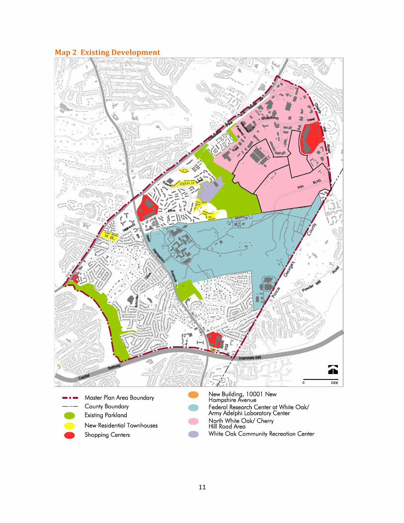
Map 2 Existing Development
12
In Hillandale, a new office building was completed in 2010 (10001 New Hampshire Avenue) that is leased by the FDA. After 41 years at its site in Hillandale, the National Labor College site is for sale. A former furniture store on US 29 just north of Northwest Branch was redeveloped in 2005 as the Shoppes of Burnt Mills, anchored by Trader Joe’s. New residential developments include three townhouse communities built since 2000 – Gatestone and Whitehall Square off Stewart Lane and Seaton Square off Lockwood Drive. In North White Oak/Cherry Hill, the “big box” Orchard Center retail on Cherry Hill Road opened in the late 1990s, the restaurant-oriented Westech Village Corner on Tech Road opened in 2006, and there are two new hotels, Marriott Residence Inn and Hilton Garden Inn. Two office buildings were built on Plum Orchard Drive in the Westech Business Park in the 2000s. The newly opened White Oak Community Recreation Center (recommended in the 1997 White Oak Master Plan), located at 1700 April Lane, includes an outdoor skateboard area and a small athletic field. The 1997 Fairland Master Plan recommended two parcels be acquired on Old Columbia Pike to create a small park; these parcels were purchased and the 4.4-acre Stonehedge Local Park includes two playgrounds, a basketball court, and a small multi-use field. Just outside the Master Plan boundary, on the northeast quadrant of the New Hampshire Avenue/US 29 interchange, the Third District Police Station is under construction on Milestone Drive. The new station, scheduled to open in 2013, will replace the current facility at 801 Sligo Avenue in Silver Spring.
13
BACKGROUND Demographics A study area was created to have a larger context than the Plan area for demographic data collection and analysis. The study area boundary is roughly I-495 on the south, Northwest Branch and Paint Branch on the west, the Intercounty Connector (ICC) on the north, and I-95 on the east (see Map 1). Based on the Planning Department’s 2008 Census Update Survey, the WOSG study area (Montgomery County portion only) has an estimated population of 35,655 persons in 14,195 households, with an average household size of 2.5 persons. The average age of residents is 37.5 years, with slightly more children and slightly fewer “baby boomers” than the County as a whole. The average age of the head of the household is 51 years, which is identical to the County average. Nearly two-thirds (64 percent) of study area housing units are owner-occupied, which is less than the Countywide homeownership rate of 75 percent. Renters account for 36 percent of households in the area. There is a larger share of single-person households (31 percent) and fewer families (68 percent) than there are Countywide. This household data reflects the relatively large multi-family housing stock in the area; 43 percent of the residential units are multi-family and 57 percent are single-family. The study area’s 2007 median household income was $75,400, about 22 percent below the Countywide median ($96,475), but consistent with the larger share of single-person households and, consequently, fewer dual-income households. Housing costs, particularly homeownership costs, are lower in the study area than the County as a whole. Study area residents paid 23 percent less for monthly mortgage payments ($1,711) than the typical County homeowner ($2,188). At $1,242 per month, rental costs are only about seven percent less than the County average of $1,327. However, study area renters are particularly cost-burdened, with 42 percent spending more than 30 percent of their income on housing. With regard to ethnicity, 39 percent of residents in the study area are African American (compared to 16 percent Countywide) and 36 percent are white (compared to 54 percent Countywide). Compared to the County overall, the study area has fewer Hispanic (14 percent versus 16 percent) and Asian (9 percent versus 13 percent) residents. The percentage of foreign-born residents in the study area is almost identical to the County (30 percent versus 29 percent), although a larger proportion of area residents speak a language other than English at home (42 percent versus 38 percent). Study area residents are very well educated, with 64 percent of adults ages 25 and up having earned at least a bachelor’s degree, compared to 66 percent Countywide and 28 percent nationwide. Compared to the typical employed resident in the County, the study area’s employed residents are somewhat more likely to work for federal, state, or local government (27 percent versus 25 percent) and somewhat less likely to work in the private sector (38 percent versus 44 percent).

14
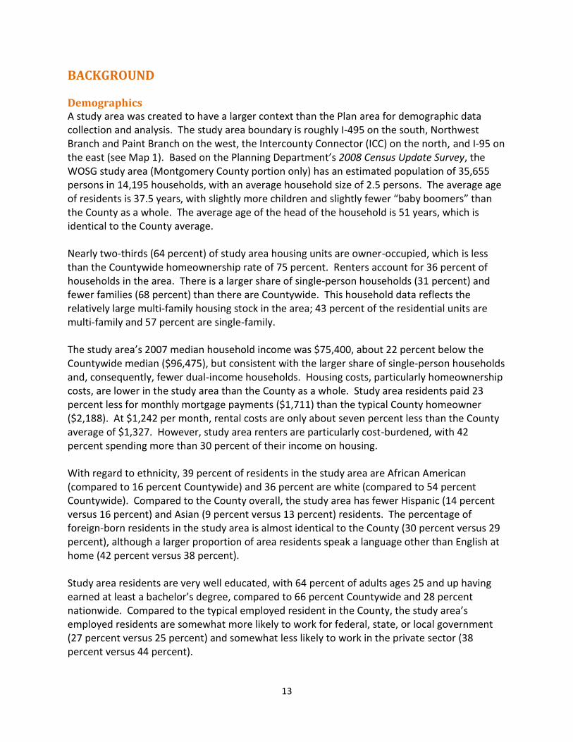
Commuting patterns in the study area vary markedly from the County as a whole. Area workers are more auto-dependent (75 percent commute alone by car compared to 69 percent Countywide) with longer than average commute times (nearly an hour). While the number of residents who commute to jobs in Washington, D.C. is about the same as the County as a whole (24 percent versus 23 percent), fewer study area residents work in Montgomery County than Countywide (49 percent versus 59 percent). At the same time, a higher percentage of residents in the study area work in Prince George’s County (13 percent of study area residents versus 5 percent of County residents). Some federal and university job centers in Prince George’s County provide more convenient locations for study area residents than jobs within Montgomery County. The rates of public transit usage are lower than the County as a whole (16 percent versus 18 percent) as is the percent of those who commute to work by walking or biking (.8 percent compared to 3.5 percent). Planning History The General Plan The 1993 General Plan Refinement divides the County into four geographic areas: the relatively intensively developed down-County urban ring; the I-270 Corridor; the moderately dense suburban communities; and the low-density residential and rural agricultural wedges (see Map 3). In this Plan area, Burnt Mills, the White Oak Shopping Center and vicinity, and Hillandale are within the urban ring and North White Oak/Cherry Hill Road, the area north of the Paint Branch Stream Valley Park, is within the suburban communities. The recommendations in this Master Plan are consistent with the General Plan’s goals for the urban ring and suburban communities. The General Plan vision for the urban ring is:
well-established, lively centers with job and housing opportunities
strong residential neighborhoods
varied transit options
relatively dense development
active public and private reinvestment
commercial revitalization.
The General Plan vision for the suburban communities is:
moderate density land uses which are transit serviceable along major arteries
increasing transportation options
suburban residential neighborhoods
distinct centers
appropriate public and private investment.
15
Map 3 General Plan: Wedges and Corridors
Previous Master Plans The 1981 Eastern Montgomery County Planning Area: Cloverly, Fairland, White Oak devised a concept called “transit serviceability” that envisioned concentrating development where it could be served by transit (buses). Future growth would be directed to defined centers with densities that would ultimately justify public investment in substantial, high quality transit. Commuter parking lots at these centers would enable auto drivers to transfer to buses or carpools. The Plan explored options that included reconstructing a portion of US 29 as a
16
freeway, dedicating lanes for exclusive use of buses/carpools during the peak periods, and constructing a light rail (or other exclusive right-of-way) transit system to connect Burtonsville with the Wheaton Metro Station. These options were considered either unworkable or too expensive. “After giving detailed consideration to the light-rail concept, the Planning Board eliminated it…Projections of ridership were within ranges which could be served by a high-level express bus system.” (page 169) By 1986, the Fairland/White Oak Policy Area was in a development moratorium due to a lack of road capacity. During the 1980s, the State Highway Administration (SHA) added capacity to US 29 through several projects. Despite these improvements, traffic congestion in the area reached unacceptable levels based on the Annual Growth Policy guidelines. In 1990, the County Council adopted a Trip Reduction Amendment to the 1981 Master Plan as an interim measure to reduce potential growth until a comprehensive master plan could be undertaken that would address the transportation infrastructure imbalance. In the 1990s, four eastern County master plans were prepared simultaneously: Four Corners, White Oak, Fairland, and Cloverly. All of the WOSG Plan area was previously part of the 1997 White Oak Master Plan except for the portion north of the Paint Branch Stream Valley Park and south of Cherry Hill Road, which was in the 1997 Fairland Master Plan and was referred to as the US 29/Cherry Hill Road Employment Area. The 1997 White Oak Master Plan envisioned the area remaining residential, with any infill development following the established pattern. Commercial areas would be attractive, pedestrian-friendly, multi-purpose centers for daily retail services. Any redevelopment within the centers would enhance the communities, but the character and density of the neighborhoods would not appreciably change. The 1997 Fairland Master Plan recommended that the area remain suburban and outside the area influenced by the I-95 corridor. Employment and commercial areas would include horizontal rather than vertical structures. The Plan’s concept for residential communities emphasized suburban densities and single-family detached housing surrounded by a system of open spaces and greenways. For the major commercial/industrial cluster, the US 29/Cherry Hill Road Employment Area, the Plan characterized it as having potential that was being constrained by the existing I-1, I-2, and I-3 zoning. “The employment center has the potential to be a modern employment center with a diversity of uses in a park-like setting, but the existing zoning pattern and allowable uses hinder coordinated development.” (page 76) To create a more diversified and self-sufficient employment center, the Plan recommended the US 29/Cherry Hill Road Employment Area Overlay Zone, which added some retail and service uses but prohibited uses in the underlying base zones that were considered incompatible within this emerging commercial area.
The 1997 White Oak and Fairland plans disregarded the 1981 Plan’s transit serviceability concept, concluding it was no longer appropriate and deeming it more limited and problematic than envisioned. According to the 1997 Fairland Plan, “The length of the moratorium and the

17
limited options for increasing capacity has led to the conclusion that reductions in density and related automobile trips are necessary to address the imbalance between the land use and transportation capacity.” (page 9) The 1997 Plans also acknowledged the area’s limited road connections, the inherent conflict between local and through traffic, and the regional nature of traffic problems, stating that balance would be achieved by the Plan’s zoning recommendations (producing fewer trips than the 1981 Plan in some areas) and building grade-separated interchanges at key intersections along US 29.

18
19
THE PLAN Opportunities and Challenges This Plan reflects the aspirations that many people have for White Oak. Some community members feel that this area is under-served with retail amenities and services as well as jobs. Residents have to travel to Silver Spring, Bethesda, Rockville, or other locations for quality restaurants and retail shopping. Others have expressed frustration that the area has not been allowed to achieve its potential and has been held back by County policies, including a development moratorium (from 1986-2002) due to a lack of transportation capacity. Many want to see reinvestment in this community and are hopeful that the public and private sectors will work together to turn things in an upward direction. There is great interest in seeing “things happen” in the east County. At the same time, there are significant challenges. The area is not currently served by high-quality transit. Traffic congestion is a persistent problem and a possible deterrent to growth. US 29, the east County corridor that parallels I-95, carries heavy volumes of regional traffic, including significant amounts from Howard County. Funding for expanding transportation infrastructure is not available now or in the foreseeable future. Although I-495 and I-95 are nearby, physical constraints limit opportunities to improve local circulation as well as connectivity to other areas. Streets wind through the residential neighborhoods with few through streets to interconnect communities, which forces local traffic onto the major roads. The large Federal Research Center, which includes the FDA headquarters campus, does not allow public access through the property. With the exception of the Plan’s recommendation to rebuild and reopen the Old Columbia Pike bridge over the Paint Branch, there are no options for additional, new vehicular crossings of the Paint Branch, Northwest Branch, and I-495. The area does not have a central core, but has several separate centers. With the exception of the FDA, there is no critical mass of a particular employment sector, such as life sciences, technology, or media and communications that serve to attract similar businesses. There is no significant academic presence. Market demand for new offices in the area has been limited. Increasing opportunities for new economic development and reinvestment in existing centers are critical elements to enhancing this area and improving its quality of life. Ideally, the FDA will be a catalyst for additional development. The County is pursuing development of a major life sciences center on its 115-acre Site 2 property, and has partnered with Percontee, owners of the adjacent 185-acre site, to create the potential for a 300-acre mixed-use development. Adjacent to both these parcels is a nearly 50-acre property for the planned relocation of Washington Adventist Hospital (WAH). This Plan’s overriding goal is to transform the built environment from auto-oriented single-purpose nodes into vibrant mixed-use centers. Some stakeholders believe new job creation in White Oak should emphasize life sciences or biotechnology. Such employment is certainly welcome, hence the Plan’s name; however, new opportunities for high quality jobs should not be limited to a particular sector. The best approach for this area is land use and zoning that is
20
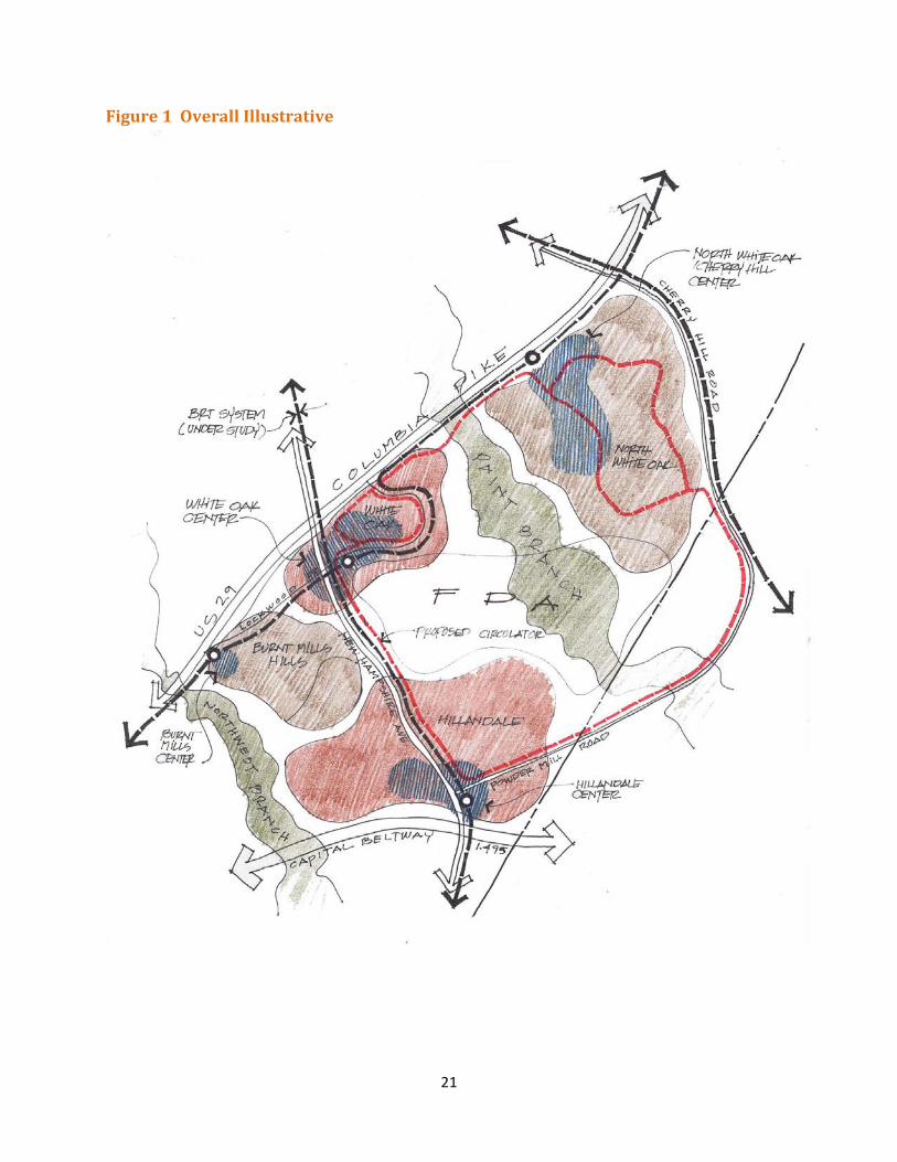
inclusive, allowing for a wide variety of possibilities that can respond to the market. The Plan recommends rezoning commercial areas to the Commercial-Residential (CR) Zones, which allow a broad range of commercial uses, including general offices, technology and biotechnology, research and development, hospitals, educational institutions, some manufacturing and production, as well as multi-family residential and supportive retail services to create a complete community. Land Use Supported by Transit The County is studying a comprehensive bus rapid transit system that would utilize portions of existing roadways for exclusive bus service. Improving transit service within existing corridors is intended to reduce congestion and reliance on automobiles while improving transportation capacity and meeting demands for existing and future land uses. The Planning Department is preparing a Countywide Transit Corridors Functional Master Plan that identifies the corridors and right-of-way requirements for a Bus Rapid Transit (BRT) system. Proposed BRT corridors in the WOSG Plan area include US 29, New Hampshire Avenue, and Randolph/Cherry Hill Road. This Plan’s goal is for future growth to be supported by a BRT system that will serve the local area while connecting it to major destinations and to the existing and proposed transit services in the region. A BRT system with proposed stations at the Plan’s centers could help spur reinvestment and redevelopment, as well as support new growth, by providing a more efficient transit alternative in an area that has been stymied due to a lack of road capacity and underserved by high quality transit. The urban design framework combines the BRT system currently under study with the locations of the existing commercial centers to promote development within areas centered on future transit nodes (see Figure 1). The US 29 BRT corridor extends from the Silver Spring Transit Center to Burtonsville. The New Hampshire Avenue corridor extends from the Colesville Park and Ride Lot to the Fort Totten Metrorail Station. This Plan recommends a transit station at the White Oak/FDA Center that could serve as a transfer hub between the BRT routes on US 29 and New Hampshire Avenue. Along New Hampshire Avenue, the Plan recommends BRT stations at FDA’s main entrance and at Hillandale (see Map 13 on page 61). The BRT corridor under consideration along Randolph Road and Cherry Hill Road would connect White Oak with Glenmont and White Flint/Rockville Pike. In addition, it is anticipated that enhanced local bus service, perhaps a circulator bus loop, would link the communities of White Oak to the BRT stations to better serve the entire area.
21
Figure 1 Overall Illustrative
22
Land Use-Transportation Balance Traditionally, master plans seek to balance the recommended land use densities (at build-out) and the transportation infrastructure needed to support the planned development. But traffic congestion in the eastern County, particularly on US 29, has been a long-standing problem and previous master plans have acknowledged the difficulty of achieving balance. The 1981 Master Plan stated that “…projected demand for roadway capacity in the planning area cannot be satisfied.” (page 158) Sixteen years later, the 1997 Fairland Master Plan confirmed that this statement was still true and stated “It will not be possible to add sufficient capacity through roadway improvements alone.” (page 87) The previous master plans for this area (the 1997 White Oak Master Plan and the 1997 Fairland Master Plan) determined that balance would be achieved if eight grade-separated interchanges were built on US 29. Four of the eight interchanges were constructed by the Maryland State Highway Administration. The other four interchanges have not been built and are not currently funded for construction, so the area is not considered to be in land use-transportation balance today, even though there has not been significant new private sector development. Like the previous Master Plans, this Plan does not achieve land use-transportation balance either, even with a proposed BRT network and construction of the remaining interchanges to support mixed land uses and higher densities. It is worth noting that the land use-transportation analysis is based on assumptions devised to test a future scenario. With regard to land use, the analysis assumes that many properties, even those with existing buildings, will redevelop to the highest possible density allowed by zoning. This development assumption is made in order to determine a “worst case” scenario for traffic modeling purposes. Likewise, the provision of most of the transportation infrastructure – transit, roads, interchanges – needed to support the land use scenario is assumed as well, even if it is not funded or programmed for construction. Both the potential build-out of the hypothetical land use scenario and the implementation of the recommended transportation network are long term endeavors that may take 20 years or longer. Properties without existing improvements (Site 2, Percontee, and WAH) are more likely to development sooner because it is easier to develop vacant land than redevelop land that has structures, businesses, tenants, parking, and is producing income. Most of the White Oak area is developed, but for traffic modeling purposes, it is assumed that the undeveloped properties, as well as places like the White Oak and Hillandale shopping centers, will redevelop to fairly high densities. The traffic model also assumed the ultimate build-out of the FDA campus. The modeling does not distinguish between the development potential of more probable near term sites versus ones that are less likely to redevelop. With these assumptions, the amount of potential development in the traffic model is relatively high. Yet, in reality, maximizing density rarely, if ever, occurs and certainly not all at once. Market demand and absorption rates are limiting factors as are development regulations, including parking, environmental, and open space requirements, setbacks, height, and use restrictions.
23
Traditional strategies to achieve land use-transportation balance – such as decreasing densities or building new roads – would not allow this Plan to address its specific challenges and constraints. If the land use densities allowed by the Plan were reduced, it could be more difficult to support the high-quality transit service needed to achieve the Plan’s vision or spur the kind of reinvestment many community members seek and that the County has already established as an important public policy for its Site 2 partnership. External traffic from Howard and Prince George’s Counties, which Montgomery County does not control, is a major contributor to traffic congestion in this area. Even if Montgomery County limited development, as it has done in the eastern County in the past, regional and local traffic will continue to congest the highway network. Options to increase traffic capacity by enhancing the local road network are limited within this Plan area due to existing development patterns, land ownership, and environmental resources. If this Plan’s vision is to be achieved, stakeholders, including the County, must acknowledge and accept that there is an imbalance between the potential land use and the transportation infrastructure necessary to support full development. This Plan recommends proceeding with a revised planning framework that manages future growth through both Master Plan staging and the regulatory review process. The regulatory “checks and balances” require new development to meet adequate public facilities tests, including Transportation Policy Area Review, Local Area Transportation Review, and school capacity, all regulated by the County’s Subdivision Staging Policy, which is reviewed and revised regularly. In addition, this Plan’s recommended staging will limit and monitor the amount of development that is allowed to proceed prior to the provision of certain infrastructure improvements. In other words, while this Plan is not technically in balance, the staging plan and existing regulatory adequacy tests provide a reasonable approach to match future growth with needed public facilities.

24
25
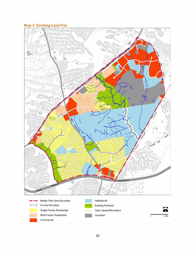
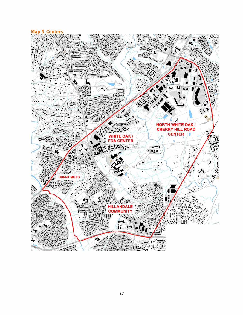
LAND USE AND ZONING The White Oak area developed in a quintessentially suburban pattern, where land uses -- residential, retail, and employment -- are separated rather than integrated and mobility is highly reliant on the automobile. Located along major roads and intersections, the existing commercial centers at White Oak, Hillandale, and Burnt Mills provide neighborhood retail services in grocery store-anchored shopping centers primarily serving the surrounding residential communities (see Maps 4 and 5). The White Oak and Hillandale shopping centers and adjacent commercial uses along New Hampshire Avenue have remained essentially unchanged for several decades, although the tenant mix has shifted through the years. The North White Oak/Cherry Hill Road Center includes offices, service industry uses (automotive, contractors), public facilities, and some retail. This area also includes the 300-acre Percontee/Site 2 parcels that are proposed for significant new development.
This Plan envisions three major activity centers: White Oak/FDA Center
FDA Headquarters at the Federal Research Center at White Oak
White Oak Shopping Center
Commercial properties at Lockwood Drive and New Hampshire Avenue
Residential communities Hillandale Community
Hillandale Shopping Center and Elton Road commercial properties
New Hampshire Avenue commercial properties
National Labor College site
Hillandale residential community North White Oak/Cherry Hill Road Center
Percontee and Site 2 properties
Potential Washington Adventist Hospital site
Montgomery Industrial Park
North White Oak/Westech Business Park
Paint Branch residential community Reshaping and redeveloping these centers into sustainable, complete communities is both challenging and necessary. The Plan seeks to change and transform these areas over time, with the support of a future BRT system. Mixed-use developments encourage the combination of commercial, residential, and retail uses within compact, walkable centers that bring employment, housing, and shopping opportunities together. This Plan’s zoning and infrastructure recommendations strive to encourage the private sector to redesign, redevelop, and reinvest in older centers.
26
Map 4 Existing Land Use
27
Map 5 Centers
28
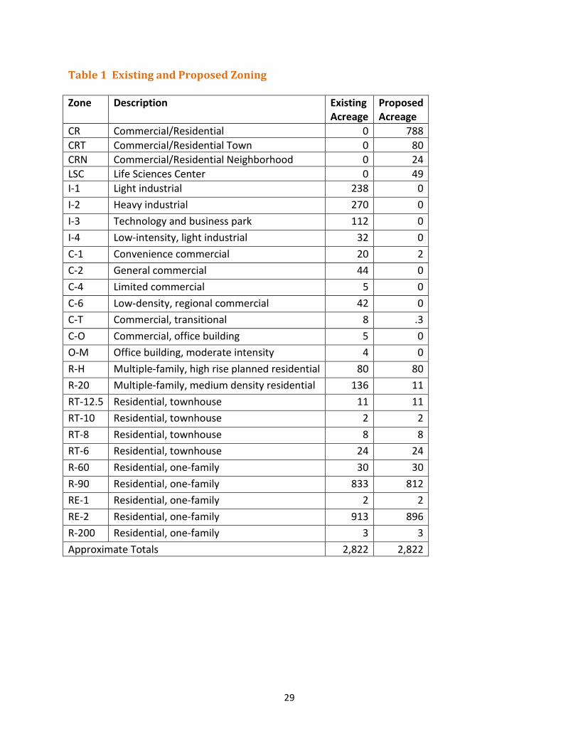
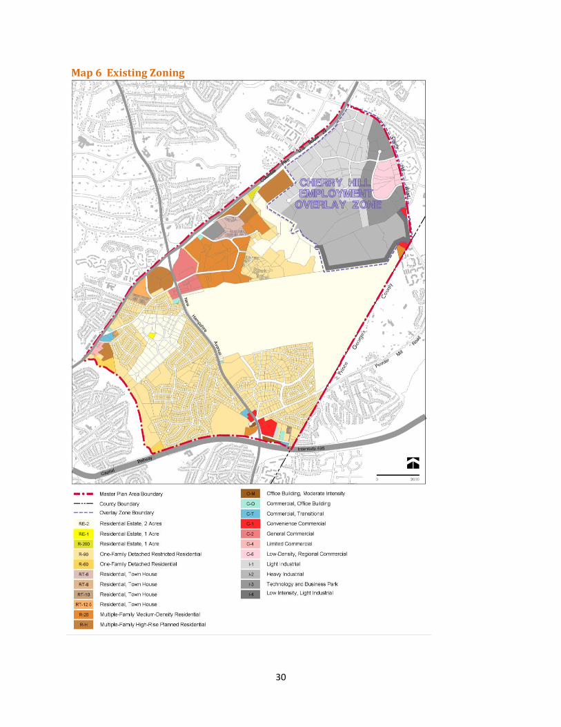
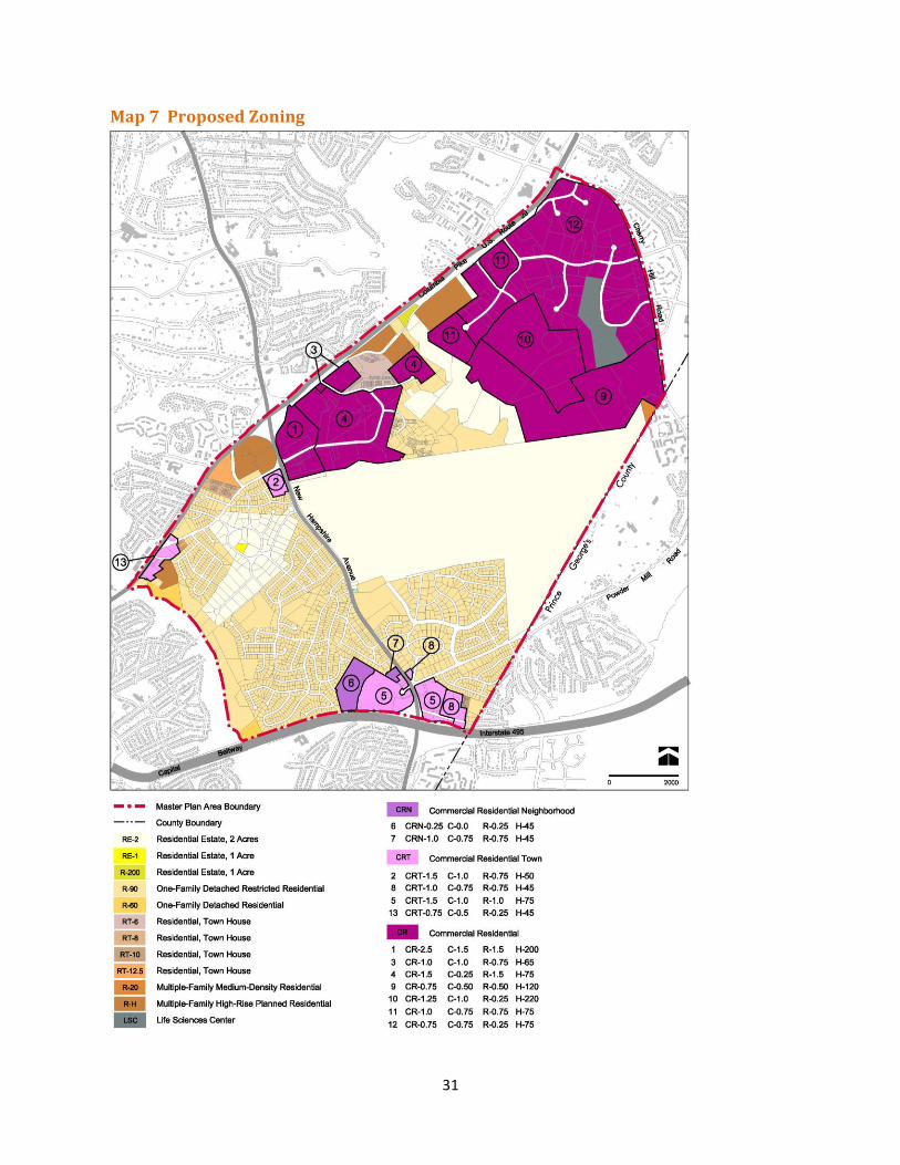
Proposed Development and Zoning Overview The Plan’s proposed land use and zoning framework is based on a development scenario (that was modeled and tested for traffic implications) involving specific alternatives provided by commercial property owners as well as input from the residential communities. Existing development in the Plan area includes 7,118 dwelling units and approximately 11 million square feet of commercial uses. The traffic model tested a total land use amount - existing and projected development – of approximately 25 million square feet of commercial development and 15,000 dwelling units (see Table 5 on page 94), supported by a transit system and additional road infrastructure. The Plan recommends rezoning most commercial properties to the Commercial/Residential (CR) Zone or the Commercial/Residential Town (CRT) Zone (see Table 1 and Maps 6 and 7). The CR Zones allow a range of uses and require the designation of four elements: total allowed floor area ratio (FAR), maximum commercial/non-residential (C) floor area ratio, maximum residential (R) floor area ratio, and maximum building height (H). The recommended CR Zones are designed to encourage a mix of uses in the Plan’s centers, where BRT routes and stations are also planned. The Plan proposes CR zones at sufficient densities to provide incentives for private reinvestment, promote transit, and provide needed public amenities in redeveloping areas, including open space, recreation, day care centers, better building design, and affordable housing. For commercial properties unlikely to redevelop in the near term, the Plan proposes CR zoning designations that are comparable to the existing zoning. The Plan also seeks to preserve and protect the character of the single-family neighborhoods by confirming existing uses and zoning. Properties zoned as single-family dwellings (in the R-90, RE-1, and RE-2 zones) and properties with townhouse zoning (RT-6, RT-8, RT-10, RT-12.5) will not be rezoned. Some properties that are currently in the medium-density multi-family zone (R-20) are recommended to be rezoned to a CR Zone that increases potential density but continues to emphasize housing as the primary use. For properties currently zoned R-H, all of which are developed, the Plan recommends retaining this zone.
29
Table 1 Existing and Proposed Zoning
Zone Description Existing Acreage
Proposed Acreage
CR Commercial/Residential 0 788
CRT Commercial/Residential Town 0 80
CRN Commercial/Residential Neighborhood 0 24
LSC Life Sciences Center 0 49
I-1 Light industrial 238 0
I-2 Heavy industrial 270 0
I-3 Technology and business park 112 0
I-4 Low-intensity, light industrial 32 0
C-1 Convenience commercial 20 2
C-2 General commercial 44 0
C-4 Limited commercial 5 0
C-6 Low-density, regional commercial 42 0
C-T Commercial, transitional 8 .3
C-O Commercial, office building 5 0
O-M Office building, moderate intensity 4 0
R-H Multiple-family, high rise planned residential 80 80
R-20 Multiple-family, medium density residential 136 11
RT-12.5 Residential, townhouse 11 11
RT-10 Residential, townhouse 2 2
RT-8 Residential, townhouse 8 8
RT-6 Residential, townhouse 24 24
R-60 Residential, one-family 30 30
R-90 Residential, one-family 833 812
RE-1 Residential, one-family 2 2
RE-2 Residential, one-family 913 896
R-200 Residential, one-family 3 3
Approximate Totals 2,822 2,822
30
Map 6 Existing Zoning
31
Map 7 Proposed Zoning
32
White Oak/FDA Center The White Oak/FDA Center is located at New Hampshire Avenue and Lockwood Drive and includes the Food and Drug Administration (FDA) campus. Adjacent to the FDA campus are retail uses at the White Oak Shopping Center (anchored by Giant and Sears), several office buildings, ancillary retail, and two self-storage facilities. Along Lockwood Drive, April Lane, and Stewart Lane, there is a substantial amount of housing, including high-rise apartments, garden apartments, and townhouses. The White Oak Community Recreation Center is in the midst of this dense residential area.
The Federal Research Center and the Food and Drug Administration The most significant new development activity in this area in the past decade has been the consolidation of the FDA headquarters at the Federal Research Center (FRC). The 662-acre FRC was the site of the Naval Surface Warfare Center, of which 622 acres are in Montgomery County and 40 acres are in Prince George’s County. The U.S. Navy acquired the property in 1944 when World War II prompted an increased demand for weapons research, development, and testing beyond the capacity of the Washington Navy Yard in southeast Washington, D.C. In 1969, a portion of the Naval Ordnance Laboratory site along the County line was transferred to the Department of the Army for construction of the Harry Diamond Laboratories, now the Army Adelphi Laboratory Center.
In 1995, the Naval Surface Warfare Center was closed and the site was transferred to the General Services Administration. In 1996, the site was renamed the Federal Research Center at White Oak and 130 acres of the western portion of the FRC was mandated for consolidation of the regionally dispersed facilities of the FDA into a secured campus headquarters with state-of-the-art laboratories, offices, support facilities, and amenities. The main entrance of the FDA campus, at 10903 New Hampshire Avenue, retains the stately setting of the previous use with a large open space (former golf course), linear drive, and renovation and integration of the original Naval Ordnance Administration Building into the new FDA headquarters. The FDA site, which has been under construction since 2001, currently has 5,000 employees and 4.5 million square feet. Upon completion in 2014 (contingent on Congressional appropriations), nearly 9,000 employees will be working in nearly six million square feet.
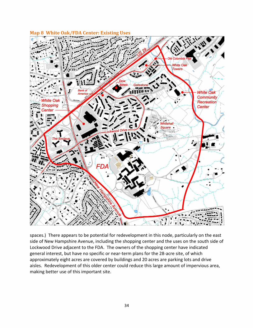
Commercial Properties The total amount of existing commercial development in this node (excluding FDA) is approximately 1,000,000 square feet, of which nearly half is the White Oak Shopping Center (477,155). Built in the early 1960s, the 28-acre shopping center is in single ownership and is the largest commercial property in this node (see Map 8). On the south side of Lockwood Drive, on the same side of New Hampshire as the shopping center, is one office building (White Oak Professional Building, built in 1965) and a series of ancillary retail uses (gas station, 7-Eleven, automotive shop, health club, and two self-storage facilities). These uses are on 13 parcels with nine property owners and total about 13 acres. The shopping center and Lockwood Drive uses are currently zoned C-2. On the west side of New Hampshire Avenue, south of Lockwood Drive are townhouse-style offices as well as an office building, an Office Depot store, and a gas station in the C-2 and C-O Zones.
33
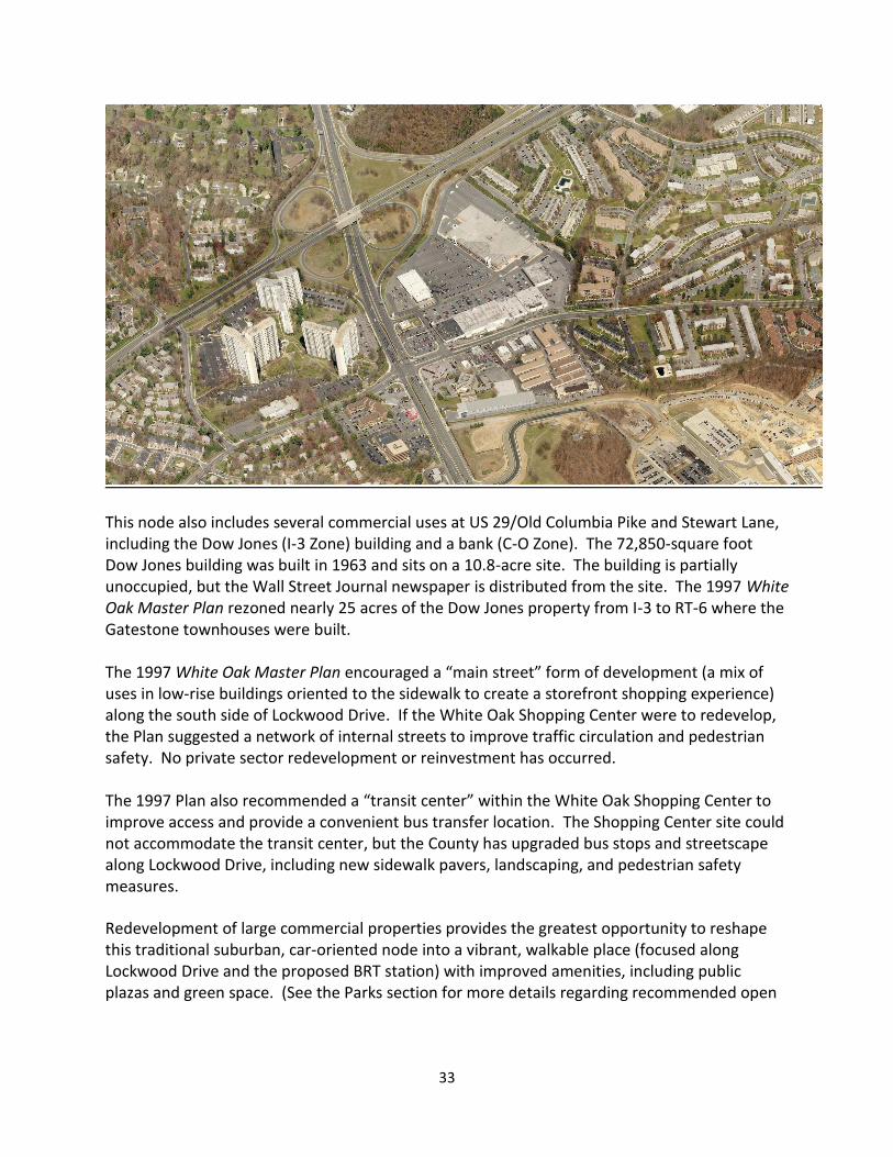
This node also includes several commercial uses at US 29/Old Columbia Pike and Stewart Lane, including the Dow Jones (I-3 Zone) building and a bank (C-O Zone). The 72,850-square foot Dow Jones building was built in 1963 and sits on a 10.8-acre site. The building is partially unoccupied, but the Wall Street Journal newspaper is distributed from the site. The 1997 White Oak Master Plan rezoned nearly 25 acres of the Dow Jones property from I-3 to RT-6 where the Gatestone townhouses were built. The 1997 White Oak Master Plan encouraged a “main street” form of development (a mix of uses in low-rise buildings oriented to the sidewalk to create a storefront shopping experience) along the south side of Lockwood Drive. If the White Oak Shopping Center were to redevelop, the Plan suggested a network of internal streets to improve traffic circulation and pedestrian safety. No private sector redevelopment or reinvestment has occurred. The 1997 Plan also recommended a “transit center” within the White Oak Shopping Center to improve access and provide a convenient bus transfer location. The Shopping Center site could not accommodate the transit center, but the County has upgraded bus stops and streetscape along Lockwood Drive, including new sidewalk pavers, landscaping, and pedestrian safety measures. Redevelopment of large commercial properties provides the greatest opportunity to reshape this traditional suburban, car-oriented node into a vibrant, walkable place (focused along Lockwood Drive and the proposed BRT station) with improved amenities, including public plazas and green space. (See the Parks section for more details regarding recommended open
34
Map 8 White Oak/FDA Center: Existing Uses
spaces.) There appears to be potential for redevelopment in this node, particularly on the east side of New Hampshire Avenue, including the shopping center and the uses on the south side of Lockwood Drive adjacent to the FDA. The owners of the shopping center have indicated general interest, but have no specific or near-term plans for the 28-acre site, of which approximately eight acres are covered by buildings and 20 acres are parking lots and drive aisles. Redevelopment of this older center could reduce this large amount of impervious area, making better use of this important site.
35
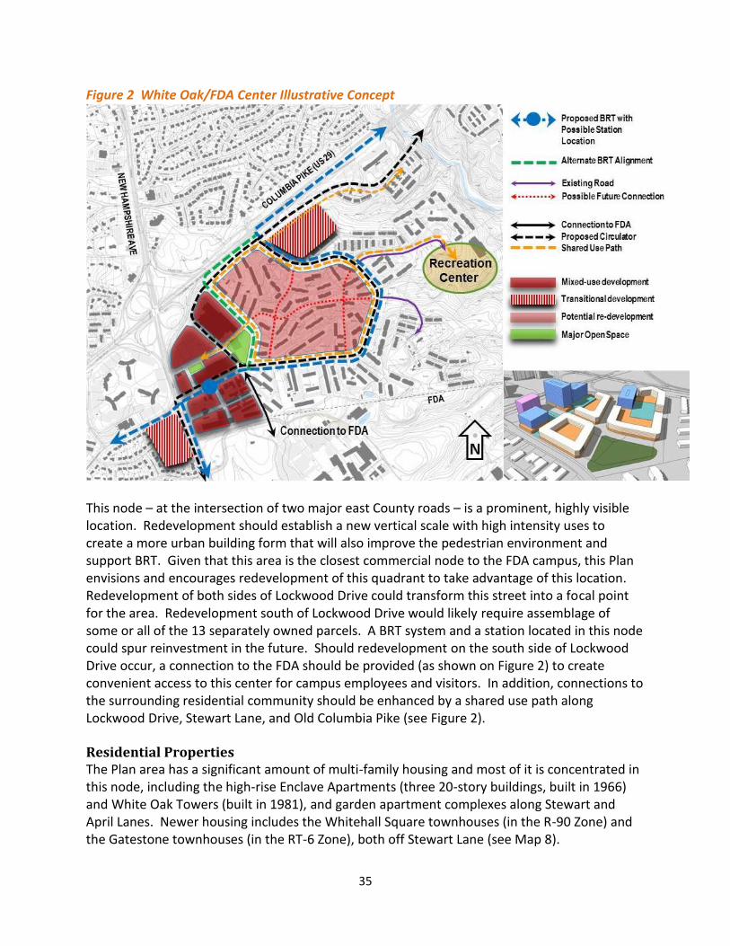
Figure 2 White Oak/FDA Center Illustrative Concept
This node – at the intersection of two major east County roads – is a prominent, highly visible location. Redevelopment should establish a new vertical scale with high intensity uses to create a more urban building form that will also improve the pedestrian environment and support BRT. Given that this area is the closest commercial node to the FDA campus, this Plan envisions and encourages redevelopment of this quadrant to take advantage of this location. Redevelopment of both sides of Lockwood Drive could transform this street into a focal point for the area. Redevelopment south of Lockwood Drive would likely require assemblage of some or all of the 13 separately owned parcels. A BRT system and a station located in this node could spur reinvestment in the future. Should redevelopment on the south side of Lockwood Drive occur, a connection to the FDA should be provided (as shown on Figure 2) to create convenient access to this center for campus employees and visitors. In addition, connections to the surrounding residential community should be enhanced by a shared use path along Lockwood Drive, Stewart Lane, and Old Columbia Pike (see Figure 2). Residential Properties The Plan area has a significant amount of multi-family housing and most of it is concentrated in this node, including the high-rise Enclave Apartments (three 20-story buildings, built in 1966) and White Oak Towers (built in 1981), and garden apartment complexes along Stewart and April Lanes. Newer housing includes the Whitehall Square townhouses (in the R-90 Zone) and the Gatestone townhouses (in the RT-6 Zone), both off Stewart Lane (see Map 8).
36
Of the 4,500 units in the area, 4,240 are multi-family units and 260 are townhouses. There are 2,709 garden apartment units in the R-20 Zone near the White Oak Shopping Center along Lockwood Drive, Stewart Lane, and April Lane. The Enclave and White Oak Towers buildings are in the R-H Zone and total 1,532 units.
Over 90 percent of the multi-family units in the area are at least 25 years old. Many apartment buildings were constructed in the 1960s, with structures that are now over 45 years old. Much of this housing is considered market affordable, although units are not part of a formal housing subsidy program. In areas with market affordable housing, rents are generally lower than comparable units in other locations in the County, particularly when compared to new construction. In addition to location, units may be market affordable due to demand, neighborhood characteristics, age, physical conditions, and lack of amenities. The County’s primary affordable housing program is referred to as Moderately Priced Dwelling Units (MPDUs). The White Oak area does not have any MPDUs because its apartments were built before the MPDU requirements were applied to rental properties. Based on the housing analysis prepared for this Plan, 77 percent of the units in the nine apartment complexes along April-Stewart Lanes are market affordable (see Appendix C).
Several owners of apartment buildings in this area have suggested that some buildings may need extensive renovations or may be reaching the end of their maximum life expectancy, with redevelopment becoming a possibility. Should redevelopment occur, connections in this area should be improved, as shown on Figure 2.
One of the critical issues in this area is whether increasing density and/or changing the zoning from R-20 (a single-use, medium density multi-family zone) to a mixed-use/CR zone poses a risk that potential redevelopment will result in rent increases that reduce or eliminate the number of units that are currently market affordable and will result in displacement. The Plan’s challenge for this area is to protect its affordability while also providing incentives for property owners to reinvest in these older buildings. To achieve this, the Plan recommends higher density than what is there today while encouraging more MPDUs than the required minimum. If there is redevelopment, owners of the existing garden apartments should, where possible, utilize strategies that achieve an orderly, phased replacement of older buildings with upgraded multi-family communities while minimizing, if not eliminating, dislocation of current residents. This Plan strongly encourages owners and developers to create opportunities and incentives that allow existing tenants to remain and reside in new units, once constructed.
Zoning Recommendations Rezone 41 acres of commercial properties on the east side of New Hampshire Avenue,
including the 28-acre White Oak Shopping Center and the 13 acres on the south side of Lockwood Drive, from C-2 to CR-2.5, C-1.5, R-1.5, H-200 (see number 1 on Map 7 on page 31) to allow mixed uses. This CR Zone requires a mix of commercial and residential uses to achieve the full density of 2.5 FAR. Given its location adjacent to an interchange and existing high-rise apartments, this area would be appropriate for mid-to high-rise buildings. Higher buildings create smaller building footprints, providing more land for open space.
37
Rezone approximately 7 acres of commercial properties west of New Hampshire and south of Lockwood Drive from C-2 and C-O to CRT-1.5, C-1.0, R-0.75, H-50 (see number 2 on Map 7). The overall density and height of this CRT designation is comparable to what is allowed under current zoning, but allows a mix of commercial and residential uses should the site redevelop.
Rezone approximately 12 acres of commercial property, including the Dow Jones and Bank of America sites, from I-3 and C-O to CR-1.0, C-1.0, R-0.75, H-65 (see number 3 on Map 7). Given the location of these sites along US 29 and the current uses, redevelopment of these properties would likely be commercial rather than residential.
Rezone properties in the R-20 Zone to CR-1.5, C-0.25, R-1.5, H-75 (see number 4 on Map 7) to emphasize residential as the primary use, with the possibility of some supportive retail within the area.
Retain the existing R-H Zone for the high-rise Enclave and White Oak Towers buildings.
Retain the existing RT-6 and R-90 zones at the Gatestone and Whitehall Square developments.
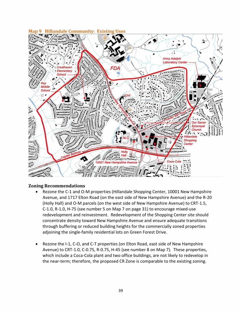
Hillandale Community The Hillandale community, located north of I-495 along New Hampshire Avenue, includes established single-family neighborhoods, commercial uses, and the National Labor College site (see Map 9). Our Savior Episcopal Church is a prominent local landmark at New Hampshire Avenue and Powder Mill Road. The Hillandale Shopping Center, built in the early 1960s, is anchored by a Safeway, a Value Village thrift store, and several restaurants. There are four office buildings along Elton Road, as well as a Coca-Cola distribution facility. Ancillary retail uses and an office building are on New Hampshire Avenue north of Powder Mill Road. Much of the commercial area is in single ownership, including the shopping center and the three office buildings on the south side of Elton Drive adjacent to I-495. The office building at 10001 New Hampshire Avenue was completed in 2010 and is currently leased by FDA. The other four office buildings in Hillandale were built between 1977-1986. The U.S. Army Adelphi Laboratory Center, with its main entrance at 2800 Powder Mill Road, is adjacent to Hillandale and the FRC property.
The 46-acre site of the National Labor College (NLC) is located on the west side of New Hampshire Avenue at Powder Mill Road. The Labor College has been at this site for 41 years, succeeding Xaverian College, which operated there from 1931 to 1971. The property is currently for sale. Holly Hall, a 96-unit senior residence owned by the Housing Opportunities Commission, is located adjacent to the Labor College. Holly Hall is in the R-20 Zone and the Labor College is in the R-90 Zone (with a special exception for a private educational institution).
38
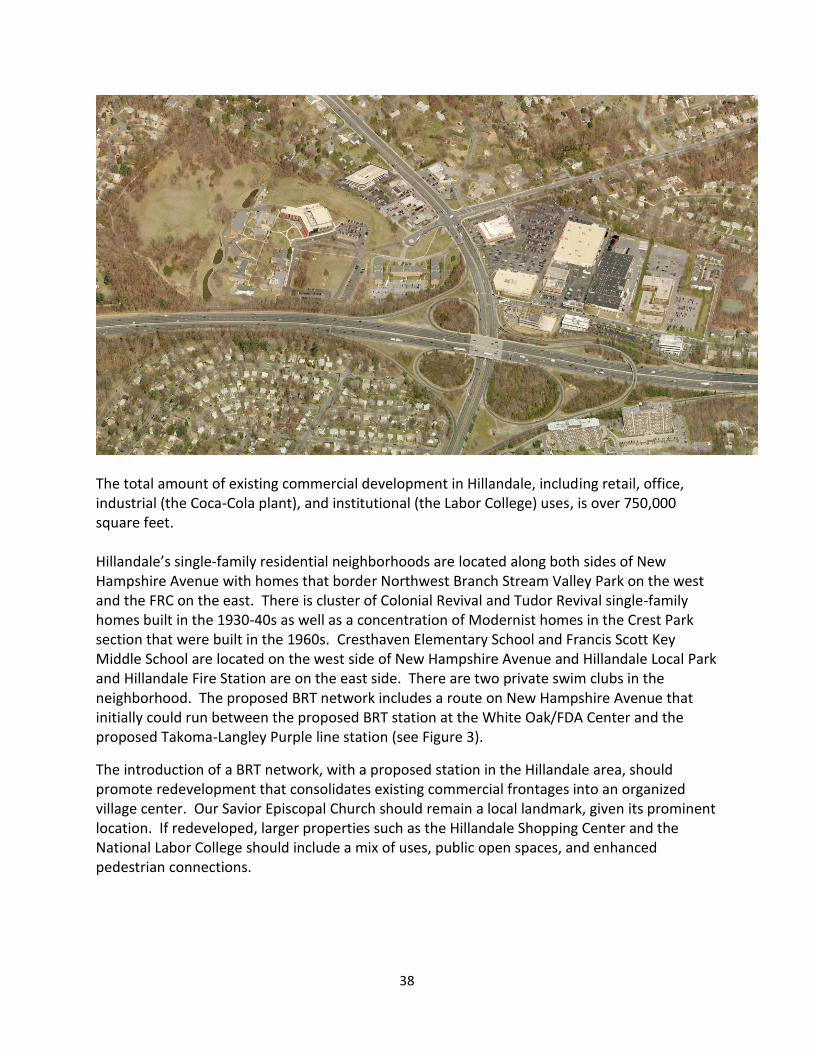
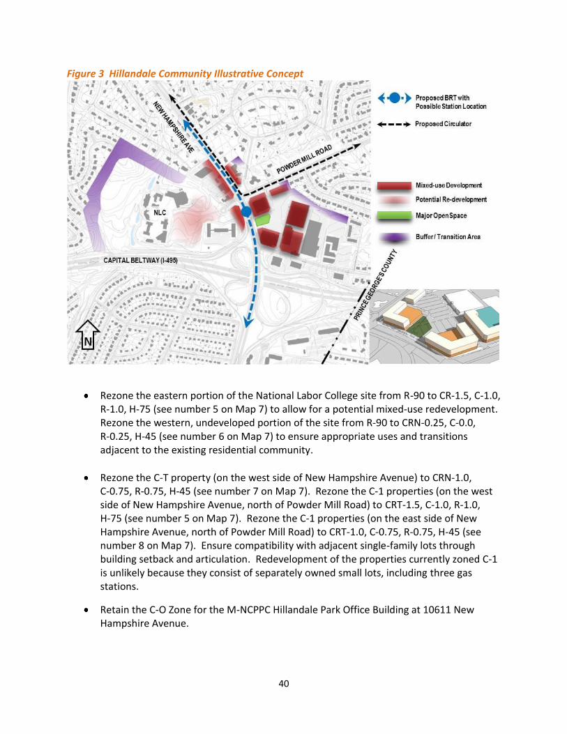
The total amount of existing commercial development in Hillandale, including retail, office, industrial (the Coca-Cola plant), and institutional (the Labor College) uses, is over 750,000 square feet. Hillandale’s single-family residential neighborhoods are located along both sides of New Hampshire Avenue with homes that border Northwest Branch Stream Valley Park on the west and the FRC on the east. There is cluster of Colonial Revival and Tudor Revival single-family homes built in the 1930-40s as well as a concentration of Modernist homes in the Crest Park section that were built in the 1960s. Cresthaven Elementary School and Francis Scott Key Middle School are located on the west side of New Hampshire Avenue and Hillandale Local Park and Hillandale Fire Station are on the east side. There are two private swim clubs in the neighborhood. The proposed BRT network includes a route on New Hampshire Avenue that initially could run between the proposed BRT station at the White Oak/FDA Center and the proposed Takoma-Langley Purple line station (see Figure 3).
The introduction of a BRT network, with a proposed station in the Hillandale area, should promote redevelopment that consolidates existing commercial frontages into an organized village center. Our Savior Episcopal Church should remain a local landmark, given its prominent location. If redeveloped, larger properties such as the Hillandale Shopping Center and the National Labor College should include a mix of uses, public open spaces, and enhanced pedestrian connections.
39
Map 9 Hillandale Community: Existing Uses
Zoning Recommendations
Rezone the C-1 and O-M properties (Hillandale Shopping Center, 10001 New Hampshire Avenue, and 1717 Elton Road (on the east side of New Hampshire Avenue) and the R-20 (Holly Hall) and O-M parcels (on the west side of New Hampshire Avenue) to CRT-1.5, C-1.0, R-1.0, H-75 (see number 5 on Map 7 on page 31) to encourage mixed-use redevelopment and reinvestment. Redevelopment of the Shopping Center site should concentrate density toward New Hampshire Avenue and ensure adequate transitions through buffering or reduced building heights for the commercially zoned properties adjoining the single-family residential lots on Green Forest Drive.
Rezone the I-1, C-O, and C-T properties (on Elton Road, east side of New Hampshire Avenue) to CRT-1.0, C-0.75, R-0.75, H-45 (see number 8 on Map 7). These properties, which include a Coca-Cola plant and two office buildings, are not likely to redevelop in the near-term; therefore, the proposed CR Zone is comparable to the existing zoning.
40
Figure 3 Hillandale Community Illustrative Concept
Rezone the eastern portion of the National Labor College site from R-90 to CR-1.5, C-1.0, R-1.0, H-75 (see number 5 on Map 7) to allow for a potential mixed-use redevelopment. Rezone the western, undeveloped portion of the site from R-90 to CRN-0.25, C-0.0, R-0.25, H-45 (see number 6 on Map 7) to ensure appropriate uses and transitions adjacent to the existing residential community.
Rezone the C-T property (on the west side of New Hampshire Avenue) to CRN-1.0, C-0.75, R-0.75, H-45 (see number 7 on Map 7). Rezone the C-1 properties (on the west side of New Hampshire Avenue, north of Powder Mill Road) to CRT-1.5, C-1.0, R-1.0, H-75 (see number 5 on Map 7). Rezone the C-1 properties (on the east side of New Hampshire Avenue, north of Powder Mill Road) to CRT-1.0, C-0.75, R-0.75, H-45 (see number 8 on Map 7). Ensure compatibility with adjacent single-family lots through building setback and articulation. Redevelopment of the properties currently zoned C-1 is unlikely because they consist of separately owned small lots, including three gas stations.
Retain the C-O Zone for the M-NCPPC Hillandale Park Office Building at 10611 New Hampshire Avenue.
41
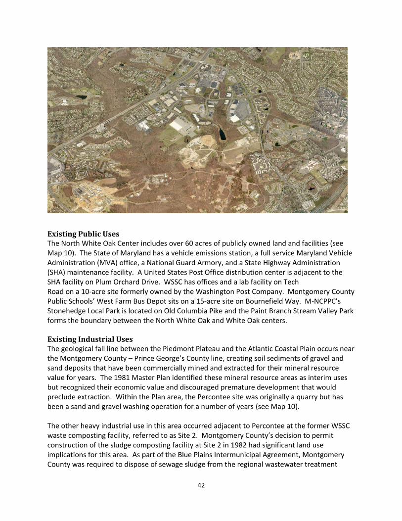
North White Oak/Cherry Hill Road Center This 800-acre area is bounded by US 29, Cherry Hill Road, the FRC property line, and the Paint Branch Stream Valley Park. The 1997 Fairland Master Plan referred to this area as the US 29/Cherry Hill Road Employment Area and identified four sub areas — Montgomery Industrial Park, West Farm Technology Park, Site 2, and the Percontee sand and gravel facility. It considered the Paint Branch residential community separately. This Plan refers to this area as the North White Oak/Cherry Hill Road Center and considers the Paint Branch residential community inclusively. The 1997 Plan’s recommendation to acquire several parcels adjacent to the residential area for a park was implemented to create Stonehedge Local Park, located on Old Columbia Pike. This area has been home to light industrial and service uses, back offices, public sector facilities, and heavy industrial (see Map 10). Montgomery Industrial Park is the older section (developed between the late 1960s to the early 1980s) with buildings along Tech Road and Industrial Parkway. A six-acre site with a building formerly occupied by the American Postal Workers Union (APWU) at Old Columbia Pike and Industrial Parkway is vacant. West Farm is the newer section (mostly developed in the late 1980s) with office buildings along Broadbirch Drive and Bournefield Way. This area includes a Home Depot and DarCars auto sales and repair center. More recent development includes the restaurant-oriented Westech Village Corner (at Tech Road and Broadbirch Drive), an adjacent Hilton Garden Inn hotel (on Broadbirch Drive), and a Marriott Residence Inn hotel (at Cherry Hill Road and Plum Orchard Drive). Total existing development in this area, including office, light industrial, institutional, and retail is 3,375,776 square feet. In 2006, Adventist HealthCare (AHC) located its world headquarters on a 21-acre site at the southwest corner of US 29 and Randolph Road (outside the Plan area). With 600 employees, it is one of the area’s largest employers. AHC also owns 21 acres adjacent to the headquarters site, as well as the Adventist Book Store located in the Orchard Center and several area churches. In addition, AHC assembled five parcels totaling 48 acres along Plum Orchard Drive, where it plans to relocate Washington Adventist Hospital from Takoma Park and build a new hospital and several medical office buildings. AHC received development approval from the Planning Board in 2008. A certificate of need is pending approval with the State of Maryland, with a decision expected in 2014.
Several large parcels in Montgomery Industrial Park have been acquired by a local development company, including 13 acres in the block bounded by Old Columbia Pike, Industrial Parkway, and Tech Road and a 25-acre parcel at the end of Tech Road. Redevelopment of the 13-acre parcel could include the 6-acre vacant APWU site (under contract by the same developers). This is a highly visible location along US 29, as well as a gateway to this node between two primary roads. Redevelopment of this entire block, including the former APWU building, would be a significant improvement and would complement the Westech Village Corner project, across Tech Road from this site.
42
Existing Public Uses The North White Oak Center includes over 60 acres of publicly owned land and facilities (see Map 10). The State of Maryland has a vehicle emissions station, a full service Maryland Vehicle Administration (MVA) office, a National Guard Armory, and a State Highway Administration (SHA) maintenance facility. A United States Post Office distribution center is adjacent to the SHA facility on Plum Orchard Drive. WSSC has offices and a lab facility on Tech Road on a 10-acre site formerly owned by the Washington Post Company. Montgomery County Public Schools’ West Farm Bus Depot sits on a 15-acre site on Bournefield Way. M-NCPPC’s Stonehedge Local Park is located on Old Columbia Pike and the Paint Branch Stream Valley Park forms the boundary between the North White Oak and White Oak centers. Existing Industrial Uses The geological fall line between the Piedmont Plateau and the Atlantic Coastal Plain occurs near the Montgomery County – Prince George’s County line, creating soil sediments of gravel and sand deposits that have been commercially mined and extracted for their mineral resource value for years. The 1981 Master Plan identified these mineral resource areas as interim uses but recognized their economic value and discouraged premature development that would preclude extraction. Within the Plan area, the Percontee site was originally a quarry but has been a sand and gravel washing operation for a number of years (see Map 10). The other heavy industrial use in this area occurred adjacent to Percontee at the former WSSC waste composting facility, referred to as Site 2. Montgomery County’s decision to permit construction of the sludge composting facility at Site 2 in 1982 had significant land use implications for this area. As part of the Blue Plains Intermunicipal Agreement, Montgomery County was required to dispose of sewage sludge from the regional wastewater treatment
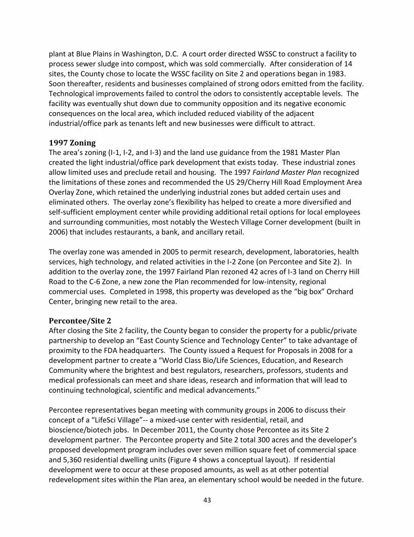
43
plant at Blue Plains in Washington, D.C. A court order directed WSSC to construct a facility to process sewer sludge into compost, which was sold commercially. After consideration of 14 sites, the County chose to locate the WSSC facility on Site 2 and operations began in 1983. Soon thereafter, residents and businesses complained of strong odors emitted from the facility. Technological improvements failed to control the odors to consistently acceptable levels. The facility was eventually shut down due to community opposition and its negative economic consequences on the local area, which included reduced viability of the adjacent industrial/office park as tenants left and new businesses were difficult to attract. 1997 Zoning The area’s zoning (I-1, I-2, and I-3) and the land use guidance from the 1981 Master Plan created the light industrial/office park development that exists today. These industrial zones allow limited uses and preclude retail and housing. The 1997 Fairland Master Plan recognized the limitations of these zones and recommended the US 29/Cherry Hill Road Employment Area Overlay Zone, which retained the underlying industrial zones but added certain uses and eliminated others. The overlay zone’s flexibility has helped to create a more diversified and self-sufficient employment center while providing additional retail options for local employees and surrounding communities, most notably the Westech Village Corner development (built in 2006) that includes restaurants, a bank, and ancillary retail. The overlay zone was amended in 2005 to permit research, development, laboratories, health services, high technology, and related activities in the I-2 Zone (on Percontee and Site 2). In addition to the overlay zone, the 1997 Fairland Plan rezoned 42 acres of I-3 land on Cherry Hill Road to the C-6 Zone, a new zone the Plan recommended for low-intensity, regional commercial uses. Completed in 1998, this property was developed as the “big box” Orchard Center, bringing new retail to the area. Percontee/Site 2 After closing the Site 2 facility, the County began to consider the property for a public/private partnership to develop an “East County Science and Technology Center” to take advantage of proximity to the FDA headquarters. The County issued a Request for Proposals in 2008 for a development partner to create a “World Class Bio/Life Sciences, Education, and Research Community where the brightest and best regulators, researchers, professors, students and medical professionals can meet and share ideas, research and information that will lead to continuing technological, scientific and medical advancements.” Percontee representatives began meeting with community groups in 2006 to discuss their concept of a “LifeSci Village”-- a mixed-use center with residential, retail, and bioscience/biotech jobs. In December 2011, the County chose Percontee as its Site 2 development partner. The Percontee property and Site 2 total 300 acres and the developer’s proposed development program includes over seven million square feet of commercial space and 5,360 residential dwelling units (Figure 4 shows a conceptual layout). If residential development were to occur at these proposed amounts, as well as at other potential redevelopment sites within the Plan area, an elementary school would be needed in the future.
44
Map 10 North White Oak/Cherry Hill Road Center: Existing Uses
45
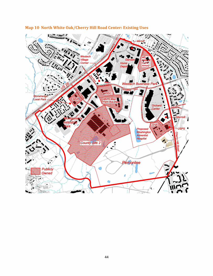
Figure 4 North White Oak/Cherry Hill Road Illustrative Concept
The Plan recommends that an adequate and appropriate site for an elementary school be dedicated on the Percontee property as part of the redevelopment of these two sites. This large development would also need to provide ample parks and open space amenities, including civic greens, a local park, and an integrated trail and bikeway system (see Parks section for more details). Development of this site could also be enhanced by orienting buildings along a perimeter road (with a shared use path) adjacent to and overlooking Paint Branch Stream Valley Park, integrating the natural and built environments and creating a scenic route for driving, walking, and biking (see Figure 4). Mobility The Plan envisions the North White Oak/Cherry Hill Road Center as a focal point of the BRT network serving the east County. Two of the three corridors under study in the Plan area (US 29 and Randolph Road) could potentially serve this area. Two additional BRT corridors, largely in Prince George’s County – one serving Konterra/Muirkirk MARC via Powder Mill Road and the other serving the Greenbelt Metrorail Station - are also envisioned as part of an eventual Countywide network. One or more internal circulator bus routes that connect this center with the other areas – White Oak/FDA, Hillandale, and Burnt Mills -- could complement these BRT corridors (see “proposed circulator” on Figure 4).
46
The Plan proposes that the Old Columbia Road bridge over the Paint Branch Stream Valley Park be rebuilt and opened to vehicular traffic. This connection would improve circulation between the centers, provide a direct route for a circulator bus to serve the BRT stations, and provide an alternative to US 29 for local traffic. The large scale, mixed-used development proposed for Site 2 and Percontee will transform these industrial sites. The circulation network should include extending Industrial Parkway through Site 2 and connecting it with FDA Boulevard to form a “main street” through this area. The development will include a series of smaller, interior streets as well as amenities and a network of open spaces. Public access to the Paint Branch Stream Valley Park and opportunities for outdoor recreation along its edge should be provided. To complement this new development, industrial properties to the north could, over the long term, introduce mixed uses and improve key properties to create adequate gateways to the area and enhance vehicular and pedestrian connections, both internally and with adjacent communities. This node includes several cul-de-sacs. When redevelopment occurs, the Plan recommends that these dead-end streets be extended and connected to improve circulation. Other opportunities to improve connectivity should be considered as this area redevelops (see possible future connections on Figure 4 and Map 12). Zoning Recommendations As with the other commercial nodes, the Plan recommends CR Zones for most properties in the North White Oak/Cherry Hill Road Center to encourage redevelopment and provide land use flexibility. The CR Zones provide the appropriate mechanism to achieve the vision of a high tech/bio-science center with supportive services and amenities or some other land use mix, depending on the market.
Rezone Site 2 from I-2 to CR-1.25, C-1.0, R-0.25, H-220 (see number 10 on Map 7 on page 31) to emphasize this area as the core of the new development with the highest density and concentration of uses.
Rezone the Percontee property from I-2, I-4, and C-1 to CR-0.75, C-0.5, R-0.5, H-120 (see number 9 on Map 7) to emphasize this area for residential and retail along a “main street.” Include a new elementary school site in any redevelopment as well as parks, open spaces, bikeways, and trails.
Rezone the block bounded by Industrial Parkway, Tech Road, and Old Columbia Pike and the property at 11800 Tech Road from I-1 and I-2 to CR-1.0, C-0.75, R-0.75, H-75 to accommodate redevelopment plans of new owners of these parcels (see number 11 on Map 7). These areas could redevelop with either all residential or all commercial but are more likely to become mixed-use with residential above retail, which the proposed CR Zone will accommodate.
47
Rezone the remaining non-residentially zoned parcels from I-1, I-3, and C-6 to CR-0.75, C-0.75, R-0.25, H-75 (see number 12 on Map 7) to allow eventual transition of the area from service industrial to commercial.
Rezone the five parcels owned by AHC and proposed for Washington Adventist Hospital from I-1 and I-3 to the Life Sciences Center Zone, to promote research, academic and clinical facilities that advance the life sciences, health care services and applied technologies. The LSC Zone allows hospitals by right and has been successfully used by Shady Grove Adventist Hospital in the Great Seneca Science Corridor Master Plan area. This zoning recommendation may be revisited if the hospital does not receive a Certificate of Need from the State.
Retain the R-20 Zone for the parcel along Cherry Hill Road at the County line that is part of a larger multi-family development in Prince George’s County.
Retain the R-H Zone for the Paint Branch residential community along Old Columbia Pike.
Burnt Mills Community The Burnt Mills community is largely residential and includes the Burnt Mills Hills subdivision of large lots and estate type homes in a natural setting. The Burnt Mills Hills Historic District has been determined National Register eligible by the Maryland Historical Trust and may be evaluated in the future for inclusion in the County’s Master Plan for Historic Preservation.
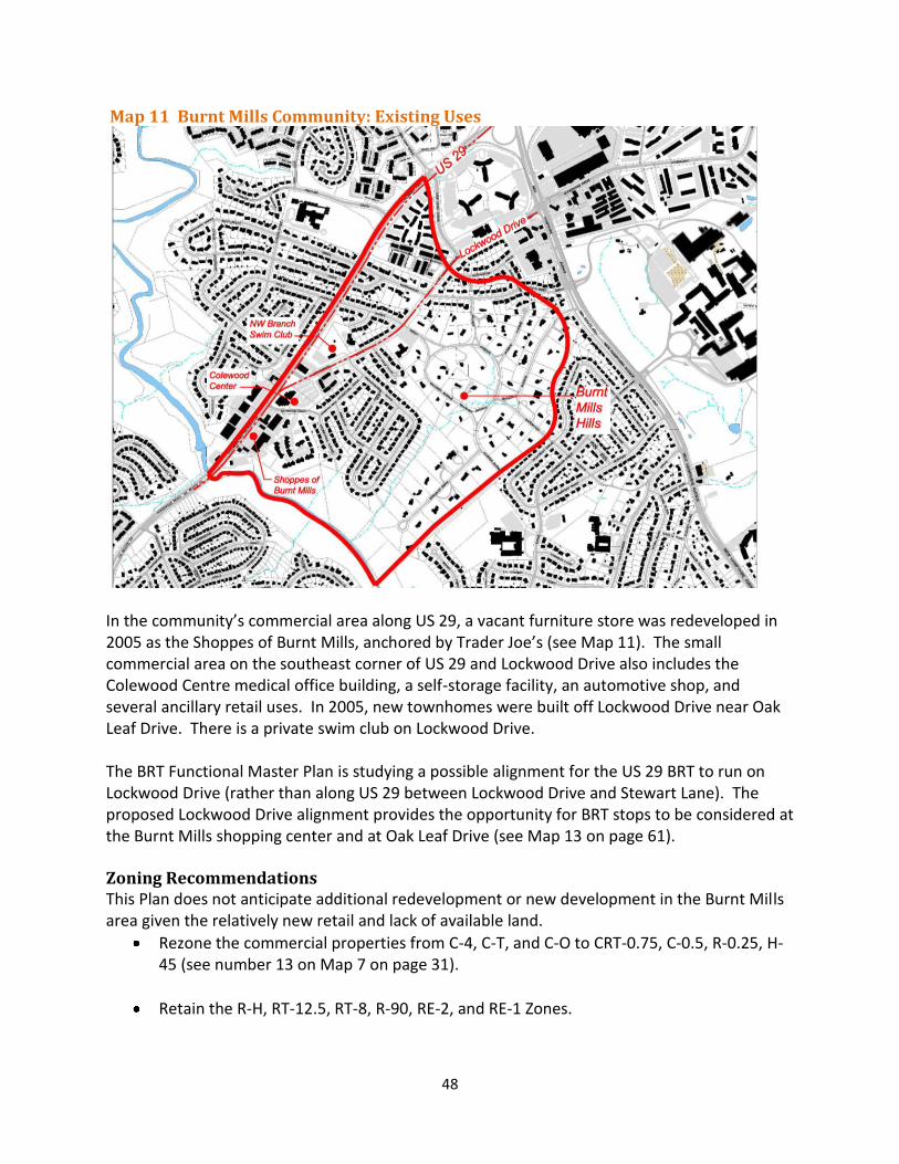
48
Map 11 Burnt Mills Community: Existing Uses
In the community’s commercial area along US 29, a vacant furniture store was redeveloped in 2005 as the Shoppes of Burnt Mills, anchored by Trader Joe’s (see Map 11). The small commercial area on the southeast corner of US 29 and Lockwood Drive also includes the Colewood Centre medical office building, a self-storage facility, an automotive shop, and several ancillary retail uses. In 2005, new townhomes were built off Lockwood Drive near Oak Leaf Drive. There is a private swim club on Lockwood Drive. The BRT Functional Master Plan is studying a possible alignment for the US 29 BRT to run on Lockwood Drive (rather than along US 29 between Lockwood Drive and Stewart Lane). The proposed Lockwood Drive alignment provides the opportunity for BRT stops to be considered at the Burnt Mills shopping center and at Oak Leaf Drive (see Map 13 on page 61). Zoning Recommendations This Plan does not anticipate additional redevelopment or new development in the Burnt Mills area given the relatively new retail and lack of available land.
Rezone the commercial properties from C-4, C-T, and C-O to CRT-0.75, C-0.5, R-0.25, H-45 (see number 13 on Map 7 on page 31).
Retain the R-H, RT-12.5, RT-8, R-90, RE-2, and RE-1 Zones.
49
TRANSPORTATION The White Oak area is near a number of major, regional roadways that serve both regional and local traffic (see Map 12). Interstate 95 parallels US 29 two and a half miles to the east in Prince George’s County. I-495 forms the southern boundary of the Plan area, with an interchange at New Hampshire Avenue. The 18-mile Intercounty Connector (MD 200) runs east-west between I-95 and I-270 with access via full interchanges on US 29 and New Hampshire Avenue and a partial interchange at Briggs Chaney Road (entrance only for westbound traffic). In the Plan area, two major highways – US 29 and New Hampshire Avenue – intersect at an interchange and connect the communities of White Oak to each other and to the surrounding region. US 29, the major north-south transportation facility in the eastern County, extends 26 miles from the Maryland/Washington, D.C. line to Howard County. New Hampshire Avenue, which originates in Washington, D.C., traverses Prince George’s County before it crosses into Montgomery County where it extends about 25 miles from the County line to MD 108. US 29 is the most critical roadway for this Plan due to its potential impacts on development and the area’s future. Transportation problems, and attempts to solve or relieve traffic congestion, have characterized the eastern County for 30 years. The 1981 Master Plan for Eastern Montgomery County Planning Area devised a concept called “transit serviceability” that was deemed problematic and no longer appropriate by the 1997 Master Plans. In 1986, the County imposed a development moratorium in the eastern County through the Adequate Public Facilities Ordinance. In 1990, the County Council adopted a Trip Reduction Amendment to the 1989 Plan. Development has continued to the north in Howard County, increasing regional travel demand and traffic volumes in the US 29 corridor. Like many suburban locales, the White Oak area has limited options for new vehicular connections. This area is particularly constrained by existing development, ownership patterns, the large federal property, and environmental resources. These physical constraints limit opportunities to improve circulation and connectivity, which forces all local traffic onto the major highways. Public access through the Federal Research Center, which could provide a local connection between New Hampshire Avenue and Cherry Hill Road, is not allowed. The transportation network serving this area will require high quality transit improvements as well as additional road infrastructure to support the potential development envisioned by this Plan. The Plan recommends major infrastructure projects, including a Bus Rapid Transit network, which are phased to support future growth. A biennial monitoring program will assess the pace of development and the need for infrastructure delivery.
50
Traffic Modeling Analysis A traffic modeling analysis of three different scenarios was conducted to determine the adequacy of the roadway network assumed in each scenario and to identify potential improvements to support development that would achieve the Plan vision. The three scenarios were:
1. The Existing Conditions scenario included all existing development and the existing transportation network.
2. The 2040 Round 8.0 COG Forecast scenario included existing development, pipeline, and
some additional development based on existing zoning. It did not include the proposed BRT network. It did include the grade-separated interchanges on US 29 recommended by the 1997 Plans at Stewart Lane, Industrial Parkway/Tech Road (within the Plan area) and at Musgrove Road, Fairland Road, Greencastle Road and Blackburn Road (outside the Plan area). These interchanges, with the exception of US 29 at Industrial Parkway/Tech Road, are currently in the State’s FY 12-16 Consolidated Transportation Program. This scenario also included extending Industrial Parkway through Site 2 to connect with FDA Boulevard.
3. The Alternative Master Plan Scenario assumed a significantly higher level of
development based on the land use associated with the Plan vision for the three major activity centers at White Oak/FDA, Hillandale, and North White Oak/Cherry Hill. It included all of the grade-separated interchanges and road improvements assumed in the 2040 scenario with the addition of rebuilding and reopening the Old Columbia Pike bridge over Paint Branch (that parallels US 29) to vehicular traffic. This scenario also assumed a BRT network.
The Plan area is located within the Fairland/White Oak Policy Area, which covers most of the eastern County. The traffic modeling analysis included a review of the forecasted speed of travel by automobile for the policy area using the Transportation Policy Area Review (TPAR) methodology. Land use and transportation infrastructure is forecasted to be out of balance in the Fairland/White Oak Policy Area at build-out of the alternative Plan scenario as measured by the Subdivision Staging Policy’s TPAR roadway adequacy test. The TPAR test evaluates the forecasted speed of travel on each arterial road within the policy area in its peak direction of travel (as derived from the regional transportation demand model) against uncongested, “free flow” speed, and weight-averages the results of all arterials in a policy area by vehicle miles of travel (VMT). The ratio of forecasted speed to uncongested speed is consistent with the type of analysis recommended by the Transportation Research Board’s Highway Capacity Manual (HCM). The Subdivision Staging Policy’s roadway adequacy standard for the Fairland/White Oak Policy Area is a minimum 45 percent ratio of forecast speed to uncongested speed (mid-point of Level of Service “D”). A ratio that is lower than this standard is considered to be inadequate. For the Fairland/White Oak Policy Area, a TPAR analysis was performed assuming that the level of
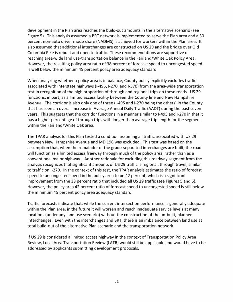
51
development in the Plan area reaches the build-out amounts in the alternative scenario (see Figure 5). This analysis assumed a BRT network is implemented to serve the Plan area and a 30 percent non-auto driver mode share (NADMS) is achieved for workers within the Plan area. It also assumed that additional interchanges are constructed on US 29 and the bridge over Old Columbia Pike is rebuilt and open to traffic. These recommendations are supportive of reaching area-wide land use-transportation balance in the Fairland/White Oak Policy Area. However, the resulting policy area ratio of 38 percent of forecast speed to uncongested speed is well below the minimum 45 percent policy area adequacy standard. When analyzing whether a policy area is in balance, County policy explicitly excludes traffic associated with interstate highways (I-495, I-270, and I-370) from the area-wide transportation test in recognition of the high proportion of through and regional trips on these roads. US 29 functions, in part, as a limited access facility between the County line and New Hampshire Avenue. The corridor is also only one of three (I-495 and I-270 being the others) in the County that has seen an overall increase in Average Annual Daily Traffic (AADT) during the past seven years. This suggests that the corridor functions in a manner similar to I-495 and I-270 in that it has a higher percentage of through trips with longer than average trip length for the segment within the Fairland/White Oak area. The TPAR analysis for this Plan tested a condition assuming all traffic associated with US 29 between New Hampshire Avenue and MD 198 was excluded. This test was based on the assumption that, when the remainder of the grade-separated interchanges are built, the road will function as a limited access freeway through much of the policy area, rather than as a conventional major highway. Another rationale for excluding this roadway segment from the analysis recognizes that significant amounts of US 29 traffic is regional, through travel, similar to traffic on I-270. In the context of this test, the TPAR analysis estimates the ratio of forecast speed to uncongested speed in the policy area to be 42 percent, which is a significant improvement from the 38 percent ratio that included all US 29 traffic (see Figures 5 and 6). However, the policy area 42 percent ratio of forecast speed to uncongested speed is still below the minimum 45 percent policy area adequacy standard. Traffic forecasts indicate that, while the current intersection performance is generally adequate within the Plan area, in the future it will worsen and reach inadequate service levels at many locations (under any land use scenario) without the construction of the un-built, planned interchanges. Even with the interchanges and BRT, there is an imbalance between land use at total build-out of the alternative Plan scenario and the transportation network. If US 29 is considered a limited access highway in the context of Transportation Policy Area Review, Local Area Transportation Review (LATR) would still be applicable and would have to be addressed by applicants submitting development proposals.
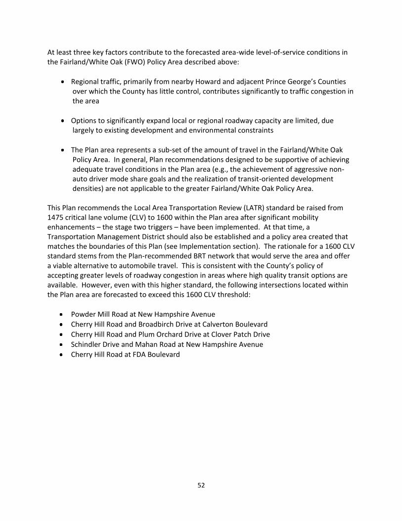
52
At least three key factors contribute to the forecasted area-wide level-of-service conditions in the Fairland/White Oak (FWO) Policy Area described above:
Regional traffic, primarily from nearby Howard and adjacent Prince George’s Counties over which the County has little control, contributes significantly to traffic congestion in the area
Options to significantly expand local or regional roadway capacity are limited, due largely to existing development and environmental constraints
The Plan area represents a sub-set of the amount of travel in the Fairland/White Oak Policy Area. In general, Plan recommendations designed to be supportive of achieving adequate travel conditions in the Plan area (e.g., the achievement of aggressive non-auto driver mode share goals and the realization of transit-oriented development densities) are not applicable to the greater Fairland/White Oak Policy Area.
This Plan recommends the Local Area Transportation Review (LATR) standard be raised from 1475 critical lane volume (CLV) to 1600 within the Plan area after significant mobility enhancements – the stage two triggers – have been implemented. At that time, a Transportation Management District should also be established and a policy area created that matches the boundaries of this Plan (see Implementation section). The rationale for a 1600 CLV standard stems from the Plan-recommended BRT network that would serve the area and offer a viable alternative to automobile travel. This is consistent with the County’s policy of accepting greater levels of roadway congestion in areas where high quality transit options are available. However, even with this higher standard, the following intersections located within the Plan area are forecasted to exceed this 1600 CLV threshold:
Powder Mill Road at New Hampshire Avenue
Cherry Hill Road and Broadbirch Drive at Calverton Boulevard
Cherry Hill Road and Plum Orchard Drive at Clover Patch Drive
Schindler Drive and Mahan Road at New Hampshire Avenue
Cherry Hill Road at FDA Boulevard
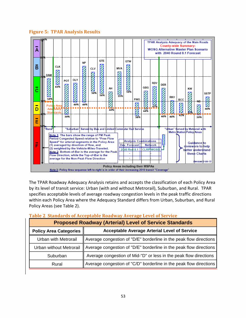
53
Figure 5: TPAR Analysis Results
The TPAR Roadway Adequacy Analysis retains and accepts the classification of each Policy Area by its level of transit service: Urban (with and without Metrorail), Suburban, and Rural. TPAR specifies acceptable levels of average roadway congestion levels in the peak traffic directions within each Policy Area where the Adequacy Standard differs from Urban, Suburban, and Rural Policy Areas (see Table 2).
Table 2 Standards of Acceptable Roadway Average Level of Service
Policy Area Categories
Urban with Metrorail
Urban without Metrorail
Suburban
Rural
Average congestion of Mid-"D" or less in the peak flow directions
Average congestion of "C/D" borderline in the peak flow directions
Acceptable Average Arterial Level of Service
Proposed Roadway (Arterial) Level of Service Standards
Average congestion of "D/E" borderline in the peak flow directions
Average congestion of "D/E" borderline in the peak flow directions
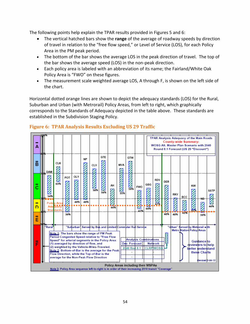
54
The following points help explain the TPAR results provided in Figures 5 and 6:
The vertical hatched bars show the range of the average of roadway speeds by direction of travel in relation to the “free flow speed,” or Level of Service (LOS), for each Policy Area in the PM peak period.
The bottom of the bar shows the average LOS in the peak direction of travel. The top of the bar shows the average speed (LOS) in the non-peak direction.
Each policy area is labeled with an abbreviation of its name; the Fairland/White Oak Policy Area is “FWO” on these figures.
The measurement scale weighted average LOS, A through F, is shown on the left side of the chart.
Horizontal dotted orange lines are shown to depict the adequacy standards (LOS) for the Rural, Suburban and Urban (with Metrorail) Policy Areas, from left to right, which graphically corresponds to the Standards of Adequacy depicted in the table above. These standards are established in the Subdivision Staging Policy.
Figure 6: TPAR Analysis Results Excluding US 29 Traffic
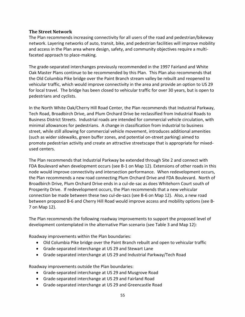
55
The Street Network The Plan recommends increasing connectivity for all users of the road and pedestrian/bikeway network. Layering networks of auto, transit, bike, and pedestrian facilities will improve mobility and access in the Plan area where design, safety, and community objectives require a multi-faceted approach to place-making. The grade-separated interchanges previously recommended in the 1997 Fairland and White Oak Master Plans continue to be recommended by this Plan. This Plan also recommends that the Old Columbia Pike bridge over the Paint Branch stream valley be rebuilt and reopened to vehicular traffic, which would improve connectivity in the area and provide an option to US 29 for local travel. The bridge has been closed to vehicular traffic for over 30 years, but is open to pedestrians and cyclists. In the North White Oak/Cherry Hill Road Center, the Plan recommends that Industrial Parkway, Tech Road, Broadbirch Drive, and Plum Orchard Drive be reclassified from Industrial Roads to Business District Streets. Industrial roads are intended for commercial vehicle circulation, with minimal allowances for pedestrians. A change in classification from industrial to business street, while still allowing for commercial vehicle movement, introduces additional amenities (such as wider sidewalks, green buffer zones, and potential on-street parking) aimed to promote pedestrian activity and create an attractive streetscape that is appropriate for mixed-used centers.
The Plan recommends that Industrial Parkway be extended through Site 2 and connect with FDA Boulevard when development occurs (see B-1 on Map 12). Extensions of other roads in this node would improve connectivity and intersection performance. When redevelopment occurs, the Plan recommends a new road connecting Plum Orchard Drive and FDA Boulevard. North of Broadbirch Drive, Plum Orchard Drive ends in a cul-de-sac as does Whitehorn Court south of Prosperity Drive. If redevelopment occurs, the Plan recommends that a new vehicular connection be made between these two cul-de-sacs (see B-6 on Map 12). Also, a new road between proposed B-6 and Cherry Hill Road would improve access and mobility options (see B-7 on Map 12). The Plan recommends the following roadway improvements to support the proposed level of development contemplated in the alternative Plan scenario (see Table 3 and Map 12): Roadway improvements within the Plan boundaries:
Old Columbia Pike bridge over the Paint Branch rebuilt and open to vehicular traffic
Grade-separated interchange at US 29 and Stewart Lane
Grade-separated interchange at US 29 and Industrial Parkway/Tech Road
Roadway improvements outside the Plan boundaries:
Grade-separated interchange at US 29 and Musgrove Road
Grade-separated interchange at US 29 and Fairland Road
Grade-separated interchange at US 29 and Greencastle Road
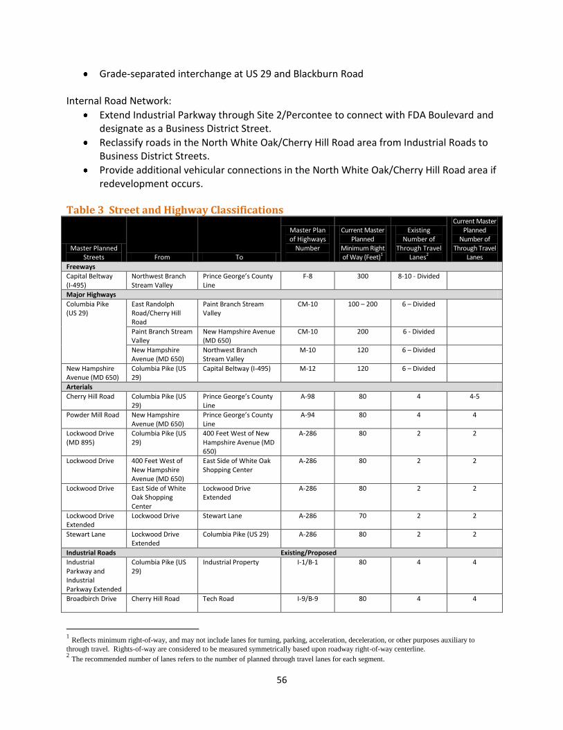
56
Grade-separated interchange at US 29 and Blackburn Road Internal Road Network:
Extend Industrial Parkway through Site 2/Percontee to connect with FDA Boulevard and designate as a Business District Street.
Reclassify roads in the North White Oak/Cherry Hill Road area from Industrial Roads to Business District Streets.
Provide additional vehicular connections in the North White Oak/Cherry Hill Road area if redevelopment occurs.
Table 3 Street and Highway Classifications
Master Planned Streets From To
Master Plan of Highways
Number
Current Master Planned
Minimum Right of Way (Feet)1
Existing Number of
Through Travel Lanes2
Current Master Planned
Number of Through Travel
Lanes
Freeways
Capital Beltway (I-495)
Northwest Branch Stream Valley
Prince George’s County Line
F-8 300 8-10 - Divided
Major Highways
Columbia Pike (US 29)
East Randolph Road/Cherry Hill Road
Paint Branch Stream Valley
CM-10 100 – 200 6 – Divided
Paint Branch Stream Valley
New Hampshire Avenue (MD 650)
CM-10 200 6 - Divided
New Hampshire Avenue (MD 650)
Northwest Branch Stream Valley
M-10 120 6 – Divided
New Hampshire Avenue (MD 650)
Columbia Pike (US 29)
Capital Beltway (I-495) M-12 120 6 – Divided
Arterials
Cherry Hill Road Columbia Pike (US 29)
Prince George’s County Line
A-98 80 4 4-5
Powder Mill Road New Hampshire Avenue (MD 650)
Prince George’s County Line
A-94 80 4 4
Lockwood Drive (MD 895)
Columbia Pike (US 29)
400 Feet West of New Hampshire Avenue (MD 650)
A-286 80 2 2
Lockwood Drive 400 Feet West of New Hampshire Avenue (MD 650)
East Side of White Oak Shopping Center
A-286 80 2 2
Lockwood Drive East Side of White Oak Shopping Center
Lockwood Drive Extended
A-286 80 2 2
Lockwood Drive Extended
Lockwood Drive Stewart Lane A-286 70 2 2
Stewart Lane Lockwood Drive Extended
Columbia Pike (US 29) A-286 80 2 2
Industrial Roads Existing/Proposed
Industrial Parkway and Industrial Parkway Extended
Columbia Pike (US 29)
Industrial Property I-1/B-1 80 4 4
Broadbirch Drive
Cherry Hill Road Tech Road I-9/B-9 80 4 4
1 Reflects minimum right-of-way, and may not include lanes for turning, parking, acceleration, deceleration, or other purposes auxiliary to
through travel. Rights-of-way are considered to be measured symmetrically based upon roadway right-of-way centerline. 2 The recommended number of lanes refers to the number of planned through travel lanes for each segment.
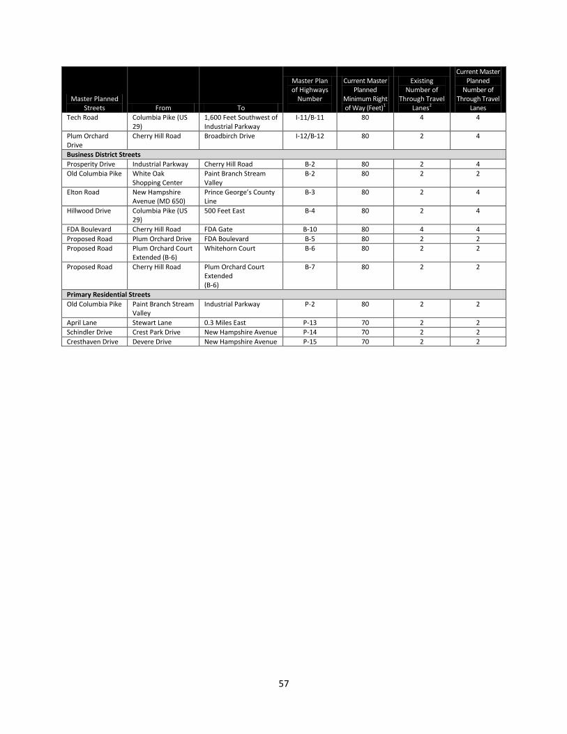
57
Master Planned Streets From To
Master Plan of Highways
Number
Current Master Planned
Minimum Right of Way (Feet)1
Existing Number of
Through Travel Lanes2
Current Master Planned
Number of Through Travel
Lanes
Tech Road Columbia Pike (US 29)
1,600 Feet Southwest of Industrial Parkway
I-11/B-11 80 4 4
Plum Orchard Drive
Cherry Hill Road Broadbirch Drive I-12/B-12 80 2 4
Business District Streets
Prosperity Drive Industrial Parkway Cherry Hill Road B-2 80 2 4
Old Columbia Pike White Oak Shopping Center
Paint Branch Stream Valley
B-2 80 2 2
Elton Road New Hampshire Avenue (MD 650)
Prince George’s County Line
B-3 80 2 4
Hillwood Drive Columbia Pike (US 29)
500 Feet East B-4 80 2 4
FDA Boulevard Cherry Hill Road FDA Gate B-10 80 4 4
Proposed Road Plum Orchard Drive FDA Boulevard B-5 80 2 2
Proposed Road Plum Orchard Court Extended (B-6)
Whitehorn Court B-6 80 2 2
Proposed Road Cherry Hill Road Plum Orchard Court Extended (B-6)
B-7 80 2 2
Primary Residential Streets
Old Columbia Pike Paint Branch Stream Valley
Industrial Parkway P-2 80 2 2
April Lane Stewart Lane 0.3 Miles East P-13 70 2 2
Schindler Drive Crest Park Drive New Hampshire Avenue P-14 70 2 2
Cresthaven Drive Devere Drive New Hampshire Avenue P-15 70 2 2
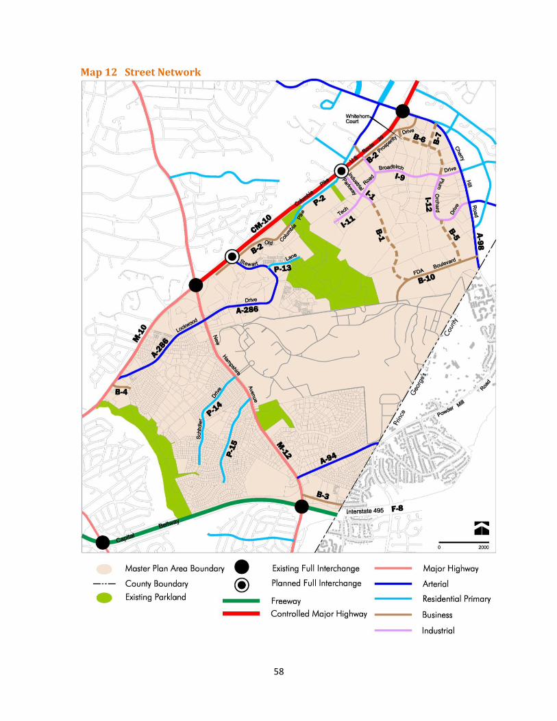
58
Map 12 Street Network
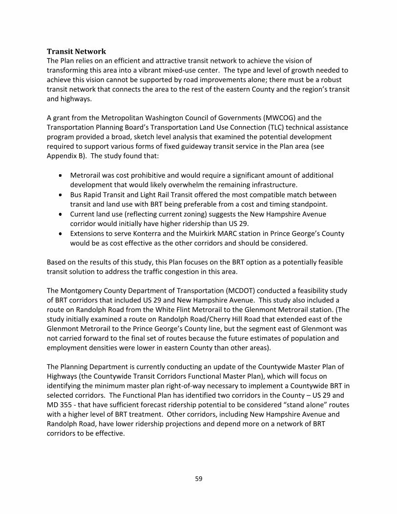
59
Transit Network The Plan relies on an efficient and attractive transit network to achieve the vision of transforming this area into a vibrant mixed-use center. The type and level of growth needed to achieve this vision cannot be supported by road improvements alone; there must be a robust transit network that connects the area to the rest of the eastern County and the region’s transit and highways. A grant from the Metropolitan Washington Council of Governments (MWCOG) and the Transportation Planning Board’s Transportation Land Use Connection (TLC) technical assistance program provided a broad, sketch level analysis that examined the potential development required to support various forms of fixed guideway transit service in the Plan area (see Appendix B). The study found that:
Metrorail was cost prohibitive and would require a significant amount of additional development that would likely overwhelm the remaining infrastructure.
Bus Rapid Transit and Light Rail Transit offered the most compatible match between transit and land use with BRT being preferable from a cost and timing standpoint.
Current land use (reflecting current zoning) suggests the New Hampshire Avenue corridor would initially have higher ridership than US 29.
Extensions to serve Konterra and the Muirkirk MARC station in Prince George’s County would be as cost effective as the other corridors and should be considered.
Based on the results of this study, this Plan focuses on the BRT option as a potentially feasible transit solution to address the traffic congestion in this area. The Montgomery County Department of Transportation (MCDOT) conducted a feasibility study of BRT corridors that included US 29 and New Hampshire Avenue. This study also included a route on Randolph Road from the White Flint Metrorail to the Glenmont Metrorail station. (The study initially examined a route on Randolph Road/Cherry Hill Road that extended east of the Glenmont Metrorail to the Prince George’s County line, but the segment east of Glenmont was not carried forward to the final set of routes because the future estimates of population and employment densities were lower in eastern County than other areas). The Planning Department is currently conducting an update of the Countywide Master Plan of Highways (the Countywide Transit Corridors Functional Master Plan), which will focus on identifying the minimum master plan right-of-way necessary to implement a Countywide BRT in selected corridors. The Functional Plan has identified two corridors in the County – US 29 and MD 355 - that have sufficient forecast ridership potential to be considered “stand alone” routes with a higher level of BRT treatment. Other corridors, including New Hampshire Avenue and Randolph Road, have lower ridership projections and depend more on a network of BRT corridors to be effective.
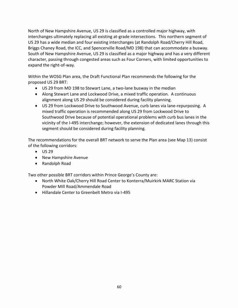
60
North of New Hampshire Avenue, US 29 is classified as a controlled major highway, with interchanges ultimately replacing all existing at-grade intersections. This northern segment of US 29 has a wide median and four existing interchanges (at Randolph Road/Cherry Hill Road, Briggs Chaney Road, the ICC, and Spencerville Road/MD 198) that can accommodate a busway. South of New Hampshire Avenue, US 29 is classified as a major highway and has a very different character, passing through congested areas such as Four Corners, with limited opportunities to expand the right-of-way. Within the WOSG Plan area, the Draft Functional Plan recommends the following for the proposed US 29 BRT:
US 29 from MD 198 to Stewart Lane, a two-lane busway in the median
Along Stewart Lane and Lockwood Drive, a mixed traffic operation. A continuous alignment along US 29 should be considered during facility planning.
US 29 from Lockwood Drive to Southwood Avenue, curb lanes via lane-repurposing. A mixed traffic operation is recommended along US 29 from Lockwood Drive to Southwood Drive because of potential operational problems with curb bus lanes in the vicinity of the I-495 interchange; however, the extension of dedicated lanes through this segment should be considered during facility planning.
The recommendations for the overall BRT network to serve the Plan area (see Map 13) consist of the following corridors:
US 29
New Hampshire Avenue
Randolph Road
Two other possible BRT corridors within Prince George’s County are:
North White Oak/Cherry Hill Road Center to Konterra/Muirkirk MARC Station via Powder Mill Road/Ammendale Road
Hillandale Center to Greenbelt Metro via I-495
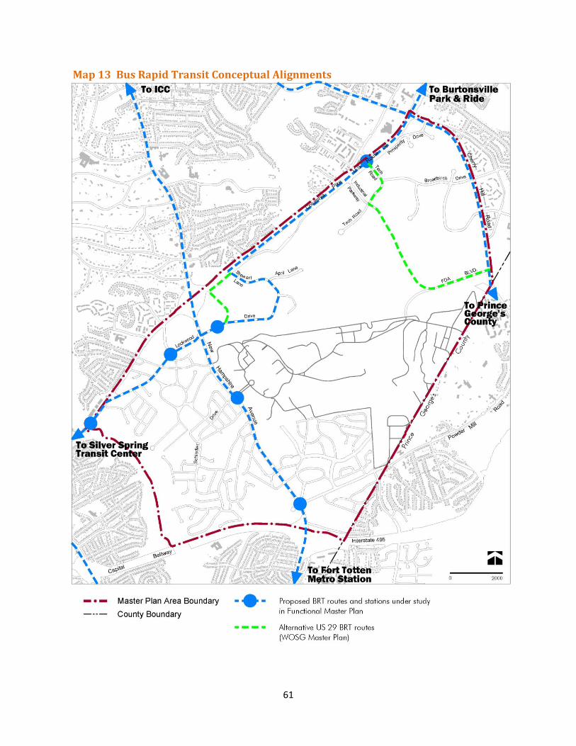
61
Map 13 Bus Rapid Transit Conceptual Alignments
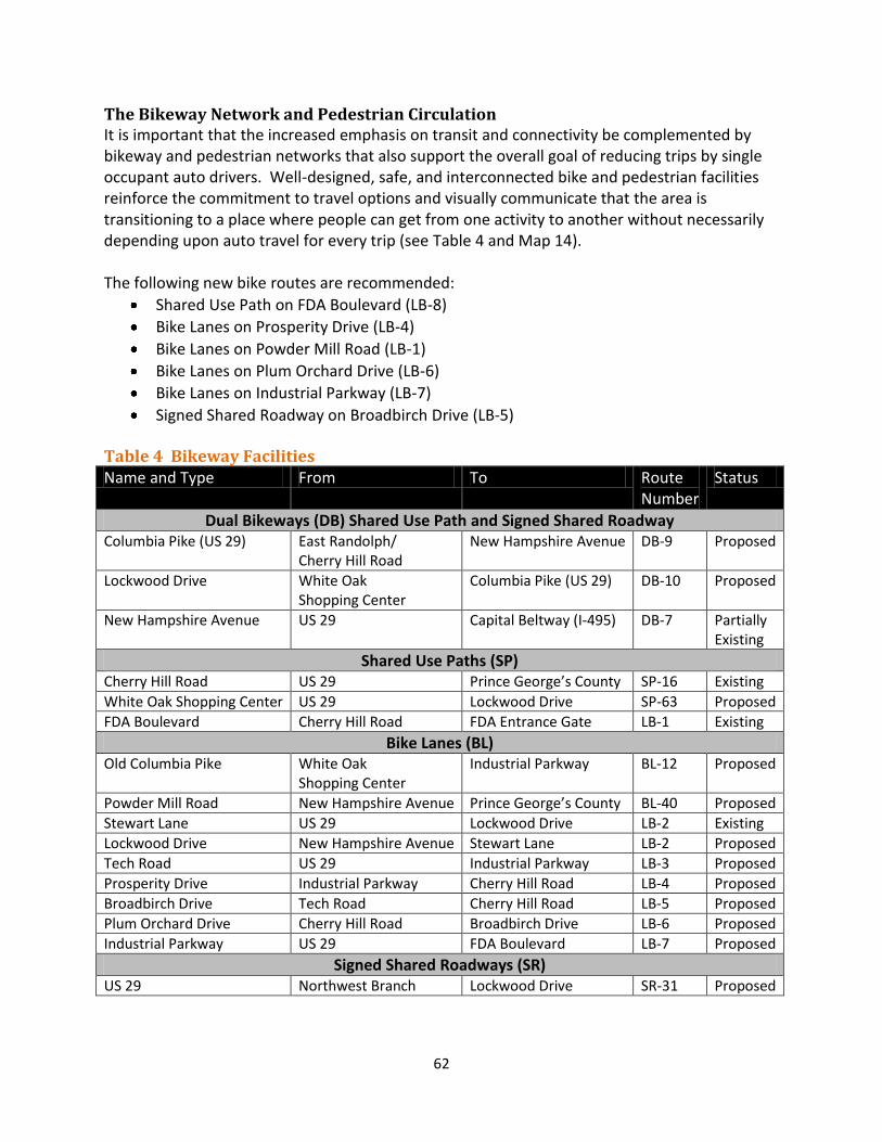
62
The Bikeway Network and Pedestrian Circulation It is important that the increased emphasis on transit and connectivity be complemented by bikeway and pedestrian networks that also support the overall goal of reducing trips by single occupant auto drivers. Well-designed, safe, and interconnected bike and pedestrian facilities reinforce the commitment to travel options and visually communicate that the area is transitioning to a place where people can get from one activity to another without necessarily depending upon auto travel for every trip (see Table 4 and Map 14).
The following new bike routes are recommended:
Shared Use Path on FDA Boulevard (LB-8)
Bike Lanes on Prosperity Drive (LB-4)
Bike Lanes on Powder Mill Road (LB-1)
Bike Lanes on Plum Orchard Drive (LB-6)
Bike Lanes on Industrial Parkway (LB-7)
Signed Shared Roadway on Broadbirch Drive (LB-5) Table 4 Bikeway Facilities Name and Type From To Route
Number Status
Dual Bikeways (DB) Shared Use Path and Signed Shared Roadway Columbia Pike (US 29) East Randolph/
Cherry Hill Road New Hampshire Avenue DB-9 Proposed
Lockwood Drive White Oak Shopping Center
Columbia Pike (US 29) DB-10 Proposed
New Hampshire Avenue US 29 Capital Beltway (I-495) DB-7 Partially Existing
Shared Use Paths (SP) Cherry Hill Road US 29 Prince George’s County SP-16 Existing
White Oak Shopping Center US 29 Lockwood Drive SP-63 Proposed
FDA Boulevard Cherry Hill Road FDA Entrance Gate LB-1 Existing
Bike Lanes (BL) Old Columbia Pike White Oak
Shopping Center Industrial Parkway BL-12 Proposed
Powder Mill Road New Hampshire Avenue Prince George’s County BL-40 Proposed
Stewart Lane US 29 Lockwood Drive LB-2 Existing
Lockwood Drive New Hampshire Avenue Stewart Lane LB-2 Proposed
Tech Road US 29 Industrial Parkway LB-3 Proposed
Prosperity Drive Industrial Parkway Cherry Hill Road LB-4 Proposed
Broadbirch Drive Tech Road Cherry Hill Road LB-5 Proposed
Plum Orchard Drive Cherry Hill Road Broadbirch Drive LB-6 Proposed
Industrial Parkway US 29 FDA Boulevard LB-7 Proposed
Signed Shared Roadways (SR) US 29 Northwest Branch Lockwood Drive SR-31 Proposed
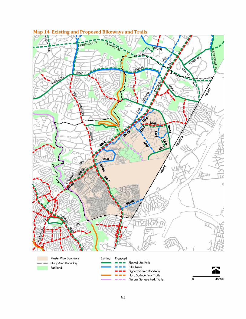
63
Map 14 Existing and Proposed Bikeways and Trails
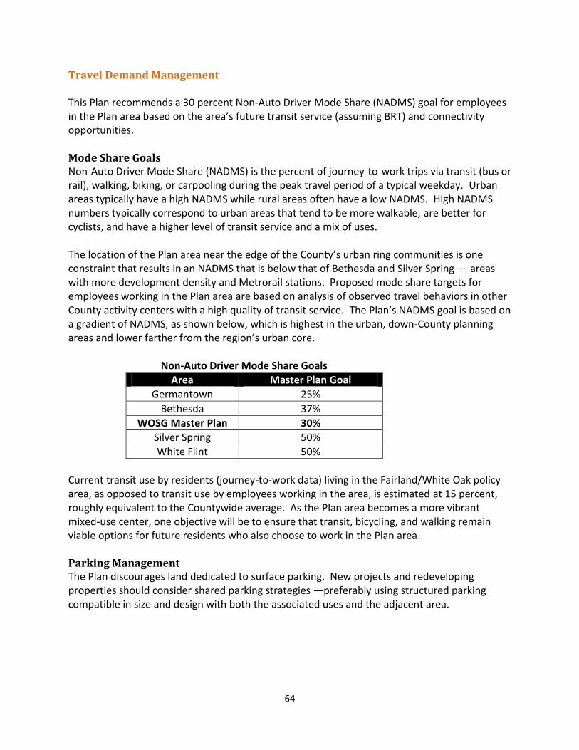
64
Travel Demand Management This Plan recommends a 30 percent Non-Auto Driver Mode Share (NADMS) goal for employees in the Plan area based on the area’s future transit service (assuming BRT) and connectivity opportunities. Mode Share Goals Non-Auto Driver Mode Share (NADMS) is the percent of journey-to-work trips via transit (bus or rail), walking, biking, or carpooling during the peak travel period of a typical weekday. Urban areas typically have a high NADMS while rural areas often have a low NADMS. High NADMS numbers typically correspond to urban areas that tend to be more walkable, are better for cyclists, and have a higher level of transit service and a mix of uses. The location of the Plan area near the edge of the County’s urban ring communities is one constraint that results in an NADMS that is below that of Bethesda and Silver Spring — areas with more development density and Metrorail stations. Proposed mode share targets for employees working in the Plan area are based on analysis of observed travel behaviors in other County activity centers with a high quality of transit service. The Plan’s NADMS goal is based on a gradient of NADMS, as shown below, which is highest in the urban, down-County planning areas and lower farther from the region’s urban core. Non-Auto Driver Mode Share Goals
Area Master Plan Goal
Germantown 25%
Bethesda 37%
WOSG Master Plan 30%
Silver Spring 50%
White Flint 50%
Current transit use by residents (journey-to-work data) living in the Fairland/White Oak policy area, as opposed to transit use by employees working in the area, is estimated at 15 percent, roughly equivalent to the Countywide average. As the Plan area becomes a more vibrant mixed-use center, one objective will be to ensure that transit, bicycling, and walking remain viable options for future residents who also choose to work in the Plan area. Parking Management The Plan discourages land dedicated to surface parking. New projects and redeveloping properties should consider shared parking strategies —preferably using structured parking compatible in size and design with both the associated uses and the adjacent area.
65
The Plan proposes leveraging the County’s ownership of properties currently used for public parking lots to attract mixed-use development that will include public parking structures. The proposed CR Zones facilitate the provision of publicly available parking, and the County is investigating alternative parking management schemes to promote the most effective use of Parking Lot District resources.
Encourage a balance of short- and long-term on-street parking within the activity nodes. Retain some convenient parking for the BRT stations, but devote primary efforts to
ensure opportunities for BRT passengers to walk, use local bus service, or bike to and from the BRT stations.

66
67
NATURAL ENVIRONMENT Overall Goal White Oak is part of an established suburban community with a sense of place that is, in part, created by the unusual natural environment. As the Piedmont Plateau transitions to the Atlantic Coastal Plain at the “fall line” in this area, rolling hills and narrow valleys shift to more gently sloping hills and broad open streams. Geology associated with upland gravels and lowland coastal sand sediments are found in a narrow area between US 29 and the County line. This transition area is marked by waterfalls, steep slopes, quarries, and biodiversity areas. The overall environmental goal for this Plan is to allow development at higher densities without compromising the environmental quality of this unique area. Development should respect and incorporate the natural environment, including the topography. Resource Protection and Preservation The planning area is bisected by two major stream valleys. One edge of the Plan area is bordered by the Northwest Branch stream valley, which is primarily parkland. The Paint Branch stream valley crosses the Plan area and is partly enclosed by parkland and partly by the FRC property. The two stream valleys provide much of the natural beauty of the area and include biodiversity areas. However, the stream valleys can act as barriers to transportation connections. Both stream valleys are characterized by steep slopes and highly erodible soils that are predominantly protected by forest. This Plan identifies site-specific areas for reforestation and restoration to protect and enhance these sensitive areas. Recommendations
Avoid stream crossings and other impacts to natural resources as much as possible when altering or adding to the transportation network.
Where possible, use required forest and tree planting to enhance and expand existing resources, especially in stream valley buffers.
Minimize grading and preserve areas of steep slopes and highly erodible soils.
Minimize fragmentation of forest to preserve interior habitats.
Maximize invasive plant removal to maintain plant diversity.
Use native plants wherever possible to maximize habitat.
Minimize encroachment into the Paint Branch biodiversity area. Water Quality Water quality in developed areas is impacted by the replacement of natural surfaces by impervious surfaces that prevent infiltration and do not allow for the natural hydrologic cycle to function. Instead of infiltrating into the soil and contributing to the recharge of the stream systems, water runs off the impervious areas, increasing the temperature, speed, and pollutant concentrations of the water. Instead of streams recharging slowly, runoff rushes into the streams, causing flooding and erosion.
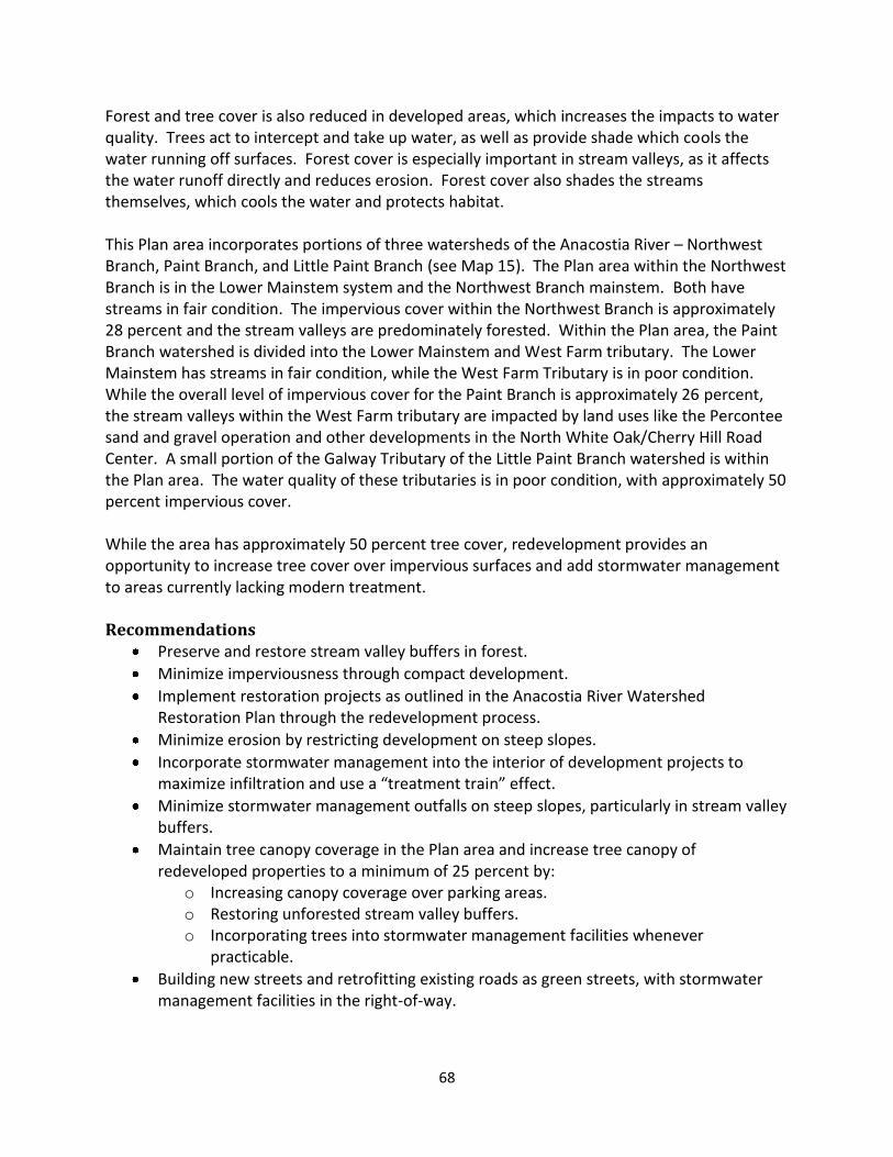
68
Forest and tree cover is also reduced in developed areas, which increases the impacts to water quality. Trees act to intercept and take up water, as well as provide shade which cools the water running off surfaces. Forest cover is especially important in stream valleys, as it affects the water runoff directly and reduces erosion. Forest cover also shades the streams themselves, which cools the water and protects habitat. This Plan area incorporates portions of three watersheds of the Anacostia River – Northwest Branch, Paint Branch, and Little Paint Branch (see Map 15). The Plan area within the Northwest Branch is in the Lower Mainstem system and the Northwest Branch mainstem. Both have streams in fair condition. The impervious cover within the Northwest Branch is approximately 28 percent and the stream valleys are predominately forested. Within the Plan area, the Paint Branch watershed is divided into the Lower Mainstem and West Farm tributary. The Lower Mainstem has streams in fair condition, while the West Farm Tributary is in poor condition. While the overall level of impervious cover for the Paint Branch is approximately 26 percent, the stream valleys within the West Farm tributary are impacted by land uses like the Percontee sand and gravel operation and other developments in the North White Oak/Cherry Hill Road Center. A small portion of the Galway Tributary of the Little Paint Branch watershed is within the Plan area. The water quality of these tributaries is in poor condition, with approximately 50 percent impervious cover. While the area has approximately 50 percent tree cover, redevelopment provides an opportunity to increase tree cover over impervious surfaces and add stormwater management to areas currently lacking modern treatment. Recommendations
Preserve and restore stream valley buffers in forest.
Minimize imperviousness through compact development.
Implement restoration projects as outlined in the Anacostia River Watershed Restoration Plan through the redevelopment process.
Minimize erosion by restricting development on steep slopes.
Incorporate stormwater management into the interior of development projects to maximize infiltration and use a “treatment train” effect.
Minimize stormwater management outfalls on steep slopes, particularly in stream valley buffers.
Maintain tree canopy coverage in the Plan area and increase tree canopy of redeveloped properties to a minimum of 25 percent by:
o Increasing canopy coverage over parking areas. o Restoring unforested stream valley buffers. o Incorporating trees into stormwater management facilities whenever
practicable.
Building new streets and retrofitting existing roads as green streets, with stormwater management facilities in the right-of-way.
69
Map 15 Watersheds and Streams
70
Air Quality/Climate Protection Redevelopment creates opportunities to reduce energy consumption, which helps improve air quality and protect our climate. Compact, mixed-use developments reduce vehicle miles travelled by providing destinations in closer proximities. Energy usage can be decreased by the use of newer building types and technologies, while development on larger parcels provides the greatest opportunity for energy production. Recommendations
Create opportunities for new development and redevelopment that take advantage of existing infrastructure and adaptive re-use of existing structures where appropriate.
Develop compact, mixed-use neighborhoods that are walkable.
Minimize urban heat island effect by o Maximizing tree cover over parking lots. o Using vegetated roofs or cool roofs. o Minimizing new surface parking and promote the sharing of existing parking lots.
Maximize use of renewable energy systems to supply a portion or all of a building’s energy demand. Alternative energy systems may include:
o Solar power o Wind power o Geothermal
Encourage local energy production on large properties to minimize power loss through
the distribution process.
Specific Property Recommendations Percontee The Percontee property is a sand and gravel operation, with a landform dramatically altered by the land use. The Percontee property is bisected by the West Farm tributary of the Paint Branch and is bordered on the west by the Lower Mainstem of the Paint Branch. The stream valleys are degraded and should be restored and reforested. Redevelopment of this site should improve the local environment by reducing the sediment load and adding a natural land cover. Recommendations
Orient development to maximize exposure to the natural environment while minimizing disturbance of buffers and retaining forest.
Avoid new stream crossings and use existing stream crossings, where possible, when redeveloping the site and creating a circulation system.
Minimize disturbance of steep slopes when new development occurs.
Restore and protect streams and buffers, while still allowing non-motorized access and visibility.
Work with adjacent property owners to create a trail system to take advantage of natural features.
Integrate stormwater management as urban design features.
71
Preserve and plant forest adjoining existing areas of forest on adjacent properties.
Investigate options for power generation.
Work with WSSC to ensure adequate sewer volume at time of development. o Minimize disturbance in Paint Branch and investigate option of extending the
sewer line in Cherry Hill Road.
Site 2 Site 2 is a grey field site that was previously used as a WSSC sludge composting facility. It is directly adjacent to the Paint Branch Stream Valley Park and contains several tributaries. The stream valleys are partially forested but present opportunities for restoration and reforestation. The location and quantity of groundwater is unknown due to the disturbed nature of the site. Additionally, there may be contamination from the previous industrial use, which will need to be remediated through the development process. Recommendations
Intensive investigation of subsurface conditions may be required at time of development.
Stream and buffer restoration efforts should coincide with any cleanup and removal of contaminated materials, if necessary. The actual extent and location of groundwater is not easily apparent due to the amount of fill on this site.
Development should be oriented to maximize exposure to the natural environment while minimizing disturbance of buffers and retaining forest.
Integrate stormwater management as urban design features.
Any trails should minimize encroachment into areas of steep slopes and environmental buffers.
White Oak Shopping Center The White Oak Shopping Center is almost completely paved and has no environmental features. All parking is provided by surface lots with no tree cover. Redevelopment provides an opportunity to reduce imperviousness and the impacts of development through site design. Recommendations
Minimize surface parking.
Provide 25 percent tree cover on this site.
Integrate stormwater management into redevelopment. National Labor College The National Labor College is partially forested with significant open space adjacent to the current development. The property is bisected by a piped Northwest Branch tributary with an associated floodplain. Redevelopment should preserve and be enhanced by the natural resources.

72
Recommendations Investigate options for daylighting and restoring the stream running through the center
of the property.
Maximize and enhance forest retention as a buffer to surrounding single-family communities.
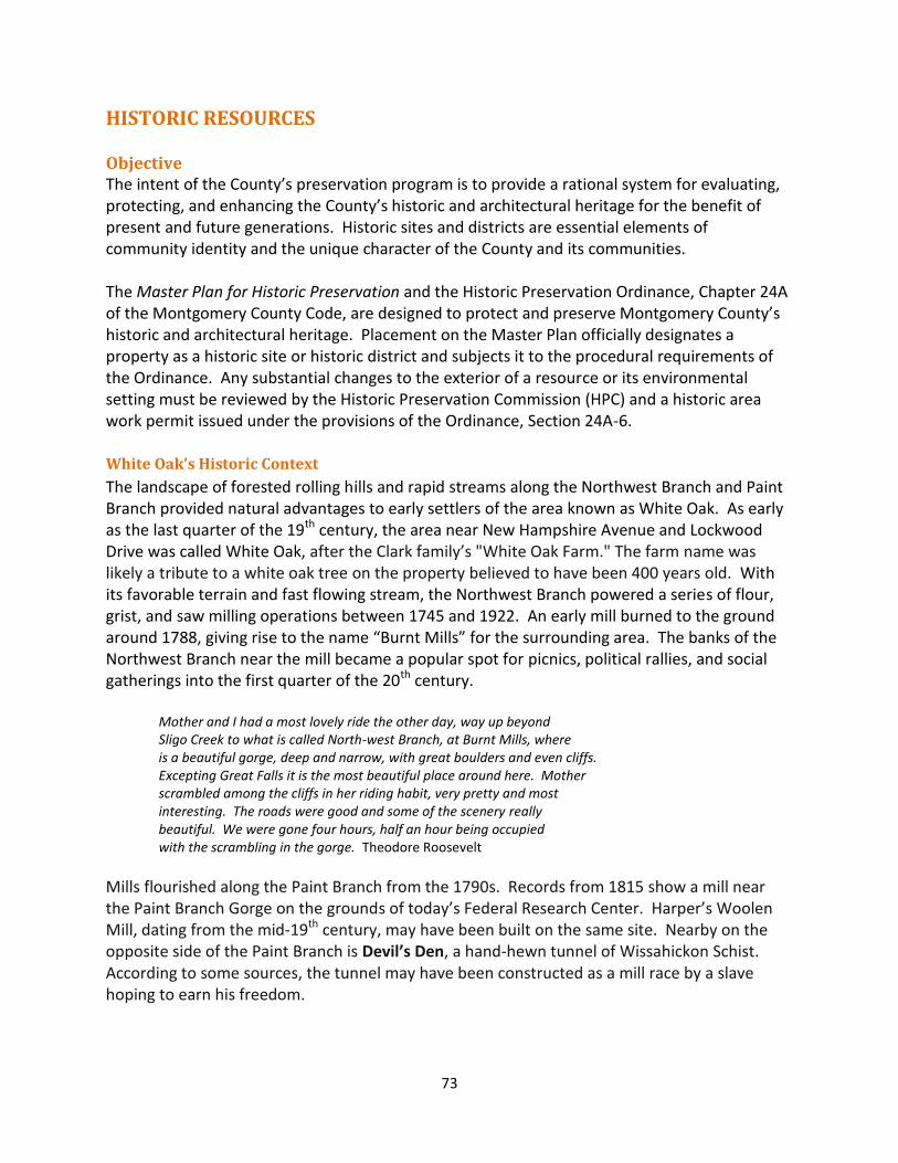
73
HISTORIC RESOURCES
Objective The intent of the County’s preservation program is to provide a rational system for evaluating, protecting, and enhancing the County’s historic and architectural heritage for the benefit of present and future generations. Historic sites and districts are essential elements of community identity and the unique character of the County and its communities. The Master Plan for Historic Preservation and the Historic Preservation Ordinance, Chapter 24A of the Montgomery County Code, are designed to protect and preserve Montgomery County’s historic and architectural heritage. Placement on the Master Plan officially designates a property as a historic site or historic district and subjects it to the procedural requirements of the Ordinance. Any substantial changes to the exterior of a resource or its environmental setting must be reviewed by the Historic Preservation Commission (HPC) and a historic area work permit issued under the provisions of the Ordinance, Section 24A-6.
White Oak’s Historic Context
The landscape of forested rolling hills and rapid streams along the Northwest Branch and Paint Branch provided natural advantages to early settlers of the area known as White Oak. As early as the last quarter of the 19th century, the area near New Hampshire Avenue and Lockwood Drive was called White Oak, after the Clark family’s "White Oak Farm." The farm name was likely a tribute to a white oak tree on the property believed to have been 400 years old. With its favorable terrain and fast flowing stream, the Northwest Branch powered a series of flour, grist, and saw milling operations between 1745 and 1922. An early mill burned to the ground around 1788, giving rise to the name “Burnt Mills” for the surrounding area. The banks of the Northwest Branch near the mill became a popular spot for picnics, political rallies, and social gatherings into the first quarter of the 20th century.
Mother and I had a most lovely ride the other day, way up beyond Sligo Creek to what is called North-west Branch, at Burnt Mills, where is a beautiful gorge, deep and narrow, with great boulders and even cliffs. Excepting Great Falls it is the most beautiful place around here. Mother scrambled among the cliffs in her riding habit, very pretty and most interesting. The roads were good and some of the scenery really beautiful. We were gone four hours, half an hour being occupied with the scrambling in the gorge. Theodore Roosevelt
Mills flourished along the Paint Branch from the 1790s. Records from 1815 show a mill near the Paint Branch Gorge on the grounds of today’s Federal Research Center. Harper’s Woolen Mill, dating from the mid-19th century, may have been built on the same site. Nearby on the opposite side of the Paint Branch is Devil’s Den, a hand-hewn tunnel of Wissahickon Schist. According to some sources, the tunnel may have been constructed as a mill race by a slave hoping to earn his freedom.
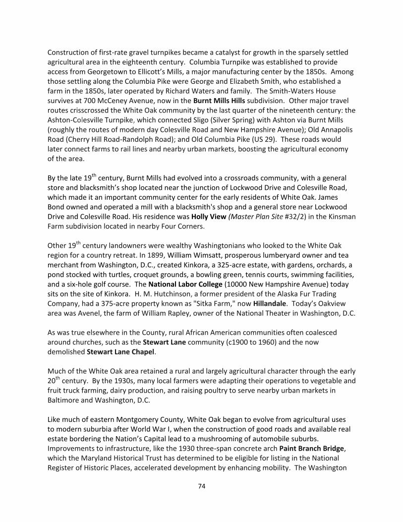
74
Construction of first-rate gravel turnpikes became a catalyst for growth in the sparsely settled agricultural area in the eighteenth century. Columbia Turnpike was established to provide access from Georgetown to Ellicott’s Mills, a major manufacturing center by the 1850s. Among those settling along the Columbia Pike were George and Elizabeth Smith, who established a farm in the 1850s, later operated by Richard Waters and family. The Smith-Waters House survives at 700 McCeney Avenue, now in the Burnt Mills Hills subdivision. Other major travel routes crisscrossed the White Oak community by the last quarter of the nineteenth century: the Ashton-Colesville Turnpike, which connected Sligo (Silver Spring) with Ashton via Burnt Mills (roughly the routes of modern day Colesville Road and New Hampshire Avenue); Old Annapolis Road (Cherry Hill Road-Randolph Road); and Old Columbia Pike (US 29). These roads would later connect farms to rail lines and nearby urban markets, boosting the agricultural economy of the area. By the late 19th century, Burnt Mills had evolved into a crossroads community, with a general store and blacksmith’s shop located near the junction of Lockwood Drive and Colesville Road, which made it an important community center for the early residents of White Oak. James Bond owned and operated a mill with a blacksmith's shop and a general store near Lockwood Drive and Colesville Road. His residence was Holly View (Master Plan Site #32/2) in the Kinsman Farm subdivision located in nearby Four Corners. Other 19th century landowners were wealthy Washingtonians who looked to the White Oak region for a country retreat. In 1899, William Wimsatt, prosperous lumberyard owner and tea merchant from Washington, D.C., created Kinkora, a 325-acre estate, with gardens, orchards, a pond stocked with turtles, croquet grounds, a bowling green, tennis courts, swimming facilities, and a six-hole golf course. The National Labor College (10000 New Hampshire Avenue) today sits on the site of Kinkora. H. M. Hutchinson, a former president of the Alaska Fur Trading Company, had a 375-acre property known as "Sitka Farm," now Hillandale. Today’s Oakview area was Avenel, the farm of William Rapley, owner of the National Theater in Washington, D.C. As was true elsewhere in the County, rural African American communities often coalesced around churches, such as the Stewart Lane community (c1900 to 1960) and the now demolished Stewart Lane Chapel. Much of the White Oak area retained a rural and largely agricultural character through the early 20th century. By the 1930s, many local farmers were adapting their operations to vegetable and fruit truck farming, dairy production, and raising poultry to serve nearby urban markets in Baltimore and Washington, D.C. Like much of eastern Montgomery County, White Oak began to evolve from agricultural uses to modern suburbia after World War I, when the construction of good roads and available real estate bordering the Nation’s Capital lead to a mushrooming of automobile suburbs. Improvements to infrastructure, like the 1930 three-span concrete arch Paint Branch Bridge, which the Maryland Historical Trust has determined to be eligible for listing in the National Register of Historic Places, accelerated development by enhancing mobility. The Washington
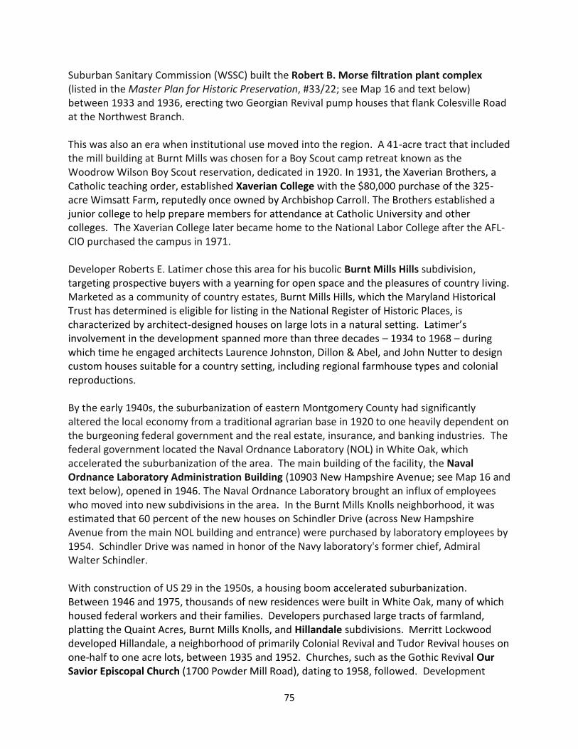
75
Suburban Sanitary Commission (WSSC) built the Robert B. Morse filtration plant complex (listed in the Master Plan for Historic Preservation, #33/22; see Map 16 and text below) between 1933 and 1936, erecting two Georgian Revival pump houses that flank Colesville Road at the Northwest Branch. This was also an era when institutional use moved into the region. A 41-acre tract that included the mill building at Burnt Mills was chosen for a Boy Scout camp retreat known as the Woodrow Wilson Boy Scout reservation, dedicated in 1920. In 1931, the Xaverian Brothers, a Catholic teaching order, established Xaverian College with the $80,000 purchase of the 325-acre Wimsatt Farm, reputedly once owned by Archbishop Carroll. The Brothers established a junior college to help prepare members for attendance at Catholic University and other colleges. The Xaverian College later became home to the National Labor College after the AFL-CIO purchased the campus in 1971. Developer Roberts E. Latimer chose this area for his bucolic Burnt Mills Hills subdivision, targeting prospective buyers with a yearning for open space and the pleasures of country living. Marketed as a community of country estates, Burnt Mills Hills, which the Maryland Historical Trust has determined is eligible for listing in the National Register of Historic Places, is characterized by architect-designed houses on large lots in a natural setting. Latimer’s involvement in the development spanned more than three decades – 1934 to 1968 – during which time he engaged architects Laurence Johnston, Dillon & Abel, and John Nutter to design custom houses suitable for a country setting, including regional farmhouse types and colonial reproductions. By the early 1940s, the suburbanization of eastern Montgomery County had significantly altered the local economy from a traditional agrarian base in 1920 to one heavily dependent on the burgeoning federal government and the real estate, insurance, and banking industries. The federal government located the Naval Ordnance Laboratory (NOL) in White Oak, which accelerated the suburbanization of the area. The main building of the facility, the Naval Ordnance Laboratory Administration Building (10903 New Hampshire Avenue; see Map 16 and text below), opened in 1946. The Naval Ordnance Laboratory brought an influx of employees who moved into new subdivisions in the area. In the Burnt Mills Knolls neighborhood, it was estimated that 60 percent of the new houses on Schindler Drive (across New Hampshire Avenue from the main NOL building and entrance) were purchased by laboratory employees by 1954. Schindler Drive was named in honor of the Navy laboratory's former chief, Admiral Walter Schindler. With construction of US 29 in the 1950s, a housing boom accelerated suburbanization. Between 1946 and 1975, thousands of new residences were built in White Oak, many of which housed federal workers and their families. Developers purchased large tracts of farmland, platting the Quaint Acres, Burnt Mills Knolls, and Hillandale subdivisions. Merritt Lockwood developed Hillandale, a neighborhood of primarily Colonial Revival and Tudor Revival houses on one-half to one acre lots, between 1935 and 1952. Churches, such as the Gothic Revival Our Savior Episcopal Church (1700 Powder Mill Road), dating to 1958, followed. Development
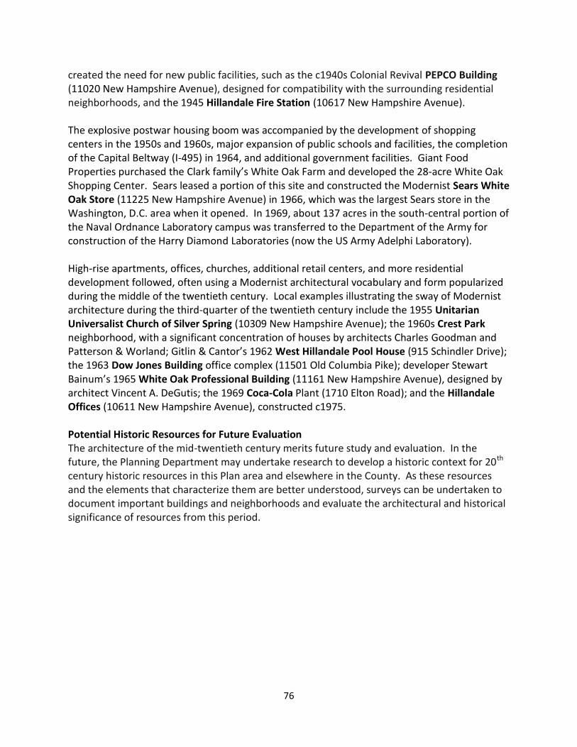
76
created the need for new public facilities, such as the c1940s Colonial Revival PEPCO Building (11020 New Hampshire Avenue), designed for compatibility with the surrounding residential neighborhoods, and the 1945 Hillandale Fire Station (10617 New Hampshire Avenue). The explosive postwar housing boom was accompanied by the development of shopping centers in the 1950s and 1960s, major expansion of public schools and facilities, the completion of the Capital Beltway (I-495) in 1964, and additional government facilities. Giant Food Properties purchased the Clark family’s White Oak Farm and developed the 28-acre White Oak Shopping Center. Sears leased a portion of this site and constructed the Modernist Sears White Oak Store (11225 New Hampshire Avenue) in 1966, which was the largest Sears store in the Washington, D.C. area when it opened. In 1969, about 137 acres in the south-central portion of the Naval Ordnance Laboratory campus was transferred to the Department of the Army for construction of the Harry Diamond Laboratories (now the US Army Adelphi Laboratory). High-rise apartments, offices, churches, additional retail centers, and more residential development followed, often using a Modernist architectural vocabulary and form popularized during the middle of the twentieth century. Local examples illustrating the sway of Modernist architecture during the third-quarter of the twentieth century include the 1955 Unitarian Universalist Church of Silver Spring (10309 New Hampshire Avenue); the 1960s Crest Park neighborhood, with a significant concentration of houses by architects Charles Goodman and Patterson & Worland; Gitlin & Cantor’s 1962 West Hillandale Pool House (915 Schindler Drive); the 1963 Dow Jones Building office complex (11501 Old Columbia Pike); developer Stewart Bainum’s 1965 White Oak Professional Building (11161 New Hampshire Avenue), designed by architect Vincent A. DeGutis; the 1969 Coca-Cola Plant (1710 Elton Road); and the Hillandale Offices (10611 New Hampshire Avenue), constructed c1975. Potential Historic Resources for Future Evaluation The architecture of the mid-twentieth century merits future study and evaluation. In the future, the Planning Department may undertake research to develop a historic context for 20th century historic resources in this Plan area and elsewhere in the County. As these resources and the elements that characterize them are better understood, surveys can be undertaken to document important buildings and neighborhoods and evaluate the architectural and historical significance of resources from this period.
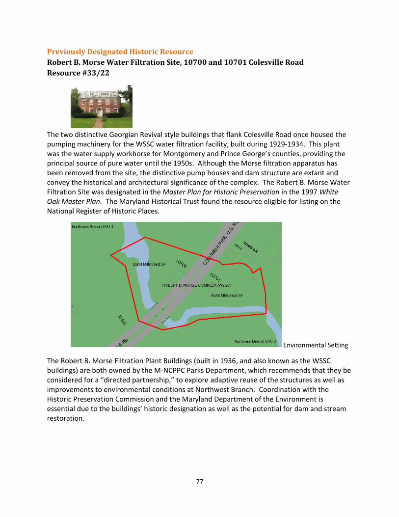
77
Previously Designated Historic Resource
Robert B. Morse Water Filtration Site, 10700 and 10701 Colesville Road
Resource #33/22
The two distinctive Georgian Revival style buildings that flank Colesville Road once housed the pumping machinery for the WSSC water filtration facility, built during 1929-1934. This plant was the water supply workhorse for Montgomery and Prince George’s counties, providing the principal source of pure water until the 1950s. Although the Morse filtration apparatus has been removed from the site, the distinctive pump houses and dam structure are extant and convey the historical and architectural significance of the complex. The Robert B. Morse Water Filtration Site was designated in the Master Plan for Historic Preservation in the 1997 White Oak Master Plan. The Maryland Historical Trust found the resource eligible for listing on the National Register of Historic Places.
Environmental Setting
The Robert B. Morse Filtration Plant Buildings (built in 1936, and also known as the WSSC buildings) are both owned by the M-NCPPC Parks Department, which recommends that they be considered for a “directed partnership,” to explore adaptive reuse of the structures as well as improvements to environmental conditions at Northwest Branch. Coordination with the Historic Preservation Commission and the Maryland Department of the Environment is essential due to the buildings’ historic designation as well as the potential for dam and stream restoration.
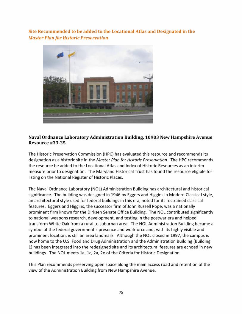
78
Site Recommended to be added to the Locational Atlas and Designated in the
Master Plan for Historic Preservation
Naval Ordnance Laboratory Administration Building, 10903 New Hampshire Avenue Resource #33-25 The Historic Preservation Commission (HPC) has evaluated this resource and recommends its designation as a historic site in the Master Plan for Historic Preservation. The HPC recommends the resource be added to the Locational Atlas and Index of Historic Resources as an interim measure prior to designation. The Maryland Historical Trust has found the resource eligible for listing on the National Register of Historic Places.
The Naval Ordnance Laboratory (NOL) Administration Building has architectural and historical significance. The building was designed in 1946 by Eggers and Higgins in Modern Classical style, an architectural style used for federal buildings in this era, noted for its restrained classical features. Eggers and Higgins, the successor firm of John Russell Pope, was a nationally prominent firm known for the Dirksen Senate Office Building. The NOL contributed significantly to national weapons research, development, and testing in the postwar era and helped transform White Oak from a rural to suburban area. The NOL Administration Building became a symbol of the federal government’s presence and workforce and, with its highly visible and prominent location, is still an area landmark. Although the NOL closed in 1997, the campus is now home to the U.S. Food and Drug Administration and the Administration Building (Building 1) has been integrated into the redesigned site and its architectural features are echoed in new buildings. The NOL meets 1a, 1c, 2a, 2e of the Criteria for Historic Designation. This Plan recommends preserving open space along the main access road and retention of the view of the Administration Building from New Hampshire Avenue.
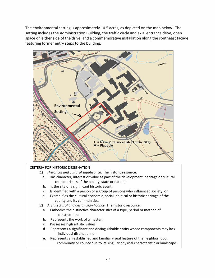
79
The environmental setting is approximately 10.5 acres, as depicted on the map below. The setting includes the Administration Building, the traffic circle and axial entrance drive, open space on either side of the drive, and a commemorative installation along the southeast façade featuring former entry steps to the building.
Environmental
Setting
Boundary
CRITERIA FOR HISTORIC DESIGNATION (1) Historical and cultural significance. The historic resource:
a. Has character, interest or value as part of the development, heritage or cultural characteristics of the county, state or nation;
b. Is the site of a significant historic event; c. Is identified with a person or a group of persons who influenced society; or
d. Exemplifies the cultural economic, social, political or historic heritage of the county and its communities.
(2) Architectural and design significance. The historic resource: a. Embodies the distinctive characteristics of a type, period or method of construction;
b. Represents the work of a master; c. Possesses high artistic values; d. Represents a significant and distinguishable entity whose components may lack individual distinction; or e. Represents an established and familiar visual feature of the neighborhood, community or county due to its singular physical characteristic or landscape.

80
81
COMMUNITY FACILITIES The White Oak area has a mix of land uses, including shopping centers, business parks, and institutional uses, as well as single-family and multi-family communities. The Plan area contains two public schools, a fire station, two local parks, and the new White Oak Community Recreation Center. In the center of the Plan area is the Federal Research Center (FRC) at White Oak, home to the Food and Drug Administration (FDA), which has extensive recreation facilities for its employees, including a fitness center, soccer and softball fields, walking paths, athletic clubs, and a bicycle commuter group. The Paint Branch Stream Valley Park traverses the Plan area and the Northwest Branch Stream Valley Park forms the boundary between the White Oak and Four Corners communities. Community facilities that are outside, but adjacent to, the Plan area include the White Oak Library, Martin Luther King, Jr. Recreational Park, several local parks, and public schools. The Third District Police Station is under construction in the northeast quadrant of New Hampshire Avenue and US 29 (see Map 16). Parks, Open Spaces, and Recreation Existing Parks There are two local parks within the Plan area boundary. The 22.5-acre Hillandale Local Park at 10615 New Hampshire Avenue is adjacent to the FRC, the Hillandale Fire Station, and the CHI Center (formerly known as the Centers for the Handicapped). Land for this park was acquired by the M-NCPPC in 1943 and it currently includes two tennis courts, two basketball courts, a playground, two diamond fields with a rectangular field overlay, as well as the Hillandale Park Office Building. The Planning Board approved demolition of the Hillandale Park Activity Building and the former Adult Education Building due to their poor condition and numerous operational issues (including problems with the septic system). The park is scheduled to undergo Facility Planning by the Department of Parks and removal of these structures will facilitate the best possible redesign of the park to better meet the needs of the community. Stonehedge Local Park is located at 12121 Old Columbia Pike. The 1997 Fairland Master Plan recommended that land be acquired to create this 4.4-acre park, which includes a half sized basketball court, two playgrounds, a volleyball court, and a rectangular youth field. The Northwest Branch Stream Valley Park is part of the Northwest Branch watershed which, with an area of 33,920 acres, is the largest watershed of the Anacostia River tributaries. The headwaters of the Northwest Branch start in Olney and Sandy Spring and the stream flows through White Oak and into Prince George’s County where it joins with the Northeast Branch to form the Anacostia River. The unpaved trails in the stream valley park have been designated the Rachel Carson Greenway Trail since they are near the White Oak/Quaint Acres residence of Ms. Carson, author of Silent Spring. The park also includes two landmark, historic buildings at the Northwest Branch crossing of US 29, which are owned by M-NCPPC. The architecture and
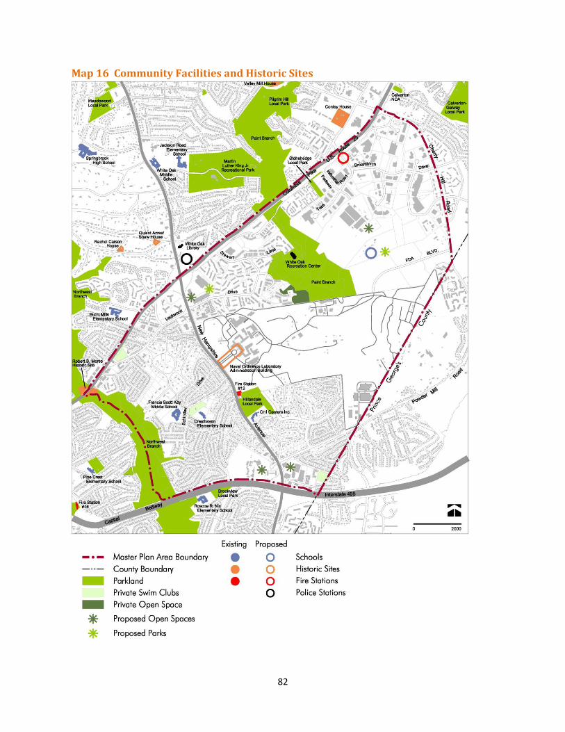
82
Map 16 Community Facilities and Historic Sites
83
setting of these buildings, which are former WSSC water filtration pump stations, help define the entrance to the White Oak area. The site includes parking and access to the trailhead locations on both sides of US 29. The Paint Branch Stream Valley Park is part of the 20,160-acre Paint Branch watershed, which extends from Spencerville Road through White Oak, the FRC, and into Prince George’s County where it meets the Northeast Branch of the Anacostia River. The park includes an existing paved trail between Jackson Road and Fairland Road and a paved trail is proposed between Fairland Road and the ICC right-of-way (see Map 14). Martin Luther King Jr. Recreational Park is the largest park with active recreation facilities near the White Oak area. The 95-acre park is located on Jackson Road, off New Hampshire Avenue, adjacent to White Oak Middle School, Jackson Road Elementary School, and the Paint Branch Stream Valley Park to the east. It contains an indoor aquatic center and exercise room, outdoor pools; playgrounds; tennis, volleyball, and basketball courts; ball fields; picnic shelters, and hiker-biker trails, including connections to Paint Branch Stream Valley Park trails. This Plan explored the possibility of providing White Oak residents south of US 29 with better access to the Recreational Park by extending the paved trail in the Paint Branch Stream Valley Park south of Jackson Road and under US 29 and Old Columbia Pike. Unfortunately, a paved trail to the south is not possible due to steep slopes, access requirements for the disabled, and potential environmental impacts; however, a natural surface trail may be possible and is included in this Plan’s recommendations. Park, Recreation, and Open Space Needs For the eastern County, which includes this Plan area, the 2005 Land Preservation, Parks, and Recreation Plan/Park, Recreation and Open Space Plan (LPPRP/PROS) estimated an unmet need for five adult rectangular fields and one youth rectangular field. Since 2005, two adult fields have been constructed, one at Cross Creek Local Park and one at the White Oak Community Recreation Center, as well as one youth field at Stonehedge Local Park, leaving an estimated unmet need of three adult sized rectangular fields for the entire eastern County. One or two fields may be possible at the newly acquired Athey property in Burtonsville. The Vision 2030 Strategic Plan, approved by the Planning Board in 2011, indicated that the most important facilities to improve and expand are recreation centers, aquatic facilities, health and fitness facilities, trails, natural areas, playgrounds, athletic fields, dog parks, and community gardens. Vision 2030 also recommends the strategic location of skate parks and volleyball courts. Some of the park and recreation needs of the Plan area have already been met by existing indoor recreation, health and fitness facilities, community meeting rooms, and a skate park at the White Oak Community Recreation Center. According to current park planning policies contained in the 2012 PROS Plan, approved by the Planning Board in July 2012, the following facilities will be needed for the future development of the Plan area, some of which should be located within public parks and some of which may be within public use space on private property:
a civic green in the area of highest density

84
an interconnected system of sidewalks and trails
community open spaces in areas planned for increased residential densities
dog park(s)
community garden(s)
playgrounds in every node
one to two adult sized rectangular fields
a plaza at each transit stop or mixed use center
useable outdoor “pocket” or neighborhood green space at each block
private outdoor space where possible for residential units (balconies) Park, Recreation, and Open Space (PROS) Plan The 2012 PROS Plan established new guidelines for urban parks. Recognizing that the pattern of open space systems in areas of increasing density should support vibrant mixed-use centers, PROS recommends open spaces that will be comfortable, attractive, easily accessible, and provide a range of experiences, including festival and outdoor event spaces. The system of parks and open spaces for each master plan or sector plan area should be provided through a combination of public and private efforts. Those open spaces that rise to the level of serving as a focal point of community life for the Plan area are typically recommended to be publicly owned and operated parks, while those open spaces serving districts, nodes, or neighborhoods are often recommended as public use spaces to be provided by the private sector. Attributes of the County’s parks and open space system include active recreation, social interaction, access to green space, relaxation and stress relief, public accessibility, educational value, walkability, connectivity, flexibility, and activating uses. PROS established six new categories of urban parks in a revised Park Classification System, including: Civic Green Urban Park, Countywide Urban Recreational Park, Urban Greenway, Neighborhood Green Urban Park, Urban Buffer Park, and Community Use Recreational Park (see Appendix E). Several of these park types are recommended for the centers in this Plan. Parks Recommendations The recommendations for parks, open spaces, and trails aim to provide space for unmet needs following the guidance from PROS and Vision 2030 while organizing spaces into an interconnected system of parks and open spaces within and between each of the Plan’s potential redevelopment areas. Future opportunities to co-locate and provide inter-generational services should be explored as new developments proceed. Area-wide recommendations are discussed below, followed by recommendations for each center. Expansion of Park Maintenance Facilities When redevelopment and new development occurs, several new parks and facilities may be built that will require a higher level of maintenance and policing than a typical local park. To accommodate the planned growth of parks, this Plan recommends expanded maintenance facilities within or near the Plan area, co-located with other publicly owned parcels if possible.
85
Dog Parks Off-leash dog parks will likely be in demand in the Plan area since it includes many multi-family residences with no open space for dogs to run freely. Dog parks require a higher level of management than many other park facilities. If they become overcrowded, conflicts may require attention from Park Police. If they are small, the surfacing must be regularly replaced. The Plan encourages incorporating privately owned and operated dog “spots” in public use areas or within the private outdoor space of high density residential buildings. Dog spots are the smallest of the three types of dog parks identified in the 2012 PROS Plan. Parkland Acquisition Opportunities This Plan recommends that opportunities for acquisition of additional parkland to meet identified goals (such as stewardship, trail connectivity, or recreational needs) should be pursued by the Department of Parks. Specific opportunities and recommendations for new parkland are discussed below for each center. In addition, private swim club properties or other larger assemblages of properties that become available should be considered for public acquisition.
Parks Recommendations for Centers White Oak/FDA Center As discussed in this Plan, there is potential for mixed-use redevelopment of the White Oak Shopping Center (at the southeast quadrant of New Hampshire Avenue and Colesville Road) and possibly the commercial uses along the south side of Lockwood Drive. Redevelopment would provide an opportunity for more parkland and open spaces in this high density area, particularly an open lawn for a variety of activities, trees for shade and a sense of contact with nature, and areas for community gatherings. Connectivity for walkers and bicyclists should also be improved, including a possible pedestrian connection between this center and the adjacent FRC property.
Recommendations
Provide an urban plaza, approximately three quarters of an acre, privately owned and managed, in the core of a redeveloped White Oak Shopping Center to serve as a public gathering place near a transit stop and as a focus of commercial activity.
Provide a Neighborhood Green Urban Park, approximately two acres, to serve as a green community open space for a variety of activities including picnicking, pick-up sports, and relaxing on the lawn. The park could include other local amenities such as community gardens and a dog park. It would be owned and managed by the Department of Parks, and should be located at the Center’s eastern edge nearest the existing multi-family residences.
Improve connectivity for walking and cycling to the nearby White Oak Community Recreation Center to the east via bike paths, and to the Martin Luther King Recreational Park to the north and Hillandale Local Park to the south via a shared use bike path on New Hampshire Avenue.
86
Create a new pedestrian path between the FDA campus and the retail center to encourage walking and provide better access for employees.
Connect the commercial center to the existing residential neighborhood to the east by providing a recreation loop/shared use path, consisting of sidewalks and bikeways that provides better access between the residential and commercial areas.
Provide pedestrian and bicyclist connections to local destinations such as the White Oak Community Recreation Center, the North White Oak/Cherry Hill area via Old Columbia Pike bridge, the bikeway on New Hampshire Avenue, and to regional trails and bikeways.
Designate approximately 130 acres of forest along the main stem of the Paint Branch through the Federal Research Center (FRC) as a Legacy Open Space (LOS) Natural Resource site if a surplus of land occurs in the future. If these high quality, sensitive environmental resource areas on the FRC site should become available through a surplus process, the LOS designation would allow their acquisition as parkland and provide stewardship for parkland and trail links in the Plan area. The core area of the FRC forest, which includes mature century-old (or older) forest supporting forest interior dwelling species, is a high quality natural resource that could fill a key gap in public access to the Paint Branch Stream Valley Park. The recommended LOS Natural Resource area excludes known structures and improvements.
Hillandale Community The Hillandale Shopping Center and Hillandale Local Park are on the east side of New Hampshire Avenue, and the National Labor College is on the west side of New Hampshire Avenue. If the shopping center redevelops, an urban plaza for gathering in the retail area will be needed. The existing Hillandale Local Park needs renovation and reconfiguration. The play area is hidden from view, parking and vehicular circulation are disjointed, and the Park Activity Building is underused. While removal of the Park Activity Building provides opportunities to redesign the park, the site has little or no room for new fields. This Plan recommends exploring opportunities with the FRC for possible expansion of Hillandale Local Park’s land area to allow for additional facilities to meet community needs. Recommendations
Provide an urban plaza, approximately half an acre in size, owned and managed by the private sector, to create an attractive and relaxing environment for people who live, work, and visit the redeveloped center.
Remove the Park Activity Building and repurpose parkland with facilities that are in demand, such as community open space and reconfigured play areas. The final program and park design will be determined through the currently funded Facility Plan.
Consider acquiring land from the FRC property adjacent to Hillandale Local Park to allow for needed facilities such as an adult rectangular field.
North White Oak/Cherry Hill Road Center This Center, bounded by Colesville Road, Cherry Hill Road, and the Paint Branch Stream Valley Park, includes the 185-acre Percontee parcel and the 115-acre Site 2 parcel that are planned for
87
new mixed-use development, including retail, residential, and offices. The area also includes the 49-acre Adventist Healthcare property that has development approval for a new Washington Adventist Hospital.
New development on the 300-acre Percontee/Site 2 properties should be sensitive to the adjacent Paint Branch Stream Valley Park and should provide extensive open space opportunities. Parks, trails, and recreational opportunities are needed for the future population of residents, workers, and visitors, including places for formal and informal gatherings, active recreation, spontaneous play, contact with nature, as well as connections within this center and beyond to other destinations. The existing 4.4-acre Stonehedge Local Park, which contains two playgrounds, a basketball court, and a small multi-use field, is inadequate to meet the needs of a new high-density, mixed-use center.
Recommendations
Provide a Civic Green Urban Park, approximately one acre, to serve as a gathering space and focal point in the highest density cluster of retail and residential uses that may function as a “town center.” The Civic Green should be a formally planned, flexible, programmable open space, with a central lawn area.
Provide a Local Park with a large adult-sized rectangular athletic field and other amenities such as a community garden, dog park, basketball courts, community open space, urban wooded areas, and play areas. Provide on-street parking to the extent possible and assume a reduction from the typical parking standards applied by the Department of Parks, since many park users could walk or take transit. For the athletic fields, consider synthetic turf and lighting to provide longer hours of use and higher overall capacity. To maximize efficiencies of parking and community use, co-locate with a proposed elementary school, which will be needed if potential residential densities are achieved. If other potential public amenities, such as a community meeting space or a library are proposed, also consider co-location with the park.
Incorporate privately owned and managed public use spaces similar to Neighborhood Green Urban Parks for each district in the 300-acre development with open lawn areas, shaded seating, play structures, community gardens, and dog spots, or similar neighborhood recreation facilities.
Incorporate a trailhead on parkland with interpretive signage, and a natural surface trail to the stream along the old roadbed, at the eastern edge of the Paint Branch Stream Valley Park. Dedication of additional land may be needed to accomplish this.
Create an integrated trail and bikeway system that connects perimeter trails to destinations throughout the development. All trails and park facilities, except for a carefully sited natural surface trail to the river along the old roadbed, should remain outside of sensitive areas. Accordingly, a perimeter trail, whether a bikeway along a road right-of-way, or a hard surface trail on expanded parkland, should be located adjacent to the top of the stream valley, thereby offering visual access into the stream valley park throughout its length, and physical access only by the natural surface trail. Any hard surface trails should be outside the environmental buffers, except where needed as a crossing, in accordance with the practice of first avoiding, then minimizing,
88
and then mitigating impacts. To reinforce public access to the edge of the stream valley, there should be no private lots backing up to the stream valley park.
Explore provision of a trail connecting to the potential walking path around the regional storm water pond on the proposed Washington Adventist Hospital site.
Designate approximately 20 acres of steeply sloped, mature forest at the edge of development along the Paint Branch Stream Valley Park as a Legacy Open Space Natural Resource site. At time of regulatory review, determine whether this forest resource should be preserved through easement and/or dedication to Parks.
Locate trails or bikeways along the edge of the regulatory stream buffers by providing additional parkland (approximately 50-100 feet wide) to keep the trails out of the buffers.
Include a sustainably designed multi-use natural surface trail connecting the Plan area to Martin Luther King Recreational Park. A hard surface trail is not recommended because it adversely impacts sensitive resources, entails significant topographic challenges (connecting to Old Columbia Pike), and requires long stretches of boardwalk, which is expensive to install and maintain in a floodplain.
Burnt Mills
Activate the Robert B. Morse Filtration Plant Buildings (built in 1936 and also known as the WSSC buildings) through a “directed partnership,” coordinated with the Department of Parks’ Public Affairs and Community Partnerships Division, investing in the adaptive reuse of the structures and in improvements to environmental conditions at Northwest Branch. Coordinate with the Historic Preservation Commission since the buildings are designated on the Master Plan for Historic Preservation and with the Maryland Department of the Environment due to the dam and potential stream restoration.
Public Schools The Master Plan area is part of Montgomery County Public School’s Northeast Consortium high school cluster, an innovative program that allows students to choose from three high schools in the area - James Hubert Blake, Paint Branch, and Springbrook. In addition to the three high schools, the cluster includes five middle schools and seventeen elementary schools. Cresthaven Elementary School and Francis Scott Key Middle School, both recently modernized, are located within the Plan area’s boundaries in the west Hillandale neighborhood. Elementary school students in the area attend Roscoe Nix Elementary School for grades K-2 and Cresthaven Elementary School for grades three to five. Many of the elementary schools serving the Plan area are at or over capacity, while others are under capacity and are projected to remain so. The schools where enrollment exceeds capacity use re-locatable classrooms to handle the extra students until additions are built. The three elementary schools that serve the majority of the plan area, Galway, Cresthaven, and Roscoe Nix, are all projected to be slightly over capacity in the future, but not by enough to warrant additions. If the residential development projected in this Plan comes to fruition, a new elementary school site will be needed.
89
Five middle schools serve the Northeast Consortium and all are currently within capacity. Three of the five middle schools – Banneker, Francis Scott Key, and White Oak – are projected to be slightly over capacity in the future, but not by enough to warrant additions. At the high school level, students in the Plan area may choose between the three Northeast Consortium high schools depending on their academic interests. Paint Branch and Springbrook high schools are projected to be within their capacities. Blake High School is projected to slightly exceed its capacity by 2017, but not by enough to warrant an addition. Recommendation This Plan recommends that an adequate site for a future public elementary school be dedicated on the Percontee property, should the enrollment projections prepared by Montgomery County Public Schools determine that a new school is necessary.
Libraries
The nearest library serving the Plan area is the White Oak Library, at 11701 New Hampshire Avenue, less than one mile northwest of US 29. The 16,205-square foot library was built in 1967 and renovated in 1989. The library has two meeting rooms that can be reserved by community groups. There are currently no plans for expansion or renovation of the White Oak Library. The Marilyn J. Praisner, Wheaton, Silver Spring, and Long Branch libraries also serve east County residents. The Marilyn J. Praisner Library (formerly named the Fairland Library) opened in 1995 and is located at 14910 Old Columbia Pike in Burtonsville. The 17,454-square foot library is co-located with the 25-acre Columbia Local Park and the Marilyn J. Praisner Community Recreation Center. The library includes two meeting rooms that can be reserved by community groups and a Discovery Room for early childhood learning that can be reserved by parents or caregivers with small children. The Wheaton Library is located at 11701 Georgia Avenue (at Arcola Avenue) adjacent to the Wheaton Neighborhood Recreation Center. It is one of the County’s busiest branches with over 600,000 items circulated each year and more than 425,000 annual visits. Plans to replace the library and the adjacent community center in a joint library/community center facility are currently underway. The library and recreation center will be comparable to other facilities of similar service needs, and will have shared use of some space including lobbies, meeting rooms, restrooms, and parking. Since 1957, the 13,600-square foot Silver Spring Library has been located on Colesville Road, three miles south of White Oak. A new 65,000-square foot library is under construction at Wayne Avenue and Fenton Street in downtown Silver Spring. The new library is scheduled to open in fall 2014 and will include a computer lab, group study and tutor rooms, a partitioned meeting room and a quiet study room, early literacy elements for use by parents and young children in the children’s room, an area for teens, and expanded book collections for all age groups on three separate floors of the multi-story building.
90
The Long Branch Library is located at 8800 Garland Avenue. The 21,034-square foot library opened in 1960 and was renovated in 1990. Recreation Centers The 1997 Fairland Master Plan noted that there were no recreation centers in Fairland but, since that time, two centers have been completed - the East County Community Recreation Center and the Marilyn J. Praisner Community Recreation Center, which opened in 2002. The 1997 White Oak Master Plan also recommended that a new community recreation center be provided, in the vicinity of the high density housing on Stewart and April Lanes in White Oak. The White Oak Community Recreation Center opened in June 2012 at 1700 April Lane, in the heart of the high density, multi-family neighborhood, providing new recreation options within walking distance of many area residents. The 33,000-square foot facility includes a gymnasium with indoor basketball courts, exercise room, game room, multi-use athletic court, kitchen, community meeting rooms, conference rooms and other amenities. Outdoor recreation includes a skate area with ramps, a basketball court, two playgrounds, and a small multi-purpose athletic field. Police The Plan area is served by the Third District Police Station, with a service area that covers most of the eastern part of the County. The Third District Station has been located on Sligo Avenue in Silver Spring for nearly 50 years. In 2013, a new Police Station for the Third District will open on Milestone Drive in the northeast quadrant of the New Hampshire Avenue/US 29 interchange, replacing the downtown station. There is currently a police sub-station at the East County Regional Services Center, located near the intersection of US 29 and Briggs Chaney Road.
Fire, Rescue, and Emergency Medical Services
The Master Plan area is served primarily by Hillandale Fire Station 12, located at 10617 New Hampshire Avenue adjacent to Hillandale Local Park. Surrounding fire stations that also serve the area, as needed, include Burtonsville Station 15 (13900 Old Columbia Pike), Hillandale Station 24 (13216 New Hampshire Avenue), and Beltsville Station 41 (Prince Georges County) located on Powder Mill Road at I-95. In addition, resources from more distant fire stations respond into the area when needed. To adequately meet the fire, rescue, and emergency medical services (EMS) needs of the area over the next 20 years, existing stations and resources must continue operating and additional resources will be required. A study of the East County conducted by the Montgomery County Fire and Rescue Service indicates that existing fire suppression and EMS resources serving the area will not meet the projected incident volume or the County-adopted response time goals. To address these needs, a fire station with a paramedic-engine and medic unit has been recommended for the east County in the vicinity of US 29 and Tech Road, within the North White Oak/Cherry Hill Road Center.
91
Recommendation The fire station should be located within approximately one-half mile of the US 29/Tech Road intersection on a site that meets suitability criteria established by Montgomery County Fire and Rescue Service in the Fire, Rescue, EMS, and Community Risk Reduction Master Plan. The entrance to Site 2 along Industrial Parkway is a potential site for the fire station as are several privately owned properties in the vicinity. Regional Services Center The Eastern Montgomery Regional Services Center is located at 3300 Briggs Chaney Road, about two miles northeast of White Oak. It is one of five Countywide Regional Services Centers whose purpose is to be a conduit between County government and County residents. The East County Center accommodates the East County Citizens’ Advisory Board, houses a County police sub-station, and is adjacent to a County Health and Human Services facility and the East County Community Recreation Center. CHI Centers CHI Centers (formerly known as Centers for the Handicapped) is located in the former Hillandale Elementary School building at 10501 New Hampshire Avenue, adjacent to Hillandale Local Park. For over 60 years, CHI Centers, a private non-profit organization, has provided support services to adults with developmental disabilities in Montgomery, Prince George’s, and Howard counties. CHI Centers helps to create the conditions that allow persons with disabilities to have opportunities to participate in community life and be afforded respect and dignity. For many years, CHI has provided meeting rooms for the community, in particular, the Hillandale Citizens Association. The 61,793-square foot building was constructed in 1952 and is on a 6.8-acre site that it is owned by Montgomery County. It is expected that CHI Centers will continue to provide their invaluable services to the community at this location. Recommendation Efforts to improve access between CHI Centers and Hillandale Local Park should be explored through the facility planning process to redesign and renovate the park.

92
93
IMPLEMENTATION AND STAGING Staging Overview Growth and change must be managed and timed with the delivery of the infrastructure necessary to support it. Transforming the White Oak area requires a transit and road network that will support increased densities and changes to the built environment and mix of uses over a long period of time. This Plan seeks to guide future public and private investment and development in a manner that meets the area’s needs while collectively benefitting and enhancing the communities of White Oak. This Plan’s staging recommendations address the timing of development in relation to the infrastructure needed to support it. The Subdivision Staging Policy (SSP) is used to establish the policies and procedures for administration of the Adequate Public Facilities Ordinance (APFO), which, as of the time of this Plan, involves three tests for adequacy: Transportation Policy Area Review (TPAR), Local Area Transportation Review (LATR), and the Public Schools Facilities Test. The goal of the APFO is to ensure that transportation and school facilities have sufficient capacity for the Planning Board to approve specific projects during the regulatory approval process. The 2012-2016 SSP concluded that the Fairland/White Oak Policy Area (which covers this Plan area and most of the eastern County) has inadequate roadway transportation capacity conditions. Any new development in this area will need to fully mitigate the incremental traffic impact by adding capacity, implementing a trip reduction program, or making a transportation mitigation payment that would contribute toward an eventual improvement addressing the particular inadequacy. In addition to the APFO requirements in the SSP, this Plan recommends staging to ensure that infrastructure, particularly BRT, is in place before significant amounts of development are allowed to proceed in the three major activity centers where the bulk of development is anticipated. Outside of the three centers, only the APFO requirements in the SSP apply. Staging helps achieve the desired level of growth and ensures that the transportation network is sufficient to accommodate the next phases of growth. This Plan provides stages and amounts of development that are tied to infrastructure and transportation management goals (see Table 6). Experience shows that the full density allowed by zoning is rarely built and certainly not all at once. Market demand and absorption rates are two of the limiting factors. Therefore, the maximum potential development of the zoning proposed in this Plan is almost certain to be more density than will be used over the life of the Plan. Keeping track of the actual development that occurs will be particularly important to assess how the area is developing, the need for and programming of infrastructure, and whether the vision is being achieved. The mechanism for tracking these issues will be a biennial monitoring program, as discussed below. This Plan may need to be amended if transit and road infrastructure are not being programmed and constructed.
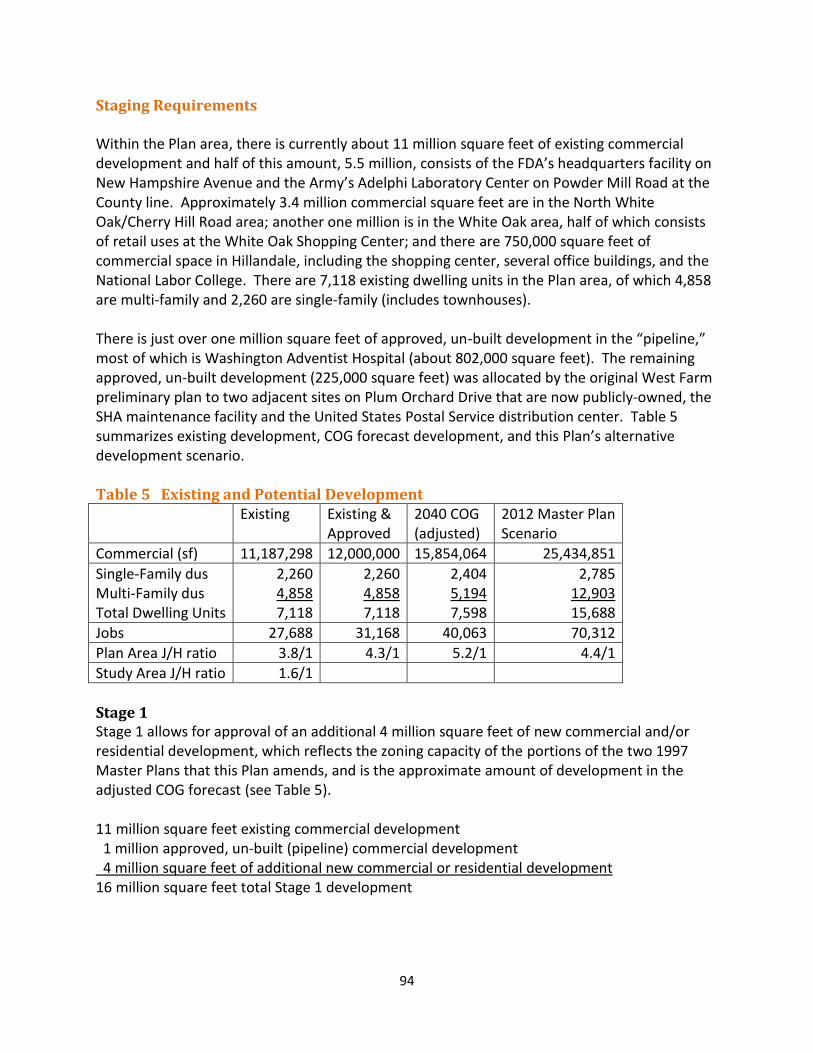
94
Staging Requirements Within the Plan area, there is currently about 11 million square feet of existing commercial development and half of this amount, 5.5 million, consists of the FDA’s headquarters facility on New Hampshire Avenue and the Army’s Adelphi Laboratory Center on Powder Mill Road at the County line. Approximately 3.4 million commercial square feet are in the North White Oak/Cherry Hill Road area; another one million is in the White Oak area, half of which consists of retail uses at the White Oak Shopping Center; and there are 750,000 square feet of commercial space in Hillandale, including the shopping center, several office buildings, and the National Labor College. There are 7,118 existing dwelling units in the Plan area, of which 4,858 are multi-family and 2,260 are single-family (includes townhouses). There is just over one million square feet of approved, un-built development in the “pipeline,” most of which is Washington Adventist Hospital (about 802,000 square feet). The remaining approved, un-built development (225,000 square feet) was allocated by the original West Farm preliminary plan to two adjacent sites on Plum Orchard Drive that are now publicly-owned, the SHA maintenance facility and the United States Postal Service distribution center. Table 5 summarizes existing development, COG forecast development, and this Plan’s alternative development scenario. Table 5 Existing and Potential Development
Existing Existing & Approved
2040 COG (adjusted)
2012 Master Plan Scenario
Commercial (sf) 11,187,298 12,000,000 15,854,064 25,434,851
Single-Family dus Multi-Family dus Total Dwelling Units
2,260 4,858 7,118
2,260 4,858 7,118
2,404 5,194 7,598
2,785 12,903 15,688
Jobs 27,688 31,168 40,063 70,312
Plan Area J/H ratio 3.8/1 4.3/1 5.2/1 4.4/1
Study Area J/H ratio 1.6/1
Stage 1 Stage 1 allows for approval of an additional 4 million square feet of new commercial and/or residential development, which reflects the zoning capacity of the portions of the two 1997 Master Plans that this Plan amends, and is the approximate amount of development in the adjusted COG forecast (see Table 5). 11 million square feet existing commercial development 1 million approved, un-built (pipeline) commercial development 4 million square feet of additional new commercial or residential development 16 million square feet total Stage 1 development
95
In Stage 1, the Plan recommends allocating development to each of the three major nodes in recognition of the importance of the individual centers of White Oak, Hillandale, and North White Oak/Cherry Hill Road in successfully achieving this Plan’s vision. In Hillandale and White Oak, the ability to add housing in places now exclusively devoted to commercial activity offers a potentially significant redevelopment incentive. In North White Oak/Cherry Hill, where redevelopment has already been established as an important County public policy, emphasizing non-residential development in the initial stages appropriately supports that policy. Development projects will be required to demonstrate how they are addressing the Plan vision and how the Plan’s urban design guidelines (regarding areas such as building relationships, compatibility, and public spaces) for the particular center are being achieved. While the three centers are allocated a total of 6 million square feet, no more than 4 million square feet may be developed in the Plan area in Stage 1. For example, if the White Oak and Hillandale centers receive building permits with 500,000 square feet of new development in each area, there would be 3 million square feet available in the North White Oak/Cherry Hill Road Center during Stage 1. Or, if the White Oak and Hillandale centers receive building permits totaling 750,000 square feet in each center, there would be 2.5 million square feet available in the North White Oak/Cherry Hill Road Center during Stage 1. The 4 million square feet of additional new development available in Stage 1 will be geographically allocated to each of three areas (with new development density allocated at the time a building permit is issued) as follows:
White Oak Center will have up to 1.5 million square feet for either commercial or residential development or a mix of commercial and residential uses per the recommended zoning.
Hillandale Center will have up to 1.5 million square feet for either commercial or residential development or a mix of commercial and residential uses per the recommended CR zones.
North White Oak/Cherry Hill Road Center will have up to 3 million square feet of commercial or a combination of commercial and residential development, with residential development limited to a maximum of 1 million square feet.
The Planning Board will have the discretion to review and revise the Stage 1 Plan allocations attributed to each Center, if needed, based on how development activity proceeds as applications are submitted to the Planning Department for regulatory approval and based on the subsequent issuance of building permits. If, for example, there are development projects in the North White Oak/Cherry Hill Road Center that exceed the 3 million allocated to that area in Stage 1 and, at the same time, there is no proposed development in the other centers, the Planning Board could decide to allow more than 3 million, but no more than the total of 4 million in Stage 1.
96
In addition, if a Preliminary Plan in one of the major activity centers - that is existing and valid when the Plan is approved - expires during the course of Stage 1, the development capacity associated with it becomes available to the major activity center it is in. All of the pipeline development in the Plan area is in the North White Oak/Cherry Hill Road Center and consists primarily of the approval for Washington Adventist Hospital. Currently, this approved, un-built project is part of the 12 million square feet of existing and approved development in Stage 1. If the hospital’s Preliminary Plan expires, this amount of development would shift from the category of existing and approved development to the category of additional new development in the North White Oak/Cherry Hill Road Center, while the total in Stage 1 would remain the same. Development capacity in each stage will be allocated at building permit (rather than at Preliminary Plan) through a Staging Allocation Request (SAR). For a single building, an applicant must receive core and shell building permit approval from the Department of Permitting Services (DPS) within 90 days after Planning Board SAR approval. A staging allocation approval is valid for two years from the date of the Planning Board’s Resolution granting the staging allocation. Any applicant whose building permits are not issued within the two-year validity period loses any allocated but unused capacity. For multiple buildings, an applicant must receive core and shell building permit approval from DPS within 180 days after the Planning Board SAR approval. The validity period is three years. A biennial monitoring report, which is a prerequisite of Stage 1, will be produced during the spring of odd-numbered years. It will include a section describing any recommended amendments to existing Project Description Forms (PDF) in the CIP or new PDFs to be added to the subsequent biennial CIP (developed for public hearing in the spring of even-numbered years). This monitoring report could also address whether any changes to the Subdivision Staging Policy (SSP) are needed, a particularly important element considering that the SSP and this Master Plan cannot anticipate the full range of circumstances that will arise in the future. The Planning Board and County Council may consider changes to the SSP at any time (i.e., they need not wait for a biennial review), but they must consider the performance of the SSP at the time of the biennial review. Before Stage 1 begins, all of the following must occur:
Approve and adopt the Sectional Map Amendment (SMA).
Create a new Policy Area (a subset of the Fairland/White Oak Policy Area) using the boundaries of the Plan area, but retain the CLV congestion standard for the new Policy Area at 1475.
Develop a transportation approval mechanism and monitoring program within 12 months of adopting the Sectional Map Amendment. The Planning Board must develop a biennial monitoring program that includes
periodic assessment of development approvals, public facilities and amenities, the status of new facilities, and the CIP and SSP as they relate to the White Oak area. The program must include a Local Area Transportation Review (or comparable analysis) that will identify and recommend for Council approval and action specific
97
projects and services necessary to promote adequate transportation service. The program should include a regular assessment of the staging plan and determine if any modifications are necessary. The biennial monitoring report must be submitted to the Council and Executive prior to the development of the biennial CIP.
The Planning Board must establish an advisory committee of property owners, residents and interested groups that are stakeholders in the redevelopment of the Plan area, as well as representatives from the Executive Branch, to evaluate the assumptions made regarding congestion levels and transit use. The committee’s responsibilities should include monitoring the Plan recommendations, identifying new projects for the Amenity Fund, monitoring the CIP and SSP, and recommending action by the Planning Board and County Council to address issues that may arise.
Document the baseline non-auto driver mode share (NADMS) for the new policy area through monitoring and traffic counts.
Remove the Trip Reduction restrictions that were placed on certain properties in the North White Oak area through the 1990 Trip Reduction Amendment to the 1981 Eastern Montgomery County Master Plan. Property owners who executed voluntary trip reduction agreements with the Planning Board may take action to have these restrictions removed from the land records.
Stage 2 16 million square feet of Stage 1 development +5 million square feet of Stage 2 additional new commercial development +2000 - Total Stage 2 additional residential dwelling units Before Stage 2 begins, mobility enhancements must be achieved and must include programming of one of the following infrastructure improvements that provides the greatest transportation capacity increase:
BRT on US 29 from the Silver Spring Transit Center to the Burtonsville Park and Ride Lot must be fully funded for implementation and construction within the first six years of the County’s CIP or the State’s Consolidated Transportation Program (CTP). OR
BRT on New Hampshire Avenue from US 29 to the Takoma/Langley Purple Line Transit Center must be fully funded for implementation and construction within the first six years of the County’s CIP or the State’s Consolidated Transportation Program (CTP). OR
Any master-planned transportation improvements identified as needed by the most recent biennial monitoring review must be programmed for completion within six years.
In addition, before Stage 2 begins, the following must occur:
Increase the CLV congestion standard for the new Policy Area (that was created in Stage 1) to 1600 (which is the current standard in Bethesda/Chevy Chase, Kensington/Wheaton, Silver Spring/Takoma Park and the Germantown Town Center).
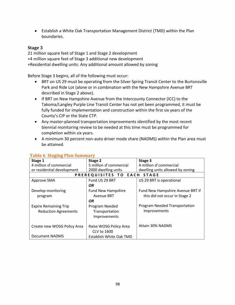
98
Establish a White Oak Transportation Management District (TMD) within the Plan boundaries.
Stage 3 21 million square feet of Stage 1 and Stage 2 development +4 million square feet of Stage 3 additional new development +Residential dwelling units: Any additional amount allowed by zoning Before Stage 3 begins, all of the following must occur:
BRT on US 29 must be operating from the Silver Spring Transit Center to the Burtonsville Park and Ride Lot (alone or in combination with the New Hampshire Avenue BRT described in Stage 2 above).
If BRT on New Hampshire Avenue from the Intercounty Connector (ICC) to the Takoma/Langley Purple Line Transit Center has not yet been programmed, it must be fully funded for implementation and construction within the first six years of the County’s CIP or the State CTP.
Any master-planned transportation improvements identified by the most recent biennial monitoring review to be needed at this time must be programmed for completion within six years.
A minimum 30 percent non-auto driver mode share (NADMS) within the Plan area must be attained.
Table 6 Staging Plan Summary
Stage 1 4 million sf commercial or residential development
Stage 2 5 million sf commercial 2000 dwelling units
Stage 3 4 million sf commercial dwelling units allowed by zoning
P R E R E Q U I S I T E S T O E A C H S T A G E
Approve SMA Develop monitoring program Expire Remaining Trip Reduction Agreements Create new WOSG Policy Area Document NADMS
Fund US 29 BRT OR Fund New Hampshire Avenue BRT OR Program Needed Transportation Improvements Raise WOSG Policy Area CLV to 1600 Establish White Oak TMD
US 29 BRT is operational Fund New Hampshire Avenue BRT if this did not occur in Stage 2 Program Needed Transportation Improvements
Attain 30% NADMS
99
Sectional Map Amendment Following the Plan’s approval by the County Council and adoption by The Maryland-National Capital Park and Planning Commission, a Sectional Map Amendment (SMA) will apply the Plan’s recommended zoning to the official zoning map of the County. Design Guidelines The Planning Board will review and approve design guidelines that will help guide developers, the community, and staff in implementing the Plan. Public Benefits in the CR Zone
The CR Zone has two development methods: standard and optional. The standard method allows up to 0.5 FAR in the CR Zone and up to 1.0 FAR in the CRT Zone and requires compliance with a specific set of development standards. The optional method allows for greater density and height but requires projects to provide public benefits to achieve the incentive density above the standard method density. The additional optional method density may be achieved through a series of incentive increases that can be combined to achieve the maximum allowable density. Public benefits provided under the optional method are drawn from among seven categories outlined in the Zoning Ordinance.
The following list of public benefits should be considered priorities during project development and review of optional method projects in the CR Zone within the boundaries of this Plan. This list is not mandatory nor does it preclude consideration of other benefits listed in the CR Zone to achieve the maximum permitted FAR. The requested benefits should be analyzed to make sure they are the most suitable for a particular location and consistent with the Plan’s vision, and that they satisfy the changing needs of the area over time. When selecting these benefits, the Planning Board should consider community needs as a determining factor.
Major public facilities o Bus Rapid Transit o Bus circulator to connect centers to BRT stations o Elementary school o Parks
Transit proximity
Connectivity between uses, activities, and mobility options o Trip mitigation o Neighborhood Services o Streetscape o Way-finding
Diversity of uses and activities o Affordable Housing o Dwelling Unit Mix o Care Centers
Quality building and site design o Structured Parking

100
o Public Open Space
Protection and Enhancement of the Natural Environment o Energy Conservation and Generation o Tree Canopy
Financing Mechanisms This Plan will be implemented over a long period of time, on a property-by-property basis, through a combination of public and private initiatives such as redevelopment and upgrading of private properties, public projects funded through Federal, State, and County Capital Improvement Programs, and public/private partnership projects. In addition to these implementation methods, other mechanisms may need to be pursued subsequent to the approval of this Plan to explore possible funding sources for infrastructure improvements. This Plan recommends that County and State agencies explore the full range of tools that might be available to implement this Plan. Possible tools include a special taxing district, which is the public financing mechanism being used to implement the White Flint Sector Plan. To provide greater assurance of achieving the Sector Plan’s goals for White Flint, the County Council enacted the White Flint Special Tax District to create a funding source for transportation infrastructure improvements in the Plan area. Commercial property owners within the special tax district make payments that fund specific road improvements in the District and the County can authorize bonds to finance these improvements. The tax will finance transportation improvements which, elsewhere in the County, are financed or provided through impact tax revenues or credits or by the private sector as required under the applicable LATR and TPAR requirements. The transportation issues and problems in White Oak are significantly different from White Flint, which is a compact area with a Metro Station within its boundaries. White Oak is a much larger area (3,000 acres), with significant regional traffic traversing the area and with transit that is currently limited to conventional buses. There is no easy solution to the long standing traffic problems. The recommended infrastructure improvements include grade-separated interchanges on US 29 and a bus rapid transit system. Some of these improvements are within the Plan boundaries but most are aimed at creating a regional road and transit network that would benefit many constituencies, not just the few property owners that may redevelop in the Plan area. It is challenging to devise a financing mechanism for infrastructure improvements that benefit a region by using techniques that apportion the cost of those facilities to a specific set of localized property owners. Other possible funding mechanisms include a development district, a transportation impact tax, a special benefit assessment, or tax increment financing. Development districts are a tool through which new development can generate revenue to pay for infrastructure. Development districts are flexible as to the method of raising revenue (fee, charge, tax) and can be set up so that only new development pays for the tax and unimproved land pays a charge. Transportation impact taxes collect money from new development (that are putting demands on the
101
transportation system) in order to pay for capacity-adding projects within a designated district. Impact tax rates and payment schedules or structures can differ from district to district. County Capital Improvements Program The Capital Improvements Program (CIP), which is funded by the County Council and implemented by County agencies, establishes how and when construction projects are completed. The CIP cycle starts every two years when regional advisory committees and the M-NCPPC hold forums to discuss proposed items for the six-year CIP. This Plan’s land use and staging recommendations will require the inclusion of the following projects as elements of the CIP. Some projects may include private sector participation.
In the Plan area, priority should be given to the following CIP projects:
bus rapid transit (as described in this Plan’s staging element)
reconstructing the Old Columbia Pike bridge over the Paint Branch
a new elementary school, if needed
routes and facilities in the proposed bike and trail network, particularly the shared use loops in the North White Oak/Cherry Hill Road Center and in the White Oak/FDA Center, including the proposed connection to FDA.
102
ACKNOWLEDGMENTS
Rose Krasnow, Interim Director Project Team Area 2 Division
Glenn Kreger, Chief Khalid Afzal Nancy Sturgeon (lead planner) Luis Estrada Cepero Amy Lindsey Marc Lewis-DeGrace
Area 3 Division Fred Boyd Functional Planning and Policy Division Mary Dolan, Chief Tom Autrey David Anspacher Eric Graye Clare Lise Kelly Scott Whipple Sandra Youla Research and Technology Division Richard DeBose, Chief Lisa Tate Kimberly Colopinto Park Planning, Department of Parks Brooke Farquhar Charles Kines Brenda Sandberg Dom Quattrocchi Joey Lampl Management Services Valerie Berton Sam Dixon Claudia Kousoulas Kevin Leonard Brian Kent James Sumler
103
The Plan Process A plan provides comprehensive recommendations for the use of publicly and privately owned land. Each plan reflects a vision of the future that responds to the unique character of the local community within the context of a countywide perspective. Together with relevant policies, plans should be referred to by public officials and private individuals when making land use decisions. The STAFF DRAFT PLAN is prepared by the Montgomery County Planning Department for presentation to the Montgomery County Planning Board. The Planning Board reviews the Staff Draft Plan, makes preliminary changes as appropriate, and approves the Plan for public hearing. After the Planning Board’s changes are made, the document becomes the Public Hearing Draft Plan. The PUBLIC HEARING DRAFT PLAN is the formal proposal to amend an adopted master plan or sector plan. Its recommendations are not necessarily those of the Planning Board; it is prepared for the purpose of receiving public testimony. The Planning Board holds a public hearing and receives testimony, after which it holds public worksessions to review the testimony and revise the Public Hearing Draft Plan as appropriate. When the Planning Board’s changes are made, the document becomes the Planning Board Draft Plan. The PLANNING BOARD DRAFT PLAN is the Planning Board’s recommended Plan and reflects their revisions to the Public Hearing Draft Plan. The Regional District Act requires the Planning Board to transmit a master plan or sector plan to the County Council with copies to the County Executive who must, within sixty days, prepare and transmit a fiscal impact analysis of the Planning Board Draft Plan to the County Council. The County Executive may also forward to the County Council other comments and recommendations. After receiving the Executive’s fiscal impact analysis and comments, the County Council holds a public hearing to receive public testimony. After the hearing record is closed, the relevant Council committee holds public worksessions to review the testimony and makes recommendations to the County Council. The Council holds worksessions, then adopts a resolution approving the Planning Board Draft, as revised. After Council approval, the plan is forwarded to The Maryland-National Capital Park and Planning Commission for adoption. Once adopted by the Commission, the plan officially amends the master plans, functional plans, and sector plans cited in the Commission’s adoption resolution.
104
Elected and Appointed Officials County Council
Nancy Navarro, President Craig Rice, Vice President Phil Andrews Roger Berliner Marc Elrich Valerie Ervin Nancy Floreen George Leventhal Hans Riemer
County Executive
Isiah Leggett The Maryland-National Capital Park and Planning Commission Elizabeth M. Hewett, Chair Françoise Carrier, Vice Chair
Commissioners
Montgomery County Planning Board Françoise M. Carrier, Chair Marye Wells-Harley, Vice Chair Casey Anderson Norman Dreyfuss Amy Presley
Prince George's County Planning Board Elizabeth M. Hewett, Chair Dorothy F. Bailey, Vice Chair Manuel R. Geraldo John P. Shoaff A. Shuanise Washington